England Coast Path Stretch: Mablethorpe to Easington Nature Conservation Assessment
←
→
Page content transcription
If your browser does not render page correctly, please read the page content below
www.gov.uk/englandcoastpath

England Coast Path Stretch:
Mablethorpe to Easington
Nature Conservation Assessment

1   England Coast Path | Humber Bridge to Easington | Overview
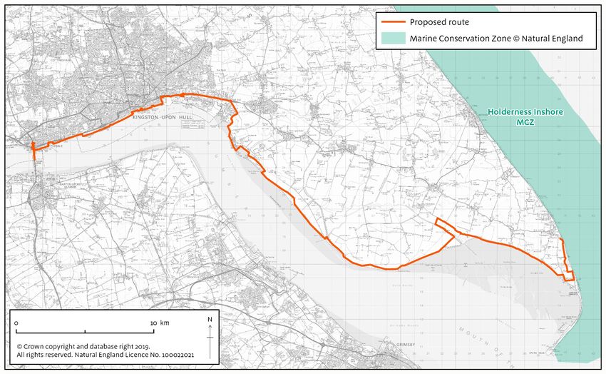
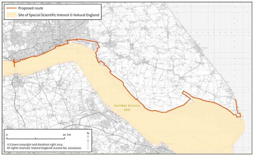
About this document
This document should be read in conjunction with the published Reports for the Mablethorpe to
Humber Bridge stretch and the Humber Bridge to Easington stretch and the Habitats Regulations
Assessment (HRA).

The Coastal Access Reports contain a full description of the access proposals, including any
additional mitigation measures that have been included.

A HRA is required for European sites (SPA, SAC and Ramsar sites). The HRA is published
alongside the Coastal Access Reports.

This document, the Nature Conservation Assessment (NCA), covers all other aspects (including
SSSIs, MCZs and undesignated but locally important sites and features) in so far as any HRA
does not already address the issue for the sites and feature(s) in question.

The NCA is arranged site by site. Maps A-F shows designated sites along this stretch of coast.

See Annex 1 for an index to designated sites and features for this stretch of coast, including
features that have been considered within the HRA.

2   England Coast Path | Mablethorpe to Easington | Nature Conservation Assessment
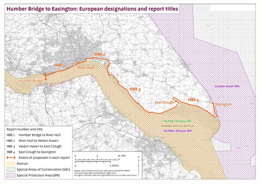
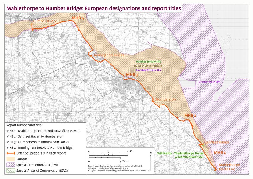
Contents

About this document ............................................................................................................... 2

Contents .................................................................................................................................... 3

Introduction............................................................................................................................... 4

Humber Estuary SSSI .............................................................................................................. 5

Saltfleetby-Theddlethorpe Dunes SSSI .............................................................................. 16

North Killingholme Haven Pitts SSSI .................................................................................. 21

The Lagoons SSSI ................................................................................................................. 23

Holderness Inshore MCZ ...................................................................................................... 25

Roesel’s bush-cricket............................................................................................................ 26

Protected Species .................................................................................................................. 27

Conclusion .............................................................................................................................. 28

Map A. Designated Sites: Humber Estuary SSSI (south bank) ...................................... 30

Map B. Designated sites: North Killingholme Haven Pitts SSSI .................................... 31

Map C. Designated sites: Saltfleetby and Theddlethorpe Dunes SSSI......................... 32

Map D. Designated site: Humber Estuary SSSI (north bank) ......................................... 33

Map E. Designated sites: The Lagoons SSSI .................................................................... 34

Map F. Other designations ................................................................................................... 35

Map G.Mablethorpe to Humber Bridge:European designations and report titles ...... 36

Map H. Humber Bridge to Easington: European designations and report titles ........ 37

Annex 1. Index to designated sites and features ............................................................ 38

3    England Coast Path | Mablethorpe to Easington | Nature Conservation Assessment
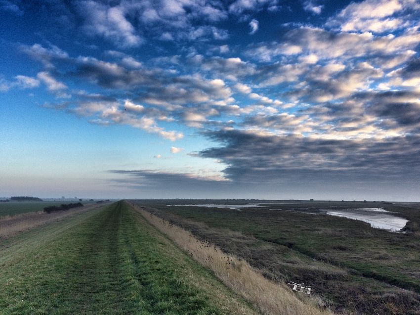
Introduction
This is a surprisingly varied section of coastline, with a number of interesting and diverse features.
The habitats range from saltmarsh, coastal lagoons and standing water to sand dunes, intertidal
mud, sand and subtidal sediments, sand banks and coastal cliffs and foreshore. It is a constantly
changing landscape due to the tidal movements and weather conditions.

The coast and coastal fringe is of national and international importance for nature conservation and
some habitats support internationally significant populations of birds, grey seals, vascular plants
and invertebrates.

The area is covered by a number of designations including SSSIs, MCZ, SAC, SPA, NNR and
Ramsar site.

A number of coastal towns and settlements act as access points for tourists, day visitors and
recreational users. The central point of these two stretches is marked by the Humber Bridge, a
large suspension bridge spanning the Humber. The towns of Hull, Grimsby and Immingham have
significant industrial heritage and important docks, and Cleethorpes is a popular destination in the
tourism sector. The area is also renowned for its bird watching and wildlife photography
opportunities throughout the north and south bank.

The England Coast Path (ECP) proposals follow public rights of way and existing walked routes
along some sections of the trail. It also secures an associated coastal margin for the public to
enjoy. Where sensitive nature locations exist the proposals have considered limiting access at
certain times and locations. The proposals have been developed in conjunction with Natural
England’s area teams, National Nature Reserve staff, local partners, and partnership groups
including the Humber Nature Partnership, Yorkshire Wildlife Trust, Lincolnshire Wildlife Trust,
Royal Society for the Protection of Birds, Ministry of Defence, British Trust for Ornithology, Spurn
Bird Observatory, county and district councils and local access and recreational groups.

4   England Coast Path | Mablethorpe to Easington | Nature Conservation Assessment
Assessment of coastal access proposals on:

Humber Estuary SSSI
Is this site also part of a European site? Yes

This SSSI overlaps with the European sites of:-
      •   Humber Estuary SAC
      •   Humber Estuary SPA
      •   Humber Estuary Ramsar site
      •   Greater Wash SPA

Notified features of the SSSI that are also qualifying features of the European designated site are
omitted from this assessment, as they are considered as part of the HRA (Habitat Regulations
Assessment). For a detailed list of overlapping features and designated sites please see Annex 1.
These features are:-

    SSSI Notified Feature           Site Designation                  Overlapping European
                                                                      Designated Site

    Estuaries                       SSSI/Ramsar site/SAC              Humber Estuary Ramsar site
                                                                      and Humber Estuary SAC

    Aggregations of non-breeding    SSSI/Ramsar site/SPA              Humber Estuary Ramsar site
    birds – bar-tailed godwit                                         and Humber Estuary SPA

    Aggregations of non-breeding    SSSI/Ramsar site/SPA              Humber Estuary Ramsar site
    birds – dunlin                                                    and Humber Estuary SPA

    Aggregations of non-breeding    SSSI/Ramsar site/SPA              Humber Estuary Ramsar site
    birds – redshank                                                  and Humber Estuary SPA

    Aggregations of non-breeding    SSSI/Ramsar site/SPA              Humber Estuary Ramsar site
    birds – shelduck                                                  and Humber Estuary SPA

    Sea lamprey                     SSSI/Ramsar site/SAC              Humber Estuary Ramsar site
                                                                      and Humber Estuary SAC

    River lamprey                   SSSI/Ramsar site/SAC              Humber Estuary Ramsar site
                                                                      and Humber Estuary SAC

    Aggregations of non-breeding    SSSI/Ramsar site/SPA              Humber Estuary Ramsar site
    birds – ruff                                                      and Humber Estuary SPA

    Aggregations of non-breeding    SSSI/Ramsar site/SPA              Humber Estuary Ramsar site
    birds – golden plover                                             and Humber Estuary SPA

5     England Coast Path | Mablethorpe to Easington | Nature Conservation Assessment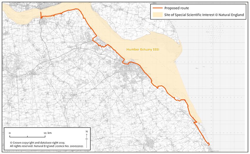
SSSI Notified Feature           Site Designation                  Overlapping European
                                                                      Designated Site

    Aggregations of non-breeding    SSSI/Ramsar site/SPA              Humber Estuary Ramsar site
    birds – bittern                                                   and Humber Estuary SPA

    Aggregations of non-breeding    SSSI/Ramsar site/SPA              Humber Estuary Ramsar site
    birds – knot                                                      and Humber Estuary SPA

    Aggregations of non-breeding    SSSI/Ramsar site/SPA              Humber Estuary Ramsar site
    birds – black-tailed godwit                                       and Humber Estuary SPA

    Aggregations of non-breeding    SSSI/Ramsar site/SPA              Humber Estuary Ramsar site
    birds – avocet                                                    and Humber Estuary SPA

    Grey seal                       SSSI/Ramsar site/SAC              Humber Estuary Ramsar site
                                                                      and Humber Estuary SAC

    Moderately exposed sandy        SSSI/Ramsar site                  Humber Estuary Ramsar site
    shores (with polychaetes and
    bivalves)

    Saline coastal lagoons          SSSI/Ramsar site/SAC              Humber Estuary Ramsar site
                                                                      and Humber Estuary SAC

    Fixed dune grassland            SSSI/Ramsar site/SAC              Humber Estuary Ramsar site
                                                                      and Humber Estuary SAC

    SD1-6 Sand dune; strandline,    SSSI/Ramsar site/SAC              Humber Estuary Ramsar site
    embryo and mobile dunes                                           and Humber Estuary SAC

    SM4-28 Saltmarsh                SSSI/Ramsar site/SAC              Humber Estuary Ramsar site
                                                                      and Humber Estuary SAC

    MG11 Festuca rubra –            SSSI/Ramsar site                  Humber Estuary Ramsar site
    Agrostis stolonifera –
    Potentilla anserina grassland

Subtidal features and standing waters are not covered by this assessment, as the coastal access
proposals are not within scope of these features.

This assessment covers the following features:
      •   Vascular plant assemblage
      •   Invertebrate assemblage
      •   Geology: EC – Quaternary of East England and IA – Coastal geomorphology
      •   Assemblages of breeding birds – Lowland open waters and their margins
      •   Aggregations of non breeding birds – curlew
6     England Coast Path | Mablethorpe to Easington | Nature Conservation Assessment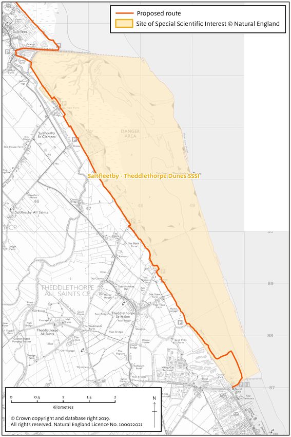
•   Aggregations of non breeding birds – dark-bellied brent goose
    •   Aggregations of non breeding birds – goldeneye
    •   Aggregations of non breeding birds – greenshank
    •   Aggregations of non breeding birds – grey plover
    •   Aggregations of non breeding birds – lapwing
    •   Aggregations of non breeding birds – oystercatcher
    •   Aggregations of non breeding birds – pochard
    •   Aggregations of non breeding birds – ringed plover
    •   Aggregations of non breeding birds – sanderling
    •   Aggregations of non breeding birds – scaup
    •   Aggregations of non breeding birds – teal
    •   Aggregations of non breeding birds – turnstone
    •   Aggregations of non breeding birds – whimbrel
    •   Aggregations of non breeding birds - wigeon

Current situation
The Humber Estuary SSSI covers the differing habitats of the estuary (with component habitats of
intertidal mudflats and sandflats and coastal saltmarsh) and the associated saline lagoons, sand
dunes and standing waters. It is split into 187 units and is of national importance for geological
interest and coastal geomorphology of Spurn. The notified features for the SSSI are in a mix of
favourable and unfavourable condition. The whole area has a range of recreational,
business/industrial and pleasure use and this contributes to the impacts on, and therefore varying
SSSI condition status. The significant numbers of recreational users and day visitors for water-
sports, walking, picnicking, dog walkers and other ad hoc recreation may create disturbance for the
internationally and nationally important numbers of non-breeding waterbirds, the nationally
important assemblage of breeding birds, and at Donna Nook the colony of breeding grey seals.

The north shore of the estuary can, for much of its length, be accessed by public rights of way,
often coinciding with the flood defences. In areas where public rights of way do not exist such as
around Sunk Island, between Skeffling and Kilnsea, and from Kilnsea to Easington, informal
access still takes place on the flood banks. The more isolated sections of flood bank are genuinely
remote and are visited much less.

The south shore again, for much of its length, can be accessed by public rights of way. There are
some gaps around Immingham Docks and at Donna Nook Air Weapons Range. In other areas
where public rights of way do not exist such as beyond Horseshoe Point to Tetney Haven, informal
access still takes place on the flood banks.

There are considered to be pinch points at various locations, where visitor impact is higher and
frequency of use is daily and sometimes multiple uses in a day e.g. dog walkers and water sports.
The main pinch points are Cleethorpes to Humberston Fitties, from the leisure centre, and
including Thorpe Park Caravan Park and Tetney Marsh at the Humber Mouth Yacht Club, Donna
Nook for viewing grey seals during the breeding season and Spurn Discovery Centre. These areas
all have existing accessible, well used visitor points.

The coastal path proposals will use existing paths and access routes where possible to try and
ensure access is steered away from sensitive areas. The pressures at Donna Nook for grey seals

7   England Coast Path | Mablethorpe to Easington | Nature Conservation Assessment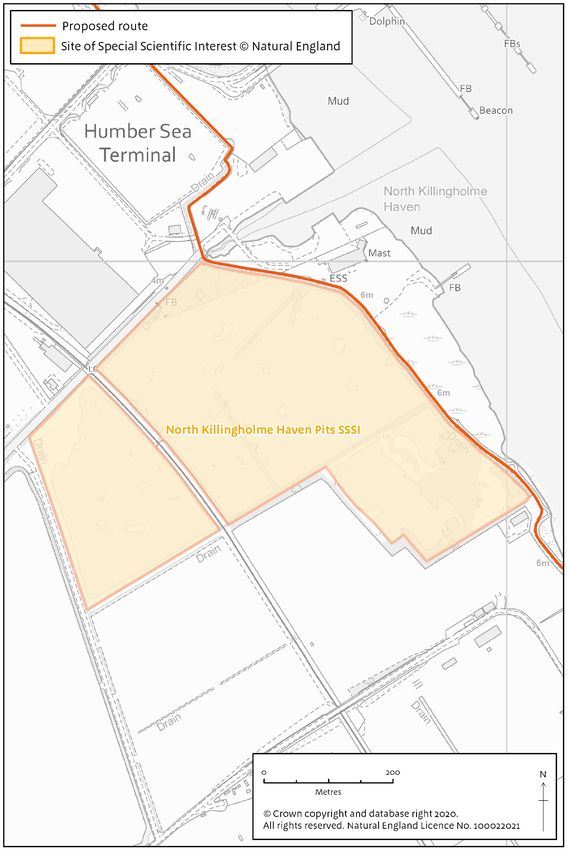
are addressed within the HRA, as are the aggregations of non-breeding waterbirds. River and sea
lamprey are also discussed within the HRA.

The proposals also secure an associated coastal margin of land. The term spreading room to refer
to those parts of the coastal margin, other than the trail itself that will be available to the public for
enjoyment on foot. This does not include areas that that are automatically excepted from coastal
access rights, nor land restricted using the powers under available under Chapter 2 of the
Countryside and Rights of Way Act 2000.

Risk analysis

    Feature (or group of            Location/Consideration              Risk analysis/Conclusion
    features)

    Invertebrate assemblage         Many scarce and threatened          The risks to invertebrates are
                                    species occur within the            considered to be trampling
                                    Humber SSSI, especially             (footfall), compaction and
                                    beetles and moths.                  general disturbance by
                                                                        humans and dogs. Some
                                    Invertebrates associated with       species are sensitive to
                                    estuarine and                       changes in land use, and may
                                    freshwater/terrestrial habitats     look to move if they are
                                    are well represented across         threatened. If a species is
                                    the Humber estuary.                 mobile it could escape, and
                                                                        those able to fly will be less at
                                    The estuary also contains a         risk.
                                    nationally scarce marine
                                    species, the tentacled lagoon       Both the tentacled lagoon
                                    worm Alkmaria romijni, and          worm and the lagoon sand
                                    the lagoon sand shrimp              shrimp are found within water
                                    Gammarus insensibilis. Both         at locations where the
                                    are listed in schedule 5 of the     proposed trail is screened
                                    Wildlife & Countryside Act          from the habitat and where the
                                    1981.                               habitats lie landward of the
                                                                        trail (and therefore not
                                                                        included in spreading room). It
                                                                        is therefore concluded the
                                    The sand dunes at Spurn             species will not affected by the
                                    support the ground beetle           England Coast Path
                                    Amara lucida, the white colon       proposals.
                                    moth Sideridis albicolon and
                                    the shore wainscot moth             Within the assessment the
                                    Mythimna litoralis.                 whole area of the proposals
                                                                        has been considered,
                                                                        including the coastal margin. If
                                                                        people do not keep to the
                                                                        main path, some footfall could
                                                                        impact on areas either side of
                                                                        the path. Some of these areas
                                                                        may contain invertebrates
                                                                        mentioned within the SSSI
                                                                        designation (e.g. ground
                                                                        beetle Amara lucida).
                                                                        However, given there is
8     England Coast Path | Mablethorpe to Easington | Nature Conservation Assessment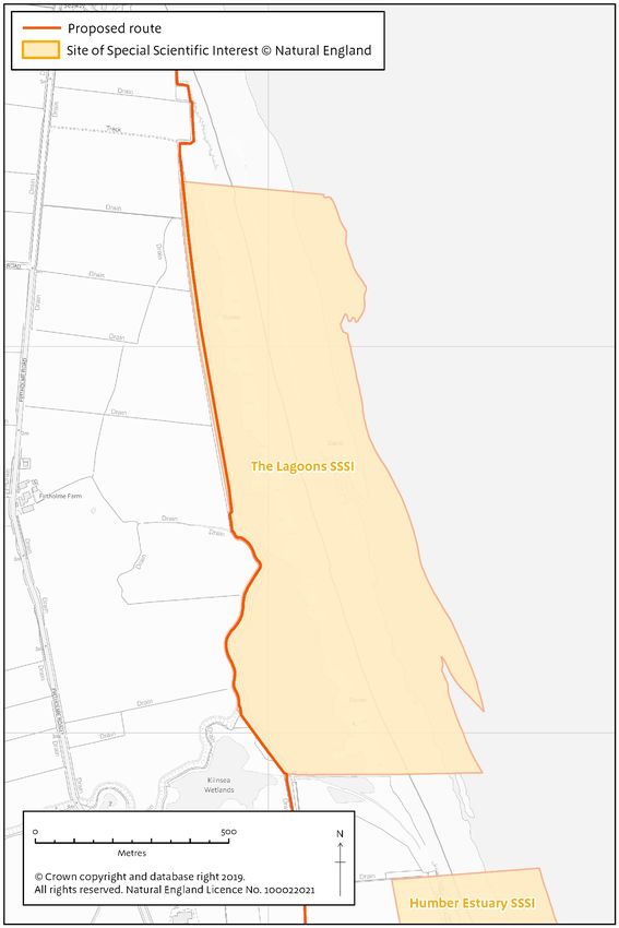
Feature (or group of            Location/Consideration            Risk analysis/Conclusion
    features)
                                                                      already an accepted and
                                                                      managed level of access
                                                                      around Spurn, it is likely the
                                                                      coastal access proposals will
                                                                      not increase this to elevated
                                                                      levels that could present
                                    The saltmarshes (such as          additional risks to
                                    those at Welwick) provide         invertebrates, and therefore it
                                    foraging grounds for the          is concluded no impact on the
                                    solitary bee Colletes             ground beetle or moths.
                                    halophilus. The flowers of sea
                                    aster provide the larval food     At Spurn, the area is
                                    plant for the starwort moth       wardened by the Yorkshire
                                    Cucullia asteris.                 Wildlife Trust. This seeks to
                                                                      control access to the
                                                                      designated paths and prevent
                                                                      desire lines forming. Improved
                                                                      signage will guide people
                                                                      away from sensitive areas and
                                                                      the current provision of visitor
                                                                      facilities and level of
                                                                      wardening suggests the large
                                                                      majority of people will stay on
                                                                      the path. Therefore it is the
                                                                      opinion the proposals will not
                                                                      significantly impact on the
                                                                      bees or moths interest
                                                                      features.

                                                                      The coastal access rights on
                                                                      the saltmarsh and mud flats
                                                                      have either been excluded, as
                                                                      unsuitable for access or for
                                                                      nature conservation reasons,
                                                                      (as part of the HRA), under
                                                                      section 25A or 26(3a) of the
                                                                      CROW Act. These areas are
                                                                      more difficult and dangerous
                                                                      to access with creeks and
                                                                      pans present). The HRA
                                                                      discusses this in more detail.

                                                                      On the basis of the proposed
                                                                      access restrictions, it is
                                                                      unlikely the coastal access
                                                                      proposals will harm to the
                                                                      invertebrate assemblage
                                                                      associated with the saltmarsh
                                                                      habitats. .
                                    Brackish and freshwater reed
                                    beds support the reed beetle      The reed beds are located
                                    Donacia clavipes and the silky    outside the coastal access

9     England Coast Path | Mablethorpe to Easington | Nature Conservation Assessment
Feature (or group of             Location/Consideration             Risk analysis/Conclusion
 features)
                                  wainscot moth Chilodes             provision and will therefore not
                                  maritimus.                         need to be considered in this
                                                                     assessment
                                  Areas of willow scrub within
                                  the reed beds provide the          Scrub areas and the reed
                                  larval food plant for the cream-   beds will not be impacted by
                                  bordered green-pea moth            the proposals, as the route will
                                  Earias clorana.                    not go through these features.
                                                                     In addition, any areas covered
                                                                     by coastal access margin
                                                                     adjacent to the reed beds are
                                                                     also considered low risk for
                                                                     disturbance and human
                                                                     impacts, as these are largely
                                                                     inaccessible on foot.
                                  Fully aquatic species include
                                  the water beetles Agabus           Aquatic species will also not
                                  conspersus and Helophorus          be harmed by the coastal
                                  fulgidicollis.                     access proposals as these
                                                                     habitats are located outside
                                                                     the coast access provision.

 Vascular plant assemblage        The site includes at least ten     The coastal access rights on
                                  nationally scarce species,         the saltmarsh have either
                                  characteristic of coastal and      been excluded, as unsuitable
                                  wetland habitats:                  for access or for nature
                                                                     conservation, (as part of the
                                  Bulbous foxtail, bulbous           HRA), under section 25A or
                                  meadowgrass, divided sedge,        26A of the CROW Act. The
                                  sea buckthorn, slender hare’s-     marshes are reasonably
                                  ear, spiral tasselweed, rush-      difficult and dangerous to
                                  leaved fescue, curved hard-        access with their creeks and
                                  grass, suffocated clover and       pans. This difficulty is
                                  sea clover. Common couch           highlighted in the Access and
                                  sub-species Elytrigia repens       Nature Conservation
                                  ssp. Arenosa is also a notable     Reconciliation supplementary
                                  taxon.                             guidance for England,
                                                                     commissioned by Natural
                                  In addition, to the nationally     England: NPR06/01/003, J
                                  scarce species present, the        Lowen, D Liley, J Underhill-
                                  Humber is interesting              Day, D Whitehouse,
                                  phytogeographically, as it         05/12/2008. This suggests
                                  supports populations of            visitor rates to such areas are
                                  several species that occur at      comparatively low, suggesting
                                  or close to the limits of their    together with the access
                                  geographical range on the          restrictions the vascular plant
                                  east coast of Britain. For         assemblages will not be
                                  example saltmarsh flat-sedge       significantly impacted by the
                                  Blysmus rufus is at its            England Coast path
                                  southern limit, and slender        proposals. Therefore it is
                                  hare’s-ear Bupleurum

10   England Coast Path | Mablethorpe to Easington | Nature Conservation Assessment
Feature (or group of Location/Consideration Risk analysis/Conclusion
features)
tenuissimum is at its northern concluded the features will not
limit. be impacted.
New pathways opening up
could trample features.
Unit 158 Easington Bank has
vascular plant assemblages.
This is located near Kilnsea
Wetlands. It is currently The vascular plant
unfavourable no change assemblage in unit 158 is
condition. The area has been located landward of the
historically horse grazed and England Coast path
the SSSI condition monitoring proposals, with the proposals
records confirm there is no following an existing walked
evidence of sand dune or route on the flood bank. The
marsh communities. The proposal will not impact the
proposals follow the flood- interest features, as the
banks here on an existing coastal access margin only
walked route. extends to the adjacent fence
line.
Unit 85 Pyewipe is listed for
vascular plants. It is the sandy
mudflats area seawards of
unit 86 and is in unfavourable It is concluded the England
recovering condition. Coast Path will have no direct
impacts on unit 85 Pyewipe
Behind the sandflats at vascular plants assemblage,
Cleethorpes on the mature as this area has been
sand dunes, the vegetation excluded from the coastal
supports rare chestnut flat access proposal under section
sedge, bulbous meadowgrass 25 of the CROW Act. The
and dense silky bent. Unit 171 area of saltmarsh beyond the
is listed for vascular plants. At mud flats is also restricted
Spurn Point on the dunes access.
there is Marram grass and sea
buckthorn. Unit 164 Spurn Unit 171 is landward of the
Point has vascular plant proposals and therefore
assemblages. There is outside the scope of the
existing management in place proposals, therefore no impact
across the National Nature on these features.
Reserve to try and protect
sensitive flora and wildlife, and At this location (Spurn, unit
to address the SSSI condition. 164) the trail turns northwards,
away from Spurn Point but the
The colonising saltmarsh at feature is present within
Tetney and along this part of spreading room.
the coast is not typical
Salicornia europaea agg. Unit 164 has active wardening
(Common Glasswort) which is by Yorkshire Wildlife Trust.
found below mean high water This seeks to ensure people
(and is picked as Samphire), keep to the main path. The
trust also have signage to
11 England Coast Path | Mablethorpe to Easington | Nature Conservation AssessmentFeature (or group of Location/Consideration Risk analysis/Conclusion
features)
but rather a mixture of the guide people away from
rarer species such as: sensitive areas and there is
Salicornia dolichostachya existing provision of visitor
(Long-spiked Glasswort), facilities to further inform
Salicornia fragilis (Yellow visitors and proactively
Glasswort), Salicornia manage the site. The trust has
ramosissima (Purple a National Nature Reserve
Glasswort) and Salicornia Management Plan in place
pusilla (One-flowered (July 2019 – June 2024), and
Glasswort) they consider ‘the measures
already in place and those
Likewise, Limonium humile additional likely restrictions
(Lax-flowered Sea-lavender) required as part of the
is known from the same England Coast Path HRA; it is
section of coast. unlikely that this will add
significant additional
pressure’. It is concluded
there will be no impact on the
features of unit 164
It is concluded the England
Coast Path will have no direct
impacts on the Glasswort and
Sea Lavender assemblage at
Tetney, as this area has been
excluded from the coastal
access proposal under section
26a of the CROW Act.
Geology: coastal cliffs and Unit 33, covering 28ha. Late Given the location of this SSSI
foreshore (South Ferriby cliff) Pleistocene sediments. feature and the coast access
quaternary of East England Recorded as favourable proposals there will be no
condition (2010). Relatively interaction with the England
unchanged, but has active Coast Path and therefore no
coastal processes taking impacts on the features.
place. South Ferriby cliff is
located west of the Humber
Bridge and therefore outside
the scope of the proposals.
Geology: Coastal Spurn sits at the mouth of the The geology feature is not
geomorphology (Spurn Head estuary and is a remote, and sensitive to changes in access
SSSI) distinctive peninsula. It is a and is robust to recreational
long sand and shingle spit, pressures. It is concluded
which extends out across the there will be no impact on the
Humber estuary, providing geological feature from the
shelter from the North Sea. It access proposals.
comprises sandy beaches on
the east side, which are
exposed to the action of the
sea, while on the sheltered
12 England Coast Path | Mablethorpe to Easington | Nature Conservation AssessmentFeature (or group of Location/Consideration Risk analysis/Conclusion
features)
west side sediment has been
deposited, and extensive mud
flats and saltmarshes have
developed. Apart from bait
digging, it is considered there It is concluded the coastal
is relatively little disturbance. access proposals will have no
impact on Spurn Bight, as the
Unit 155 Spurn Bight has low CRoW access rights have
shore sandy habitats with been excluded, as unsuitable
polychaetes/amphipods. for access.
There is an extensive network
of creeks and pans with sandy The trail heads northwards
muds. before it reaches this location
(Spurn, unit 164). Spurn Point
Unit 164 Spurn Head contains lies within the coastal access
supra-littoral sediment. The margin, however there are
strandline, mobile and embryo access restrictions in place at
dunes are in favourable this location and it is actively
condition but the unit is failing wardened and managed by
condition on vascular plants, Yorkshire Wildlife Trust to
fixed dune grasslands, ensure access is discrete and
saltmarsh, geomorphology outside sensitive areas.
and assemblage of non- Therefore it is considered no
breeding birds. Positive likely impact from the
management is in place with proposals.
Yorkshire Wildlife Trust
actively managing the site. It is concluded the proposals
There is already parking, will not impact on the geology
toilets and existing footpaths. features. The dune elements
Access is currently restricted are covered within the HRA.
under S25 and S26 to help
managed sensitive flora and
wildlife.
Assemblages of breeding The Humber estuary supports For conclusions on bittern,
birds – Lowland open waters a breeding bird assemblage of redshank, marsh harrier and
and their margins lowland open waters and their avocet please refer to the
margins, including nationally HRA.
important numbers of bittern,
redshank, marsh harrier, The England Coast Path will
avocet and bearded tit (SSSI be supported by
citation). bittern, avocet and improvements to signage, way
marsh harrier are discussed in markers and finger-posts
more detail within the HRA. along this stretch, which will
assist users to follow the trail.
Other birds in the assemblage For further information and
are little grebe, great crested conclusions please refer to the
grebe, mute swan, gadwall, HRA.
shoveler, tufted duck, water
rail, little ringed plover, snipe,
common tern, cuckoo,
kingfisher, yellow wagtail, reed
13 England Coast Path | Mablethorpe to Easington | Nature Conservation AssessmentFeature (or group of Location/Consideration Risk analysis/Conclusion
features)
bunting, and warblers –
grasshopper, sedge and reed.
Most of these birds are
concentrated within the clay
pits, lagoons and reed bed
areas that are located around As the key areas (as identified
Barton (specifically Far Ings, in adjacent column) sit outside
Read’s Island and Blacktoft the scope of the proposals it is
Sands). These areas lie concluded there will be no
outside the scope of the impact from the access
England Coast Path proposals.
proposals, as they are west of
the Humber Bridge.
It is likely some species may
also be found outside these
key areas, as there are other
wetland habitats found locally.
SSSI units 118 – 134 are east Given the current public
of the Humber Bridge and access adjacent to these other
contain wetland areas, which wetland areas, the
are likely to be used by some implementation of the England
of the birds listed within the Coast Path proposals is
SSSI features (e.g. cuckoo, unlikely to have any significant
bearded tit and yellow additional impacts, and it is
wagtail). These units are concluded there will be no
adjacent to the England Coast significant change and no
Path proposals and are mostly impact on these features.
in-land of the route, therefore
outside the scope of the With the proposed access
proposals. Some land is restrictions in place on the
seaward of the route. There mud flats and saltmarsh it is
are already existing walked concluded there will be no
routes along here with a public negative impacts on these
right of way along the length areas from the England Coast
of the flood banks. This runs path proposals, as these are
almost along the full length of aligned with existing linear
this part of the estuary (from walked routes.
the eastern corner at Goxhill
Haven to the Humber Bridge
in the west. There are access
restrictions in place (section
25A) on the mudflats and
marsh, but not the foreshore.
Aggregations of non-breeding These birds are SSSI features Please refer to the HRA for
birds:- only, however they are also discussions and conclusions
part of the non breeding on these features.
• curlew
water-bird assemblage that
• dark-bellied brent forms part of the SPA
goose designation. Wintering
14 England Coast Path | Mablethorpe to Easington | Nature Conservation AssessmentFeature (or group of Location/Consideration Risk analysis/Conclusion
features)
• goldeneye waterfowl and passage
• greenshank waders are widely distributed
• grey plover throughout the estuary, with
• lapwing the distribution of individual
• oystercatcher species reflecting habitat
• pochard distribution and species
• ringed plover ecology.
• Sanderling
Redshank is noted to frequent
• scaup the grazed areas of saltmarsh
• turnstone in several locations on the
• whimbrel estuary including SSSI unit
• wigeon 100 on the south bank and
some areas on the north bank.
The HRA discusses year
round access restrictions to
help protect these features.
The aggregations of non
breeding birds are considered
in further detail as part of the
HRA.
Establishment works
Is SSSI assent needed to implement any specific proposals for establishment works? Yes
New access management infrastructure is required: new surfacing plus some signage and access
ramps. This is discussed further in the HRA.
Where necessary, the land owner(s) will instigate the SSSI assent process by writing to us to
confirm the timing of works and how operations to be undertaken in line with these conditions.
Natural England will provide further advice as necessary
15 England Coast Path | Mablethorpe to Easington | Nature Conservation AssessmentAssessment of coastal access proposals on:
Saltfleetby-Theddlethorpe Dunes SSSI
Is this site also part of a European site? Yes
This SSSI overlaps with the European sites of:-
• Saltfleetby-Theddlethorpe Dunes & Gibraltar Point SAC
• Humber Estuary Ramsar site
• Humber Estuary SPA
• Greater Wash SPA
Notified features of the SSSI that are also qualifying features of the European designated site are
omitted from this assessment, as they are considered as part of the HRA (Habitats Regulations
Assessment).
For a full list of overlapping features and designated sites Annex 1 for further information. These
features are:-
SSSI Notified Feature Site Designation Overlapping European
Designated Site
>20,000 non breeding water birds SSSI/SPA Humber Estuary SPA
Aggregations of breeding birds – SSSI/SPA Humber Estuary
little tern SPA/Greater Wash SPA
Aggregations of non-breeding birds SSSI
– Brent goose
Aggregations of non-breeding birds SSSI/SPA/Ramsar site Humber Estuary
– dunlin SPA/Humber Estuary
Ramsar site
Aggregations of non-breeding birds SSSI/SPA/Ramsar site Humber Estuary
– knot SPA/Humber Estuary
Ramsar site
Aggregations of non-breeding birds SSSI/SPA/Ramsar site Humber Estuary
– redshank SPA/Humber Estuary
Ramsar site
Aggregations of non-breeding birds SSSI
– sanderling
Aggregations of non-breeding birds SSSI
– wigeon
16 England Coast Path | Mablethorpe to Easington | Nature Conservation AssessmentSSSI Notified Feature Site Designation Overlapping European
Designated Site
Moderately exposed sandy shores SSSI/Ramsar site Humber Estuary Ramsar
site
Natterjack toad SSSI/Ramsar site Humber Estuary Ramsar
site
SD2-7 Sand dunes: strandline, SSSI/ SAC/Ramsar site Humber Estuary
embryo and mobile dunes SAC/Saltfleetby-
Theddlethorpe Dunes &
Gibraltar Point
SAC/Humber Estuary
Ramsar site
SD8-9 Sand dunes: dune grassland SSSI/ SAC/Ramsar site Humber Estuary SAC/
Saltfleetby-Theddlethorpe
Dunes & Gibraltar Point
SAC/ Humber Estuary
Ramsar site
SD10 Carex arenaria dune SSSI/SAC/Ramsar site Humber Estuary SAC/
community “fixed” Saltfleetby-Theddlethorpe
Dunes & Gibraltar Point
SAC/ Humber Estuary
Ramsar site
SD17 Potentilla anserin – Carex SSSI/SAC/Ramsar site Humber Estuary SAC/
nigra “humid” dune slack community Saltfleetby-Theddlethorpe
Dunes & Gibraltar Point
SAC/ Humber Estuary
Ramsar site
Sheltered muddy shores (including SSSI/SAC/Ramsar site Humber Estuary
estuarine muds) SAC/Humber Estuary
Ramsar site
SM10 Transitional low marsh SSSI/SAC/Ramsar site Humber Estuary
vegetation with Puccinellia SAC/Humber Estuary
maritima, annual Salicornia species Ramsar site
and Suaeda maritima
This assessment covers the following features:
• Assemblages of breeding birds – scrub
• Invertebrate assemblage
• Vascular plant assemblage
17 England Coast Path | Mablethorpe to Easington | Nature Conservation AssessmentCurrent situation
Saltfleetby-Theddlethorpe Dunes SSSI is split into two units. Unit 1 is littoral sediment and is in
favourable condition (Natural England, 2009). There are no major human influences to disrupt the
interest features and the nature of the habitat (saltmarsh) means this is likely to continue. Unit 2 is
supra-littoral sediment and is in unfavourable-recovering condition. It has a greater human
interference, as it contains dune systems that are accessible to the general public.
This is a nationally important site and the whole area is managed as a National Nature Reserve. It
includes intertidal flats, dunes, freshwater marshes and supports an exceptionally large range of
flora and fauna. Other notable features include Natterjack toads, of which this is the most north
easterly breeding site in Britain. The site also supports extensive feeding and roosting grounds for
wildfowl and waders, and a significant vascular plant assemblage, including a rich orchid flora
found on the interface of freshwater and dune habitats. There is also an invertebrate assemblage
with some notable moths and rare beetles.
The coastal access proposals will run directly adjacent and partly through the dunes of unit 2.
There is already existing access via a public right of way and an existing walked route.
There is a caravan site present at the southern point of the SSSI, which is also the starting point for
this section of the coastal access proposals. The remainder of this length covering the SSSI is
sparsely populated, with Theddlethorpe All Saints and Saltfleetby villages further inland. Current
usage is estimated to be a mix of local residents (dog walkers in the main) plus tourists staying at
the caravan park and other recreational users. Where physically accessible the coastal margin is
already very well used.
Risk analysis
Feature (or group of Location/Consideration Risk analysis/Conclusion
features)
Assemblages of breeding There are breeding birds There are proposals to cut
birds - scrub within the dune scrub with scrub to establish the
some areas containing alternative route for the trail
breeding blackcap, garden during seal breeding season.
warbler, whitethroat and There are no breeding Turtle
nightingale (SSSI citation, 13 Dove known on the section to
October 1988). Turtle Dove be cut.
also breed in the area. The
site is already very well used
(Strava data confirms it is a
regular route and there is Access management
plenty de-facto access infrastructure includes way-
present). markers, advisory signage
and some repairs to the
There is an existing PRoW existing boardwalk near the
along much of this section and sea buckthorn area.
this largely follows the
landward edge of the SSSI. It is considered the proposals
There are also clear desire will cause negligible change in
lines with main access points the current access situation,
and existing walked routes the trail primarily following the
18 England Coast Path | Mablethorpe to Easington | Nature Conservation AssessmentFeature (or group of Location/Consideration Risk analysis/Conclusion
features)
used for people to access the existing public rights of way
beach. and the spreading room
coinciding with previously
designated access land.
Therefore conclude no impact
on these features.
Invertebrates assemblage There is an invertebrate The addition of the England
assemblage present, with Coast Path proposals will
species mostly found within largely follow the existing
the dune scrub. There is PRoW, which is well used. It is
existing public access with considered the proposals will
PRoW along much of the site. not create an increase in
Light trampling or disturbance footfall that would significantly
may be beneficial to increase the risk of damage to
maintaining some areas for invertebrates, as the
invertebrates but an increased invertebrates are mostly found
access could result in within the scrub areas that are
trampling or localised not subject to direct trampling.
damage. It could also
introduce invasive species. It is considered the proposals
will cause negligible change in
the current access situation,
the trail primarily following the
existing public rights of way
and the spreading room
coinciding with previously
designated access land.
Therefore conclude no impact
on these features.
Vascular plant assemblage Unit 2 the dune slacks and There is an existing walked
interface between the route on the dunes, and this is
freshwater and dune systems considered the most resilient
contains rich, abundant flora surface. Some access could
including pyramidal and bee result in trampling, however a
orchids. These are located off low level sward disturbance is
the existing walked routes. considered negligible and light
There are also fen trampling may actually be
communities present and beneficial to the dynamism of
these areas also contain the the dunes. The main vascular
breeding areas of Natterjack plants are away from the
toads. This is discussed within walked routes and it is
the HRA. expected the addition of the
England Coast Path will not
There are existing signs create significant, additional
present that will be replaced footfall that would cause
19 England Coast Path | Mablethorpe to Easington | Nature Conservation AssessmentFeature (or group of Location/Consideration Risk analysis/Conclusion
features)
and some new way markers damage to the dune systems
installed as part of the and vascular plant
proposals. There will also be assemblage.
some advisory signs installed,
which are intended to raise It is concluded the
awareness of the site and its improvements to access will
features. encourage people to keep to
the main paths and allow
improved visitor experience
whilst helping protect the
features of the site. Therefore
overall it is concluded there
will be no negative impacts on
the vascular plant assemblage
feature.
Establishment works
Is SSSI assent needed to implement any specific proposals for establishment works? Yes
Improvements will be made to the access management infrastructure including: way markers,
multi-finger posts, kissing gates and advisory signage. This is discussed in further detail in the
HRA.
Where necessary, the land owner(s) will instigate the SSSI assent process by writing to us. Natural
England will provide further advice as necessary.
20 England Coast Path | Mablethorpe to Easington | Nature Conservation AssessmentAssessment of coastal access proposals on:
North Killingholme Haven Pitts SSSI
Is this site also part of a European site? Yes
This SSSI overlaps with the European sites of:-
• Humber Estuary Ramsar site
• Humber Estuary SPA
Notified features of the SSSI that are also qualifying features of the European designated site are
omitted from this assessment, as they are considered as part of the HRA (Habitats Regulations
Assessment).
For a full list of overlapping features and designated sites please see Annex 1 for further details.
These features are:-
SSSI Notified Feature Site Designation Overlapping European
Designated Site
Aggregations of non-breeding SSSI/SPA/Ramsar site Humber Estuary SPA/Humber
birds - black-tailed godwit Estuary Ramsar site
Saline coastal lagoon SSSI/SAC/Ramsar site Humber Estuary SAC/Humber
Estuary Ramsar site
Waterbird assemblage SSSI/SPA/Ramsar site Humber Estuary SPA/Humber
Estuary Ramsar site
This assessment covers the following features:
• Schedule 5 species – Tentacled lagoon worm Alkmaria romijni and segmented (annelid)
worm.
Current situation
This site is situated adjacent to the Humber estuary, near the town of Immingham on the south
bank. The site has three pits of differing size and salinity. The pits are very rich in fauna with nine
species of specialist lagoonal species recorded.
In terms of the schedule 5 species, the small polychaete worm (annelid) lives in mud tubes in
sediment within the shallow permanent water in the saline lagoons. The Tentacled lagoon worm,
which is a notified SSSI feature is rare in the UK. It is a small worm, up to 5mm long that is found in
21 England Coast Path | Mablethorpe to Easington | Nature Conservation Assessmentmuddy sediments in lagoons and sheltered estuarine sites. It requires muddy sediments in brackish water that is not too salty. This location is the furthest north it is recorded in England. Other species of note include the prawn Palaemonetes varians, the molluscs Hydrobia ventrose and Hydrobia neglecta and the bryzoan Conopium seurati. Unit 1 is currently in favourable condition (Natural England 2018). This unit is meeting the targets for the features and the water level management plan is being implemented. Unit 2 is unfavourable no change. This is recorded as failing targets for extent of habitat, diversity of saline lagoon invertebrate biotope and salinity, and population of tentacled lagoon worm. The underlying reasons being linked to reduction of ingress of saline water and too low water levels. There are no recorded current threats from disturbance or walking on either unit. Unit 1 and 2 both sit landward of the coastal access proposals, with the trail passing on an existing public right of way on flood banks adjacent to unit 1, whilst unit 2 is approximately 400m distant from the proposed trail. There is reasonable screening of the existing walked route by vegetation and scrub. The SSSI sits outside the proposals with the landward coastal access margin ending at the fence line or toe of the bank over this section. The site is in close proximity to industry, which is a significant land use around this part of the proposed stretch. Unit 2 is inaccessible and cannot be reached by machinery. Risk analysis The notified features would only likely be affected by changes in water quality, salinity, or vegetation changes. Visual disturbance is not considered to be an issue. Currently there are no known issues of disturbance from dredging or bait digging. There are no access issues raised and no evidence to suggest this would change as a result of the England Coast Path proposals. Consideration The England Coast Path proposals do not affect the features that wholly depend on the saline lagoons. Conclusion The England Coast path proposals do not impact on either units 1 or 2 of North Killingholme Haven Pits SSSI, the notified features or the schedule 5 species. For further information on the other European designated features (black-tailed godwit, saline coastal lagoons and the waterbird assemblage) please see the HRA. Establishment works Is SSSI assent needed to implement any specific proposals for establishment works? No 22 England Coast Path | Mablethorpe to Easington | Nature Conservation Assessment
Assessment of coastal access proposals on:

The Lagoons SSSI
Is this site also part of a European site? Yes

This SSSI overlaps with the European sites of:-
     •     Humber Estuary Ramsar site
     •     Humber Estuary SPA
     •     Greater Wash SPA

Notified features of the SSSI that are also qualifying features of the European designated site are
omitted from this assessment, as they are considered as part of the HRA (Habitats Regulations
Assessment).

For a full list of overlapping features and designated sites please see Annex 1. These features
are:-

 SSSI Notified Feature                      Site Designation              Overlapping European
                                                                          Designated Site

 Aggregations of breeding birds –           SSSI/SPA                      Humber Estuary
 little tern                                                              SPA/Greater Wash SPA

 Saline coastal lagoons                     SSSI/Ramsar site              Humber Estuary Ramsar
                                                                          site

 SD4-7 Sand dunes: fore-dune,               SSSI/Ramsar site              Humber Estuary Ramsar
 mobile, semi fixed                                                       site

Current situation
This site is situated on the Holderness coast, 2km north of Spurn peninsula and south west of
Easington village. It has a variety of coastal habitats including saltmarsh, shingle, sand dune,
swamp and saline lagoons. These support nationally rare habitat, representing the only extant
example found in north Humberside.

The site has one unit and this is currently recorded as unfavourable recovering condition (Natural
England, 2010). All attributes are recorded as passes apart from extent (entire site and basin).

Risk analysis
Consideration

The saline lagoon and pools are largely inaccessible. The England Coast Path is proposed to
follow adjacent to these, on the existing flood banks.

23       England Coast Path | Mablethorpe to Easington | Nature Conservation Assessment
At Easington lagoon the proposed trail will be re-routed, as part of the HRA mitigation to protect over-wintering waterbirds and breeding little tern. New surfacing is required here, but this is not on the notified features. Just further north, there is an existing walked route and this surface is satisfactory. The proposed England Coast Path follows the flood banks heading north and away from the site. The rest of the designated habitat lies seaward of the trail. This includes saltmarsh, sand and saltpan and an area of dunes. There is further discussion within the HRA on the features of the site and these have been considered within the HRA. This includes little tern, and dune habitats SD4-SD7. Conclusion The interest features will not be impacted by the England Coast Path due to their location and there will be no public access implemented on these areas. Therefore these interest features will not be affected by the England Coast Path proposals. The lagoons and pools habitats on the western edge are considered unlikely to be impacted upon by the England Coast Path proposals, as the proposed trail will not go directly through these habitats. There is a very minimal chance of increased disturbance from walkers on passage birds but this is considered minor, and not likely to cause detrimental effect to birds listed within the notified features (ringed plover, spring and autumn passage waders, wintering coastal passerines such as shorelark and snow bunting, sea duck, goldeneye, scaup and smew). Please refer to the HRA for further information. Establishment works Is SSSI assent needed to implement any specific proposals for establishment works? Yes Access management infrastructure establishment works include: signposts, way markers, interpretation panels and path workings. For further information please see the HRA. Where necessary, the land owner(s) will instigate the SSSI assent process by writing to us to confirm the timing of works and how operations to be undertaken in line with these conditions. Natural England will provide further advice as necessary. 24 England Coast Path | Mablethorpe to Easington | Nature Conservation Assessment
Assessment of coastal access proposals on:

Holderness Inshore MCZ
Is this site also part of a European site? Yes

This site overlaps with the following European sites:
     •     Greater Wash SPA
     •     Humber Estuary SPA/SAC
     •     Humber Estuary Ramsar site

It also overlaps with:
     •     Spurn National Nature Reserve and has component SSSI’s: Humber Estuary SSSI, The
           Lagoons SSSI.

Note that features of the MCZ that are also qualifying features of the European site are fully
considered within the associated HRA.

Current situation
The site covers 309km2 approximately. It is a mixture of intertidal with long open beaches of
relatively mobile sediments, backed by soft readily eroding cliff. It also has subtidal areas
extending out to three nautical miles and is composed of high and moderate energy circa-littoral
rock, subtidal coarse and mixed sediment, subtidal mud and subtidal sand, with subtidal water
depths reaching approximately 15 metres.

The site is also designated for subtidal elements of Spurn Head including a ridge of clay banks
known locally as The Binks.

A full list of designated features for this site can be found in Annex 1.

Risk analysis
The features are largely intertidal, subtidal and circa-littoral in nature. These features are not
considered sensitive to changes in access.

Conclusion
The coastal access proposals do not impact on the features of the MCZ.

Establishment works
None required.

25       England Coast Path | Mablethorpe to Easington | Nature Conservation Assessment
Assessment of coastal access proposals on: Roesel’s bush-cricket Is this site or feature also part of a European site? No Roesel’s bush-cricket (Metrioptera roselii) is a medium sized cricket found usually in grassland, scrub and damp meadows, often by the coast. It is geographically located in south England but it is spreading north. It has been sighted on the Humber close to Spurn and records exist on the NBN atlas. Its occurrence status is listed as ‘accepted’ by NBN and it is noted as being ‘observed since 1974’ in the Easington locality (NBN atlas I.D. 516586219). This species is included within the Nature Conservation Assessment because it is locally significant and during the preliminary assessment phases of the England Coast Path proposals concerns were raised that it may be at risk of disturbance as a result of the access proposals. It is not a notified species nor is it a protected species. Current situation Roesel’s bush-cricket has been seen in the Easington area, near Spurn on the north bank (records confirmed on the NBN gateway (www.records.nbnatlas.org, accessed 17/01/2020). It is notable for its presence in this part of the country, as it is usually a southern species. It prefers coastal meadows and damp locations, and the Humber appears to offer suitable habitat for the species. The network of flood banks and areas of longer grass appear to offer habitat niches for this species. Currently, the species has been noted in long grass areas close to the flood banks where the trail is proposed. In these areas the trail is proposed to follow an existing walked route and/or PRoW. Risk analysis This bush cricket is usually wingless and does not fly. There is a very small element of the population that can fly however. The key periods are June to October, when it is mostly likely to be seen. It is usually within long grassland and scrub, so it is likely it would be found away from the existing walked route areas. It is thought it would only be sensitive to changes in land use, cutting changes and possibly trampling of its habitat. The proposals include signage and way markers around key areas and along stretches of the path where it has been found in the locality. There are already existing walked routes around this locality, with access paths through Yorkshire Wildlife Trust land and existing public rights of way. The coast path proposals will not require significant changes to current cutting regimes on the flood banks. The current regime of 2-3 cuts per year is to be maintained, therefore not changing the conditions or putting in any new routes. Conclusion As the England Coast Path proposals will follow existing walked routes in the main and there are no significant changes to management proposed at these locations, it is not thought the presence of the England Coast Path will pose a threat to this species. Therefore it is concluded the England Coast Path proposals will not impact on the species Roesel’s bush-cricket. 26 England Coast Path | Mablethorpe to Easington | Nature Conservation Assessment
Assessment of coastal access proposals on:

Protected Species
Legally protected species are an important consideration where works involve the removal or
maintenance of existing features, or the construction of new features. Where these species are
known, or are likely to be present, any works carried out should include appropriate mitigation in
line with legislative guidelines.

The HRA discusses species in further detail, but the main considerations with regard to protected
sites and species, and on-site working methods, are summarised in the bullet points and table
below.
     •     European Protected Species are those species of plant and animal listed in Annex IV to EC
           Directive 92/43/EEC (‘the Habitats Directive’). For a complete list of European Protected
           Species in England & Wales refer to Schedules 2, 4 and 5 of the Conservation of Habitats
           & Species Regulations 2017.

     •     The Wildlife and Countryside Act 1981, as amended, affords protection to wild birds, their
           eggs, young and nests (the latter whether complete or under construction). Those listed in
           Schedule 1 of the ‘81 Act receive additional protection against intentional or reckless
           disturbance while they are nest building or at a nest containing eggs or young. Dependant
           young are also protected from intentional or reckless disturbance. The timing of any works
           on habitats which may support birds (particularly breeding birds), and the methodologies
           employed should take these factors into account.

     •     Plants and animals included in Schedules 5 & 8 of the Wildlife and Countryside Act 1981
           (as amended) are protected from being killed or injured, and protection may also apply to
           their place of shelter.

     •     Badgers and their setts are protected under the Protection of Badgers Act 1992, under
           which it is an offence to damage, destroy or obstruct a badger sett, or to disturb a badger
           when it is occupying a sett.

     •     All bat species, their breeding sites and resting places are fully protected in law and are
           European protected species. The presence of bats is often overlooked and it should be
           remembered that they inhabit crevices in tree trunks and branches as well as built
           structures (both above and below ground). Where there is uncertainty about their presence,
           surveys should be carried out beforehand by suitably qualified individuals.

     •     Activities which may affect any of the above species may require a licence from Natural
           England’s licensing team, from which advice should be sought, as appropriate.

27       England Coast Path | Mablethorpe to Easington | Nature Conservation Assessment
Timing of works Works should be timed to prevent or minimise disturbance of wintering
wildfowl and waders. Severe Winter Weather Restrictions will apply to
works likely to disturb wintering wildfowl and waders when they are least
able to cope with disturbance.
Where works are likely to affect breeding birds the works should be timed
to avoid the breeding season which is, for the majority of species, March to
August inclusive.
Timing may also need to be adjusted to take account of other species,
such as those above.
Use of heavy Access routes and ground protection measures / other mitigation
machinery/ measures (as appropriate) should be agreed with the relevant Responsible
storage of plant Officer (RO) to ensure damage to the site or interest features/ legally
and materials protected species does not take place.
Screening of plant and machinery to prevent visual and noise disturbance
of wintering wildfowl and waders should be undertaken where necessary,
under advice from the RO.
Presence of Where legally protected species are known or suspected to be present all
Protected works should include appropriate mitigation in line with legislative
Species guidelines.
Some species are afforded extra levels of protection and a licence may be
required. Advice on the presence of legally protected species, and any
special measures necessary, should be sought from the RO.
Conclusion
We, Natural England, are satisfied that our proposals to improve access to the English coast
between Mablethorpe to Humber Bridge, and Humber Bridge to Easington are fully compatible with
our duty to further the conservation and enhancement of the notified features of Saltfleetby and
Theddlethorpe Dunes SSSI, Humber Estuary SSSI, North Killingholme Haven Pitts SSSI and The
Lagoons SSSI consistent with the proper exercise of our functions 1.
In respect of any duties that may arise under section 125 of the Marine and Coastal Access Act
2009, Natural England has concluded for Holderness Inshore MCZ that the access proposal
(including any mitigation measures specified) is the one that, consistently with the proper exercise
of its functions under section 296 of the same Act, is least likely to hinder the achievement of the
conservation objectives for the Marine Conservation Zone - and accordingly may proceed.
1
Natural England’s functions includes its balanced general purposes for access, nature conservation and landscape
under the NERC Act 2006, any specific statutory duties it may have to deliver specific improvements to public access,
and the access-related policies and priorities it periodically agrees with Defra.
28 England Coast Path | Mablethorpe to Easington | Nature Conservation AssessmentYou can also read