Coastal Access - Newquay to Penzance, lengths NQP1, NQP2, NQP5 and NQP6 Representations with Natural England's comments March 2020
←
→
Page content transcription
If your browser does not render page correctly, please read the page content below
Coastal Access – Newquay to Penzance, lengths
NQP1, NQP2, NQP5 and NQP6
Representations with Natural England’s comments
March 2020

1.   Introduction
This document records the representations Natural England has received on lengths NQP1,
NQP2, NQP5 and NQP6 of this report from persons or bodies. It also sets out any Natural
England comments on these representations.

Where representations were made that relate to the entire stretch for Newquay to Penzance
they are included here in so far as they are relevant to lengths NQP1, NQP2, NQP5 and NQP6.

2. Background
Natural England’s compendium of reports setting out its proposals for improved access to the
coast from Newquay to Penzance, comprising an overview and eight separate length reports,
was submitted to the Secretary of State on 30 June 2019. This began an eight-week period
during which representations and objections about each constituent report could be made.

In total, Natural England received 33 representations pertaining to length reports NQP1, NQP2,
NQP5 and NQP6 of the Newquay to Penzance stretch, of which 14 were made by organisations
or individuals whose representations must be sent in full to the Secretary of State in accordance
with paragraph 8(1)(a) of Schedule 1A to the National Parks and Access to the Countryside Act
1949. These ‘full’ representations are reproduced in Section 3 in their entirety, together with
Natural England’s comments. Included in Section 4 is a summary of the 19 representations
made by other individuals or organisations, referred to as ‘other’ representations. Section 5
contains the supporting documents referenced in the representations.

3. Record of ‘full’ representations and Natural England’s comments on them
 Representation number:                      MCA/NQPStretch/R/4/NQP1584

 Organisation/ person making                 RSPB
 representation:
 Route section(s) specific to this           NQP-1-S014 to NQP-1-S019
 representation:
 Other reports within stretch to which       NQP4, Nature Conservation Assessment,
 this representation also relates:           Habitats Regulations Assessment

 Representation in full*

                                                   1
Two reasons:
 - To ensure wildlife is adequately considered in the decision-making for this project
 - Concerns relating to the viability of part of the current network

*These are the details included on the representation form. A letter with annex accompanied
the form with full details of the specific issues raised. These are included in full in section 5 of
this document and the issues relevant to this section of coast are addressed in our comments
below. See supporting document 5A - Letter and annex from RSPB.

Natural England’s comments

We welcome the positive engagement from RSPB during the development of our proposals
and the supportive comments expressed in the representation.

During the preparation of our proposals and the drafting of the Nature Conservation
Assessment and Habitats Regulations Assessment, representatives from Natural England
discussed issues with RSPB, the Cornwall county bird recorder and South West Peregrine
Group and gathered relevant evidence to inform our assessments of any potential impacts of
coastal access along this stretch of coast.

In their representation the RSPB raised a number of issues relevant to this length of coast
which are commented upon below. Issues were also raised in relation to NQP 4: Gwithian to
Clodgy Point; these are addressed in the relevant ‘Natural England’s comments’ document.

Provision of 50 additional signs around the coast for chough, peregrine and seabird
colonies

We consulted the Project Officer for the Cornwall Chough Project and the local Peregrine
group for this area during the preparation of our proposals and no particular sites were
flagged up for signage of the type suggested in the representation. Concerns were raised by
both parties in relation to putting up signs as it was felt this would advertise key locations and
potentially increase instances of disturbance to nest sites. We would be happy to talk to the
RSPB about this further if the situation has changed.

NQP1 - Kittiwake colony at the Old Dane and Tea Caverns

It is noted that kittiwake colonies are at risk in Cornwall, particularly in these locations within
the coastal margin close to Towan Head in Newquay.

                                                     2
Under the Coastal Access Scheme we must use the least restrictive approach to strike an
appropriate balance when considering issues such as disturbance. We note that there is a
voluntary approach in place working with coasteering groups to protect kittiwakes in this area
during the nesting period. This is usually a commercial activity and is not carried out under
coastal access rights. Using the legal process of restricting access rights is considered the
most restrictive end of the spectrum, and so must be considered carefully and fully justified.
We have requested further information from RSPB in relation to assessing the case for a
future potential restriction at Tea Caverns.

Old Dane is separated from the shore at all states of the tide and therefore will not be subject
to coastal access rights and so cannot be considered for a restriction under Section 26(3)(a)
of the Countryside and Rights of Way Act.

NQP1 - Signage around kittiwake colony and interpretation panel at Towan Head car
park

We are open to the suggestion to provide some signage or interpretation in this area to make
the public aware of the wildlife importance of the coast on the west side of the town, including
the sensitivity of cliff nesting birds to public access. We would need to ensure that any
signage is considered carefully so that the correct messages are included, and also that this
section of coast does not feel overburdened with signs. We would be happy to liaise with the
RSPB on this.

Relevant appended documents (see Section 5):

   • 5A - Letter from RSPB ‘RSPB response’ dated 29/07/19 and Annex

Representation number:                       MCA/NQP1/R/1/NQP1585

Organisation/ person making                  Cornwall Countryside Access Forum
representation:
Route section(s) specific to this            NQP-1-S034, NQP-1-S035, NQP-1-S036
representation:
Other reports within stretch to which        N/A
this representation also relates:
Representation in full

(Pentire Point East)
This new length of Coast Path is a considerable improvement, providing excellent coastal
views to north and south and an all-round high quality coastal experience. The change is fully
supported.

Natural England’s comments

                                                   3
We welcome the positive engagement from Cornwall Countryside Access Forum during the
development of our proposals and the supportive comments expressed in their
representation.
Relevant appended documents (see Section 5): N/A

Representation number:                      MCA/NQP1/R/3/NQP1585

Organisation/ person making                 Cornwall Countryside Access Forum
representation:
Route section(s) specific to this           NQP-1-S043 to NQP-1-S055 and NQP-1-OA001 to
representation:                             NQP-1-OA012.
Other reports within stretch to which       N/A
this representation also relates:
Representation in full

The establishment of a new route along the southern shore of the Gannel (route sections
NQP-1-S053 to NQP-1-S055 inclusive) is welcomed and supported. However, the removal of
the formal route from the Penpol tidal bridge is a grave concern, given the popularity of the
route and the fact that it provides the best views of any of the crossings. Its tidal nature is
acknowledged, but given the fact that it is otherwise the most preferable route it is suggested
that the Penpol route be designated the first choice National Trail route, with the Trenance
footbridge, supported by the new proposed riverside path, as the tidal alternative and
Trevemper the even more occasional very high tide option.

Natural England’s comments

                                                  4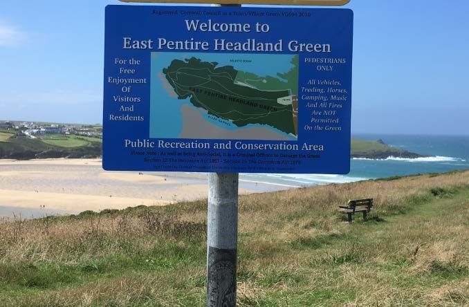
Our proposed route via the Trenance footbridge provides the most continuous route for the
walker being available for the greatest time of the three potential river crossing points (9 hours
during each tide). The footbridge to Penpol is only accessible for 6 hours during each tide. We
acknowledge that the proposed route provides estuary views while the footbridge leading to
Penpol creek has excellent views out to sea.

The proposed route also offers the most flexibility for the walker, passing close to the crossing
points at the seasonal Fernpit Ferry and the Penpol footbridge en route to the Trenance
footbridge a further 1.5km upstream. The proposed interpretation boards and signage will
provide walkers with the relevant information to select the most appropriate of these crossing
points according to the time of year and state of the tide.

In terms of a potential alternative route, this would come into use when the ‘ordinary’ route of
the coast path is unavailable and is designed to guarantee an unbroken onward journey. The
suggestion from CCAF to align the ordinary route via the footbridge towards Penpol and have
an alternative route via the Trenance footbridge, both of which are affected by tidal action,
would fail in the key objective of ensuring a continuous route. The legislation allows for only
one alternative route and therefore the proposed alternative high tide route via Trevemper is
the only valid option.

The route across the Penpol footbridge follows a public right of way (Public Footpath numbers
411/19/2 and 402/9/1) and therefore will remain accessible and will continue to be maintained
by Cornwall Council.
Relevant appended documents (see Section 5): N/A

Representation number:                       MCA/NQP1/R/4/NQP1585

Organisation/ person making                  Cornwall Countryside Access Forum
representation:
Route section(s) specific to this            NQP-1-S060
representation:
Other reports within stretch to which        N/A
this representation also relates:
Representation in full

(Penpol Hill)
This amendment to the existing route takes the path off a road and provides intermittent estuary
views where none exist on the current line. The amendment is welcomed and supported.

Natural England’s comments
We welcome the positive engagement from Cornwall Countryside Access Forum during the
development of our proposals and the supportive comments expressed in their representation.

Relevant appended documents (see Section 5): N/A

                                                   5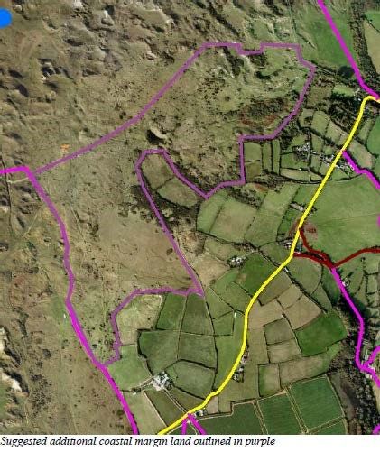
Representation number:                       MCA/NQP1/R/5/NQP1585

Organisation/ person making                  Cornwall Countryside Access Forum
representation:
Route section(s) specific to this            NQP-1-S109 and NQP-1-S110
representation:
Other reports within stretch to which        N/A
this representation also relates:
Representation in full

(Holywell Bay)
It is acknowledged that this length is more coastal and more direct than the existing route.
However, the existing route passes a number of facilities, including pub, shop and toilets, that
walkers will not have encountered for several miles in both directions (as well as buses for
access). There is no requirement under the Approved Scheme for the route to be the shortest
available when other benefits to walkers are thereby lost. Indeed, the Scheme indicates that
where there are existing public facilities it will be considered whether the proposals can make
positive links with these. In this case, the current route already does so and the proposal
removes such a link. It is therefore suggested that the current route be retained, for the
benefit of walkers and businesses alike; the proposed direct route could be signed as a
possible option, but omitting any facilities.
Natural England’s comments

The current South West Coast Path moves inland through the village of Holywell for a total of
around 600m, passing behind properties and hedges providing limited sea views at the
eastern end of the route.

The route included in our proposals cuts directly across the dunes seaward of the village,
providing a more coastal experience, with good sea views. We feel that the village facilities
are limited, comprising public toilets and a pub (the rear of which can be seen from the
proposed route) and therefore an inland detour is not appropriate.

Our proposed route best fits the key principles of alignment set out in section 4.1 of the
Scheme. In particular:
   • the safety and convenience of those using the route;
   • the desirability of it adhering to the periphery of the coast and providing views of the
      sea.

The route via the village will continue to be signposted for visitors wishing to make use of
these facilities but will not form part of the England Coast Path.

Relevant appended documents (see Section 5): N/A

                                                   6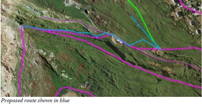
Representation number:                       MCA/NQP1/R/15/NQP1592

Organisation/ person making                  Ramblers Association, Cornwall
representation:
Route section(s) specific to this            NQP-1-S053 to NQP-1-S055
representation:
Other reports within stretch to which        N/A
this representation also relates:
Representation in full

(South Gannel)
We fully support the establishment of the ECP at this location. It gives a route which is closer
to the saline estuary than the South West Coast Path, which uses paths Crantock 12 and 14,
has good views of the estuary, is much less hilly and more direct. We recognise the need to
retain Crantock 12 and 14 as an alternative route for extreme tidal or weather conditions.

Natural England’s comments

We welcome the positive engagement from Ramblers Association during the development of
our proposals and the supportive comments expressed in their representation.

Relevant appended documents (see Section 5): N/A

Representation number:                       MCA/NQP1/R/16/NQP1592

Organisation/ person making                  Ramblers Association, Cornwall
representation:
Route section(s) specific to this            NQP-1-S060
representation:
Other reports within stretch to which        N/A
this representation also relates:
Representation in full

(Penpol Hill)
We fully support the rerouting of the path to use the south end of public footpath Crantock 8/3.
The revised line will be more direct than the SWCP route, less hilly and nearer the sea.
Natural England’s comments

We welcome the positive engagement from Ramblers Association during the development of
our proposals and the supportive comments expressed in their representation.

Relevant appended documents (see Section 5): N/A

                                                   7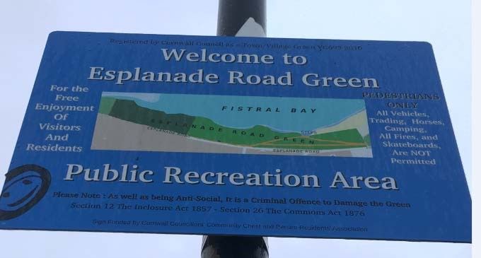
Representation number:                       MCA/NQP1/R/17/NQP1592

Organisation/ person making                  Ramblers Association, Cornwall
representation:
Route section(s) specific to this            NQP-8-S102 to NQP-8-S110
representation:
Other reports within stretch to which        N/A
this representation also relates:
Representation in full

We strongly support the proposal to include designated coastal margin landward of the path at
Holywell Bay. The Towans so designated are very much a feature of the marine margin and
have mostly been subject to unrestricted public access on foot for as long as anyone can
remember. As far as we are aware, public access on foot over a long period of time has not
caused significant damage to the SSSI. Security of the right to roam in the future would be
assured by the proposal.

We support the new route proposed for the ECP NQP-1-S110. It is more direct that the South
West Coast Path route, is entirely vehicle free and has more of a coastal feel than the present
SWCP. For those walkers wishing to take advantage of the facilities further inland, the present
SWCP route is likely to continue to be available because of public rights of way, Countryside
and Rights of Way access rights, coastal margin rights or permission of the landowner,
thought to be the National Trust.
Natural England’s comments

We welcome the positive engagement from Ramblers Association, Cornwall during the
development of our proposals and the supportive comments expressed in their representation.

The route via the village will continue to be signposted for visitors wishing to make use of
these facilities but will not form part of the England Coast Path.

Relevant appended documents (see Section 5): N/A

Representation number:                             MCA/NQP2/R/1/NQP1585

Organisation/ person making                        Cornwall Countryside Access Forum
representation:
Route section(s) specific to this                  NQP-2-S071 to NQP-2-S073
representation:
Other reports within stretch to which this         N/A
representation also relates:
Representation in full

                                                   8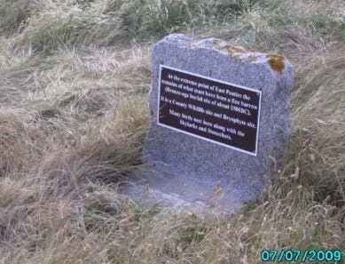
The current route at this point is convoluted and gives no sea views; the proposed more
seaward route is more logical, passes closer to Trevaunance Cove and maintains sea views.
This more seaward line is welcomed and supported.

Natural England’s comments

We welcome the positive engagement from Cornwall Countryside Access Forum during the
development of our proposals and the supportive comments expressed in their
representation.

Relevant appended documents (see Section 5): N/A

Representation number:                            MCA/NQP2/R/3/NQP1592

Organisation/ person making                       Ramblers Association, Cornwall
representation:
Route section(s) specific to this                 Map NQP 2h. Coastal margin landward of
representation:                                   route sections NQP-2-S020 to NQP-2-S025.

Other reports within stretch to which this        N/A
representation also relates:
Representation in full

(Penhale Towans)
We strongly support the inclusion of the coastal margin landward of the trail shown on map
2h. The land is certainly coastal in character and is mainly sand dunes. There has been public
access to much of the non-military land for a very long period and formalisation would be
helpful in preserving access for the future. However we believe that adjoining land of identical
character should also be designated as coastal margin, as shown on the aerial photograph
below and located at OS grid reference SW774563. The eastern and southern boundaries of
the additional land are much clearer on the ground than the boundaries on the proposals map,
being Cornish hedges enclosing agricultural land to the east and south.
Natural England’s comments

                                                  9
We welcome the positive engagement from Ramblers Association, Cornwall during the
development of our proposals and the supportive comments expressed in their representation.

In order to define the extent of the dunes, and consequently the extent of the default landward
coastal margin, we use a variety of data including site visits, aerial photography, Ordnance
Survey maps and the Priority Habitats Inventory (a publically available habitat dataset). In this
area the extent of the dune system was not clear and the evidence suggested that it did not
consistently extend inland as far as the various Cornish hedges mentioned in the
representation.

As the extent of the dune system in the Penhale area is unclear we chose to map the
landward extent of the coastal margin as far as the public right of way. We feel that the public
footpath provides a recognisable feature to mark the landward boundary of the coastal margin
and gives clarity on the ground. As a result the extent of the landward margin also closely
reflects the dune area as depicted by the Ordnance Survey on their map products.

Relevant appended documents (see section 5):

5B: Aerial photograph showing recommended revision of boundary.

Representation number:                            MCA/NQP5/R/1/NQP1585

Organisation/ person making                       Cornwall Countryside Access Forum
representation:
Route section(s) specific to this                 NQP-5-S003 and NQP-5-S004
representation:
Other reports within stretch to which this        N/A
representation also relates:
Representation in full

(Hor Point)
There are currently two parallel walked paths at this location. The existing formal route is the
inland one, and the proposal is to use the more seaward one. This route has more and better
sea views, and passes the end of the headland at Hor Point, an atmospheric location. This
line is therefore welcomed, although it is noted that it is a marginally more rugged route,
which may require some lengths of surface improvements, not highlighted in the report.
Natural England’s comments

We welcome the positive engagement from Cornwall Countryside Access Forum and the
South West Coast Path Association during the development of our proposals and the
supportive comments expressed in their representation.

We did not identify the need for any path improvements in this area during the preparation of
the proposals, however this will be reviewed during the implementation phase.
Relevant appended documents (see Section 5): N/A

                                                  10
Representation number: MCA/NQP5/R/2/NQP1585
Organisation/ person making Cornwall Countryside Access Forum
representation:
Route section(s) specific to this NQP-5-S006 (west end) and NQP-5-S007
representation:
Other reports within stretch to which this N/A
representation also relates:
Representation in full
(Pen Enys Point)
The current, and proposed, route cuts across the neck of the headland of Pen Enys Point. An
unofficial path has become established over Access Land which goes around the seaward
side of the headland, keeping closer to the coast and maintaining sea views. The layout is
such that walking east-west most walkers assume the coastal route to be the official line.
Given this, its better environment and the sea views, and reflecting the proposal to use the
seaward route at Hor Point headland a little to the east (route sections NQP-5 S003 and
NQP-5-S004, same map), it is suggested that the seaward route round Pen Enys Point be
used, leaving the current route available as an option.
Natural England’s comments
The existing South West Coast Path (SWCP) route at Pen Enys Point uses a public footpath,
and as stated in the representation takes a direct route across the neck of the Point.
Section 4.3.2 of the Coastal Access Scheme states: ‘People using the trail should not have to
follow an indented coastline slavishly. The trail needs in general to be close to the sea and to
offer sea views but also needs to enable people to make reasonable progress if their key aim
is an onward walk round the coast.’
In addition, where there is a public right of way (PRoW) which provides good sea views and a
coastal feel we will usually align the ECP along this line unless there are compelling reasons
to create a more seaward route. On the neighbouring headland (Hor Point) our proposed
route follows a public footpath seaward of the existing SWCP route for the majority of the
length. There are no seaward PRoWs at Pen Enys Point.
We do not feel that there is a marked benefit for the walker from aligning the route over the
Pen Enys headland, particularly as there are far reaching sea views from the route of the
SWCP which follows a PRoW.
The Pen Enys headland falls within the coastal margin and will therefore be accessible to
walkers as part of the seaward spreading room.
Relevant appended documents (see Section 5): N/A
11Representation number: MCA/NQP6/R/1/NQP1585
Organisation/ person making Cornwall Countryside Access Forum
representation:
Route section(s) specific to this NQP-6-S045 to NQP-6-S049
representation:
Other reports within stretch to which this N/A
representation also relates:
Representation in full
(Cape Cornwall)
The proposed route gives outstanding views and an excellent cliff environment to be
experienced. It is a better route than the current formal route and does, indeed, follow the
route previously informally agreed with the National Trust. The route is welcomed and
supported, but it is noted that it will require careful waymarking, which has been a problem
here in the past.
Natural England’s comments
We welcome the positive engagement from Cornwall Countryside Access Forum and the
South West Coast Path Association during the development of our proposals and the
supportive comments expressed in their representation.
Natural England will work with the Access Authority and National Trust to ensure that the
route is clearly waymarked.
Relevant appended documents (see Section 5): N/A
Representation number: MCA/NQP6/R/2/NQP1585
Organisation/ person making Cornwall Countryside Access Forum
representation:
Route section(s) specific to this NQP-6-S060 to NQP-6-S062
representation:
Other reports within stretch to which this N/A
representation also relates:
Representation in full.
12(Cot Valley)
The current SWCP route here diverts slightly inland to pass the ruins of Wheal Rose mine,
then uses a path parallel to and a little above the road down the Cot Valley to Porth Nanven.
The proposal is to descend more directly to the road, omitting Wheal Rose, and to follow the
road to Porth Nanven.
It is claimed there are advantages in that (a) this route is more seaward, (b) gives good views
and (c) allows the opportunity to visit Porth Nanven. However, (a) the road route is no nearer
the sea, although it does not divert inland to Wheal Rose – this is not necessarily an
advantage, in avoiding an interesting site of industrial archaeology; (b) the road route is lower
than the current route, meaning the views are not as good, and the route has to be shared
with traffic – while not busy, avoidance of such sharing is nevertheless an advantage; (c)
Porth Nanven is easily accessible from the current route.
Given these factors, the current route is to be preferred over the proposed route.
Natural England’s comments
In relation to the trail, Natural England is required by section 297(2) of the 2009 Act to have
specific regard to the desirability of it adhering to the periphery of the coast and providing
views of the sea. In our view, our proposal better meets this criteria than the existing line of
the SWCP.
The South West Coast Path (SWCP) in this location passes an additional 200m inland from
the route set out in our proposals and does not feel particularly coastal. We acknowledge that
Wheal Rose is a point of interest for some and therefore the route passing this site will be
signed for walkers who wish to divert inland and see the site.
Our proposed route takes walkers close to the main access point to the cove at Porth
Nanven, which we feel is an advantage due to the limited access to beaches and coves along
this part of the Cornish coast. We recognise that the cove can also be seen and accessed by
taking paths off the existing higher SWCP route.
With regard to the use of the road for part of the route, the adjacent verge will be cleared to
remove the need to walk on the road, which as stated in the representation is not busy.
Relevant appended documents (see Section 5): N/A
Representation number: MCA/NQP6/R/5/NQP1592
Organisation/ person making Ramblers Association, Cornwall
representation:
Route section(s) specific to this NQP-6-S061 to NQP-6-S062
representation:
13Other reports within stretch to which this N/A
representation also relates:
Representation in full
There are at least three possible routes at the Cot Valley:
1. The route used by the South West Coast Path
This is mostly off road, fairly pleasant and passes interesting remains of mining but is very
indirect and further inland than is desirable.
2. The route proposed as the England Coast Path
This is more direct and further to seaward than the SWCP but a longer proportion is on a
minor road and there is a severe gradient south of Porth Nanven.
3. A variation on 2 following public footpath 114/96 diagonally up the valley side
The route proposed by the Ramblers is shown on the aerial photograph below. It is the most
direct route of the three, is mostly off road and avoids the severe gradient south of Porth
Nanven.
Porth Nanven is within the coastal margin for all of these routes so can easily be visited if
desired.
Natural England’s comments
We agree that the route suggested by Ramblers Association is another possible option in this
area which would meet many of the criteria set out in the Coastal Access Scheme.
Our proposed route takes walkers close to the main access point to the cove at Porth
Nanven, which we feel is an advantage due to the limited access to beaches and coves along
this part of the Cornish coast. We recognise that the cove can also be seen and accessed
from other more landward paths in the area.
With regard to the use of the road for part of the route, the adjacent verge will be cleared to
remove the need to walk on the road.
The route put forward by Ramblers Association follows a public right of way and will remain
available for walkers to use along with a large area of landward coastal margin.
Relevant appended documents (see section 5):
6C - Aerial photograph showing route proposed by Ramblers
4. Summary of ‘other’ representations, and Natural England’s comments on them
Representations containing similar or identical points
Representation number: Organisation/ person making representation:
MCA/NQPStretch/R/2/NQP1580 [REDACTED]
14MCA/NQPStretch/R/3/NQP1583 [REDACTED]
MCA/NQPStretch/R/5/NQP1586 [REDACTED]
MCA/NQPStretch/R/6/NQP1589 [REDACTED]
MCA/NQPStretch/R/8/NQP1594 [REDACTED]
Name of site: Whole stretch
Report map reference: All
Route sections on or adjacent to the Whole stretch
land:
Other reports within stretch to which NQP1 to NQP8
this representation also relates:
Summary of point:
The respondents are concerned about reported plans to widen the coast path to 4 metres and
promote access to cyclists and horse riders.
Natural England’s comment:
There are no plans to physically widen the coast path to four metres on any part of this stretch
of coast. The legislation allows for the path to be up to four metres total width, however in
practice we have worked with the walked line of the existing South West Coast Path and
topography of the land. Where possible we specify the boundary of the coastal margin on the
landward side and therefore make clear the extent of people’s access rights, for example this
might be a boundary fence or hedge close to the route, and this is very often within two
metres of the walked path. Where we are not able to do this, because there is no suitable
physical feature, the access rights would extend to two metres on the landward side of the
trail by default, however there will not be any physical widening or resurfacing of the walked
path.
Part 9 of the Marine and Coastal Access Act 2009 aims to improve public access to, and
enjoyment of, the English coastline by creating clear and consistent public rights along the
English coast for open-air recreation on foot. Our proposals do not create any additional rights
of access for cyclists or horse-riders above those that already exist.
Relevant appended documents (see Section 5): N/A
Representations containing similar or identical points
Representation number: Organisation/ person making representation:
15MCA/NQP1/R/2/NQP1578 [REDACTED]
MCA/ NQP1/R/11/NQP1591 South West Coast Path Association
Name of site: Gannel estuary/Penpol footbridge
Report map reference: NQP 1b, NQP 1c
Route sections on or adjacent to the NQP-1-S037 to NQP-1-S045
land:
Other reports within stretch to which N/A
this representation also relates
Summary of representation:
Disagrees with the proposed route via the Trenance footbridge for a number of reasons:
• The proposed route takes walkers away from the most tranquil and beautiful part of the
estuary
• Coastal views are obscured
• Concerned about funding and maintenance issues if this route is not designated as the
ECP which will lead to safety issues
• The footbridge to Penpol creek is the preferred route for the England Coast Path and
the Trenance footbridge could form alternative route
Natural England’s comment:
The proposed route takes the most seaward line along the northern bank of the Gannel; there
is no safe route along the foreshore on the northern side of the river due to the unpredictable
nature of the tidal currents in this area. There is also no suitable access point to the foreshore
in the Pentire headland area when walking west to east. We acknowledge that there are some
places along the route where coastal views are limited or obscured. These areas are mostly
on the residential streets to the west of the footbridge leading to Penpol. It is also recognised
that the proposed route provides estuary views while the footbridge leading to Penpol Penpol
creek has views out to sea.
Our proposed route via the Trenance footbridge provides the most continuous route for the
walker being available for the greatest time of the three potential river crossing points (9 hours
during each tide). The footbridge to Penpol is only accessible for 6 hours during each tide.
The proposed route also offers the most flexibility for the walker, passing close to the crossing
points at the Fernpit Ferry and the Penpol footbridge en route to the Trenance footbridge a
further 1.5km upstream. The proposed interpretation boards and signage will provide walkers
with the relevant information to select the most appropriate of these crossing points according
to the time of year and state of the tide.
In terms of a potential alternative route, this would come into use when the ‘ordinary’ route of
the coast path is unavailable and is designed to guarantee an unbroken onward journey. The
suggestion to align the ordinary route via the footbridge towards Penpol and have an
alternative route via the Trenance footbridge, both of which are affected by tidal action, would
fail in the key objective of ensuring a continuous route. The legislation allows for only one
16alternative route and therefore the proposed alternative high tide route via Trevemper is the
only valid option.
The route across the Penpol footbridge follows a public right of way (Public Footpath numbers
411/19/2 and 402/9/1) and therefore will remain accessible and will continue to be maintained
by Cornwall Council.
Relevant appended documents (see Section 5): N/A
Representations containing similar or identical points
Representation number: Organisation/ person making representation:
MCA/NQP1/R/6/NQP1588 Pentire Residents Association
MCA/NQP1/R/7/NQP1582 East Pentire Action Group
MCA/NQP1/R/8/NQP1582 East Pentire Action Group
MCA/NQP1/R/9/NQP1590 Pentire Esplanade Project
MCA/NQP1/R/19/NQP1582 East Pentire Action Group
Name of site: Esplanade and Pentire Point East
Report map reference: NQP 1b
Route sections on or adjacent to the NQP-1-S031 to NQP-1-S036
land:
Other reports within stretch to which N/A
this representation also relates
17Summary of point:
The proposals in this area of Newquay affect two Registered Town or Village Greens
Esplanade Road Green (VG693) and Pentire Head (VG694) and will interfere with the use of
the Greens by residents of the area by increasing pedestrian access across the greens.
The Acts of Parliament (Section 12 of the Inclosure Act 1857 and Section 29 of the Commons
Act 1876 apply) and existing case law protecting Village Greens are clear and restrict legal
access to residents of the neighbourhood thus excluding open access.
Section 12 of the Inclosure Act 1857 makes it a criminal offence to:
• wilfully cause injury or damage to any fence on a green;
• wilfully take any cattle or other animals onto a green without lawful authority;
• wilfully lay any manure, soil, ashes, rubbish or other material on a green;
• undertake any act which causes injury to the green (e.g. digging turf); or
• undertake any act which interrupts the use or enjoyment of a green as a place of
exercise and recreation (e.g. fencing a green so as to prevent access).
Section 29 of the Commons Act 1876 makes it a public nuisance to:
• encroach on a green (e.g. extending the boundary of an abutting property so as to
exclude people from that area);
• enclose a green (i.e. by fencing it in, whether or not the effect is to exclude public
access);
The respondents suggest that both of the highlighted passages of text above could be
relevant if the coastal paths, as proposed, were implemented. The proposed designated
public coastal access path and other alterations would be considered a disturbance and be
contrary to the Greens legislation. The owner of the land cannot over-ride these conditions nor
grant permission for others to use the Greens even if there is established informal access.
The Gov.uk website clearly states that The Right to Roam does not apply to Registered Town
and Village Greens. This means that the proposed Coastal Access provisions cannot apply to
the Registered Greens. www.gov.uk/common-land-village-greens.
An inevitable effect of these proposals would be increased public access to the Greens and
thus wear and tear to the existing paths, or even the creation of new paths. These proposals
will conflict with the current village green residents’ rights and affect their ability to use the
Greens for recreation freely.
They do not accept that the proposed coastal paths and the additional coastal margin can
legally be permitted on a Registered Town or Village Green and therefore they would like our
proposals to be refused.
18Natural England’s comment:
In this area Natural England is proposing to align the coast path through two open areas in
west Newquay which are registered as village greens. The recreational rights over greens flow
from their registration as a green and only apply to people living in the locality.
Where a village green falls in the coastal margin, any new coastal access rights exist
alongside the village green rights, the former being for the general public for ‘open-air
recreation’ on foot, and the latter for local people (for all ‘lawful sports and pastimes’). The
breadth of the latter rights is such that local residents would remain able to use the land for a
wider variety of recreational activities then the general public, whose rights will be limited by
the ‘General Restrictions’ at Schedule 2 to the Countryside and Rights of Way Act 2000
(CROW Act). Any new coastal access rights therefore do not in any way replace or displace
the existing local rights.
The coastal access legislation states that all land between the coast path and mean low water
automatically becomes coastal margin, giving a public right of access on foot to this land
unless it falls under one of the ‘excepted land’ categories at Schedule 1 to CROW, or the right
is restricted or excluded by direction. In addition, with the permission of the landowner,
Cornwall Council, land to the landward side of the proposed new route at Esplanade Road
and Pentire Point East will also be included in the coastal margin. This decision was made as
there is already a pattern of informal access in these areas and they were keen to benefit from
the provision for a reduced landowner/occupier liability associated with the coastal access
legislation.
The key issue raised in the representations is the assertion that our proposals for coastal
access constitute an offence under section 12 of the Inclosure Act 1857 or a public nuisance
under Section 29 of the Commons Act 1876.
Creation of a coast path and associated coastal margin in these areas will not interrupt local
people’s use or enjoyment of the green as a place of exercise and recreation and therefore
does not breach section 12 of the 1857 Act. Neither is anything being proposed here that
would constitute for the purposes of section 29 of the 1876 Act ‘encroachment on or inclosure
of [the green]’ or ‘any erection thereon or disturbance or interference with or occupation of the
soil thereof, which is made otherwise than with a view to the better enjoyment of [the green]’.
There is nothing in either section that prevents the creation of additional access rights over the
same land, so long as nothing in the way that is done falls foul of these very specific offence
and public nuisance provisions.
The Esplanade and Pentire Point East are currently publicly accessible to local residents, as
village greens. There is also a well-established pattern of informal access at both sites and it
is likely that visitors to the area also access these spaces. This typically happens in practice
on village greens. Signs are in place on both sites stating that the areas are ‘for the free
enjoyment of visitors and residents’, indicating that visitors are also welcome to access and
enjoy these areas.
In pointing out that the generic right to roam over registered commons introduced under the
CROW Act does not apply on registered greens, the Gov.UK text quoted in the representation
is merely making the point that CROW did not create any such ‘national’ right to roam over
greens, as a class of land that is often confused with commons. This webpage is correctly
highlighting that commons and village greens are legally distinct, and greens are not within the
19scope of the original CROW rights over mapped areas of ‘open country’ (mountain, moor,
heath and down) or registered common land.
In terms of the works required for Coastal Access purposes at The Esplanade and Pentire
Point East, the proposed works are minor and de minimis. They comprise:
• Placement of waymarker posts at various points along each route (two at the
Esplanade and five at Pentire Point East)
• Some limited scrub clearance and cutting in of a path on the coastal slope along the
western end of the Esplanade along the line of the existing narrow walked path. Note –
please see our comments in the table immediately below in relation to representations
citing safety issues at this location.
• Repair and installation of timber steps at the far west of the Esplanade close to where it
meets the road to Lewinnick Lodge. Note – please see our comments in the table
below in relation to representations citing safety issues at this location.
• Limited scrub clearance alongside the road to Lewinnick Lodge along the line of the
existing narrow walked path on the East Pentire Headland.
Our proposals do not include any resurfacing works and no other path infrastructure is
planned for these areas.
Defra’s guidance on the management and protection of village greens states: ‘If the above
provisions were to be interpreted strictly, an act which causes any injury to a green would
appear to be an offence under section 12 of the 1857 Act and any disturbance or interference
with the soil of the green (other than for the purpose of better enjoyment of the green) would
technically be deemed a public nuisance under section 29 of the 1876 Act. However, in
Defra’s view, in considering whether or not any given development or action contravenes
either or both of these statutes a court is likely to be concerned with whether material harm
has been caused to a green and whether there has been interference with the public’s
recreational enjoyment.’
As above, we do not consider that these works would interfere with the ability of local
residents to access and enjoy the Greens and therefore do not contravene section 12 of the
Inclosure Act 1857 or Section 29 of the Commons Act 1876.
20Relevant appended documents (see Section 5):
• 5D - MCA/NQP1/R/7/NQP1582 - East Pentire Action Group - Village Green
Registration map - Pentire Head
• 5E - MCA/NQP1/R/7/NQP1582 - East Pentire Action Group - Map showing preferred
route at Pentire Head
• 5F - MCA/NQP1/R/7/NQP1582 - East Pentire Action Group - Photos x 10 of East
Pentire headland
• 5G - MCA/NQP1/R/8/NQP1582 - East Pentire Action Group - Village Green
Registration map - Esplanade
• 5H - MCA/NQP1/R/8/NQP1582 - East Pentire Action Group - Photos x 12 of Esplanade
Green
• 5I - MCA/NQP1/R/19/NQP1582 - East Pentire Action Group - Photo showing preferred
route at The Esplanade
• 5J - MCA/NQP1/R/19/NQP1582 - East Pentire Action Group - Email chain from Natural
England dated 14 August 2019
• 5K - MCA/NQP1/R/19/NQP1582 - Photos provided by Natural England of signs on East
Pentire and Esplanade greens
Representations containing similar or identical points
Representation number: Organisation/ person making representation:
MCA/NQP1/R/6/NQP1588 Pentire Residents Association
MCA/NQP1/R/14/NQP0818 [REDACTED]
MCA/NQP1/R/18/NQP1593 Newquay Town Council
Name of site: Esplanade, Newquay
Report map reference: NQP 1b
Route sections on or adjacent to the NQP-1-S031 and NQP-1-S032
land:
Other reports within stretch to which N/A
this representation also relates
Summary of point:
The proposed new route seaward of Esplanade Road is precipitous. It is very dangerous in
wet or windy weather and at other times is only suitable for the extremely fit with a good head
for heights.
21Natural England’s comment:
In light of the representations received from various parties we revisited the Esplanade area to
reassess the route with a particular view to looking at the safety of the route in wet and windy
conditions. Our conclusion is that even with the improvements proposed this route is likely to
be hazardous in inclement weather. Therefore, on balance, considering objective of
providing a safe and convenient route, we feel that a higher route along the road would be
preferable.
We recommend that the SoS approves a modified route which follows the current route of the
South West Coast Path along the surfaced paths at The Esplanade, the pavement on
Esplanade Road and the unadopted road leading to the Pentire Point East headland. This
recommended route is shown on the map in Section 6M, with sections NQP-1-S031 and NQP-
1-S032 amended to follow the line in blue. The recommended modified route sections would
not require the rollback provision.
Relevant appended documents (see Section 5):
• 5H - MCA/NQP1/R/8/NQP1582 - East Pentire Action Group - Photos x 12 of Esplanade
Green
• 5I - MCA/NQP1/R/19/NQP1582 - East Pentire Action Group - Photo showing preferred
route at The Esplanade
• 5L - MCA/NQP1/R/6/NQP1588 - Pentire Residents’ Association - Photos x 9 of
proposed route along The Esplanade
• 5M- MCA/NQP1/R/9/NQP1590 - Pentire Esplanade Project - Alternative new coastal
path proposal using pavement on Esplanade Road
• 5P - Map showing Natural England’s recommended modification to the proposed ECP
route at The Esplanade, Newquay
Representations containing similar or identical points
Representation number: Organisation/ person making representation:
MCA/NQP1/R/6/NQP1588 Pentire Residents Association
MCA/NQP1/R/8/NQP1582 East Pentire Action Group
Name of site: Esplanade, Newquay
Report map reference: NQP 1b
Route sections on or adjacent to the NQP-1-S031 and NQP-1-S032
land:
Other reports within stretch to which N/A
this representation also relates
22Summary of point:
Coastal views are better from the existing South West Coast Path route along the road.
Natural England’s comment:
We feel that the coastal views from the proposed route and the road are equally good.
Note - Please also see our comments in the table immediately above regarding the safety
concerns raised in relation to this route.
Relevant appended documents (see Section 5): N/A
Representations containing similar or identical points
Representation number: Organisation/ person making representation:
MCA/NQP1/R/7/NQP1582 East Pentire Action Group
MCA/NQP1/R/8/NQP1582 East Pentire Action Group
MCA/NQP1/R/9/NQP1590 Pentire Esplanade Project
MCA/NQP1/R/19/NQP1582 East Pentire Action Group
Name of site: Esplanade and Pentire Point East
Report map reference: NQP 1b
Route sections on or adjacent to the NQP-1-S031 to NQP-1-S036
land:
Other reports within stretch to which N/A
this representation also relates
23Summary of point:
Points quoted from the representations as below:
‘The areas claimed as Coastal Strip Roll Back appear to be extremely and unnecessarily
large.’
On the Pentire Point East headland ‘the Headland roll-back area is about half of the size of
the Headland and together with the Coastal Margin proposed almost comprise the area of
the Registered Greens 16.3 Hectares or 40.27 Acres. This should be considered to be
excessive and unnecessary for a Coastal Path - no matter what other interests may approve.’
At the Esplanade ‘the cliffs are relatively stable and any coastal erosion is negligible.’
‘The stated reasons for the extremely large areas for roll-back do not appear to be valid, in
that, the area is considered geologically stable and the existing land paths readily accessible.
The areas as drawn should be considerably reduced after consultation with professional
Engineering Geologists.’
‘The large areas proposed for statutory inclusion as Coastal Margin similarly are not was
intended within the National Parks and Access to the Countryside Acts 1949.’
Natural England’s comment:
There appears to be some confusion in the representations in relation to the distinction
between coastal margin and rollback.
Coastal margin
Under the coastal access legislation all land between the trail and the low water mark
automatically falls into the coastal margin. This happens as an automatic legislative
consequence of the position of the trail rather than a specific proposal made by Natural
England.
Any additional coastal margin landward of the trail is proposed where the landowner, in this
case Cornwall Council, agrees that there may be a recreational benefit and also agrees to its
inclusion. This also allows these wider areas to benefit from the uniquely low level of
owner/occupier liability.
Rollback
Rollback has been proposed on sections of the trail where evidence suggests that erosion or
other types of coastal change may impact on the line of the coast path (see section 6d of the
Newquay to Penzance Overview). Data provided by the Cornwall and Isles of Scilly Shoreline
Management Plan suggested that the proposed route at The Esplanade may be subject to
coastal erosion in the future and therefore these sections were flagged as potentially needing
to make use of the rollback provision at some point. The recommended modified route at this
location, as detailed in the table immediately above, would not require the rollback provision.
Rollback has not been proposed for the route sections on the Pentire Point East headland
(sections NQP-1-S034 to NQP-1-S036).
24The inland extent of any rollback is not specified in our proposals and is not in any way
reflected by the proposed landward coastal margin.
As detailed in our comments in relation to village greens we do not believe that either the
presence of coastal margin or the proposed rollback (at The Esplanade) would interfere with
local residents’ use and enjoyment of these areas.
Relevant appended documents (see Section 5): N/A
Representations containing similar or identical points
Representation number: Organisation/ person making representation:
MCA/NQP1/R/6/NQP1588 Pentire Residents Association
MCA/NQP1/R/8/NQP1582 East Pentire Action Group
MCA/NQP1/R/9/NQP1590 Pentire Esplanade Project
MCA/NQP1/R/14/NQP0818 [REDACTED]
MCA/NQP1/R/18/NQP1593 Newquay Town Council
MCA/NQP1/R/19/NQP1582 East Pentire Action Group
Name of site: Esplanade, Newquay
Report map reference: NQP 1b
Route sections on or adjacent to the NQP-1-S031 and NQP-1-S032
land:
Other reports within stretch to which N/A
this representation also relates
Summary of point:
The coast path should follow the existing surfaced disabled access paths at the eastern end
of the Esplanade rather than create an additional route. The paths are designed to minimise
the desire lines across the Green which result in visible damage to the grass of the Green.
Natural England’s comment:
Natural England will align the route of the coast path utilising the existing surfaced paths at
the eastern end of the Esplanade rather than create an additional route at this location.
25Relevant appended documents (see Section 5):
• 5M - MCA/NQP1/R/9/NQP1590 - Pentire Esplanade Project - Alternative new coastal
path proposal using pavement on Esplanade Road
• 5N - MCA/NQP1/R/9/NQP1590 - Pentire Esplanade Project - Photos x 6 of surfaced
paths at east end of The Esplanade
Representations containing similar or identical points
Representation number: Organisation/ person making representation:
MCA/NQP1/R/7/NQP1582 East Pentire Action Group
MCA/NQP1/R/8/NQP1582 East Pentire Action Group
MCA/NQP1/R/19/NQP1582 East Pentire Action Group
Name of site: Esplanade and Pentire Point East
Report map reference: NQP 1b
Route sections on or adjacent to the NQP-1-S031 to NQP-1-S036
land:
Other reports within stretch to which N/A
this representation also relates
Summary of point:
The proposals will have an adverse effect on flora, fauna, and archaeology.
The East Pentire headland is a County Wildlife Site and archaeological site and includes
skylark breeding grounds, stonechats, butterflies, other coastal birds, wild flowers and rare
bryophytes. The Esplanade area includes bird breeding grounds, butterflies, other coastal bird
habitats, and wild flowers. These would be adversely affected by increases in pedestrian
usage.
Natural England’s comment:
A full assessment of any potential impacts on wildlife and habitats was undertaken as part of
the preparation of our proposals. The results of this are detailed in the Nature Conservation
26Assessment which was published and publically available on gov.uk at the same time as the
proposals for Newquay to Penzance.
As stated on page 15 of the Overview document ´We also engaged with internal specialists
and relevant organisations locally - including Cornwall Wildlife Trust, Royal Society for the
Protection of Birds, Cornwall Seal Group and Cornwall Area of Outstanding Natural Beauty -
to consider any potential for impacts on key sensitive features.’
The proposed route in these areas uses existing walked lines and mown paths to avoid key
areas of habitat. With the existing pattern of informal access in this area we do not consider
that our proposals would have an impact on the species highlighted in the representation.
In terms of the archaeological interest on the East Pentire headland, Natural England attended
a site visit with a representative from Historic England to identify a route which would not
impact on the Scheduled Ancient Monuments.
Relevant appended documents (see Section 5): N/A
Representations containing similar or identical points
Representation number: Organisation/ person making representation:
MCA/NQP1/R/7/NQP1582 East Pentire Action Group
MCA/NQP1/R/19/NQP1582 East Pentire Action Group
Name of site: Pentire Point East
Report map reference: NQP 1b
Route sections on or adjacent to the NQP-1-S036
land:
Other reports within stretch to which N/A
this representation also relates
Summary of point:
On the southern part of the Pentire Point East headland there are existing small paths closer
to the coast which could be utilised.
Natural England’s comment:
The route around the headland was surveyed by Natural England and Cormac and considered
to be a suitable route for the coast path, utilising walked lines and existing mown strips, while
providing good coastal views. Under our proposals the existing small paths closer to the coast
would still be available to the public as part of the coastal margin.
27Relevant appended documents (see Section 5): N/A
Representations containing similar or identical points
Representation number: Organisation/ person making representation:
MCA/NQP1/R/14/NQP0818 [REDACTED]
MCA/NQP1/R/18/NQP1593 Newquay Town Council
Name of site: Trethellan Footbridge
Report map reference: NQP 1c
Route sections on or adjacent to the NQP-1-S042
land:
Other reports within stretch to which N/A
this representation also relates
Summary of point:
The ‘Penpol boardwalk’ is a misleading title - this is known locally as the Trethellan footbridge.
Natural England’s comment:
These representations refer to the low tidal footbridge from the northern side of the River
Gannel over the main channel leading towards Penpol. Natural England is aware that some
local signs refer to the ‘footbridge’ or ‘boardwalk’ to Penpol.
We thank the responders for this information and will in future refer to this as the Trethellan
footbridge.
Relevant appended documents (see Section 5): N/A
Representation number: MCA/NQPStretch/R/1/NQP1577
Organisation/ person making [REDACTED]
representation:
Name of site: Whole stretch
Report map reference: N/A
28Route sections on or adjacent to the N/A
land:
Other reports within stretch to which NQP1 to NQP8
this representation also relates
Summary of representation:
The coast path should not be renamed the ‘England Coast Path’ in Cornwall. Cornwall is
covered by the provisions of the Framework Convention for the protection of National
Minorities. The proposed name is in contravention of Article 5.1 of the Convention because it
imposes a false English identity, and thus fails to preserve the identity of the national Cornish
minority.
Natural England’s comment:
There is no intention to retitle the coast path within Cornwall. Page 6 of the Newquay to
Penzance stretch Overview Report states: ‘The 2009 Act refers to the continuous trail with its
associated margin and other access rights as being the ‘England Coast Path’. Where
appropriate we have used existing established coastal trail routes already known by local and
regional names, such as the South West Coast Path. It is recognised and welcomed that
other local established route names will continue to be used on the ground. Natural England
will continue to work closely with Cornwall Council and others in extending the use of Cornish
as appropriate on new or replacement signing.’
Relevant appended documents (see Section 5): N/A
Representation number: MCA/NQP1/R/7/NQP1582
Organisation/ person making East Pentire Action Group
representation:
Name of site: Pentire Point East
Report map reference: NQP 1b
Route sections on or adjacent to the NQP-1-S034
land:
Other reports within stretch to which N/A
this representation also relates
Summary of point:
The tarmac access road to Lewinnick Lodge to the north of NQP-1-S034 would be more
correct for the proposed path as it is nearer the coast and would not cause unnecessary
additional erosion of the currently lightly-used unmade foot-way inland.
29You can also read