DRAFT GENERAL MANAGEMENT PLAN / ENVIRONMENTAL IMPACT STATEMENT SUMMARY OF KEY EXCERPTS - OZARK NATIONAL SCENIC RIVERWAYS
←
→
Page content transcription
If your browser does not render page correctly, please read the page content below
Ozark National Scenic Riverways                         National Park Service
Missouri                                       U.S. Department of the Interior

                                  Draft General Management Plan /
                                  Environmental Impact Statement
                                  Summary of Key Excerpts
Ozark National Scenic Riverways                                                                         National Park Service
Draft General Management Plan /                                                               U.S. Department of the Interior
Wilderness Study / Environmental
Impact Statement

Dear Friends of Ozark National Scenic Riverways,
This document contains key excerpts from the Ozark National Scenic Riverways Draft General Management Plan / Wilderness
Study / Environmental Impact Statement (Draft GMP). The purpose of the key excerpts is to orient reviewers to important
portions of the document and to provide summary information regarding the Draft GMP. It is not a substitute for the GMP,
which has more specific and comprehensive information.
This packet contains a copy of the following sections of the Draft GMP:
     • Executive summary
     • Guide to this document
     • Table 2 – Land-Based Management Zones
     • Table 3 – River-Based Management Zones
     • Table 4 – Motorboat Horsepower Limit by Alternative
     • Table 5 – Recreation Activities by Management Zone
     • No-Action Map
     • Alternative A Map
     • Alternative B Map (NPS Preferred Alternative)
     • Alternative C Map
     • Table 13 – Summary of Key Differences among the Alternatives
The National Park Service values your continued interest and commitment to the future of Ozark National Scenic Riverways.
Thank you for your involvement.

Sincerely,

William N. Black
Superintendent

Ozark National Scenic Riverways | Attn: Superintendent
PO Box 490 Van Buren, MO 63965 | ph: 573.323.4236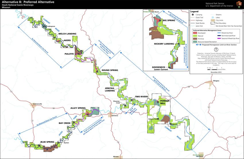
Ozark National Scenic Riverways                    National Park Service
Draft General Management Plan /          U.S. Department of the Interior
Wilderness Study / Environmental
Impact Statement

Dear Friends of Ozark National Scenic Riverways,
I am pleased to announce the release of the Draft General Management
Plan / Wilderness Study / Environmental Impact Statement (Draft GMP) for
Ozark National Scenic Riverways. The Draft GMP reflects many years of
work, and many of you have contributed important information for our
consideration in preparing the plan. Stakeholder groups, other agencies,
and the general public have all been valuable partners in this effort, and
we look forward to meeting with you and discussing the Draft GMP in the
coming months.
When completed, the GMP will assist National Park Service managers to
protect resources, provide appropriate visitor use, and carry out essential
management of the Riverways for at least the next 20 years. The goals and
strategies identified in the plan will help fulfill the mission of the National
Park Service and Ozark National Scenic Riverways. We believe the NPS
Preferred Alternative (identified and described in chapter 2 of the Draft
GMP) best achieves these objectives. It is anticipated that the Final GMP
and Record of Decision will be completed in 2014 and implementation of
the measures identified in the plan will then begin.
There are several opportunities for you to provide your comments and
suggestions on the plan over the next 60 days. You may attend and
provide comments at public meetings (see dates, locations and times on
this letter) submit input through the website listed below, or by mailing
your comments to the address listed below. Your views will be carefully
considered by NPS planners and managers.
The review period officially begins on November 8 and goes through
January 8. The Draft GMP is available for your review and comment at:
http://parkplanning.nps.gov/OZAR (then go to the “Open for Comment”
link). A limited number of paper copies and CDs of the plan are also
available upon request by contacting Ozark National Scenic Riverways at
the address or phone number listed below.
The National Park Service values your continued interest and
commitment to the future of Ozark National Scenic Riverways.
Thank you for your involvement.
Sincerely,

William N. Black     Ozark National Scenic Riverways | Attn: Superintendent
Superintendent       PO Box 490 Van Buren, MO 63965 | ph: 573.323.4236

Tues., Dec. 10, 2013
6-8 p.m. Draft GMP Open House | 8-9 p.m. Wilderness Hearing
Van Buren Youth & Community Center | ph: (573) 323-8958
Intersection of Business 60 & D Highway | Van Buren, MO 63965

Wed., Dec. 11, 2013
6-8 p.m. Draft GMP Open House | 8-9 p.m. Wilderness Hearing
Powder Valley Conservation Nature Center | ph: (314) 301-1500
11715 Cragwold Road | Kirkwood, MO 63122

Wed., Dec. 11, 2013
10 a.m.-12 p.m. Draft GMP Open House
Salem City Hall Auditorium | ph: (573) 729-4811
202 North Washington | Salem, MO 65560
EXECUTIVE SUMMARY
PURPOSE OF THE PLAN Riverways. Based on the purpose and
significance of the NPS Riverways, the
Ozark National Scenic Riverways (the NPS alternatives provide different ways to
Riverways, National Riverways, or the park manage resources and visitor use and
unit) was established as a unit of the improve facilities and infrastructure.
national park system by the U.S. Congress
in 1964. The first general management plan The four alternatives are the no-action
for the National Riverways was completed alternative (continuation of current
in 1984, and this plan served the park unit management) and three action alternatives,
well for many years. However, the 1984 designated alternative A, alternative B
plan is outdated and the NPS Riverways is (NPS preferred), and alternative C. The
now facing an increasing array of issues action alternatives include management
that require guidance through an updated, zones, which only apply to land areas for
approved general management plan. A new which the National Park Service has fee
plan is needed for the following reasons: title land ownership. Management zones
do not apply to private lands within park
Clearly define resource conditions boundaries, including private lands with
and visitor experiences to be overlaying scenic or conservation
achieved at Ozark National Scenic easements.
Riverways.
Provide a framework for National Additional actions and alternatives were
Park Service (NPS) managers to use considered and dismissed from further
when making decisions about how analysis. Dismissed actions and the
to best protect the NPS Riverways’ supporting rationale are included in
resources, provide a diverse range “Chapter 2: Alternatives, Including the
of visitor experience opportunities, Preferred Alternative.”
and manage visitor use, and what
kinds of facilities, if any, to develop
in the National Riverways. No-action Alternative
Ensure that this framework for The no-action alternative describes how
decision making has been Ozark National Scenic Riverways has been
developed in consultation with and would continue to be managed
interested stakeholders and without the implementation of an action
adopted by NPS leadership after alternative. It reflects current resource
adequate analysis of the benefits, conditions and trends, existing recreational
impacts, and economic costs of opportunities, types of development, and
alternative courses of action. levels of service. The no-action alternative
also describes ongoing management issues,
such as resource degradation and visitor
THE ALTERNATIVES conflicts. The primary purpose of the no-
action alternative is to establish a baseline
This Ozark National Scenic Riverways for determining the impacts of the action
Draft General Management Plan / alternatives.
Wilderness Study / Environmental Impact
Statement (general management plan) The no-action alternative is a description
presents four alternatives for the future of current management conditions rather
management of Ozark National Scenic than a reiteration of existing planning
documents for the National Riverways.
i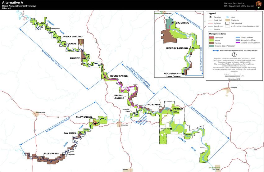
EXECUTIVE SUMMARY

The 1984 general management plan, 1989              approach to resource and visitor use
river use management plan, and 1992                 management. Specific management zones
statement for management all provide a              detailing acceptable resource conditions,
basis for understanding the current                 visitor experience and use levels, and
management approach.                                appropriate activities and development
                                                    would be applied to National Riverways
Under the no-action alternative, the                lands consistent with this concept.
National Park Service would continue to
maintain the Big Spring tract’s primitive,
natural character to maintain its wilderness        Alternative B (NPS Preferred)
eligibility.
                                                    Under this alternative, management would
                                                    enhance opportunities for visitors to
Alternative A                                       discover and learn about the natural
                                                    wonders and Ozark heritage of the
Under alternative A, management would               National Riverways, while maintaining a
focus on creating visitor experiences and           mix of traditional recreational and
providing resource conditions that help             commercial activities. Emphasis would be
visitors better understand the riverways of         placed on increasing opportunities for
the past, including traditional river               visitor education and connections to
recreation activities reminiscent of those          natural resources and cultural landscapes.
that occurred when the National
Riverways were established. Management              This alternative would focus on providing
would emphasize greater opportunities for           a balance of diverse recreational
traditional, nonmechanized forms of                 opportunities and visitor experiences along
recreation and visitor experiences that are         with increasing visitor education and
quieter, less crowded, and slower paced.            appreciation of natural and cultural
Management would also focus on                      resources of the park unit. For example, a
protecting natural resources and systems.           mix of private and guided traditional
Under this alternative, most of the Big             recreational activities like boating, floating,
Spring Wilderness Study Area would be               and horseback riding would occur under
recommended for wilderness designation.             this alternative. Additional trails and a
                                                    small learning center at a rehabilitated
Management would strive to provide more             Powder Mill would be developed to better
secluded visitor experiences and more               orient and inform visitors. Natural
awareness of, and opportunities for,                resources would be restored to more
historical cultural connections. Emphasis           natural conditions, while maintaining
would be placed on restoring natural                greater opportunities for visitor access
resources to more natural conditions and            than under alternative A. Most of the Big
limiting development. Visitor services and          Spring Wilderness Study Area would be
facilities would be retained only to provide        recommended for wilderness designation.
access for specific recreational activities
and administrative activities. For example,         This alternative would provide a
roads and trails that have been illegally           comprehensive NPS Riverways-wide
developed would be closed and                       approach to resource and visitor use
rehabilitated with native vegetation. Some          management. Specific management zones
commercial services may be limited to               detailing acceptable resource conditions,
achieve desired resource and visitor                visitor experience and use levels, and
experience conditions.                              appropriate activities and development
This alternative would provide a                    would be applied to NPS Riverways lands
comprehensive NPS Riverways-wide                    consistent with this concept.

                                               ii
Executive Summary
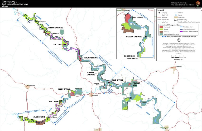
Alternative C This alternative would provide a
comprehensive NPS Riverways-wide
Under alternative C, management would approach to resource and visitor use
primarily seek to provide a diversity of management. Specific management zones
outdoor recreational opportunities and detailing acceptable resource conditions,
experiences while maintaining the highly visitor experience and use levels, and
scenic natural setting and cultural appropriate activities and development
resources. The National Riverways would would be applied to NPS Riverways lands
be managed to support higher levels and consistent with this concept.
diverse types of recreational opportunities,
with a focus on more intensive
management to ensure that excessive NEXT STEPS
impacts on resources or public safety
would not occur. In addition, land-based After the distribution of the Ozark
recreational opportunities would be National Scenic Riverways Draft General
increased. Management Plan / Wilderness Study /
Environmental Impact Statement, there will
Visitors would experience higher levels of be a 60-day public review and comment
social interaction with other visitors, period. Afterward, the National Park
especially during the peak season, which is Service planning team will evaluate
defined as March 15 through Labor Day. comments from other federal agencies,
Additional facilities such as campgrounds tribes, organizations, businesses, and
and trails would be developed to individuals regarding this draft plan. The
accommodate increased levels and National Park Service will then incorporate
different types of visitor use. appropriate changes and prepare a final
general management plan. The final plan
To support these recreational conditions, will include letters from governmental
there would be a higher tolerance for agencies, any substantive comments on the
resource impacts on more heavily used draft document, and NPS responses to
areas. Monitoring efforts would be those comments.
emphasized to track natural resource
conditions so unacceptable impacts from Following distribution of the final general
recreational activities did not occur. management plan and a 30-day no-action
Interpretive and education programs period, a record of decision approving a
would focus on expanding visitor final plan will be prepared for signature by
connection with natural and cultural the NPS regional director. The record of
resources while improving their knowledge decision documents the NPS selection of
of low-impact recreational uses. The goal an alternative for implementation. The
of such programs would be to encourage plan will then be implemented, depending
resource stewardship. Under this on funding and staffing. A record of
alternative, approximately half of the Big decision does not guarantee funds and staff
Spring Wilderness Study Area would be for implementing the approved plan.
recommended for wilderness designation.
iii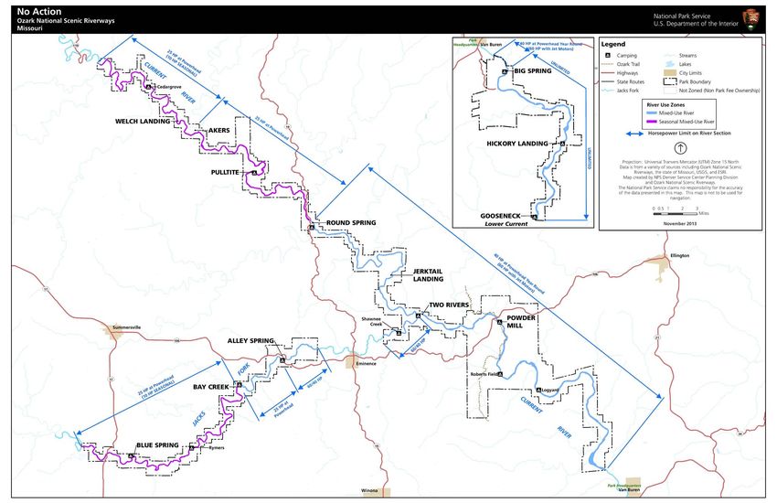
GUIDE TO THIS DOCUMENT

This Ozark National Scenic Riverways                 minimize or eliminate the impacts of some
Draft General Management Plan /                      proposed actions are described just before
Wilderness Study / Environmental Impact              the discussion of future studies and/or
Statement is organized in accordance with            implementation plans that would be
the Council on Environmental Quality’s               needed. The evaluation of the
implementing regulations for the National            environmentally preferable alternative is
Environmental Policy Act, the NPS                    followed by summary tables of the
Director’s Order 12: Conservation                    environmental consequences of
Planning, Environmental Impact Analysis,             implementing the alternative actions.
and Decision-making, and the NPS General
Management Planning Dynamic                          Chapter 3: Wilderness Study begins with
Sourcebook.                                          an explanation of how the study was
                                                     completed and a description and map of
Chapter 1: Introduction sets the                     the study area. This section explains the
framework for the document. It describes             wilderness eligibility process and how this
why the plan is being prepared and what              relates to areas of the National Riverways.
needs it addresses based on the Ozark                Public comments regarding wilderness
National Scenic Riverways’ legislated                designation are summarized in this
mission, its purpose, the significance of its        chapter. A comparison of alternatives
resources, special mandates and                      analyzed for the wilderness study is then
administrative commitments, servicewide              presented. The wilderness proposal
mandates and policies, and other planning            process is explained as well as how
efforts in the area.                                 managing for wilderness may affect
                                                     planning and management of services,
The chapter also details the planning                resources, and uses of the wilderness area.
opportunities and issues that were raised
during public scoping meetings and initial           Chapter 4: Affected Environment
planning team efforts. The alternatives              describes those areas and resources that
developed and presented in the next                  would be affected by implementing actions
chapter address these issues and concerns            in the various alternatives. Included are
to varying degrees. This chapter concludes           natural resources, cultural resources,
with a statement of the scope of the                 visitor use and experience, soundscapes,
environmental impact analysis, including             park operations, and the socioeconomic
what impact topics were retained or                  environment.
dismissed from detailed analysis and why.
                                                     Chapter 5: Environmental
Chapter 2: Alternatives, Including the               Consequences analyzes the impacts of
Preferred Alternative begins with an                 implementing the alternatives on topics
explanation of how the alternatives were             described in “Chapter 4: Affected
formulated and how the preferred                     Environment.” Methods that were used for
alternative was identified. A comparison of          assessing the impacts in terms of the
costs for implementing the alternatives is           locality, intensity, type, and duration of
included. The four alternatives (including           impacts are outlined at the beginning of the
continuation of current management) are              chapter.
then presented. Mitigation measures to

                                                xv
GUIDE TO THIS DOCUMENT

Chapter 6: Consultation and                         Chapter 7: Appendixes, References,
Coordination describes the history of               Preparers and Consultants presents
public and agency coordination during the           supporting information for the document.
planning effort and any future compliance
requirements. It also lists agencies and
organizations that will be receiving copies
of the document, and NPS responses to
comments received on the draft plan.

                                              xvi
Management Zones
TABLE 2. OZARK NATIONAL SCENIC RIVERWAYS LAND-BASED MANAGEMENT ZONES
Developed Resource-based recreation Natural Primitive
Zone concept Areas support moderate to high levels of development Areas support moderate levels of visitor use to accommodate Areas support the broader ecological integrity of the national Areas retain their wild, natural character.
and visitor services to accommodate concentrated visitor a wide range of recreational, educational, and interpretive riverways. Natural resources and processes would be preserved to
use and diverse recreational, educational, and interpretive opportunities. Natural processes would dominate and only low-impact maintain their pristine conditions and ecological integrity.
opportunities. Although some resource modifications could occur, natural and recreational activities would be allowed. Opportunities would be provided for visitors to experience
Most of the administrative facilities for operations and cultural resources would remain largely intact. Visitors would be immersed in nature with opportunities to backcountry challenges and solitude.
maintenance would be in this zone. enjoy solitude and natural sights and sounds.
Levels of Moderate to high levels of development to meet visitor use and Moderate levels of development for the purpose of directing Developments would be limited to those essential for resource Minimal development would be allowed for the protection of
development park administrative needs. visitor use, enhancing recreational opportunities, and protection, research, monitoring, and basic visitor services. natural resources and to allow for dispersed, low-impact visitor
protecting resources. use.
Visitor experience Visitors would have opportunities to better understand the Visitors would have opportunities to participate in a range of Visitors would encounter intact natural resources, features, and Visitors would be immersed in a primitive, wild setting with
riverways’ significant resources and values through a wide recreational, interpretive, and educational opportunities. systems for personal inspiration, education, and recreation. opportunities to experience backcountry challenges, solitude,
range of interpretive facilities and services, interact with other Visitors would experience a mostly natural setting where some Experiences could include opportunities for solitude, and self-reliance.
visitors and park staff, and recreate in an environment that is visitor services are available. contemplation, and self-reliance. Visitors would have a sense of remoteness, isolated from the
supported by a variety of visitor services. sights and sounds of other people.
Evidence of human use would be limited.
Visitors would experience a modified natural environment with
developed visitor facilities for orientation; day and overnight
use would concentrate most of the park’s visitors in these
areas. They also would have a high expectation for quality
services and facilities.
Visitor services Moderate to high level of visitor services could include one or Moderate levels of visitor services would be provided, such Low levels of visitor services would be provided, such as Directional signs would be provided at trailheads.
more of the following: orientation and interpretive programs, as orientation and interpretive programs, signs and wayside informational signs and wayside exhibits. Limited interpretive materials might be available to promote
signs, wayside exhibits, campgrounds, contact stations, exhibits, and commercial services if compatible with the desired safe and responsible recreation.
commercial operations, convenience stores, dining, and shuttle resource conditions and visitor experiences.
services.
Natural resource Natural resources would be managed to accommodate facilities Resources would be maintained in their natural condition, Ecological integrity would be maintained by preserving Natural systems and processes would function independent of
condition for NPS operations and concentrated visitor use. yet modified where necessary to provide distinct visitor and restoring natural resources and processes through an human intervention.
The effects of developments and visitor use on the natural opportunities and experiences. integrated natural resource management approach. Natural conditions would be restored when disturbed by
surroundings would be minimized through planning and Modifications would be aesthetically blended with the Emphasis would be placed on protecting and restoring human activity, but only if degraded sites are not expected to
design efforts. environment as much as possible. outstanding natural features and habitats for rare and recover in a timely manner without human intervention.
endangered species. No development would occur.
Cultural resource Cultural resources eligible for or listed in the National Register Same as Developed Same as Developed Same as Developed
condition of Historic Places would be protected and managed consistent
with NPS policies and the standards published by the secretary
of the interior.
All other cultural resources would be evaluated to determine
if they should be preserved, stabilized, restored, or left
unmaintained.
45CHAPTER 2: ALTERNATIVES, INCLUDING THE PREFERRED ALTERNATIVE
TABLE 3. OZARK NATIONAL SCENIC RIVERWAYS RIVER-BASED MANAGEMENT ZONES (INCLUDES RIVERS UP TO THE ORDINARY HIGH-WATER MARK)
Mixed-use Seasonal mixed-use Nonmotorized
Zone concept The river supports a mix of motorized and nonmotorized boating opportunities. The river supports a mix of nonmotorized and lower-horsepower motorized boating The river supports year-round, nonmotorized boating opportunities.
The natural setting would predominate, but the sights and sounds of human activity during the off-peak season, which occurs from after Labor Day through March 14. The Visitors would experience an unaltered river system where natural sights and sounds
would be prevalent. rest of the year, only nonmotorized boating would be allowed. would predominate, except during peak use when recreational activity would be
The natural setting would predominate, but the social setting would vary seasonally with more apparent.
the types of allowable activities and levels of use.
Levels of development Low to moderate levels of development would be provided to accommodate Same as Mixed-Use Low levels of development could be provided to accommodate launching and
launching and retrieving motorized and nonmotorized watercraft on the river. retrieving only nonmotorized watercraft on the river.
Locating new developments or improvements in the floodplain would be avoided Locating new development or improvements in the floodplain would be avoided.
where possible.
Visitor experience Visitors would have opportunities to engage in a diverse mix of motorized and Visitors would have the opportunity to float the river without the presence of motorized Visitors would have the opportunity to float the river without the presence of
nonmotorized boating experiences. boats during the peak season, which is defined as March 15 through Labor Day. motorized boats year-round.
During the off-season, visitors would have opportunities to engage in a mix of lower-
horsepower motorized and nonmotorized boating experiences.
Natural resource The natural resource conditions in the river corridor would be managed to ensure Same as Mixed-Use Same as Mixed-Use
condition that the free-flowing clear, clean water of the river was not degraded.
Cultural resource Cultural resources eligible for or listed in the National Register of Historic Places Same as Mixed-Use Same as Mixed-Use
condition would be protected and managed consistent with NPS policies and the standards
published by the secretary of the interior.
All other cultural resources would be evaluated to determine if they should be
preserved, stabilized, restored, or left unmaintained.
Cultural resources that are subject to bank erosion, slumping, subsidence, or other
natural deterioration would be stabilized using best management practices.
46CHAPTER 2: ALTERNATIVES, INCLUDING THE PREFERRED ALTERNATIVE
TABLE 4. MOTORBOAT HORSEPOWER (HP) LIMITS BY ALTERNATIVE
No-action Alternative B
Alternative A Alternative C
alternative (NPS preferred)
Peak Off-peak Off-peak Off-peak Off-peak
Peak season Peak season Peak season
season season season season season
Northern
boundary to 10 hp 25 hp No motorboats
Akers No motorboats
No motorboats
Akers to Pulltite
No
Pulltite to 25 hp 25 hp No 25 hp
25 hp motorboats
Current River
Round Spring motorboats
Round Spring to No
25 hp
Two Rivers motorboats
60/40 hp
Two Rivers to
60/40 hp
Van Buren
Van Buren to 60/40 hp
48
Big Spring 40 hp
Big Spring to No hp limits
southern No hp limits
boundary
Western
boundary to No motorboats
Rymers 10 hp 25 hp No motorboats
Rymers to No
Jacks Fork
25 hp
Bay Creek motorboats
Bay Creek to No motorboats
25 hp
Alley Spring No
25 hp 25 hp
Alley Spring to motorboats
60/40 hp
West Eminence
East Eminence to
60/40 hp 60/40 hp 60/40 hp
Two Rivers
General notes:
Peak season is defined as March 15 through Labor Day.
The designation of 60/40 assumes a regulation change. The color codes correspond to the river-based management zones described in table 3:
Mixed-use Seasonal mixed-use NonmotorizedTABLE 5. RECREATION ACTIVITIES BY MANAGEMENT ZONE
Land-based management zones River-based management zones
Activity Resource- Seasonal mixed-use
Developed based Natural Primitive Mixed-use river Nonmotorized river
river
recreation
Picnicking ● ● ● ● ● ● ●
Camping, amenities ● ●
provided
Camping, no amenities ● ●
Camping on gravel ● ● ● ● ● ● ●
bars1
Lodging/dining ●
Hiking ● ● ● ●
Horseback riding On designated trails At designated fords
Bicycling on roads ● ● ●
Bicycling on trails ● ● ●
49
Scenic viewing / ● ● ● ● ● ● ●
nature observation
Interpretive talks, ● ● ● ● ● ● ●
demonstrations
Hunting and trapping ● ● ● ● ● ●
Fishing (not in springs) ● ● ● ● ● ● ●
Caving Guided Guided Guided Guided
All terrain vehicle2 ●
Swimming 3
● ● ●
Canoeing, kayaking, ● ● ●
rafting, tubing
Motorboats year- Peak season: No
Management Zones
round. See table 4 for
Motorized boating motorboats. Off-peak No motorboats.
motorboat season 25 horsepower
horsepower limits by maximum.
alternative.
1 Camping on gravel bars accessed by vehicles would only be allowed in designated campsites.
2 All-terrain vehicle and utility terrain vehicles would only be allowed on designated county roads, in accordance with state law.
3 Swimming is not allowed in springs or spring branches.The No-action Alternative
Continuation of Current Management Practices
61Alternative A 67
Alternative B (NPS Preferred)

75
Alternative C

81
Summary of Key Differences Among the Alternatives

                                                                                                    TABLE 13. SUMMARY OF KEY DIFFERENCES AMONG THE ALTERNATIVES

     Topic                          No-action alternative                                                    Alternative A                                               Alternative B (NPS preferred)                                                Alternative C
Concept          The no-action alternative describes how Ozark National Scenic       Management would focus on creating visitor experiences and           Management would provide a high level of protection of                Management would primarily seek to provide a diversity of
                 Riverways has been and continues to be managed. It reflects         providing resource conditions that help visitors better              natural and cultural resources, while expanding ways for visitors     outdoor recreational opportunities and experiences while
                 current resource conditions and trends, existing recreational       understand the riverways of the past, including the traditional      to experience and learn about these resources in interesting and      maintaining the highly scenic natural setting and cultural
                 opportunities, types of development, and levels of service. The     river recreation activities reminiscent of those that occurred       enjoyable ways. Management would strive to improve visitors’          resources. Management would provide a diversity of river
                 primary purpose of describing the no-action alternative is to       when the National Riverways was established. Management              connection to the natural, cultural, and scenic elements of the       recreational opportunities and experiences similar to that
                 provide a baseline for comparing the other management               would emphasize greater opportunities for traditional,               National Riverways with the major goal of helping improve             provided in the no-action alternative. In addition,
                 alternatives.                                                       nonmechanized forms of recreation and visitor experiences that       visitor appreciation of its resources. Management would               management would offer land-based recreational
                                                                                     are quieter, less crowded, and slower paced.                         enhance visitor opportunities to discover and learn about the         opportunities. This is reflected in the increased amount of
                                                                                                                                                          National Riverways’ natural wonders and Ozark heritage.               acreage for the resource-based recreation zone and the
                                                                                                                                                                                                                                developed zone.
Zoning           The no-action alternative does not include management               Land-based zone:                                                     Land-based zone:                                                      Land-based zone:
                 zones, but would continue to use river use management                   •   developed: 1.4%                                                  •   developed: 2.8%                                                   •   developed: 5.7%
                 zones set forth in the 1989 river use management plan.                  •   resource-based recreation: 3.2%                                  •   resource-based recreation: 8.8%                                   •   resource-based recreation: 59.6%
                                                                                         •   natural: 68.6%                                                   •   natural: 72%                                                      •   natural: 28.2%
                                                                                         •   primitive: 26.8%                                                 •   primitive: 16.4%                                                  •   primitive: 6.5%

                                                                                     River-based Zone:                                                    River-based zone:                                                     River-based zone:
                                                                                          •   mixed-use river: 36%                                             •   mixed-use river: 52%                                              •   mixed-use river: 59%
                                                                                          •   seasonal mixed-use river: 13%                                    •   seasonal mixed-use river: 14%                                     •   seasonal mixed-use river: 20%
                                                                                          •   nonmotorized river: 51%                                          •   nonmotorized river: 34%                                           •   nonmotorized river: 21%
Visitor          The current wide variety of visitor experiences and recreational    Visitors would have opportunities to float secluded stretches of     A manageable mix of traditional recreational activities, such as      Visitors would have opportunities to experience a diverse
experiences      activities would continue to occur. River-based recreational        the river where they would not experience the sights and             floating, boating, and horseback riding, would still be provided.     range of motorized and nonmotorized recreational
and activities   opportunities would continue to include canoeing, kayaking,         sounds of motorized boats or vehicles. Along other stretches of      Also, a variety of guided and self-guided activities would be         activities in a variety of outdoor settings. Visitors would
                 tubing, rafting, johnboating, and fishing. Different stretches of   the river, visitors would encounter low to moderate densities of     offered to help visitors discover the array of natural and cultural   encounter more intensive management to ensure that
                 the river would continue to be managed for different boating        lower-horsepower motorboats that evoke the traditional               resource-based opportunities available and increase visitor           greater levels and types of visitor use do not cause
                 experiences. The current variety of land-based recreational         johnboat river experience. Traditional, family-oriented recreation   awareness of the NPS Riverways’ many special resources and            excessive impacts on National Riverways resources or
                 opportunities would also continue to be offered, including          would also be emphasized, including activities such as guided        values.                                                               diminish public safety. Visitors would experience higher
                 hiking, horseback riding, hunting, picnicking, camping, and         float trips, gravel bar camping, and fishing. Motorized forms of                                                                           levels of social interaction, especially during the peak
                 caving.                                                             recreation would be deemphasized.                                                                                                          season. Opportunities for community and family gatherings
                                                                                                                                                                                                                                would be emphasized.
Nonmotorized     All sections of the riverways would continue to be open to          All sections of the riverways would continue to be open to nonmotorized watercraft year-round.                                             All sections of the riverways would continue to be open to
watercraft       nonmotorized watercraft year-round.                                 The percentage of the rivers zoned for nonmotorized recreation would increase, including specific areas for low-density                    nonmotorized watercraft year-round.
                 Management would continue to provide for visitor                    nonmotorized use, even during the peak-use season.                                                                                         Concession dropoff and pickup locations for visitors using
                 opportunities and experiences that result in high-density           Concession dropoff and pickup locations for visitors using nonmotorized watercraft would be redistributed to reduce peak-season            nonmotorized watercraft would be redistributed to reduce
                 canoe use in the upper Current River. The frequency of river        crowding effects.                                                                                                                          peak-season crowding effects.
                 access points along this stretch would continue to allow for
                 float trips of one day or less.
Code of          Management would continue to allow boats to use 60/40               Existing regulation that prohibits the use of motors that are        The National Park Service would pursue a rule-making to change the existing regulation to allow 60/40 horsepower motors on
Federal          horsepower motors on certain portions of the Current and            rated higher than 40 horsepower by the manufacturer on               certain portions of the Current and Jacks Fork rivers. See table 4 for motorboat horsepower limits by alternative.
Regulations      Jacks Fork rivers. It is recognized that continuation of this       certain portions of the Current and Jacks Fork rivers would be
motorboat        approach is in violation with the existing regulation. The no-      enforced. Enforcement of this regulation would prohibit 60/40
horsepower       action alternative is characterized this way to provide a           horsepower motors. See table 4 for motorboat horsepower
limits           baseline for comparison in evaluating the changes and               limits by alternative.
                 impacts of the other alternatives. The 1989 river use
                 management zones that set horsepower limits on motorboats
                 and maximum numbers for canoes within the National
                 Riverways would continue. See table 4 for motorboat
                 horsepower limits by alternative.
Motorboat        See table 4 for motorboat horsepower limits by alternative.
horsepower
limits

                                                                                                                                           125
CHAPTER 2: ALTERNATIVES, INCLUDING THE PREFERRED ALTERNATIVE
Table 13. Summary of Key Differences Among the Alternatives (continued)
Topic No-action alternative Alternative A Alternative B (NPS preferred) Alternative C
Concession Concessioners would continue to be required to limit Concession dropoff and pickup locations for visitors using Concession dropoff and pickup locations for visitors using nonmotorized watercraft would be redistributed to reduce peak-
floating nonmotorized watercraft rentals to adhere to the 1989 river nonmotorized watercraft would be redistributed to reduce season crowding effects. This would require closure and restoration of about 20 access points and the careful design and
management plan. peak-season crowding effects. This would require closure and opening of about 20 new designated access points. Total designated access points would remain constant or decrease.
restoration of about 20 access points. Some new access may be
needed; however, total designated access points would
decrease.
Fishing/ The NPS Riverways would continue to be available for fishing and gigging activities, consistent with applicable restrictions set forth by the park unit or state. For example, fishing from motorized boats would be allowable in areas zoned by the park unit for
gigging motorized boating. The National Park Service would continue to partner with the state to enhance healthy, native game fish populations.
Hiking trails Designated trails totaling 49 miles and ranging in length from The location of primitive and natural zoning would increase the The location of primitive and natural zoning would increase Additional walking and hiking trails would be opened over
less than a mile to over 13 miles would continue to be amount of hiking trails compared to the no-action alternative. the amount of hiking trail access compared to the no-action time. And about 5 miles of roads in primitive zones would be
provided. About 15 miles of roads in primitive zones would be removed alternative. About 10 miles of roads in primitive zones would removed and replaced with hiking trails.
and replaced with hiking trails. be removed and replaced with hiking trails. When needed,
trails would be developed to access some discovery sites. Some
of these trails may link to the Ozark Trail.
Accessible Some developed area paved trails would continue to be One additional mile of accessible trails would be opened.
trails accessible and two campgrounds would continue to provide
accessible campsites.
Mountain bike All trails would continue to be off limits to mountain bikes. Mountain biking may become an allowable trail use, but only on designated trails. Mountain biking would not be allowed in primitive zones.
trails
Horse riding The current horse trail system of 23 miles of designated horse A recreational horse use and trail management plan would be A recreational horse use and trail management plan would be A recreational horse use and trail management plan would
and camping trails would continue to be provided, with seven designated prepared. Approximately 25 miles of additional, designated prepared. Approximately 35 miles of additional, designated be prepared. Approximately 45 miles of additional
stream crossings for horse riders. At least 90 miles of horse trails would be provided, but no new stream crossings. horse trails would be provided, including some new stream designated horse trails would be provided to allow for longer
undesignated horse trails, with 24 undesignated stream Approximately 65 miles of undesignated horse trails would be crossings. Approximately 25-campsite horse campground may distance riding, including some new stream crossings.
crossings used by horse riders and 38 undesignated access closed and restored. Design of the existing, approximately 23- be established. Approximately 65 miles of undesignated horse Approximately 25 campsite horse campground along the
points would continue to be unmanaged. Horse camping mile-long horse trail system would be improved to discourage trails would be closed and restored. Design of the existing, Jacks Fork may be established. Approximately 65 miles of
would continue to not be allowed. creation of social trails; decrease the impact of horses on approximately 23-mile-long horse trail system would be undesignated horse trails would be closed and restored.
sensitive areas, including streams and riparian areas; reduce improved to discourage creation of social trails; decrease the Design of the existing, approximately 23-mile-long horse trail
conflicts with other users; and reduce trail damage, erosion, and impact of horses on sensitive areas, including streams and system would be improved to discourage creation of social
manure pollution. A permitting system would be established, as riparian areas; reduce conflicts with other users; and reduce trails; decrease the impact of horses on sensitive areas,
necessary, to manage impacts of horse use. Horse camping trail damage, erosion, and manure pollution. A permitting including streams and riparian areas; reduce conflicts with
would not be allowed. system would be established, as necessary, to manage impacts other users; and reduce trail damage, erosion, and manure
of horse use. Horse camping may be allowed in designated pollution. A permitting system would be established, as
sites. necessary, to manage impacts of horse use.
Developed Six developed fee campgrounds with recreational vehicle hookups at Big Spring, Powder Mill, Two Rivers, Alley Spring, Round Two additional developed campgrounds may be provided at existing day use areas: Upper Current River (Akers) and Upper
camping Spring, and Pulltite would continue to provide a total of 450 sites. Jacks Fork (Blue Spring).
Gravel bar Vehicular access to gravel bars for day use and overnight Vehicular access to all gravel bars would be eliminated. Gravel The number of gravel bars accessible to vehicles would be Vehicular access to designated sites on gravel bars for day
access camping would continue to be allowed. bar access would be by boat or walk-in only. designated and reduced. use and overnight camping would continue to be allowed.
Gravel bar Campers would continue to be allowed to locate their own Camping on gravel bars accessed by vehicles would be allowed in designated campsites only.
camping campsites on gravel bars.
Backcountry Backcountry campsites would continue to be provided Backcountry campsites would continue to be provided in designated areas throughout the NPS Riverways and would require a Backcountry campsites would continue to be provided in
camping throughout the NPS Riverways and would require a fee. fee. Backcountry campsites would be removed from primitive zones. Backcountry sites may have some basic amenities (restrooms, designated areas throughout the NPS Riverways and would
Backcountry sites may have some basic amenities (restrooms, tables, fire rings, and/or lantern posts). require a fee. The total number of backcountry campsites
tables, fire rings, and/or lantern posts). may be increased, but backcountry campsites would be
removed from the primitive zones. Backcountry sites may
have some basic amenities (restrooms, tables, fire rings,
and/or lantern posts).
Primitive Primitive campsites would continue to be provided throughout Primitive campsites would continue to be provided in primitive Primitive campsites would continue to be provided in primitive Primitive campsites would continue to be provided in
camping the NPS Riverways and would not require a fee. Primitive sites and natural zones and would not require a fee. Primitive and natural zones and would not require a fee. Primitive primitive and natural zones and would not require a fee. The
would have no amenities. Some primitive sites are accessible campsites would have no amenities. Roads to primitive campsites would have no amenities. Some roads to primitive total number of primitive campsites may be increased, but
by vehicles. campsites would be removed. campsites would be closed. roads to primitive campsites would be removed. Primitive
campsites would have no amenities.
Caving Guided cave tours at Round Spring would continue to be provided.
126Summary of Key Differences Among the Alternatives
Table 13. Summary of Key Differences Among the Alternatives (continued)
Topic No-action alternative Alternative A Alternative B (NPS preferred) Alternative C
Visitor services Visitor orientation and information services would continue to Only a network of designated roads, trails, and river crossings Additional trails (some with universal accessibility) would be Additional facilities would be necessary to accommodate
& facilities be available at NPS headquarters in Van Buren, at the would be retained to provide access for specific recreational developed for visitors to access a network of “discovery sites.” higher levels and different types of visitor use. There would
multiagency visitor center in Salem, and at a few contact points activities and administrative purposes. Management would A small learning center at Powder Mill, with educational and be more types of designated camping opportunities,
and ranger stations throughout the National Riverways. Major close roads and trails that have been illegally developed. Native interpretive programs and exhibits, would be developed to including primitive, semiprimitive, semideveloped, and
recreation sites would continue to be found at Akers, Pulltite, vegetation impacted by these unauthorized routes may be better orient and inform visitors. This facility may include developed sites. There would also be more boat ramps and
Round Spring, Alley Spring, Two Rivers, Powder Mill, and Big rehabilitated. Commercial services may be limited or modified classrooms and may provide some limited quarters for visiting trails for hiking and horseback riding.
Spring. These areas would include visitor facilities for day use along different portions of the rivers to achieve desired visitor experts.
and overnight camping. Existing visitor services would also experiences and resource conditions.
continue, which include equipment rentals, restrooms, and in
some cases concession stores and food services. Rental cabins
would also continue to be available at Big Spring. Smaller
recreation sites with facilities for day and overnight use would
continue to include Cedargrove, Jerktail, Blue Spring, Log Yard,
and Gooseneck. River access, primitive camping, restrooms,
and parking would continue to be provided at various sites
along the rivers.
There are approximately 350 miles of roads in the National
Riverways—50 miles are paved, 120 miles are graded, and 150
miles are two-track dirt roads. There are 72 miles of trails
designated for hiking and/or horseback riding. Different
segments of the road and trail networks would continue to be
managed by the National Park Service or state or county
agencies.
Visitor entry & The following visitor entry services and information would continue:
information • No entrance station or entrance fees
• No traditional NPS year-round visitor center
• Website and printed materials
• 1 year-round visitor contact in park HQ lobby
• 5 seasonal visitor contact locations
• 1 off-site, multiagency information facility in Salem, MO
Additional No additional contact locations would be provided. One additional visitor contact location may be provided as part The sizes of current visitor contact locations at some sites
contact of the learning center at Powder Mill. may be expanded based on demand. One or two additional
locations visitor contact locations may be provided.
NPS roads and NPS roads and river access points that are currently open and NPS roads and river access points would be managed by zoning NPS roads and river access points would be managed by NPS roads and river access points would be managed by
river access accessible would continue to be managed and patrolled. prescriptions. zoning prescriptions. zoning prescriptions.
points The National Park Service would seek to establish a partnership The National Park Service would seek to establish a partnership The National Park Service would seek to establish a
with the counties regarding road management, including with the counties regarding road management, including partnership with the counties regarding road management,
closures. closures. including closures.
Law enforcement would be increased for compliance. For some discovery sites, old access roads would be reopened Law enforcement would be increased for compliance.
to provide vehicular access.
Law enforcement would be increased for compliance.
Undesignated The National Park Service would continue to strive for closure Undesignated NPS roads, traces, crossings, and river access Undesignated NPS roads, traces, crossings, and river access Undesignated NPS roads, traces, crossings, and river access
NPS roads, of NPS roads, traces, crossings, and river access points that are points would be closed. points would be closed. points would be closed.
traces, not part of the NPS designated system. Natural conditions would be restored to approximately 50 miles Natural conditions would be restored to approximately 45 Natural conditions would be restored to approximately 40
crossings, and of roads. miles of roads. miles of roads.
river access Law enforcement for compliance would be increased. Law enforcement for compliance would be increased. Law enforcement for compliance would be increased.
points
Concessions There are currently 23 concession contracts that provide There would be potential opportunities for new concessions for There would be potential opportunities for new concessions for shuttle services for visitors using nonmotorized watercraft and
services to visitors. These businesses would continue to overnight river activities such as guided float trips and guided overnight river activities such as guided float trips and guided (hike-in) backcountry trips in the natural and primitive zones.
operate under their existing contracts to provide visitor (hike-in) backcountry trips in the natural and primitive zones. New concessions would require a feasibility study. New campgrounds and higher concentrations of visitors in developed zones
support and river recreational services (canoe, tube, and raft New concessions would require a feasibility study. may create the need for an additional camp store.
rentals and shuttle services), cabin rentals and a restaurant at
Big Spring, and five camp stores near the campgrounds.
127CHAPTER 2: ALTERNATIVES, INCLUDING THE PREFERRED ALTERNATIVE
Table 13. Summary of Key Differences Among the Alternatives (continued)
Topic No-action alternative Alternative A Alternative B (NPS preferred) Alternative C
Interpretation A variety of interpretive and educational programs would Interpretation and education would strive to enhance visitor Self-guided interpretive opportunities would provide visitors Interpretive and educational opportunities would expand for
and education continue to be provided for visitors. The goal of these awareness of the continuum of people’s cultural connections to with a sense of being the first to discover remote, hard-to-find visitors to connect with the natural and cultural resources
programs is to ensure that visitors have all the information the area that spans thousands of years. Living history programs places, such as an old cabin or a secluded spring. Guided while improving their outdoor recreation skills. The goal of
needed to fully enjoy and experience the National Riverways would be emphasized to provide visitors with a better opportunities would include ranger-led tours of special such programs would be to encourage resource stewardship
through (1) promoting individual awareness about the understanding of traditional, subsistence ways of life in the features, such as old settlements, springs, and river and low-impact recreational uses. Example activities could
facilities, features, and activities available to them, (2) Ozarks. For example, an interpretive “float camp” would be environments. This would help reach visitors who are looking include boating safety, safe hunting and fishing practices,
interpreting the cultural and natural features of the area, and developed to let visitors experience what river recreation was for different or additional activities to the traditional float trip. and traditional Ozark lifeway skills.
(3) educating visitors on the safe and proper use of National like in the past. Resource management staff would develop opportunities for An Ozark Highlands Folkways Institute would be established
Riverways resources. visitors and volunteers to engage in hands-on resource and a Living History farm would be developed.
management projects. Learning center programs could provide
more structured environmental education opportunities,
especially for school groups.
A learning center would be established at Powder Mill and a
school curriculum would be developed. Learning center
programs could provide more structured environmental
education opportunities, especially for school groups.
Natural Natural resource management would continue to preserve Natural resources would be maintained or restored to more Natural resources would be maintained or restored to more Natural resources would be managed to provide high-quality
resource and protect the natural resources, processes, systems, and natural conditions that lack signs of substantial development or natural conditions that lack signs of substantial development scenery. There would be a higher tolerance for resource
management values of the National Riverways in accordance with NPS use. The emphasis would be on restoring degraded biological or use. Restoring degraded biological communities and impacts in more heavily used areas. Impacted environments
policies. In particular, programs would emphasize protection communities and improving the overall natural setting. improving the overall natural setting would be emphasized. A would be stabilized or restored to retain the natural settings.
of outstanding natural features, including sites that Undesignated NPS roads, traces, crossings, and river access focused program of resource monitoring, research, and Monitoring efforts would be emphasized to track natural
encompass geological, scientific, and ecological characteristics points would be closed. preservation projects would actively support and strengthen resource conditions so that unacceptable impacts from
that warrant special protection. Examples include caves, Natural conditions would be restored to approximately 50 miles management capabilities and ensure accurate visitor recreational activities do not occur.
springs, and other rare habitats that support threatened and of roads. information. Undesignated NPS roads, traces, crossings, and river access
endangered species. Ongoing programs also would include Undesignated NPS roads, traces, crossings, and river access points would be closed.
the administration of scenic easements on privately owned The National Park Service would seek to partner with the county
and state to replace Cedar Grove low-water bridge with a high- points would be closed. The National Park Service would seek to partner with the
tracts, collaborative management efforts on state-owned Effects of visitor use on river/karst habitats would be county and state to replace Cedar Grove low-water bridge
lands, and management of agricultural leases to preserve water bridge.
The National Park Service would seek to partner with investigated. with a high-water bridge.
certain pastoral landscapes within the National Riverways’
boundary. communities about waste systems to improve water quality. The National Park Service would seek to partner with the The National Park Service would seek to partner with
county and state to replace Cedar Grove low-water bridge communities about waste systems to improve water quality.
with a high-water bridge.
The National Park Service would seek to partner with
communities about waste systems to improve water quality.
Cultural Cultural resource management would continue to include The protection and preservation of archeological resources, Management actions would protect and preserve Management actions would protect and preserve
resource efforts to preserve historic structures, archeological resources, historic structures, and cultural landscapes, including the archeological resources, historic structures, and cultural archeological resources, historic structures, and cultural
management and cultural landscapes in accordance with NPS policies. restoration of selected open fields to preserve pastoral scenes, landscapes. Selected structures and sites may receive special landscapes. Opportunities would be expanded for visitors to
Cultural resource programs would also include adaptive reuse would be emphasized. Management would seek to partner management attention to support Ozark heritage educational access and experience historic structures and cultural
of some historic structures; management of some historic with volunteers and others to accomplish cultural resource programs. A focused program of resource monitoring, landscapes throughout the National Riverways. To
cemeteries (that is, provide appropriate access); the study of stewardship projects. research, and preservation projects would actively support and accommodate more visitors, some historic structures and
Ozark folklife; and the preservation and cataloging of historic strengthen management capabilities and ensure accurate sites may require more intensive management actions to
objects, documents, and other collections. visitor information. protect resource integrity. Efforts to track cultural resource
An oral history program would be restarted. The archive/ conditions would be emphasized so that unacceptable
collections program would be enhanced. Efforts to coordinate conditions do not occur.
cultural resource education, interpretation, and protection
activities across management divisions would be enhanced.
Management would ensure that cultural resource information
is accurately conveyed to the public. Partnerships with
volunteers and others would be sought to accomplish cultural
resource stewardship projects.
128You can also read