Redesign Streamline 2020 - Transit Development Plan January 2021
←
→
Page content transcription
If your browser does not render page correctly, please read the page content below
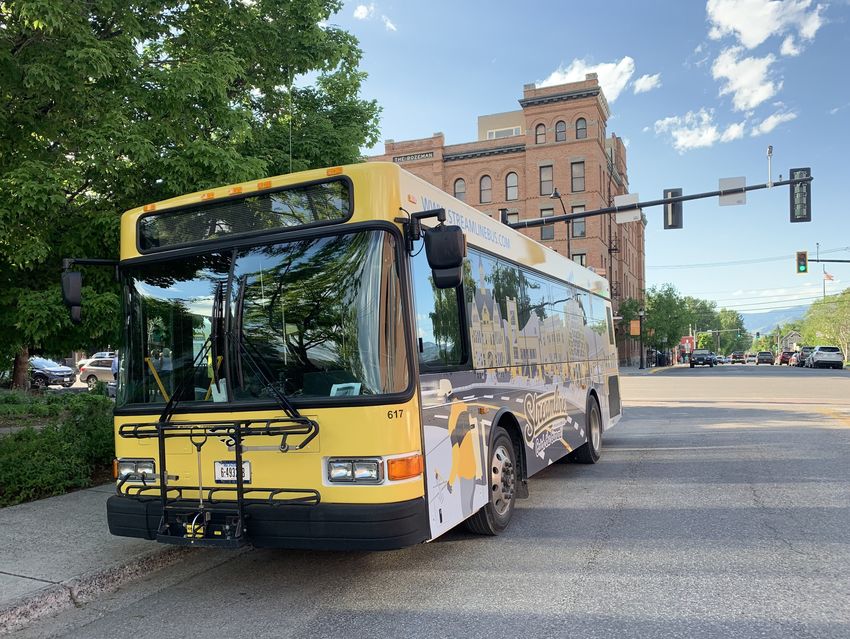
Photo: Diane Bentley Raymond
Redesign Streamline 2020
Transit Development Plan
January 2021
Contents
                         Introduction                                                                                                                                                                   3

                         Public Outreach Summary                                                                                                                                                        4

                         Transit Vision and Service Strategies                                                                                                                                          6

                         Service Recommendations                                                                                                                                                        8

                           PROPOSED NETWORK AND ROUTE ALIGNMENTS  .  .  .  .  .  .  .  .  .  .  .  .  .  .  .  .  .  .  .  .  .  .  .  .  .  . 9

                           CORE SERVICE PLAN .  .  .  .  .  .  .  .  .  .  .  .  .  .  .  .  .  .  .  .  .  .  .  .  .  .  .  .  .  .  .  .  .  .  .  .  .  .  .  .  .  .  .  .  .  .  .  .  .  . 21

                           ADDITIONAL ROUTE SERVICE PLAN .  .  .  .  .  .  .  .  .  .  .  .  .  .  .  .  .  .  .  .  .  .  .  .  .  .  .  .  .  .  .  .  .  .  .  .  .  . 25

                           LONG TERM SERVICE PLAN .  .  .  .  .  .  .  .  .  .  .  .  .  .  .  .  .  .  .  .  .  .  .  .  .  .  .  .  .  .  .  .  .  .  .  .  .  .  .  .  .  .  .  .  . 29

                           TRAVEL TIME COMPARISON .  .  .  .  .  .  .  .  .  .  .  .  .  .  .  .  .  .  .  .  .  .  .  .  .  .  .  .  .  .  .  .  .  .  .  .  .  .  .  .  .  .  .  .  . 35

                         Implementation Plan                                                                                                                                                           36

                         Capital Program                                                                                                                                                               37

                         Financial Plan                                                                                                                                                                40

Redesign Streamline 2020: Transit Development Plan                                                                                                                                                          1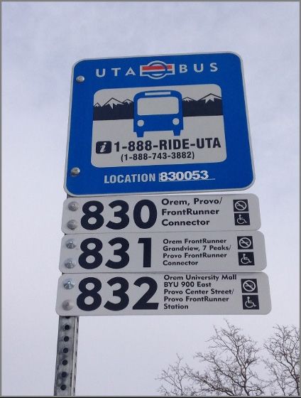
Figures / Tables                                                                                                                            Maps
   FIGURE 1: COMMUNITY SURVEY RESULTS .  .  .  .  .  .  .  .  .  .  .  .  .  .  .  .  .  .  .  .  .  .  .  .  . 4                           MAP 1: PROPOSED ROUTE A . . . . . . . . . . . . . . . . . . . . . . . . . . . . . . . . . . . . 10

   FIGURE 2: COMMUNITY SURVEY RESULTS .  .  .  .  .  .  .  .  .  .  .  .  .  .  .  .  .  .  .  .  .  .  .  .  . 5                           MAP 2: PROPOSED ROUTE B  .  .  .  .  .  .  .  .  .  .  .  .  .  .  .  .  .  .  .  .  .  .  .  .  .  .  .  .  .  .  .  .  .  .  .  . 11

   FIGURE 3: COMMUNITY SURVEY RESULTS .  .  .  .  .  .  .  .  .  .  .  .  .  .  .  .  .  .  .  .  .  .  .  .  . 5                           MAP 3: PROPOSED ROUTE C  .  .  .  .  .  .  .  .  .  .  .  .  .  .  .  .  .  .  .  .  .  .  .  .  .  .  .  .  .  .  .  .  .  .  . 13

   FIGURE 4: BUS STOP SIGN EXAMPLES .  .  .  .  .  .  .  .  .  .  .  .  .  .  .  .  .  .  .  .  .  .  .  .  .  .  .  . 7                    MAP 4: PROPOSED ROUTE D  .  .  .  .  .  .  .  .  .  .  .  .  .  .  .  .  .  .  .  .  .  .  .  .  .  .  .  .  .  .  .  .  .  .  . 14

   TABLE 1: SERVICE SCENARIO COMPARISON .  .  .  .  .  .  .  .  .  .  .  .  .  .  .  .  .  .  .  .  .  .  . 8                               MAP 5: PROPOSED ROUTE E  .  .  .  .  .  .  .  .  .  .  .  .  .  .  .  .  .  .  .  .  .  .  .  .  .  .  .  .  .  .  .  .  .  .  . 15

   TABLE 2: SERVICE SCENARIO COMPARISON .  .  .  .  .  .  .  .  .  .  .  .  .  .  .  .  .  .  .  .  .  .  . 8                               MAP 6: PROPOSED ROUTE F  .  .  .  .  .  .  .  .  .  .  .  .  .  .  .  .  .  .  .  .  .  .  .  .  .  .  .  .  .  .  .  .  .  .  . 17

   TABLE 3: CORE SERVICE SUMMARY  .  .  .  .  .  .  .  .  .  .  .  .  .  .  .  .  .  .  .  .  .  .  .  .  .  .  .  .  . 21                  MAP 7: PROPOSED ROUTE G .  .  .  .  .  .  .  .  .  .  .  .  .  .  .  .  .  .  .  .  .  .  .  .  .  .  .  .  .  .  .  .  .  .  . 18

   TABLE 4: CORE SERVICE SUMMARY  .  .  .  .  .  .  .  .  .  .  .  .  .  .  .  .  .  .  .  .  .  .  .  .  .  .  .  .  . 21                  MAP 8: MICROTRANSIT ZONES .  .  .  .  .  .  .  .  .  .  .  .  .  .  .  .  .  .  .  .  .  .  .  .  .  .  .  .  .  .  .  .  .  . 20

   TABLE 5: ADDITIONAL ROUTE SERVICE SUMMARY  .  .  .  .  .  .  .  .  .  .  .  .  .  .  .  .  . 25                                          MAP 9: WEEKDAY CORE SERVICE NETWORK .  .  .  .  .  .  .  .  .  .  .  .  .  .  .  .  .  .  .  .  .  . 22

   TABLE 6: ADDITIONAL ROUTE SERVICE SUMMARY  .  .  .  .  .  .  .  .  .  .  .  .  .  .  .  .  . 25                                          MAP 10: WEEKEND CORE SERVICE NETWORK  .  .  .  .  .  .  .  .  .  .  .  .  .  .  .  .  .  .  .  . 23

   TABLE 7: LONG TERM SERVICE SUMMARY .  .  .  .  .  .  .  .  .  .  .  .  .  .  .  .  .  .  .  .  .  .  .  . 29                             MAP 11: HALF MILE ACCESS CORE SERVICE PLAN .  .  .  .  .  .  .  .  .  .  .  .  .  .  .  .  . 24

   TABLE 8: LONG TERM SERVICE SUMMARY .  .  .  .  .  .  .  .  .  .  .  .  .  .  .  .  .  .  .  .  .  .  .  . 30                             MAP 12: ADDITIONAL ROUTE SERVICE NETWORK .  .  .  .  .  .  .  .  .  .  .  .  .  .  .  .  .  . 26

   TABLE 9: COMPARISON OF TRAVEL TIME  .  .  .  .  .  .  .  .  .  .  .  .  .  .  .  .  .  .  .  .  .  .  .  .  . 35                         MAP 13: ADDITIONAL ROUTE SERVICE WEEKEND NETWORK  .  .  .  .  .  .  .  . 27

   TABLE 10: CAPITAL IMPROVEMENT COSTS – BUS STOPS .  .  .  .  .  .  .  .  .  .  .  . 37                                                    MAP 14: HALF MILE ACCESS ADDITIONAL ROUTE PLAN .  .  .  .  .  .  .  .  .  .  .  .  . 28

   TABLE 11: ANNUAL OPERATING COSTS .  .  .  .  .  .  .  .  .  .  .  .  .  .  .  .  .  .  .  .  .  .  .  .  .  .  . 40                      MAP 15: LONG TERM SERVICE NETWORK  .  .  .  .  .  .  .  .  .  .  .  .  .  .  .  .  .  .  .  .  .  .  .  . 31

   TABLE 12: CAPITAL BUDGET .  .  .  .  .  .  .  .  .  .  .  .  .  .  .  .  .  .  .  .  .  .  .  .  .  .  .  .  .  .  .  .  .  .  .  . 40   MAP 16: HALF MILE ACCESS LONG TERM SERVICE PLAN .  .  .  .  .  .  .  .  .  .  .  . 32

                                                                                                                                            MAP 17: PROPOSED ROUTE C LONG TERM  .  .  .  .  .  .  .  .  .  .  .  .  .  .  .  .  .  .  .  .  .  .  . 33

                                                                                                                                            MAP 18: PROPOSED ROUTE E LONG TERM  .  .  .  .  .  .  .  .  .  .  .  .  .  .  .  .  .  .  .  .  .  .  . 34

Redesign Streamline 2020: Transit Development Plan                                                                                                                                                                                                                                   2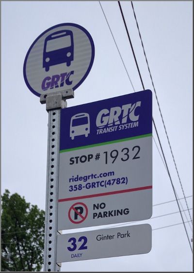
Introduction
Bozeman, Montana is one of the fastest growing
micropolitan areas in the country. After the 2020 U.S.
Census is fully processed, the population of Bozeman
is expected to surpass 50,000. This number is an
important threshold in Federal Transit Administration
(FTA) formula funding, changing Bozeman’s
classification from rural to a small urbanized area,
impacting grant eligibility. Furthermore, HRDC would
no longer be an eligible sub recipient of federal funds,
requiring either the establishment of an urban transit
district (UTD) or for the City of Bozeman or Gallatin
County to become responsible for providing service.
A UTD or municipality could contract with HRDC to
operate service, but they would become the policy
body and recipient of funds.
The Streamline routes and network design have not
had a major evaluation and update since the system
started in 2006. With such rapid population growth and
potential changes to funding, Streamline launched
Redesign Streamline 2020 to evaluate existing service
and rethink Streamline service for the future.
The first step of Redesign Streamline 2020 was a
study of existing service and market conditions, the
findings of which are detailed in the Existing Service
and Market Conditions report in April 2020. The next
step was the development of service strategies and
recommendations, which were vetted by the public
outreach process and Streamline Board. The project
culminates with this Transit Development Plan which
solidifies the final service recommendations and
provides implementation guidance.

Redesign Streamline 2020: Transit Development Plan         3
Public Outreach
                                                                  FIGURE 1: COMMUNITY SURVEY RESULTS
                                                                  How likely would each of the changes result in you riding Streamline or using it more often?

Summary
An online community survey was conducted in May
of 2020. A total of 889 responses were received, of
which 136 were students and 753 were non students.
The full results of the survey are summarized in
Appendix A.
Respondents were given a choice of actions and
asked how likely these improvements would result in
their increased use of Streamline. The top responses
for regular riders were improved on time performance,
a better tracking app, later service, more direct routes,
and service closer to destinations. The top choices for
non-riders were service closer to home, more direct
routes, service closer to destinations and improved on
time performance.
With limited resources it impossible to both provide
both more direct routes and provide more coverage
that will result in service closer to many homes. The
recommendations described below are designed to
address existing issues with on time performance,
to provide more direct service to stops that have the
highest usage and to provide two way service to all         Better service coverage, improved customer information      be an option, however this will require an increased
major destinations (as opposed to the one way service       and amenities were the top three responses. Although        operating budget. The implementation plan, which
that exists at many locations today) and the two way        increasing service coverage was the top response,           will be developed upon the conclusion of feedback on
service may address the desire for providing service        the actual locations in which individuals requested         the service recommendations described below, will
closer to destinations for many respondents.                service were scattered throughout the service area          address customer information.
                                                            and included many low density neighborhoods that
In addition to the multiple choice question respondents     simply cannot support fixed route transit. In some
were asked to write in the top actions that would result    areas microtransit (as described on page 19) could
in using Streamline more often. The responses are
summarized in Figure 2 below.

Redesign Streamline 2020: Transit Development Plan                                                                                                                             4
FIGURE 2: COMMUNITY SURVEY RESULTS
Improvement Ideas
FIGURE 3: COMMUNITY SURVEY RESULTS
Improvement Ideas
Redesign Streamline 2020: Transit Development Plan 5Transit Vision
networks impact several aspects of transit: how easy Similarly, for anyone who works on weekends, while
it is for pedestrians to access the network; transit they could take transit to work on weekdays, lack of
travel time; and connectivity between destinations. weekend service discourages transit use throughout
and Service This means Streamline should focus service in areas
where the density and design of the surrounding
the rest of the week. Increasing the hours and days
that service is available will improve customer mobility,
Strategies land uses can support efficient and effective transit.
Conversely HRDC should work closely with the City
of Bozeman, City of Belgrade, and Gallatin County to
especially for individuals who work hours outside of
the traditional Monday-Friday 9am-5pm period.
Improve Frequency: Out-of-vehicle wait time is
assure that future higher density development occurs
VISION along transit corridors identified in this plan and that
the most important factor individuals consider when
deciding whether to use transit. Improving service
The following vision identifies the goals for the design fosters safe and attractive pedestrian frequency (how often the bus comes) can greatly
HRDC’s service and serves as the foundation for access to transit. enhance the overall passenger experience and attract
recommendations:
Matching transit service to market demand requires a more riders to the system.
The vision for Streamline to be the provider of mobility focus on the actual travel needs of potential customers. Improve Information Availability: One potential
services and alternatives to the single occupancy This includes span of service and frequency which are barrier to transit use is whether it is easy for customers
vehicle in southwest Montana. discussed in the next section. to understand how routes operate and where they go.
Many customers and stakeholders indicated a need for
SERVICE STRATEGIES Improve the Customer Experience
more accessible system information, including better
The recommendations in this Transit Development Reduce Travel Time on the Bus: The amount of information at bus stops and easy to understand route
Plan (TDP) include three different scenarios, which time passengers spend traveling on a bus to their maps and schedules. The proposed service changes
vary in service levels depending on funding availability. destination influences their experience and impacts provide an opportunity to adopt a new style of bus
However, the core service strategies that address the how often and for what trips they choose to use stop signs and route information that is more user-
need to create a useful, understandable, and operable transit. One-way routes increase the amount of time friendly and accessible. It is recommended that HRDC
integrated network that can be used for all kinds of passengers must spend on the bus and makes the develop clearly marked bus stop signs that include the
trips are described below and remain the same for service less attractive. Additionally, riders perceive following information:
each scenario. travel delay as twice as long as it actually is, so » Streamline Logo
out-of-direction movements can significantly deter
Match Transit Service to Market Demand » Stop ID Number
ridership. Transit already struggles to be an attractive
choice in an area like Bozeman where travel times are »Customer service information, such as website
For Streamline to remain financially sustainable, the address, help-line phone number, and QR code
short and there are low levels of traffic congestion.
agency needs to focus on providing bus service where
Reducing travel times can help make transit service » Routes that service the stop
it can be most successful. Transit success is directly
more competitive with automobile travel. Providing bi-
influenced by surrounding development patterns and
directional service on routes will reduce travel time,
density. For transit to be tremendously successful,
improve customer satisfaction, and make the service
there must be a strong mix of population and
more attractive to both existing and potential riders.
employment densities, as well as a street and sidewalk
network that promotes walkability and access. Higher Increase Service Spans: Service span affects
population and employment densities are supportive passengers’ ability to use transit for all their daily
of transit because they provide a larger potential needs. If riders can take a bus to work but cannot take
customer base to draw from. The road and sidewalk the same bus home because the service span is too
short, they will likely forego riding the bus altogether.
Redesign Streamline 2020: Transit Development Plan 6FIGURE 4: BUS STOP SIGN EXAMPLES In addition to improved bus stop signs, it is also recommended that HRDC improve the real-time tracking mobile app. Criticism of the accuracy of the current app was one of the top concerns in the on board survey. An accurate app allows customers to see next-bus arrival time, access trip planning functions, and see route maps and schedules from their mobile device. This effort could be implemented with the other proposed improvements as part of a coordinated update of Streamline’s services. Improve Access to Transit: The transit customer’s trip does not begin and end at the bus stop. Most customers will walk to and from the bus and an increasing number of customers may access by bicycle or other micro mobility devices. While HRDC or a successor UTD will not have responsibility for the walkways or paths used by customers to access transit, it is incumbent to locate stops in locations that optimize direct access for the surrounding areas. This is particularly critical in areas that do not have a classic grid street pattern where the actual path transit customers must take to access bus service from the surrounding neighborhoods should be considered when locating bus stops. It is also essential to partner with the entities responsible for walkways and roadways to provide a safe and attractive environment for pedestrian and bicyclists within the walkshed of transit stops. Regarding the stops themselves it is critical to provide hardscape for customers where customers are waiting and getting on and off buses along with ADA access and benches or shelters to provide comfort and protection form the elements while waiting for the bus. (See Capital Program below for more details on bus stop improvements.) Redesign Streamline 2020: Transit Development Plan 7
Service
Recommendations
The following service recommendations were
developed in close collaboration with HRDC staff
                                                                              TABLE 1: SERVICE SCENARIO COMPARISON
and reflect the vision and service strategies
                                                                              Service Availability1
described above. The service recommendations are
presented as a series of three funding scenarios:
Core Service, Additional Route, and Long Term. The                                SERVICE PLAN                                                      ADDITIONAL
                                                                                                          EXISTING            CORE SERVICE                              LONG TERM
                                                                                    ELEMENT                                                           ROUTE
Core Service Scenario has four routes operating
throughout the year Monday through Friday and                                                              6 weekday             5 weekday            6 weekday           8 weekday2
portions of three routes operating on weekends. A fifth                       Number of Routes             4 Saturday            3 Saturday           4 Saturday          7 Saturday
route, the current Livingston route would operate for                                                       1 Sunday              3 Sunday             4 Sunday            7 Sunday
six months between October and April. Skyline service                                                  30/60 min weekday3     30/60 min weekday    30/60 min weekday   30/60 min weekday
between Big Sky and Bozeman would serve Four                                  Frequency                 60 min Saturday        60 min Saturday      60 min Saturday     30 min Saturday
Corners. The Additional Route scenario adds a sixth                                                      60 min Sunday          60 min Sunday        60 min Sunday       60 min Sunday
route. In the Long Term scenario, service levels are                                                     6:30am-7:15pm
                                                                                                                               6:30am-9:30pm        6:30am-9:30pm
significantly increased, with two additional fixed routes                                                     wkd1                                                     6am-10pm weekday
                                                                                                                                    wkd4                 wkd3
                                                                              Availability               7:30am-6:15pm                                                 8am-8pm Saturday
and three micro-transit zones added. A summary of                                                                              8am-7pm wknd         8am-7pm wknd
                                                                                                            Saturday                                                    8am-8pm Sunday
the key elements for each service scenario is shown                                                     9am-5pm Sunday
                                                                                                                                     -                    -
in Table 1.1 2 3 4 5 6 7
                                                                                                        100% of existing       89% of existing      93% of existing     93% of existing
                                                                              Access within 1/2 mile     weekday stops          weekday stops        weekday stops       weekday stops
                                                                              of service                100% of average        97% of average       99% of average      99% of average
                                                                                                       weekday boardings      weekday boardings    weekday boardings   weekday boardings

                                                                              TABLE 2: SERVICE SCENARIO COMPARISON
1 This table excludes the LateNight Downtown route and Bridger Bowl           Service Statistics1
service which will continue to operate unchanged assuming funding
remains in place.
2 In addition to eight fixed routes, there are three microtransit zones.                                                                               ADDITIONAL
3 30-minute service is provided on four routes during peak hours during        SERVICE PLAN ELEMENT              EXISTING         CORE SERVICE                           LONG TERM
the school year only. The Green Route has four trips in each direction; the
                                                                                                                                                         ROUTE
Livingston Route has one AM trip and one PM trip.
4 Route A and C only. All other routes operate until 7:30pm.                  Revenue Hours                        21,594               22,075             27,620            74,827
5 13 full-size buses for fixed route service and three smaller vehicles for
                                                                              Revenue Miles                       384,207              300,138            357,307           999,423
microtransit service
6 Excludes Bridger Bowl. Includes cost of operating Livingston Route          Peak Vehicles                             8                 8                  10               165
six months of the year and continued operation of LateNight Downtown.
Reflected in 2020 dollars.                                                    Operating Cost6                    $1,514,589          $1,548,3247         $1,937,251        $5,248,393
7 Assumes longer service span on Route A and C, 30-minute peak service
operates all year and Sunday service span is same as Saturday.

Redesign Streamline 2020: Transit Development Plan                                                                                                                                         8
PROPOSED NETWORK AND the north, connecting residents with employment, Route B
ROUTE ALIGNMENTS educational, and shopping opportunities (Map 1).
The route begins at the MSU Strand Union Building, This route will connect the Gallatin Valley Mall,
The key difference between the existing and proposed traveling through the center of campus along S. 11th Downtown, and Deaconess Hospital via a direct two
networks is that routes, with one small exception, no Avenue, then east on W. College Street and north on way route operating primarily on Main Street (Map
longer operate as one-way loops. Instead, all routes S. Willson Ave to Downtown. It will then loop to serve 2). Bozeman High and the Main Library will also
provide bi-directional service along Streamlined the Downtown Transit Center via Babcock Street, N. benefit from two way service. The route will begin
alignments. This was done to shorten customer travel Rouse Avenue, and E. Mendenhall Street.8 The route at Gallatin Valley Mall and travel along Main Street
times and make the system easier to understand and continues westbound on Mendenhall Street and then to Downtown Bozeman. Traveling eastbound it will
navigate. To reduce confusion with current bus service, northbound on N. 7th Avenue to Oak Street where make a counterclockwise loop via S. Willson Avenue,
all recommended routes are lettered. The new network the route will deviate to serve Walmart. After serving Babcock Street, N. Bozeman Avenue, E. Mendenhall
deviates far enough away from the existing service Walmart the route will travel west on W. Oak Street, Street and N. Tracey Avenue to serve the Downtown
that it will be easier to communicate route changes to north on N. 15th Avenue, west on Tschache Street Transit Center and facilitate transfers with Route A.9 It
riders based on an entirely new lettering system rather and north on N. 19th Avenue. At the north end of the will continue traveling along Main Street to Haggerty
than trying to figure out which route most closely route it will make a one way loop via Cattail Street, N. Lane, Ellis Street and Highland Blvd. to Deaconess
resembles the one they are used to riding. However at 27th Avenue, Catron Street and Max Avenue to the Hospital. Customers wishing to board on Haggerty
the time of implementation identifying routes by color terminal in the parking lot near Staples. Southbound Lane and Ellis Street will need to board as the bus
as is the current practice may continue. the route will travel on Max Avenue, Cattail Street to N heads to Deaconess Hospital since making a left turn
The proposed Core Service network includes four 19th Avenue and replicate the northbound route back from Haggerty Lane to Main Street in the reverse
year-round routes (Map 9), while the Additional to MSU. This route will connect with all other proposed direction is not safe. The bus will use Highland Blvd.
Route network (Map 12) adds a fifth route to provide Streamline routes – Route B Downtown, Route C at between the Hospital and Main Street. The route will
additional geographic coverage and the Long Term MSU and Route D at Walmart. It will also connect with operate westbound on Main Street to Gallatin Valley
Plan (Map 15) adds a sixth and seventh route for Skyline Bus at Walmart and MSU and with Jefferson Mall jogging via N. Rouse Street, Mendenhall, and
further coverage to growth areas. In all scenarios Line intercity buses at Walmart. In the Additional Bus N 7th Avenue to serve the Downtown Transit Center.
the proposed service remains focused on key plan it will connect with Route E Downtown and in the From Gallatin Valley Mall this route will also make a
destinations, providing bi-directional service, and in Long Term Plan it will connect with Route F at MSU one way loop via Huffine Lane, S. Cottonwood Road,
residential areas with transit-supportive density and and at the northern terminal and Route G at Walmart. Fallon Street, Ravalli Street, S. Fowler Avenue and
high existing ridership. Individual route descriptions Route A and C will be interlined at MSU Strand Union. Huffine Lane back to the Mall. In the AM, the bus will
and maps are provided below. Passengers wishing to travel between the two routes make this loop after laying over at the Mall before the
may stay on the bus during its layover. Interlining is eastbound trip. In the PM buses will continue on this
Route A necessary because the round trip running time on loop after stopping at the Mall and taking a layover
Route A exceeds 60 minutes while the round trip after completing this loop before continuing eastbound.
This route will provide all-day local service along a running time on Route C is about 40 minutes. By Passengers riding through the Mall may stay on the
north/south alignment connecting MSU in the south interlining the shorter route with the longer route; one bus during its layover. This route will connect with
with Target and adjacent retail establishments in less bus is needed to provide the combined service. Route A Downtown and Route C at the Mall.
8 The loop is shown counterclockwise based on the existing westbound one-way direction of Mendenhall. If the City converts Mendenhall to a two-way street requiring the removal of the center transit island the loop will be made in the
clockwise direction and buses will stop on the curb next to the transit waiting room.
9 If the City converts Mendenhall to a two way street requiring the removal of the center transit island the loop will be made in the clockwise direction and buses will stop on the curb next to the transit waiting room.
Redesign Streamline 2020: Transit Development Plan 9Catron St
¡
|
|
N 27th Ave
Manley Rd
Target
N 19th Ave
|
| MAP 1: PROPOSED ROUTE A
p
5
¡
|
¡
|
¡
|
|
Boylan Rd
Baxter Ln
Tschache Ln
Walmart
N 15th Ave
p
5
"
Oak St
Gallatin High School #
!
6
(5
90
Bozeman Senior Center
Durston Rd (
!
®
N 7th Ave
Bozeman
N Rouse Ave
Bozeman High School
6
(5 ¡ W Mendenhall St ¡
|
|
|
|
|
|
Main St
¡
|
¡
|
¡ W Babcock St Bozeman Public Library
|
|
S Church Ave
p
c
¡
|
|
S Willson Ave
Gallatin Valley Mall
p
5
Ha
g ge
W College St W College St rty
Deaconess Hospital Ln
Cottonwood Rd
p
G
Montana State University
6
(5
S 11th Ave
MSU SUB
!
b W Grant St
Proposed Weekday Route A City Boundaries
USA Urban Areas
° 0 0.25 0.5 1 Miles
Redesign Streamline 2020: Transit Development Plan 10Walmart
MAP 2: PROPOSED ROUTE B
p
5
Oak St
Gallatin High School EO
6
(5
ak
St
"
#
! 90
Bozeman Senior Center
W Durston Rd
Durston Rd (
!
®
N Rouse Ave
N Tracy Ave
N 7th Ave
Bozeman High School
6
(5 W Mendenhall St ¡
|
|
|
W Main St |
|
¡
|
|
¡
| E Main St
|
¡
|
¡
¡ | ¡
|
|
|
|
|
Bozeman Public Library
¡
St
p
n c
¡
ai
|
|
Ravalli St
Highland Blvd
S Bozeman Ave
M
S Willson Ave
¡
|
|
Fallon St W
W Koch St
Cottonwood Rd
||
Gallatin Valley Mall
¡
|
|
Ha
| p5 g
¡
¡
| ge
Bozeman ||
rty
Ln
¡
US Hwy 191
¡
Deaconess Hospital
|
|
|
¡
|
p
G
Montana State University
6
(5
Cottonwood Rd
S 11th Ave
Highland Blvd
Fowler Ln
Proposed Weekday Route B City Boundaries
USA Urban Areas
° 0 0.2 0.4 0.8 Miles
Redesign Streamline 2020: Transit Development Plan 11Route C Route D Route E
This route connects MSU with Gallatin Valley Mall and The proposed Route D will provide service to Belgrade The proposed Route E will operate in the Additional
West Bozeman residential areas (Map 3). Beginning at (Map 4). Instead of operating through Four Corners Route (Map 12) and Long Term scenarios (Map 15).
the MSU Strand Union Building the route will operate the route will use the I-90 frontage road to access It will operate bi directionally between Downtown
via Grant Street, S. 11th Avenue, and W. College Street Belgrade. This will enable Streamline to directly serve Bozeman and the new Gallatin High School serving
to the Mall. From the Mall the route will make a one neighborhoods in Belgrade without needing to cross the Public Safety Complex, Bozeman Senior Social
way loop via Huffine Lane, S. Fowler Avenue, Fallon the railroad tracks at grade and be subject to delays Center, and the Northside of Bozeman High. From
Street, Ferguson Avenue, Durston Road, Hunters when long freight trains pass. Starting at Walmart this the Downtown Transit Center it will operate via N.
Way, W. Babcock Street, and W. Main Street back to route will travel via W. Oak Street and N. 7th Avenue, Tracey Avenue, E. Babcock Street, N. Rouse Avenue,
the Mall. From the Mall the route will return to MSU via continuing on the I-90 Frontage Road and W. Main Tamarack Street, N. 7th Avenue, Durston Road, N.
W. College Street, S. 11th Avenue, and Grant Street. Street in Belgrade to a one way terminal loop via 27th Avenue, and W. Oak Street to Cottonwood Road.
This route will be interlined with Route A at MSU and N. Grogan Street, into Spooner Road, Triple Crown After turning at the round-about at W. Oak Street and
connect with Route B at Gallatin Valley Mall. Unlike Road, Jack Rabbit Lane, and W. Main Street. The Cottonwood Road the bus will return Downtown via
the current Yellow Line, this new route will serve the route will then return to Walmart in Bozeman by the the reverse of the above route except that it will use
Gallatin Valley Mall in both directions providing better reverse of the above Route. Route D will connect E. Mendenhall instead of E. Babcock Street. Route
access to MSU for individuals using the park and ride with Route A, Skyline Bus and Jefferson Line intercity E will connect with Route A and B in Downtown and
at the Mall as well as students employed or wishing buses at Walmart. The parking lot at Grace Lutheran intersect with Route A at Oak and 7th Avenue.
to shop at the Mall. Route A and C will be interlined at Church can serve as a park and ride for customers not In the Long Term Plan Route E will be extended to
the MSU Strand Union Building. Passengers wishing within walking distance of Route D. MSU southbound via Mendenhall Street, S. 11th AVE
to travel between the two routes may stay on the bus Even though Route D operates close to Bozeman and Grant Street to MSU Strand Union. Northbound
during its layover. Interlining is necessary because the Airport, it is not recommended that it serve it in the route will operate form MSU via Grant, S. 11th
round trip running time on Route A exceeds 60 minutes the short term. This limited schedule for Route D Avenue, Main Street, S. Willson Avenue, Babcock
while the round trip running time on Route C is about is not convenient for either airport employees or Street, Bozeman Avenue and Mendenhall Street to
40 minutes. By interlining the shorter route with the passengers and the extra time to serve the airport will the Transit Center where it will continue via the above
longer route; one less bus is needed to provide the inconvenience most Route D passengers. In the Long route to Gallatin High School. In the Long Term Plan
combined service. Term Plan if Route D service is increased to operate Route E will also connect with Route A, C, and F at
In the long term plan, concurrent with the during the same service span as the other local routes MSU and intersect with Route E at 27th and Durston
implementation of Route F (map 11) the one way the possibility of serving the airport in one direction and 27th and Oak.
loop segment will become bi-directional. Route G will should be explored. (There is insufficient time to
replace the Hunters Way, Babcock, and Main Street serve the airport in both directions and maintain a 60
segment while Route C will be extended via Durston minute headway with one bus and make connections
to a terminal loop of 22nd Avenue, 19th Avenue back with Route A at Walmart.) If this is pursued serving
to Durston. the airport en route to Belgrade in the morning and
en route to Bozeman in the afternoon would best
accommodate customer demand and minimize
inconvenience.
Redesign Streamline 2020: Transit Development Plan 12W Durston Rd MAP 3: PROPOSED ROUTE C
¡
|
|
Durston Rd
¡
|
|
N 7th Ave
|
|
¡
|
¡
|
W Beall St
|
|
Hunters Way
S Ferguson Ave
¡
Bozeman High School
6
(5
W Main St
W Babcock St
St
a in
M
|
¡
|
W Koch St
W
Gallatin Valley Mall
Fallon St p
5
¡
|
|
¡
|
|
US Hwy 191
W College St
Montana State University
6
(5
S 11th Ave
Fowler Ln
W Grant St
S 19th Ave
Proposed Weekday Route C City Boundaries
USA Urban Areas
° 0 0.1 0.2 0.4 Miles
Redesign Streamline 2020: Transit Development Plan 13Park and Ride
!
b
6p
Tubb Rd
¡
|
|
Triple Crown Rd
|
|
¡
|
|
¡
Jack Rabbit Ln N Grogan St MAP 4: PROPOSED ROUTE D
Bozeman Yellowstone
Springhill Rd
||
EM
¡
a in International Airport
Bostwick Rd
St
Thorpe Rd
Belgrade
S Alaska Rd
"
!
#
Nelson Rd
90
Fro
nt
ag
eR
d
M
c Il
ha
tta
Rdn
Hulbert Rd W
Target
Love Ln
p
5
N 7th Ave
Baxter Ln
Bozeman Walmart
p
Oak St
5
Gallatin High School
6
(5
(
!
®
Proposed Weekday Route D City Boundaries
USA Urban Areas
° 0 0.425 0.85 1.7 Miles
Redesign Streamline 2020: Transit Development Plan 14MAP 5: PROPOSED ROUTE E
Baxter Ln
Hunters Way
"
#
! 90
Walmart
p
5
Oak St
Oak St
E Oak St
Gallatin High School
6
(5
Cottonwood Rd
N 27th Ave
W Tamarack St
Bozeman Senior Center
N 7th Ave
W Durston Rd
Durston Rd Durston Rd
(
!
®
N Rouse Ave
Bozeman
W Beall St
Bozeman High School
6
(5
¡
|
|
E Mendenhall St
N Tracy Ave
|
W Main St |
¡
|
|
¡
W Babcock St
W Babcock St
p
¡
|
|
c
Gallatin Valley Mall
p
Fallon St 5
W College St
6
(5
Proposed Weekday Route E City Boundaries
USA Urban Areas
° 0 0.15 0.3 0.6 Miles
Redesign Streamline 2020: Transit Development Plan 15Route F Route G Livingston
Route F would operate only in the Long Term plan (Map Route G would operate only in the Long Term Plan The Livingston route currently averages 8 boardings
6). It will operate bi directionally between MSU and (Map 7). It will operate bi directionally between per day; however can carry up to 35 boardings per
the Billings Clinic serving potential infill development Walmart and Story Mill Park on weekdays and it will day during bad winter weather. Because of its very low
along N. 27th Ave north of Oak Street. In conjunction be extended to the Drinking Horse Mountain and productivity during good weather it is recommended
with this route, Route C will be modified to provide College M Trailheads. Beginning at Walmart this that this route only operate for half the year from mid-
two way service along a portion of the proposed one route will operate via Oak Street, N. 7th Avenue. W. October to mid-April.
way loop in the Core Service and Additional Route Griffin Drive, and Bridger drive to Story Mill Park were
scenarios, while Route F will provide two way service on weekdays it will turn around in the parking lot. On Skyline Service to Four Corners
on the other portion of this loop. Both routes would weekends route G will be extended via Bridger Drive to
With the recommendation that the proposed bus route
operate between MSU and the Gallatin Valley Mall via both trailheads where it will run around in the College
serving Belgrade (Route D) via the I-90 corridor instead
the alignment proposed for Route C on a staggered M parking lot. This route will serve the new Food Bank/
of through Four Corners, it is recommended that
headway to provide increased frequency along this Resource Hub/Year Round Warming Center planned
HRDC develop an agreement with the Gallatin County
segment. Route F would then operate via Main Street, to be located on Griffin Drive. Route G will be timed to
Big Sky Transportation District, the operator of Skyline
W. Babcock Street, Hunters Lane. Durston Street, connect with Route A and D at Walmart.
Bus to allow passengers to ride locally between Four
N. 27th Avenue, to a terminal loop via Valley Center
LateNight Downtown Corners and Bozeman free of charge. Buses would
Road, Catron Street, Max Avenue, and Cattail Street,
use the existing Skyline Stop at Cardinal Distributing
back to N. 27th Avenue. This route will connect with
The existing LateNight Downtown Loop will continue (near the existing Jack Rabbit/Shedhorn stops on the
Route A and E at MSU, Route A at Target and Route B
to operate Thursday through Saturday during the current Green Line) and stop at the current Green line
at Gallatin Valley Mall. It will also intersect with Route
school year via the current route. Although technically stops on Huffine Lane near Arrowhead and Gooch
E at 27th and Durston and 27th and Oak.
a one way loop it essentially connects Downtown Hill. It is also recommended that Skyline relocate their
with student residential areas around campus on a MSU stop to the Strand Union Building to connect with
30 minute headway and therefore does not subject Streamline buses. This service can be supplemented
passengers to 60 minute round trips that the existing by utilizing Galavan buses to pick up or drop off
daytime route design does. customers at any one of these three stop locations
and connect with Streamline at the Gallatin Valley Mall
or MSU at times that Skyline is not operating. In the
Long Term Plan establishing a microtransit zone (see
below) is recommended. If Four Corners is not part
of a future UTD, a fare should be charge for travel on
Four Corners microtransit service.
Redesign Streamline 2020: Transit Development Plan 16Davis Ln
||
MAP 6: PROPOSED ROUTE F
¡
Valley
Center
|
¡
|
Rd
Catron St
N 27th Ave
Target
p
5
Manley Rd
Max Ave
|
|
¡
Baxter Ln
Hillside Ln
N 27th Ave
Walmart
Bozeman
"
#
!
p
5 90
Gallatin High School
6
(5
Bozeman Senior Center
Durston Rd
(
!
®
Bozeman High School
W Babcock St
Main St 6
(5
Bozeman Public Library
p
c
Gallatin Valley Mall
Fron
tage
p
5 Rd
W College St Deaconess Hospital
p
G
Montana State University
Cottonwood Rd
6
(5
S 11th Ave
MSU SUB
!
b W Grant St
Proposed Weekday Route F City Boundaries
USA Urban Areas
° 0 0.25 0.5 1 Miles
Redesign Streamline 2020: Transit Development Plan 17MAP 7: PROPOSED ROUTE G
Manley Rd
Gallatin
National Forest
College M Trailhead
and Picnic Area
McIlhattan Rd U
Bridger Canyon Dr
ry Rd
che
Hat
Bridger Canyon Dr Fish
W Griffin Dr
Story Mill
Community Park
U
Bozeman
N 7th Ave
Walmart
p
5
Oak St W Oak St
"
#
!90
E Oak St
Bozeman Senior Center
(
!
®
6
(5
Proposed Weekday Route G Route G City Boundaries
(weekend service) USA Urban Areas
° 0 0.2 0.4 0.8 Miles
Redesign Streamline 2020: Transit Development Plan 18Microtransit
A common request in both the stakeholder interviews For example under the Core Service Plan, a zone The one-time cost of acquiring hardware and software
and online survey conducted as part of this project bounded by Main Street, Wallace Avenue, Tamarack is $20,000 to $50,000. The annual cost of licensing
was the desire to expand the coverage of Streamline Street and N. 7th Avenue, would allow for connections and maintenance is $30,000 to $60,000. Operating
to serve both existing and potential development. As to Route A and B at Black and Mendenhall. A second and capital cost are reflected in Table 11 (Operating)
discussed under service strategies above, the density zone bounded by Durston Road, N. 27th Avenue, and Table 12 (Capital).
and/or design of much development is not supportive Baxter Lane and N. 19th Avenue that would transport
of fixed route transit. Microtransit can be an alternative passengers to Gallatin Valley Mall for connections with Vanpool from Three Forks and Manhattan
to expand the reach of Streamline. Route B and C. The zones would replace the fixed
HRDC should determine if there is interest in
Microtransit is a form of demand-responsive transport. route service on the existing Blue line and Red line
establishing vanpools for residents of Three Forks and
This transit service offers flexible routing and/or flexible in the Core Service plan. In the Additional Route plan
Manhattan. Vanpools would be most effective if there
scheduling of minibus vehicles. Possible pick-up/drop- there would be no need for the establishment of these
is a common destination such as MSU, Deaconess
off stops are restricted (usually within a geofenced zones as they will be replaced by a new fixed route.
Hospital or Downtown Bozeman.
area), and transit can be provided either as a stop-to- In the longer term microtransit could be designed to
stop service or curb-to-curb service. serve River Rock and Belgrade providing for internal Bridger Bowl Service
Dynamic scheduling and routing of microtransit trips within the area and connections with Route D.
Other areas particularly south of MSU, Four Corners No change planned. Continued operation of service
service limit the productivity of microtransit. In a survey
and other areas in West Bozeman could be also be is contingent on retaining funding specifically for this
TMD conducted on microtransit services, productivity
possible microtransit zones. service.
ranged from 2.42 to 7.5 boardings per hour. Therefore
microtransit should be targeted to areas that may not There are several options for implementing microtransit
support conventional fixed route services but still can including national specialty firms or a local provider
generate ridership at the higher end of the productivity like Galavan. If Galavan is used to provide microtransit
scale. Extending the reach of fixed route service, i.e. software and hardware will likely need to be acquired
first and last mile connectivity, is a common application to provide general public microtransit. This can benefit
to microtransit. existing Galavan customers by eliminating the need
To avoid over subscription of microtransit in Bozeman to for making advance reservations. Customers with a
(over subscription will lead to longer wait times or smart phone could book rides using an app installed
the need to add vehicles and the associated cost to on their phone. Those without a smart phone or who
keep response times low) a fare should be charged. feel more comfortable making reservations over
However if microtransit is used to replace fixed route the phone could call the dispatch center, where the
service, concerns about fairness can arise; particularly customer service agents would use the app to book
if it is replacing free fixed route service. If service the trip. Because fewer calls will be received it may be
is provided for free it needs to be limited to clearly possible to reduce cost of the reservation center.
defined zones with a focus of connecting to fixed route
service for access to the rest of the community.
Redesign Streamline 2020: Transit Development Plan 19Spain Bridge Rd
City of Bozeman, MT
SM
an
ha
Belgrade Catron St Target
p
tta
n
5
Park and Ride
!
b
6p
Bozeman Yellowstone
"
!
#90
Walmart
River International Airport
N 27th Ave
Thorpe Rd
p
5
N 19th Ave
W Oak St
Rock
Fro
6
(5 Gallatin High School E Tamarack St
N 7th Ave
nt
ag
eR (
!
® Bozeman Senior Center
N Ferguson
d
Bozeman High School
6
(5 E Main St Bozeman Public Library
S Willson Ave
p
Gallatin Valley Mall c
Sp r
i ng
p
5 Deaconess Hospital
Highland Blvd
W College St
h ill
US
Jackrabbit Ln
p
G
Rd
Montana State University
Hw
y1
0 6
(5 !
b MSU SUB
E Ka
gy B
lvd
Gallatin
National Forest
"
!
#90
Hulbert Rd W
Bozeman
Target College M Trailhead
State Hwy 85
and Picnic Area
p
5 86
U
H wy
te
Bridger Dr Sta
N 7th Ave
Baxter Ln
Walmart
p
Gallatin High School 5
6
(5 Bozeman Senior Center
Four Corners Durston Rd
(
!
®
Bozeman High School
6
(5 Bozeman Public Library
p
Gallatin Valley Mall Bozeman c
Norris Rd US Hwy 191
p
State Hwy 84 Huffine Ln 5 Deaconess Hospital
p
Montana State University Fron
6
G
tage
Rd
(5 !b MSU SUB
Magenta Rd
MAP 8: MICROTRANSIT ZONES
Gooch Hill Rd
Streamline Long Term Network City Boundaries
Microtransit Zones
Microtransit Zones USA Urban Areas
° 0 0.5 1 2 Miles
Redesign Streamline 2020: Transit Development Plan 20CORE SERVICE PLAN
TABLE 3: CORE SERVICE SUMMARY
This scenario assumes flat funding and is
Service Availability
implementable within HRDC’s existing funding
envelope. The focus of this scenario is to improve the
current Streamline network by providing bi-directional FREQUENCY SERVICE SPAN10
service on four year-round routes. ROUTE
Weekday Saturday Sunday Weekday Saturday Sunday
Key elements of the Core Service plan: 6:30am-
A 30/60 60 60 8am-7pm 8am-7pm
9:30pm
» All four year-round routes run bi-directional 6:30am-
B 30/60 6011 604 8am-7pm 8am-7pm
service. 7:30pm
» Major Transfer Locations: C 30/60 6012 605
6:30am-
8am-7pm 8am-7pm
9:30pm
• Gallatin Valley Mall (Route B and C) 6:30am-
D 5 trips - - - -
• Mendenhall and Black (Route A and B) 7:30pm
• Walmart (Route A and D) AM Inbound/
Livingston 1 trip PM
» Buses arrive once every 60 minutes at each Outbound
stop on Route A, B, and C with 30-minute LateNight Downtown 3013 30 - 8pm-2:30am
service during weekday peak periods.
» Route D will have five round trips on weekdays.
TABLE 4: CORE SERVICE SUMMARY
»
Route A and C will operate for about 15 hours Service Availability
on weekdays (EX: 6:30am to 9:30pm).
» Route B will operate for about 13 hours on YEAR ONE
MID-DAY AND
weekdays (EX: 6:30am to 7:30pm). REVENUE REVENUE ANNUAL
ROUTE PEAK BUSES WEEKEND
HOURS MILES OPERATING
»
Route A, plus segments of Route B and C COST
BUSES
will operate for about 11 hours on Saturdays
and Sundays (EX: 8:00am to 7:00pm). A 6,310 91,495 442,583 2 1
»
LateNight Downtown will continue operating B 5,800 75,516 406,812 2 1
as current. LateNight Upstream will be C 6,055 53,223 424,698 2 1
discontinued with hours reallocated to later D 1,275 25,487 89,429 1 114
service on Route A and C Monday through
Livingston 510 30,212 35,771 1
Friday. 10 11 12 13 14 15
LateNight Downtown 2,125 24,204 149,031 115
10 Service spans listed are for illustrative purposes only. Schedules have Total 22,075 300,138 1,548,324 8 3
not been developed at this time.
11 Operates only between Gallatin Valley Mall and Deaconess Hospital
12 Operates only between Gallatin Valley Mall and MSU
13 Thursday and Friday only
14 One mid-day trip weekdays
15 This route operates in the evening only, therefore the bus used to serve this route is not included in the peak bus total.
Redesign Streamline 2020: Transit Development Plan 21Spain Bridge Rd
City of Bozeman, MT
Catron St Target
Belgrade
p
5
Park and Ride
!
b
¡
6p "
!
#
|
|
|
| 90
¡
|
|
¡
Bozeman Yellowstone
||
Walmart
¡
International Airport
N 27th Ave
Thorpe Rd
p
5
N 19th Ave
W Oak St
6
(5 Gallatin High School E Tamarack St
N 7th Ave
¡
(
!
® Bozeman Senior Center
|
|
N Ferguson
Bozeman High School
|
6
(5
| ¡ ¡
S Willson Ave
|
|
|
|
Bozeman Public Library
|
|
¡
|
| |
¡
¡
¡
¡
|
|
|
p
c
¡
Sp r
|
|
Gallatin Valley Mall ||
¡
|
|
¡
i ng
||
¡
p
5
"
!
#
|
¡
Highland Blvd
| W College St
h ill
¡
90
|
|
p
G
Rd
Montana State University
6
|
¡
|
(5 !
b
Deaconess Hospital
MSU SUB
E Ka
gy B
lvd
Gallatin
National Forest
"
!
#
90
Hulbert Rd W
Bozeman
Target
p
5
Baxter Ln
Walmart
p
Gallatin High School 5
6
(5 Bozeman Senior Center
Four Corners |
|
¡
Durston Rd
(
!
®
Bozeman High School
|
|
6
(5
|
Bozeman Public Library
¡
¡ ¡
|
|
|
|
| |
| |
¡
¡
¡
|
¡
|
|
p
¡
Gallatin Valley Mall c
|
|
||
¡
|
|
¡
|
¡
p
| 5 || Deaconess Hospital
¡
¡
|
|
p
Montana State University Fron
6
G
tage
|
¡
|
Rd
(5 !
b
MSU SUB MAP 9: WEEKDAY CORE SERVICE
Magenta Rd
NETWORK
Gooch Hill Rd
Proposed Weekday Routes Streamline 2020 Weekday Network
Proposed Routes Route A Route C City Boundaries
Route B Route D USA Urban Areas ° 0 0.5 1 2 Miles
Redesign Streamline 2020: Transit Development Plan 22Catron St
¡
|
|
N 27th Ave
Manley Rd
Target
MAP 10: WEEKEND CORE SERVICE
N 19th Ave
|
|
p
5
¡
|
¡
|
NETWORK
¡
|
|
Boylan Rd
Baxter Ln
Tschache Ln
Walmart
N 15th Ave
p
5
"
Oak St
Gallatin High School #
!
6
(5
90
Bozeman Senior Center
Ce
(
!
da
®
Durston Rd Bozeman
rSt
N Tracy Ave
N 7th Ave
N Rouse Ave
Bozeman High School
6
(5
W Mendenhall
¡
St ¡
|
|
|
|
|
|
|
¡
Main St
|
|
¡
|
¡
|
|
¡
W Babcock St
¡
|
|
¡
|
|
p
c
S Willson Ave
¡
|
|
Bozeman Public Library
S Bozeman Ave
Gallatin Valley Mall ||
¡
p
5
||
¡
W College St Ellis St
Deaconess Hospital
|
¡
|
Cottonwood Rd
p
G
S Willson Ave
Montana State University
6
(5 MSU SUB
!
b W Grant St
Proposed Weekday Routes
Weekend Proposed Core Service Route A Route C
City Boundaries
Route B
USA Urban Areas
° 0 0.25 0.5 1 Miles
Redesign Streamline 2020: Transit Development Plan 23Spain Bridge Rd
City of Bozeman, MT
SM
an
ha
Belgrade Catron St Target
p
tta
n
5
Park and Ride
!
b
6p
Bozeman Yellowstone
"
!
#90
Walmart
International Airport
N 27th Ave
Thorpe Rd
p
5
N 19th Ave
W Oak St
Fro
6
(5 Gallatin High School E Tamarack St
N 7th Ave
nt
ag
eR (
!
® Bozeman Senior Center
N Ferguson
d
Bozeman High School
6
(5 E Main St Bozeman Public Library
S Willson Ave
p
Gallatin Valley Mall c
Sp r
in g
p
5 Deaconess Hospital
Highland Blvd
W College St
h ill
US
Jackrabbit Ln
p
G
Rd
Montana State University
Hw
y 10 6
(5 !
b MSU SUB
E Ka
gy B
lvd
Gallatin
National Forest
"
!
#90
Hulbert Rd W
Bozeman
Target College M Trailhead
State Hwy 85
and Picnic Area
p
5 86
U
H wy
te
Bridger Dr Sta
N 7th Ave
Baxter Ln
Walmart
p
Gallatin High School 5
6
(5 Bozeman Senior Center
Four Corners Durston Rd
(
!
®
Bozeman High School
6
(5 Bozeman Public Library
p
Gallatin Valley Mall Bozeman c
Norris Rd US Hwy 191
p
State Hwy 84 Huffine Ln 5 Deaconess Hospital
p
Montana State University Fron
6
G
tage
Rd
(5 !b MSU SUB
MAP 11: HALF MILE ACCESS CORE
Magenta Rd
SERVICE PLAN
Gooch Hill Rd
Proposed Core Network City Boundaries
Half-Mile Access from
Half-Mile Buffer USA Urban Areas
Streamline Proposed Core Network ° 0 0.5 1 2 Miles
Redesign Streamline 2020: Transit Development Plan 24TABLE 5: ADDITIONAL ROUTE SERVICE SUMMARY
ADDITIONAL ROUTE SERVICE Service Availability
PLAN
This scenario assumes a modest increase in funding FREQUENCY SERVICE SPAN10
to support a fifth route. In this scenario all five year- ROUTE
round routes have bi-directional service. Weekday Saturday Sunday Weekday Saturday Sunday
6:30am-
A 30/60 60 60 8am-7pm 8am-7pm
Key elements of the Additional Route plan: 9:30pm
6:30am-
»
All five year-round routes run bi-directional B 30/60 6011 6011
7:30pm
8am-7pm 8am-7pm
service.
6:30am-
C 30/60 6012 6012 8am-7pm 8am-7pm
» Major Transfer Locations: 9:30pm
6:30am-
• Gallatin Valley Mall (Route B and C) D 5 trips - - -
7:30pm
• Mendenhall and Black (Route A, B, and E) 6:30am-
E 60 60 - 8am-7pm 8am-7pm
• Walmart (Route A and D) 7:30pm
AM Inbound/
»
Buses arrive once every 60 minutes at each
Livingston 1 trip PM
stop on Route A, B, C, and E with 30-minute Outbound
service during weekday peak periods.
LateNight Downtown 3013 30 - 8pm-2:30am 8pm-2:30am
» Route D will have five round trips on weekdays.
»
Route A and C will operate for about 15 hours TABLE 6: ADDITIONAL ROUTE SERVICE SUMMARY
on weekdays (EX: 6:30am to 9:30pm). Service Statistics
»
Route B, D, and E will operate for about 13
hours on weekdays (EX: 6:30am to 7:30pm). YEAR ONE
MID-DAY AND
REVENUE REVENUE ANNUAL
ROUTE PEAK BUSES WEEKEND
» Route A and E, plus segments of Route B and HOURS MILES OPERATING
BUSES
C will operate for about 11 hours on Saturdays COST
and Sundays (EX: 8am to 7pm).
A 6,310 91,495 442,583 2 1
»
LateNight Downtown will continue operating
B 5,800 75,516 406,812 2 1
as current. LateNight Upstream will be
C 6,055 53,223 424,698 2 1
discontinued with hours reallocated to later
service on Route A and C Monday through D 1,275 25,487 89,429 1 1
Friday. 16 E 5,545 57,169 388,926 2 1
Livingston 510 30,212 35,771 1
LateNight Downtown 2,125 24,204 149,031 1
Total 27,620 357,307 1,937,251 10 416
16 Route D will have one mid-day trip on weekdays only. Route B and C
will share one bus on weekends.
Redesign Streamline 2020: Transit Development Plan 25Spain Bridge Rd
City of Bozeman, MT
Catron St Target
Belgrade
p
5
Park and Ride
!
b
¡
6p "
#
!
|
|
|
| 90
¡
|
|
¡
Bozeman Yellowstone
||
Walmart
¡
International Airport
N 27th Ave
Thorpe Rd
p
5
N 19th Ave
W Oak St
6
(5 Gallatin High School E Tamarack St
N 7th Ave
(
!
® Bozeman Senior Center
¡
|
|
N Ferguson
Bozeman High School
|
6
(5
| ¡ ¡
S Willson Ave
|
|
|
|
| Bozeman Public Library
¡
| |
| |
¡
¡
¡
¡
|
|
|
p
c
¡
Spr
|
|
Gallatin Valley Mall ||
¡
|
|
¡
in g
||
¡
p
5
"
#
!
|
¡
Highland Blvd
| W College St
hill
¡
|
|
90
p
G
Rd
Montana State University
6
|
¡
|
(5 !
b
Deaconess Hospital
MSU SUB
E Ka
gy B
lvd
Gallatin
National Forest
"
#
!
90
Hulbert Rd W
Bozeman
Target
p
5
Baxter Ln
Walmart
p
Gallatin High School 5
6
(5 Bozeman Senior Center
Four Corners |
|
¡
Durston Rd
(
!
®
Bozeman High School
|
|
6
(5
| ¡ ¡
Bozeman Public Library
¡
|
|
|
|
| |
| |
¡
¡
¡
|
¡
|
|
p
¡
Gallatin Valley Mall c
|
|
¡
||
|
|
¡
|
¡
p
| 5 || Deaconess Hospital
¡
¡
|
|
Montana State University
p
Fron
6
G
tage
|
¡
|
Rd
(5 !
b
MSU SUB MAP 12: ADDITIONAL ROUTE SERVICE
Magenta Rd
NETWORK
Gooch Hill Rd
Proposed Weekday Routes Streamline 2020 Weekday Network
Proposed Routes Route A Route C Route E City Boundaries
Route B Route D USA Urban Areas ° 0 0.5 1 2 Miles
Redesign Streamline 2020: Transit Development Plan 26Catron St
¡
|
|
N 27th Ave
Manley Rd
Target
MAP 13: ADDITIONAL ROUTE SERVICE
N 19th Ave
|
p
|
| 5
¡
¡
|
WEEKEND NETWORK
¡
|
|
Boylan Rd
Baxter Ln
Tschache Ln
Walmart
N 15th Ave
p
5
Oak St
Gallatin High School "
!
#
90
6
(5
Bozeman
Ce
(
!
d
®
ar
Durston Rd
St
Bozeman Senior Center
N Tracy Ave
N 7th Ave
N Rouse Ave
Bozeman High School
6
(5
W Mendenhall
¡
St ¡
|
|
|
|
|
|
|
¡
Main St
|
|
¡
|
¡
|
|
¡
W Babcock St
¡
|
|
¡
|
|
p
c
S Willson Ave
¡
|
|
Bozeman Public Library
S Bozeman Ave
Gallatin Valley Mall ||
¡
p
5
||
¡
W College St Ellis St
Deaconess Hospital
|
¡
|
Cottonwood Rd
p
G
S Willson Ave
Montana State University
6
(5 MSU SUB
!
b W Grant St
Proposed Weekday Routes
Weekend Proposed Core Service Route A Route C
City Boundaries
Route B Route E
USA Urban Areas
° 0 0.25 0.5 1 Miles
Redesign Streamline 2020: Transit Development Plan 27Spain Bridge Rd
City of Bozeman, MT
SM
an
ha
Belgrade Catron St Target
p
tta
n
5
Park and Ride
!
b
6p
Bozeman Yellowstone
"
!
#90
Walmart
International Airport
N 27th Ave
Thorpe Rd
p
5
N 19th Ave
W Oak St
Fro
6
(5 Gallatin High School E Tamarack St
N 7th Ave
nt
ag
eR (
!
® Bozeman Senior Center
N Ferguson
d
Bozeman High School
6
(5 E Main St Bozeman Public Library
S Willson Ave
p
Gallatin Valley Mall c
Sp r
in g
p
5 Deaconess Hospital
Highland Blvd
W College St
h ill
US
Jackrabbit Ln
p
G
Rd
Montana State University
Hw
y 10 6
(5 !
b MSU SUB
E Ka
gy B
lvd
Gallatin
National Forest
"
!
#90
Hulbert Rd W
Bozeman
Target College M Trailhead
State Hwy 85
and Picnic Area
p
5 86
U
H wy
te
Bridger Dr Sta
N 7th Ave
Baxter Ln
Walmart
p
Gallatin High School 5
6
(5 Bozeman Senior Center
Four Corners Durston Rd
(
!
®
Bozeman High School
6
(5 Bozeman Public Library
p
Gallatin Valley Mall Bozeman c
Norris Rd US Hwy 191
p
State Hwy 84 Huffine Ln 5 Deaconess Hospital
p
Montana State University Fron
6
G
tage
Rd
(5 !b MSU SUB
MAP 14: HALF MILE ACCESS ADDITIONAL
Magenta Rd
ROUTE PLAN
Gooch Hill Rd
Proposed Addtional Route Scenario City Boundaries
Half-Mile Access for
Half-Mile Buffer USA Urban Areas
Streamline Additional Route Scenario ° 0 0.5 1 2 Miles
Redesign Streamline 2020: Transit Development Plan 28TABLE 7: LONG TERM SERVICE SUMMARY
LONG TERM SERVICE PLAN Service Availability
This scenario assumes an increase in funding levels
that would allow HRDC to expand service levels
FREQUENCY SERVICE SPAN2
beyond current operations. In this scenario, two ROUTE
additional year-round routes are added to the network Weekday Saturday Sunday Weekday Saturday Sunday
and all year-round routes have bi-directional service.
30 all day/60
Weekday and weekend service hours are significantly A 30 60 6am-10pm 8am-8pm 8am-8pm
evening
increased. The optimum plan is presented here.
30 all day/60
The meetings with Stakeholders and the responses B 30 60 6am-10pm 8am-8pm 8am-8pm
evening
to the survey indicated a strong desire to expand the 30 all day/60
areas covered by Streamline. However, the existing C 30 60 6am-10pm 8am-8pm 8am-8pm
evening
areas that are unserved with fixed route service and D 60 60 60 6am-10pm 8am-8pm 8am-8pm
much of the growth will not have sufficient density
30 all day/60
to support all day fixed route transit. One new route E 30 60 6am-10pm 8am-8pm 8am-8pm
evening
is designed to serve an area targeted for higher
30 all day/60
density development and the new Billings Clinic while F 30 60 6am-10pm 8am-8pm 8am-8pm
evening
another route will serve a new mixed use development
G 30 60 60 7am-7pm 8am-7pm 8am-7pm
serving vulnerable populations and a regional park.
Microtransit could be deployed in other areas such AM Inbound/
Livingston 1 trip PM
as River Rock in Belgrade. River Rock is an example
Outbound
of a development that will have a mix of housing that
10pm-
could support transit, but the isolated nature of the LateNight Downtown 3013 30 - 8pm-2:30am
2:30am
development makes microtransit a better option for the
short to medium term. If the area grows considerably South Bozeman
On-demand On-demand On-demand 6am-10pm 8am-8pm 8am-8pm
Microtransit
with a mix of housing types and consistent densities of
over 7 dwelling units per acre a fixed route serving the River Rock
On-demand On-demand On-demand 6am-10pm 8am-8pm 8am-8pm
Microtransit
area could be warranted.
Four Corners
Microtransit is also suggested for the area south of On-demand On-demand On-demand 6am-10pm 8am-8pm 8am-8pm
Microtransit
MSU in Bozeman and Four Corners. If the growth
south of MSU results in density and urban form more
supportive of fixed route service, a route connecting
with Routes A, C, E, and F at MSU could provide 30 density support extending Route B or Route E to serve However as stated above in the description of Route
minute service for about the same cost as microtransit. new development. This increases operating costs D it would be served in one direction (toward Belgrade
The Four Corners area is less likely to develop beyond what is proposed in this plan, however that in the AM and toward Bozeman in the PM) to maintain
into an area supportive of fixed route service. could be partially offset by increased property values connections with other routes and maintain a 60
However development on the western periphery in that area. minute frequency.
of Bozeman will need to be monitored for potential Service to the airport may be justified once the Route
implementation of microtransit or if urban form and D begins operating all day seven days per week.
Redesign Streamline 2020: Transit Development Plan 29You can also read


