Draft Assumptions and Estimates for California Water Plan Update 2018 - April 2017
←
→
Page content transcription
If your browser does not render page correctly, please read the page content below
Draft
Assumptions and Estimates
for California Water Plan
Update 2018

April 2017

             California Department of Water Resources
Let Us Know
The California Department of Water Resources (DWR) is interested in receiving comments about the
information presented in the Draft Assumptions and Estimates Report (Draft A&E Report) for California
Water Plan Update 2018 (Update 2018). We also welcome suggestions about improving the usefulness of the
report.

Please direct your suggestions by June 6, 2017, to DWR at cwpcom@water.ca.gov or via fax at
(916) 651-9259. You can also mail your comments to Strategic Water Planning Branch, P.O. Box 942836,
Sacramento CA, 94236-0001.

Assumptions and Estimates Online
The Draft A&E Report and its companion material are available online at the California Water Plan website:
http://www.water.ca.gov/waterplan/cwp/update2018/ae/. DWR will continue to update the Draft A&E
Report content online during the remainder of the Update 2018 development process.
California Water Plan Update 2018

  Contents
  Introduction .................................................................................................................................................. 1
    Update 2018 Builds on the Legacy of Update 2013................................................................................... 1
       California Water Action Plan ................................................................................................................. 1
       Sustainable Groundwater Management Act ........................................................................................... 2
       Regional Sustainability Planning ........................................................................................................... 2
       Water Management Effectiveness Framework ...................................................................................... 2
    California Water Code Requirements ........................................................................................................ 3
       Major Categories of Information Required by the Water Code ............................................................. 3
  Assumptions and Estimates ......................................................................................................................... 3
    Water Management Effectiveness Analysis and Sustainability Outlook ................................................... 3
    Groundwater Information and SGMA Activities ....................................................................................... 4
    Strategic Data Framework .......................................................................................................................... 5
    Water Budgets ............................................................................................................................................ 7
      Evaluated Models and Data .................................................................................................................... 8
      Data Mapping Between C2VSim and Water Plan Water Portfolio...................................................... 10
      Common Schematic and Vocabulary for the Water Budget Framework ............................................. 10
      Water Budget Dashboards .................................................................................................................... 11
    Water Portfolios ....................................................................................................................................... 11
    Climate Change ........................................................................................................................................ 13
    Future Scenarios ....................................................................................................................................... 13
    California Regional Water Management Planning................................................................................... 17
    Resource Management Strategies............................................................................................................. 17
    Companion State Plans............................................................................................................................. 18
    Funding Plan ............................................................................................................................................ 18
  Useful Web Links ....................................................................................................................................... 21
  References ................................................................................................................................................... 23

Note: Titles and terms in red within this report correspond to links provided in the section, “Useful Web
Links.”

California Department of Water Resources                                                                                                                   Page i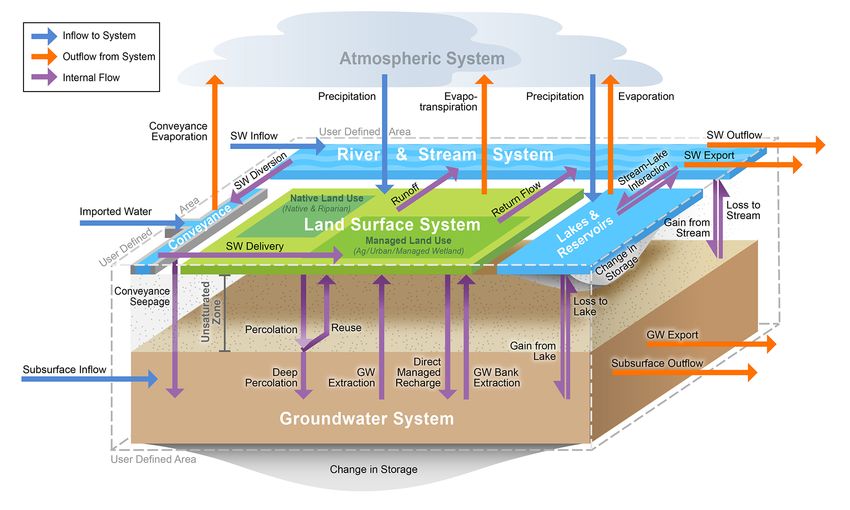
DRAFT Assumptions and Estimates

Acronyms and Abbreviations
Draft A&E Report                  Draft Assumptions and Estimates Report

Action Plan                       California Water Action Plan

Basin Study                       Central Valley Basin Study

BDO                               Bay Delta Office

BMP                               best management practice

C2VSim                            California Central Valley Groundwater-Surface Water Simulation Model

CAWU                              California Agricultural Water Use

CCTAC                             Climate Change Technical Advisory Committee

Central Coast region              Central Coast Hydrologic Region

DWR                               California Department of Water Resources

Framework                         Water Management Effectiveness Framework

GSA                               groundwater sustainability agency

Interim Update 2016               Bulletin 118 Interim Update 2016

IWFM                              Integrated Water Flow Model

LOCA                              Localized Constructed Analogues

PA                                planning area

Policy AC                         Policy Advisory Committee

PWSS                              Public Water System Statistics

QA/QC                             quality assurance/quality control

RCP                               Representative Concentration Pathway

Reclamation                       U.S. Bureau of Reclamation

Regional Atlas                    California Regional Water Management Atlas

RMS                               resource management strategy

Page ii                                                               California Department of Water Resources
California Water Plan Update 2018

RO                                   Region Office

SASC                                 State Agency Steering Committee

SGMA                                 Sustainable Groundwater Management Act

State Water Board                    State Water Resources Control Board

Strategic Data Framework             Strategic Vision and Framework for IWM Data and Tools

Tribal AC                            Tribal Advisory Committee

Tulare Lake region                   Tulare Lake Hydrologic Region

Update 2018                          California Water Plan Update 2018

WaDE                                 Data Integration and Implementation of Water Data Exchange

Water Code                           California Water Code

Water Plan                           California Water Plan

WBFP                                 Water Budget Framework Project

WEAP                                 Water Evaluation and Planning

WY                                   Water Year

California Department of Water Resources                                                                  Page iii

California Water Plan Update 2018

California Water Plan Update 2018
DRAFT Assumptions and Estimates
Introduction
The California Water Plan (Water Plan) is the State government’s strategic plan for sustainably managing
and developing water resources statewide for current and future generations. The Water Plan development
process provides a planning framework for elected officials, agencies, tribes, water and resource managers,
businesses, academia, stakeholders, and the public to collaborate on findings and recommendations and make
informed decisions regarding California’s water future. The goal for each update of the Water Plan is to
receive broad input and support from Californians, meet California Water Code (Water Code) requirements,
guide State investments, and advance integrated water management and regional sustainability.

This draft report and the related data posted online comprise the Draft Assumptions and Estimates Report
(Draft A&E Report) for California Water Plan Update 2018 (Update 2018). The Draft A&E Report presents
key assumptions and estimates, data and data sources, and companion plans that will be considered for the
preparation of Update 2018. The report increases the transparency of the Water Plan process by disclosing
the data, tools, methods, and references used to prepare Update 2018. This report meets Water Code
requirements, which stipulate that the California Department of Water Resources (DWR) must publish the
Water Plan’s assumptions and estimates one year prior to the plan’s publication, as well as provide an
opportunity for public review and comment. Water code requirements for the Draft A&E Report are
presented below.

The Draft A&E Report also describes the approach DWR is taking to improve the analytical tools and data
being used to develop Update 2018. DWR will continue to update Draft A&E Report content online during
the remainder of the Update 2018 development process. A draft glossary for Update 2018 is included as part
of this report, and the final version of that glossary will be published as a component of Update 2018. The
final data and data sources will be included in the Update 2018 reference and technical information.

Update 2018 Builds on the Legacy of Update 2013
For Update 2018, sustainability is envisioned not as an end point, but as an ongoing, resilient, and dynamic
balance among four societal values: (1) public health and safety, (2) a healthy economy, (3) ecosystem
vitality, and (4) opportunities for enriching experiences. This understanding of sustainability will help guide
the efforts necessary for effective integrated water management (IWM) and integrated regional water
management (IRWM). Both IWM and IRWM, fostered in California Water Plan Update 2013 (Update
2013), deliver on the Governor’s California Water Action Plan (Water Action Plan) and the landmark
Sustainable Groundwater Management Act (SGMA). They also advance regional sustainability planning. In
these ways, Update 2018 makes a leap in form and content from the foundation established in Update 2013
and in previous updates.

California Water Action Plan
The Water Action Plan underscores the need to respond to changing conditions and establishes three goals:
(1) achieving “more reliable water supplies”; (2) restoring “important species and habitat”; and (3) ensuring
“a more resilient, sustainably managed water resources system (water supply, water quality, flood protection,

California Department of Water Resources                                                                    Page 1
DRAFT Assumptions and Estimates

and environment) that can better withstand inevitable and unforeseen pressures in the coming decades”
(California Natural Resources Agency et al. 2016).

Sustainable Groundwater Management Act
SGMA, passed in 2014, requires water- and land-use agencies to come together in governance and develop
plans to sustainably manage groundwater — in the context of overall regional water sustainability. The
success of SGMA lies primarily with the regional agencies’ effective governance and their ability to balance
regional supplies and demands in a more sustainable way. DWR is responsible for implementing SGMA,
with the State Water Resources Control Board (State Water Board) intervening when regions are unable to
achieve sustainability.

Regional Sustainability Planning
The Water Plan provides a statewide water perspective and describes how various areas of California have
specific challenges related to water planning. A regional planning process, which focuses on regional
sustainability outcomes, is needed to achieve the statewide sustainability outcomes. For this reason, Update
2018 will be informed by the companion plan Managing for Regional Sustainability to provide the regional
perspective in developing State-level policy recommendations and priority actions.

Update 2018 will also draw on Stakeholder Perspectives — Recommendations for Sustaining and
Strengthening Integrated Regional Water Management, to be released by DWR in April, 2017. This report
describes a comprehensive set of actions recommended by stakeholders for sustaining and strengthening the
practice of IRWM in California. The report is based on extensive stakeholder input received during two
intensive rounds of facilitated workshops throughout the state, an assessment of IRWM planning and
implementation projects, and interviews with water managers and other experts from multiple State and local
organizations. The development of the report was guided by a stakeholder focus group consisting of IRWM
practitioners and representatives of California Native American Tribes, disadvantaged communities, and
water management associations.

Water Management Effectiveness Framework
Update 2018 is being developed using an integrated set of tools that increases the effectiveness of IWM and
IRWM and moves California toward a more sustainable future. The Water Management Effectiveness
Framework (Framework) is built on shared intent, or intended outcomes, of future water management actions
and policies. The Framework also recommends priorities for near-term State actions and investments.
Effective water management is achieved and sustained by establishing clearly defined, specific outcomes and
the proper metrics, or sustainability indicators, to track progress toward sustainability.

An important component of effective water management is identification of sustainable funding methods that
lead to more stable revenues. In preparing Update 2018, water resource managers, policy-makers,
stakeholders, and the public will be apprised of key State initiatives. The initiatives are incorporated into
five-year policy recommendations and priority actions, potential funding mechanisms/scenarios, and an
accompanying funding plan. An implementation plan will tie funding, actions, and schedule together with
implementing entities and performance measures — an innovative approach that builds on the Finance
Planning Framework and the Roadmap for Action of Update 2013.

The Framework is based on four overarching societal values, as well as sustainability indicators and related
assessments, which are required to make steady progress toward water sustainability. A legacy set of guiding

Page 2                                                                    California Department of Water Resources
California Water Plan Update 2018

principles from Update 2013 is reaffirmed in Update 2018, which help guide the balancing of the societal
values when trade-offs are required to achieve outcomes.

The success of the Framework goes hand in hand with planning and implementing actions at appropriate
geographic scales. Given the complexity within the flood and water management system and related natural
resources, and the fact that many agencies and organizations are responsible for various aspects of resource
management, DWR’s 2016 Strategic Business Plan proposes conducting water management planning and
implementation at the watershed (river basin and groundwater basin) scale. This ensures that the
interdependent conditions and functions within a watershed — including the physical, biological, economic,
and social processes — are understood and considered in an integrated manner.

California Water Code Requirements
State law (Water Code Section 10004.6) requires DWR to release this preliminary draft of the assumptions
and estimates upon which Update 2018 will be based, to interested persons and entities throughout the state
for their review and written or oral comments. DWR will closely consider the comments when adopting the
final assumptions and estimates for Update 2018. (See the inside front cover for guidance regarding how to
submit comments.)

Major Categories of Information Required by the Water Code
The Water Code requires the following major categories of information:
     • Basin hydrology.
     • Current and projected water use.
     • Groundwater supplies.
     • Evapotranspiration rates for major crops.
     • Current and projected water supplies provided by water recycling and reuse.
     • Current and projected adoption of urban and agricultural water conservation practices.
     • Environmental water needs.
     • Current and projected land-use patterns.
     • Current and projected population.

See detailed information about Water Code requirements on DWR’s A&E report web page.

Assumptions and Estimates
This section contains and briefly describes the primary assumptions and estimates of Update 2018, organized
according to the technical components below. Details of these components will be provided in the Update
2018 reference and technical information, which will support Update 2018 findings and recommendations.

Water Management Effectiveness Analysis and Sustainability Outlook
For Update 2018, the Water Plan Team will perform six activities to develop and implement the Framework.
     1. Define sustainability outcomes (level 4) in terms of the four societal values and identify
         sustainability indicators. These societal values (Public Health & Safety, Healthy Economy,
         Ecosystem Vitality, and Enriching Experiences) and the associated intended outcomes, were
         presented to the State Agency Steering Committee (SASC), Policy Advisory Committee
         (Policy AC), and Tribal Advisory Committee (Tribal AC) in a series of meetings and webinars and

California Department of Water Resources                                                                  Page 3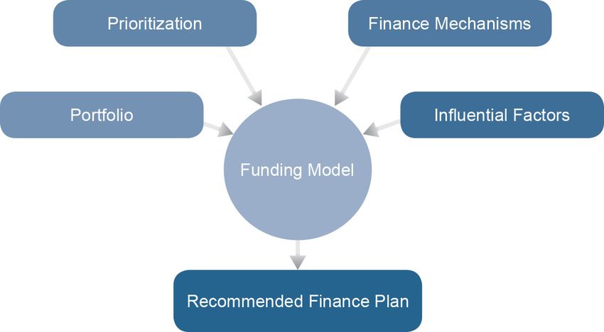
DRAFT Assumptions and Estimates

              are summarized in the California Water Sustainability Brochure. The Water Plan Team also is
              identifying indicators for tracking sustainability outcomes.
         2.   Develop a Water Management Effectiveness Assessment Survey. Consistent with level 4
              indices, the Water Plan Team has developed survey questions for a Water Management
              Effectiveness Assessment to evaluate the effectiveness of current water programs and projects at
              achieving the level 4 outcomes statewide.
         3.   Prepare a Water Sustainability Outlook. Using the survey results and professional judgment,
              the Water Plan Team will prepare a draft Sustainability Outlook — a narrative and graphical
              representation of the current status, trends, and gaps for each of the level 4 outcomes.
         4.   Identify Resource and Societal Benefits (level 3) and associated indices. The Water Plan Team
              will identify level 3 outcomes for each level 4 outcome and its corresponding indices. Indices
              (indicators) will be used to track and compare actual versus intended outcomes. These indices
              could be used to assess measurable changes in natural resource conditions and benefits to society.
         5.   Develop recommendations to overcome gaps and implementation challenges. Gaps and
              implementation challenges that are identified from the Water Management Effectiveness
              Assessment will inform water policy recommendations, including strategies to align and improve
              water governance, finance, and regulations.
         6.   Present assessment results and draft recommendations. The Water Plan Team will present
              early assessment results and preliminary work on the recommendations to the SASC, Policy AC,
              Tribal AC, and interested members of the public, in preparation for the Update 2018 engagement
              meetings in early 2017.

Groundwater Information and SGMA Activities
As required in Water Code Section 10004.6(c)(2), the Water Plan provides the public with information on
groundwater supplies. The SGMA effort will include estimates of sustainable yield and supplies necessary
for recovery of critically overdrafted basins beginning in 2020 and remaining high- and medium-priority
basins beginning in 2022.

DWR is developing a set of statewide data and tools to assist groundwater sustainability agencies (GSAs) to
assess water conditions and take appropriate actions toward sustainability. This includes tools for local
agencies to report information associated with basin boundary modifications, GSA formation, adjudicated
basin water supplies and uses, alternative plans, and groundwater sustainability plans. DWR will provide
statewide data sets on groundwater levels, groundwater quality, well completion reports, land use, land
subsidence, and water use. All of this information will be available to the public.

California's Groundwater Update 2013: A Compilation of Enhanced Content for California Water Plan
Update 2013 provides a comprehensive characterization of groundwater conditions and governance in each
hydrologic region. This update, with SGMA activities, provides a current view of the issues and potential
actions/activities that can be undertaken to address regional groundwater challenges.

Update 2013 included more enhanced groundwater content than did previous Water Plans. The related effort
was not intended to solve or address all the statewide and regional issues related to groundwater. It was
intended as a starting point to bring all the available information together from a statewide and regional
perspective.

Page 4                                                                        California Department of Water Resources
California Water Plan Update 2018
Communities That Rely on Contaminated Groundwater Source for Drinking Water, published by the State
Water Board in 2013, identifies the principal contaminants in the groundwater relied on by the affected
communities. The report discusses contamination levels, potential solutions, and funding sources to clean up
or treat groundwater or to provide alternative water supplies to ensure the provision of safe drinking water to
affected communities. The Groundwater Sustainability Program was established by Proposition 1 to prevent
and clean up contamination of groundwater and supplies lost to pollution and to help local agencies develop
their GSPs.
SGMA significantly expands DWR’s roles and responsibilities related to groundwater management.
Essential information and companion plans developed to implement SGMA, and which will support the
Draft A&E Report, are described below.
The Sustainable Groundwater Management Program Draft Strategic Plan describes DWR’s vision, as well
as roles and responsibilities to help implement SGMA. The draft plan outlines actions DWR will undertake
over the next several years to develop capacity that will better support local agencies across California in
their efforts to achieve sustainable groundwater management.
Bulletin 118 Interim Update 2016 (Interim Update 2016) discusses critically overdrafted groundwater basins
and basin boundaries. An addendum to Interim Update 2016, which is expected to be released in 2017, will
include updated basin prioritizations. A comprehensive update of Bulletin 118 will be published in 2020.
DWR has released a set of five documents under the title Best Management Practices for the Sustainable
Management of Groundwater, which, along with other guidance documents, will inform Update 2018. In this
context, “best management practice” (BMP) refers to a practice, or combination of practices, designed to
achieve sustainable groundwater management. These BMPS, determined to be technologically and
economically effective and practicable, are based on best available science. The BMP categories are:
• BMP 1: Monitoring Protocols, Standards, and Sites.
• BMP 2: Monitoring Networks and Identification of Data Gaps.
• BMP 3: Hydrogeologic Conceptual Model.
• BMP 4: Water Budget.
• BMP 5: Modeling.
Guidance documents are prepared for topic areas unique to SGMA, for topics where no established practices
in the water management industry exist and which may not have been specifically identified in the GSP
regulations. The guidance documents currently include:
• Preparation Checklist for GSP Submittal.
• GSP Annotated Outline.
The Draft Water Available for Replenishment Report, published in January, 2017, presents DWR’s best
estimate, based on available information, of water available for replenishment of groundwater in the state,
consistent with Water Code Section 10729(c).
Strategic Data Framework
DWR’s Strategic Vision and Framework for IWM Data and Tools (Strategic Data Framework) is founded on
an overarching strategic vision.
California Department of Water Resources Page 5DRAFT Assumptions and Estimates
“DWR’s water information is organized and integrated such that it is universally accessible and supports
watershed-based water budgets for IWM.”
As shown in Figure 1, the Strategic Data Framework includes robust data collection by DWR, transparent
data reporting to DWR by local agencies, and enterprise data management and exchange. It documents the
associated vision and objectives. It also includes actions that DWR’s Division of Integrated Water
Management and Division of Statewide Integrated Water Management can take to implement the Strategic
Data Framework. The resulting data, analysis, and tools will help support and track progress toward the
ultimate outcome of sustainable water management as articulated in the Water Action Plan and SGMA.
Figure 1 Strategic Data Framework
Water budgets and related data collection, reporting, management, and exchange are crucial to the successful
implementation of many DWR programs. The Strategic Data Framework aims to connect DWR programs to
support achieving the sustainable water management goals of the Water Action Plan and SGMA.
Page 6 California Department of Water ResourcesCalifornia Water Plan Update 2018
Collaboration and alignment with other federal, State, and local agencies that collect and share data will be
essential to the implementation and refinement of the Strategic Data Framework. In summary, the Strategic
Data Framework:
• Describes the current conditions for data, tools, and water budget methods used by Division of
Integrated Regional Water Management and Division of Statewide Integrated Water Management.
• Summarizes legislation and other drivers, including the Water Action Plan and SGMA.
• Describes key outputs and outcomes that will result from implementing the Strategic Data
Framework.
• Defines vision, objectives, and actions included in the Strategic Data Framework to support the
implementation of SGMA and the Water Action Plan.
• Identifies the cross-cutting actions, such as standards and protocols, communication and outreach,
and long-term funding, for implementing the Strategic Data Framework.
Visions for the four organizing elements of the Strategic Data Framework — data collection, data reporting,
data management and exchange, and water budget methods — and their associated objectives and actions
were developed through input and validation from DWR staff. A phased implementation timeline of the
actions was also developed. Those actions support the key outcomes of sustainable water management.
Water Budgets
DWR has developed the Water Budget Framework, which builds on the Water Plan’s water budget
methodology, to implement the vision for water budget methods developed by DWR staff in 2016: “DWR
has a defensible method for estimating watershed-based water budgets that allows for flexible spatial and
temporal scales; can be utilized by GSAs and local agencies; and leads toward consistent water budgets
developed by local, State, and federal agencies, and tribal entities” (California Department of Water
Resources 2016).
The Water Budget Framework is developed for the overlying watersheds of groundwater basins and
administrative boundaries, such as GSAs, detailed analysis units (DAUs)/counties, and planning areas (PAs)
in California. It is a collaborative effort by DWR staff from various programs and offices, including the
Water Plan, Sustainable Groundwater Management Program, Bay Delta Office, and Region Offices. The
Water Budget Framework will support implementation of SGMA and the transition of the Water Plan’s
water supply and balance computations to watershed-based water budget methods. The Water Budget
Framework has the following goals:
• Identify inconsistencies in water budget terms and methods used by DWR programs, and make
recommendations to resolve these inconsistencies so all DWR water budget terms and methods
will align with the GSP regulations.
• Identify a process to improve the Water Portfolio Method used in the Water Plan for estimating
water budgets at appropriate spatial and temporal scales relevant to SGMA and future Water Plan
updates.
• Develop recommendations on how Region Office staff can best coordinate with and provide
technical assistance to local GSAs regarding water budget requirements. Region Office staff
should expand knowledge of how existing local water-budget data and information can be utilized
to develop preliminary water budgets by groundwater basins.
• Develop a generalized water budget framework for use by DWR, GSAs, and the local agencies to
develop total water budgets at different spatial and temporal scales.
California Department of Water Resources Page 7DRAFT Assumptions and Estimates
Water budget framework development includes two pilot studies: (1) Tulare Lake Hydrologic Region (Tulare
Lake region) Pilot and (2) Central Coast Hydrologic Region (Central Coast region) Pilot. The pilot studies
will be completed in two phases.
1. Phase I focuses on evaluating the current state of water budget data and methods and developing a
consistent water budget method, with a common vocabulary, by using the Tulare Lake region as a
test case.
2. Phase II focuses on refining the Tulare Lake region pilot, testing the consistent water budget
method on the Central Coast region, and refining the Water Budget Framework for use in other
hydrologic regions of California.
The results of Phase I will be included in Update 2018.
Evaluated Models and Data
The models and tools listed in Table 1 were evaluated to inform water budget framework development.
Table 1 Models Evaluated for Developing the Water Budget Framework
Name Description Source
IWFM IWFM (Integrated Water Flow Model) is a water resources management and planning DWR
model that simulates groundwater, surface water, stream-groundwater interaction, and
other components of the hydrologic system.
C2VSim The California Central Valley Groundwater-Surface Water Simulation Model (C2VSim) is an DWR
IWFM integrated numerical model that simulates water movement through the linked land
surface, groundwater and surface water flow systems in California’s Central Valley.
Water portfolio Developed as part of the Water Plan, the water portfolio paints a picture of the water supply DWR
and use for a given year statewide or by region, subject to availability of data. It includes a
flow diagram and table, a developed water supply and use balances, and a summary table.
Data are developed for DAU/County subareas, PA, and hydrologic regions.
Cal-SIMETAW The Cal-SIMETAW model estimates the daily soil water balance to determine crop DWR
evapotranspiration for use in the Water Plan. The model requires weather data, soils, crop
coefficients, rooting depths, seepage, etc., which influence crop water balance.
CAWU The California Agricultural Water Use (CAWU) Model uses monthly reference evaporation DWR
or evapotranspiration, crop coefficient, crop irrigation data to simulate monthly volumes of
on-farm crop consumptive use and applied water for 20 crop categories by DAU/County for
the Water Plan.
Notes:
C2VSim = California Central Valley Groundwater-Surface Water Simulation Model, CAWU = California Agricultural Water Use, DAU =
detailed analysis unit, IWFM = Integrated Water Flow Model, PA = planning area, Water Plan = California Water Plan
The California Central Valley Groundwater-Surface Water Simulation Model (C2VSim) model covers
Central Valley’s groundwater basins extending from Redding to Bakersfield, including the valley floor
within the Tulare Lake region. The C2VSim model area is divided into 21 model subregions, eight of which
are within the Tulare Lake region. The C2VSim water budget outputs are generated by model subregions.
Figure 2 shows a close relationship between the C2VSim model subregions and the Water Portfolio PA, thus
facilitating water budget comparisons and assessments. Data in the C2VSim model come from multiple
sources, including the Water Plan, reported numbers, and historic calibrations by the Bay Delta Office.
Page 8 California Department of Water ResourcesCalifornia Water Plan Update 2018
Figure 2 Water Plan Water Portfolio Planning Areas and C2VSim Model Subregions
California Department of Water Resources Page 9DRAFT Assumptions and Estimates
Data Mapping Between C2VSim and Water Plan Water Portfolio
During development of the Strategic Data Framework, the data elements for water budget components used
by DWR programs were identified through a series of workshops that included input from about 60 DWR
staff. This effort concluded that the Bay Delta Office (developers of the Integrated Water Flow Model
[IWFM] and C2VSim) and the Water Plan (developers of the Water Portfolio Method) are the two programs
that include all relevant water budget terms.
A work team of representatives from the Water Plan and the Bay Delta Office examined the water budget
components of water portfolios and IWFM/C2VSim to develop mapping and transformation formulas
between the water budget components of each method. This effort focused on water budget component and
data parameter similarities and differences to develop recommendations for necessary components of a total
water budget framework.
Water portfolios provide a detailed annual assessment of developed water supplies and uses for three sectors:
agricultural, urban, and environmental. C2VSim extends the concepts used in water portfolios by adding
exchanges and interactions among water subsystems on a monthly time scale. It does this by generating four
water budgets for user-defined model subregions.
1. Land and Water Use Budget.
2. Root Zone Budget.
3. Groundwater Budget.
4. Stream Budget.
These four water budgets comprise the total water budget for the watershed and underlying groundwater
basins.
To correlate between the two methods, data mapping between C2VSim and water portfolios was conducted
for the four water budgets from C2VSim. This process identified inconsistencies in the definitions of the
water-budget-related terms and how they are used in C2VSim and water portfolios. In addition, the data
requirements and output needed for water portfolios formed the basis for several recommendations to
enhance the IWFM.
Common Schematic and Vocabulary for the Water Budget Framework
The inconsistencies and incompleteness of definitions for water-budget-related terms in both C2VSim and
water portfolios are addressed by creating the total water-budget system schematic shown in Figure 3, to
depict interrelationships among different components of the total water budget.
Page 10 California Department of Water ResourcesCalifornia Water Plan Update 2018
Figure 3 Total Water Budget Schematic
Water Budget Dashboards
Graphical and map-based visualization dashboards are implemented for communicating water budget data
and information to stakeholders. Water budget dashboards offer a visual representation of water budget
components to enhance understanding of the physical processes in a watershed and underlying groundwater
basins. It also allows the flexibility to visualize important water budget components in an interactive manner
and develop shared understanding. Water budget data from future scenario analysis by both DWR and GSAs
can also be visualized in such dashboards, and used by GSAs for planning purposes.
Water Portfolios
The Water Plan presents information about recent statewide and regional water conditions through water
portfolios and water balances. Water portfolios and balances describe the distribution of water throughout the
hydrologic cycle, water use by the urban and agricultural sectors, water in the environment, and water supply
sources used to meet these uses. A primary reason for water portfolio and balance data is to estimate an
accounting of all water that enters and leaves the state and how it is used in and exchanged between the
regions. This information is foundational for all water planning activities, including IRWM. The information
also will assist regions with developing and pursuing relevant and achievable water management objectives.
Water portfolio data support programs and agencies responsible for performing water analysis and planning,
and disseminating water-related information. Water portfolios provide detailed information about statewide
water supply sources and estimates for the primary uses of the state’s supplies. Water portfolios and balances
are developed by DAU/Counties and aggregated to PA, hydrologic region, and statewide summaries. Maps
of these areas are available on DWR’s GIS and Maps web page.
California Department of Water Resources Page 11DRAFT Assumptions and Estimates
Update 2018 will include information for Water Years (WYs) 1998–2015, expanding Update 2013’s water
portfolio information by five water years. The five-year period of WYs 2011–2015 began with a wet year,
then became dry, and then critical, based on the eight-river index, with a drought declared during WY 2014.
Water portfolio data provide information for comparison about how water uses and sources of supply can
vary among wet, average, and dry hydrologic conditions for each of the hydrologic regions. Water portfolio
data will be presented in Update 2018 reference and technical information. The following major categories of
water portfolio content are included in the Water Plan:
• Local deliveries.
• Residential interior and exterior water use.
• Large landscape water use.
• Local imported deliveries.
• Commercial and industrial water use.
• Reuse of water.
• Colorado River deliveries.
• Large landscape water use.
• Recycled water.
• Central Valley Project deliveries.
• Evaporation and evapotranspiration of applied water for agriculture.
• Evaporation and evapotranspiration of applied water for managed wetlands.
• Other federal deliveries.
• Groundwater recharge of applied water.
• Required instream flow.
• State Water Project deliveries.
• Deep percolation to a salt sink.
• Required Sacramento-San Joaquin River Delta outflow.
• Groundwater extraction.
• Conveyance system irrecoverable water.
• Wild and Scenic River flows.
For Update 2018 and beyond, water supply and use teams are working on pilot projects related to water
portfolio data and technological improvements. For WY 2014, land use and irrigated acres information
derived by means of remote sensing will be compared with existing land-use survey data for agricultural
water-use analysis. Staff continues to improve the agricultural water-use model, Cal-SIMETAW, with
updated and improved input data, including crop coefficients. A recycled water sub-group has been formed
and is collaborating regularly with the State Water Board to incorporate more current municipal recycled
water data and information to the water portfolios by using the 2015 Recycled Water Use Survey.
A pilot project is also underway for urban water-use analysis. Because of increased State Water Board
requirements beginning in WY 2013, public water system (reported) data has increased substantially. A more
automated process is being implemented for WY 2014 urban per-capita water use analysis, which uses
Python scripting to dynamically access public water system data straight from a database instead of
extracting data in spreadsheets. This process allows for quality assurance/quality control (QA/QC) directly in
the database, as well as linking the system service areas directly to the Public Water System Statistics
(PWSS) data in a geo-database.
A database development pilot project is underway for WY 2010 water portfolio inflow-outflow data entry
worksheets. DWR is working in partnership with the Western States Water Council and the U.S.
Page 12 California Department of Water ResourcesCalifornia Water Plan Update 2018 Environmental Protection Agency on the Data Integration and Implementation of Water Data Exchange (WaDE) Dataflow project, which provides a platform for additional coordination and shared meaning in conjunction with California’s priorities, U.S. Geological Survey (Water Availability and Use Science Program), and the SECURE Water Act (Section 9508, Public Law 111-11). This DWR database pilot project, in collaboration with the San Diego Supercomputer Center, uses the PostgreSQL database management system and the WaDE database schema. The WY 2010 data currently are served publicly through the WaDE database, using an API (application programming interface) as well as web-services for integration with contemporary geographic information systems. Integration with other databases will depend on the semantics of each database, but PostgreSQL has export/import capabilities that facilitate a high degree of interoperability with other systems. There are no current plans for integration with other databases, though that could be a natural extension of this work and part of the Strategic Data Framework and the Water Budget Framework. Database advancements will lead to more efficient and effective data exchange; QA/QC; and querying and reporting of data, including data reporting/translation at numerous spatial scales. The Strategic Data Framework includes having DWR’s water information organized and integrated such that it is universally accessible and supports watershed- based water budgets for IWM. These advances will also help implementation of Assembly Bill 1755 — Open Data Platform. Visit DWR’s Water Portfolio web page for more information and data about water portfolios and water balances. Detailed information for WYs 1998–2010 is available in the Update 2013 Technical Guide. Data for WYs 1998–2015 will be available in Update 2018 reference and technical information. Climate Change The climate change analysis for Update 2018 consists of developing climate data inputs (monthly temperature, precipitation, and wind speed) for 20 new climate scenarios to be run using the Water Evaluation and Planning (WEAP) PA model for California’s Central Valley, as well as a hydrologic region model for seven non-Central Valley hydrologic regions. These 20 climate scenarios were recommended by DWR’s Climate Change Technical Advisory Committee (CCTAC). Ten global climate models have been selected that best simulate climate conditions important for California water management and planning. Each of the 10 models is run with two greenhouse gas forcing scenarios or Representative Concentration Pathways (RCPs), one representing an optimistic future in which large-scale greenhouse gas mitigation efforts are implemented (RCP 4.5) and one business-as-usual future (RCP 8.5). Climate scenarios use the newest statistical downscaling methodology, Localized Constructed Analogues (LOCA), which has been endorsed for use by the California 4th Climate Change Assessment. Climate scenarios provide monthly time-series information for the years 1950–2099. The 20 projections explore a range of temperature change by late-century (2070) conditions of 3.1 to 9.2 degrees Fahrenheit and precipitation change from a decrease of 13.9 percent to an increase of 36.7 percent throughout the Central Valley. Future Scenarios In previous Water Plan updates, most of the future water supply and demand scenarios were limited to mid-century projections (2050). In Update 2018, the plan is to extend the projections to the end of the century (2100). The future water conditions will be evaluated under multiple scenarios of future demographics, land use, and new updated climate projections. The new climate scenarios, as explained above California Department of Water Resources Page 13
DRAFT Assumptions and Estimates
in the “Climate Change” section, will be based on the results of 10 Global Circulation Models driven by two
RCP greenhouse gas radiative-forcing scenarios: 4.5 W/m2 and 8.5 W/m2. The resulting 20 future climate
scenarios include a range of future temperature and precipitation conditions.
The urban population growth and land use scenarios in Central Valley will be based on the Central Valley
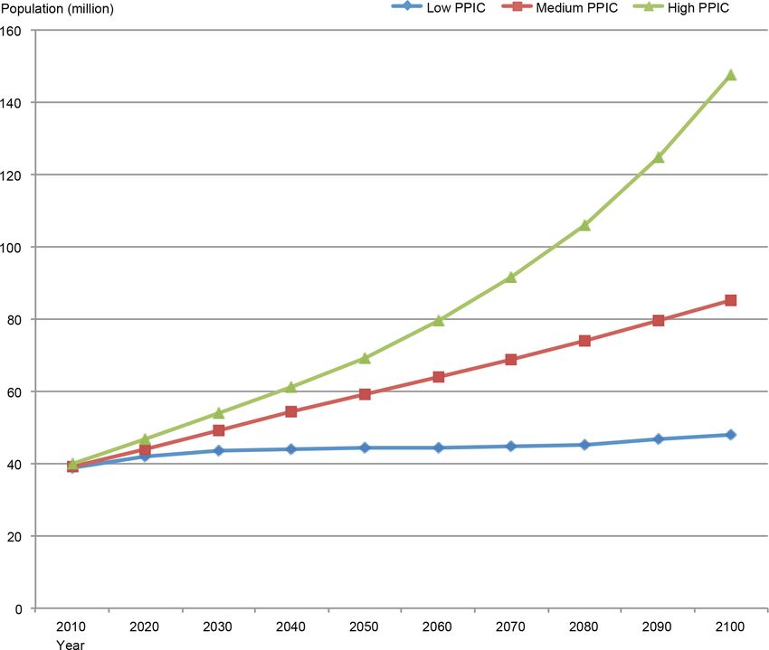
Basin Study (Basin Study) conducted by U.S. Bureau of Reclamation (Reclamation). Figure 4 shows long-
term future statewide population projections under three Public Policy Institute of California scenarios —
low, medium, and high — from the years 2010 to 2100.
Figure 4 Statewide Future Population Projections (2010–2100)
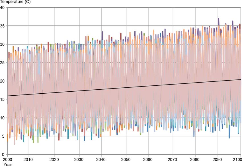
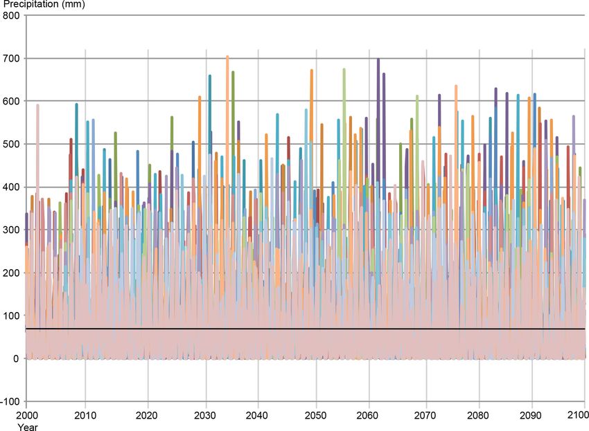
Figures 5 and 6 show long-term time series (2000–2100) and ranges of future temperature and precipitation
variations for the 20 climate scenarios in a sample location within the Sacramento River Hydrologic Region.
Page 14 California Department of Water ResourcesCalifornia Water Plan Update 2018 Figure 5 Future Temperature Projections for the Sacramento River Hydrologic Region (2000–2100) California Department of Water Resources Page 15
DRAFT Assumptions and Estimates

Figure 6 Future Precipitation Projections for the Sacramento River Hydrologic Region (2000–2100)

In Update 2013, several management response packages were evaluated for a range of future water supply
and demand conditions by using robust decision-making for Central Valley regions at mid-century (year
2050 level). In Update 2018, an analysis of long-term water supply and demand conditions (year 2100 level),
along with statistical occurrences of the demand-not-met (likelihood of unmet demand), will be performed.
The analysis for the remaining seven hydrologic regions in California will be at the hydrologic region level
and will focus on quantifying long-term projections (2100) of future water demand.

These key activities related to future scenarios:
     • Develop long-term scenarios of future climate conditions (precipitations, temperature, etc.),
         extended to year 2100 for the Central Valley hydrologic regions (Sacramento, San Joaquin, and
         Tulare Lake) PAs, with advice from DWR’s CCTAC.
     • Develop long-term scenarios (year 2100) of future urban growth and land use in Central Valley
         PAs, based on Reclamation’s Basin Study.
     • Quantify future water supply and demand conditions and statistical occurrences of potential unmet
         demands for the Central Valley PAs under the 20 future climate and five urban growth and land
         use scenarios.

Page 16                                                                  California Department of Water Resources
California Water Plan Update 2018
This additional analysis may also be conducted:
• Develop similar long-term future climate, urban growth, and land use scenarios for the remaining
seven hydrologic regions. Quantify long-term future water demand conditions for the seven non-
Central Valley hydrologic regions.
California Regional Water Management Planning
The Update 2013 regional reports provide a comprehensive description of each hydrologic region. The effort
was intended as a starting point to bring all of the available information together from a regional perspective.
Update 2018 will be informed by this previous work. These regional reports, along with the California
Regional Water Management Atlas (Regional Atlas) described below, will provide an up-to-date view of the
issues involved, as well as the potential actions/activities that can be performed, to address regional
challenges and meet Water Code Section 10013.
Update 2018 will contain a Regional Atlas, as an online information platform for local entities to
continuously update information about projects in their representative area. Representative areas can include
various governance entities, such as IRWM planning regions, GSA service areas, flood management
agencies, and counties/cities. The initial focus will be on developing the platform and receiving content from
IRWM planning regions.
The Regional Atlas will also summarize each of the area’s unique information on the current water supplies
and uses, as well as a discussion of water issues, current and proposed regional water projects,
accomplishments, and challenges. In particular, it will include steps that have been taken to improve water
supplies to meet municipal, agricultural, and environmental water needs, and to minimize the need to import
water from other hydrologic regions and the Delta.
The potential content for each IRWM region includes:
• Description of the IRWM region. This section includes a description of the location, regional
boundaries, total population, and total area of the region. In addition, it includes their type of
governance and a summary their grant program history.
• Water resource management challenges and objectives. Descriptions of the biggest challenges
of the region and the planning strategy for achieving objectives and goals. This includes water
supply, demand, and issues, as well as such issues as water quality, groundwater management,
environmental stewardship, climate change, and flood management.
• IRWM region’s demographics. Descriptions of disadvantaged communities, stakeholders, and
California Native American Tribes within the region.
Resource Management Strategies
The Water Plan provides a broad set of resource management strategies (RMSs) that can help local agencies
and governments manage their water and related resources. An RMS can be a technique, program, or policy
used to meet water-related management needs of a region and the state as a whole. While recognizing
interdependencies among many of the strategies, the Water Plan’s 30-plus RMSs provide a comprehensive
suite of tools that can be used to achieve a variety of intended outcomes by utilizing a diverse mix of
strategies.
Just as the mix of tools in any given kit depends on the job to be accomplished, the combination of strategies
will vary from region to region, depending on climate, projected growth, existing water system(s),
California Department of Water Resources Page 17DRAFT Assumptions and Estimates
environmental and social conditions, and regional goals. At the local level, it is important that the proposed
strategies complement the operation of existing water systems. Some strategies may have little value in
certain regions. For example, because of geology, the opportunity for groundwater development in the Sierra
Nevada is not nearly as significant as in the Sacramento Valley. Other strategies may have little value under
particular conditions. For example, precipitation enhancement may not be effective during droughts. Water
managers at different geographical scales will have different perspectives on the assortment and cost-
effectiveness of RMSs for meeting the needs and priorities of the locality or the region, or the entire state.
In Table 2, the RMSs are organized alphabetically under eight water management objectives, with
descriptions of their primary objective and emphasis.
Table 2 Resource Management Strategies and Management Objectives
Reduce Water Demand Improve Water Quality
Agricultural Water Use Efficiency Drinking Water Treatment and Distribution
Urban Water Use Efficiency Groundwater/Aquifer Remediation
Improve Operational Efficiency & Transfers Matching Water Quality to Use
Conveyance — Delta Pollution Prevention
Conveyance — Regional/Local Salt and Salinity Management
System Reoperation Urban Stormwater Runoff Management
Water Transfers Practice Resource Stewardship
Increase Water Supply Agricultural Land Stewardship
Conjunctive Management and Groundwater Storage Ecosystem Restoration
Desalination (Brackish and Sea Water) Forest Management
Precipitation Enhancement Land Use Planning and Management
Municipal Recycled Water Recharge Area Protection
Surface Storage — CALFED Sediment Management
Surface Storage — Regional/Local Watershed Management
Improve Flood Management People & Water
Economic Incentives — Loans, Grants, and Water
Flood Management
Pricing
Other Strategies Outreach and Education
Crop idling, dewvaporation, fog collection, irrigated land Water and Culture
retirement, rainfed agriculture, and waterbag transport Water-Dependent Recreation
Companion State Plans
The Water Plan’s list of State government plans related to water resources has grown to more than 190. From
that list, the featured plans most pertinent to the Water Plan will be identified. As in Update 2013, the
featured companion State plans will be used to inform policy recommendations and short- and long-term
actions in Update 2018. The Water Plan committees will work collaboratively to develop the key policy
recommendations and actions that will be set forth in Update 2018.
Funding Plan
The funding plan will be developed using tools to prioritize near-term investment needs leading to
recommended opportunities and options for sustainable funding. The plan will include analysis of potential
Page 18 California Department of Water ResourcesCalifornia Water Plan Update 2018
funding scenarios on a geographic basis, to prioritize action types (high, medium, or low) based on
applicability, reliability, and political viability.
Many uncertainties will affect future water management investments; the financial analysis will consider
these uncertainties as constraints. The funding plan explores ways to fund proposed capital and ongoing
investments with varied assumptions about these factors: prioritized management types; the availability of
existing and new funding mechanisms; and other influencing factors, such as ability to pay or cost-share
agreements. The resulting investment portfolio will be organized and presented by thematic area and
management action type.
The spreadsheet funding model, shown in Figure 7, will identify the most viable, reliable, and applicable
funding mechanisms. The tool maximizes overall funding subject to the constraints for each scenario. Each
scenario is based on a different set of assumptions, from a continuation of historical trends to a more
optimistic future.
Figure 7 Development of a Funding Plan
California Department of Water Resources Page 19California Water Plan Update 2018
Useful Web Links
Best Management Practices for the Sustainable Management of Groundwater (DWR 2016)
http://www.water.ca.gov/groundwater/sgm/bmps.cfm
Bulletin 118 Interim Update 2016 (DWR 2017)
http://www.water.ca.gov/groundwater/bulletin118/docs/Bulletin_118_Interim_Update_2016.pdf
California's Groundwater Update 2013: A Compilation of Enhanced Content for California Water Plan
Update 2013 (DWR 2014)
http://www.water.ca.gov/waterplan/topics/groundwater/index.cfm
California Water Action Plan
http://resources.ca.gov/california_water_action_plan/
California Water Code requirements
http://www.water.ca.gov/waterplan/technical/waterplancode.cfm
California Water Plan Update 2013
http://www.water.ca.gov/waterplan/cwpu2013/final/
California Water Plan Update 2013 Technical Guide
http://www.water.ca.gov/waterplan/technical/cwpu2013/index.cfm
California Water Plan Update 2018
http://www.water.ca.gov/waterplan/cwp/update2018/index.cfm
California Water Sustainability Brochure (Water Plan)
http://www.water.ca.gov/waterplan/docs/cwpu2018/01_Update2018_Sustainability_Brochure_Letter
.PDF
Communities That Rely on Contaminated Groundwater Source for Drinking Water (State Water Board 2013)
http://www.waterboards.ca.gov/gama/ab2222/docs/ab2222.pdf
Draft Assumptions and Estimates Report (Update 2018)
http://www.water.ca.gov/waterplan/cwp/update2018/ae/
Draft Glossary for Update 2018
http://www.water.ca.gov/waterplan/cwp/update2018/ae/
California Department of Water Resources Page 21DRAFT Assumptions and Estimates
Draft Water Available for Replenishment Report (DWR 2017)
http://www.water.ca.gov/groundwater/sgm/pdfs/Draft_Water_Available_For_Replenishment_Report
.pdf
Draft Water Plan Companion Plan List (Update 2018)
http://www.water.ca.gov/waterplan/docs/cwpu2018/ae/04_Update2018_Draft_CompanionPlan_List.
pdf
Finance Planning Framework (Update 2013)
http://www.water.ca.gov/waterplan/docs/cwpu2013/Final/08_Vol1_Ch07_Finance_Planning_Frame
work.pdf
GIS and Maps (Water Plan)
http://www.water.ca.gov/waterplan/gis/index.cfm
Managing for Regional Sustainability (DWR 2017)
Unpublished.
Recommended Actions — Stakeholder Perspectives on Sustaining and Strengthening Integrated Regional
Water Management (DWR 2017)
Unpublished.
Road Map for Action (Update 2013)
http://www.water.ca.gov/waterplan/docs/cwpu2013/Final/09_Vol1_Ch08_Roadmap-For-Action.pdf
Strategic Business Plan (DWR 2016)
http://www.water.ca.gov/docs/Strategic%20Business%20Plan_Final.pdf
Sustainable Groundwater Management Act
http://groundwater.ca.gov/
Sustainable Groundwater Management Program Draft Strategic Plan
http://www.water.ca.gov/groundwater/sgm/pdfs/DWR_GSP_DraftStrategicPlanMarch2015.pdf
Water Management Effectiveness Framework
http://www.water.ca.gov/waterplan/docs/cwpu2018/01_Update2018_WMEF_Overview.pdf
Water Portfolios (Water Plan)
http://www.water.ca.gov/waterplan/topics/water_portfolios/index.cfm
Page 22 California Department of Water ResourcesYou can also read