Strategic Beach Management Plan: Northeast Atlantic Coast Region - Office of Resilience and Coastal Protection Florida Department of Environmental ...
←
→
Page content transcription
If your browser does not render page correctly, please read the page content below
Strategic Beach Management Plan:
    Northeast Atlantic Coast Region
   Office of Resilience and Coastal Protection
Florida Department of Environmental Protection
                   April 2020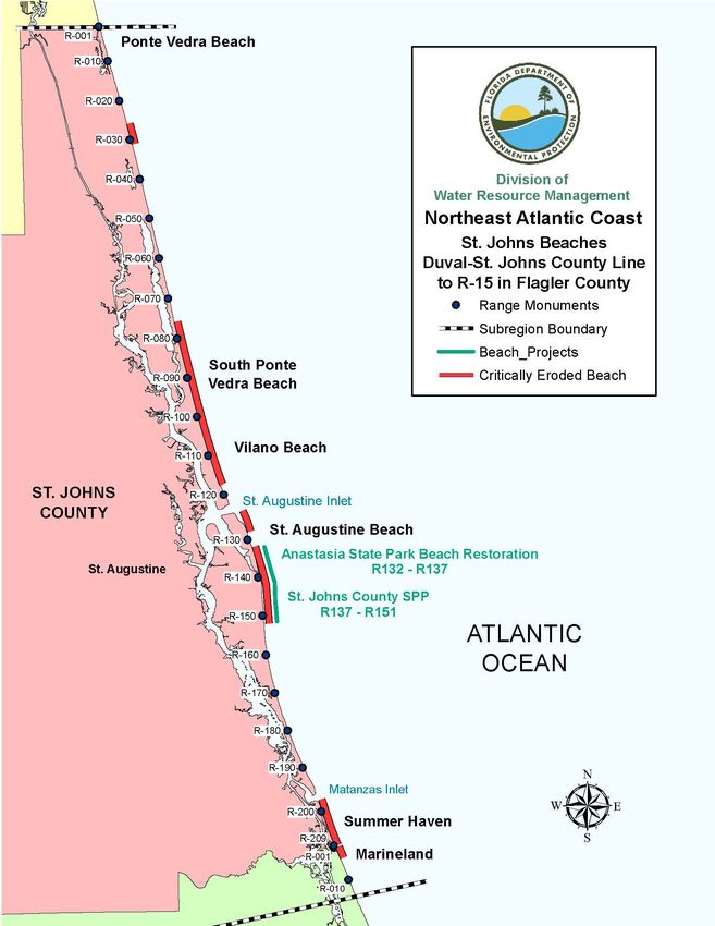
Florida Department of Environmental Protection, Strategic Beach Management Plan – Northeast Atlantic Coast Region

Table of Contents
Introduction - Northeast........................................................................................................................... 1
Sea Islands ................................................................................................................................................. 2
   Strategies for Inlets and Critically Eroded Beaches .......................................................................... 2
       St. Marys River Entrance, Nassau County .......................................................................................... 2
       Fort Clinch, Nassau County, 2,500 feet west of R1-R9 ...................................................................... 3
       Fernandina Beach, Nassau County, R9-R33 ....................................................................................... 4
       South Amelia Island, Nassau County, R60-R80 ................................................................................. 5
       Nassau Sound, Nassau County R79 to Duval County R1 ................................................................... 6
       Little Talbot Island State Park, Duval County, R21-R23.................................................................... 7
       Fort George Inlet, Duval County, R25-R26 ........................................................................................ 7
       St. Johns River Entrance, Duval County, R30-V501 .......................................................................... 8
       St. Johns River to the Duval - St. Johns County Line, Duval County, V501-R80 ............................. 8
   Regional Strategies for Beach and Inlet Management .................................................................... 10
       Sponsors and Funding ....................................................................................................................... 10
       Project Coordination.......................................................................................................................... 11
       Environmental Protection .................................................................................................................. 11
       Sand Sources ..................................................................................................................................... 12
       Additional Information ...................................................................................................................... 12
References ................................................................................................................................................ 14
St. Johns Beaches .................................................................................................................................... 17
   Strategies for Inlets and Critically Eroded Beaches ........................................................................ 17
       Ponte Vedra, St. Johns County, R26-R31 ......................................................................................... 17
       South Ponte Vedra Beach and Vilano Beach, St. Johns County, R76–R117.5................................. 17
       St. Augustine Inlet, St. Johns County, R122-R123 ........................................................................... 19
       Anastasia State Park and St. Augustine Beach, St. Johns County, R123-R128 and R132–R152..... 19
       Matanzas Inlet, St. John’s County, R196-R197 ................................................................................ 21
       Summer Haven, St. Johns County, R197-R209 ................................................................................ 21
       Marineland, Flagler County, R1-R4 .................................................................................................. 23
   Regional Strategies for Beach and Inlet Management .................................................................... 23
       Sponsors and Funding ....................................................................................................................... 23
       Project Coordination.......................................................................................................................... 23

April 2020, Page i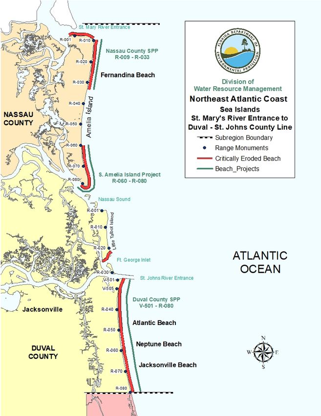
Florida Department of Environmental Protection, Strategic Beach Management Plan – Northeast Atlantic Coast Region

       Environmental Protection .................................................................................................................. 24
       Sand Sources ..................................................................................................................................... 25
       Additional Information ...................................................................................................................... 25
References ................................................................................................................................................ 28
Flagler-Volusia Beaches ......................................................................................................................... 31
   Strategies for Inlets and Critically Eroded Beaches ........................................................................ 31
       Area Wide Studies ............................................................................................................................. 31
       Painters Hill, Flagler County, R50-R57 ............................................................................................ 32
       Northern Flagler Beach, Flagler County, R65.2-R72........................................................................ 32
       Flagler Beach, Flagler County, R76-R94.8 ....................................................................................... 32
       Southern Flagler Beach, Flagler County, R98-R100/south county line ............................................ 33
       Northern Volusia and Ormond-By-The-Sea, Volusia County, R24-R33.......................................... 33
       Ormond Beach to Wilbur-by-the-Sea, Volusia County, R57–R118 ................................................. 33
       Ponce de Leon Inlet, Volusia County, R148-R149 ........................................................................... 34
       New Smyrna Beach and Bethune Beach, Volusia County, R160.8 – R207.8 .................................. 35
   Regional Strategies for Beach and Inlet Management .................................................................... 35
       Sponsors and Funding ....................................................................................................................... 35
       Project Coordination.......................................................................................................................... 36
       Environmental Protection .................................................................................................................. 36
       Sand Sources ..................................................................................................................................... 37
       Additional Information ...................................................................................................................... 37
References ................................................................................................................................................ 39
Appendix - Acronyms ................................................................................................................................ i

April 2020, Page ii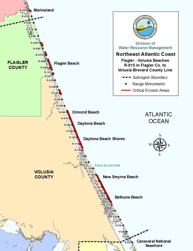
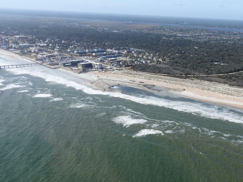
Florida Department of Environmental Protection, Strategic Beach Management Plan – Northeast Atlantic Coast Region

   St. Augustine Shore Protection Project at early stages of construction near R141 in February 2018, photo by W.G. Weeks.

April 2020, Page iii
Florida Department of Environmental Protection, Strategic Beach Management Plan – Northeast Atlantic Coast Region

 Introduction - Northeast

 The Northeast Atlantic Coast Region has a total of 135.7 miles of beaches of which, 62.2 miles are
 critically eroded and 21.6 miles are actively managed. There are also seven inlets within the Northeast
 Atlantic Region, where three of those inlets have an inlet management plan. For additional beach
 management or project information, see the current Critically Eroded Beaches Report, the joint
 coastal permits by county, or the local government funding requests by county.

 Each subregion listed below will have the introductory paragraph listing miles of coastline and
 erosional events/ storms that have affected the subregion. Each title within the subregion will list the
 coastal location, the county and the range (R) survey markers for the critical erosion area. For inlets,
 river entrances, or passes the title, the county, and the adjacent range survey markers will be stated. In
 addition, there will be a subregion map highlighting the critical erosion areas and the managed project
 areas. Finally, references to coastal reports will also be listed at the end of each subregion.

 For more specific information concerning projects or strategies along Florida’s coastline, see
 the following links for the other six coastal regions of Florida. For background information,
 see the Strategic Beach Management Plan’s Introduction.

     Strategic Beach Management Plan’s Introduction
     Central Atlantic Coast Region
     Southeast Atlantic Coast Region
     Florida Keys Region
     Southwest Gulf Coast Region
     Big Bend Gulf Coast Region
     Panhandle Gulf Coast Region

 For additional information pertaining to beach and ocean conditions, coastal associations, educational
 institutions, or government agencies, see the following related coastal sites.

 The State of Florida was significantly impacted by three hurricanes, Hermine, Matthew and Irma
 during the 2016 and 2017 hurricane seasons. To see additional information for strategies and funding
 to address recovery for the beaches and dunes, see the “Hurricane Damage Assessment Report for
 2016: Florida’s Beaches and Dunes”. For the 2017 Hurricane season, see the “Hurricane Irma Post-
 Storm Beach Conditions and Coastal Impact in Florida” report. The post-storm survey data has been

April 2020, Page 1 of 40
Florida Department of Environmental Protection, Strategic Beach Management Plan – Northeast Atlantic Coast Region fully analyzed and an updated list of critically eroded beaches is in the Critically Eroded Beaches Report. Sea Islands There are 27.7 miles of beaches in the Sea Islands subregion, which extends from the south end of Cumberland Island, Georgia, to the Duval–St. Johns County line, as shown in Figure 1. There is a total of 18.1 miles of critically eroded beaches in this subregion (7.7 miles in Nassau County and 10.4 miles in Duval County), of which 17.8 miles have been restored and are maintained. Erosion is attributed to frequent northeasters, occasional hurricanes, and the effects of the St. Mary’s River Entrance, the St. Johns River Entrance, Nassau Sound, and Ft. George Inlet. The most erosive storms have been the Thanksgiving northeaster of 1984, a series of northeasters in November and December in 1992, Hurricane Floyd (1999), Tropical Storm Gabrielle (2001), Hurricane Frances (2004), Hurricane Ophelia (2005), Tropical Storm Tammy (2005), Subtropical Storm Andrea (2007), October northeasters (2007), Tropical Storm Noel (2007), Tropical Storm Beryl (2012), Hurricane Matthew (2016) and Hurricane Irma (2017). Other events with severe impacts include the Ash Wednesday northeaster of March 1962, Hurricane Dora (1964), and the February 1973 northeaster. Strategies for Inlets and Critically Eroded Beaches St. Marys River Entrance, Nassau County The St. Marys River Entrance is part of the federally authorized Fernandina Harbor Navigation Project, and is the entrance to the Port of Fernandina and Kings Bay Naval Base in St. Marys, Georgia. Maintenance dredging generally occurs on an annual basis with beach quality sand placed on the inlet shoreline at Fort Clinch State Park, on the ocean shoreline of Fernandina Beach, or in a nearshore disposal area. Dredged material containing excessive fines, but which is otherwise beach compatible, is placed in a nearshore disposal area. The U.S. Navy and the State of Florida executed a Memorandum of Understanding in 1986 that states all beach compatible material dredged from the St. Marys River is to be placed on downdrift beaches or in nearshore areas of Amelia Island. The Florida Department of Environmental Protection (Department or DEP) adopted the St. Marys River Entrance Inlet Management Study Implementation Plan in May 1998, which established an annual bypassing objective of between 554,000 and 779,000 cubic yards (cy). April 2020, Page 2 of 40
Florida Department of Environmental Protection, Strategic Beach Management Plan – Northeast Atlantic Coast Region

 Sand tightening of the south jetty was completed in 1988 in conjunction with deepening the federal
 navigation channel. The improvements to the groin field at Fort Clinch as recommended in the plan
 were completed in April 2000. In 2004, a feasibility study was performed to investigate removal of
 the interior north jetty shoal of Cumberland Island. Several legal issues need to be resolved before this
 study’s recommendations can be given further consideration. Updating the sediment budget and inlet
 management plan are needed for this project area when analyzing monitoring data from the last 16
 years. From 2008 until April 2015, the U.S. Army Corps of Engineers (USACE) has bypassed
 sediment to the North Beach (R13-R16) of Fernandina, and placed approximately 465,200 cy of
 beach compatible material to the benefit of the Nassau County Shore Protection Project. This has
 allowed the maintenance of the restoration project to exceed its predicted five-year nourishment
 interval. The USACE report entitled, “Northeast Florida Regional Sediment Management,” dated
 March 2016, studied this subregion and the St. Marys River Entrance. The report outlines additional
 opportunities that would enhance the regional sediment management (RSM) program in Northeast
 Florida, and it has been shown that additional investigation is needed to maximize the potential beach
 quality sand for use on adjacent eroding beaches.

 Strategy: Update the sediment budget and adopt an updated inlet management plan; continue to
 bypass beach compatible sediment to the downdrift beaches to mitigate the effects of the inlet; place
 non- compatible dredge material in the nearshore.

 Fort Clinch, Nassau County, 2,500 feet west of R1-R9

 This is a 2.5-mile segment of critically eroded inlet shoreline of Amelia Island fronting the St. Marys
 River Entrance. Located within this shoreline is the historic Fort Clinch and Fort Clinch State Park.
 Sand placement from maintenance dredging occurred in the groin field and at the south jetty in 2007,
 2009, 2010, 2012, 2015, 2017, 2018 and 2019.

 Strategy: Maintain the groin field that protects Fort Clinch; continue strategic sand placement from
 the navigation project or other sources.

April 2020, Page 3 of 40
Florida Department of Environmental Protection, Strategic Beach Management Plan – Northeast Atlantic Coast Region

 Fernandina Beach, Nassau County, R9-R33

This is a 4.4-mile segment of critically eroded beach extending from the south jetty of the St. Marys
river entrance to Sadler Road in Fernandina Beach. The Nassau County Shore Protection Project
was federally authorized in 1972 in response to Hurricane Dora (1964). Federal emergency funds were
appropriated in 1965 to place granite stone revetments along 2.8 miles of shoreline between R12 to
R27. Sand dredged from the St. Marys River Entrance Channel has been placed in this segment since
1978, see the project history in Table 1. The initial beach restoration was completed in 2008, using
approximately 1,932,000 cy of sand from an offshore borrow site that was placed within the municipal
boundary of Fernandina Beach (R13-R34.5). The City of Fernandina Beach is the local government
sponsor for the project. The project design consists of a beach berm at elevation +10 ft NAVD that is
intended to protect the existing dune and upland development. The nourishment interval was five
years, but the project has exceeded design expectations, due to few storm impacts and the periodic
bypassing of material from the St. Marys River Entrance Channel in 2011, 2013, 2014, 2015, 2016,
2017, 2018 and 2019. A total of 1,605,592 cy has been placed along North Beach between R13-R16
and in 2016, 2018 and 2019 between R25-R27. As a result of the bypassing, the federal shore
protection project is performing well, and the first nourishment is to be determined. The federal project
is authorized until 2058.

Table 1. Nassau County Shore Protection Project beach placement that includes bypassing from St.
Marys Entrance Channel, since 2011.

                                                                          Project Location
     Date Completed             Volume (cy)             Source           (by R monument)          Length (mi)
                                                        St. Marys
            1978                  1,000,000             Entrance               R12-R22                  1.9
                                                        Channel
                                                        St. Marys
            1982                   360,000              Entrance               R19-R25                  1.1
                                                        Channel
                                                        St. Marys
         1987-1988                 907,000              Entrance               R13-R22                  1.7
                                                        Channel
                                                        St. Marys
        1992-2007*               1,988,284*             Entrance                                        1.7
                                                                               R13-R22
       (nine events)                                    Channel
     September 2008               1,932,000             Offshore              R13-R34.5                 3.8
                                                        St. Marys
            2011                    89,988              Entrance               R13-R16                  0.6
                                                         Channel

April 2020, Page 4 of 40
Florida Department of Environmental Protection, Strategic Beach Management Plan – Northeast Atlantic Coast Region
Project Location
Date Completed Volume (cy) Source (by R monument) Length (mi)
St. Marys
2013 130,000 Entrance R13-R16 0.6
Channel
St. Marys
March 2014 107,634 Entrance R13-R16 0.6
Channel
St. Marys
April 2015 400,704 Entrance R13-R16 0.6
Channel
St. Marys
March 2016 302,695 Entrance R20-R27 1.3
Channel
St. Marys
March 2017 164,303 Entrance R13-R15.5 0.5
Channel
St. Marys
March 2018 70,268 Entrance R25-R27 0.4
Channel
St. Marys
2019 358,936 Entrance R24-R34 1.9
Channel
*Nine separate events - divided volume # by nine = 220,920 cy per bypassing event.
Strategy: Maintain the project through monitoring and periodic nourishment using sand from
offshore and from inlet maintenance.
South Amelia Island, Nassau County, R60-R80
This is a 3.3-mile segment of critically eroded beach along the southern portion of Amelia Island,
including the South Amelia Island Shoreline Stabilization Association (SAISSA) and the Amelia
Island State Park. The alternating northern and southern migration of Nassau Sound has resulted in
alternate periods of accretion and erosion at the ends of Amelia and Little Talbot Islands. The non-
federal South Amelia Island Beach Nourishment Project (R60-R80) was initially constructed in 1994
using sand obtained from an offshore borrow area. The project design consists of a beach berm at
elevation +10 ft NAVD. The project was designed for nourishment at eight-year intervals. Dredging
of the Atlantic Intracoastal Waterway (AIWW) through Nassau Sound is scheduled for every three to
five years, with placement of beach quality sand between R73 and R79. The project history for this
segment of shoreline is described in Table 2. To stabilize the south end of the island, a terminal rock
groin and offshore breakwater were constructed in 2004. Due to the importance of emergent shoals in
Nassau Sound for migrating and resident bird populations, the terminal rock groin was designed to be
April 2020, Page 5 of 40Florida Department of Environmental Protection, Strategic Beach Management Plan – Northeast Atlantic Coast Region
“leaky” to allow for the continued movement of sand across the Sound to feed the emergent shoals.
The south end of the project within the boundaries of the state park (R76-R79) was nourished in 2006
with 400,000 cy of sand dredged from the Sawpit Creek Cut section of the AIWW. The maintenance
of the Intracoastal Waterway at Sawpit Creek Cut continues to contribute sand to nourish the beaches
along the South Amelia Island project. A full nourishment (R59.5-R77) followed in 2011, using
2,100,000 cy of material from an offshore source. Most recently, 580,000 cy of beach disposal
material from the AIWW was placed in 2013 along the park shorefront from R75 to R77.5. SAISSA
supported a reconnaissance-level field investigation that collected vibracores in offshore federal
waters to identify potential sand sources in 2016. The AIWW beach disposal from Sawpit Creek
occurred in April 2019 with placement of approximately 576,868 cy of sand between R75 and R77.5.
The next nourishment event is scheduled for 2021.
Table 2. South Amelia Island Beach Nourishment project history.
Date
Completed Volume (cy) Sand Source Project Location Length (mi.)
August 1994 2,600,000 offshore R60-R78 3.2
September Sawpit Creek Cut -
1997 300,000 AIWW R73.5-R78 0.85
Sawpit Creek Cut -
2001 300,000 AIWW R73.5-R78 0.85
September
2002 1,900,000 offshore R60-R79.5 3.4
Sawpit Creek Cut -
2006 400,000 IWW R76-R79 0.4
2011 2,100,000 offshore R59.5-R77 3.2
Sawpit Creek Cut -
2013 580,000 AIWW R75-R77.5 0.5
Sawpit Creek Cut -
April 2019 576,868 AIWW R75-R77.5 0.5
Strategy: Maintain the project through monitoring and nourishment using sand from offshore;
placement of beach compatible sand from maintenance dredging of the AIWW.
Nassau Sound, Nassau County R79 to Duval County R1
This is an undeveloped, highly variable inlet with migrating emergent shoals. A draft inlet
management plan was formulated in 1993 by stakeholders but was never adopted by the Department.
April 2020, Page 6 of 40Florida Department of Environmental Protection, Strategic Beach Management Plan – Northeast Atlantic Coast Region Little Talbot Island State Park, Duval County, R21-R23 This is a 0.3-mile segment of critically eroded beach on the southern end of Little Talbot Island, fronting the Atlantic Ocean (R21-R23), and a 0.7-mile segment of critically eroded shoreline fronting Fort George Inlet (R23 – A1A bridge). The inlet shoreline and part of the Atlantic shoreline has a rock revetment to protect the bridge abutment. In 1999, a federal shore protection project consisting of a revetment to protect the shoreline and bridge abutment on Little Talbot Island was authorized, but the federal project was not constructed. Park facilities have been relocated due to erosion from the inlet migration and storm damage. The USACE in early 2019, along with the South Amelia Island and Shore Stabilization Association (SAISSA) have initiated the process for a Section 111 feasibility study to address erosion problems near the inlet and Little Talbot Island. Strategy: Continue to perform physical monitoring and vertically controlled aerial photography. Fort George Inlet, Duval County, R25-R26 Fort George Inlet is a natural inlet that has not been altered or maintained for navigation but has been strongly affected by navigation improvements at the St. Johns River Entrance since the 1800s. The shoal north of the northern St. John’s River Entrance jetty has grown and is currently used as a City of Jacksonville Huguenot Memorial public park. The inlet channel has migrated north and is eroding Little Talbot Island State Park. The Department’s Division of Recreation and Parks sponsored a study of the inlet in 1999, which recommended relocation of the inlet channel to its historic southern location and the closure of the existing inlet by the hydraulic placement of the sand derived from new channel construction. The study did not investigate the alternative of bypassing sand to the downdrift shoreline south of the St. Johns River Entrance or bypassing to the eroded northernmost segment of Talbot Island. The inlet was studied again in 2011 by the Beaches and Shores Resources Center. The USACE report entitled, “Northeast Florida Regional Sediment Management,” dated March 2016, studied this subregion and the Ft. George Inlet. The report outlines additional opportunities that would enhance the regional sediment management (RSM) program in Northeast Florida and it has been shown that additional investigation is needed to maximize the potential beach quality sand for use on adjacent eroding beaches. In early 2019, the USACE, along with the South Amelia Island and Shore Stabilization Association (SAISSA) initiated a Section 111 feasibility study to address erosion problems near the inlet and Little Talbot Island. April 2020, Page 7 of 40
Florida Department of Environmental Protection, Strategic Beach Management Plan – Northeast Atlantic Coast Region

Strategy: Monitor; coordinate with the USACE - RSM work to implement strategies for inlet
management.

St. Johns River Entrance, Duval County, R30-V501

The St. Johns River Entrance is part of the federally authorized Jacksonville Harbor Navigation
Project and is the entrance to the Port of Jacksonville and Mayport Naval Station. The maintenance
dredging of the entrance channel generally occurs on a semi-annual basis, with the placement of beach
compatible sand on the downdrift shoreline south of the river entrance and continues to contribute
sand to nourish the beaches along the Duval County Shore Protection Project. More than 1 million cy
of material is dredged annually from the remaining 26 miles of the navigation channel and placed in
upland disposal sites or in an Offshore Dredged Material Disposal Site. The USACE completed the
Jacksonville Harbor Channel Deepening Study, and the report was signed by the Chief of Engineers in
April 2014. The current depth of the channel is approximately -40 feet, and the study looked at
deepening the channel to a maximum depth of -50 feet. A Joint Coastal Permit for the Jacksonville
Harbor Federal Channel Expansion project has been reviewed and issued by the Department to
authorize the deepening of the federal navigation channel to a depth of -47 feet or -49 feet, depending
on the river section, with an allowable 2-foot overdepth dredging from mean lower low water
(MLLW). The Department issued the permit for the channel expansion in July 2016. Dredging began
in February 2018 for the deepening of the federal navigation channel.

 The USACE completed the “Northeast Florida Regional Sediment Management” report dated March
 2016, which studied this subregion and the St. Johns River to enhance the USACE-RSM program.
 The study showed that additional investigation is needed to maximize the potential beach quality sand
 for potential use on adjacent beaches.

 Strategy: Continue to bypass suitable sediment from maintenance dredging to the downdrift beaches;
 adopt an inlet management plan of the St. Johns River Entrance - Fort George Inlet complex; continue
 to coordinate with the USACE - RSM work.

 St. Johns River to the Duval - St. Johns County Line, Duval County, V501-R80

 This is a 10.1-mile segment of critically eroded beach from the southern jetty of the St. Johns River
 entrance southward to the Duval–St. Johns County line, and the project history for this segment of
 shoreline is described in Table 3. The federally authorized Duval County Shore Protection Project
 (South Jetty-R31-R80) was initiated in 1977 and completed in 1980, using sand from maintenance

April 2020, Page 8 of 40
Florida Department of Environmental Protection, Strategic Beach Management Plan – Northeast Atlantic Coast Region

 dredging of the river entrance and from an offshore borrow area. Nourishments occurred in 1985,
 1986, 1987, 1991, and 1995. In 2003, nourishment began using sand dredged from the river entrance.
 This work stopped after placement of about 120,000 cy, when it was determined the material
 contained excessive amounts of shell and clay and it was therefore deemed unsuitable for placement
 on the beach. The project was reinitiated and completed in 2005 using material from an offshore
 borrow area. Work included repair of 8,500 feet of dunes located between R43 and R80. In the 2011
 nourishment, 689,015 cy of material was placed along Duval County’s Atlantic shoreline. The project
 design consists of a beach berm at elevation +8 ft NAVD to protect the existing dune and upland
 development. The project is authorized until 2028. The next nourishment was planned for the fall of
 2016 to place approximately 682,000 cy of material along most of Atlantic Beach, all of Neptune
 Beach, and all of Jacksonville Beach. There were construction delays due to Hurricane Matthew, and
 additional post-storm work was completed in May 2017 with placement of approximately 222,088 cy.
 An additional 192,851 cy of material was used for dune restoration. Due to Hurricane Irma, the next
 beach nourishment construction event was constructed in the winter of 2018/2019. The USACE beach
 nourishment event placed approximately 777,847 cy for the beach berm and 90,156 cy for the dune
 from an offshore borrow area.

Table 3. Duval County Shore Protection Project history.

                                 Volume                                   Project Location
    Date Completed                                      Source           (by R monument)           Length (mi)
                                  (cy)
                                                  Offshore borrow
     September 1978             1,267,800                area                R34.5-R52.7                3.3
                                                  Offshore borrow
       October 1980             1,609,200                area                R52.7-R80                  5.0
                                                   St. Johns River
       October 1980              822,800          Entrance Channel           S. Jetty-R33               1.5
                                                   St. Johns River
            1985                1,284,400         Entrance Channel            R39-R53.7                 2.8

                                                  Offshore borrow
            1986                 308,650               area                   R52.7-R67                 2.4

                                                  Offshore borrow
            1987                 849,770                area                 R60 to R80                 3.8
                                                  Offshore borrow
            1991                 300,000                 area                R44-R52.7                  1.6
                                                  Offshore borrow
     November 1995              1,187,279                                      R47-R80                  7.0
                                                         area
                                                   St. Johns River
            2003                 120,000          Entrance Channel             R72-R80                  1.5

April 2020, Page 9 of 40
Florida Department of Environmental Protection, Strategic Beach Management Plan – Northeast Atlantic Coast Region
Volume Project Location
Date Completed Source (by R monument) Length (mi)
(cy)
Offshore borrow R43-R53 and
August 2005 615,198 area R57- R80 6.0
Offshore borrow R43.5–R53 and
August 2011 689,015 area R57- R80 5.9
Offshore borrow
December 2016 682,000 R52-R80 5.3
area
Offshore borrow
May 2017 192,851* R45-R72.5 5.2
area
Offshore borrow
May 2017 222,088 area R45-R80 6.6
Offshore borrow
January 2019 777,847 area R33.5-R80 9.6
Offshore borrow R39-R53 and
January 2019 90,156* area 3.9
R72.5-R80
* Dune Only
Strategy: Maintain the project through monitoring, nourishment and sand bypassing.
Regional Strategies for Beach and Inlet Management
Sponsors and Funding
This subregion contains the governmental entities of Nassau County; the City of Fernandina Beach;
Duval County; and the Cities of Jacksonville, Atlantic Beach, Neptune Beach, and Jacksonville
Beach; the Port of Jacksonville; and the Florida Inland Navigation District (FIND). There are two
major military installations in this area, Kings Bay Naval Base (Georgia) and Mayport Naval Station,
which share navigation facilities with civilian resources and are maintained by the USACE
Jacksonville District (SAJ). There are significant public park lands in this area, including the north
and south ends of Amelia Island, Big Talbot Island and Little Talbot Island, administered by the
Department’s Division of Recreation and Parks, and Huguenot and Hanna Park administered by the
City of Jacksonville.
Participants with the Department as sponsors of beach management projects include the City of
Fernandina Beach, Duval County, the City of Jacksonville, the Department’s Division of Recreation
and Parks, the South Amelia Island Shoreline Stabilization Association (SAISSA), the FIND, and the
USACE. Project cost estimates and schedules may be found in Beach Management Funding
Assistance Program - Long Range Budget Plan.
April 2020, Page 10 of 40Florida Department of Environmental Protection, Strategic Beach Management Plan – Northeast Atlantic Coast Region
Project Coordination
Regionalization is the funding and coordination of multiple erosion control projects and inlet
management activities to take advantage of identifiable cost savings through economies of scale,
reduced equipment mobilization and demobilization costs, and elimination of duplicative
administrative tasks. Opportunities in this subregion include:
1. The Department and the USACE have completed a regional sediment management
demonstration project in the Sea Islands and St. Johns Beaches subregions. Tasks included
designation of government liaisons to coordinate beach management activities, development
of methods and techniques for exchange and dissemination of planning and project
information, coordination of USACE input, review and comment on the Strategic Beach
Management Plan and Long-Range Budget Plan, and monthly updates on USACE activities
pertinent to statewide sediment management opportunities and issues. The USACE is
currently pursuing ways to implement this project’s recommendations.
2. The maintenance of the navigation project at St. Johns River Entrance should be
coordinated with beach nourishment of the beach erosion control project for Duval County
if material is determined to be beach compatible.
3. The maintenance of the Intracoastal Waterway at Sawpit Creek Cut is coordinated with
beach nourishment of the South Amelia Island project.
Environmental Protection
The protection of marine turtles, right whales, beach mice, shorebirds, and their habitats are primary
environmental concerns within this subregion. Sensitive areas for shorebirds include Ft. Clinch, south
Amelia Island, Sawpit and the Talbot Islands and Huguenot Park. Additionally, emergent shoals
within the Nassau Sound are utilized by resident and migrating birds and must be maintained or
restored. These areas are subject to change as conditions change, and coordination with FWC
shorebird staff is encouraged during project development. The timing of construction activities has not
been restricted during the marine turtle nesting season of May 1 through October 31, but activities
must be monitored. Project design and method of construction may be restricted to avoid or minimize
adverse impacts to the listed species and their habitat. Fort Clinch on Amelia Island is a significant
historical resource where material from maintenance dredging has been placed and shore protection
April 2020, Page 11 of 40Florida Department of Environmental Protection, Strategic Beach Management Plan – Northeast Atlantic Coast Region
structures have been constructed. The Nassau River - St. Johns River Marshes and Fort Clinch
Aquatic Preserves are located within the Sea Islands Subregion, and encompass critically eroded
beaches. Projects located within and near the Aquatic Preserve boundaries require additional
protection, including meeting more stringent anti-degradation water quality standards.
Sand Sources
Sufficient sand sources for beach nourishment over the next 15 years have been identified for all
projects. A regional sediment management (RSM) strategy that uses beach quality sand from upland
dredged material management areas and the maintenance dredging of navigation projects should be
incorporated into the maintenance of the projects. The Department has outlined various RSM
strategies in its inlet management plans and strategic beach management plans. The USACE,
Jacksonville District (SAJ) RSM work effort through the South Atlantic Division’s Center of
Expertise (CX) aids the Department in updating these plans. The USACE-SAJ published an RSM
technical report in FY 2015, by their Engineer and Research Development Center (ERDC), to better
jointly manage navigation, coastal storm damage reduction and ecosystem restoration projects. It is
the goal of the Department to coordinate with the USACE-SAJ and implement strategies mutually
beneficial to the USACE and the Department’s missions by leveraging federal authorities, permits,
and funding. For additional information on sand sources, the Department manages a database named
the Regional Offshore Sand Source Inventory (ROSSI).
Additional Information
The introduction of the State’s Strategic Beach Management Plan provides additional background
information on the Department’s Beach Management Programs and includes overviews of:
• The principles and statutes followed to help guide the State’s management strategies
• Comprehensive list of Florida’s inlets
• The miles of critically eroded beaches under active management
• Statewide sand source studies
• Statewide monitoring programs
• Innovative technologies examined
• Basic suggestions for emergency response plan
April 2020, Page 12 of 40Florida Department of Environmental Protection, Strategic Beach Management Plan – Northeast Atlantic Coast Region Figure 1. Map of the Sea Islands subregion of the North Atlantic Region of Florida. View an interactive map or COASTS imagery. April 2020, Page 13 of 40
Florida Department of Environmental Protection, Strategic Beach Management Plan – Northeast Atlantic Coast Region

 References

 Balsillie, J. H., 1985. Post-Storm Report: The Florida East Coast Thanksgiving Holiday Storm of 21-
         24 November 1984, Florida Department of Natural Resources, Division of Beaches and
         Shores, Post-Storm Report No. 85-1, 74 p.

 Clark, R.R., LaGrone, J.W., Brantly, R.., 2004. Hurricane Frances & Hurricane Jeanne: Post-Storm
         Beach Conditions and Coastal Impact Report with Recommendations for Recovery and
         Modifications of Beach Management Strategies, Florida Department of Environmental
         Protection, Bureau of Beaches and Coastal Systems, 93 p.

 Clark, R.R., 2000. The Impact of Hurricanes Floyd and Irene on the Florida East Coast, Florida
         Department of Environmental Protection, Bureau of Beaches and Coastal Systems, Report
         No. BCS-00-01, 55 p.

 Clark, R.R., Steele, J.K., Weeks, W.G., Brantly, R.F., and Manausa, M., 2017. Hurricane Damage
         Assessment Report for 2016: Florida’s Beaches and Dunes, Florida Department of
         Environmental Protection, Engineering, Hydrology and Geology Program, 55 p.

 Clark, R.R., Wang, R., Weeks, W.G., Bacopoulos, P., Manausa, M., 2018. Hurricane Irma: Post-
         storm Beach Conditions and Coastal Impact in Florida, Florida Department of
         Environmental Protection, Engineering, Hydrology and Geology Program, 107 p.

 Florida Department of Environmental Protection. 2004 Hurricane Recovery Plan for Florida’s Beach
         and Dune System, 65 p.

 Florida Department of Environmental Protection, 2019. Critically Eroded Beaches in Florida,
         Division of Water Resource Management, 89 p.

 Florida Department of Environmental Protection, 1998. St. Mary’s River Entrance Inlet Management
         Study Implementation Plan, May 1998, 12 p.

 Florida State University’s Beaches and Shores Resource Center, 2011. Inlet Management Plan and
         Sediment Budget for St. Johns River Entrance / Ft George Inlet, Florida, St. Johns County,
         Florida

April 2020, Page 14 of 40
Florida Department of Environmental Protection, Strategic Beach Management Plan – Northeast Atlantic Coast Region
Foster, E.R., Spurgeon, D.L., and Cheng, J., 2000. Shoreline Change Rate Estimates, Duval
County, Florida Department of Environmental Protection, Bureau of Beaches and Coastal
Systems, Report No. BCS-00-01, 56 p.
Foster, E.R., Spurgeon, D.L., and Cheng, J., 1999. Shoreline Change Rate Estimates, Nassau
County, Florida Department of Environmental Protection, Bureau of Beaches and Coastal
Systems, Report No. BCS-99-04, 54 p.
Kraus, N.C., Gorman, L.T., Pope, J., 1993. Kings Bay Coastal and Estuarine Physical Monitoring and
Evaluation Program: Coastal Studies, U.S. Army Corps of Engineers, Waterways Experiment
Station, Technical Report CERC-93-xx, 286 p.
Olsen Associates, Inc., 1997. St. Marys River Entrance Inlet Management Plan
Olsen Associates, Inc., 2004. Cumberland Shoals Dredging Feasibility Study
Olsen Assoicates, Inc., 2011. Nassau County Shore Protection Project, Year 3-Monitoring Report
Olsen Associates, Inc., 2013. Nassau County Shore Protection Project, Fernandina Beach,
Florida, Year 5 Monitoring Report, November 2013, 41 p. plus appendices.
Olsen Associates, Inc., 2004. South Amelia Island Shore Stabilization Project, Phase I - Beach
Restoration, Year 1 Monitoring Report
Olsen Assoicates, Inc., 2011. South Amelia Island Shore Stabilization Project, Post-Construction
Report
Olsen Associates, Inc., 1994. Nassau Sound Inlet Management Plan
Olsen Assoicates, Inc., 2011. Duval County Shore Protection Project, Project Completion Report
Olsen Associates, Inc., 1997. Amelia Island, Florida, SAISSA Beach Restoration Project,
Monitoring Report No. 3, December 1997
Olsen Associates, Inc., 2000. Amelia Island, Florida, SAISSA Terminal Groin Field, Monitoring
Report No. 5, October 2000
April 2020, Page 15 of 40Florida Department of Environmental Protection, Strategic Beach Management Plan – Northeast Atlantic Coast Region
Olsen Associates, Inc., 2016. Amelia Island, Nassau County Florida, Marine Geological Field
Investigation for Offshore Geologic Model Support & BOEM Notice of Scientific
Research NA15-001, May 2016
Olsen Associates, Inc., 1999. Fort George Inlet Shoreline Erosion Plan
Olsen Associates, Inc., 2019. Nassau County Shore Protection Project, Post-2019 Beach
Renourishment Monitoring Report, 34 p., plus appendices.
United States Department of the Navy and the State of Florida., 1986. Memorandum of Understanding
Concerning Dredging of the St. Marys Inlet Channel
U.S. Army Corps of Engineers, 1999. Duval County, Florida, November 1995 Beach
Renourishment Monitoring Report #3, December 1999
U.S. Army Corps of Engineers, 1998. Duval County, Florida, November 1995 Beach
Renourishment Monitoring Report #1, March 1998
U.S. Army Corps of Engineers, 1998. Nassau County, FL Shore Protection Project: General
Reevaluation Report with Draft Environmental Assessment
U.S. Army Corps of Engineers, 1998. Water Resources Development in Florida
U.S. Army Corps of Engineers, 1984. Feasibility Report with Environmental Impact Study for
Beach Erosion Control - Nassau County, Florida (Amelia Island)
U.S. Army Corps of Engineers, 1964. Beach Erosion Control Study on Duval County, Florida
U.S. Army Corps of Engineers, 2010. Duval County, Florida, August 2005 Beach
Renourishment Monitoring Report #5, October 2010
U.S. Army Corps of Engineers, 2014. Jacksonville Harbor Navigation Study – Final Integrated
General Reevaluation Report II and Supplemental Environmental Impact Statement, April
2014, 289 p.
U.S. Army Corps of Engineers, 2016. Northeast Florida Regional Sediment Management;
Implementation Strategies and Recommendations for Nassau County and Duval County,
Florida, March 2016, 68 p.
April 2020, Page 16 of 40Florida Department of Environmental Protection, Strategic Beach Management Plan – Northeast Atlantic Coast Region St. Johns Beaches There are 43.7 miles of beaches in the St. Johns Beaches subregion, which extends from the Duval– St. Johns County line to just south of Marineland in Flagler County (R15), as shown on Figure 2 There are 16.9 miles of critically eroded beaches in this subregion (16.3 miles in St. Johns County and 0.6 mile in northern Flagler County), of which 3.8 miles have been restored and maintained. Erosion is attributed to frequent winter northeasters, occasional tropical storms and hurricanes, and the effects of St. Augustine Inlet and Matanzas Inlet. The most erosive storms in recent years were a February 1973 northeaster, the Thanksgiving Day northeaster of 1984, Hurricane Floyd (1999), Hurricane Irene (1999), Tropical Storm Gabrielle (2001), Hurricanes Frances and Jeanne (2004), Hurricane Ophelia and Tropical Storm Tammy (2005), Subtropical Storm Andrea (2007), October northeaster (2007), Tropical Storm Noel (2007), Tropical Storm Fay (2008), Hurricane Matthew (2016), Hurricane Irma (2017), and Hurricane Dorian (2019). Other events with severe impacts include the Ash Wednesday northeaster of March 1962 and Hurricane Dora (1964), which made landfall at St. Augustine. Strategies for Inlets and Critically Eroded Beaches Ponte Vedra, St. Johns County, R26-R31 This is a 0.9-mile segment of critically eroded beach in the Ponte Vedra area. This area was impacted by Hurricane Matthew (2016) and Hurricane Irma (2017), leaving residential development vulnerable to future high frequency storm erosion. The USACE is seeking funds to conduct a Coastal Storm Risk Management feasibility study for the North Ponte Vedra area between R1 to R46. A local homeowners’ group is considering design and permitting tasks for construction of a beach or dune restoration project. Strategy: Conduct feasibility study and physical monitoring; perform post-storm dune restoration. South Ponte Vedra Beach and Vilano Beach, St. Johns County, R76–R117.5 This is an 8.2-mile segment of critically eroded beach located north of St. Augustine Inlet and within the area of inlet influence. A federal feasibility study was initiated in 2005 to evaluate erosion control alternatives, but funding availability delayed completion of the study for many years. Design alternatives were considered for dune restoration in 2008 at the local level, but the project was never constructed. April 2020, Page 17 of 40
Florida Department of Environmental Protection, Strategic Beach Management Plan – Northeast Atlantic Coast Region

 Hurricane Sandy (2012) and northeasters accelerated erosion in this area. An additional 0.7-segment of
 critical erosion was added to the critically eroded list for South Ponte Vedra in 2014. Another 2.2 miles
 was added to the critically eroded list between South Ponte Vedra and Vilano Beach in 2015. Hurricane
 Matthew caused severe damage and erosion throughout this segment in October 2016, resulting in
 another 1.6 miles of critical erosion being added to the north end of South Ponte Vedra in 2017.
 Funding was secured in 2015 to continue the federal feasibility study. This area is eligible for receiving
 inlet dredge material in accordance with the updated St. Augustine Inlet Management Plan (2014).
 Dredged material from St. Augustine Inlet in the amount of 165,226 cy was placed in the designated
 nearshore disposal area of Vilano Beach in the summer of 2015. An additional amount of dredged
 material from the Intracoastal Waterway (123,344 cy) and St. Augustine Inlet (13,937 cy) was placed
 on Vilano Beach between R113 to R117, totaling of 137,281 cy, and work was completed in April
 2017. Additional major damage and erosion was caused by Hurricane Irma in September 2017.

 In response to Hurricane Matthew (2016), the County is pursuing a dune restoration project between
 R76 and R101.5. Emergency funds for constructing the dune restoration project have been secured.
 Design and permitting the dune restoration project has taken additional time due to securing a BOEM
 permit for use of an offshore borrow site in federal waters. The dune restoration project is expected to
 place approximately 573,000 cy of sand (20 cy per ft. on average) and is to be constructed in
 2020/2021.

 The USACE released the feasibility study and environmental assessment for the South Ponte Vedra
 Beach, Vilano Beach and Summer Haven Reaches in February of 2016. The selected plan for this
 coastal storm risk feasibility study is located north of St. Augustine Inlet of three miles of shoreline
 between R102.5 and R117.5 at Vilano Beach and a small portion of southern South Ponte Vedra.
 The initial beach and dune restoration is expected to place approximately 1.3 million cy of beach
 compatible sand with a 60-ft seaward berm extension and maintenance of the existing dune. In
 addition, there would be an additional placement of 866,000 cy of beach compatible sand in four
 periodic nourishment events at 12-year intervals. The initial restoration is currently being designed
 with an anticipated construction date of summer of 2020.

 Strategy: Design and construct the selected plan from the USACE feasibility study for the South Ponte
 Vedra/ Vilano Beach segment; monitor; conduct dune restoration; conduct inlet sediment bypassing
 consistent with the updated St. Augustine Inlet Management Plan (2014).

April 2020, Page 18 of 40
Florida Department of Environmental Protection, Strategic Beach Management Plan – Northeast Atlantic Coast Region

 St. Augustine Inlet, St. Johns County, R122-R123

 St. Augustine Inlet was created by dredging a new inlet in 1940 north of the historic St. Augustine
 Inlet, located near the current location of Salt Run. The north jetty was constructed in 1941 and a
 south jetty was completed in 1957. The inlet is part of the federal St. Augustine Harbor Navigation
 Project. Maintenance dredging of the inlet channel follows the best natural alignment across the inlet
 bar that exists at the time. Between 1940 and 1986, 1,373,000 cy of material were dredged from the
 inlet. Maintenance dredging occurred frequently during the 1970s, but the channel was only dredged
 in 1986 and 1996 due to reductions in the authorized channel depth and changes in shoaling patterns.
 Dredged material was typically disposed of offshore, until the 1996 dredging event placed 170,000 cy
 of sand on the beaches both north and south of the revetment at St. Augustine Beach. The St.
 Augustine Inlet Management Study Implementation Plan was approved for adoption in 1998. Periodic
 maintenance dredging of the Intracoastal Waterway near St. Augustine Inlet and the Salt Run
 navigation channel was initiated in 1999, with beach placement of dredged material at Anastasia State
 Park and St. Augustine Beach. The federally authorized St. Johns County Shore Protection Project
 (R137-R150) used sand from the St. Augustine Inlet ebb shoal as the sand source in 2003 and 2005.
 The project dredged sand from Vilano Point, the St. Augustine inlet channel and the inlet ebb shoal to
 nourish the beach again in 2012. The St. Augustine Inlet Management Implementation Plan was
 updated in 2014. The USACE dredged the inlet navigation channel in 2018 and the south lobe of the
 ebb shoal to provide sand for the nourishment of the St. Johns County Shore Protection Project.

 Strategy: Bypass sediment to the adjacent beaches to meet an average annual placement objective of
 278,000 cy; conduct study of the inlet structures for possible improvements to facilitate sediment
 bypassing; implement the state’s updated Inlet Management Plan (2014), which includes balancing
 the sediment budget by placing one-third of inlet sediment to the north beaches of the inlet and two-
 thirds of the inlet sediment to the south beaches of the inlet; continue to coordinate with the USACE
 in developing and implementing the RSM study.

 Anastasia State Park and St. Augustine Beach, St. Johns County, R123-R128 and R132–R152

 This is a combined 4.8-mile segment of critically eroded beach located south of St. Augustine Inlet
 and within the area of influence of the inlet. This segment includes a one-mile portion at the northern
 end of Anastasia State Park (R123-R128) and then a 3.8-mile segment of Anastasia State Park and
 the City of St. Augustine Beach (R132-R152). In 1973, a spur groin was built at Anastasia State Park,
 and a coquina revetment was built along the south end of St. Augustine Beach. In 1988, an additional

April 2020, Page 19 of 40
Florida Department of Environmental Protection, Strategic Beach Management Plan – Northeast Atlantic Coast Region

 spur groin was built at the northern end of the historic seawall. Since 1996, maintenance dredging of
 the St. Augustine Inlet has placed sand on the beaches within this area.

 Initially authorized in 1986, the federal St. Johns County Shore Protection Project (R137-R151) was
 reauthorized in 1999 to add mitigation of the effects of the navigation project as a new project
 purpose. The project history of nourishment for this segment of shoreline is described in Table 4.
 Initial restoration was completed in January 2003, with sand excavated from the St. Augustine Inlet
 ebb shoal. The project included the local option extension of the restoration project 4,600 feet north
 into Anastasia State Park to R132. Following Hurricanes Frances and Jeanne in 2004, which caused
 severe erosion in this area, the nourishment schedule was accelerated, and construction of a
 nourishment project was completed in September of 2005 using sand excavated from the St.
 Augustine Inlet ebb shoal. Construction occurred again in August 2012 for the St. Johns County
 Shore Protection Project, with sand excavated from Vilano Point, the St. Augustine inlet channel, and
 the inlet ebb shoal. The project design consists of a beach berm at elevation +9 ft NAVD to protect
 the existing dune and upland development. The project is authorized until 2051. Nourishment was
 completed again in June 2018 and placed approximately 747,185 cy of sand along St. Augustine
 Beach between R139.7 and R144.4.

Table 4. St. Johns County Shore Protection Project history.

        Date                Volume (cy)          Sand Source        Project Location        Length (mi.)
      Completed

     January 2003            4,200,000           Inlet channel        R132 to R151               3.7
                                                 and ebb shoal

       September             2,800,000            Inlet channel       R137 to R151               2.7
         2005                                    and ebb shoal
                                                 Vilano Point,
     August 2012             2,199,340           inlet channel        R139 to R147               1.5
                                                 and ebb shoal

       June 2018              747,185            Inlet channel      R139.7 to R144.4             0.9
                                                 and ebb shoal

 Strategy: Maintain the project through monitoring and nourishment; consider alternative sand
 sources for the project that include a sand search investigation on the relic shoal off Anastasia Island
 between the active ebb shoal and the county pier; continue to coordinate with the USACE in
 developing and implementing the RSM study.

April 2020, Page 20 of 40
Florida Department of Environmental Protection, Strategic Beach Management Plan – Northeast Atlantic Coast Region Matanzas Inlet, St. John’s County, R196-R197 Matanzas Inlet is a natural inlet that is strongly affected by a bridge abutment and revetment on the south shoreline, the dredging of the Intracoastal Waterway and stabilization of Rattlesnake Island. The Intracoastal Waterway, separated from the inlet by Rattlesnake Island, is dredged about every three years, and the sand is placed at Summer Haven, south of the inlet. Strategy: Develop a sediment budget and adopt an inlet management plan. Summer Haven, St. Johns County, R197-R209 This is a 2.4-mile segment of critically eroded beach in unincorporated Summer Haven, and is within the area of influence of Matanzas Inlet. Sand from the Intracoastal Waterway dredging is placed by FIND on the Summer Haven beaches when available. Dredging has resulted in beach placement of dredge material during the following events, and the project history for this segment of shoreline is described in Table 5. The 1992 event placed 191,502 cy; 1999 event placed 222,000 cy; 2004 event placed 214,475 cy; and 2007 event placed 187,862 cy. In 2002 and 2003, sand was truck-hauled from upland sites to construct small emergency protective berms and partially restore sand lost during Tropical Storm Gabrielle and Hurricane Floyd, using funds from FEMA. A federal reconnaissance study has been completed, and a federal feasibility study was initiated in 2005 for Summer Haven. Barrier island overwash has historically been a problem in Summer Haven, but in 2008 Tropical Storm Fay produced an overwash and a breach at R200. From 2009 to 2010, the breach allowed the Matanzas River to be filled with beach sand in the vicinity of Summer Haven, inhibiting the flow of the river from just east of the A1A bridge to approximately R203. The St. Augustine Port, Waterway, and Beach District was issued a permit by the Department in February 2014 to excavate approximately 216,000 cy of sand from the Matanzas River, with placement on the adjacent beach and dune between R200 and R208, which restored flow to the river. Summer Haven had 1,280 cy of material from the Intracoastal Waterway placed on the beach in 2015. The USACE released the draft feasibility study and environmental assessment for the South Ponte Vedra Beach, Vilano Beach and Summer Haven Reaches in February of 2016. The selected plan did not include any of the Summer Haven Reaches for several reasons: a non-federal sponsor was not identified; limited public access; previous relocation of State Road A1A; minimal number of structures in southern portion; limited road access and damage susceptibility; county purchases of properties when able; the cost-benefit- ratio would not justify a 50- year federal project; and limited alternatives due to the Coastal Barrier April 2020, Page 21 of 40
You can also read