ARCHITECTURAL HERITAGE IMPACT ASSESSMENT
←
→
Page content transcription
If your browser does not render page correctly, please read the page content below
PROPOSED BLOCK A AND ASSOCIATED AMENDMENTS- PARKGATE STREET                                        FOR RUIRSIDE DEVELOPMENTS LTD

12          ARCHITECTURAL HERITAGE IMPACT ASSESSMENT

12.1        Introduction
            This chapter describes the likely significant effects on architectural heritage arising from the existence
            of a proposed residential landmark building on former industrial lands at 42A Parkgate Street, Dublin.
            These lands were formerly occupied by the Hickey Home Focus fabric company.
            No works to any protected structures or other historic structures of heritage value on the 42A Parkgate
            Street site are proposed as part of the current application and so the existence of the proposed
            residential landmark building will not give rise to any direct effects on the architectural heritage of these
            structures. Permission was granted by An Bord Pleanála in May 2020 for works to protected and historic
            structures on the 42A Parkgate Street site, including the demolition of some structures, ABP reference
            306569-20. The current application does not propose any changes to what was approved under that
            permission.
            This Chapter has been prepared by W.H. Hastings of ARC Architectural Consultants Ltd. Bill is an
            architect, Fellow of the Royal Institute of the Architects of Ireland and RIAI Grade 1 accredited
            Conservation Architect, with fifty years’ experience working in architecture and architectural services.
            He has particular experience in conservation, measured survey and recording, digital modelling &
            photomontage and environmental impact assessment.
            Please refer to Chapter 1 for further details on his relevant qualifications and experience.

12.2        Assessment methodology
12.2.1 General
            A desktop study of the Dublin City Development Plan 2016-2022 and of the Record of Protected
            Structures, as set out therein, and the National Inventory of Architectural Heritage was carried out to
            identify structures and places of architectural heritage value in the vicinity of the proposed
            development and policies relating to the protection of Dublin’s historic environment. ARC carried out
            considerable research of relevant books, historic documents and historic mapping as part of this
            assessment. In addition, a series of site visits was carried out to determine the likely impact of the
            proposed development on architectural heritage. This assessment was prepared with reference to the
            Department of Arts, Heritage and the Gaeltacht’s Architectural Heritage Protection Guidelines for
            Planning Authorities

12.2.2 Impact Assessment Methodology
            Section 51(1) of the Planning and Development Act 2000 (as amended) states:
            For the purpose of protecting structures, or parts of structures, which form part of the architectural
            heritage and which are of special architectural, historical, archaeological, artistic, cultural, scientific,
            social or technical interest, every development plan shall include a record of protected structures, and
            shall include in that record every structure which is, in the opinion of the planning authority, of such
            interest within its functional area.
            Therefore, the Act defines architectural heritage as connected to architectural, historical,
            archaeological, artistic, cultural, scientific, social or technical interest. It is for each Planning Authority
            to decide if a structure is of sufficient special interest with regard to any or all of these eight indicators
            to warrant that structure being entered in the Record of Protected Structures. Structures that are not
            Protected Structures may still be of heritage value because they are considered as having some level of
            interest under one or more of the eight indicators. It follows, therefore, that the extent of impact or
            effect on the architectural heritage of a structure will be measured by extent to which its heritage
            interest is altered or removed. The effect can be positive if the heritage interest is enhanced or negative
            if the heritage interest is diminished.

STEPHEN LITTLE & ASSOCIATES                                                                                            JUNE 2021
                                                              12.1
PROPOSED BLOCK A AND ASSOCIATED AMENDMENTS- PARKGATE STREET                                      FOR RUIRSIDE DEVELOPMENTS LTD

            The assessment effects on Architectural Heritage had regard to the Guidelines on the Information to be
            Contained in Environmental Impact Assessment Reports prepared by the Environmental Protection
            Agency (Draft of 2017), and to Directive 2011/92/EU (as amended by Directive 2014/52/EU) on the
            assessment of the likely effects of certain public and private projects on the environment.
            The list of definitions given below is taken from Table 3.3: Descriptions of Effects contained in the
            Guidelines on the Information to be Contained in Environmental Impact Assessment Reports prepared
            by the Environmental Protection Agency. Some comment is also given below on what these definitions
            might imply in the case of architectural heritage. The definitions from the EPA document are in italics.
            •      Imperceptible: An effect capable of measurement but without significant consequences. The
                   definition implies that there would be minor change to an aspect of the heritage interest of a
                   structure, but not one that would be readily noticeable to the casual observer; and not a change
                   that would materially alter the overall heritage interest of the structure or its surroundings.
            •      Not Significant: An effect which causes noticeable2 changes in the character of the environment
                   but without significant consequences (the footnote ‘2’ to the word ‘noticeable’ is: ‘for the purposes
                   of planning consent procedures’). The definition implies that there would be changes to aspects
                   of the heritage interest of a structure capable of being noticed by an observer who is actively
                   assessing the effects of changes to the heritage interest of a structure for the purposes of planning
                   consent, and, although there may be changes to aspects of the heritage interest of a structure,
                   these changes would not be considered material with reference to planning consent.
            •      Slight: An effect which causes noticeable changes in the character of the environment without
                   affecting its sensitivities. The definition implies that there would be changes to aspects of the
                   heritage interest of a structure or part of that structure. However, apart from such changes, the
                   overall heritage interest of the structure, and/or its contribution to its surroundings, would remain
                   substantially intact.
            •      Moderate: An effect that alters the character of the environment in a manner that is consistent
                   with existing and emerging baseline trends. In this case, there would be material changes to the
                   heritage interest of a structure or part of that structure. These changes must be consistent with a
                   pattern of change that is already occurring, is considered acceptable, and is envisaged by policy.
            •      Significant: An effect which, by its character, magnitude, duration or intensity alters a sensitive
                   aspect of the environment. The definition implies that there would be material changes to aspects
                   the heritage interest of a structure or part of that structure and that these changes would not be
                   consistent with an acceptable pattern of change that is already occurring, nor are envisaged by
                   policy.
            •      Very Significant: An effect which, by its character, magnitude, duration or intensity significantly
                   alters most of a sensitive aspect of the environment. The definition implies that the heritage
                   interest of a structure would be changed to a considerable degree and these changes would not
                   be consistent with an acceptable pattern of change that is already occurring or envisaged by
                   policy. For example, a “very significant” effect would occur where the heritage interest of a
                   structure or structures would be substantially removed as a result of a proposed development,
                   though parts of the structure might remain intact.
            •      Profound: An effect which obliterates sensitive characteristics. The definition implies that a
                   development would result in the loss of the heritage structure, or all of its heritage significance.
            The above Descriptions of Effects relate to effects on Architectural Heritage. This assessment relates
            solely to effects on Architectural Heritage, and does not concern itself with other effects, beneficial or
            adverse.
            The extent of effects on the architectural heritage of the surrounding area resulting from the complete
            loss of a structure of heritage interest will depend on the importance of the structure. The removal of
            a heritage structure might result in a whole range of potentially significant beneficial effects in terms
            of planning gain and sustainable development; but these are not of themselves positive effects on
            architectural heritage and are not evaluated as part of the assessment of effects on architectural
            heritage.

STEPHEN LITTLE & ASSOCIATES                                                                                          JUNE 2021
                                                              12.2
PROPOSED BLOCK A AND ASSOCIATED AMENDMENTS- PARKGATE STREET                                       FOR RUIRSIDE DEVELOPMENTS LTD

            It is noted that there are a number of scenarios in which substantial alteration to heritage structures is
            supported by heritage policy. Giving a heritage building a new and sustainable use would be one such
            situation. In such circumstances the degree of intervention in the heritage structure must be only the
            minimum necessary to provide for the new use. Unnecessary interventions would have to be assessed
            as resulting in negative effects on architectural heritage.

12.2.3 Study Area
            The assessment of the potential for effects on architectural heritage arising from the existence of the
            development examined the River Liffey Corridor from Dublin Port to west of Island Bridge, the Phoenix
            Park and the lands of the Royal Hospital Kilmainham, and areas of Dublin City north, east and south of
            the subject site up to a distance of 1 kilometre from the site.

12.2.4 Consultation
            Since the summer of 2018, there has been continuous consultation between ARC, the design team and
            the planning consultants in relation to the architectural heritage significance of structures on the
            application site and the potential effects of development on those structures. This process informed
            both the assessment of effects on architectural heritage, if any, and design of the proposed
            development.
            As part of the Strategic Housing Development process material has been provided to An Bord Pleanála
            and there was a meeting with the Board, attended by the development team and the Planning Authority
            on the 15th of April 2021. ARC also attended this meeting. Subsequent to the meeting the Board issued
            a Pre-Application Consultation Opinion, and ARC’s assessment has had regard to this opinion.

12.3        Statutory Provisions
            Chapter 11: Built Heritage and Culture of the Dublin City Development Plan 2016-2022 sets out the
            Planning Authority’s policies with regard to architectural heritage. Policy CHC1 provides that it is a policy
            of the Planning Authority “to seek the preservation of the built heritage of the city that makes a positive
            contribution to the character, appearance and quality of local streetscapes and the sustainable
            development of the city.”
            Policy CHC4 provides:
              “It is the policy of Dublin City Council to protect the special interest and character of all Dublin’s
              Conservation Areas. Development within or affecting a conservation area must contribute positively
              to its character and distinctiveness, and take opportunities to protect and enhance the character and
              appearance of the area and its setting, wherever possible.
              Enhancement opportunities may include:
              1. Replacement or improvement of any building, feature or element which detracts from the
                 character of the area or its setting
              2. Re-instatement of missing architectural detail or other important features
              3. Improvement of open spaces and the wider public realm, and re-instatement of historic routes
                 and characteristic plot patterns
              4. Contemporary architecture of exceptional design quality, which is in harmony with the
                 Conservation Area
              5. The repair and retention of shop- and pub-fronts of architectural interest.
              Development will not:
              1.      Harm buildings, spaces, original street patterns or other features which contribute positively to
                      the special interest of the Conservation Area

STEPHEN LITTLE & ASSOCIATES                                                                                           JUNE 2021
                                                              12.3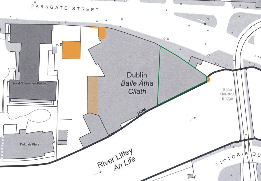
PROPOSED BLOCK A AND ASSOCIATED AMENDMENTS- PARKGATE STREET                                            FOR RUIRSIDE DEVELOPMENTS LTD

              2.      Involve the loss of traditional, historic or important building forms, features, and detailing
                      including roof-scapes, shop-fronts, doors, windows and other decorative detail
              3.      Introduce design details and materials, such as uPVC, aluminium and inappropriately designed
                      or dimensioned timber windows and doors
              4.      Harm the setting of a Conservation Area
              5.      Constitute a visually obtrusive or dominant form.
              Changes of use will be acceptable where, in compliance with the zoning objective, they make a positive
              contribution to the character, function and appearance of Conservation Areas and their settings. The
              Council will consider the contribution of existing uses to the special interest of an area when assessing
              change of use applications and will promote compatible uses which ensure future long-term viability.”
              The Development Plan acknowledges, under Section 11.1.5.8, that there may be circumstances under
              which the demolition of a protected structure must take place as follows: “The City Council accepts
              that in some circumstances the loss of a heritage structure (protected structure or non-protected
              structure of merit) may be the only option and this may be permitted where it will secure substantial
              public benefit or where there is no other viable option. Decisions on the acceptability of demolition will
              be reached having regard to the significance of the structure and the guidance as set out in the
              Guidelines for Planning Authorities on Architectural Heritage Protection published by the Department
              of Arts, Heritage, Regional, Rural and Gaeltacht Affairs (2011).”
              The Architectural Heritage Protection Guidelines for Planning Authorities (2011) set out
              comprehensive advice in relation to conservation and the management of the historic built
              environment. However, the Guidelines clearly advocate a balanced approach. For example, while the
              Guidelines state “historic structures are a unique resource. Once lost, they cannot be replaced. If their
              special qualities are degraded, these can rarely be recaptured.” (Section 7.2.1), the Guidelines also
              clarify that “entry into the Record of Protected Structures does not mean that a structure is forever
              frozen in time. Good conservation practice allows a structure to evolve and adapt to meet changing
              needs while retaining its particular significance.” (Section 7.2.2).
            The Guidelines advocate strongly for ensuring that heritage buildings are kept in active use as a
            mechanism for ensuring conservation of buildings of architectural heritage value, as set out at Section
            7.3:
              “It is generally recognised that the best method of conserving a historic building is to keep it in active
              use. Where a structure is of great rarity or quality, every effort should be made to find a solution which
              will allow it to be adapted to a new use without unacceptable damage to its character and special
              interest. Usually the original use for which a structure was built will be the most appropriate, and to
              maintain that use will involve the least disruption to its character. While a degree of compromise will
              be required in adapting a protected structure to meet the requirements of modern living, it is
              important that the special interest of the structure is not unnecessarily affected. Where a change of
              use is approved, every effort should be made to minimise change to, and loss of, significant fabric and
              the special interest of the structure should not be compromised.”
            Section 7.7 is relevant to the subject application as it promotes minimum intervention with buildings of
            architectural heritage value:
              “7.7.2          In granting planning permission, a planning authority should be satisfied that works are
                              necessary, whether these be repair works to the fabric of the building or adaptations to the
                              structure to allow it to perform a new or enhanced function. Over-restoration of historic
                              buildings can be detrimental to their character and value. Old buildings both charm and
                              inform for the very reason that they are old. Bulging or leaning walls, unevenness and bowing
                              are not necessarily imperfections to be ironed out but are evidence of the building’s antiquity.
                              Such evidence of a patina of age is irreplaceable and should be preserved where possible with
                              appropriate professional advice.
              7.8.2           In order to appreciate the integrity of a structure, it is important to respect the contribution
                              of different stages of its historical development. Concentration on whether or not various
                              parts of a building are ‘original’ can obscure the fact that later alterations and additions may

STEPHEN LITTLE & ASSOCIATES                                                                                                JUNE 2021
                                                                  12.4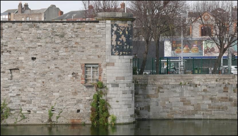
PROPOSED BLOCK A AND ASSOCIATED AMENDMENTS- PARKGATE STREET                                            FOR RUIRSIDE DEVELOPMENTS LTD

                              also contribute to the special interest of the structure. Of course there may be alterations or
                              additions which have not contributed to the special interest of the building, and which may
                              in fact have damaged it.
              7.9.2           Many historic structures date from a time when the majority of building materials were
                              wrought by hand. These materials have a variety and vitality that cannot be matched by
                              machine-made materials. Tooling and chisel marks on stonework, undulations in blown-glass
                              panes, and adze marks on timber elements supply a wealth of irreplaceable information
                              about the people and the times that produced these structures. Also, through time, a
                              structure and its components acquire a patina of age that cannot be replicated. The
                              unnecessary replacement of historic fabric, no matter how carefully the work is carried out,
                              will have an adverse effect on the character of a building or monument, seriously diminish its
                              authenticity and will significantly reduce its value as a source of historical information.
                              Replacing original or earlier elements of a building with modern replicas only serves to falsify
                              the historical evidence of the building.”
            Section 8.3 relates to the repointing of stonework
              “8.3.15 Repointing has the potential to cause physical damage to the fabric of the building, radically
                      alter its appearance and substantially detract from its character and quality. A proposal to
                      repoint stonework of a protected structure, which would materially alter its character,
                      requires planning permission; and, where permitted, the work should be carried out by
                      experienced people and under the direction of a specialist with a working knowledge and
                      experience of historic buildings.
              8.3.16 Repointing should be considered a repair which replaces lost or damaged fabric with that of a
                       compatible and appropriate mix (or series of mixes), material and appearance, providing
                       always that the existing pointing is not inappropriate or damaging to the stonework.
                       Comprehensive repointing of a structure is rarely necessary, unless the existing pointing has
                       deteriorated and is causing damage to the stonework or other fabric. It should be a condition
                       that sound old pointing is left undisturbed as it is an essential part of the fabric and character
                       of a historic building or structure and should not be removed unnecessarily.”
              and Section 13.1 regarding determining the curtilage of a protected structure:
              “13.1.1 By definition, a protected structure includes the land lying within the curtilage of the
                      protected structure and other structures within that curtilage and their interiors. The notion
                      of curtilage is not defined by legislation, but for the purposes of these guidelines it can be
                      taken to be the parcel of land immediately associated with that structure and which is (or
                      was) in use for the purposes of the structure. It should be noted that the meaning of ‘curtilage’
                      is influenced by other legal considerations besides protection of the architectural heritage
                      and may be revised in accordance with emerging case law…
              13.1.3          It should be noted that the definition of curtilage does not work in reverse – a stable building
                              may be within the curtilage of the main house which it was built to serve but the main house
                              cannot be described as being within the curtilage of the stable building. It should also be
                              noted where a protected structure is an element of a structure, it may, or may not, have a
                              curtilage depending on the degree to which is could in its own right be considered to be a
                              structure. For example, a re-used doorway affixed to a later structure could not be said to
                              have a curtilage.”

STEPHEN LITTLE & ASSOCIATES                                                                                                JUNE 2021
                                                                  12.5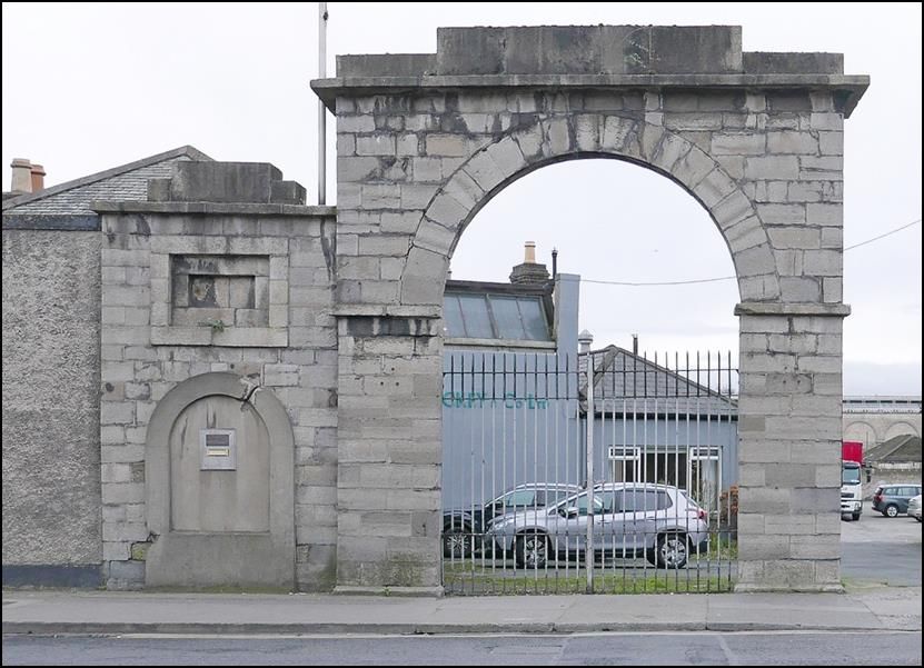
PROPOSED BLOCK A AND ASSOCIATED AMENDMENTS- PARKGATE STREET                                      FOR RUIRSIDE DEVELOPMENTS LTD

12.4        Receiving Environment
            In categorising the baseline environment, ARC sought first to identify structures and features of known
            architectural heritage merit with reference to the Dublin City Council Record of Protected Structures
            and to the National Inventory of Architectural Heritage. ARC carried out a desktop review of relevant
            sources on the development of the area and conducted comparative assessment of relevant historic
            mapping and present day Ordnance Survey mapping in order to identify whether any other structures
            of architectural heritage value (i.e. structures not listed as protected structures or referenced in the
            NIAH) may be located on the site or in the vicinity of the application.
            The site of the proposed development is the relatively small eastern tip of a larger development site
            that was until recently occupied by the Hickeys fabric company. The address of this larger site is 42A
            Parkgate Street, and an extensive Strategic Housing Development was granted permission on the larger
            western portion of this site in the summer of 2020, ABP Reference 306569-20. The overall site at 42A
            Parkgate Street lies at the eastern end of an historic strip of land along the north bank of the River Liffey
            sloping down from Conyngham Road and Parkgate Street and the River, and running west from
            Parkgate street all the way to Chapelizod. This strip of land is referred to on Rocque’s Map of 1773 and
            on other maps of the late 18th and early 19th centuries, as the Long Meadows. The first buildings on
            the Long Meadows appear to have been the buildings of the Phoenix Ironworks, founded by Richard
            Robinson in 1808. The Hickeys site occupies the eastern half of the lands of the former ironworks. The
            entry for Richard Robinson in the Dictionary of Irish Architects is as follows:
            Engineer and ironfounder of the Phoenix Iron Works, Parkgate Street. Richard Robinson, a native of Hull,
            settled in Dublin in 1800. His Phoenix foundry was responsible for casting King’s Bridge, designed by
            GEORGE PAPWORTH to commemorate the visit of George IV to Dublin in 1823. The foundry acquired
            the designation ‘Royal’ in this year. Robinson died in 1848 and is buried in St Michan’s Church of Ireland
            church. By 1844 he had been succeeded in the business by William Robinson who carried on until 1858
            or later. By 1863 the foundry had been taken over by Edward Toomey.
            Edward Toomey ran the Royal Phoenix Ironworks until his death in the late 1870s.
            The entry in Thoms Directory for the Royal Phoenix Ironworks for 1880 shows that it was vacant at that
            date. There was a long advertisement for the sale of the Ironworks in the Freemans Journal of the 24th
            of January 1880, part of which is as follows:
            CITY OF DUBLIN.TRUSTEES’ SALE OF EXTENSIVE PREMISES, PLANT, STOCK. &c. IMPORTANT TO IRON
            FOUNDERS, ENGINEERS, DISTILLERS,
            C. JAMES CONNOLLY and SON have been instructed by the Trustees of the late Edward Toomey.
            TO DISPOSE OF BY PUBLIC AUCTION, On the Premises, on WEDNESDAY, 4th February, 1880, Their
            Interest in all that and those the extensive concerns known as the Royal Phoenix Iron Works, adjoining
            the King’s-bridge at Parkgate-street, and close to the terminus of the Great Southern and Western
            Railway, together with the superior Dwellinghouse, Out- offices, Pleasure Grounds, Gardens, &c., the
            entire containing 3a 6r 38p statute measure, with a handsome entrance from Parkgate-street, the river
            Anna Liffey being its boundary in the south. There are also eight two-storied Cottages for workmen, with
            foundry workshops, forge, &c. where a considerable trade was successfully carried on for many years;
            there being also a great facility of water carriage up and down the river Liffey for the export and import
            of heavy articles connected with the trade.
            This advertisement, together with the evidence of early Ordnance maps indicates what structures were
            on the overall Hichey’s site prior to 1880. The First Edition Ordnance map of 1837, though at the small
            scale of 6 inches to the mile indicates that the house near the north west corner of the present site was
            there in 1837, as was the gateway from Parkgate Street. The larger scale 1847 Ordnance map tends to
            confirm this. The round turret at the eastern point of the site is shown on both maps. A second turret,
            some distance west of the present site and now gone, is also shown. The building directly abutting the
            river is shown as much smaller than the Hickey’s warehouse building, otherwise buildings of the Royal
            Phoenix Ironworks are set back from the river. The present high stone wall to the river can only in part
            date from the time of the Royal Phoenix Ironworks, and the pattern of the stonework on the present
            wall shows that it has been altered many times.

STEPHEN LITTLE & ASSOCIATES                                                                                          JUNE 2021
                                                              12.6
PROPOSED BLOCK A AND ASSOCIATED AMENDMENTS- PARKGATE STREET                                      FOR RUIRSIDE DEVELOPMENTS LTD

            The entry on Thoms Directory for 1882 is: Royal Phoenix Ironworks., with a rateable valuation of £10
            and on a second line: The Kingsbridge Woollen Works. This is the last mention of the Phoenix Ironworks.
            In Thoms Directory the name of the business operating at the address continues to be The Kingsbridge
            Woollen Works until 1888. From 1885 to 1888 the name is: Guinness, Edward C, Cloth Manufacturer. In
            1885 he is plain Guinness, Edward C, in 1888 Guinness, Sir Edward C, Bart.
            In Thoms Directory the valuation for the Royal Phoenix Ironworks falls from £130 in 1870 and 1880 to
            just £10 in 1882. By 1886, under the direction of Edward C. Guinness, the valuation had risen to £405.
            The evidence from Thom’s Directory, taken together with the evidence of Ordnance mapping and other
            historical evidence, strongly indicates that the main Hickey’s warehouse on the site and the two gabled
            buildings to the south west of it were built between 1882 and 1886 under the direction of Edward C.
            Guinness for the Kingsbridge Woollen Works.
            Evidence from Ordnance mapping indicates that most of the buildings and structures that formed part
            of the Royal Phoenix Ironworks were demolished and replaced between 1864 and 1889. On the 1889
            Ordnance map the layout of the buildings on the Hickeys site is shown to be largely similar to the
            present layout. The disposition of the buildings of the Royal Phoenix Ironworks was quite different. On
            the 1889 map the extensive new eastern building is shown with a northlight roof.
            Edward Cecil Guinness, later to become the 1st Earl of Iveagh, had been the sole owner of the Guinness
            Brewery since 1876. In 1881 he bought the premises of the Royal Phoenix Ironworks and established
            the Kingsbridge Woollen Works in order to provide employment for young girls, which was scarce in
            Dublin at the time. He spent some £50,000 on constructing the new works, an enormous sum at the
            time. The Kingsbridge Woollen Works employed around 150 women; but the experiment failed, with
            the Woollen Works losing between £3,000 and £4,000 per year.
            For the year 1889, the entry in Thoms Directory is as follows:
            The Kingsbridge Mills, Clayton F. & J. and Co (Limited), Woollen Worsted Manufacturers, and Navan,
            £405 Kingsbridge House, Fred Clayton M.D. M.A. F.S.A. Ph.D. Woollen Manufacturer.
            The firm of F & J Clayton and Co, owned by Frederick and John Clayton was established in Navan in
            1837. In 1867 they took over a large mill at Millbrook on the river Blackwater just outside Navan. The
            Clayton family had been running mills at Horton in Yorkshire for the previous 200 years. Clayton’s
            Woollen Mills at Navan was a very large concern. It continued in business until the 1960s.
            Claytons only operated the woollen mills at Parkgate Street for a relatively short period. Thoms
            Directory for 1900 refers to the premises as the Phoenix Park Works, operated by Charles McDonnell
            and Son, Manufacturers. In 1910 and 1916 the Phoenix Park Works are listed as being vacant. In 1917,
            the premises are listed as the Dublin National Shell Factory, a munitions factory, and continue to have
            that listing until 1920. In 1921 and 1922 the premises is listed as Government Stores. In 1924 the
            premises is listed as Cahill and Co. Ltd: Printers, Etc. Cahill Printers remained at Parkgate Street till the
            1970s, when the premises was taken over by Hickeys.

STEPHEN LITTLE & ASSOCIATES                                                                                          JUNE 2021
                                                              12.7
PROPOSED BLOCK A AND ASSOCIATED AMENDMENTS- PARKGATE STREET FOR RUIRSIDE DEVELOPMENTS LTD
Figure 12.1: Extract from the current Ordnance map, indicating, in orange, structures on the overall 42A
Parkgate Street site that appear on the 1837 First Edition Ordnance map. Most of the other structures date
from the mid 1880s. The green line indicates the approximate boundary of site of the proposed residential
landmark building.
Extracts from Thoms Directory for the Subject Site
1861 Phoenix Ironworks, Wm Robinson, Engineer and Ironfounder
1870 Royal Phoenix Ironworks, Edward Toomey, Millwright, Engineer and Iron
Founder. £130
1880 Royal Phoenix Ironworks. Vacant. £130
1881 Royal Phoenix Ironworks. Mrs Toomey. £130
1882 Royal Phoenix Ironworks. £10 The Kingsbridge Woollen Works
1883 The Kingsbridge Woollen Works
1884 The Kingsbridge Woollen Works
1885 Guinness, Edward C, Cloth Manufacturer The Kingsbridge Woollen Works
1886 Guinness, Edward C, Bart, Cloth Manufacturer The Kingsbridge Woollen Works
£405
1887 Guinness, Edward C, Bart, Cloth Manufacturer The Kingsbridge Woollen Works
£405
STEPHEN LITTLE & ASSOCIATES JUNE 2021
12.8PROPOSED BLOCK A AND ASSOCIATED AMENDMENTS- PARKGATE STREET FOR RUIRSIDE DEVELOPMENTS LTD
Extracts from Thoms Directory for the Subject Site
1888 Guinness, Sir Edward C, Bart, Cloth Manufacturer The Kingsbridge Woollen
Works £405 (Premises Closed)
1889 The Kingsbridge Mills, Clayton F. & J. and Co (Limited), Woollen Worsted
Manufacturers, and Navan £405 Kingsbridge House, Fred Clayton M.D. M.A.
F.S.A. Ph.D. Woollen Manufacturer
1890 The Kingsbridge Mills, Clayton F. & J. and Co (Limited), Woollen Worsted
Manufacturers, and Navan Kingsbridge House, Fred Clayton M.D. M.A. F.S.A.
Ph.D. Woollen Manufacturer
1900 Phoenix Park Works, McDonnell, Charles and Son, Manufacturers Kingsbridge
House, Cussen, Mr E, £225 £40
1910 Phoenix Park Works. Vacant. £225 £40 1916 Phoenix Park Works. Vacant. £225
£40
1917 Dublin National Shell Factory. Directors: Kelly, Capt. R. C; Downie, Capt. F; Grey,
Lewis C., C.A.; Sec: Shaw, Crawford. £366
1920 Dublin National Shell Factory; Inspector of Stores and Clothing, Receiving Depot
and Pattern Room.
1921 Government Stores, Inspector of Stores and Clothing, Receiving Depot and
Pattern Room.
1922 Government Stores, Inspector of Stores and Clothing, Receiving Depot and
Pattern Room.
1923 No Listing
1924 Cahill and Co. Ltd: Printers, Etc
1925 Cahill and Co. Ltd: Printers, Etc £490
1930 43. Cahill and Co. Ltd: Printers, Etc £545
1941 43. Cahill and Co. Ltd: Printers, Etc £545 46. Kiosk £4’10’0
1950 43. Cahill and Co. Ltd: Printers, Etc £545 46. Kiosk £4’10’0
1960 43. Cahill and Co. Ltd: Printers, Bookbinders, Publishers. £525 Parkside Press
Ltd: Publishers
1971 43. Cahill and Co. Ltd: Letterpress and Lithographic Printers and Bookbinders.
£525 Parkside Press Ltd: Publishers, Mellifont Press Ltd: Publishers
1980 43. Hickey and Co. Ltd : Fabrics. £525
STEPHEN LITTLE & ASSOCIATES JUNE 2021
12.9PROPOSED BLOCK A AND ASSOCIATED AMENDMENTS- PARKGATE STREET FOR RUIRSIDE DEVELOPMENTS LTD
Figure 12.2: Extract from John Rocques map of Dublin of 1773. Conyngham Road and Parkgate Street are not
named. The ‘Long Meadows’ are shown on the north side of the River Liffey. Kingsbridge is not yet there. The
Viceregal Stream is shown running into the Liffey at the east end of the Long Meadows. Where the Stream
meets the River is the immediately west of the location of the Turret at the east end of the 42A Parkgate Street
site.
Figure 12.3: Extract from Duncan’s Map of Dublin of 1821.The map indicates a triangle of buildings and two
other small buildings on the 42A Parkgate Street site. At that date the surrounding area of the city and all the
lands to the south and west are dominated by military buildings and institutions. The Wellington Testimonial,
construction of which would only have just started, is shown in the centre of a group of military buildings: The
Magazine Fort, The Royal Infirmary, The Royal Barracks, The Royal Hospital and The Artillery Barracks.
STEPHEN LITTLE & ASSOCIATES JUNE 2021
12.10PROPOSED BLOCK A AND ASSOCIATED AMENDMENTS- PARKGATE STREET FOR RUIRSIDE DEVELOPMENTS LTD
Figure 12.4: Enlargement of part of the First Edition Ordnance map of 1837, showing the original extent of the
Phoenix Iron Works, which was approximately twice the area of the 42A Parkgate St site. The map shows round
turrets at the eastern and western end of the river frontage.
Figure 12.5: Extract from the Ordnance map of 1847. Kingsbridge station is shown on the south side of the
river, though marked as ‘unfinished’. The production buildings of the now Royal Phoenix Ironworks would
appear all to have been at the east end of the site, and the western end is shown laid out as gardens. Only the
most easterly building on the site abuts the River. The rest are set back. There appears to be a slipway from the
centre yard of the works down to the River. Where walls are shown on the map, these were probably of the
nature of garden walls, and unlikely to have been more than 2 metres in height.
STEPHEN LITTLE & ASSOCIATES JUNE 2021
12.11PROPOSED BLOCK A AND ASSOCIATED AMENDMENTS- PARKGATE STREET FOR RUIRSIDE DEVELOPMENTS LTD
Figure 12.6: Extract from the Ordnance map of 1864.The layout of the Royal Phoenix Ironworks is little changed
from the 1847 map. This map provides more detail of the layout of the extensive gardens. ‘Kingsbridge’ House
is clearly defined and is shown with buildings on Parkgate Street north of the house, separated from the house
by a small yard on the north east.
Figure 12.7: Extract from the Ordnance map of 1889.The layout of buildings on the east and south of the site
has been completely changed. The present warehouse with its northlight roof is clearly defined on the map.
The range of buildings near the River at the south west of the has been largely removed, and trees are shown
at the River’s edge. From an auction advertisement in 1880, we know that the buildings to the north west along
Parkgate Street are workers cottages. The entire is now titled ‘Kingsbridge Woollen Factory.
STEPHEN LITTLE & ASSOCIATES JUNE 2021
12.12PROPOSED BLOCK A AND ASSOCIATED AMENDMENTS- PARKGATE STREET FOR RUIRSIDE DEVELOPMENTS LTD
Figure 12.8: Extract from the Ordnance map of 1907.This map is at a smaller scale than the 1889 map, but
shows little change in the layout since that time.
Figure 12.9: Extract from the Ordnance map of 1943.The premises is now the ‘Parkgate Printing Works’. The
western half of the original site is now shown separated from the eastern end and occupied by a depot for the
Lucan Dairy. A number of buildings. are shown south of ‘Kingsbridge’ House and buildings are also shown north
of the house, between it and Parkgate Street.
STEPHEN LITTLE & ASSOCIATES JUNE 2021
12.13PROPOSED BLOCK A AND ASSOCIATED AMENDMENTS- PARKGATE STREET FOR RUIRSIDE DEVELOPMENTS LTD
Figure 12.10: A somewhat enhanced aerial photograph of the Kingsbridge area from a booklet provided to
Luftwaffe airmen during the Second World War as a guide to wayfinding. It will be noted that the western half
of the 42A Parkgate Street site is shown clear of buildings. The eastern end of the site was occupied by Cahill
Printers at the time.
Figure 12.11: The cover of the Luftwaffe booklet, bearing the date 1941, though the date of the actual aerial
photograph is probably somewhat earlier. A pilot colleague has indicated that the aerial photograph on the
previous page was taken from quite a low altitude, probably around 1000 feet.
STEPHEN LITTLE & ASSOCIATES JUNE 2021
12.14PROPOSED BLOCK A AND ASSOCIATED AMENDMENTS- PARKGATE STREET FOR RUIRSIDE DEVELOPMENTS LTD
12.5 Potential effects on Architectural Heritage • protected Structures on the 42A parkgate street
site
On the following pages, a brief description and assessment of likely effects on Architectural Heritage is
provided in the case of each of the 4 structures listed in the Record of Protected Structures on the 42A
Parkgate Street site. The wording of the Record in the Record of Protected Structures at Record No
6320 is as follows:
(43) Parkgate Street, Dublin 8
Former Parkgate Printing Works, now known as Parkgate House. Only the following structures are
included in the Record of Protected Structures: (a) riverside stone wall; (b) turret at eastern end of site;
(c) square tower on the riverfront; and (d) entrance stone arch on the Parkgate Street frontage.
No works to any of the protected structures on the 42A Parkgate Street site are proposed as part of the
current application and so the existence of the proposed residential landmark building will not give rise
to any direct effects on the architectural heritage of these structures.
The proposed residential landmark building, where visible from any of the protected structures, will be
seen in the context of an extensive approved development on the larger western portion of the 42A
Parkgate Street site.
The likely effects on the setting of architectural heritage in the wider surrounding urban area arising
from this approved development, taken together with effects arising from a residential landmark
building of an earlier design than that now proposed but of a similar scale, were assessed in Chapters
12 and 13 of a previous Environmental Impact Assessment Report that formed part of the documents
lodged under An Bord Pleanála reference ABP-306569-20.
STEPHEN LITTLE & ASSOCIATES JUNE 2021
12.15PROPOSED BLOCK A AND ASSOCIATED AMENDMENTS- PARKGATE STREET FOR RUIRSIDE DEVELOPMENTS LTD
12.5.1 Riverside Stone Wall
Figure 12.12: Riverside Stone Wall
The wall is listed in the Record of Protected Structures as (a) riverside stone wall. It is also listed in the
National Inventory of Architectural Heritage at Record No 50060349. The text of the NIAH description
begins:
Boundary wall originally enclosing Phoenix Iron Works, erected c.1820. Composed of roughly coursed
granite rubble with areas of brick repair, cement skirting over river bank. Terminated at east by round-
plan turret in granite ashlar having cornice and blocking course. Shortened to west end terminated by
brick and stone buildings.
The NIAH appraisal continues:
A well-constructed boundary wall, once forming part of the Phoenix Iron Works and related to Dublin’s
industrial history. The extent of the wall is much shorter than it was when originally constructed in the
early nineteenth century, and only one of two attractive terminating circular piers now remains.
What is stated in the NIAH record is largely incorrect. Firstly, both the wall and the turret are built
almost entirely of limestone, not granite. The way the wall abuts the east turret strongly indicates that
the wall is later than the turret. Evidence from Ordnance mapping strongly indicates that there was
never a continuous wall along the river bounding the Phoenix Iron Works, and so the wall is not a
fragment of a much longer wall. Evidence also suggests that this wall is part of the 1880s reconstruction
of buildings on the site, with numerous later changes to the wall; and so is not from circa 1820.
The quality of the stonework in the wall varies. There is good quality coursed rubble stonework at the
eastern end of the wall, particularly towards the bottom of the wall, but the coursing tends to break
down moving up the wall and towards the western end. Some of the wall is relatively crude random
rubble work rather than coursed rubble. Parts of the wall tilt back away from the River. The greatest
extent of this tilt is 160mm.
The dimensions of the coursed rubble stonework in the wall are unusual. Typically, horizontal courses
– dayworks – would be about 18 inches high, some 460 mm. However, in the River wall, the courses
are more frequent, varying between 380 mm and 400 mm. This could be an indication of the wall being
built of stone reused from previous buildings on the site.
As part of the development on the western portion of the 42A Parkgate Street site approved under
Register Reference ABP 306569-20, permission was granted to create new openings, including one very
large opening in the Riverside Stone Wall. The purpose of the new openings is to provide open views
south onto the River and towards Heuston Station from a new public plaza within the proposed scheme.
The granted planning approval also provides for the enlargement of some existing openings in the wall,
the carrying out of appropriate repairs to the Wall, and the lateral bracing from the wall to two
proposed buildings Block A and Block B. No change to the approved works is proposed under the
current application.
The Board’s decision under ABP 306569-20 was a split decision and permission was refused under that
decision for a residential tower at the east end of the site of the design as submitted under ABP 306569-
20, referred to as Block A in that application. Given that original proposed Block A was refused under
ABP 306569-20, lateral bracing from the Riverside Stone Wall to that building would not be possible.
However, Board’s decision under ABP 306569-20 specifically provides for:
(c) Conservation, refurbishment, repair and adaption of existing protected structures, including:
(ii) Riverside stone wall (protected structure) to be conserved, refurbished, repaired and adapted,
including partial demolition comprising the enlargement of existing opes and creation of new opes
STEPHEN LITTLE & ASSOCIATES JUNE 2021
12.16PROPOSED BLOCK A AND ASSOCIATED AMENDMENTS- PARKGATE STREET FOR RUIRSIDE DEVELOPMENTS LTD
and lintel treatments for incorporation within the riverside stone wall, as part of the proposed
riverside amenity walkway.
As was proposed under ABP 306569-20 this ‘conservation, refurbishment, repair and adaption’ included
all enabling and preparatory works to the Riverside Stone Wall to allow lateral bracing to be attached
to that wall. In carrying out assessment of the likely effects on architectural heritage of the construction
and existence of a new proposed residential landmark building of a different design to that previously
proposed, it has been assumed that all works to the Riverside Stone Wall related to lateral bracing from
that wall to any new building are works that are already approved under ABP 306569-20, and do not
form part of the current application.
The existence of the proposed residential landmark building has the potential to contribute to
placemaking in the new Heuston Quarter. In the text of SDRA 7 the Heuston Quarter is described as a
potential ‘western counterpoint to the Docklands’. As is stated in Section 1.2 of the Development Plan:
‘Place making is particularly important in the strategic development and regeneration areas’ (SDRAs).
Public space is central to placemaking, and the location of the proposed public plaza, at the foot of the
proposed residential landmark building, and extending south west from it, offers the potential of
celebrating the enjoyment of a relationship with the River Liffey and with the great public concourse in
front of Heuston station. No other location for a public space on the 42A Parkgate Street site or, for
that matter, anywhere else in the Heuston area, offers the same potential for relationships with both
the River and the public space in front of Heuston Station.
The Heuston area is one dominated by the tumult of transport and traffic: trains, trams, trucks and
taxis; buses and bicycles, scooters and segways. The proposed public plaza will be an island among all
this bustle; a place of safety, a protected public space; a place made for pedestrians; a south facing
space for public enjoyment not mediated by the ‘roaring traffic’s boom’; a space for looking out over
the silent River. There is no other possible location for a public space in the Heuston area where the
public can enjoy protection and yet be at the centre of all the activity of Dublin’s great western transport
hub.
The circumstance of the location and potential of the newly consented public plaza is not just
exceptional; it is unique. The existence of the proposed residential landmark building and of the
consented public plaza will celebrate the Riverside Stone Wall and will greatly complement its setting,
giving rise to positive effects on its architectural heritage.
STEPHEN LITTLE & ASSOCIATES JUNE 2021
12.17PROPOSED BLOCK A AND ASSOCIATED AMENDMENTS- PARKGATE STREET FOR RUIRSIDE DEVELOPMENTS LTD
12.5.2 Turret at eastern end of the 42A Parkgate Street Site
Figure 12.14: Turret at the eastern end of the site
This Turret appears on the First Edition Ordnance map of c.1837 as the eastern turret of a pair of turrets
marking the eastern and western end of the river boundary of the Phoenix Ironworks. The western
turret, located well west of the 42A Parkgate Street development site, was fully circular on plan. This
turret may also have been fully circular when first built, but currently extends to only a little more than
a semicircle. The Turret is listed by Dublin City Council in the Record of Protected Structures as one of
four protected boundary features on the 42A Parkgate Street site.
The two walls that attach to it, the river wall and the curving grey painted brick wall on Parkgate Street,
both date from the construction of the Kingsbridge Woollen Works in the mid 1880s and are, therefore
probably some 75 years younger than the Turret. The NIAH mentions the two turrets as part of its
assessment of the River wall, assuming the River wall and the Turret to be contemporary, which is not
consistent with the mapping evidence.
The Turret is constructed in the main of cut limestone in an ashlar pattern. The cornice and blocking
course are in granite. The Turret appears visually to be in relatively good condition though there is a
need for some careful non aggressive stone cleaning, removal of plants, and minor stone and pointing
repair.
The existence of the proposed residential landmark building close to the north west side of the Turret
will create the consented riverside walkway behind the Turret and the Riverside Stone Wall and lead to
the consented public plaza. The Turret will mark the eastern entrance into this walkway, resulting in
the Turret gaining greater public prominence than it now enjoys. This has the potential to celebrate the
Turret and give rise to positive effects on its architectural heritage.
STEPHEN LITTLE & ASSOCIATES JUNE 2021
12.18PROPOSED BLOCK A AND ASSOCIATED AMENDMENTS- PARKGATE STREET FOR RUIRSIDE DEVELOPMENTS LTD
12.5.3 Square Tower on the Riverfront
The Square Tower on the Riverfront first appears on the 1889 Ordnance map together with the small
and large gabled industrial buildings immediately to the west of the Square Tower. All three are part of
the Kingsbridge Woollen Works constructed by Edward C Guinness in the mid 1880s. The Square Tower
is a protected structure.
Figure 12.15: Square Tower on the Riverfront – seen here to the right of the image
It can be noted from the steel brackets projecting from the tower and gabled buildings, and from the
general relationship of these buildings with the River, that these buildings had a direct use in connection
with the river. It would be important that, in their new uses as part of the proposed development, these
buildings would retain uses directly connected with the River.
The Tower appears visually to be in relatively good condition though there is a need for some careful
non aggressive stone cleaning, removal of plants, and minor stone and pointing repair. The assessment
of the likely effects on architectural heritage of remedial works to the Square Tower was included in
Chapter 12 of a previous Environmental Impact Assessment Report that formed part of the documents
lodged under An Bord Pleanála reference ABP-306569-20.
The proposed residential landmark building, where visible from or seen in conjunction with the Square
Tower, will be seen in the context of an extensive approved development on the larger western portion
of the 42A Parkgate Street site, including large approved buildings immediately to the north of the
Square Tower. Given this context, the existence of the proposed residential landmark building is
assessed as having the potential to give rise to ‘slight’ effects on the setting of the Square Tower.
STEPHEN LITTLE & ASSOCIATES JUNE 2021
12.19PROPOSED BLOCK A AND ASSOCIATED AMENDMENTS- PARKGATE STREET FOR RUIRSIDE DEVELOPMENTS LTD
12.5.4 Entrance Stone Arch on the Parkgate Street Frontage
Figure 12.16: Entrance Stone Arch on the Parkgate Street Frontage
The Phoenix Ironworks were established by Richard Robinson in 1808. It is likely that the entrance
gateway dates from a little later. The gateway is listed in the National Inventory of Architectural
Heritage at Record No 50060346. The NIAH record begins:
Attached arched granite gateway, formerly to Phoenix Iron Works, built c.1820. Formerly symmetrical,
comprising double-height arched entrance with lower flanking wings. Only eastern wing remains. Walls
are tooled ashlar granite throughout.
The gateway is constructed mainly of limestone, not granite, though there are granite details. There is
a rendered area in the western flank of the gateway that would suggest that it was intended to be
symmetrical, but the evidence of Ordnance mapping would suggest that there was never a western
wing to the gateway. The rendered area in the eastern wing wall covers granite dressed stonework in
a distressed condition, surrounding a former round headed opening that perhaps gave into a building
behind.
The Entrance Arch shows significant evidence of stone damage, particularly to the granite detail, and is
in need of repair. The assessment of the likely effects on architectural heritage of remedial works to
the Entrance Arch was included in Chapter 12 of a previous Environmental Impact Assessment Report
that formed part of the documents lodged under An Bord Pleanála reference ABP-306569-20.
The proposed residential landmark building, where visible from or seen in conjunction with the
Entrance Arch, will be seen in the context of an extensive approved development on the larger western
portion of the 42A Parkgate Street site, including large approved buildings immediately surrounding
the Entrance Arch. Given this context, the existence of the proposed residential landmark building is
assessed as having the potential to give rise to ‘slight’ neutral effects on the setting of the Entrance
Arch.
STEPHEN LITTLE & ASSOCIATES JUNE 2021
12.20PROPOSED BLOCK A AND ASSOCIATED AMENDMENTS- PARKGATE STREET FOR RUIRSIDE DEVELOPMENTS LTD
12.6 Potential effects on Architectural Heritage • Surrounding Area
12.6.1 Potential Effects • Construction Phase
The construction of the proposed development will give rise to the extent of effects on the setting of
architectural heritage of the surrounding area that might be expected from any large construction
project, including the normal effects on setting associated with hoarding, tower cranes, construction
traffic and emerging and unfinished structures. Having regard to the general nature of the construction
works as described above and having regard to statutory planning policy for the densification of the
urban area, it is considered that the potential effects on the setting of surrounding architectural
heritage arising from the proposed development during the construction phase will be ‘slight’ to
‘moderate’ in extent under a worst case scenario. The character of effects on setting during the
construction phase is likely to be wholly negative at first, becoming neutral to positive as work proceeds
and the new structure becomes apparent. There will be no direct physical effects on surrounding
architectural heritage.
12.6.2 Potential Effects • Operation Phase
The scale of the proposed development and its prominent location in the city will mean that its
existence is likely to result in very substantial changes in the visual character of the immediate area
surrounding the development and less substantial changes in the visual character of areas of the city
even at some remove from the site of the proposed development. These visual changes will give rise to
effects on the architectural heritage character of the surrounding area and on the setting of heritage
structures. Visual effects on the surroundings are more fully described in Chapter 13 of this EIAR under
the heading of Landscape and Visual Effects.
The character of effects, positive negative or neutral, will depend on the response of the individual
observer. The development is intended to have a positive role on providing legibility in the City in
response to policies expressed in the Dublin City Development Plan 2016-2022.
12.6.2.1 Indirect Effects
Indirect impacts are defined in the Guidelines on the Information to be Contained in Environmental
Impact Assessment Reports prepared by the Environmental Protection Agency (Draft of 2017) as
follows:
Impacts on the environment, which are not a direct result of the project, often produced away from (the
site) or as a result of a complex pathway.’
These are sometimes referred to as ‘secondary impacts’. One example of an indirect impact would be
deterioration of water quality due to soil erosion following tree clearance for a leisure development on
a woodland site. In this case the tree removal is a direct impact and the effects of the erosion are indirect
impacts.
This assessment has been undertaken on the basis that all reasonably foreseeable changes likely to
occur as a result of the proposed development will result from the development as described in more
detail in Chapters 3 and 4 of the EIAR. As such, any effects over and above those described above are
not envisaged.
It should be noted that effects of proposed development on the on the architectural heritage character
of the surrounding area and on the setting of heritage structures are often considered to be indirect
effects (e.g. changes to the visual environment may be considered to result in indirect effects on
archaeology, architectural and cultural heritage.)
12.6.2.2 Cumulative
The proposed residential landmark building will be seen in the context of an extensive approved
development on the larger western portion of the 42A Parkgate Street site. The existing approved
STEPHEN LITTLE & ASSOCIATES JUNE 2021
12.21PROPOSED BLOCK A AND ASSOCIATED AMENDMENTS- PARKGATE STREET FOR RUIRSIDE DEVELOPMENTS LTD
development and the proposed residential landmark building, taken together are likely to give rise to
greater effects on architectural heritage than either development would individually. The architectural
heritage effects of the approved development together with a residential landmark building of an
earlier design than that now proposed but of a similar scale were assessed in Chapter 12 of a previous
Environmental Impact Assessment Report that formed part of the documents lodged under An Bord
Pleanála reference ABP-306569-20.
12.7 Do Nothing Scenario
If the proposed development does not proceed, the site of the proposed development will remain as
it is, and the effects described in this chapter will not occur.
12.8 Mitigation Measures and Monitoring
12.8.1 Mitigation
12.8.1.1 Mitigation During Construction
It is noted that Condition 23 of the An Bord Pleanála grant under ABP 306569-20 sets out requirements
in relation to how works to historic structures on the wider 42A Parkgate Street site should be carried
out and in relation to how historic structures, features and fabric should be protected during any works.
12.8.1.2 Mitigation During Operation
The subject application proposes the development of site designated as a Strategic Development and
Regeneration Area under the Dublin City Development Plan 2016-2022, in order to accommodate
medium and high density residential development. In these circumstances, during the construction or
operational phases scope for mitigation measures is limited.
12.8.2 Monitoring
No monitoring has been proposed with respect to effects on architectural heritage from of the
proposed development.
12.9 Residual Effects
12.9.1 Residual Effects During Construction
As no mitigation measures in addition to those provided for by Condition 23 of the An Bord Pleanála
grant under ABP 306569-20 are now proposed, the residual effects of the proposed development on
architectural heritage will be as described under Sections 12.5 and 12.6 above. Cumulative effects have
also been considered.
12.9.2 Residual Effects During Operation
As no mitigation measures are now proposed, the residual effects of the proposed development on
architectural heritage will be as described under Sections 12.5 and 12.6 above. Cumulative effects have
also been considered.
STEPHEN LITTLE & ASSOCIATES JUNE 2021
12.22You can also read