Proposed Strategic Housing Development at Churchview Road/Church Road, Killiney, Co. Dublin - Ecological (Biodiversity) Appraisal
←
→
Page content transcription
If your browser does not render page correctly, please read the page content below
Proposed Strategic Housing Development
at Churchview Road/Church Road, Killiney,
                             Co. Dublin
            Ecological (Biodiversity) Appraisal

                      Client:         Strand Court Ltd
                      Date:                 25 June 2019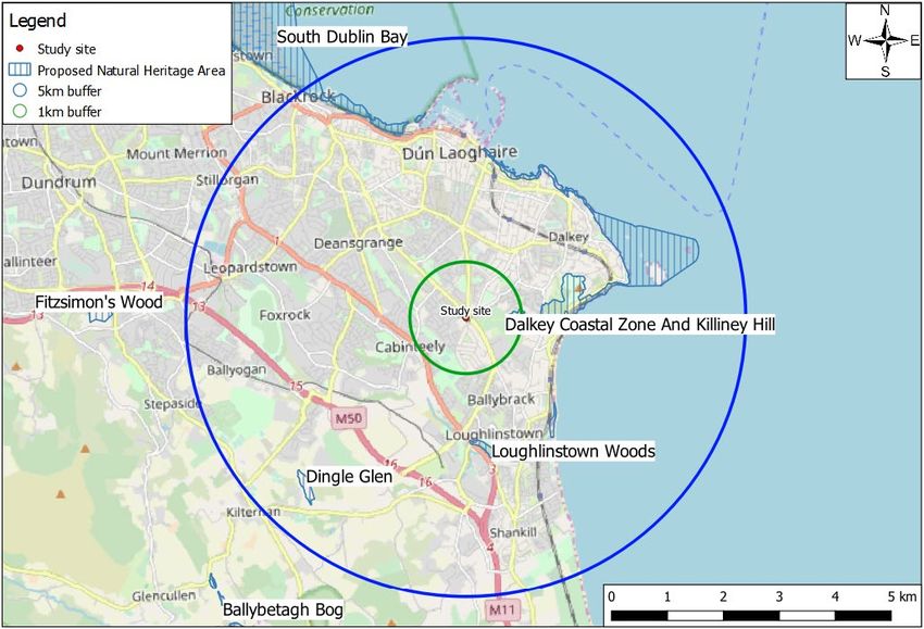
DOCUMENT CONTROL SHEET
6657_RPECIA1_Ecological (Biodiversity) Appraisal

Project No.              6657
Client:                  Strand Court Ltd
Project Name:            Proposed Strategic Housing Development at Churchview Road/Church Road,
                         Killiney, Co. Dublin
Report Name:             Ecological (Biodiversity) Appraisal
Document No.             RPECIA1
Issue No.                01
Date:                    25/06/2019

This document has been issued and amended as follows:
 Issue          Status                                                     Date                   Prepared   Checked

 01             Submission to An Bord Pleanála – draft                     30 May 2019            MH         MH

 02             Submission to An Bord Pleanála – Final                     25 Jun 2019            MH         MH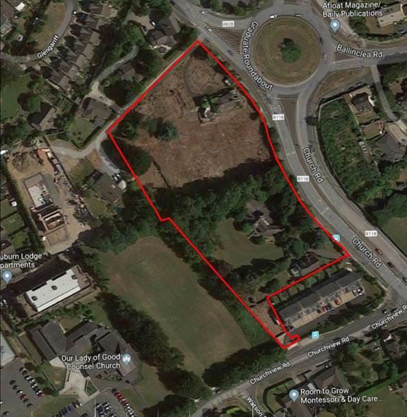
Contents
1     Introduction..................................................................................................................................... 1
2     Methodology ................................................................................................................................... 1
      2.1       Desk study ........................................................................................................................................................ 1
      2.2       Field surveys ..................................................................................................................................................... 2
      2.2.1     Habitats....................................................................................................................................................................................................... 2
      2.2.2     Fauna .......................................................................................................................................................................................................... 3
      2.3       Evaluation of ecological features ...................................................................................................................... 3

3     Baseline environment...................................................................................................................... 4
      3.1       General description of the receiving environment ........................................................................................... 4
      3.2       Designated conservation areas ........................................................................................................................ 5
      3.3       Rare and protected plant species ..................................................................................................................... 7
      3.4       Ecological features............................................................................................................................................ 7
      3.4.1     Habitats....................................................................................................................................................................................................... 7
      3.4.2     Fauna ........................................................................................................................................................................................................10
      3.4.3     Overall ecological valuation of the site ....................................................................................................................................................11

4     The proposed development .......................................................................................................... 11
5     Potential impact of the proposed development ........................................................................... 12
      5.1       Designated conservation areas including Screening for Appropriate Assessment ......................................... 12
      5.2       Habitat loss and disturbance to habitats and species within the site ............................................................. 12

6     Mitigation measures...................................................................................................................... 13
      6.1       Designated Conservation areas ...................................................................................................................... 13
      6.2       Habitats .......................................................................................................................................................... 13
      6.3       Fauna .............................................................................................................................................................. 13
      6.4       Water.............................................................................................................................................................. 14
      6.5       Monitoring...................................................................................................................................................... 16

7     Conclusion ..................................................................................................................................... 16
8     References ..................................................................................................................................... 17

Brady Shipman Martin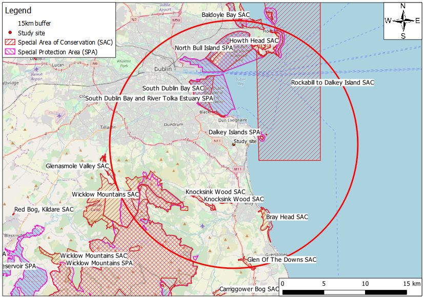
Proposed Strategic Housing Development at Churchview Road/Church Road, Killiney, Co. Dublin
Ecological (Biodiversity) Appraisal

1             Introduction
This document comprises an appraisal of the likely effects on biodiversity (flora and fauna) of a proposed strategic
housing development at Churchview Road and Church Road, Killiney, Co. Dublin.
The potential for any impacts on sites designated as European (Natura 2000) sites under the EU Habitats and Birds
Directives was also appraised, and the results of that study are presented in a separate report (Information for
Screening for Appropriate Assessment).
Brady Shipman Martin was commissioned to undertake the study. The work was carried out by consultant
ecologist Matthew Hague BSc MSc Adv. Dip. Plan. & Env. Law CEnv MCIEEM. Matthew is a highly experienced and
qualified ecologist, with a master’s degree in Ecosystem Conservation and Landscape Management. He has over
17 years of experience in ecological and environmental consultancy, across a wide range of sectors. He is a
Chartered Environmentalist (CEnv) and a full member of the Chartered Institute of Ecology and Environmental
Management (MCIEEM). Matthew recently completed an Advanced Diploma in Planning and Environmental Law,
at King’s Inns.

2             Methodology
2.1           Desk study
A comprehensive desk-based assessment has been undertaken, and a number of ecological site surveys have
been carried out since January 2019, the most recent having taken place in May 2019.
This Ecological Appraisal has regard to the following publications:
    ■    Environmental Protection Agency’s (EPA) Guidelines on the Information to be Contained in Environmental
         Impact Statements (2002) (and revised and draft guidelines 2015 / 2017);
    ■    EPA Advice Notes of Current Practice (in the Preparation of Environmental Impact Statements) (2003) (and
         revised advice notes 2015);
    ■    Guidance on Integrating Climate Change and Biodiversity into Environmental Impact Assessment
         (European Commission, 2013);
    ■    Guidelines for Planning Authorities and An Bord Pleanála on carrying out Environmental Impact
         Assessment (August 2018);
    ■    Guidelines for Assessment of Ecological Impacts of National Road Schemes (Transport Infrastructure
         Ireland (formerly the National Roads Authority), 2009);
    ■    Guidelines for Ecological Impact Assessment in the United Kingdom and Ireland: Terrestrial, Freshwater,
         Coastal and Marine (‘the CIEEM Guidelines’) published by the Chartered Institute of Ecology and
         Environmental Management (CIEEM), September 2018;
    ■    Guidelines for Preliminary Ecological Appraisal published by the Chartered Institute of Ecology and
         Environmental Management (CIEEM), April 2013.
The report has regard to the following legislative instruments:
    ■    The Planning and Development Acts (2000, as amended);
    ■    The Wildlife Act 1976 and the Wildlife (Amendment) Act 2000;
    ■    European Commission (EC) Habitats Directive 92/43/EEC;
    ■    European Commission (EC) Birds Directive 2009/147/EC;
    ■    European Communities (Birds and Natural Habitats) Regulations 2011-2015;
    ■    EIA Directive 2014/52/EU of the European Parliament and of the Council of 16 April 2014;
    ■    Flora (Protection) Order 2015.
    ■    EIA Directive 2014/52/EU of the European Parliament and of the Council of 16th April 2014;

Brady Shipman Martin     6657_2019-06-25_RPECIA1_01                                                               1
Proposed Strategic Housing Development at Churchview Road/Church Road, Killiney, Co. Dublin
Ecological (Biodiversity) Appraisal
■ European Union (Planning and Development) (Environmental Impact Assessment) Regulations 2018 (S.I.
No. 296 of 2018).
The report has regard to the following Policies and Plans:
■ Third National Biodiversity Plan 2017 – 2021 (Department of Culture, Heritage and the Gaeltacht, 2017);
■ Guidelines on Protection of Fisheries During Construction Works in and Adjacent to Waters (Inland
Fisheries Ireland, 2016);
■ Planning for Watercourses in the Urban Environment (Shannon Regional Fisheries Board/Inland Fisheries
Ireland);
■ All-Ireland Pollinator Plan 2015-2020 (National Biodiversity Data Centre);
■ Dún Laoghaire-Rathdown County Development Plan 2016 – 2022, including the associated Natura Impact
Report.
Information was also collated from the sources listed below:
■ Data on rare and protected plant and animal species contained in the following databases:
□ The National Parks and Wildlife Service (NPWS) of the Department of Culture, Heritage and the
Gaeltacht: www.npws.ie ;
□ The National Biodiversity Data Centre (NBDC) www.biodiversityireland.ie ;
□ Birdwatch Ireland www.birdwatchireland.ie ;
□ Bat Conservation Ireland www.batconservationireland.org;
■ Recent aerial photography / drone photography and photographs taken at the Site;
■ Recent and historic ordnance survey mapping www.geohive.ie;
■ Information on protected areas, as well as watercourses, catchments and water quality in the area
available from https://gis.epa.ie/EPAMaps/ ;
■ Information on soils, geology and hydrogeology in the area available from www.gsi.ie ;
■ Information on the status of EU protected habitats in Ireland (NPWS, 2013);
■ Ireland’s 6th National Report to the UN Convention on Biological Diversity (Department of Culture,
Heritage and the Gaeltacht, 2019); and
■ Information on land-use zoning from the online mapping of the Department of the Environment,
Community and Local Government http://www.myplan.ie/en/index.html.
2.2 Field surveys
An initial biodiversity walkover survey was undertaken on 3rd January 2019, with further, more detailed ecological
surveys being undertaken on 12th April 2019. A final ecological survey was undertaken on 15th May 2019. These
surveys enabled comprehensive baseline data on the local ecological environment to be gathered.
2.2.1 Habitats
During the course of the site visits the habitats were identified, described and mapped. Habitats were surveyed
using the guidelines of Smith et al. 1 and were classified using A Guide to Habitats in Ireland 2. Vascular plant
nomenclature follows that of the New Flora of the British Isles 3rd Edition 3.
There are no watercourses on, or connected to, the site. A review of site drainage and potential links to off-site
watercourses was therefore undertaken in conjunction with the project engineers 4.
1
Best Practice Guidance for Habitat Survey and Mapping (Smith, O.Donoghue, O’Hora and Delaney, 2011)
2
A Guide to Habitats in Ireland (Fossitt, 2000)
3
New Flora of the British Isles, 3rd Edition (Stace, 2010)
4
DBFL Consulting Engineers
Brady Shipman Martin 6657_2019-06-25_RPECIA1_01 2Proposed Strategic Housing Development at Churchview Road/Church Road, Killiney, Co. Dublin
Ecological (Biodiversity) Appraisal
2.2.2 Fauna
Birds present on the site were recorded during each of the surveys undertaken and an assessment of habitat
suitability for breeding birds and for species overwintering in Ireland was also carried out.
Signs of large mammals were recorded during the field surveys. This involved a combination of direct sightings
and observations of commuting routes, territorial marking, latrines or feeding signs as well as paw prints, snagged
hairs and piles of bedding material. In addition, a number of entrance holes present in one of the gardens, which
were potentially suitable for use by badgers, were further examined using sticks in the entrances and by placing
motion-activated (infrared) cameras nearby.
A bat survey of all structures and trees within the site proposed for development was undertaken. The site was
searched for roosting, commuting and foraging (feeding) bats as follows:
■ The site was examined in daylight on 3rd January and 12th April 2019. This daylight inspection comprised a
visual inspection of all trees/vegetation within the site, as well as a detailed internal inspection of the two
southern-most houses (known as Briar Hill and Hayfield) and associated structures. All parts of the two
houses, including the attics, were safely accessible and it was possible to undertake a comprehensive
internal and external inspection. An internal inspection of the northern-most house (Culgrenagh) was not
undertaken due to the dilapidated nature of the building. However a detailed photographic survey of the
house was subsequently undertaken and these photographs were reviewed in preparing this report;
■ Bat emergence surveys, using bat detectors, were undertaken at Culgrenagh on the night of 15th May
2019. The survey commenced 30 minutes before sunset (21.17) and continued for approximately 1 hour
after sunset (until 22.20). The building was surveyed from vantage points chosen to maximise visual
coverage of the building, and bat activity was recorded using handheld ultrasound detectors (a Batbox
Duet detector and an Echometer Touch). On completion of the emergence survey the tree lines and other
buildings were surveyed to look for foraging/commuting bats. Weather conditions were optimal for bat
survey work on the night of the survey.
The site was evaluated for the presence of and suitability for lepidoptera (butterflies and moths), amphibians
(common frog and smooth newt) and reptiles (common/viviparous lizard).
2.3 Evaluation of ecological features
The methodologies used to determine the value of ecological resources, to characterise impacts of proposed
Project and to assess the significance of impacts and any residual effects are in accordance with the NRA (TII)
Guidelines for Assessment of Ecological Impacts of National Road Schemes 5. This methodology is consistent with
the CIEEM Guidelines for Ecological Impact Assessment in the United Kingdom and Ireland – Terrestrial,
Freshwater, Coastal and Marine 6.
In accordance with the NRA (TII) Guidelines, impact assessment is undertaken of sensitive ecological receptors
(Key Ecological Receptors) within the Zone of Influence of the proposed Project. According to the guidelines, the
Zone of Influence is the ‘effect area’ over which change resulting from the proposed Project is likely to occur and
the Key Ecological Receptors are defined as features of sufficient value as to be material in the decision-making
process for which potential impacts are likely. In the context of the proposed development at Churchview Road, a
Key Ecological Receptor is defined as any feature valued as follows:
International Importance;
National Importance;
County Importance; and
5
NRA (TII), 2009. Guidelines for Assessment of Ecological Impacts of National Road Schemes. National Roads Authority
6
The CIEEM Guidelines’, CIEEM, September 2018
Brady Shipman Martin 6657_2019-06-25_RPECIA1_01 3Proposed Strategic Housing Development at Churchview Road/Church Road, Killiney, Co. Dublin
Ecological (Biodiversity) Appraisal
Local Importance (Higher Value).
Features of local importance (Lower Value) and features of no ecological value are not considered to be Key
Ecological Receptors.
3 Baseline environment
3.1 General description of the receiving environment
The proposed development site (see Figure 1) is located to the south west of the Graduate Roundabout and
Church Road in Killiney, Co Dublin. It is approximately bounded by Churchview Road and the Fairhaven
development to the south and by existing residential development to the north and west. The Auburn Lodge
apartments, as well as Our Lady of Good Counsel School and Church, and a playing field, are located immediately
to the west.
The site has a total area of c.1.59 hectares presently and accommodates 3 no. detached houses, known as
Culgrenagh (in a state of significant disrepair), Briar Hill, and Hayfield. Briar Hill and Hayfield, the southern-most
houses on the site, are surrounded by suburban gardens, with lawns and ornamental planting as well as scrub and
mature trees and shrubs.
Culgrenagh, the most significant of the three properties, was formerly the site of a mature garden and trees.
However the site was substantially cleared between 2013 and 2015 and is now dominated by recolonising bare
ground, with pockets of scrub and re-establishing garden plants. A number of mature trees, including two
significant blue cedars and a Monterey pine remain in the former garden of Culgrenagh. This property is
separated from Briar Hill by a large stone wall (a townland boundary) and an associated line of mature trees
(horse chestnut, Norway maple and sycamore) is located on the southern side of this wall. Both Briar Hill and its
neighbour, Hayfield, are set in abandoned gardens, with areas of scrub, including bramble and laurel, developing.
A mixed line of mature trees, mainly beech and eucalyptus, but including Norway maple, Lawson cypress and elm,
is present along the western boundary of these two gardens.
The nearest watercourse to the site, Kill-O-The-Grange Stream (EPA water features database 7), is located c.650m
to the south west at its closest point. This stream discharges to the Irish Sea at Ballybrack, approximately 200m
north of the mouth of the Shanganagh River. It does not drain directly into any European sites – Rockabill to
Dalkey Island SAC and Dalkey Islands SPA are approximately 1.5km and 2.9km from the mouth of the stream
respectively.
7
https://gis.epa.ie/EPAMaps/
Brady Shipman Martin 6657_2019-06-25_RPECIA1_01 4Proposed Strategic Housing Development at Churchview Road/Church Road, Killiney, Co. Dublin
Ecological (Biodiversity) Appraisal
Figure 1: Location of the proposed development site at Churchview Road/Church Road 8 (Note: the red line indicates
the approximate study area boundary. The application area is shown on the additional documentation that
accompanies the planning application)
3.2 Designated conservation areas
No sites designated for nature conservation are present on the site, however a separate report (Information for
Screening for Appropriate Assessment) has been prepared in order to address any potential impacts on European
sites.
There are 17 European sites (11 SACs and 6 SPAs) located within a 15km radius of the proposed development (see
Figure 2). The nearest designated sites are Rockabill to Dalkey Island SAC and Dalkey Islands SPA, approximately
8
Google Maps imagery
Brady Shipman Martin 6657_2019-06-25_RPECIA1_01 5Proposed Strategic Housing Development at Churchview Road/Church Road, Killiney, Co. Dublin Ecological (Biodiversity) Appraisal 3km to the east. There is a potential pathway between the proposed project and coastal European sites via the local surface water drainage network. It is considered in the AA Screening report that no sites other than offshore sites have any connection (pathway) with the proposed project, due to their locations and the features (qualifying interests) for which they are designated, as well as the scale of the development proposed. Figure 2: Study site at Churchview Road/Church Road showing European sites (with 15km radius from the site) The nearest sites designated for nature conservation, not otherwise designated as European sites (see Figure 3), are Dalkey Coastal Zone and Killiney Hill proposed Natural Heritage Area (pNHA site code 001206, c.700m to the east), Loughlinstown Woods pNHA (site code 001211, c.2.2km to the south), Dingle Glen pNHA (site code 001207, c.4.0km to the south west) and Fitzsimon’s Wood pNHA (site code 001753, c.6.4km to the west). These sites are included in this report in order to appraise their potential to act in support of the European sites, for example by acting as stepping stones or feeding areas for species moving between the European sites. Brady Shipman Martin 6657_2019-06-25_RPECIA1_01 6
Proposed Strategic Housing Development at Churchview Road/Church Road, Killiney, Co. Dublin
Ecological (Biodiversity) Appraisal
Figure 3: Designated Conservation Areas (non-European Sites) in relation to the study site
3.3 Rare and protected plant species
The NPWS and NBDC databases were consulted with regard to rare species 9 and species protected under the
Flora Protection Order 10. There are no known records of rare or protected plant species within the immediate
vicinity of the proposed project.
According to the NBDC database there are no records of protected or rare plants within the 2km grid square
(O22M) that covers the site. No protected or rare plants were recorded during the surveys undertaken, and given
the disturbed nature of the site and the fact that it has been occupied by suburban gardens for a very significant
period the habitat is unsuitable for any protected species.
3.4 Ecological features
3.4.1 Habitats
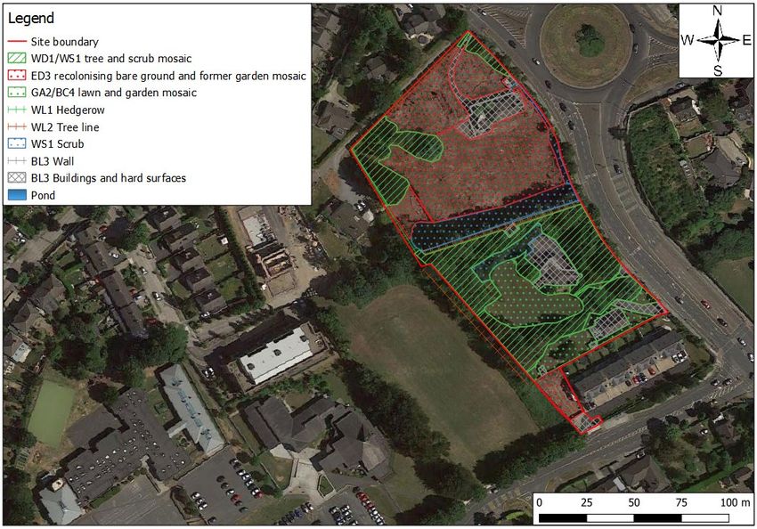
The habitats present on the proposed development site are described in this section and are shown in Figure 4.
The dominant habitat in the northern part of the site (Culgrenagh) is a recolonising bare ground and former
garden mosaic (ED3). This area was formerly a mature, tree-filled garden that was cleared a number of years ago,
leaving significant bare patches. The area is heavily dominated by herb Robert (Geranium robertianum), with
several other native and non-native garden species also present, such as forget-me-not (Myosotis arvensis),
9
The Irish Red Data Book 1 – Vascular Plants (Curtis & McGough, 1988)
10
Flora Protection Order (2015)
Brady Shipman Martin 6657_2019-06-25_RPECIA1_01 7Proposed Strategic Housing Development at Churchview Road/Church Road, Killiney, Co. Dublin Ecological (Biodiversity) Appraisal foxglove (Digitalis purpurea), bush vetch (Vicia sepium), native bluebell (Hyacinthoides non-scripta) and rosebay willowherb (Chamerion angustifolium). Substantial parts of the site, in particular the southern half, but also sections of the northern boundaries and the north west corner comprise a native and non-native tree and scrub mosaic (WD1/WS1) with hedgerows (WL1) and tree lines (WL2) also present. A wide range of tree and shrub species are present throughout the site, including Lawson cypress (Chamaecyparis lawsoniana), Monterey cypress (Cupressus macrocarpa), beech (Fagus sylvatica), cherry laurel (Prunus laurocerasus), elder (Sambucus nigra), hawthorn (Crataegus monogyna), birch (Betula pendula), holly (Ilex aquifolium), poplar (Populus sp.), Norway Maple (Acer platanoides), sycamore (Acer pseudoplatanus), lime (Tilia sp.), flowering cherry (Prunus avium), horse chestnut (Aesculus hippocastanum), yew (Taxus baccata) and griselinia (Griselinia littoralis). A large Monterey pine (Pinus radiata) is located near the north western boundary of Culgrenagh and a blue cedar (Cedrus atlantica ‘glauca’) and a Japanese cedar (Cryptomeria japonica) are also present in this garden. Patches of scrub (WS1) are present throughout the site, particularly in a 10-15m wide strip on the northern side of the Culgrenagh boundary wall, and to the west of Briar Hill. The scrub is dominated by brambles (Rubus fruticosus agg.), with small areas of buddleia (Buddleja davidii), nettles (Urtica dioica) and common hogweed (Heracleum sphondylium) also present. The southern part of the site (the gardens of Briar Hill and Hayfield, not occupied by scrub or trees) comprise a lawn and garden plant mosaic type habitat (GA2/BC4). The remainder of the site comprises buildings, driveways paved areas and other hard surfaces (BL3). No species listed on the Third Schedule of the European Communities (Birds and Natural Habitats) Regulations (2011-2015), were recorded within the site proposed for development. However, several such invasive alien plant species, most notably giant hogweed (Heracleum mantegazzium) and Japanese knotweed (Fallopia japonica), as well as three-cornered garlic (Allium triquetrum), sea-buckthorn (Hippophae rhamnoides) and Nuttal’s waterweed (Elodea nutallii) (an aquatic plant) have been recorded extensively within the surrounding areas. Brady Shipman Martin 6657_2019-06-25_RPECIA1_01 8
Proposed Strategic Housing Development at Churchview Road/Church Road, Killiney, Co. Dublin
Ecological (Biodiversity) Appraisal

Figure 4: Habitat map for the proposed development site at (Note: the red line indicates the approximate study area boundary. The application area is shown on the
additional documentation that accompanies the planning application) 11

11
     Google Maps imagery
Brady Shipman Martin       6657_2019-06-25_RPECIA1_01                                                         9
Proposed Strategic Housing Development at Churchview Road/Church Road, Killiney, Co. Dublin Ecological (Biodiversity) Appraisal 3.4.2 Fauna 3.4.2.1 Bats All Irish bat species are fully protected under the Wildlife Act (1976) and subsequent amendments, and under the EU Habitats Directive, via the European Communities (Birds and Natural Habitats) Regulations, 2011-2015. The scrub and trees on the site are suitable for use by commuting and foraging bats, and a number of the mature trees contain features that may be suitable for use by roosting bats, albeit only occasionally and in small numbers. No bat roosts were confirmed on the site and no signs of roosting bats such as droppings or staining were recorded in any of the buildings on the site. No bat activity was recorded anywhere on the site within an hour of sunset on the night of the survey, indicating a low likelihood of bats roosting on or very close to the site. Despite perfect weather conditions bat activity was limited to a single Leisler’s bat, which was observed to be foraging along the tree line/townland boundary wall separating Culgrenagh from the southern two houses. This bat foraged in the area for about 12 minutes before leaving the site in a south-westerly direction. 3.4.2.2 Birds Birds, as well as their nests and eggs, are fully protected under the Wildlife Act (1976) and subsequent amendments. The bird community present is quite typical of such a site, with long-tailed tit, blue tit, great tit, blackbird, woodpigeon, pied wagtail, song thrush, goldfinch, wren, rook, hooded crow and magpie (all species of least conservation concern – green listed on the list of Birds of Conservation Concern in Ireland 2014 to 2019 (Colhoun and Cummins 2013)) regularly present. Buzzard, another green-listed species, was recorded twice flying high over the site. Four amber listed species (of medium conservation concern), robin, house sparrow, starling and goldcrest, were also recorded. No red list species (of high conservation concern) were recorded on any of the field visits. An appraisal of the site was undertaken to assess its suitability for use by birds that favour open farmland or rough pasture, such as lapwing and curlew (red list species) or pale-bellied Brent goose (amber list). However, no signs of these or any similar species were recorded and the site itself is not of any significant value for these species. 3.4.2.3 Large mammals Badgers are fully protected under the Wildlife Act (1976) and subsequent amendments. Extensive surveys for badger activity have been undertaken at the site, including the use of passive infrared (motion-activated) cameras at the site of a potential badger sett. However, no signs of badgers have been recorded and the entrance holes were confirmed to be at a fox den. Foxes are not protected under the Wildlife Acts. No evidence of otters, protected under the Wildlife Act (1976) and subsequent amendments, and under the EU Habitats Directive, via the European Communities (Birds and Natural Habitats) Regulations, 2011-2015, was recorded. 3.4.2.4 Other fauna A small artificial/garden pond, approximately 10-15cm in depth, and 1.5m2 in area is present to the immediate north of Culgrenagh. The pond is partially filled with rubble and debris however a small number of frog tadpoles were noted in the pond in May 2019. Frogs are protected under the Wildlife Act (1976) and subsequent amendments. However, frogs are common and widespread and may spawn in any temporary water body. This pond dries out in the summer and is of transient importance for the local frog population. No evidence of reptiles (common lizard), protected under the Wildlife Act (1976) and subsequent amendments, was recorded. Brady Shipman Martin 6657_2019-06-25_RPECIA1_01 10
Proposed Strategic Housing Development at Churchview Road/Church Road, Killiney, Co. Dublin
Ecological (Biodiversity) Appraisal

3.4.3         Overall ecological valuation of the site
The proposed development site is not under any wildlife or conservation designation. Furthermore, no rare,
threatened or legally protected plant species, as listed in the Irish Red Data Book 1 – Vascular Plants (Curtis &
McGough, 1988), the Flora Protection Order, 2015 or the EU Habitats Directive, are known to occur within the
site.
An active fox earth, with two entrances, is located on the southern boundary of Culgrenagh and following an
extended period of monitoring in January 2019, using a passive infrared camera, it was confirmed that there is no
badger activity at the site.
All of the bird species recorded are very common, and no rare species were noted.
Internal inspections of Briar Hill and Hayfield, including a comprehensive search of the attics of both houses,
revealed no evidence of bat activity, such as bat droppings, staining or feeding remains. It is considered that bats
are not roosting in these houses. Culgrenagh, unlike the other houses is in a significant state of disrepair, having
been badly damaged by fire and vandalism. As such it is not possible to safely inspect the house internally for
signs of bats, however, based on the internal and external inspections undertaken by the author and a review of a
detailed photographic survey undertaken of all safely accessible areas it is concluded that there is a very low
likelihood of roosting bats being present in the house. Furthermore, a full bat emergence survey, using bat
detecting equipment, was undertaken on 15th May 2019. The survey confirmed that no roosting bats are using the
house. Overall, bat activity at the proposed development site is low and no bats were confirmed as roosting
within the site.
Other than the small number of tadpoles in the garden pond, no evidence of any other protected animal species
such as lizards or hedgehogs, or rare or protected plants, was recorded during the surveys carried out, and the
habitats present are not suitable for such species.
Overall, with the exception of the small pond, which has some local, temporary, ecological value, the Churchview
Road site has no key ecological receptors as defined by the ecological resource valuations presented in the
National Roads Authority/Transport Infrastructure Ireland Guidelines for Assessment of Ecological Impacts of
National Road Schemes (NRA/TII, 2009 (Rev. 2)).

4             The proposed development
Strand Court Limited is seeking planning permission for a strategic housing development at Churchview Road and
Church Road, Killiney, Co. Dublin. The site is located to the west of the Graduate Roundabout and Church Road, to
the north of Fairhaven and Churchview Road, and to the east of an area of open space.
The proposed development will consist of:
     •    The demolition of 3 no. existing dwellings known as Culgrenagh, Briar Hill, and Hayfield;
     •    The construction of 210 no. residential units (apartments) in 3 no. blocks (A, B and C) ranging in height
          from 3 to 7 storeys, including lower ground floor / basement level, incorporating 27 no. 1-bed units, 160
          no. 2-bed units and 23 no. 3 bed units;
     •    Apartment Block C includes a childcare facility with a gross floor area of 203 sq.m, with an adjacent
          external play area, and Apartment Block B includes a resident’s amenity facility with a gross floor area of
          130 sq.m;
     •    A total of 227 no. car parking spaces are proposed to be provided, including 186 no. spaces at
          basement/undercroft level and 41 no. surface car parking spaces, including parking for visitors and set-
          down parking for the childcare facility. The development provides a total of 348 no. cycle parking spaces
          (surface and basement level). Bin storage and plant areas are also provided at basement level.

Brady Shipman Martin     6657_2019-06-25_RPECIA1_01                                                                 11
Proposed Strategic Housing Development at Churchview Road/Church Road, Killiney, Co. Dublin
Ecological (Biodiversity) Appraisal
The associated site development and infrastructural works will include upgrade of the existing access from
Churchview Road, which also serves the Fairhaven development, and provision of an internal access road,
associated upgrade works to Churchview Road, foul and surface water drainage, attenuation tanks, open space
areas, hard and soft landscaping, 1 no. electricity substation, boundary treatments and all ancillary works on a
total site area of 1.59ha.
5 Potential impact of the proposed development
5.1 Designated conservation areas including Screening for Appropriate
Assessment
As previously stated, the potential for any impacts on European sites under the EU Habitats and Birds Directives
was considered. Full results of that study are presented in a separate report (Information for Screening for
Appropriate Assessment). The following paragraphs comprise a summary of the conclusions outlined in that
report:
This report concludes on the best scientific evidence that it can be clearly demonstrated that no elements
of the project will result in any likely significant effects on Qualifying Interests/Special Conservation
Interests of any relevant European site, either on their own or in-combination with other plans or
projects, in view of their conservation objectives.
The project will not adversely affect the integrity of any European site and as such no mitigation
measures are required for the protection of these European sites.
It is considered that this report provides sufficient relevant information to allow the Competent Authority
(An Bord Pleanála) to carry out an AA Screening, and reach a determination that the proposed
development will not affect the integrity of any of the relevant European sites under Article 6 of the
Habitats Directive (92/43/EEC) in light of their conservation objectives.
5.2 Habitat loss and disturbance to habitats and species within the site
The development will involve the removal of much of the existing abandoned garden habitat on the site. These
habitats are of no more than low local significance although they do provide some wildlife (bird nesting) habitat
and act as corridors for movement. This loss is considered to be a probable permanent impact at the site level
only. The landscape design that is proposed will ensure that there will be no residual impact from the loss of
habitat on the site (refer to Brady Shipman Martin Drawing 6657_302 for details).
No bat roosts will be lost as a result of the proposed development, however the loss of vegetation on the site will
reduce the feeding opportunities for bats such as Leisler’s bat (recorded as feeding over the site during the bat
survey). New illumination will be provided as part of the development. This will result in, at worst, a permanent
minor negative impact, at the site level, on roosting/foraging bats.
There will be a minor impact, at the site level only, on frogs, due to the removal of the small artificial pond.
It is not expected that there will be any impacts on badgers and other large mammals, reptiles, lepidoptera or
other species groups as a result of the proposed development. In addition there will be no loss of habitat utilised
by overwintering birds, such as pale-bellied Brent goose, lapwing or curlew.
There will be no transfer of invasive plant material during the construction phase that could potentially lead to
species such as giant hogweed or Japanese knotweed becoming established in the area. The construction
methodology (refer to the Construction & Environmental Management Plan (CEMP) prepared by DBFL Consulting
Engineers) will ensure that no invasive species are introduced, either deliberately or inadvertently, to the site.
Brady Shipman Martin 6657_2019-06-25_RPECIA1_01 12Proposed Strategic Housing Development at Churchview Road/Church Road, Killiney, Co. Dublin Ecological (Biodiversity) Appraisal 6 Mitigation measures 6.1 Designated Conservation areas No designated conservation areas will be impacted in any way by the proposed development and no specific mitigation measures are required for the protection of such sites, including European sites. Full details in relation to European sites are provided in the accompanying report (Information for Screening for Appropriate Assessment). 6.2 Habitats All site clearance and landscaping works will comply with current legislative requirements and best practice. All retained trees that are within or close to the working wayleave of the proposed development will be protected in accordance with the requirements of British Standard BS5837:2012 Trees in Relation to Design, Demolition and Construction’ – Recommendations, with protective fencing being installed around all trees to be retained, prior to commencement of development. The planting proposed for the development at Churchview Road will, wherever possible and taking into account the setting, comprise a mixture of native and naturalised trees and shrubs, preferably of local provenance. The planting will also incorporate a range of species that will attract feeding invertebrates, including moths, butterflies and bees. It will take account of and implement the relevant objectives of the All-Ireland Pollinator Plan 2015- 2020 and a biodiverse flower mix will be incorporated into the planting to provide sites for invertebrates including moths, flies and beetles and consequently food for bats and other wildlife. This will include some of the following plants: Hebe, lavender, jasmine, rosemary, violets, thyme, blue bells, wisteria, cone flowers and sunflowers (beneficial to a wide variety of insects). The planting plans and landscaping proposals will ensure that no invasive species are introduced, either deliberately or inadvertently, to the site. 6.3 Fauna Where practicable, the removal of trees and other features suitable for use by nesting birds shall be undertaken outside the bird nesting season (avoiding the period 1st March to 31st August). Should the construction programme require vegetation clearance between March and August bird nesting surveys shall be undertaken by suitably experienced ecologists. If no active nests are recorded, vegetation clearance shall take place within 24 hours. In the event that active nests are observed, an appropriately sized buffer zone shall be maintained around the nest until such time as all the eggs have hatched and the birds have fledged. Once it is confirmed that the birds have fledged and no further nests have been built or occupied, vegetation clearance may take place. Care must be taken during development to ensure that common lizards, common frogs and smooth newts (which are all protected under the Wildlife Act (1976) and subsequent amendments) are not harmed. This is particularly true in the garden of Culgrenagh, which contains a very small ornamental pond and within which a small number of tadpoles were recorded in May 2019. As stated in Section 5.2, due to the very small size of the pond and the fact that it is not permanently wet it is not expected that there will be any significant impacts on amphibians or reptiles as a result of the proposed development. Nevertheless, the pond will be removed when it is dry or when it is confirmed that there are no frogs present. No badger setts are present on the site and no badger groups are likely to be affected by the proposed development. It is therefore not necessary to apply for a licence to disturb badgers (under Section 23 of the Wildlife Act, 1976, as amended) in order to permit the development to proceed. No bat roosts have been recorded at the Churchview Road site and it will not be necessary to apply to the Minister for Culture, Heritage and the Gaeltacht for a derogation licence under Regulation 54 or 55 of the Brady Shipman Martin 6657_2019-06-25_RPECIA1_01 13
Proposed Strategic Housing Development at Churchview Road/Church Road, Killiney, Co. Dublin
Ecological (Biodiversity) Appraisal
European Communities (Birds and Natural Habitats) Regulations 2011 (S.I. 477/2011) in order to disturb or to
remove any bat roosts.
It is however acknowledged that on any site there remains the possibility that small numbers of bats could avail of
even very minor crevices or cracks for temporary roosting. Therefore, in line with good practice, the houses and
trees shall be examined prior to removal to confirm that they are not in use as roost sites at that time. Where the
absence of bats is confirmed the buildings or trees may be removed without further measures. If surveying cannot
rule out the presence of bats, then the buildings or trees will require closer examination at the time of removal.
For the buildings, careful roof stripping if required (slates and timbers) must be supervised by a bat specialist.
The proposed lighting for the scheme (prepared by Penston MEP Consulting Ltd), has been designed in accordance
with the following guidelines:
Bats and Lighting – Guidance Notes for Planners, Engineers, Architects and Developers (Bat
Conservation Ireland, 2010);
Guidance Notes for the Reduction of Obtrusive Light GN01 (Institute of Lighting Professionals,
2011);
Bats and Lighting in the UK – Bats and the Built Environment Series (Institute of Lighting
Professionals, September 2018).
The lighting scheme as designed will adhere to the following lighting design characteristics:
The minimum level of appropriate/required lighting level will be provided within the
developed/residential areas;
Light standards will be fitted with low intensity, horizontal cut-off LED light fittings employing a
narrow directional light or cowled light. This will avoid the effect of light spill arising;
The lighting includes dimming by 30% post curfew hours;
Light standards and associated lighting will be directed away from areas of open space;
No floodlighting will be used in the development.
A total of four bat boxes (e.g. Schwegler 2F bat boxes or 1FR bat tubes) will be provided within the site in unlit
areas at a height of 3 metres or greater and away from direct clutter, following the advice of an appropriately
experienced bat specialist. In addition, a triple cavity swift box, such as Schwegler 17A (or a number of swift
bricks), will be installed within the development, under the supervision of a suitably qualified ecologist.
6.4 Water
Full details of the surface water and foul drainage proposals are contained within the project Engineering Services
Report prepared by DBFL Consulting Engineers that accompanies the planning application.
In order to ensure there are no impacts on water quality in general during site clearance and construction, a
Construction & Environmental Management Plan has been prepared by DBFL Consulting Engineers for the
proposed development. This Plan (in particular Section 8 (Sediment and Water Pollution Control Plan) and Section
10 (Drainage Works)) sets out the precautions that will be implemented as part of the construction methodology
to avoid any pollution from construction activities via run-off to the surface water drainage network.
As part of the implementation of the Construction & Environmental Management Plan, the contractor will take
adequate precautions to avoid any pollution from construction activities via run-off to the surface water drainage
network. Temporary attenuation and settlement facilities may be required in appropriate locations during
construction. In order to further ensure that there are no impacts on either designated sites or on water quality in
general during the construction works, all hazardous substances, such as fuels, oils, cement and concrete
products will be stored on-site in secure, bunded areas remote from drainage connections to the existing surface
water drainage network.
Brady Shipman Martin 6657_2019-06-25_RPECIA1_01 14Proposed Strategic Housing Development at Churchview Road/Church Road, Killiney, Co. Dublin
Ecological (Biodiversity) Appraisal
The implementation and effectiveness of the Construction & Environmental Management Plan measures will be
inspected and recorded regularly during the entire works period and where deficiencies or faults are identified
the contractor will immediately remedy them.
There is an existing 225mm diameter concrete surface water sewer in Church Road to the east of the site which
discharges in a north-west direction. Additionally, there is another existing 225mm diameter concrete surface
water sewer in Church Road which discharges in a southerly direction and continues along Churchview Road.
There is no existing public surface water sewage infrastructure within the proposed site.
Surface water management for the proposed development is designed to comply with the ‘Greater Dublin
Strategic Drainage Study (GDSDS) Regional Drainage Policies Technical Document – Volume 2, New Developments,
2005’ and the ‘Greater Dublin Regional Code of Practice for Drainage Works, V6.0 2005’. CIRIA Design Manuals
C753, C697 and C609 have also been used to design the surface water drainage system within the site.
It is proposed to use a sustainable urban drainage system (SuDS) approach to storm water management
throughout the site. The overall strategy aims to provide an effective system to reduce run-off rates, volumes and
frequency, reducing pollutant concentrations in storm water, contributing to amenity, aesthetics and biodiversity
enhancement and allow for the maximum collection of rainwater for re-use where possible. In addition, SuDS
features aim to replicate the natural characteristics of rainfall run-off for any site by providing control of run-off at
source and this has been achieved by the current proposals.
SuDS are a requirement of Dun Laoghaire Rathdown County Council under their ‘Regional Code of Practice for
Drainage Works’ and ‘The Greater Dublin Strategic Drainage Study’. Additionally, these systems are recommended
under the 2009 guidelines, ‘The Planning System and Flood Risk Management’.
Due to the large extent of development within the site it is not proposed to provide long-term storage. However,
the modelling presented in the Engineering Services Report (DBFL Consulting Engineers) has concluded that the
final combined discharge to sewer from the site will be kept at (or below) the total permissible discharge rate for
the site, taking into account a 100 year return period for flood waters, including a 10% increase for climate
change.
• There will be no operational impacts related to surface water management as a result of the proposed
development.
There is an existing 225mm diameter foul sewer located in Churchview Road, approximately 200m to the south-
west of the site, at the entrance to Auburn Drive. There is no existing public foul sewerage infrastructure within
the proposed development site.
It is proposed to discharge the proposed foul water drainage from the development to the existing 225mm
diameter foul sewer located in the footpath on Churchview Road. This connects to the 225mm sewer shown on
Irish Water records at the entrance to Auburn Drive and ultimately discharges to the Shanganagh Wastewater
Treatment Plant.
Foul sewers have been designed and will be constructed in accordance with the Irish Water’s ‘Standard Details for
wastewater infrastructure’ and ‘Code of practice for wastewater infrastructure’. In addition, foul sewers have
been designed to Building Regulations and specifically in accordance with the principles and methods set out in
EN 752:2008 and DOE ‘Recommendations for Site Development Works’.
Foul sewage will be piped to Shanganagh Wastewater Treatment Works for treatment and ultimate discharge to
the Irish Sea, which, according to information (coastal water quality data) provided by the EPA
(https://gis.epa.ie/EPAMaps/), is classified as unpolluted.
Shanganagh Wastewater Treatment Works has been upgraded as part of the Shanganagh Bray Wastewater
Project, to cater for existing and all projected future catchment development flows. It has the capacity to treat
effluent from 186,000 population equivalent with the potential to increase capacity to 248,000 in the future.
Brady Shipman Martin 6657_2019-06-25_RPECIA1_01 15Proposed Strategic Housing Development at Churchview Road/Church Road, Killiney, Co. Dublin
Ecological (Biodiversity) Appraisal
The capacity available at Shanganagh Wastewater Treatment Works is sufficient to accommodate the inflow
arising from the proposed development at Churchview Road, as well as other developments in the area and it will
therefore be possible to maintain the unpolluted status of the coastal waters.
• There will be no operational phase impacts related to foul water management as a result of the proposed
development.
The Flood Risk Assessment for the proposed residential development (prepared by DBFL Consulting Structural and
Civil Engineers and presented within the Engineering Services Report (Section 6) was undertaken in accordance
with the requirements of the Planning System and “Flood Risk Management Guidelines for Planning Authorities”,
November 2009. Following the flood risk assessment stages, it was determined that the site is within Flood Zone C
as defined by the Guidelines. Zone C is considered appropriate for development such as is proposed.
• There will be no operational phase impacts related to flooding as a result of the proposed development.
6.5 Monitoring
A suitably experienced ecologist will be appointed for the duration of the construction phase and regular monitoring
of all construction works will take place to ensure the correct and full implementation of the mitigation measures
set out in this report.
• The project ecologist will monitor all site clearance activities in order to ensure compliance with
legislative requirements and the commitments set out in the planning application documentation. This
includes the monitoring of the installation of protective measures, to avoid frog and breeding bird
mortality and to ensure site lighting does not disturb bats;
• The project ecologist will maintain regular contact with the following organisations as required:
o Dún Laoghaire-Rathdown County Council (Biodiversity Officer);
o National Parks and Wildlife Service (Wildlife Ranger);
• All monitoring tasks will be recorded and logged for inspection by the site manager.
The bat and swift boxes installed on the site will be checked annually for a period of five years post construction, to
ensure that they continue to be accessible to these species.
7 Conclusion
The proposed development will result in the removal of a number of abandoned suburban gardens. A number of
substantial trees will be retained.
The removed gardens and demolished houses will be replaced with new residential development and associated
public open space and landscaped areas, including areas of ecologically sensitive planting as well as bat and bird
boxes. There will be no long-term residual impact on any ecological receptors, either within or in the vicinity of the
site, or associated with any site designated for nature conservation as a result of the proposed development.
Brady Shipman Martin 6657_2019-06-25_RPECIA1_01 16Proposed Strategic Housing Development at Churchview Road/Church Road, Killiney, Co. Dublin Ecological (Biodiversity) Appraisal 8 References Bat Conservation Ireland 2010. Bats and Lighting - Guidance Notes for Planners, engineers, architects and developers. Bat Conservation Ireland. Accessed online at: http://www.batconservationireland.org/pubs/reports/BCIrelandGuidelines_Lighting.pdf CIEEM (2018). Guidelines for Ecological Impact Assessment in the UK and Ireland: Terrestrial, Freshwater, Coastal and Marine. Chartered Institute of Ecology and Environmental Management, Winchester, United Kingdom Council of the European Communities (1992). Council Directive of 21 May 1992 on The Conservation of Natural Habitats and of Wild Fauna and Flora (92/43/EEC). O. J. L 206/35, 22 July 1992 Council Directive 79/409/EEC on the Conservation of Wild Birds. (The EU Birds Directive) Council Directive 2000/60/EC of the European Parliament and of the Council establishing a Framework for the Community Action in the Field of Water Policy (The Water Framework Directive) Department of Culture, Heritage and the Gaeltacht. 2017. Ireland’s Third National Biodiversity Plan DG Environment. 2003. Interpretation Manual of European Union Habitats. European Commission EPA. 2002. Guidelines on the information to be contained in Environmental Impact Statements EPA, 2003. Advice Notes on Current Practice (in the preparation of Environmental Impact Statements) Environmental Protection Agency (2017). Revised Guidelines on the Information to be contained in Environmental Impact Statements (Draft). Environmental Protection Agency, Dublin Environmental Protection Agency (2017). Advice Notes of Current Practice in the Preparation of Environmental Impact Statements (Draft). Environmental Protection Agency, Dublin Fossitt J. 2000. A Guide to Habitats in Ireland. Heritage Council. Hayden T. & Harrington R. 2001. Exploring Irish Mammals. Town House Dublin Kelleher, C. and Marnell, F. 2006. Bat Mitigation Guidelines for Ireland. Irish Wildlife Manuals, no. 25. National Parks and Wildlife Service. Department of Arts, Heritage and the Gaeltacht. Dublin. McGarrigle M., Lucey J. & Ó’Cinnéide M. 2010. Water Quality in Ireland 2007 – 2009. Environmental Protection Agency National Parks and Wildlife Service. 2008. The Status of EU Protected Habitats and Species in Ireland. Department of Environment, Heritage and Local Government NRA. 2009. Guidelines for Assessment of Ecological Impacts of National Road Schemes. National Roads Authority Smith G. F., O’Donoghue P., O’Hora K. and Delaney E. 2010. Best Practice Guidance for Habitat Survey and Mapping. Heritage Council Stace S. 2010. New Flora of the British Isles. Third Edition. Cambridge University Press Webb D.A., Parnell J. & Doogue D. 1996. An Irish Flora. Dundalgan Press Brady Shipman Martin 6657_2019-06-25_RPECIA1_01 17
Brady Shipman Martin
DUBLIN
 Canal House
 Canal Road
 Dublin 6
 +353 1 208 1900
CORK
 Penrose Wharf Business Centre
 Penrose Wharf
 Cork
 +353 21 242 5620
LIMERICK
  11 The Crescent
  Limerick
  +353 61 315 127

mail@bradyshipmanmartin.com
www.bradyshipmanmartin.com
You can also read