Appendix K: Aboriginal Cultural Heritage Assessment Addendum Report (Austral Archaeology, 2020) - Uungula Wind Farm - Major Projects
←
→
Page content transcription
If your browser does not render page correctly, please read the page content below
Environmental Impact Statement
Uungula Wind Farm
Appendix K: Aboriginal Cultural Heritage Assessment
Addendum Report (Austral Archaeology, 2020)
May 2020

                                      CWP Renewables Pty Ltd
                                      (02) 4013 4640

                                      P.O. Box 1708 Newcasltle NSW 2300
                                      cwprenewables.com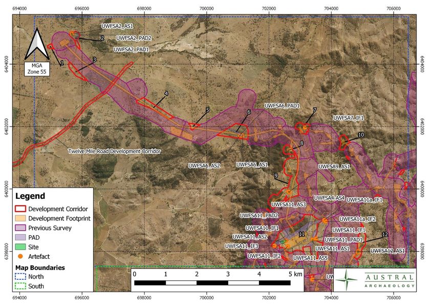
1961- Uungula Wind Farm, Uungula

  Uungula Wind Farm, Uungula New
              South Wales:
Aboriginal Archaeological Survey Report
              (Addendum)

                                      FINAL REPORT

                                   CWP Renewables Pty Ltd

                                       11 March 2020

                 Austral Expert Services Pty Ltd t/a Austral Archaeology

                                    ABN: 55 629 860 975

                                      Tel: 02 4254 1017

                                   Info@australarch.com.au

                              www.australarchaeology.com.au

                                                                           i|Page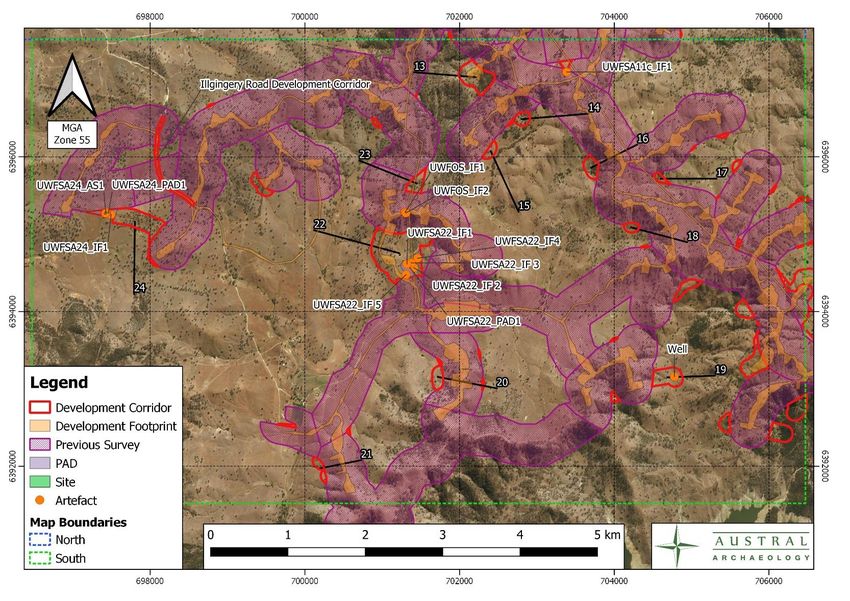
1961- Uungula Wind Farm, Uungula

     Document Information
      Project:                  Uungula Wind Farm, Uungula New South Wales:
                                Aboriginal Archaeological Survey Report (Addendum)

      Services required:        Aboriginal Archaeological Report

      Client:                   CWP Renewables Pty Ltd

      Prepared by:              Neil Fenley

      Project number:           1961

     Document History and Approval Status
      Version                                                      Written     Approved        Date
                 Version Type                       Issue Date
      No.                                                            by           by         Approved

      1          Draft                              21/01/2020        NF       ALA          21/01/2020

      2          Final                             02/03/2020         NF       ALA          02/03/2020

     Distribution of Copies

      Version
      No.        Quantity        Issue date                        Issued to

      1          1               21/01/2020                        CWP Renewables

      Final      1               02/03/2020                        CWP Renewables

     Copyright and Moral Rights
     No part of this document may be reproduced or distributed in any form or by any means
     without prior permission from a representative of Austral Archaeology. Austral
     Archaeology also reserves the right to use documents and materials produced for this
     project for future presentations or publications, if required.

     In the preparation of this report historical sources and other reference materials are
     acknowledged in text citations and in a separate section at the end of the report. Reasonable
     effort has been made to acknowledge and obtain permission from the relevant copyright.

                                                                                        ii | P a g e
1961- Uungula Wind Farm, Uungula

EXECUTIVE SUMMARY
Austral Archaeology (Austral) has been commissioned to prepare an addendum to the Heritage
Impact Assessment (HIA) for the Uungula Wind Farm (the project) for CWP Renewables Pty Ltd
(CWPR). This addendum is required to be complimentary to the Aboriginal Cultural Heritage
Assessment Report (ACHAR) previously prepared by New South Wales Archaeology titled
Uungula Wind Farm Aboriginal Cultural Heritage Assessment Report. Report for Uungula Wind
Farm Pty Ltd (Dibden 2018). The Project is a State Significant Development (SSD 6687) and is
required to meet the standard as set by Secretary Environmental Assessment Requirements
(SEARs) project requirements for the overall project issued on 11 November 2019.
There are three discrete study areas, two adjacent to existing roads, one is situated on Twelve
Mile Road from the corner of Goolma Road in the west to the project entry point in the east, there
is also a short section of Ilgingery Road. The third study area comprises additions to previously
surveyed areas throughout the overall Development Corridor area. The two sections of road were
surveyed 20 metres either side of the existing road. If access was restricted by fencing or other
hazards, general visual observations were made of the inaccessible locations. The surveys
adjacent to the roads is of such a nature that it was possible to survey the entirety of it within a
discrete timeframe, without the necessity to create more manageable unit sizes as outlined in the
current ACHAR. The additional areas, however, were surveyed concentrating on areas of
moderate to high potential as much of the previous survey found little or no artefactual material in
areas of low or no potential. This will complement the existing methodology and not detract from
or alter the previous methodological statement.

Summary of previous Investigations
Archaeological studies across the wider region have identified numerous archaeological sites,
particularly in association with permanent or ephemeral water sources. The sites are almost
entirely made up of single lithic artefacts or scatters of lithic artefacts. These have been extensively
outlined in the previous report and the reader is referred to that for detailed information. However,
Dibden (2018) noted that
    •   Artefacts densities and site complexities are more likely to be greater near reliable water.
    •   That visibility and exposure will greatly influence the detection of artefactual material
    •   There is low potential for artefacts to be present on slopes of moderate to steep gradient.
    •   The presence of grinding grooves is unlikely in the general region as there is an absence
        of suitable rock exposures.
    •   Burials are unlikely to be present, however, the sedimentary deposits near creeks may be
        an exception.
    •   Rockshelters are unlikely as the appropriate geological conditions are not present in the
        overall study area.
    •   Scar trees are unlikely due to the previous clearing of mature trees

Results of archaeological investigations in the study area
The pedestrian survey undertaken as part of the assessment process identified 115 stone artefacts
across 28 new Aboriginal site locations. There were also seven new areas of high and moderate
potential archaeological deposits (PADs) recorded in five of the new survey areas
Based on the quantity and location of the newly identified sites and PADs the Development
Footprint has high potential to impact on Aboriginal objects.

Summary of results
There were eight moderate sized artefact scatters comprised of three artefacts or more, six artefact
scatters of two artefacts and 14 individual finds. The artefacts scatters contained two sites of high
significance UWFSA11_1 and UWFSA11_2, three sites of moderate significance, UWFSA11_3,
UWFSA11_4 and UWFSA24_AS1, a further 22 sites of low significance are detailed in Table 6.

                                                                                             3|Page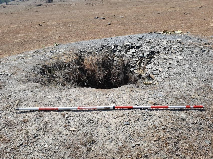
1961- Uungula Wind Farm, Uungula

The sites of high significance include rare and unusual artefacts, the sites of moderate significance
are moderate density artefact scatters, the sites of two artefacts and individual finds are all of low
significance. The newly recorded sites are detailed Table 6, along with their significance.
There were seven areas of PAD located during the survey and these were commonly associated
with watercourses and artefact scatters. These PADs extend beyond the boundaries of the artefact
scatters and will require further investigation if they are to be impacted.

Summary of recommendations
The following recommendations are derived from the survey results and refer to the findings
described in Section 5.1 of this assessment. The recommendations have been developed after
considering the archaeological context, environmental information, consultation with the local
Aboriginal community, and the findings of the survey results and the predicted impact of the
proposed works on archaeological resources.
It is recommended that if it is not possible to realign or reposition certain infrastructure as detailed
in Table 9, Figure 20, Figure 21, Figure 22, Figure 39, Figure 40 and Figure 41 then it will be
necessary to undertake subsurface testing in those areas where impact will affect the
archaeological resources present. This particularly applies to the following areas
    •   Survey Area 11 Which has five artefact scatters and two large PADs, these would be
        directly impacted by the proposed Development Footprint and are within the Development
        Corridor.
    •   Survey Area 24 Has a single artefact scatter and PAD directly in line with the proposed
        Development Footprint and are within the Development Corridor.
    •   Survey Area 6 Has two small artefact scatters and a PAD which would be impacted by
        the proposed Development Footprint and are within the Development Corridor.
Where surface artefacts are located either as individual finds or low density, small artefact scatters
a surface collection of these materials would be appropriate. The subsurface testing and
community collections will need to be undertaken before any construction works are commenced.
Furthermore, the following points should be adhered to before works commence
        1. All contractors undertaking earthworks on site should be briefed on the protection of
           Aboriginal heritage objects under the National Parks & Wildlife Act 1974 (NPW Act)
           and the penalties for damage to these items.
        2. All contractors undertaking earthworks in the study area should undergo an induction
           on identifying Aboriginal heritage objects; and
        3. A copy of this report should be forwarded to all Aboriginal stakeholder groups who
           have registered an interest in the project.

                                                                                             4|Page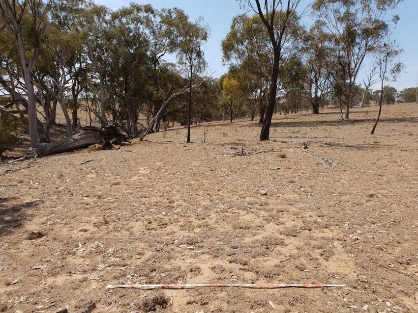
1961- Uungula Wind Farm, Uungula
Contents
EXECUTIVE SUMMARY............................................................................................................ 3
1 INTRODUCTION ................................................................................................................. 8
1.1 Project Description .................................................................................................... 8
1.2 Assessment Objectives ............................................................................................. 8
1.3 Federal and State Legislation ................................................................................... 8
1.4 Section Summary .................................................................................................... 13
1.5 Project Team and Qualifications ............................................................................. 13
1.6 Acknowledgements ................................................................................................. 14
2 ARCHAEOLOGICAL SURVEY ........................................................................................ 16
2.1 Survey Methodology ............................................................................................... 16
2.2 Survey Results ........................................................................................................ 16
3 INDIVIDUAL SURVEY AREAS ........................................................................................ 19
3.1 Twelve Mile Road .................................................................................................... 19
3.2 Ilgingery Road ......................................................................................................... 20
3.3 The Previously Unsurveyed Areas .......................................................................... 21
3.4 Survey Area 1. ........................................................................................................ 22
3.5 Survey Area 2 ......................................................................................................... 23
3.6 Survey Area 3 ......................................................................................................... 25
3.7 Survey Area 4 ......................................................................................................... 26
3.8 Survey Area 5 ......................................................................................................... 27
3.9 Survey Area 6 ......................................................................................................... 28
3.10 Survey Area 7 ......................................................................................................... 30
3.11 Survey Area 8 ......................................................................................................... 31
3.12 Survey Area 9. ........................................................................................................ 31
3.13 Survey Area 10 ....................................................................................................... 33
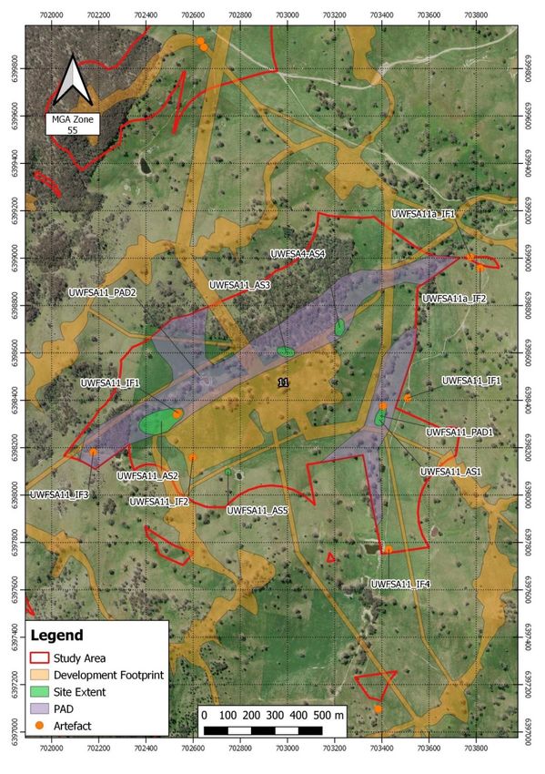
3.14 Survey Area 11 ....................................................................................................... 34
3.15 Survey Area 11a ..................................................................................................... 42
3.16 Survey Area 11b ..................................................................................................... 43
3.17 Survey area 11c ...................................................................................................... 43
3.18 Survey Area 12. ...................................................................................................... 45
3.19 Survey Area 13, 14, 15, 16, 18 and 23 ................................................................... 47
3.20 Survey Area 19 ....................................................................................................... 48
3.21 Survey Area 22 ....................................................................................................... 50
3.22 Survey Area 24 ....................................................................................................... 51
3.23 Individual Finds outside of the survey areas ........................................................... 52
4 ASSESSMENT OF HERITAGE SIGNIFICANCE ............................................................. 53
4.1 Introduction to the Heritage Assessment Process .................................................. 53
4.2 Basis for Assessment of Aboriginal Sites ............................................................... 53
5|Page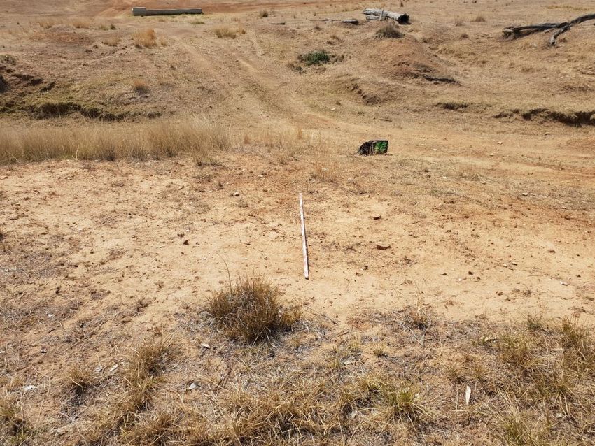
1961- Uungula Wind Farm, Uungula

    4.3         Preliminary Assessment of Aboriginal Sites ........................................................... 54
    4.4         Aboriginal Stakeholder Comments ......................................................................... 61
5     RECOMMENDATIONS ..................................................................................................... 61
    5.1         General.................................................................................................................... 61
6     References ....................................................................................................................... 67
    6.1         Appendix 1 .............................................................................................................. 68

TABLES
Table 1. The Twelve Mile Road and Ilgingery Road survey areas in square metres ................... 17
Table 2. The additional survey areas in square metres as an addendum to the original survey
             .................................................................................................................................. 18
Table 3. Twelve Mile Road and Ilgingery Road survey coverage by landform ............................. 18
Table 4. Additional survey areas coverage by landform ............................................................... 18
Table 5. The location, sensitivity and area of the recorded PADs ................................................ 18
Table 6. The new sites, their locations and their significance ....................................................... 55
Table 7. The impacts and consequences of the proposed works on Artefact Scatters and
            Isolated Finds ............................................................................................................ 63
Table 8. The recommendations for the individual survey areas.................................................... 66

FIGURES
Figure 1. Study area for the Twelve Mile Road Section .................................................................. 9
Figure 2. Northern Section of the Study Area ............................................................................... 10
Figure 3. Southern Section of the study area ................................................................................ 11
Figure 4. Location of UWF12M_AS1, showing typical vegetation on the survey.......................... 19
Figure 5. Two of the artefacts located at UWF12M_AS1. ............................................................. 20
Figure 6. Typical vegetation and ground visibility on Ilgingery Road, facing north. ...................... 21
Figure 7. Survey Area 1 Showing the typical vegetation and visibility .......................................... 22
Figure 8. The deeply incised Mitchell Creek present in the eastern section ................................. 23
Figure 9. One of the backed quartz tools located at UWFSA2_AS1 ............................................ 24
Figure 10. The typical landscape in in Survey Area 3 ................................................................... 25
Figure 11. An example of the large boulders in Survey Area 4 .................................................... 26
Figure 12. The typical landscape of Survey Area 5 ...................................................................... 27
Figure 13. The typical landscape in the western region of Survey Area 6 .................................... 28
Figure 14. The landscape in the region of the two sites in Survey Area 6 .................................... 29
Figure 15. The artefact UWFSA7_1 that was located on the fire trail ........................................... 30
Figure 16. Survey Area 8 showing typical visibility and exposure ................................................ 31
Figure 17. Survey Area 9 showing the typical sloping landform ................................................... 32
Figure 18. The portable grinding located within the site UWFSA11_AS2. .................................... 37
Figure 19. View of UWFSA11_AS3 facing west ........................................................................... 38
Figure 20. The blade core recorded at UWFSA11_AS3. .............................................................. 38

                                                                                                                                    6|Page
1961- Uungula Wind Farm, Uungula

Figure 21. Site UWFSA11_AS4 looking up the gentle rise, facing south ..................................... 39
Figure 22. The backed quartz artefact located within site UWFSA11_AS4 .................................. 40
Figure 23. The location of site UWFSA11_AS5 showing typical visibility and exposure .............. 41
Figure 24. Typical terrain of Survey Area 11a ............................................................................... 42
Figure 25. The quartz outcrop at the western end of Survey Area 11b ........................................ 43
Figure 26. The banded chert manuport located south of survey area 11c. .................................. 44
Figure 27. The typical terrain in the survey area at the location of UWFSA12 1, facing south
             .................................................................................................................................. 45
Figure 28. One of the quartz artefacts recorded at UWFSA12 1 .................................................. 46
Figure 29. Survey Area 13 showing the steep gully common for the hills in this area .................. 47
Figure 30. The second order stream in survey area 19 showing the visibility, facing east ........... 48
Figure 31. The shaft located north of the second order creek in Survey Area 19 ........................ 49
Figure 32. Typical landscape of Survey Area 22 in the southern section ..................................... 50
Figure 33. The site UWFSA24_1 facing north with the second order creek in the background
             .................................................................................................................................. 51
Figure 34. A quartz proximal flake from site UWFSA24_1 ............................................................ 52
Figure 35. Location of the new sites in relation to the proposed works footprint Northern
            Section ...................................................................................................................... 56
Figure 36. Location of the new sites in relation to the proposed works footprint Southern
            Section ...................................................................................................................... 57
Figure 37. Survey Area 11 in detail, showing the overlap of sites, PADs and the development
             footprint ..................................................................................................................... 58
Figure 38. AHIMS sites located within the northern section of the study ...................................... 59
Figure 39. AHIMS sites located within the southern section of the study ..................................... 59
Figure 40. The northern section of the survey area, showing the present survey, previous
            survey and development footprint ............................................................................. 60
Figure 41. The southern section of the survey area, showing the present survey, previous
            survey and development footprint ............................................................................. 60

                                                                                                                                   7|Page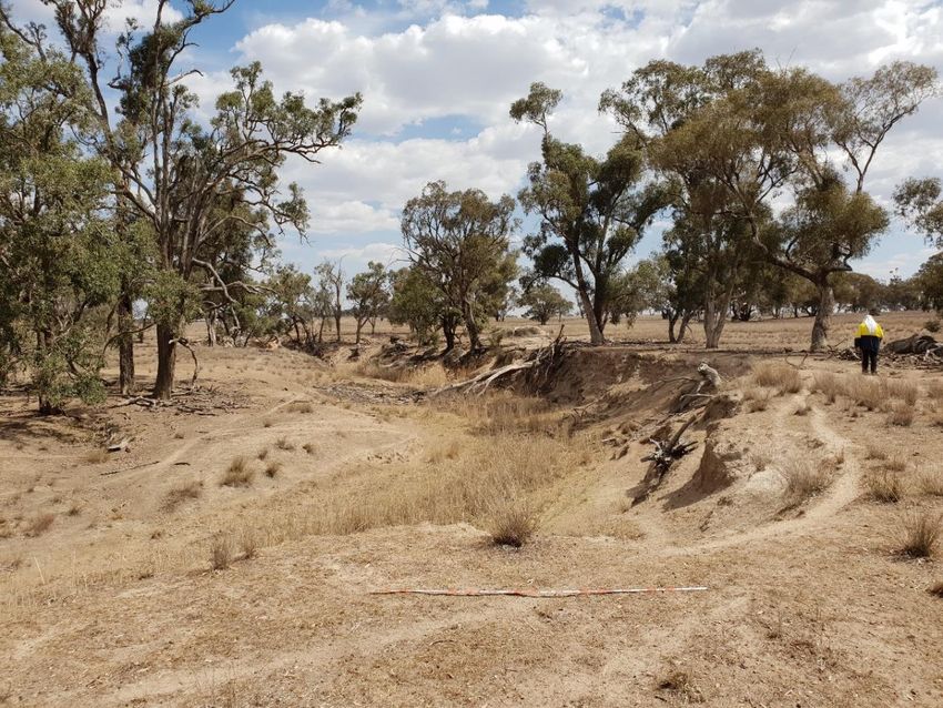
1961- Uungula Wind Farm, Uungula

1     INTRODUCTION
Austral Archaeology Pty Ltd (Austral) has been commissioned by CWP Renewables (CWPR), on
behalf of Uungula Wind Farm Pty Ltd to undertake an addendum Aboriginal Archaeological Survey
Report (AASR) for the Uungula Wind Farm Aboriginal Cultural Heritage Assessment Report 2018
(the previous report). The addendum survey was undertaken from 28 October 2019 through to 1
November 2019 and a secondary follow up survey from 11 December 2019 until 13 December
2019. The study area lies wholly within the Dubbo Regional Council Local Government Area (LGA),
and lies 22 kilometres due east of the township of Welllington, NSW. In December 2019,
Secretary’s Environmental Assessment Requirements (SEARs) were issued and the Department
of Planning and Environment (DP&E) Secretary's Environmental Assessment Requirements (SSD
6687) was issued on 21 December 2016, with a revised SEARs issued on 11 November 2019.
The survey was divided into three distinctive sections. The Twelve Mile Road section has been
subjected to a high level of disturbance during the construction of the existing bitumen road and
associated water dispersal works. The Ilgingery Road section had a moderate level of disturbance
associated with the forming of the gravel road with some water dispersal works. The remainder of
the survey was divided into smaller individual survey areas. Overall, these had been subjected to
a moderate level of disturbance, with some sections containing dams, stockyards and bulldozed
fire trails, all areas had informal farm tracks, stock watering points and evidence of previous
ploughing. The location of the study areas is shown in Figures 1, 2 and 3 below.

1.1       Project Description
The scope of works as been extensively outlined in the previous report (Dibden 2018) and the
reader is referred back to the initial report for further detail. Since that report was prepared further
amendments have been made to the proposed Development Footprint and Study Areas. These
amendments do not affect previous survey or report and only apply to this new AASR. An up to
date map of the Development Footprint was supplied by CWP Renewables on 7 January 2020,
with a further update made available on 18 February 2020 and it is from this mapping that all
assumptions regarding proposed impacts are taken. The Project has revised down the number of
Wind Turbine Generators (WTG) from 109 to 97. This decrease in the number of WTGs will not
affect the results or recommendations of this report.

1.2       Assessment Objectives
The scope of this AASR addendum report is based on the legal requirements, guidelines and
policies of the Heritage Team of the Department of Premier and Cabinet (DPC), formerly the Office
of Environment and Heritage (OEH), and the Department of Environment, Climate Change and
Water (DECCW). The guiding documents for this assessment are the Guide to Investigating,
Assessing and Reporting on Aboriginal Cultural Heritage in NSW (DECCW 2011) [the Guide to
Reporting] and the Code of Practice for Archaeological Investigation of Aboriginal objects in NSW
(DECCW 2010) [the code of practice].
The scope of works includes the following:
      •    Document the results of archaeological survey undertaken in accordance with the code of
           practice.

1.3       Federal and State Legislation
Aboriginal archaeological and cultural heritage assessments in New South Wales are carried out
under the auspices of a range of State and Federal acts, regulations and guidelines. The acts and
regulations allow for the management and protection of Aboriginal places and objects, and the
guidelines set out best practice for community consultation in accordance with the requirements of
the acts. This legislation has been detailed in the previous report and the reader should refer to
this.

                                                                                             8|Page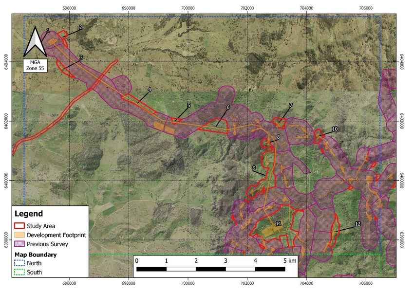
1961- Uungula Wind Farm, Uungula

 Figure 1. Study area for the Twelve Mile Road Section

 Project: 1961
 Operator: William Andrews
 Date:11 March 2020
 Source: Nearmap, NSW Spatial Services

                                                         9|Page
1961- Uungula Wind Farm, Uungula
Figure 2. Northern Section of the Study Area
Project: 1961
Operator: William Andrews
Date:11 March 2020
Source: NSW DFSI Topographic
10 | P a g e1961- Uungula Wind Farm, Uungula
Figure 3. Southern Section of the study area
Project: 1961
Operator: William Andrews
Date:11 March 2020
Source: NSW DFSI Topographic
11 | P a g e1961- Uungula Wind Farm, Uungula
Figure 4. Illgingery Road section of the study area
Project: 1961_Ungula Wind Farm
Operator: William Andrews
Date:11 March 2020
Source: NSW DFSI Topographic
12 | P a g e1961- Uungula Wind Farm, Uungula
1.4 Section Summary
Aboriginal places and objects, both known and unknown, are protected in New South Wales by State
and Federal legislation. The present assessment is being conducted under the DPC's Aboriginal
Cultural Heritage Consultation Requirements for Proponents (2010b) [the Consultation Requirements],
the Guide to Reporting, under Section 80 of the NP&W Regulations and under Part 6 of the NP&W Act
in respect to the identification of Aboriginal stakeholders. As the work is currently classified as a State
Significant Development, the procedures under Part 5 of the EP&A Act do not apply.
Searches of the Australian Heritage Places Inventory (AHPI), the Register of the National Estate (RNE),
the National Heritage List and the NSW Heritage Council’s State Heritage Register (SHR) websites
identified no recorded sites within the study area.
At the State level, the works are to be assessed under the NP&W Act and the EP&A Act. The relevant
sections of the NP&W Act are Section 86, Section 87, Section 89A and Section 90.
1.5 Project Team and Qualifications
This AASR was prepared by Neil Fenley (Archaeologist) and Alexander Beben (Director) and project
management was provided by Amanda Atkinson (Director). William Andrews (Archaeologist) conducted
the GIS mapping. The report was reviewed by Amanda Atkinson (Director) for quality assurance
purposes.
Alexander Beben (B.A. (Hons.) Archaeology, Ma. Archaeology)
Alexander Beben is a Director of Austral Archaeology with over 15 years’ experience in the completion
of historical and Aboriginal heritage projects. Alexander has worked in every state and territory and has
completed in excess of 500 consulting projects. Alexander has extensive experience in the completion
of surveys, excavations and the authorship of archaeological reports and management plans.
Amanda Atkinson (BA. Arch/Paleo, Grad Dip Archaeology)
Amanda Atkinson is an Aboriginal heritage specialist with over 12 years’ experience in Australian
archaeology. Amanda has worked predominantly in eastern Australian states and in Western Australia.
Amanda has extensive experience in Aboriginal consultation and has worked on some of the state’s
most complex Aboriginal heritage projects.
Neil Fenley (B. Arch. (Hons.)
Neil is an archaeologist who has 17 years of experience working throughout Australia on a variety of
projects. He has led large teams on protracted fieldwork projects in remote areas and specialises in
managing large scale fieldwork projects. Neil has also completed numerous Cultural Heritage
Management Reports in Victoria and has recently joined the Austral Archaeology team on a full time
basis.
William Andrews (B.Eng. (Hons) Surveying)
William Andrews is a Graduate Archaeologist for Austral Archaeology. William is a graduate of a
Bachelor of Engineering (Surveying) and has transitioned his career toward Archaeology in 2019. Prior
to his career change William had been working as a land surveyor for two years. Which has given him
the skills to specialise in spatial and technological documentation techniques that relate strongly to
Archaeology. William completed his thesis on these topics and is skilled at photogrammetry, laser
scanning, GIS and in-field documentation methods. William has also studied Archaeology prior to his
engineering degree, which taught him the foundational knowledge required to apply his engineering
abilities to the job.
13 | P a g e1961- Uungula Wind Farm, Uungula
1.6 Acknowledgements
Austral Archaeology would like to acknowledge the participation of the following people who contributed
to the preparation of the report:
• Bradley Bliss Wellington Valley Wiradjuri Aboriginal Corporation
• Helena Stanley Wellington Local Aboriginal Land Council
• Brendan Doherty Gallangabang Aboriginal Corporation
• Fleur Magick Dennis Gallangabang Aboriginal Corporation
• Steven ‘George’ Flick Murong Gialinga
• James Williams Mudgee Local Aboriginal Land Council
14 | P a g e1961- Uungula Wind Farm, Uungula
1.7 Abbreviations
The following are common abbreviations that are used within this report:
ACHA Aboriginal Cultural Heritage Archaeological
AHIMS Aboriginal Heritage Information Management System
AHPI Australian Heritage Places Inventory
AASR Aboriginal Archaeological Survey Report
Austral Austral Archaeology Pty Ltd
COP Code of Practice
CWPR CWP Renewables Pty Ltd
DECCW EP of Environment, Climate Change, and Water
DPC Department of Premier and Cabinet
DP&E Department of Planning and Environment
DPIE Department of Planning Industry and Environment
EP&A Act Environmental Planning and Assessment Act 1979
LGA Local Government Area
NP&W Act National Parks and Wildlife Act 1974
NPWS National Park and Wildlife Service
NSW New South Wales
PAD Potential Archaeological Deposit
SEARs Secretary’s Environmental Assessment Requirements
RNE Register of the National Estate
SHR State Heritage Register
Refer also to the document Heritage Terms and Abbreviations, published by the Heritage Office and
available on the website: http://www.environment.nsw.gov.au/heritage/index.htm
15 | P a g e1961- Uungula Wind Farm, Uungula
2 ARCHAEOLOGICAL SURVEY
2.1 Survey Methodology
The specific survey methodology developed for this assessment was guided by the survey
requirements as set out in the code of practice. The survey methodology was designed to optimise the
investigation of areas where archaeological materials may be present and visible, as well as
investigation of the broader archaeological potential of the study area. The field inspection of the study
area therefore paid close attention to areas of favourable landform conditions.
The key survey variables of ground visibility, which considers the amount of ground surface which is
visible and not covered by any vegetation; and exposure, which defines areas where dispersed surface
soils and vegetative matter afford a clear assessment of the ground, were assessed across the study
area and within each landform element. Overall survey coverage and calculated survey effectiveness
was recorded. Note that the effectiveness of the field survey was largely dependent on the degree of
ground surface visibility.
The individual study areas contained landforms which differed from location to location and were
subjected to differing forms of disturbance. Therefore, each study area was assessed on an individual
basis. The landforms within the Development Corridor were broadly contained to hill crest or hill slope
or alluvial flat, although there were areas of upper and lower terrace (see Table 1). All survey areas
had undergone some form of disturbance, this varied from high, as with the Twelve Mile Road section
to moderate in the majority of the smaller survey areas. Areas of higher surface visibility and inherent
archaeological potential were subject to proportionately closer inspection. In areas of low
archaeological likelihood due to landform or disturbance levels, transects were walked at intervals of
approximately 20 metre distance.
2.2 Survey Results
The archaeological survey of the study area was undertaken 28 October until 1 November 2019 by
Alexander Beben and Neil Fenley of Austral Archaeology, and Bradley Bliss of Wellington Valley
Wiradjuri Aboriginal Corporation, Helena Stanley of Wellington Local Aboriginal Land Council, Brendan
Doherty of Gallangabang Aboriginal Corporation and Fleur Magick Dennis of Gallangabang Aboriginal
Corporation. A further survey was undertaken to clarify these results from 11 December through to 13
December 2020 by Neil Fenley and Hayley Hunter of Austral Archaeology, Steven ‘George’ Flick of
Murong Gialinga and Jamie Williams of the Mudgee Local Aboriginal Land Council.
The visibility and exposure varied greatly across the entire study area, the sections which had been
heavily grazed had visibility up to 90 % while fenced off areas or areas of heavy leaf litter had zero
visibility. The exposure was also highly variable and in some localities was as high as 50 %, generally
though where there were areas of exposure it was from five to ten % (see Table 2). Many of the survey
areas contained ephemeral creek lines and these areas were where the majority of artefacts were
located. Photographs were taken of all survey units and landforms which may provide an indication on
the archaeological potential.
The survey comprised of two distinct components, the first being the Twelve Mile Road and Ilgingery
Road section, the second was the additional survey areas which were required due to a change in the
project scope. The Twelve Mile Road section was 14.23 kilometres in length and was surveyed for 20
metres on either side of the road covering a total area of 569,200 metres squared. The Ilgingery Road
section was 1.45 kilometres in length and this was surveyed for 20 metres either side of the road and
covered 58,000 metres squared (see Table 1).
The additional survey areas encompassed approximately 4,034,534 square metres, however, some of
the survey areas were located on steep slopes and no archaeological potential existed for these areas.
A total of 2,975,616 square metres was surveyed and within these areas, archaeological potential
varied from no potential on the steeper hill slopes and gullies to high potential along the alluvial flats.
The hill slopes and gently undulating hills were the most common landform and accounted for 60.43 %
of the surveyed area, although these were considered to be of low archaeological potential. The alluvial
flats made up a further 22.43 % of the total survey area and areas of these were of high archaeological
potential, therefore, they received the most consideration. Hill crests are an area which is generally
considered to have low archaeological potential and they accounted for 13.10 %, the remainder of the
surveyed areas were lower terrace (2.85 %) and upper terrace (1.14 %) (see Table 2).
16 | P a g e1961- Uungula Wind Farm, Uungula
This survey included multiple survey units of varying sizes and landform elements and within these
there was differing visibility and exposures percentages. Although these figures differed somewhat, to
allow for clarity in assessing the overall survey coverage an average of visibility and exposure per
landform was utilised (see Tables 3 and 4).
There were eight moderate sized artefact scatters comprised of over two artefacts, four artefacts
scatters of two artefacts and 14 individual finds. The survey also recorded seven areas of Potential
Archaeological Deposit (PAD) in four survey areas.
Areas of moderate or high archaeological potential were limited to the alluvial flats and artefact scatters
on the surface were indicative that these areas have high potential to contain sub-surface deposits. The
other landforms present such as hill slopes were not conducive to or suggestive of areas of moderate
archaeological potential. The location of surface artefacts is generally concentrated in the region of
higher order creek lines. However, some artefacts were recorded on hill crests and as there was only
skeletal soils overlying areas of exposed bedrock no PAD was present. Table 5 outlines the areas of
PAD and their location within the survey areas
Survey Area Flat ground to gently undulating m2
Twelve Mile Road 569,200
Ilgingery Road 58,000
Total 627,200
Table 1. The Twelve Mile Road and Ilgingery Road survey areas in square metres
Survey Upper Lower Alluvial Flat Crest m2 Slope m2 Total m2
Area Terrace m2 Terrace m2 m2
1 19,886 19,886
2 14,358 61,456 75,814
3 73,463 14,470 87,833
4 133,405 60,148 193,553
5 37,376 37,376
6 139,341 172,350 311691
7 14,182 91,951 106133
8 5,007 72,057 77064
9 88,855 88,855 482.967 178193
10 14,182 91,849 106031
11 404,535 817,465 1222000
11a 3,627 3,627
11b 12,200 12,200
11c 11,300 11,300
17 | P a g e1961- Uungula Wind Farm, Uungula
Survey Upper Lower Alluvial Flat Crest m2 Slope m2 Total m2
Area Terrace m2 Terrace m2 m2
22 34,902 21,293 311,599 367794
24 24,036 39,626 101,459 165,121
Total 34,244 85492 667633 390013 1798334 2,975,616
Table 2 The additional survey areas in square metres as an addendum to the original survey
Landform Element Landform Visibility Exposure % Effective % of landform
Area (sq m) % Coverage effectively surveyed (=
Area (sq m) area effectively
(area x vis surveyed/ landform x
5% x exp%) 100)
Flat to gently undulating 627,200 30 20 37,623 6.0%
Table 3 Twelve Mile Road and Ilgingery Road survey coverage by landform
Landform Element Landform Visibility Exposure % Effective % of landform
Area (sq m) % Coverage effectively surveyed (=
Area (sq m) area effectively
(area x vis surveyed/ landform x
5% x exp%) 100)
Slopes 1,798,333 50 20 179,833 10.0%
Alluvial Flats 667,633 60 20 80,115 12.0%
Crests 390,013 40 10 15,600 38.46%
Lower Terrace 85,492 80 60 41,036 48.23
Upper Terrace 34,244 20 10 644 1.87
Total area 2,975,616 N/A N/A 317,228 10.65
Table 4 Additional survey areas coverage by landform
Survey Area PAD sensitivity PAD area in m2
2 Two PADs High 34,398
6 One PAD Moderate 2,9389
11 Two PADs High 365,346
22 One PAD Moderate 41,933
24 One PAD High 22,850
Total 493,916
Table 5 The location, sensitivity and area of the recorded PADs
18 | P a g e1961- Uungula Wind Farm, Uungula
3 INDIVIDUAL SURVEY AREAS
3.1 Twelve Mile Road
This survey was conducted along Twelve Mile Road within the fence line 20 metres either side of the
bitumen road. The survey began at the corner of Goolma Road and Twelve Mile Road heading in an
easterly direction for 14.5 kilometres. The landform was flat ground slightly rising to the east near the
Goolma Road intersection gradually changing to very low rolling hills incised by deep creek lines.
Vegetation varied along the course of the survey with tree clearing and heavy stock grazing throughout.
Trees present included white box (Eucalyptus albens), sheoak (Allocasuarina sp.) and kurrajong
(Brachychiton populneus) with small shrubs and grasses located in areas less heavily grazed. A high
level of disturbance was present from the construction of Twelve Mile Road and the associated water
run offs. Visibility and exposure along the survey route varied, dependent on clearing and grazing,
however, it was determined that overall there was an average of 20 % visibility and 10 % exposure over
the survey area.
There were three sites located within this study area, UWFTMR_IF1 a single basalt multi-platform core,
UWF1TMR_IF2 a chert flake with clear negative flake scars and UWFTMR_AS1, three flakes in close
proximity to each other. The overall archaeological potential for the entirety of the Twelve Mile Road
survey area was considered to be low, due mainly to the level of disturbance which has occurred during
the construction of the road and ongoing maintenance.
Figure 4. Location of UWF12M_AS1, showing typical vegetation on the survey
19 | P a g e1961- Uungula Wind Farm, Uungula
Figure 5. Two of the artefacts located at UWF12M_AS1.
3.2 Ilgingery Road
The Ilgingery Road area was surveyed for approximately 1.5 kilometres on 20 metres either side of the
bitumen road. This area was in gently undulating hills on a winding road. Mature white box trees were
sparsely located with dense immature eucalypts in the northern region, pasture and native grass was
present although this was also sparse. A high level of disturbance has taken place from the construction
and improvements to Ilgingery Road, this disturbance was noted as far as 20 metres from the road.
Visibility in this area averaged 50 % and exposure was 20 %. The area adjacent to the previously
identified site SU86/L1 was intensively surveyed to establish whether it encroached into the study area.
No cultural material was located near this site and no cultural material was located within this survey
unit. The area surveyed was determined to be of low archaeological potential.
20 | P a g e1961- Uungula Wind Farm, Uungula
Figure 6. Typical vegetation and ground visibility on Ilgingery Road, facing north.
3.3 The Previously Unsurveyed Areas
These survey areas were an addendum to the previous survey undertaken; this was required due to a
change in the Development Footprint and Development Corridor. Many of these additional areas where
relatively small in size being under 500,000 square metres. Access to these areas was often difficult
and in some cases they were not accessible by vehicle, therefore, these areas were accessed by foot.
Not all of the survey areas were accessed as some of the landforms, such as the steep slopes and
deep gullies had no archaeological potential. However, other landforms with moderate to high
archaeological potential were intensively surveyed, such as the alluvial flats adjacent to creek lines.
This was discussed with the Aboriginal representatives present on the survey and agreed between both
parties.
The vegetation present across the entirety of the survey areas has undergone large scale tree clearing
in the past. The ploughing of paddocks for pasture grass, informal tracks and stock have also caused
disturbance and it is reasonable to suggest moderate disturbance exists throughout the area. The
sowing of pasture grass generally resulted in visibility being reduced to as low as 20 %, however, some
of the survey areas had been intensively grazed meaning visibility was as high as 90 %.
The results of this survey are in keeping with the regional predictive model, in that sites are most likely
to be located near creek lines with low density small scatters present throughout the landscape.
21 | P a g e1961- Uungula Wind Farm, Uungula
3.4 Survey Area 1.
This study area was roughly parallelogram in shape and covered 19,886 metres square. The landform
was a relatively flat lower terrace white sparse white box and pasture grass. The area had undergone
disturbance from fencing, power line installation and informal tracks. The visibility at this location was
60 % with the exposure on the crest 40 % and the slope 30 %. There was no artefactual material
recorded for this location and the archaeological sensitivity was low. There are no proposed impacts in
this survey area.
Figure 7. Survey Area 1 Showing the typical vegetation and visibility
22 | P a g e1961- Uungula Wind Farm, Uungula
3.5 Survey Area 2
This irregular shaped polygon measured 75,814 square metres in total and contained two landforms.
The upper terrace landform was 14,358 square metres and made up 19 % of the total area, the lower
terrace was 61,456 metres square and accounted for the remaining 81 % of the area. The lower terrace
area was in parts bordered by the deeply incised Mitchell Creek in the east. The vegetation was limited
to mature white box and pasture grass. The dense pasture grass in the upper terrace area limited
visibility to 10 % and exposure was confined to the stock pads at five %. However, the lower terrace
had 80 % visibility and 60 % exposure. There were four artefacts located in the northern section on the
crest of a hill within this survey unit and one just outside the survey boundary. The site UWFSA2_AS1
was comprised of three basalt and two crystal quartz artefacts, both the crystal quartz artefacts showed
evidence of retouch and are therefore classified as tools. The presence of a site at this location infers
there is a high archaeological potential in this location. There is a small area in the south east of the
study area which the proposed activity footprint impacts, however this in an area of low archaeological
potential.
Figure 8. The deeply incised Mitchell Creek present in the eastern section
23 | P a g e1961- Uungula Wind Farm, Uungula
Figure 9. One of the backed quartz tools located at UWFSA2_AS1
24 | P a g e1961- Uungula Wind Farm, Uungula
3.6 Survey Area 3
The survey area is semi-circular in shape and encompasses two distinct landforms over 87,833 square
metres and is made up of hill crest measuring 73,463 square metres and hill slope at 14,470 square
metres This survey area had very sparse white box and was essentially cleared for pasture grass.
Disturbance was limited to stock pads, informal tracks and fencing. There was no archaeological
material recorded in this survey area on either landform and the archaeological potential for this entire
survey area was considered to be low. The proposed works footprint runs through the northern section
of the study area in an area of low archaeological potential.
Figure 10. The typical landscape in in Survey Area 3
25 | P a g e1961- Uungula Wind Farm, Uungula
3.7 Survey Area 4
This area was basically rectangular in shape and covered a total of 194,522 metres square, with
144,382 metres being hill crest and the remainder slope. Large granite boulders were present and were
the dominant feature of this in this area. Mature white box and immature eucalypts were scattered
sparsely throughout with pasture grasses. The disturbances were primarily informal tracks and fencing
with some stock related erosion along the stock pads. The visibility was quite high at 40 % and the
exposure very high at 60 %. No artefactual material was located during the survey and the area was
considered to be of low archaeological potential. The area will be impacted by the development across
the entire southern section, although this region is of low archaeological potential.
Figure 11. An example of the large boulders in Survey Area 4
26 | P a g e1961- Uungula Wind Farm, Uungula
3.8 Survey Area 5
This small triangular shaped area measured 37,376 metres squared and was entirely a gentle sloping
landform, with granite boulders eroding out of the soils. There are very sparse white box present,
immature eucalypts, native poa species. and pasture grass present across the survey area. There has
been little recent disturbance aside from the informal vehicle tracks and stock pads. Visibility was 50 %
and the exposure 30 %, although it was variable across the area. There were no artefacts recorded in
the is survey area and the archaeological potential was determined to be low. This survey area is
bisected by the proposed Development Footprint, however, it is in an area of low archaeological
potential.
Figure 12. The typical landscape of Survey Area 5
27 | P a g e1961- Uungula Wind Farm, Uungula
3.9 Survey Area 6
This irregular shaped polygon is 311,691 square metres in total and is made up of two landforms. The
alluvial flat in the western area was 139,341 metres square and the eastern, sloping landform with
granite boulders exposed across the area made up the remaining 172,350 metres square. There is a
deeply incised first order creek situated on a sloping landform running in a west-east direction through
the center of the survey area. The vegetation present includes immature eucalypt species and aloe
casuarina with pasture grass present throughout. Visibility varied throughout the landforms, however,
the alluvial flat had 80 % and 10 % exposure while the sloping landform was 40 % visibility and had 40
% exposure. This survey area had two sites each with two artefacts located on a gentle slope within 30
metres of creek line. The site, UWFSA6_AS1 is the more centrally located within the survey area and
contains one quartz and one basalt artefact and UWFSA6_AS2, to the east is also comprised of one
quartz and one basalt artefact. The archaeological potential for the survey area in general was low,
however, UWFSA6_PAD1 which encompasses the two sites and extends for the length of the
watercourse in an east-west direction has moderate archaeological potential. The proposed works
footprint will directly impact the two sites and the PAD.
Figure 13. The typical landscape in the western region of Survey Area 6
28 | P a g e1961- Uungula Wind Farm, Uungula
Figure 14. The landscape in the region of the two sites in Survey Area 6
29 | P a g e1961- Uungula Wind Farm, Uungula
3.10 Survey Area 7
Survey area 7 was an irregular shaped polygon of 106,133 square metres with an area of hill crest of
14,182 square metres and the remaining 91,951 square metres being steep slope. The landform
leading from the ridgeline which had short spurs running out from the main ridge varied in slope although
this was up to 30 degrees in places. Vegetation consisted of small eucalypt sp., kurrajong and sparse
sheoak, some small shrubs including grass trees (Xantharrea spp.) along with grasses on the minor,
cleared spurs. The ridgeline previously had a fire trail constructed along it and the visibility along this
was high at 70 %, while elsewhere it was ten %. It was determined an average of 20 % visibility over
the survey area was appropriate with exposure at five %, this being restricted to the fire trail. The down
slopes were heavily wooded and completely covered in leaf litter. A single isolated
artefact UWFSA7_1, a complete basalt flake with flaked platform and feather termination was located
on the fire trail. The archaeological potential for this area was low. The proposed development footprint
will directly impact this artefact.
Figure 15. The artefact UWFSA7_1 that was located on the fire trail
30 | P a g e1961- Uungula Wind Farm, Uungula
3.11 Survey Area 8
This small semi circular shaped polygon is 81,392 metres squared in total and contains two landforms,
the lower slope is 72,057 metres squared and the crest of a low hill makes up the remaining 5,007
square metres. The vegetation present in this area included widely dispersed mature white box,
immature eucalypts and pasture grasses. The disturbances were confined to informal tracks and stock
pads and the visibility and exposure for the entire area were both 40 %. There was no archaeological
material recorded in this survey area and the archaeological potential was considered low. The central
section of the survey area will be impacted by the Development Footprint, however, the entire survey
area is of low archaeological potential.
Figure 16. Survey Area 8 showing typical visibility and exposure
3.12 Survey Area 9.
This large irregular shaped polygon was 648210 metres squared and contained three different
landforms. The gently sloping landform was 482.967 square metres in size and was separated by an
alluvial flat which was 88,855 metres square, while at the southern end a crest line was 76,385 metres
squared. The vegetation in the gently sloping country was sparse, restricted to pasture grass with the
occasional eucalypt restricted mostly to the east, there were some mature eucalypts along the drainage
line in the alluvial flat and a dense stand of eucalypt on the crest in the southern section. The
headwaters of Wuuluman Creek pass through this survey area and the banks of this named waterway
were more intensively surveyed. The visibility and exposure across the lower slope and alluvial flat was
relatively constant at 40 % for each, however the crest had a visibility of 10 % and an exposure of 5 %.
There were two artefacts, a chalcedony retouched flake and a retouched basalt flake. located in the
southern section and as they were within 25 metres of each other they were placed together as site
UWFSA9_AS1, this site was located 70m to the south of Wuuluman Creek. The archaeological potential
of the survey area was only considered to be low, generally a named waterway would be indicative of
an area of high archaeological potential, however, as this is the headwaters it corresponds more closely
with a first order stream. The survey area will be partially impacted over the entire area and the site
location will be directly impacted by the proposed works.
31 | P a g e1961- Uungula Wind Farm, Uungula
Figure 17. Survey Area 9 showing the typical sloping landform
32 | P a g e1961- Uungula Wind Farm, Uungula
3.13 Survey Area 10
Survey area 10 was a small irregular shaped polygon measuring 97,210 metres squared in heavily
wooded steep terrain and access to this area was gained along a rough fire trail along a narrow ridge
line. The crest line comprised 14,408 square metres of this survey area with the remaining 82,812
square metres being steep slope of 30 degrees or greater in most locations. Vegetation was
predominately eucalypt species, with sparse kurrajong and sheoak present. Some areas
of small shrubs were present, however, grasses were not, except at the base of the ridgeline.
Disturbance in this area was restricted to the bulldozed fire trail leading up to the ridgeline. Visibility
was high along the fire trail, 70 % but due to the high degree of leaf litter and fallen trees less than 5 %
elsewhere while exposure was limited to the bulldozed fire trail or bedrock. There was no cultural
material present along the survey route and due to the steep terrain, there was no archaeological
potential for this area. The proposed development will directly impact the central region of the survey
area.
Figure 18. Survey Area 10 showing the fire trail leading up to the ridgeline, facing north.
33 | P a g e1961- Uungula Wind Farm, Uungula
3.14 Survey Area 11
This large survey area covered 1,222,000 metres squared metres in a roughly trapezoid shape. There
were various landforms including ephemeral creek lines with associated alluvial flats (404,535 square
metres), leading up to gentle slopes (817,465 square metres) and low rolling hills. The survey initially
covered all landforms, however, it was determined that a more productive strategy would be to
concentrate on the landforms with a moderate to high sensitivity. Therefore, the areas adjacent the first
and second order streams were intensively surveyed. This survey area contained outcrops of quartz or
basalt which may have been utilised as a raw material source and these were also more intensively
surveyed.
Vegetation varied depending on the landform, on the gentle slopes and low rolling hills sparse white
box with pasture grass dominated, whereas along the creek large eucalypts were present. In the
western section, Blackberry had overtaken the low ground where a swamp would have once existed,
the Blackberries were within a dense scrubby area which had thick leaf litter meaning there was poor
visibility. The survey area had also been heavily grazed in some parts and lightly in others. This grazing
had created some areas of bulldust which reduced visibility substantially.
The disturbance in Survey Area 11 was moderate across the entire area and consisted of informal
tracks, some minor earthworks at creek crossings, construction of dams and stock trampling near
gates. The visibility over the area varied from 80 % to zero, however, and overall visibility of 40 % was
considered correct. Exposure also varied, the creek banks generally had 30 % exposure from the action
of stock, while the gentle slopes were as low as 5 %, overall though there was an exposure of 10 %.
Two large areas of PAD where present along the two water courses, these PADs are on alluvial soils
which have the potential to have deep deposits which may have a degree of stratification. A total of four
artefact scatters and five sites made up of single artefacts sites were recorded in Survey Area 11.
Artefact Scatter 1 (UWFSA11_AS1)
The site is located adjacent to a second order creek bank and is 80 metres long and 20 metres wide. It
is a low-density scatter with two concentrations separated by approximately 25 metres. The vegetation
associated with this site included the large, mature eucalyptus species on the creek bank and sown
pasture grass. Ploughing to sow pasture grass is the main disturbance, however, the erosion of the
creek banks by stock trampling and flooding events suggests that a moderate level of disturbance is
occurring to the site. The visibility at this location is 30 % and an exposure of 20 % was limited to the
eroded creek bank. There was a total of 19 artefacts recorded including two portable sandstone grinding
grooves and a partially prepared axe blank, quartz bi polar cores and quartz flakes, basalt flakes, chert
flakes and a crystal quartz proximal flake. The axe blank and one of the portable grinding grooves were
located halfway between the creek bed and the top of the bank. It was apparent that artefacts are
eroding out of the creek bank and dropping towards the creek bed. The archaeological potential for this
site is high and there is a UWFSA11_PAD1 running the entire length of the creekline. The site is within
20 metres of the proposed development footprint to the south and 40 metres to the east.
34 | P a g eYou can also read