Stonnington Cycling Strategy 2013-2018 - DRAFT December 2013
←
→
Page content transcription
If your browser does not render page correctly, please read the page content below
Stonnington Cycling Strategy
         2013-2018

          December 2013
            DRAFT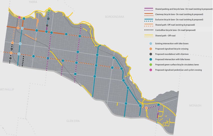
Stonnington Cycling Strategy 2013-2018                                                                                                    draft

Table of contents

1      Introduction ......................................................................................................................... 1
2      Background .......................................................................................................................... 4
    2.1       Providers of cycling in Stonnington ........................................................................................ 7
3      Key factors informing the Cycling Strategy........................................................................... 10
    3.1    Policy context ........................................................................................................................ 10
    3.2    Participation trends and other drivers of participation ........................................................ 12
      3.2.1 Travel patterns and behaviours ........................................................................................ 12
      3.2.2 Cycling related incidents and accidents............................................................................ 16
    3.3    Community profile and population change .......................................................................... 17
    3.4    Land use and development ................................................................................................... 18
    3.5    Appraisal of the cycling network .......................................................................................... 20
      3.5.1 Trail network audits.......................................................................................................... 21
4      Key issues and directions .................................................................................................... 22
5      Opportunities for cycling..................................................................................................... 22
    5.1       Supporting access to activity centres ................................................................................... 23
    5.2       Supporting access to education ............................................................................................ 24
    5.3       Supporting access to green open space................................................................................ 25
    5.4       Supporting access to rail services ......................................................................................... 26
6      The Cycling Strategy Framework ......................................................................................... 27
    6.1       The Strategy Framework ....................................................................................................... 27
7      Application of the Framework – actions and implementation plan ....................................... 29
    7.1    Summary of key actions ........................................................................................................ 30
    7.2    Delivering the Strategy ......................................................................................................... 31
    7.3    Monitoring implementation of the Strategy ........................................................................ 34
      7.3.1 Reporting .......................................................................................................................... 35

     Acknowledgements:
     Two key background documents have informed and support the Strategy. These include:
          •   Cycling Discussion Paper, CDM Research (March 2012), and
          •   A New Future for Cycling in Stonnington 2013-2023 and Beyond, GHD (April 2013)

December 2013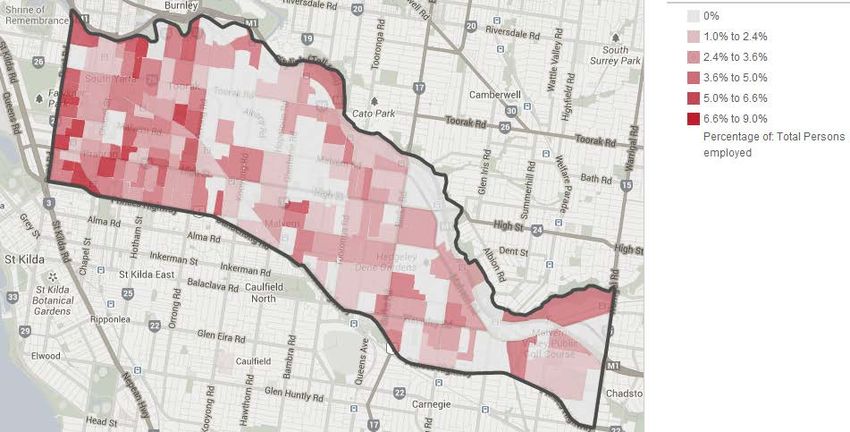
Stonnington Cycling Strategy 2013-2018                                                                draft

Executive Summary
Vision for cycling
Council’s vision for cycling in Stonnington is that;
    Cycling will be widely undertaken in Stonnington, whether for fun, fitness or travel –
    providing health, economic, social and environmental benefits to the community.
    Participation will be encouraged by facilities, programs and services.

     Travel throughout Stonnington by bicycle will be easy and safe, supported by a
     comprehensive network of accessible and convenient paths, laneways and trails that are
     accompanied by facilities that provide for resting and storing / securing bicycles. It will be
     particularly easy to access local facilities and gathering places.

Cycling is an activity commonly undertaken by people of all ages and levels of ability. People
undertake cycling for a range of purposes and benefits, including; sport (eg. various forms of road
racing, mountain bike riding), fitness, recreational enjoyment or as a form of transportation (eg. riding
to work / school). The majority of cyclists fit within the latter two categories of cyclists (ie. recreational
riders and commuters).

The Stonnington Cycling Strategy 2013-2018 aims to enhance the physical and social environments
in order to support more people to cycle, and people to cycle more often. The Strategy addresses all
cycling facilities in Stonnington, including trails, shared paths, on road bike lanes and associated
infrastructure (such as signage, resting places and parking facilities), as well as programs and
services to promote and encourage participation. In particular, the Strategy focuses on ensuring good
access to key local destinations, such as shopping, education, recreation and employment locations.
Two background documents have informed and support the Strategy. These include, the Cycling
Discussion Paper, CDM Research (March 2012), and A New Future for Cycling in Stonnington 2013-
2023 and Beyond, GHD (April 2013).

The strategic framework
The strategic framework used for determining Council’s priorities for cycling improvements has been
informed by the current key issues facing the development of cycling, including a review of current
cycling conditions and community trends.

                             Intra-
                                                                            Social
                           personal
                            factors
                                                      Strategic            factors
                                                     directions

                                          Activity            Green
                                          centres        V    open
                                                              space
                                                         I
                                         Strategic       S    Strategic
                                             goals            goals
                                                         I
                                           Rail          O
                                                             Education
                                         stations        N

                                                      Strategic
                           Physical                  directions            Policy &
                         environment                                      regulation

December 2013                                                                                     Page |i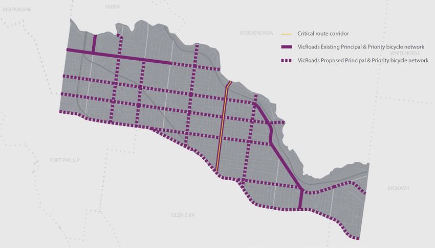
Stonnington Cycling Strategy 2013-2018                                                            draft

Strategic goals
In achieving its vision for cycling, Council aims to:
  •   Increase participation in cycling to influence positive health and social benefits to the
      community, and environmental benefits to the City.
  •   Influence the development of a safe cycling environment through encouraging greater
      awareness and tolerance between cyclists, motorists and pedestrians.
  •   Create conditions (physical, social and motivational) to overcome individual and social barriers
      to cycling, to support people make the decision to cycle;
  •   Develop, facilitate, promote and deliver initiatives that provide opportunities for people to
      develop their skills and confidence in cycling; and to
  •   Reduce travel by vehicle for short local trips made by residents to help alleviate road
      congestion and provide environmental benefits to the City.

Strategic directions
Five strategic directions capture the intent of the Vision and Goals and address the key issues
impacting on the development of cycling in Stonnington. They guide the development of actions to
improve conditions for cycling in accordance with the strategic framework. The strategies are:
  •   Encourage participation in cycling through promoting and marketing cycling broadly, and
      advocating for the development of cycling in Stonnington. Specifically consider the needs of
      groups that have lower participation rates (such as women, families, children, older adults,
      culturally and linguistically diverse communities and lower socio-economic groups) to increase
      their participation.
  •   Facilitate the development of safe, accessible, legible, functional and appropriate cycling
      options and initiatives to encourage participation in cycling and a culture of sharing space.
  •   Continue to develop and improve the cycling network and associated facilities to provide
      access to local places of congregation and prioritising the VicRoads designated Priority Bicycle
      Corridors.
  •   Support people at their destinations through enhancing the end-of-trip experience.
  •   Champion the creation of a thriving and diverse local cycling culture in Stonnington.

Strategic approach
The strategic framework is based on the physical, social, individual and political factors that combine
to influence a person’s decision to cycle. These elements are described, and the inter-relationship
between them is illustrated following:

December 2013                                                                                 P a g e | ii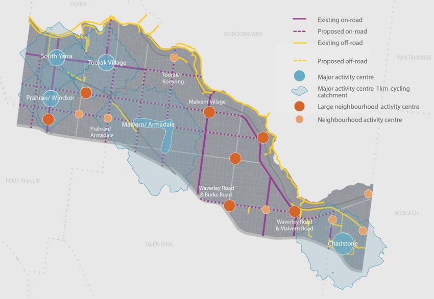
Stonnington Cycling Strategy 2013-2018                                                                         draft

         Factors that are specific to us as                                 Factors specific to societies (eg. the
      individuals (eg. our self-confidence in                                 influence of friends, family and
           our ability to ride a bicycle)                                               colleagues)

      The built and natural environment (eg.                                 The influence of wider government
          bicycle routes and end-of-trip                                    policy and regulation (eg. enforcement
                     facilities)                                                         of road rules)

Source: A New Future for Cycling in Stonnington 2013-2023 and Beyond, GHD

This Strategy provides the blueprint to guide Council in achieving the Vision for cycling, as shaped by
the Strategic goals and Strategic directions, and influenced by the four behavioural elements.

The basis of the Strategy is to provide the conditions that encourage residents to cycle as an
everyday or normalised activity. As such, short local trips based around key places of congregation
are the focus, including; activity centres, education, green open space and rail stations. This is not to
the exclusion of broader travel by bicycle to destinations outside of Stonnington, which will
complement the successful functionality of the ‘internal’ network.

Cycling in Stonnington
The existing ‘designated’ cycling network in Stonnington covers approximately 22 kilometres of off-
road trails, and 29 kilometres of on-road bicycle lanes (not including kilometres of other streets also
used by cyclists not formally designated as cycling routes) providing a range of opportunities to cycle
within and through the City.

December 2013                                                                                          P a g e | iii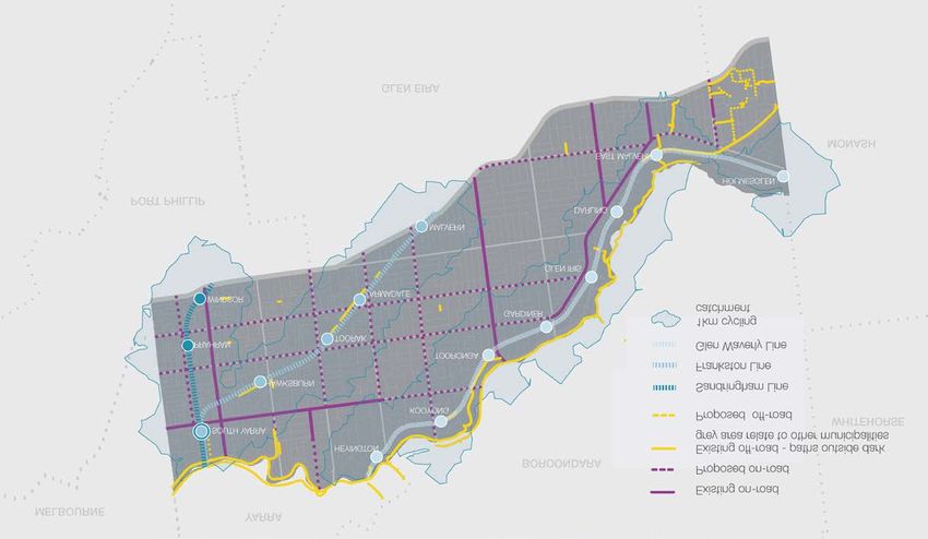
Stonnington Cycling Strategy 2013-2018                                          draft
Existing on-road and off-road Stonnington cycle network

Source: A New Future for Cycling in Stonnington 2013-2023 and Beyond, GHD

December 2013                                                               P a g e | iv
Stonnington Cycling Strategy 2013-2018                                                            draft

Cycling in Stonnington is provided via a range of avenues by various stakeholders, including:
  •   Shared trails (off-road); paths and trails shared between cyclists and pedestrians in parks and
      open spaces. The main off-road trails in Stonnington are; Capital City Trail and Main Yarra
      Trail (running along the Yarra River), the Gardiner’s Creek Trail (running along Gardiner’s
      Creek and providing a critical connection to the Capital City Trail), and the Scotchman’s Creek
      Trail.
      This infrastructure is primarily the responsibility of Council (where Council is owner of the land).
  •   On-road bike lanes; exclusive bike lanes, clearway bike lanes, shared car parking and bicycle
      lanes, and bicycle headstart (storage) boxes.
      Council and VicRoads are the key organisations responsible for infrastructure on roads, with
      VicRoads having responsibility for many of the major roads in Stonnington;
  •   Ancillary infrastructure; such as signage (regulatory, warning, guidance), parking facilities and
      storage boxes.
      Responsibility for these items rests with the authority responsible for the road infrastructure
      which will be either Council or VicRoads;
  •   Programs and services, such as riding tuition, cycling adventures and events, maps and
      information.
      Council is one of a number of service providers, including community groups and community
      organisations; and
  •   Promotion and information – this is provided by Council, other agencies, community groups and
      businesses.

The City of Stonnington is one of a few key stakeholders with a role in planning, providing, managing
and promoting cycling opportunities in Stonnington. There are a number of other partners relevant to
the provision of cycling opportunities. These include; the Stonnington community, schools and
community groups; State government; neighbouring councils; Bicycle Network Victoria, and other
working groups and networks (such as the Road Safety Action Group of inner Melbourne councils),
and the Inner Melbourne Action Plan (IMAP). Council works with all of these partners and
stakeholders (as relevant) when improving opportunities for cycling.

Within Council, cycling is a cross-departmental responsibility requiring multiple departments to work
together to ensure that cycling initiatives are planned for and developed in a coordinated way. Overall
coordination of Council’s activities in cycling provision is undertaken by the Sustainable Transport
Planner.

As the custodian of many roads in Stonnington, the State Government (through VicRoads) is
responsible for the development of cycling infrastructure on these roads. VicRoads categorises
cycling pathways according to a hierarchy of roads, and has a program for implementing cycling
infrastructure improvements. Council advocates to VicRoads regarding cycling infrastructure priorities
and applies for infrastructure projects to be funded, but the priority and implementation of these
projects is ultimately at the discretion of VicRoads and its funding parameters.

Key issues relevant to cycling in Stonnington
Key issues identified through the background research that have informed the directions of the
Strategy include:
  •   Participation - There are many benefits to be gained through building on the increasing rates
      of cycling participation – for individuals and the community. To grow participation further,
      cycling facilities, programs and services need to be safe, appealing, easy to access and

December 2013                                                                                 Page |v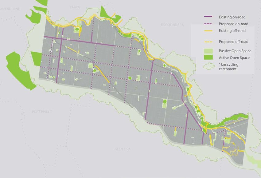
Stonnington Cycling Strategy 2013-2018 draft
appropriately targeted. There is an opportunity to focus on particular target groups to
encourage participation in cycling, especially those that have lower levels of participation (such
as females, who have a significantly lower participation rate than males).
• Physical layout and accessibility - There are benefits and constraints for cycling associated
with the urban form of Stonnington. In particular, the medium to high density style of residential
living and close proximity of key services is a characteristic that supports travel by bicycle; the
layout of the road network in Stonnington provides for permeable travel north-south and east-
west, and the large amounts of linear open space provide opportunities for corridors that
support bicycle travel, make the City easy to access by bike. However the narrowness of
roads, and heavy traffic, makes on-road provision for cycling challenging. Regardless of these
challenges, opportunities to facilitate local bicycle travel need to be pursued.
• Optimising existing infrastructure - There is already an extensive network of cycling trails
(on and off road). This system should be regarded as the foundation for the cycling system,
and projects that address the connections, missing links, maintenance and other infrastructure
needs of these facilities should be prioritised.
• Shared use of space - Safety is a paramount consideration in the planning, design,
construction and management of cycling infrastructure, given the high levels of use of parks
and roads by vehicles, trams, pedestrians, as well as cyclists. There is a need to influence a
culture of sharing, so as to create as safe an environment as possible for all users, and attempt
to reduce the potential for conflict.
• Partnerships - As Council is not the only stakeholder responsible for cycling provision, it must
work in partnership with other key stakeholders (such as the community, Metro Trains, Police,
traders), but particularly VicRoads. This requires alignment of priorities and funding for projects
which are often led by VicRoads. There is an opportunity to work towards strengthening this
partnership by Council taking a more active role in the foundation planning of VicRoads
projects to establish a sound business case to advocate strongly for improvement works to be
funded.
• Resourcing – Council’s resourcing of cycling has supported the delivery of a range of
infrastructural and behavioural initiatives. The distribution of responsibility for cycling across
multiple work areas at Council requires inter-departmental coordination to ensure integration
and consistency in the delivery of cycling initiatives. A cross-departmental working group has
been convened to ensure this coordination is achieved to optimise outcomes. The opportunity
exists for the working group to continue to work together on implementation of the Cycling
Strategy actions.
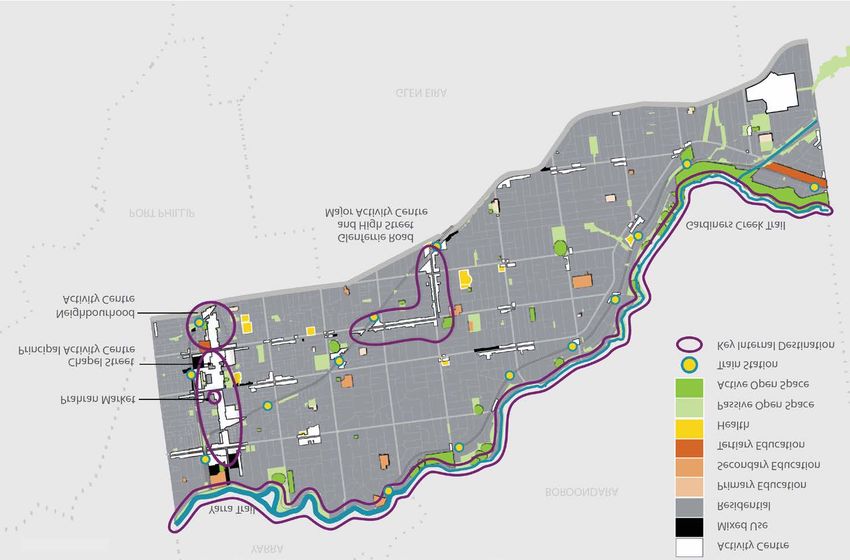
The Stonnington cycling network – towards the future
The following map illustrates the aspirational cycling network in the City of Stonnington, which brings
the vision and goals to life. The envisioned network addresses all desired links and connections
within a five year lifespan.
December 2013 P a g e | vi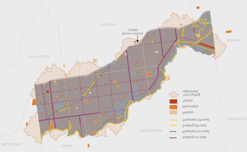
Stonnington Cycling Strategy 2013-2018                                           draft
Five-year aspirational Stonnington cycle network

Source: A New Future for Cycling in Stonnington 2013-2023 and Beyond, GHD

December 2013                                                               P a g e | vii
Stonnington Cycling Strategy 2013-2018                                                            draft

Summary of key actions
A range of infrastructural, behavioural, promotional and leadership actions are proposed to
comprehensively enact the Strategy’s vision and goals and achieve the aspirational cycle network.
Annual implementation plans will be prepared based on the priorities outlined in the five year action
plan complete with a more accurate estimation of cost. The key actions to be achieved in the five
years from 2013 to 2018 are summarised following:

Planning
  •   Conduct an audit of all way-finding and signage for the on and off road trails with the aim of
      updating / installing signage as relevant and removing outdated signs.
  •   Conduct an audit of the cycling network to review for improvement works that address
      functionality, safety and compliance needs.
  •   Pursue amendments to the Stonnington Planning Scheme to incorporate a greater provision of
      bicycle parking and end-of-trip facilities in private developments.
  •   Encourage MetroTrains to explore the need and opportunity for the installation of long-stay
      bicycle parking facilities at all rail stations in Stonnington.
  •   Undertake an audit of all City of Stonnington workplaces for infrastructure to support travel by
      bicycle for work and to/from work (such as end-of-trip facilities including parking, change and
      shower facilities, and storage).
  •   Prepare design guidelines for informing the development of off-road cycling infrastructure
      designed and built by Council including a standard treatment for constricted or reduced width
      areas on shared paths.

Leadership actions
  •   Work with the development proposal for Chadstone Shopping Centre to improve cycling access
      into / out of, around (eg. Castlebar Road and Capon Street) and through the Shopping Centre
      site, including provision of bicycle parking facilities.
  •   Continue to advocate for the resolution of the development of an off-road north-south shared
      trail between the Cremorne rail bridge / Yarra River and Windsor station (generally following the
      Sandringham rail corridor) to present an alternative route to Chapel Street.
  •   Investigate the potential to address gaps and enhance connections in the off-road cycling
      network through strategies such as land acquisition and utilisation of rail corridors, as
      opportunities are identified and needs arise, and advocate for these outcomes as desired.

Behavioural actions
  •   Produce user-friendly information promoting the Stonnington cycling network, including local
      places of interest and destinations to residents and visitors, through material such as maps or
      other technologically based methods such as a smart phone application.
  •   Develop, promote and deliver programs to encourage participation in cycling with the aim of
      increasing confidence in cycling (including the Cycle With Confidence program and Ride 2
      School program).
  •   Investigate developing a Sustainable Travel Plan for all City of Stonnington staff to encourage
      staff to travel for work via sustainable transport methods (including cycling) - in conjunction with
      the implementation of the Sustainability Strategy.

December 2013                                                                               P a g e | viii
Stonnington Cycling Strategy 2013-2018 draft
• Investigate the establishment of a bicycle pool for staff to use for work trips including the
availability of loan equipment and plan out safe and convenient cycling routes between regular
work site destinations.
• Investigate providing parking for cyclists at all appropriate Council events.
• Use imagery of bicyclists that are friendly and encouraging and have regard to safety (eg.
demonstrate use of safety equipment, helmets, reflective gear etc) in relevant communications
on cycling.
Infrastructural actions
• Liaise with VicRoads (as appropriate) regarding the potential for new or upgraded bicycle
routes and other infrastructure to support on-road trails (such as headstart boxes etc),
including; Chapel Street, Toorak Road, Malvern Road, High Street, Orrong Road, Glenferrie
Road, Waverley Road, along Dandenong Road.
• Investigate opportunities to provide and enhance safe cycling options on select Council-
responsible roads including Grange Road, Quentin Road, Hornby Street, Chadstone Road,
Kooyong Road, Ivanhoe Grove and Brixton Rise.
• Undertake improvements to off-road shared trails (such as line marking, solar lighting, path
widening, signage) to enhance functionality, and complete connections at the following
locations; High Street underpass; beside Warrigal Road, Warrigal Road to East Malvern
station; Gardiner’s Creek trail at Glen Iris Park and Dunlop pavilion, and realignment of the trail
at Sir Zelman Cowen Reserve including a new bridge crossing; Sir Zelman Cowen Reserve
shared trail; Tooronga shared trail; Main Yarra Trail; and linking facilities within open spaces
such as TH King pavilion.
• Design and construct a shared trail connecting the East Malvern station to Hughesdale station
(in the City of Glen Eira) from Scotchman’s Creek to Dandenong Road in consultation with
VicRoads.
• Install bicycle parking facilities, with a particular focus on activity centres, leisure and recreation
facilities and other key activity / congregation points.
• Trial the installation of a bicycle corral facility in a key activity centre (to be determined) in
partnership with the trader association and businesses; review and consider implementing at
other locations.
The indicative costs for implementation of the action plan by year follow:
TOTAL
(CoS and VicRoads) Year 1 Year 2 Year 3 Year 4 Year 5
$9,835,400 $930,000 $3,057,600 $1,703,200 $2,147,000 $1,997,600
TOTAL
(CoS only) Year 1 Year 2 Year 3 Year 4 Year 5
$4,470,400 $680,000 $777,600 $957,600 $957,600 $1,097,600
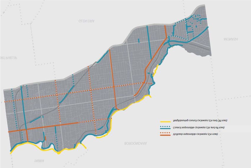
The action plan and associated costs include initiatives that are the responsibility of Council and
VicRoads. A strong partnership between Council and VicRoads is key to the successful
implementation of the Strategy and a significantly enhanced cycling network:
• Funding for the Council-responsible projects will be directed towards; maintaining and
enhancing the existing cycling trail network for which Council is responsible (off-road and some
on-road); scoping of some projects on non-Council owned land (ie. VicRoads roads) to assist
December 2013 P a g e | ixStonnington Cycling Strategy 2013-2018 draft
with the development of business cases to inform applications for funding; implementing
behavioural initiatives; and promotional and educational activities.
• External funding for the VicRoads-responsible projects is required for the development of on-
road cycle lane treatments on VicRoads responsible roads. These projects (and funding of) are
critical to the successful achievement of the aspired Stonnington cycling network.
Monitoring implementation of the Strategy
For monitoring Council’s impact on increasing participation in cycling, various surveys have been
implemented in the past which establish participation rates and set a benchmark for measuring
change. These surveys (or a combination of) should be implemented annually to continue to
measure change, including; the Sustainable Transport Survey, the Stonnington Active Travel Survey
(implemented through the Ride 2 School program), ‘Super Tuesday’ counts, the Staff Sustainable
Transport (cycling) Survey, automatic / manual counters, data from the Australian Census of
Population and Housing on transport modes and destination for the journey to work.
A cross departmental group of Council Officers with a role in planning and providing for cycling has
been formed to ensure that cycling projects are appropriately coordinated. This group will continue to
meet periodically to plan budgets, coordinate capital works projects and program annual
implementation plans.
The Stonnington Cycling Reference Group was formed in 2013. This Group comprises residents,
Councillors and Council Officers with the aim of working together to consider cycling issues and
opportunities. The Group will provide a sounding board for implementation of the Cycling Strategy,
including preparation of the annual implementation plans, revision of priorities and review of issues
and outcomes.
A status report providing an update on progress of implementation of the Strategy will be prepared
annually and presented to the Stonnington Cycling Reference Group and Council.
December 2013 Page |xStonnington Cycling Strategy 2013-2018 draft
1 Introduction
This document presents the vision, strategic directions and actions for implementation to improve
opportunities for cycling in Stonnington over the next five years (2013 to 2018).
The Stonnington Cycling Strategy aims to... enhance the physical and social environments to
support people to cycle. The strategic framework addresses all cycling facilities, including paths,
roads and cycle ways and associated infrastructure (such as signage, resting places and parking
facilities), as well as programs and services to promote and encourage participation. In particular, the
Strategy focuses on ensuring good access to key local destinations in Stonnington (such as shopping,
education, recreation and employment locations) and cycling safety.
The objectives driving development of the Strategy are:
• To address all elements of cycling; including on and off-road cycling infrastructure and facilities,
programs and services.
• To review the on and off-road cycling network for connectedness, functionality, quality and
ancillary infrastructure.
• To review relevant literature to ensure the Cycling Strategy is correctly set within the current
policy context and reflects relevant Council priorities and commitments.
• To review participation patterns of the community with respect to cycling behaviour, and, and
the impact on cycling participation of population trends and forecasts.
• To define the stakeholders with a role in cycling provision and promotion in Stonnington, and
particularly to outline the role of Council.
• To apply a behaviour change philosophy to the Cycling Strategy as the foundation informing
the strategic approach taken to cycling provision and development.
• To consider environmental sustainability as a desired outcome of Council’s approach to the
development of opportunities for cycling.
• To incorporate safety as a major objective for all cycling improvement initiatives.
• To develop a strategic framework for encouraging more Stonnington residents to cycle, and
those who already cycle to do so more often.
• To prepare a detailed five-year action plan designed to achieve implementation of the strategic
intent of the Strategy, with an associated estimation of cost.
This Strategy coincides with the release of the Victorian Government’s strategic direction for cycling
through the ‘Cycling Into the Future 2013-2023’ strategy, which aims to make it easier for more
people to cycle, and make it safer for people who already ride.
The strategic framework and directions discussed in this report have been developed based on
detailed analysis and investigation into the range of factors that impact on cycling. In particular, two
background documents have been prepared which have informed and support this report. These
include:
Cycling Discussion Paper, CDM Research, March 2012 – this study provides a detailed
assessment of the existing on and off road cycling networks, cites case studies of methods
used by other land managers for providing for safe and accessible cycling.
A New Future for Cycling in Stonnington 2013-2023 and Beyond, GHD, April 2013 –
this report combines all previous research to provide a strategically focussed appraisal of
conditions for cycling and opportunities for improving the cycling system, facilities and
infrastructure. This report has been formative in the development of this Cycling Strategy
2013-2018.
December 2013 Page |1Stonnington Cycling Strategy 2013-2018 draft
These studies have undertaken detailed reviews of relevant literature, involved consultation with
Council staff with a role in planning, developing and managing on and off road cycling infrastructure,
and reviewed data pertaining to cycling participation. Various methods for providing for safe cycling
have been considered and new initiatives in cycling infrastructure are also explored in the reports.
This document draws on the key issues and strategic intent of these documents to provide a succinct,
achievable five-year strategic direction and development program, as presented in this report.
1.1 The approach
The Strategy is based on an holistic approach which considers the physical, social, individual and
political factors that combine to influence a person’s decision to cycle. Accordingly, the Strategy
seeks to address each of these elements within the Stonnington context, taking account of local
demographic characteristics, land-use (including existing cycling infrastructure and networks), and
cultural factors. The elements are described following, and the inter-relationship between these
elements is illustrated in Figure 1:
• Intrapersonal factors – these are factors which are specific to us as individuals (eg. our self
confidence in our ability to ride a bicycle).
• Social factors – these factors are specific to societies (eg. the influence of friends, family and
colleagues).
• Policy and regulation – refers to the influence of wider government policy and regulation (eg.
enforcement of road rules).
• Physical environment – this is both the built and natural environment (eg. bicycle routes and
end-of-trip facilities).
FIGURE 1. BEHAVIOUR CHANGE FRAMEWORK GUIDING PREPARATION OF THE CYCLING STRATEGY
Factors that are specific to us as Factors specific to societies (eg. the
individuals (eg. our self-confidence in influence of friends, family and
our ability to ride a bicycle) colleagues)
The built and natural environment (eg. The influence of wider government
bicycle routes and end-of-trip policy and regulation (eg. enforcement
facilities) of road rules)
Source: A New Future for Cycling in Stonnington 2013-2023 and Beyond, GHD
December 2013 Page |2Stonnington Cycling Strategy 2013-2018 draft 1.2 Vision for cycling in Stonnington Council’s vision for cycling in Stonnington is that; Cycling will be widely undertaken in Stonnington, whether for fun, fitness or travel – providing health, economic, social and environmental benefits to the community. Participation will be encouraged by facilities, programs and services. Travel throughout Stonnington by bicycle will be easy and safe, supported by a comprehensive network of accessible and convenient paths, laneways and trails that are accompanied by facilities that provide for resting and storing / securing bicycles. It will be particularly easy to access local facilities and gathering places. This Strategy sets out the ‘road map’ to guide Council in working towards achieving its vision. In particular, the Strategic Goals and Strategic Directions discussed in Section 6 define how the vision mixes with the four behavioural elements discussed previously to arrive at recommendations for action. December 2013 Page |3
Stonnington Cycling Strategy 2013-2018 draft
2 Background
Cycling is an activity commonly undertaken by people of all ages and levels of ability. People
undertake cycling for a range of purposes and benefits, including; sport (eg. various forms of road
racing, mountain bike riding), fitness, recreational enjoyment or as a form of transportation (eg. riding
to work / school). The majority of cyclists fit within the latter two categories of cyclists (ie. recreational
riders and commuters).
Cycling in Stonnington is provided via a range of avenues by various stakeholders, including:
• Shared trails (off-road); paths and trails shared between cyclists and pedestrians in parks and
open spaces – these are primarily the responsibility of Council (where Council is owner of the
land). The main off-road trails in Stonnington are; Capital City Trail and Main Yarra Trail
(running along the Yarra River), the Gardiner’s Creek Trail (running along Gardiner’s Creek and
providing a critical connection to the Capital City Trail), and the Scotchman’s Creek Trail.
• On-road bike lanes; exclusive bike lanes, clearway bike lanes, shared car parking and bicycle
lanes, exclusive bicycle lanes, and bicycle headstart (storage) boxes – Council and VicRoads
are the key organisations responsible for infrastructure on roads;
• Ancillary infrastructure; such as signage (regulatory, warning, guidance), parking facilities and
storage boxes – responsibility for these items rests with the authority responsible for the road
infrastructure which will be either Council or VicRoads;
• Programs and services, such as riding tuition, cycling adventures and events, maps and
information (such as the TravelSmart map) – Council is one of a number of service providers,
including community groups and community organisations; and
• Promotion and information – this is provided by Council, other agencies, community groups and
businesses.
Shared paths & trails
On-road bike lanes
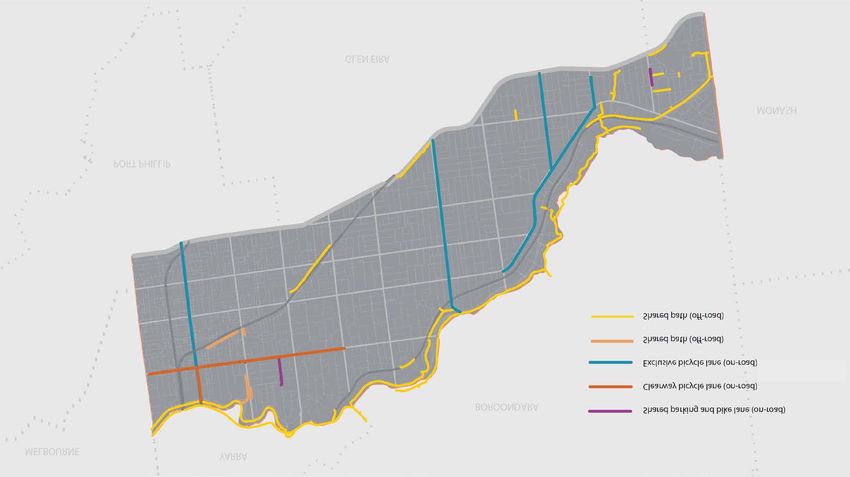
December 2013 Page |4Stonnington Cycling Strategy 2013-2018 draft Ancillary infrastructure The existing ‘designated’ cycling network in Stonnington covers an estimated 22 kilometres of off-road trails, and 29 kilometres of on-road bike lanes (not including kilometres of other streets also used by cyclists not formally designated as cycling routes) providing a range of opportunities to cycle within and through the City. The following diagram (Figure 2) shows the current cycling network in Stonnington, including on and off road trails under the responsibility of Council and other stakeholders. December 2013 Page |5
Stonnington Cycling Strategy 2013-2018                                                                               draft
FIGURE 2. EXISTING ON AND OFF ROAD BICYCLE NETWORK BY FACILITY TYPOLOGY (COUNCIL AND NON-COUNCIL RESPONSIBILITY)

Source: A New Future for Cycling in Stonnington 2013-2023 and Beyond, GHD

December 2013                                                                                                      Page |6
Stonnington Cycling Strategy 2013-2018                                                         draft

2.1     Providers of cycling in Stonnington
The City of Stonnington is one of a few key stakeholders with a role in planning, providing, managing
and promoting cycling opportunities in Stonnington. The roles of Council and other providers are
discussed in this Section.

The City of Stonnington
Cycling is a cross-departmental responsibility of Council, with a number of work areas contributing to
planning, developing, providing and managing cycling facilities and services for Council-responsible
infrastructure. These work areas and their roles include:

Department             Roles
Transport and          Planning, scoping and coordination of improvements on on-road and off-
Parking                road cycling infrastructure and investigation of community requests relating
                       to usage of on-road and off-road paths
                       Liaison with VicRoads regarding cycle ways on Declared Roads
                       Auditing and monitoring of cycling infrastructure
                       Coordination and management of the Stonnington Cycling Reference Group
Public Spaces and      Design of public spaces
Capital Works          Design and construction of public open space and off-road shared trails
Physical               Maintenance of on-road and off-road cycling infrastructure
Operations
Strategic Planning     Future planning of land uses, including activity centres and identification of
                       opportunities to acquire land
Leisure and            Advocate to and educate the community on cycling behaviour and cycling
Recreation             opportunities in Stonnington
                       Provision of programs and services that encourage participation in cycling
Communications         Promotion of cycling
and Community          Responsible for the Municipal Public Health and Wellbeing Plan
Planning               Community safety

Overall coordination of Council’s activities in cycling provision is undertaken by the Sustainable
Transport Planner.

Other key providers
There are a number of other partners relevant to the provision of cycling opportunities. These
include; the Stonnington community, schools and community groups; State government; neighbouring
councils; Bicycle Network Victoria, and other working groups and networks (such as the Road Safety
Action Group of inner Melbourne councils). Council works with all of these partners and stakeholders
(as relevant) when improving opportunities for cycling.

The City of Stonnington’s participation and role in the Inner Melbourne Action Plan (IMAP) also
provides a platform for working more collaboratively with adjoining inner Melbourne municipalities to
improve cycling trail connections that provide for seamless travel by bike across Melbourne.

As owner of public land (reserves and road ways) and the custodian of many roads, the State
Government (through VicRoads) is also a major provider of cycling infrastructure, along with Council.

December 2013                                                                              Page |7
Stonnington Cycling Strategy 2013-2018 draft
VicRoads works to a hierarchy of on-road cycling trails to guide prioritisation of cycling connections
and infrastructure works. The VicRoads hierarchy involves:
• Principal Bicycle Network (PBN) - is a network of bicycle routes providing access to major
destinations in the Melbourne metropolitan area.
These locations include; Alexandra Avenue, Toorak Road, Malvern Road, High Street,
Dandenong Road, Wattletree Road, Waverley Road, Punt Road, Chapel Street, Williams Road,
Orrong Road, Kooyong Road, Glenferrie Road, Tooronga Road, Burke Road, Darling Road,
Belgrave Road, Chadstone Road, Warrigal Road, Grange Road.
• Bicycle Priority Routes (BPRs) - subsets of the PBN, based on the VicRoads hierarchy ofo roads and
road use (the SmartRoads Road User Hierarchy).
These locations include; Alexandra Avenue, Toorak Road, Malvern Road, High Street, Wattletree
Road, Waverley Road, Chapel Street, Orrong Road, Kooyong Road, Glenferrie Road, Tooronga
Road, Darling Road, Belgrave Road, Chadstone Road, Grange Road.
• Critical Route Corridors (CRCs) - the highest level of bicycle route, based on the BPRs.
Tooronga Road is the nominated CRC in Stonnington.
The following diagram (Figure 3) maps the VicRoads-responsible on-road cycle path network in
Stonnington. The map shows the expanse of this network which incorporates most major north-south
and east-west roadways across the municipality.
The map also differentiates between those on-road cycleways that are existing, and those which form
part of the proposed network but are not yet in existence (the dotted lines).
December 2013 Page |8Stonnington Cycling Strategy 2013-2018 draft FIGURE 3. EXISTING AND PROPOSED STRATEGIC ON-ROAD BICYCLE NETWORK (VICROADS RESPONSIBILITY) Source: A New Future for Cycling in Stonnington 2013-2023 and Beyond, GHD December 2013 Page |9
Stonnington Cycling Strategy 2013-2018                                                            draft

3       Key factors informing the Cycling Strategy
3.1      Policy context
Council’s major plans that set the overall strategic direction of Council’s activities are the
Council Plan, followed by the Municipal Strategic Statement and Municipal Public Health and
Wellbeing Plan. The main elements of these documents that influence the development of the
Cycling Strategy are summarised following:

Council Plan 2013-2017
The Council Plan 2013-2017 is the key guiding document for Council. It categorises Council’s
operations into four areas of focus; Community, Environment, Liveability and Prosperity. Each
area of focus has a key strategic objective, strategies and strategic indicators. A series of
budget activities are nominated for each strategy. The following diagram shows the relevance
of the Council Plan to the Cycling Strategy:

Municipal Public Health and Wellbeing Plan 2013-2017 (MPHWP)
The MPHWP identifies actual and potential public health issues affecting the community, and
outlines strategies to achieve improved health status of residents. The Plan is based around
five pillars; Active and Healthy Lifestyle, Alcohol and Tobacco, Health Equity, Mental Health,
and Safe Community.

Cycling is relevant to the strategies within the Active and Healthy Lifestyle pillar. In particular,
the MPHWP will work towards:
    •   Promoting and providing for active transport such as walking and cycling;
    •   Continuing to develop partnerships to increase sport and active recreation opportunities;
        and
    •   Increase participation in physical activity, across all age groups, by providing safe,
        inclusive and accessible environments.

Municipal Strategic Statement (MSS)
The MSS contains the strategic objectives for land use and development throughout the City
and the strategies for achieving them. It provides the basis for the use of zones and other land
use controls within the planning scheme and makes provision for any changes in land use to fit
Council and the community’s objectives. In relation to cycling, the MSS plans for public open
space and the provision of land to support the community to engage in physical activity.

December 2013                                                                                P a g e | 10
Stonnington Cycling Strategy 2013-2018 draft
Other relevant strategic plans
There are a number of other key strategic documents that have relevance to cycling planning,
provision and management. These, and a summary of the key areas of consideration for the
Cycling Strategy is provided following:
• Stonnington Sustainable Transport Policy and Background Paper - These
documents outline Council’s position on transport, for both Council staff and external
stakeholders, with the aim of achieving a hierarchy that prioritises more sustainable
modes of transport, according to the following; walking, cycling, public transport,
commercial vehicles serving local businesses and institutions, multiple occupancy
vehicles, and single occupancy vehicles.
• Stonnington Walking Policy and Background Paper - This document plans for
increased levels of walking and improved pedestrian access within Stonnington. It
focuses on increasing pathway and trail connections, accessibility and crossing points to
achieve a more cohesive and safe network to encourage walking and give people the
choice of walking, cycling or travelling by public transport for most journeys.
• Road Safety Policy 2008-2017 – The policy aligns with the State government’s road
safety strategy and aims to reduce road related fatalities and serious injuries in the
municipality by 30% from 2008 to 2017. Council utilises the Safe System framework to
deliver this policy. The Safe System includes improving the safety conditions of roads
and roadsides and promoting safe road safety behaviour of road users.
One of the objectives of the policy is to improve the safety of vulnerable road users
including pedestrians and cyclists in Stonnington. Some actions that Council has
undertaken to meet the objective is to reduce vehicle speed to 40 km/h in many of the
local streets in the municipality, to install traffic calming devices (kerb outstands,
roundabouts, speed humps) to reduce vehicle speed, and to implement line marking and
signage for cyclists.
• The Stonnington Bicycle Parking Implementation Plan provides a basis for
significantly enhancing bicycle parking in Stonnington. The Plan identifies sites
throughout the City appropriate for the installation of bicycle parking infrastructure, of
which activity centres and points of community congregation are priorities, along with
additions to cycle routes.
• Public Realm Strategy (2010) – The Strategy considers all green and urbanised public
spaces to establish the future direction for the development and management of the
public realm in Stonnington with the aim of enhancing a sense of place, community
wellbeing and accessibility. The Strategy is based around ensuring that the management
of Stonnington’s public realm will protect vital assets and ensure the preservation of the
cornerstone of Stonnington’s unique identity. ‘Linkages’ is one objective of this vision,
with a focus on improving the quality of linkages through providing connections and
providing signage and lighting to enhance use.
• Building Prosperity: Economic Development Strategy 2012-2016 – The Strategy is
based on four pillars, with ‘Thriving Precincts’ being of most relevance to the Cycling
Strategy. The Strategy supports continued investment in infrastructure to develop
optimum streetscapes, footpaths, street furniture, public toilets and lighting as well as
sculptures and art based initiatives; and advocating and supporting improvements to
sustainable transport and improved public transport services.
A number of additional studies have been considered in the literature review, including:
• Chapel Street Cyclist Provision study (2012)
• Draft Chapel ReVision Transport Strategy (2012)
• Stonnington Road Safety Audits (2012)
December 2013 P a g e | 11Stonnington Cycling Strategy 2013-2018 draft
• Stonnington Bicycle Parking Report (2010)
• Bridge Feasibility Study: Gardiners Creel Trail at Glenferrie Road (2010)
• Sustainable Urban Transport Survey Report (2012)
• BikeScope Online Consultation Survey (2011)
• Super Tuesday Bicycle Commuter Survey (2011)
• Gardiners Creek Path – Bicycle Safety Review: Elm Road Creek Bridge, Glen Iris (2012)
• Submission from the Stonnington Bicycle Users Group (2012)
• Regional Shared Trail Cremorne To St Kilda East Strategy Report (2010)
• Yarra River Biodiversity Linkages Project (2010)
Implications for the Cycling Strategy:
• Participation in cycling should be encouraged as it provides a healthy activity option and
a sustainable form of transport. Both of these attributes can have positive impacts on
residents and the broader community.
• There is a need to provide high quality amenity cycling facilities and environments to
encourage use. These must be accessible and perceived as being safe.
• Addressing trail connections are also a key imperative to encouraging participation in
cycling.
3.2 Participation trends and other drivers of participation
3.2.1 Travel patterns and behaviours
The 2011 Census of Population and Housing (Australian Bureau of Statistics) provides
information on travel data. A review of this data has been undertaken to identify trends and
behaviours of the Stonnington community. The key statistics and their relevance to planning for
cycling are:
• Driving a car (46.0%) remained the primary method of travel to work in 2011, but at a
lesser rate from in 2006 (48.5%).
• The second largest proportion of residents (25.6%) travelled to work by public transport
(train, bus and tram) in 2011 – travel by this mode increased by over 25% between 2006
and 2011.
• While travel to work by bicycle is still a very low mode of transport for Stonnington
residents, it has increased. The number of Stonnington residents who cycled to work
approximately doubled between 2001 and 2011 (from 607 people to 1,221 people).
• In 2011, travel to work by bicycle represented 2.4% of all trips to work by Stonnington
residents (refer Figure 4), an increase from 1.8% in 2006. The largest proportions of
residents who travelled to work by bicycle lived in the west of the City (Prahran, Windsor,
South Yarra).
December 2013 P a g e | 12Stonnington Cycling Strategy 2013-2018 draft FIGURE 4. VOLUMES OF TRAVEL TO WORK BY BICYCLE BY STONNINGTON RESIDENTS Source: http://profile.id.com.au/stonnington December 2013 P a g e | 13
Stonnington Cycling Strategy 2013-2018                                                             draft

FIGURE 5.   TRAVEL    TO WORK BY BICYCLE COMPARING    STONNINGTON   PARTICIPATION RATES TO NEIGHBOURING
MUNICIPALITIES

  •    Figure 5 shows that, in comparison to most surrounding areas, the rate of travel to work
       by Stonnington residents is lower than its neighbouring inner city municipalities and
       higher than the municipalities further away from the centre of Melbourne. Rates of
       residents’ travel to work by bicycle among the councils neighbouring the City of
       Stonnington are highest in Yarra, Melbourne and Port Phillip (being 10.5%, 7.1% and
       5.0% respectively) as shown in the following table.

        Municipality             % residents who
                                 cycle to work
        Yarra                           10.5
        Melbourne                        7.1
        Port Phillip                     5.0
        Stonnington                      3.0
        Boroondara                       2.4
        Glen Eira                        1.8
        Monash                           1.0
       Source: Census 2011

Source: Census 2011

       City of Melbourne
                              City of
                              Yarra

                                                     City of Boroondara

            City of Port            City of Stonnington
                  Phillip

                                                                             City of Monash
                                         City of Glen Eira

  •    In 2010 the participation rate in cycling for exercise, recreation or sport (according to an
       Australian Sports Commission survey) for Victorians aged 15 years and over was 12.7%.
       This represented an increase of 14.5% on the participation rate for 2006 and 20% growth
       between 2001 and 2010.

December 2013                                                                                 P a g e | 14
Stonnington Cycling Strategy 2013-2018 draft
• Participation in cycling for exercise, recreation or sport by females was approximately
half the rate of participation by males in 2010. This trend is consistent over the three
survey periods analysed, as far back as 2001.
• More specific to utilisation of cycling paths and trails in Stonnington, counters in the
Gardiner’s Creek trail to measure cyclist numbers (2010) provide the following data;
5,127 bikes were counted over the 12 months at two separate sites along this trail
(therefore there will be some double up in this number).
• A survey (Super Tuesday Bike Commuter Survey: IMAP – City of Melbourne, Yarra City
Council, City of Stonnington, City of Port Phillip) conducted by Bicycle Victoria to count
commuter cyclists in Stonnington in March 2012 identified 703 riders at the busiest count
site in Stonnington (the intersection of Chapel Street / Church Street and Alexandra
Avenue). This number placed this site as the eighth busiest Australia-wide. Five of the
six sites with the largest number of riders were located along Chapel Street. Analysis of
the survey results by Bicycle Victoria indicated that the numbers of riders travelling along
High Street increased significantly from 2011 to increase the prevalence of this route as a
key east-west route for commuter riders. Chapel Street also remained a key route for
north-south travel.
December 2013 P a g e | 15Stonnington Cycling Strategy 2013-2018 draft
3.2.2 Cycling related incidents and accidents
A review of cycling-related accident data (as presented in the Cycling Discussion Paper, CDM
Research, 2012) shows that:
• The number of cycling injuries increased by over one third from 2000 to 2010. This will
be at least partially attributable to the increase in cycling trips (25% between 2006 and
2011).
• The number of serious injuries remained stable over this period but a significant increase
was shown for minor injuries.
• The main type of crash for serious injuries was when a cyclist turned right into the path of
an oncoming vehicle. This was followed by motorists opening car doors into the path of
an oncoming cyclist (known as car-dooring) which was also the type of crash that caused
the most minor injuries.
Other issues of note included:
• Three quarters (74%) of crashes involving cyclists occurred during the day.
• 39% of crashes occurred on a road and not at an intersection. However, 37% occurred
at a t-intersection.
• 63% of crashes occurred at stop-go light traffic controls.
• 64% of crashes occurred on declared (main) road, or at intersections with declared
roads.
• 22% of all crashes occurred on Chapel Street, where car-dooring was the primary crash
type.
These statistics are illustrated in Figures 6 and 7 following which show the prevalence and
dispersal of cycling related accidents and injury types:
FIGURE 6. BICYCLE CRASHES BY SEVERITY
Source: A New Future for Cycling in Stonnington 2013-2023 and Beyond, GHD
December 2013 P a g e | 16Stonnington Cycling Strategy 2013-2018 draft
FIGURE 7. BICYCLE CRASHES BY TYPE
Source: A New Future for Cycling in Stonnington 2013-2023 and Beyond, GHD
Implications for the Cycling Strategy:
• Participation in cycling (recreational and commuter) is increasing.
• Participation by females is a lot less than males – this presents a target group to
encourage participation.
• Addressing safety should be a major consideration of future provision for cycling, as
cycling related injuries have increased.
• The concentration of incidents on Chapel Street highlights this location as an ongoing
priority.
3.3 Community profile and population change
The characteristics of the Stonnington population have been reviewed to identify factors that
relate to cycling and trends that will guide Council’s consideration of provision for cycling.
Based on analysis of data from the Census of Population and Housing (2011), it is concluded
that, demographically, Stonnington (like most inner Melbourne municipalities) has no discerning
issues that might affect participation in cycling.
The key characteristics of note are:
• The median age of the community was 35 years, which was slightly below the Greater
Melbourne and Australian medians of 36 and 37 years respectively.
• The City of Stonnington had a lower proportion of pre-schoolers and a higher proportion
of people at post retirement age than Greater Melbourne.
• Approximately 48.1% of the Stonnington population were male and 51.9% are female.
• Approximately 95.6% (50,933 people) of Stonnington’s eligible labour force were
employed, slightly above the Greater Melbourne average (94.5%).
December 2013 P a g e | 17Stonnington Cycling Strategy 2013-2018 draft
• Approximately two thirds (67%) of the labour force were working full time and 31% part
time.
The implications of these population trends for cycling include:
• A young and very well educated population provides an ideal foundation for the adoption
of new ideas and behaviours.
• The increasing proportion of medium to high density housing and mixed-use
development reduces dependence on car ownership and use and promotes journeys by
alternative modes of transport (such as walking, cycling and public transport).
• Stonnington has a high proportion of young professionals willing to live in higher density
development close to key destinations and who are known to be relatively less car
dependent, and happy to commute to their local destinations by foot, public transport or
by bike.
• The relatively high proportion of primary school aged children in Stonnington presents an
opportunity to work with this population group to establish good travel habits and cycling
practices (e.g. through the Ride 2 School Program)which are likely to be carried through
to adulthood.
Implications for the Cycling Strategy:
• The profile of the Stonnington community is well suited to encouraging participation in
cycling.
3.4 Land use and development
With one of the largest populations among inner Melbourne municipalities and a high proportion
of medium to high-density development, Stonnington has an environment that supports short
local trips by bicycle.
• The total municipal population at 2011 was 93,145 (estimated to be 104,045 in 2013).
There was a population density of 39.3 persons per hectare, ranging from 26.7 people
per hectare in Malvern East to 62.8 people per hectare in Windsor. The local population
is expected to grow by 28,836 (31%) between 2011 and 2031, or 1.55% per annum.
• Approximately two thirds (64%) of housing stock in Stonnington is medium to high
density compared with 28% for Greater Melbourne and 25% Australia-wide.
• Stonnington in characterised by a significant number of key land-uses located within 1-2
km catchment of most residential areas, supporting the trend of short local trips which are
well suited to cycling as a form of convenient travel.
• The municipality has a relatively flat topography with small proportion of gradients over
10%. There are also relatively low levels of rainfall, and high levels of sunshine provides
a climate conducive to cycling.
• There is also a relatively permeable network of roads and streets although the limited
width of some streets impacts on the ability to provide bicycle lanes / infrastructure.
• The width of some streets is not sufficient to cater to the range of uses they attract which
can create congestion between users. There are also some streets that are sufficiently
wide enough to accommodate specialised bicycle provision.
• The east-west spine comprising Scotchman’s Creek, Gardiners Creek and the Capital
City Trail provide an excellent opportunity to access many land-uses (eg. rail stations and
green open space) both within and outside Stonnington (eg. the CBD).
December 2013 P a g e | 18You can also read