BURIAL GROUND & INTERMENT STRATEGY - Limerick.ie
←
→
Page content transcription
If your browser does not render page correctly, please read the page content below
BURIAL GROUND & INTERMENT
         STRATEGY

            1
TABLE OF CONTENTS

1.0     INTRODUCTION
1.1           Legislative Background
1.2           Historical summary of the Burial and Churches in Limerick
1.3           Existing Burial Grounds in Limerick
1.4           Funding of Burial Grounds
1.5           Maintenance of Burial Facilities
1.6           Management and Control of Burial Grounds

2.0     DATA COLLECTION
2.1           Burial Ground Survey
2.2           Population S urvey

3.0     ASS-ESSMENT OF NEEDS
3.1            City & County-wide
3.2            Municipal Areas
3.2.1          Cremations
3.3            Metropolitan District
3.4            Cappamore-Kilmallock District
3.5            Adare Rathkeale District
3.6            Newcastle West District

4.0     PROVISION OF BURIAL FACILITIES TO MEET NEEDS
4.1           Provision of New and Extensions to Existing Burial Grounds by the Council
4.2           Provision of New and Extensions to Existing Burial Grounds by Local Groups
4.3           Historic Burial Grounds

5.0     HISTORIC CHURCH BUILDINGS
5.1           Ownership background
5.2           Church Architecture
5.3           Legal status
5.4           Best practice
5.5           The survey
5.6           Adare-Rathkeale District: archaeological and architectural assets
5.7           Cappamore-Kilmallock District: archaeological and architectural assets
5.8           Metropolitan District: archaeological and architectural assets
5.9           Newcastle West District: archaeological and architectural assets
5.10          Summary of preliminary condition survey

6.0     SUMMARY & RECOMMENDATIONS

                                                2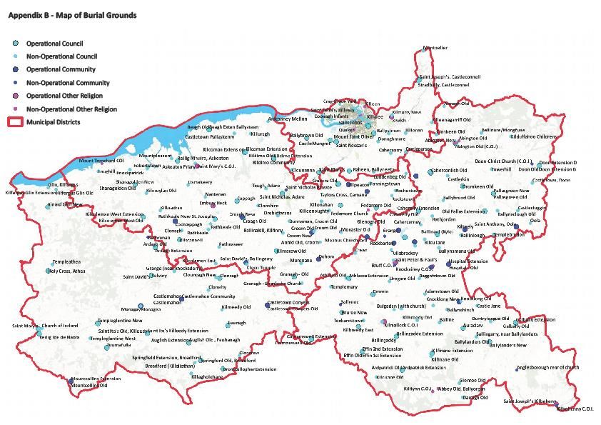
APPENDICES

Appendix A - List of all Burial Grounds in Limerick including active and full
Appendix B – Map of Burial Grounds
Appendix C – Metropolitan District Map
Appendix D – Cappamore-Kilmallock District Map
Appendix E – Adare-Rathkeale Municipal District Map
Appendix F – Newcastle West Municipal District Map
Appendix G – Image of Columbarium Wall
Appendix H – Catalogue of Heritage Assets

List of Figures:
Figure 1. Population by Municipal District
Figure 2. Annual average number of deaths in Limerick
Figure 3. Number of year’s capacity in Limerick Burial Grounds by Municipal Area
Figure 4. Total survival within Local Authority graveyards
Figure 5. Heritage Assets by Municipal District
Figure 6. Preliminary condition assessment, Adare-Rathkeale Municipal District
Figure 7. Preliminary condition assessment, Cappamore-Kilmallock Municipal District
Figure 8. Preliminary condition assessment, Metropolitan Municipal District
Figure 9. Preliminary condition assessment, Newcastle West Municipal District
Figure 10. Overview of preliminary condition assessment in the LA Graveyards

List of Tables:
Table 1. Distribution of burial grounds across the Municipal Districts.
Table 2. Active Burial Grounds with available burial plots
Table 3. Population by Town & Village (2016 CSO)
Table 4. Population with age profile in each Municipal District
Table 5. Population by Municipal District with annual average burial plot purchases
Table 6. Summary of burial ground capacity in Limerick (2020)
Table 7. Metropolitan District: Summary of burial ground capacity by Electoral Area
Table 8. Cappamore-Kilmallock District: Summary of burial ground capacity by Electoral Area
Table 9. Adare-Rathkeale District: Summary of burial ground capacity by Electoral Area
Table 10. Newcastle West District: Summary of burial ground capacity by Electoral Area
Table 11: Preliminary assessment of heritage assets within LC&CC burial ground
Table 12. Preliminary condition survey by Municipal District

                                                    3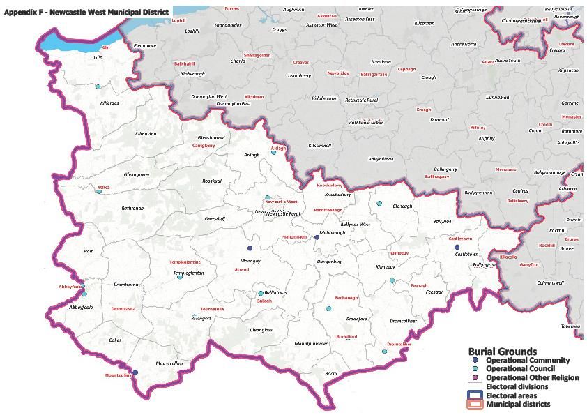
1.0           INTRODUCTION

Limerick City and County Council has a central role in ensuring the proper provision of burial
grounds in appropriate locations throughout the City and County. In order to ensure that there
are sufficient burial spaces to serve the needs of the people of Limerick for the future, a Burial
Ground and Interment Strategy is required.

The strategy must consider the best use of the available resources and the proximity of the location
of burial grounds to the population of areas served within Limerick. The Burial Ground Strategy must
also give priority to areas where the need is greatest. The strategy must also consider changing trends
in burial practices and projected future requirements. This Burial Ground Strategy will address burial
needs for the next 20 years.

The Local Authority also recognises its responsibility of care for the many heritage assets within
its older graveyards. Therefore, this strategy will also consider these assets, providing a data set
and a preliminary condition survey. This information will inform the future strategy and will assist
in the prioritisation of funding for remedial works to these historical structures.

1.1           Legislative Background

The Department of Rural and Community Development has responsibility for policy and legislation in
relation to local authority burial grounds. The operation of burial grounds is the responsibility of the
local authorities.

The Public Health (Ireland) Act of 1878 (Part III) provides for the provision, maintenance and
control of burial grounds. The local authority acting as the sanitary authority became the burial
board for each sanitary district. In the interests of public health, power was given to local
authorities to restrain the opening of new burial grounds and to order the discontinuation of
burials in specified places.

The main rules for burial grounds are set out in the Rules and Regulations for the Regulation of Burial
Grounds 1888 and amendments made to these rules in 1919, 1929 and 2013.

The National Monuments Act 1930-2014 deals with the protection and preservation of National
Monuments, Recorded Monuments and Historic Monuments. Almost all of the older burial grounds
are Recorded Monuments and some are also designated National Monuments.

The Local Government (Sanitary Services) Act of 1948 also deals with the disposal of bodies. It
provides that bodies must only be buried in properly designated burial grounds. An exception to
this is that a clergyman may be buried in or adjacent to a church. The 1948 Act also makes
provision for the exhumation of bodies.

The 1994 Local Government Act amended the law and essentially provided that any person or
group could develop a burial ground subject to obtaining full planning permission. This is a
significant change which facilitates the provision of burial grounds by persons or groups other
than local authorities, but particularly local community groups. The law in relation to the

                                                   4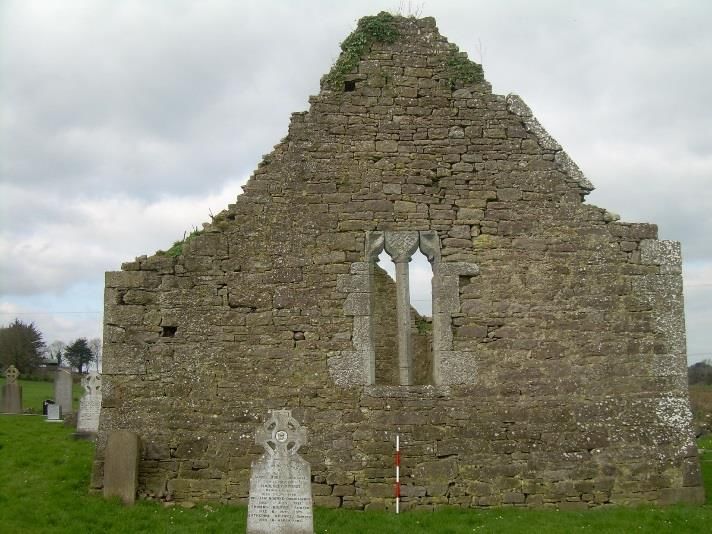
exhumation of bodies was also amended by this Act.

The Burial Ground (Amendment) Regulations 2013 amended the 1888 Regulations to allow for
uncoffined burials in an area of a burial ground designated exclusively for that purpose.

Limerick City & County Council Cemeteries Bye Laws 2015 were enacted 7th December, 2015. These
bye laws were made by Limerick City and County Council under Local Government Act 2001 (as
amended) for the regulation of cemeteries in the administrative area of Limerick City and County
Council. The first eighteen bye- laws apply to all graveyards within the functional area. These Bye Laws
cover items such as opening of graves, grave depth, headstones, exhumations and gravespace
management.

1.2           Historical summary of the Burial and Churches in Limerick

There are many ways of commemorating the dead. The elaborate passage grave at Newgrange, dating
to 3200 BC, still stands as a testament to those within, while modern practices can consist of a
scattering of ashes leaving no physical monument other than memory. In prehistory, there is a range
of monuments associated with the deposition of the dead, megalithic tombs, cist, pit and urn burials,
mounds and barrows and examples of these are found across Limerick. Inhumation (burying the body)
had gradually superseded cremation from the beginning of the first millennium AD and it is likely that
the earliest Christian burials were interred in pre-existing ‘pagan’ sites, which would have had family
or tribal connections. The first formal Christian cemeteries on the Continent date from the 8th century.
In Ireland, these would have been associated with the early monastic settlements such as Mungret and
Ardpatrick and others which have not survived. The Ardagh Chalice dates from this time.

With the advent of the Anglo-Normans, the parochial system was more firmly established and became
the basic unit of government in the country. Parish churches were constructed usually associated with
the manor or reusing early church sites, such as Clonshire or Donoghmore. If a church had parish status,
it was required to provide a graveyard. The sanctified area surrounding the church would have included
the graveyard but would have had a wide range of secular uses such as fairs, holding courts, swearing
oaths and making contracts, penance, habitation of refugees and storage of valuables. Although few
inscribed grave markers predate the late 18th, the graveyards themselves have been in use for many
hundreds of years. Some graveyards would have had charnel houses or ossuaries where exhumed
skeletons were stored after the body had decayed.

Following the Reformation, the monasteries were dissolved (1536) and the Reformed Church became
the Established State Church. The parish graveyards, however, were interdenominational and
continued to function for the entire community. The Church of Ireland had a role in providing local
services such as street cleaning, poor relief, although these were more often provided through the
Grand Jury system, but the parishes remained as the units of local government.

In the mid 19th century, legislation was passed to enclose all graveyards with walls as a public health
measure and many of the handsome gates, piers and the traditional coffin-rester entrances date from
this time. From at least the 18th to the 20th centuries, unbaptised children, suicides and unidentified
persons were restricted from formal burial grounds. Often referred to as Children’s Burial Grounds, Kill
or Killeen, informal areas were created in patches of uncultivated ground with rows of low uninscribed
gravestones or sometimes in ancient monastic enclosures or dis-used graveyards or ringforts. New

                                                   5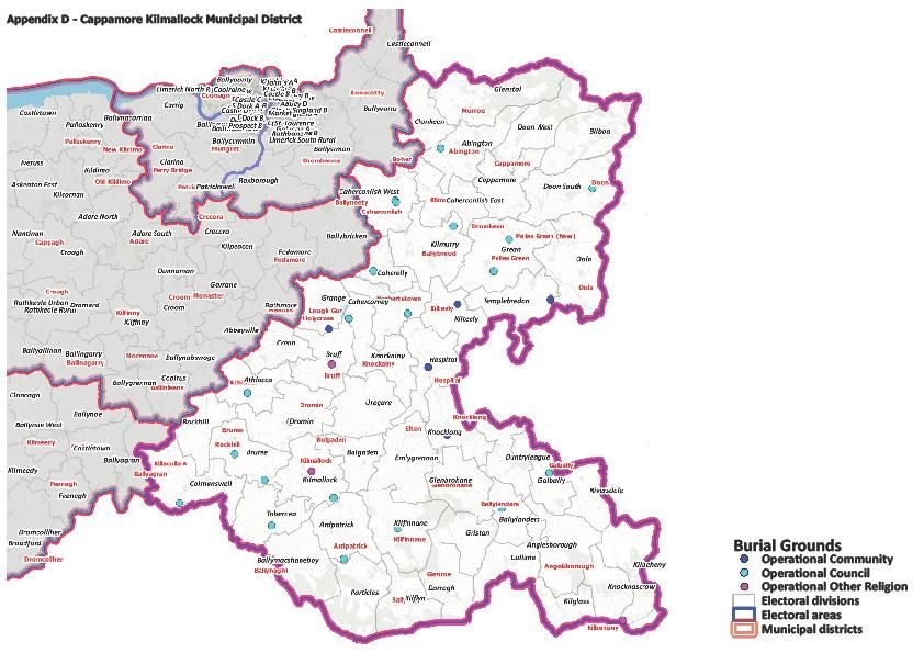
mass burial grounds were created in response to the Famine, these were usually associated with the
system of Workhouses created across the city & county such as Kyletaun near Rathkeale.

The Church of Ireland was disestablished in 1869. The Commissioners of Church Temporalities was set
up to enumerate all Church of Ireland property and to see to its disposal. This work included all churches
and graveyards. At this time, many of the graveyards came under the care of the Board of Guardians
of the Poor Law Unions or the Burial Boards of the Public Health (Ireland) Act 1878. These
responsibilities eventually came to be vested in the local authorities. The churches at Dysert, Clonkeen,
Mungret and Killaliathan/Killagholihane were given to the Board of Works and became National
Monuments. Subsequently, other churches and abbeys have been taken into State ownership or
guardianship, such as Hospital Church, Killeen, Killulta, Kilrush & Kilmallock.

1.3         New and Existing Burial Grounds in Limerick City & County

Limerick City and County Council is responsible for the maintenance of the majority of the burial
grounds in Limerick. A small number of burial grounds are maintained by local parishes and community
groups, with assistance provided by the Council. In total, there are 267 burial grounds in Limerick of
which 69 have available spaces for purchase. The remaining burial grounds have capacity in
existing family plots. All burial grounds are non-denominational. The Council is responsible for
the provision of new burial grounds and extensions to existing burial grounds. The Council
provides grant aiding to some local communities who wish to develop community graveyards.

1.4             Funding of Burial Grounds

The provision of burial ground facilities is one of the few areas of local authority responsibility where
no capital grants are provided by central government. Limerick City & County Council has to fund the
provision of new burial grounds through its own resources by way of capital funding. The resources
for capital funding are limited. Therefore, it is important that these limited resources are used
effectively. This Strategy will ensure that the provision of new burial grounds is provided where the
need is greatest. Funding for the maintenance of burial grounds is provided in the annual revenue
budget of Limerick City & County Council.

1.5           Maintenance of Burial Facilities

Limerick City & County Council has an annual programme of work which covers general maintenance
of footpaths, walls, vegetation and trees. Some of this work is assisted through local development
companies with the aid of community groups. There are numerous voluntary local committees who
carry out much needed maintenance to burial grounds in their localities. The high standard to which
these burial grounds are maintained is a credit to these local groups. The Council assists these
community efforts in a tangible manner by providing some grant assistance. The Council makes an
annual grant available to voluntary committees to assist in the cost of maintenance. An annual
Burial Ground Awards Ceremony is held where the successful groups receive additional funding
as prize money. The annual cost of these initiatives is €72,000.

1.6          Management and Control of Burial Grounds

Limerick City and County Council employs a Caretaker in majority of the 43 active Council owned burial
grounds to assist in the management and record keeping of these Burial Grounds. The caretaker is
responsible for the day-to-day monitoring of items covered by Limerick City & County Council’s

                                                   6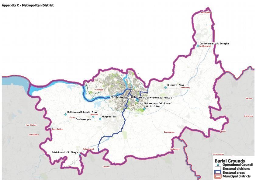
Cemeteries Bye Laws 2015 such as opening of graves, grave depth, headstones, exhumations and
gravespace management. The remaining burial grounds are managed centrally by Council staff.

                                             7
2.0 DATA COLLECTION
In order to determine the burial needs of the City and County, it was first necessary to carry out
a comprehensive survey of all existing burial grounds in Limerick. It was also necessary to
determine the current and future population of Limerick and its towns and villages and its
distribution throughout the County. The population in each town/village would provide a basis in
which to determine where there may be a greater need in a particular area and assist in the future
prioritisation of new burial grounds.
2.1 Burial Ground Survey
A comprehensive survey of all burial grounds in the City and County was carried out using
information from sources such as records held by the Council, maps, local knowledge and site
visits.
The survey work comprised of the following:
2016 Census - population in towns/villages and % mortality rate
RIP.ie – 2019 and 2020 burial data for each Municipal District
Surveying – walk over surveys, desktop surveys and GPS
Mapping burial grounds to Electoral Districts
Caretaker records – correlate RIP data
Office records – purchase of graves
The survey identified that 267 burial grounds exist in Limerick and that approximately one third
of these are actively used for the purchase of burial plots. The geographic location of these 267
burial grounds is shown in Appendix A.
Table 1 shows the distribution of the 267 burial grounds across the Municipal Districts.
Table 1. Distribution of Burial Grounds across the Municipal Districts
Municipal District No. of Burial
Grounds
Metro 40
Adare-Rathkeale 78
Newcastle West 47
Cappamore-Kilmallock 102
Total 267
There are sixty-nine active burial grounds located throughout the City and County and for the purposes
of this strategy, they have been categorised into their respective Municipal Districts. This will allow
each district to be assessed for future burial capacity. It will also have regard to adjacent burial grounds
in the adjoining Municipal District.
8The strategy will address the number of plots available in each of the burial grounds and the number
of year’s capacity remaining and will recommend where new burial grounds may be required for each
of the Municipal Districts.
The following table lists the burial grounds in each of the four districts, Metropolitan, Adare-Rathkeale,
Cappamore-Kilmallock and Newcastle West, with the respective number of burial plots available in
each of the burial grounds.
Table 2. Active Burial Grounds with available Burial Plots
Burial Ground No of Burial
Ownership Municipal District
Plots Available
Meanus (Churchyard) Catholic Church Adare-Rathkeale 14
Askeaton St Mary’s Church of Ireland Adare-Rathkeale 10
Rathkeale Church of Ireland Adare-Rathkeale 10
Ballingarry St Mary’s Community Adare-Rathkeale 200
Coolcappagh Community Adare-Rathkeale 100
Croagh (New) Community Adare-Rathkeale 300
Croom Community Adare-Rathkeale 491
Kildimo (New) Community Adare-Rathkeale 10
Taylorscross Community Adare-Rathkeale 700
Adare, St Nicholas Council Adare-Rathkeale 83
Askeaton Reilig Mhuire
Council Adare-Rathkeale 1,449
(Ext)
Beagh, Ballysteen
Council Adare-Rathkeale 10
(Exten)
Crecora (New) Council Adare-Rathkeale 456
Kilcolman Council Adare-Rathkeale 5
Kilcornan (Exten.) Council Adare-Rathkeale 394
Rathkeale St Joseph’s
Council Adare-Rathkeale 1,256
(New)
Granagh Council Adare-Rathkeale 80
Shanagolden (New) Council Adare-Rathkeale 82
Embury Heck Methodist Adare-Rathkeale 10
Total 5,570
Bruff Catholic Church Cappamore-Kilmallock 85
Bulgaden (Exten) Catholic Church Cappamore-Kilmallock 70
Grange Catholic Church Cappamore-Kilmallock 50
Hospital Catholic Church Cappamore-Kilmallock 76
Anglesborough Community Cappamore-Kilmallock 192
Kilbehenny (New) Community Cappamore-Kilmallock 60
Knockainey Community Cappamore-Kilmallock 600
Knocklong (New) Community Cappamore-Kilmallock 50
9Oola St Anthony's Community Cappamore-Kilmallock 1,450
Patrickswell Lough Gur Community Cappamore-Kilmallock 175
Abington (Exten) Council Cappamore-Kilmallock 9
Ardpatrick (Exten) Council Cappamore-Kilmallock 158
Athlacca (Exten) Council Cappamore-Kilmallock 138
Ballingaddy Council Cappamore-Kilmallock 683
Ballylanders (New) Council Cappamore-Kilmallock 13
Bruree (New) Council Cappamore-Kilmallock 698
Caherconlish (New) Council Cappamore-Kilmallock 240
Caherelly (Exten) Council Cappamore-Kilmallock 41
Colmanswell (Exten) Council Cappamore-Kilmallock 20
Doon (Exten D) Council Cappamore-Kilmallock 498
Effin (Exten) Council Cappamore-Kilmallock 490
Galbally (Exten) Council Cappamore-Kilmallock 37
Glenroe Council Cappamore-Kilmallock 70
Kilfinane (Exten) Council Cappamore-Kilmallock 557
Pallasgrean St Columba’s Council Cappamore-Kilmallock 668
Total 6,581
Ballybrown Kilkeedy
Council Metropolitian 240
(New)
Castleconnell St Joseph’s Council Metropolitian 994
Castlemungret Council Metropolitian 3,930
Mount St Lawrence Council Metropolitian 340
Mount St Oliver Council Metropolitian 3,000
Mungret St Nessan's Council Metropolitian 100
Patrickswell St Mary's Council Metropolitian 1,204
Total 9,708
Glin Catholic Church Newcastlewest 10
Castletown Conyers
Community Newcastlewest 297
(New)
Monagay (Exten) Community Newcastlewest 182
Mountcollins (Exten) Community Newcastlewest 240
Abbeyfeale former CoI Council Newcastlewest 60
Abbeyfeale Reilig Ide
Council Newcastlewest 155
Naofa
Abbeyfeale, St Mary’s Council Newcastlewest 28
Ardagh (Exten) Council Newcastlewest 145
Athea Holy Trinity
Council Newcastlewest 553
(Exten)
Auglish (Exten) Council Newcastlewest 140
Dromcollogher Council Newcastlewest 185
10Feenagh Council Newcastlewest 477
Killeedy St Ita’s (Exten) Council Newcastlewest 262
Kinard Glin (New) Council Newcastlewest 718
Newcastle West Calvary Council Newcastlewest 303
Springfield Broadford
Council Newcastlewest 100
(Ext)
Templeglantine (New) Council Newcastlewest 153
Tournafulla Council Newcastlewest 60
Total 4,068
112.2 Population Survey
Population details are recorded by the Central Statistics Office (CSO) after each census. The 2016
Census showed that the population of Limerick grew by 1.58% since the last census in 2011. The
census showed a decline in population in some rural parts of the County and a marked increase
in the environs of Limerick City. The population of Limerick is 194,899 persons with 104,952 of
the population residing in the Metropolitan area of Limerick.
Table 3 shows the population for each town and village and the various burial grounds that serve
each of these towns/villages together with the average number of burials for each town per
annum. Please note that this table only includes the population of the towns and not
surrounding hinterland.
Table 3. Population by Town & Village (Census 2016)
Average
Population No. of
Town/Village Burial Grounds servicing Town/Village
Town/Village burials per
annum
Newcastle West Calvary & St David’s 6,619 42
Annacotty Kilmurry 2,930 40
Castleconnell St. Joseph’s & Stradbally 2,107 6
Abbeyfeale Relig Ide Naofa, St. Mary’s & former CoI 2,023 16
Kilmallock, Ballingaddy, Tankardstown &
Kilmallock 1,668 22
Ardkilmartin
Caherconlish Caherconlish 1,476 12
Rathkeale St. Marys, St. Josephs, CoI 1,441 20
Murroe Abington 1,377 20
Croom Anhid, St. Mary’s 1,159 14
Askeaton Askeaton 1,137 32
Adare St Nicholas, CoI 1,129 32
Patrickswell Patrickswell 847 10
Bruff, Teampullin, Uregare, Grange,
Bruff 803 8
Meanus
Kilfinnane Kilfinane 789 6
Hospital Hospital, Patrickswell (Lough Gur) 653 8
12Pallaskenry Castletown, Copsewood 651 3
Cappamore Towerhill 620 10
Bruree Bruree 580 14
Glin Kinard, Kilfergus 576 6
Pallasgreen St. Columba’s, Old Pallas 568 10
Ballingarry St Mary’s Ballingarry 521 4
Foynes Knockpatrick, Robertstown 520 6
Drumcollogher Dromcollogher 518 10
Doon Doon 516 28
Kildimo Kildimo Old & New 417 6
Athea Templeathea & Holycross 369 14
Oola St Anthony’s 324 10
Ballylanders Ballylanders 308 10
Shanagolden Shanagolden 303 2
Clarina Kilkeedy 294 10
Mungret Castlemungret, St. Nessan’s 277 116
Broadford Springfield 276 8
Ardagh Ardagh 266 20
Knocklong Knocklong 256 4
Galbally Galbally 251 12
Croagh Croagh 216 6
Mountcollins Mountcollins 201 6
Carrigkerry Ardagh 184 1
Ballyagran Castletownconyers & Colmanswell 179 8
Kilteely Kilteely, Ballinlough, Ballinard 171 1
Toornafulla Tournafulla 144 4
13The population figures and death rates from CSO were used to estimate the average mortality
rate in Limerick. The mortality rate was calculated at 0.73%, which equates to approximately
1,423 deaths in Limerick each year. For the purposes of the analysis, it is assumed that all persons
who die in Limerick are also buried in Limerick.
Figure 1. Population by Municipal District
Population
36,635
27,416 104,952
25,896
Metro Adare/Rathkeale Newcastle West Cappamore/Kilmallock
Table 4. Population with Age Profile in each Municipal District
Municipal District Age 0-14 Age 15-64 Age 65+ Total Population
Metro 20,372 71,284 13,296 104,952
Adare-Rathkeale 5,440 16,394 4,062 25,896
Newcastle West 5,597 17,215 4,604 27,416
Cappamore-Kilmallock 8,185 22,914 5,536 36,635
Total 39,594 127,807 27,498 194,899
Table 5. Population by Municipal District with Burial Plot
Av. No. of burial plot No. of Burial
Municipal District Population
purchases per Year Plots Available
Metro 104,952 197 9,708
Adare-Rathkeale 25,896 170 5,570
Newcastle West 27,416 116 4,068
Cappamore-Kilmallock 36,635 163 6,581
Total 194,899 646 25,927
14Figure 2. Annual Average Number of Deaths in Limerick
Av. No. of Deaths per Year
292
637
192
302
Metro Adare/Rathkeale
Newcastle West Cappamore/Kilmallock
It is noted that the ratio of population to number of deaths varies in each of the Municipal Districts.
The proportion of deaths to population in the Metropolitan area is less than in the other Municipal
Districts. This is largely due to the younger population in the Metropolitan area.
Future Population
Future population growth in Limerick City and County was taken into consideration in the analysis, in
determining future provision of burial grounds in Limerick.
The National Planning Framework has provided for a population increase of minimum 50,000 persons
in Limerick City by 2040. The dispersal of this increase in population will primarily be in the Mungret,
Castletroy, and City areas, as part of master planning of Mungret lands by Limerick Twenty Thirty
Strategic Development DAC (Designated Activity Company) and lands adjacent to Colbert Station by
the Land Development Agency.
The future population is particularly relevant in the Metropolitan area, as it becomes increasingly built
up with the possibility of limited lands being available for the provision of new burial grounds to serve
the Metropolitan area of Limerick, due to pressures on land to provide affordable and social housing.
Therefore, it is important to determine the remaining capacity for the Metropolitan area as a whole
and identify where future burial grounds may be required.
The future population of each town and village has been determined by the Forward Planning Unit of
the Council as part of the draft Limerick City and County Development Plan 2022-2028.
153.0 ASSESSMENT OF NEEDS
The information collected from the burial ground survey and the population trends was used to
determine the burial ground capacity and burial ground needs for Limerick.
The survey collated information on the approximate number of burial plots available for purchase
by the general public in each active burial ground. Where no burial spaces are available to
purchase but capacity exists in existing family plots, these burial grounds are designated as being
'full'.
3.1 City and County-wide
The survey of burial grounds in Limerick has revealed that there are a total of 25,927 available burial
plots in the City and County. This does not include family or privately owned plots, which are not
readily available to the public at large. The survey revealed that there are sufficient burial spaces
available to meet the burial needs of the City and County for the next 20 years. It is assumed that each
burial plot is used for only one burial and the available capacity of burial grounds would be much
greater if more than one interment takes place in each burial plot, up to 3 interments are permitted.
The survey also revealed that there are areas, where the available burial spaces are limited and
diminishing.
Figure 3. Number of Year’s Capacity in Limerick Burial Grounds by Municipal Area
No. Years Capacity
40
54
35
32
Metro Adare/Rathkeale Newcastle West Cappamore/Kilmallock
163.2 Municipal Districts
The data can be broken down further into the four Municipal Districts as shown in Table 6 below. It
can be seen that the greatest number of deaths, as expected, are in the Metropolitan area. The
percentage number of deaths per head of population in each Municipal District are relatively similar
with the exception of the Adare-Rathkeale District. The number of deaths per head of population is
the highest in the Adare-Rathkeale district at 1.2% as against 0.6%, 0.7% and 0.8% for the
Metropolitan, Newcastle West and Cappamore-Kilmallock Districts respectively.
Table 6. Summary of Burial Ground Capacity in Limerick (2020)
Av. No. of Deaths No. of Burial
Municipal District Population
per Year Plots Available
Metro 104,952 637 9,708
Adare-Rathkeale 25,896 302 5,570
Newcastle West 27,416 192 4,068
Cappamore-Kilmallock 36,635 292 6,581
Total 194,899 1,423 25,927
Each of the Municipal Districts are addressed separately in the following sections. The population data
is presented per Electoral Division for each of the Municipal Districts as per the 2016 Census data. The
burial grounds contained within each of these Electoral Areas are also presented. The capacity
remaining has been calculated for each of the burial grounds with graves spaces available for purchase
and presented per Electoral Division. The number of years capacity remaining has been calculated by
dividing the number of available spaces by the number of purchases per year.
It is important to note that some of the burial grounds are closed but are included in the Tables for
each of the Electoral Divisions. Where burial grounds are closed, the capacity remaining has been
presented accordingly. While the closed burial grounds may have some capacity available in existing
family plots, this has not been taken into consideration in the Strategy in determining capacity
remaining for each of the burial grounds.
Some burial grounds will span more than one Electoral Division, depending on the size and proximity
of the respective burial ground. Where burial grounds are closed, an alternative burial ground is
proposed. This will vary from one Electoral Division to another and is dependent on the population
being served and the proximity of the nearest burial ground with available capacity.
In determining future new burial grounds in Limerick, a number of factors needs to be taken into
consideration, the main factor is the population that the burial ground will serve. The new burial
ground may serve a number of towns and villages. The geographic area that the burial ground will
serve also has to be taken into consideration.
173.2.1 Cremations
In 2019, there were 1,418 deaths in Limerick. Two-hundred and fifteen (15%) of these people were
cremated, 73% (156) of those cremated were resident in the Metropolitian District, 10% (22) in Adare-
Rathkeale District, 13% (27) in Cappamore-Kilmallock District and only 5% (10) in the Newcastle West
Municipal District. The data for 2020 has indicated that there is an increase in the number of
cremations in the Metropolitan area from 73% to 77.2% in the first three quarters of 2020. There is
only a very marginal increase in Newcastle West to 6% with marginal decreases for Adare-Rathkeale
District and Cappamore-Kilmallock District to 8.4% for both districts.
It is clear that the number of cremations in the Metropolitan District is on the increase and provision
must be made to facilitate cremations in a number of the burial grounds. The increase in the number
of cremations in the Metropolitan Area is probably due to the proximity of the Shannon Crematorium.
The provision of Columbarium Walls and Cremation plots to facilitate cremated remains will increase
the capacity of a burial ground. The main burial grounds where Columbarium Walls should be
considered are Mount Saint Lawrence, Kilmurry and Castlemungret burial grounds. Plans are
underway to develop 3,700 niches in Columbarium Walls in the Metropolitian District.
There are sixty dedicated cremation plots provided in Mount Saint Oliver Cemetery. A number of
cremation plots have been identified in existing cemeteries throughout the county, including
Rathkeale, Askeaton, Galbally and Springfield. Cremation plots can be provided in all burial grounds if
there is a demand. This will increase the capacity in a burial ground as the size of a cremation plot is
half the size of a plot for the burial of a coffin.
3.3 Metropolitan District
The locations of the burial grounds in the Metropolitan District are as shown on a map in Appendix C.
The map includes all burial grounds in the Metropolitan area including the burial grounds that are
closed and burial grounds in close proximity in the adjoining Municipal District. The Metropolitan
District has 40 burial grounds, including closed burial grounds.
The burial ground data for the Metropolitan District is presented in Table 7 below. The area of greatest
population is the Old City area with a population of 58,259 persons. This area is served by Mount Saint
Lawrence and Mount Saint Oliver. Both of these burial grounds have a combined remaining capacity
of 46 years. While there is 46 years capacity remaining in these combined cemeteries, it is prudent to
assess these cemeteries, to see how the capacity of these cemeteries may be prolonged considering
the population that they serve. From earlier data, it is evident that cremations are on the increase in
the Metropolitan area, due to the proximity of the Shannon Crematorium. The provision of
Columbarium Walls or Cremation Plots must be considered for these cemeteries. A project is already
underway for Mount Saint Lawrence Cemetery Extension with a Columbarium Garden Project at the
preliminary design stage. Mount Saint Lawrence has the lesser capacity of the two cemeteries at 6
years remaining capacity.
A Columbarium Garden Project should also be considered for Mount Saint Oliver burial ground as a
longer term proposal. Cremation plots are proposed for each of these cemeteries.
18The areas with the next highest population is the Ballycummin and Ballysimon Electoral Divisions with
population figures of 18,388 and 13,590 respectively. Castlemungret burial ground, in the
Ballycummin division has a remaining capacity of 44 years.
There is no capacity in the Ballysimon Electoral Division. The four burial grounds in this Electoral
Division have little or no remaining capacity. These areas are currently served by other Metropolitan
burial grounds for new grave purchases with capacity remaining in existing family plots. Kilmurray
burial ground is the main burial ground in this Electoral District, serving the area of Castletroy. The
advanced sale of graves, historically, has resulted in this burial ground reaching capacity sooner than
it should be. As a result, the Council’s policy is now at time of need only for grave purchases in the
majority of burial grounds. A possible solution for extending the capacity in Kilmurray burial ground is
the provision of Columbarium Walls and cremation plots in a few very select areas which would
accommodate the burial of cremated remains.
The Electoral Divisions of Castleconnell, Clarina and Patrickswell have ample capacity. The smaller
remaining Electoral Divisions can be served by other adjacent burial grounds in the Metropolitan
District.
Table 7. Metropolitan District: Summary of Burial Ground Capacity by Electoral Area
Local Burial Average
Ground No. of Capacity Capacity Alternative
Electoral
including Population Grave remaining remaining Burial
Division
‘closed’ Purchases (spaces) (years) Ground
Burial Grounds per annum
Annagh, All other
Ballyvarra Mongfune, 4,288 0 0 0 Metro Burial
Killeenagarrif Grounds
Ballysimon,
All other
Kilmurry,
Ballysimon 13,590 0 0 0 Metro Burial
Drombanna,
Grounds
Carrigparson
Castleconnell Castleconnell 3,332 6 994 166
Castlemungret,
Ballycummin 18,388 81 3820 47
Mungret
All other
Donoughmore,
Roxborough 1,495 0 0 0 Metro Burial
Raheen
Grounds
Kilkeedy
Carrig 593
(Ballybrown)
4 240 60
Kilkeedy
Clarina 1,770
(Ballybrown)
Mount St
Former City
Oliver/Mount 58,259
Area
Saint Lawrence
72 3,340 46
Mount St
Limerick
Oliver/Mount 1,786
South Rural
Saint Lawrence
Patrickswell Patrickswell 1,451 6 976 163
193.3.1 Future Provision of Burial Grounds in the Metropolitan District
It can be seen that the Electoral Divisions of greatest population have capacity up to the next 46 years
with the exception of the Ballysimon Electoral Division. While capacity can be increased in Kilmurray
burial ground in the short term, a new burial ground will be required in the longer term. The future
population growth for Castletroy, as referenced earlier, will also place an increasing demand for a new
burial ground in the Electoral District.
There is 44 years capacity in Castlemungret burial ground, which will cater for burials for the
foreseeable future. With future population growth predicted for the Mungret area, it is prudent to
increase the capacity of Castlemungret burial ground with the provision of Columbarium Walls. With
the ever increasing demand on land for housing, the strategy must look beyond 20 years for the
provision of burial grounds and consider rezoning land adjacent to Castlemungret burial ground. This
would allow a future extension at a much later date into the future.
It is also important to note that the population of the Muslim community is increasing in the
Metropolitan district. As a result, the Muslim community should be assisted in providing a Muslim
community burial ground.
The following summarises the burial requirements for the Metropolitan District:
Timeframe
Metropolitan Acquisition Develop BG
Ballysimon DED - Acquire site & develop burial ground 2022-2023 2024-2026
Castlemungret BG - Install columbarium wall 2021-2022
Develop cremation plots 2021
Mount Saint Lawrence - Develop columbarium garden 2022-2026
Develop cremation plots 2021
Kilmurray BG - Install columbarium wall 2021
Mount Saint Oliver - Develop cremation plots 2021
Develop cremation garden 2023-2025
Muslim Burial Ground - Support provision of community BG 2021/2022
203.4 Cappamore-Kilmallock Municipal District
The locations of the burial grounds in the Cappamore-Kilmallock District are as shown on a map in
Appendix D. The map includes all burial grounds in the Cappamore-Kilmallock area including the burial
grounds that are closed and burial grounds in close proximity in the adjoining Municipal Districts. The
Cappamore-Kilmallock District has the highest number of burial grounds, with a total of 102 no,
including closed burial grounds.
The burial ground data for the Cappamore-Kilmallock District is presented in Table 8 below. The table
shows that the burial grounds in the Electoral Divisions in the Cappamore-Kilmallock Municipal District
exhibit a great degree of variation throughout the Electoral Divisions showing some areas with long
term capacity and other areas with very little capacity. In the analysis below, it is important to note
that all burial grounds were assessed and alternative burial grounds in close proximity, suggested for
some areas where capacity is limited. Only the areas with higher populations figures are addressed in
the following paragraphs.
The area of greatest population is Kilmallock with a population of 2,394 persons. A new burial ground
was provided in recent years for Kilmallock which has ample capacity into the future. The next highest
population is Caherconlish, which has recently received an extension to the existing burial ground,
providing capacity for a further 27 years. The new extension to Caherconlish burial ground can also
serve the areas of Clonkeen, Mongfune and possibly Abington. The Electoral Divisions of Ballybricken,
Bruree, Doon, Kilfinnane, Oola and Grean all have capacity greater than 20 years and are not
considered further in this strategy.
The Electoral Divisions of Cappamore and Abington (Murroe) with populations of 1,362 and 1,238
persons respectively require attention. There is no capacity remaining in Towerhill burial ground,
serving the village of Cappamore and there is only five years capacity remaining in Abington burial
ground, serving the village of Murroe. A new burial ground will be required to serve both Cappamore
and Murroe. Ballylanders burial ground serves a number of Electoral Divisions and has only 1 year
capacity remaining. The Council own the site adjacent to this burial ground and if it were developed,
it would also serve Galbally, which has 9 years capacity remaining. The extension to Ballylanders burial
ground will also serve Knocklong, which has 8 years remaining capacity.
Other areas that may need to be considered in the future are Bruff and Hospital. There is eleven years
capacity remaining in Bruff burial ground. Bruff is one of the larger towns in the District and
consideration should be given to identifying a site and provision made in the Local Area Plan for same.
There is 6 years capacity remaining in Hospital burial ground. There may be an opportunity for the
community to develop a community burial ground in Hospital. Kilteely is also another possibility for a
community burial ground.
The following summarises the burial requirements for the Cappamore Kilmallock District:
Timeframe
Cappamore Kilmallock District Acquisition Develop BG
Bruff - Acquire site for new burial ground 2025-2027 2027-2029
Ballylanders - Develop extension to existing burial ground 2021
Cappamore/Murroe - Acquire site & develop new burial ground 2022-2023 2024-2026
Hospital – Support provision of community burial ground
Kilteely – Determine remaining capacity or support community burial ground
21Table 8. Cappamore-Kilmallock: Summary of Burial Ground Capacity by Electoral Area
* Non Council owned Burial Ground
Average
Local Burial
No. of
Ground
Electoral Division purchases
including Population
per Capacity Capacity
‘closed’
annum (spaces) (years) Alternative
Burial Grounds
Burial Ground
Kilflyn Abbey 199 Glenroe,
0 0 0
Kilfinane
Abington Abington 1,238
2 10 5 Caherconlish
Anglesborough Anglesborough* 339
4 192 48
Kilglass Anglesborough* 302
Ardpatrick Ardpatrick 380
Ballymacshaneboy Ardpatrick 485 4 155 39
Particles Ardpatrick 240
Athlacca Athlacca 384 5 138 28
Glenbrohane Auraclaw 430
(Glenlara)
0 0 0 Kilfinane
Kilmurry Auraclaw 909
(Glenlara)
Ballybricken Caherelly 1,814
2 41 21
Caherelly Caherelly 364
Ballylanders Ballylanders 628 Develop
Cullane Ballylanders 374 9 13 1 Ballylanders
Griston Ballylanders 304 Ext.
Bruff Bruff* 1,415 Grange*,
8 85 11
Lough Gur*
Bruree Bruree 1,199
4 698 175
Rockhill Bruree 321
Bulgaden Bulgaden* 340 2 70 35
Caherconlish East Caherconlish 507
Cahercorney Caherconlish 733
9 240 27
Caherconlish West Caherconlish 2,236
Clonkeen Clonkeen 973 Castleconnell,
0 0 0
Caherconlish
Colmanswell Colmanswell 548
2 20 10 Effin, Bruree
Darragh Darragh, 308 Adjoining
Glenroe 5 70 14 lands owned
by LCCC
Doon South Doon 1,268
22 498 23
Doon West Doon 237
Dromin Dromin 555 4 0 0 Bruree, Bruff
22Tobernea Effin 643 6 490 82
Emlygrennan Emlygrennan 759 0 0 0 Kilfinane
Duntryleague Galbally 333 Ballylanders
4 37 9
Galbally Galbally 563 pos. ext.
Grange Grange* 538 2 50 25
Hospital Hospital* 1,312 12 76 6 Lough Gur
Knocknascrow Kilbehenny* 194
3 60 20
Kilbeheny Kilbeheny* 237
Kilfinnane Kilfinnane 1,121 11 557 51
Kilmallock Kilmallock, 2,394
Ballingaddy 7 683 98
Deebert *
Kilteely Kilteely 574 0 0 0 Pallasgreen
Knockainy Knockainy*, 722
Lough Gur* 10 215 22
(Patrickswell)
Knocklong Knocklong* 874 Ballylanders,
6 50 8
Hospital
Crean Meanus* 412 Grange, Lough
2 16 8
Gur
Glenstal Mongfune 1,140 Castleconnell
0 0 0
Caherconlish
Oola Oola 1,082
11 1450 132
Templebredon Oola 547
Grean Pallasgreen 1,506
9 668 74
Riversdale Pallasgreen 252
Bilboa Towerhill 409
0 0 0 Doon
Cappamore Towerhill 1,362
Uregare Uregare 631 0 0 0 Bruff
233.5 Adare-Rathkeale Municipal District
The locations of the burial grounds in the Adare Rathkeale District are as shown on a map in Appendix
E. The map includes all burial grounds in the Adare Rathkeale District including the burial grounds that
are closed and burial grounds in close proximity in the adjoining Municipal Districts. The Adare
Rathkeale District has 78 burial grounds, including closed burial grounds.
The burial ground data for the District is presented in Table 9 below. The table shows the various burial
grounds in the Electoral Divisions and the capacity remaining in each burial ground. The data indicates
that in the areas of greatest population, there is adequate capacity in the existing burial grounds with
the exception of Adare and Askeaton. The burial ground in Adare has only 4 years capacity remaining.
A contributory factor to the limited capacity, is the presence of rock in the north corner of the burial
ground. With the existing population of 2,616 persons, the highest in the District and future population
growth, a new burial ground will be required for Adare.
The burial ground in Askeaton, serving five Electoral Divisions and a total population of 3,034 persons
has only one year capacity remaining. An extension of the existing burial ground is currently being
progressed and will be constructed in 2021. The burial ground in Crecora has 12 years capacity
remaining. An alternative burial ground to serve Crecora in the future is Patrickswell burial ground.
There is no capacity remaining in Pallaskenry burial ground. The alternative burial ground is Kilcornan
burial ground. Given the population of Pallaskenry of 1,075 persons and the population of Kilcornan
of 772 persons with a capacity of 19 years in Kilcornan burial ground, consideration should be given
to supporting a new burial ground for Pallaskenry in the future.
The community in Kildimo developed a community burial ground in recent years but there is only 2
years remaining capacity. The graves have been sold in advance, which should satisfy the need in the
Kildimo area. A possible alternative burial ground is Kilcornan burial ground. A community burial
ground may also be considered for Loghill.
For other smaller areas of population in the District, where there is no capacity, an alternative local
burial ground has been suggested.
The following summarises the burial needs for the Adare Rathkeale District:
Timeframe
Adare Rathkeale District Acquisition Develop BG
Askeaton - Develop extension to existing burial ground 2021
Adare - Acquire site and develop new burial ground 2022-2023 2024-2026
Pallaskenry – Support provision of community burial ground
Loghill – Support provision of community burial ground
24Table 9. Adare-Rathkeale: Summary of Burial Ground Capacity by Electoral Area
* Non Council owned Burial Ground
Local Burial
Ground Average
Capacity Capacity
Electoral including No. of Alternative
Population remaining remaining
Division ‘closed’ purchases Burial Ground
(spaces) (years)
Burial per annum
Grounds
Askeaton East 622
Askeaton - ** includes
Askeaton Relig Mhuire new burial
1,186
West & St. Marys; 32 1,469** 46 ground to be
Aughinish Embury 238 constructed in
Craggs Heck* 258 2021.
Nantinan 730
Croom,
Kilfinny Ballinakill 279 0 0 0
Ballingarry
Ballingarry Ballingarry* 936 10 200 20
Shanagolden,
Dunmoylan Kilcolman
441 1 5 5 Ardagh,
East Ext
Coolcappagh
Iveruss Beagh 303
1 10 10 Kilcornan
Castletown Castletown 480
Crecora Crecora 426
22 456 21 Patrickswell
Kilpeacon Crecora 527
Croagh Croagh* 773
6 300 50 Rathkeale
Dromard Croagh* 882
Ballynabanoge Croom* 327
Croom Croom* 1,692 9 491 55
Dunnaman Croom* 690
Lough Gur
Rathmore Meanus* 298 2 14 7 (Patrickswell),
Grange
Fedamore,
Garrane Taylor’s 294
Cross*
6 700 117
Fedamore,
Fedamore Taylor’s 1,257
Cross*
Kilcornan Kilcornan 772 21 394 19
Kildimo
Ballynacarriga 861
Community* *Community
6 10 2
BG adjacent
Kildimo
Kildimo 669
Community*
Croom
Ballygrennan Kilmacow 298 0 0 0
Ballingarry
Ardagh,
Kilscannell Kilscannell 513 0 0 0
Rathkeale
25Lismakeera, Askeaton,
Lismakeery 433 0 0 0
Kilbradran Rathkeale
Loughill,
Knockpatrick
Fleanmore 217
,
Robertstown
Loughill, Shanagolden,
Mohernagh 136
Knockpatrick 0 0 0 Kinard
Loughill,
Loghill 673
Knockpatrick
Dunmoylan Loughill,
66
West Knockpatrick
Abbeyville Mainister* 353 0 0 0 Croom
Coolrus Granagh 415 3 100 33
Pallaskenry,
Pallaskenry 1,075 0 0 0 Kilcornan
Copsewood
Ballyallinan Rathkeale 428
Rathkeale
Rathkeale 316
Rural
Rathkeale 20 1,366 68
Rathkeale 1,371
Urban
Rathkeale,
Riddlestown Coolcappagh 586
*
Shanagolden Shanagolden 927
2 82 41
Shanid Shanagolden 532
St Nicholas
Old*, St
Adare North 585
Nicholas
New, COI*
20 83 4
St Nicholas
Old*, St
Adare South 2,031
Nicholas
New, COI*
263.6 Newcastle West Municipal District
The locations of the burial grounds in the Newcastle West District are as shown on a map in Appendix
F. The map includes all burial grounds in the Newcastle West District including the burial grounds that
are closed and burial grounds in close proximity in the adjoining Municipal Districts. The Newcastle
West District has 47 burial grounds, including closed burial grounds.
The data for the burial grounds in the respective Electoral Divisions in the Newcastle West Municipal
District is as shown on Table 10 below. The town of Newcastle West has the greatest population of
5,104 persons. The burial ground in Newcastle West caters for four Electoral Divisions, serving a total
population of 7,999 with 15 years remaining capacity. An extension to the existing burial ground will
be required in the future. Given that Newcastle West is predicted to grow by 30%, the site adjacent
to the existing burial ground should be secured and purchased in the near future.
The second largest town in the District is Abbeyfeale with a combined population of 3,046, serving
two Electoral Divisions, the remaining surveyed capacity in the existing burial ground is 16 years. As
Abbeyfeale is the second largest town and the town also predicted to grow, a new burial ground will
be required for Abbeyfeale in the future. The ground conditions in Abbeyfeale will restrict the
availability of suitable lands and therefore land should be secured in the near future and developed
at the appropriate time.
The burial ground in Dromcollogher has a remaining capacity of thirty one years. While there is no
requirement for a burial ground in Dromcollogher to be developed within the lifetime of this strategy,
a site has been identified for a new burial ground adjacent to the Community Park and is in the
ownership of the Council.
The burial ground in Springfield serving a population of 1,432 persons has 13 years capacity. A new
burial ground is not being considered here, as there are alternatives within 5km of the burial ground.
The areas of Ardagh, Athea, Castlemahon, Mountcollins, Glin have in excess of 20 years capacity and
are not considered further in the strategy. All remaining burial grounds have sufficient capacity or can
be catered for in locally adjacent burial grounds.
The following summarises the burial needs for the Newcastle West District:
Timeframe
Newcastle West District Acquisition Develop BG
Abbeyfeale - Acquire site & develop new burial ground 2021 2031-2033
Newcastle West - Acquire site & develop new burial ground 2021 2031-2033
27Table 10 – Newcastle West Summary of burial ground capacity by Electoral Area
* Non Council owned Burial Ground
Local Burial Average
Electoral Ground No. of Capacity Capacity Alternative
Division including Population grave remaining remaining Burial
‘closed’ purchases (spaces) (years) Ground
Burial Grounds per annum
Ardagh Ardagh 981
Glensharrold Ardagh 4 145 36
416
Rooskagh Ardagh 281
Glenagower Athea
494 17 553 33
Rathronan Athea 864
Glengort Tournafulla 672 3 60 20
Danganbeg Auglish 411 2 140 70
Ballintober Calvary,
Churchtown 361
Garryduff Calvary,
Churchtown adjacent site
270 20 303 15 to be
Newcastle Rural Calvary, procured
Churchtown 2,264
Newcastle Calvary,
Urban Churchtown 5,104
Ballyagran Castletown
Conyers*
494
3 150 50
Castletown Castletown
Conyers Conyers*
364
Cloncagh Cloncagh Ballingarry
or develop
0 0 0 new
296 community
BG
Dromcolliher Dromcollogher
945 6 185 31
Feenagh Feenagh 6 477 80
333
Knockaderry Grange 513 0 0 0 Calvary
Cleanglass Kileedy 9 266 30
280
Caher Kilfergus 353
Kagilfergus Kilfergus 416 0 0 0 Kinard
Ballynoe Kilmeedy 469
Ballynoe West Kilmeedy 0 0 0 Feenagh
335
Kilmeedy Kilmeedy 354
Kilmoylan Kilmoylan 403 0 0 0 Shanagolden
Glin Kinard, Glin
Catholic
Church* 1162 2 728 364
28Mahoonagh Castlemahon,
Monagay
Community* 522 11 327 30
Monagay Monagay
Community,
Castlemahon* 1221
Dromtrasna Mountcollins*
900
9 240 27
Mountcollins Mountcollins* 486
Abbeyfeale Relig Ide Naofa 2542
10 155 16
Port Relig Ide Naofa 504
Boola Springfield,
Killoughlehane 145
Broadford Springfield, Auglish,
Killoughlehane 8 100 13
960 Feenagh
Mountplummer Springfield,
Killoughlehane 327
Templeglentan Templeglantine
974 6 153 26
4.0 PROVISION OF BURIAL GROUND FACILITIES TO MEET NEED
There are a number of ways in which new burial grounds may be provided and existing ones
extended. These are outlined below.
4.1 Provision of New and Extensions to Existing Burial Grounds by the Council
Limerick City and County Council is responsible for the provision of land, delineation of plots and
the construction and repair of boundary walls, along with providing access, parking and any other
necessary infrastructure in a burial ground. All Council Graveyards are non-denominational.
The Council will seek to provide land from its current land bank for the provision and extension
of burial grounds. The Council will consider the purchase of suitable private lands, where
necessary, subject to the finances being available. The Council will consider land for development
of burial grounds, only if the said site is accessible, meets traffic management, public safety
requirements, environmental criteria and adheres to good planning.
The Council will provide funding for the development of new burial grounds and the extension of
existing ones, based on a number of factors including population served, cost of development
and remaining capacity of nearby burial facilities. Proposed extensions to ancient burial grounds
will be assessed archaeologically. Extensions within Ecclesiastical Enclosures (Early Christian sites)
or in areas of archaeological deposits will not be advanced.
The Council will assist in the establishment of Burial Ground Committees within local
communities when required. The Council will provide and organise training for Burial Ground
Committees and the community, regarding the care and conservation of burial grounds and on
the management and operation of burial grounds.
294.2 Provision of New and Extensions to Existing Burial Grounds by Local Groups
It is Limerick City and County Council’s policy to support Local Community Groups to develop burial
grounds, subject to a need being determined, i.e. no proximity to other burial grounds with capacity.
Local groups can often purchase land more readily and develop burial grounds at lower cost than
the Council. Local groups can also use voluntary labour to develop and maintain burial facilities.
The provision of burial facilities by local groups will give them ownership of and a sense of pride in
the facilities provided.
A maximum grant of €25,000 is available to the community. The award of a grant is contingent on
certain criteria being met and, in particular, the following:-
Commitment by the local community to acquire land and develop burial facilities;
Planning permission obtained for the proposed facility;
Construction works imminent or underway;
Local funding being raised towards the cost of the facility;
Technical approval to the proposal granted by the Council;
The Council will consider the provision of one large burial ground for use by a number of parishes. The
Council will provide technical assistance and guidance to the local community groups proposing to
develop new burial facilities.
In any one year, where a number of local groups are competing for limited capital grant funding,
priority will be given to those who are at an advanced stage with their proposals and where the need
for the facility can be readily demonstrated. The local group may sell a limited number of burial plots
to the local community and recover some of the development costs.
A local group or a private developer can provide burial facilities in an area without grant assistance, if
they so desire, as long as the proposal is technically approved by the Council (planning permission).
Land upon which it is proposed to provide burial facilities must be suitable for that purpose. The
Council will also assist local groups who wish to develop new burial facilities by providing technical
assistance and guidance during the design, planning and construction stages.
The community burial grounds will remain in the ownership of the community in perpetuity. Long
term maintenance plans and future funding proposals will need to be provided.
4.3 Historic Burial Grounds
Many older burial grounds, which have little or no designated burial spaces available, contain grassed
areas that have no obvious indication of burial in the form of headstones or markers. As stated
previously, most of these graveyards have been in use since at least the 13th century (many are much
older) and it is likely that burials have taken place throughout the graveyard. These graveyards are
protected under the National Monuments Acts and are registered as Recorded Monuments, some are
considered nationally important. Re-using any of these areas has the potential to damage
archaeological material and to detract from the amenity as modern memorials can be incongruous in
an older setting.
30The clearing of existing burial areas with existing headstones or markers in order to carry out new
burials will not be permitted. Any remains found during the excavation of existing family graves must
be treated with respect and re-interred within the grave space.
315.0 HISTORIC CHURCH BUILDINGS
The historic structures within our older graveyards are a central part of our heritage and we have a
duty of care to pass them on to future generations.
5.1 Ownership Background:
Most of the pre-20th century graveyards within the Local Authority area are on the site of the original
parish church. Historically, if a church had parish status, it was required to provide a graveyard. In the
16th century, after the Reformation, these were vested in the Church of Ireland as the Established
Church. Following the Irish Church Act 1869, which disestablished the Church of Ireland, the Church
Temporalities Commission was set up to catalogue all of the church’s property. The Commissioners
reported in 1880, Appendices 6-10 dealt with graveyards. The intention of the Church Temporalities
Commission was that every functioning graveyard be placed under ‘proper care’, this meant generally,
either under the care of the Burial Board in each Sanitary District/Guardians of the Poor Law Unions
or, remaining in the care of the Representative Church Body of the Church of Ireland (RCB). Nationally,
about 1,400 graveyards were vested in the RCB and 2,178 in different Boards of Guardians of Poor
Law Unions or the Burial Boards constituted by the Public Health (Ireland) Act, 1878. The Poor Law
Unions and the Burial Boards were subsequently subsumed into the Local Authorities in the Local
Government (Ireland) Act 1898.
In the county & city of Limerick, this meant 49 graveyards were vested in the RCB and 101 in the Burial
Boards in 1880. In addition, there were 7 graveyards which were situated in private demesnes but
were not vested in the owners of those demesnes, many of these have subsequently come into the
management of the Local Authority. Since 1880, the RCB have transferred 23 of the original 49 RCB
graveyards to the Local Authority. In some of these instances, the church ruin has remained vested in
the RCB, in these cases the structure has been included in the survey numbers as its integrity is a
matter of public health and safety.
5.2 Church Architecture:
The church buildings that we have inherited have had a chequered history. The earliest surviving date
from the 11th century but many were restyled and added to over the centuries. The first churches in
Limerick were associated with the early monastic settlements such as Mungret, Ardpatrick and
Kilmallock. These dated from the 6th and 7th centuries. The earliest churches were constructed from
timber and therefore do not survive above ground. Stone churches were built from the 11th and 12th
centuries onwards and gradually replaced the original timber buildings.
Killulta Church, near Kildimo, is accredited as the oldest surviving stone church building in Co. Limerick
(possibly 11th century) but the eastern end of Clonkeen maybe as old or older. Other pre-Norman stone
churches include Kilrush, Donoghmore and Cloncagh. In their original form, these churches are single-
celled, have the door in the west wall, have a steep pitch to the roof, usually have one window in the
south wall near the east end and a single light window in the east wall. The very fine Romanesque
doorway at Clonkeen Church was added in the 12th century. The other fine example of Romanesque
architecture (round-headed window & doors and elaborate mouldings) is the door of St. Mary’s
Cathedral.
With the advent of the Anglo-Normans, the parochial system was more firmly established and became
the basic unit of government in the country. Where necessary parish churches were constructed usually
associated with the manor or reusing early church sites, such as Clonshire or Donoghmore. These were
32You can also read