ROLLESTON RESIDENTIAL GROWTH REPORT - HUGHES DEVELOPMENT LTD - Shaping the future since 1880 - Environment Canterbury
←
→
Page content transcription
If your browser does not render page correctly, please read the page content below
R OLLESTON R ESIDENTIAL G ROWTH R EPORT

          H UGHES D EVELOPMENT L TD

                   APRIL 2015

Shaping    the     future       since   1880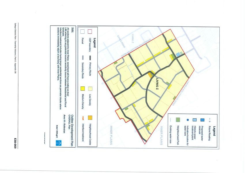
Contents

1.      INTRODUCTION .......................................................................................................................... 1
2.      PLAN CHANGE 7 ......................................................................................................................... 2
3.      LAND USE RECOVERY PLAN - ACTION 18 OUTLINE DEVELOPMENT PLANS............................... 4
       3.1         Rolleston Greenfield Development Areas ..................................................................... 4
4.      DEVELOPMENT CONSTRAINTS ................................................................................................... 6
       4.1         Multiple Ownership Within Outline Development Plans .............................................. 6
       4.2         Infrastructure ................................................................................................................ 7
       4.3         Development Potential Within ODP’s ........................................................................... 8
       4.4         Outline Development Plan Area 4 - Summary ............................................................ 11
       4.5         Outline Development Plan Area 9 - Summary ............................................................ 14
       4.6         Outline Development Plan Area 10 - Summary .......................................................... 17
       4.7         Outline Development Plan Area 11 - Summary .......................................................... 20
       4.8         Outline Development Plan Area 12 - Summary .......................................................... 23
       4.9         Outline Development Plan Area 13 - Summary .......................................................... 26
       4.10        Summary of Development Constraints ....................................................................... 28
5.      CONCLUSION............................................................................................................................ 29

Appendices

Appendix 1 – Plan Change 7 Outline Development Plans

Appendix 2 – Action 18 Outline Development Plans

Appendix 3 – SDC Indicative Infrastructure Staging Plan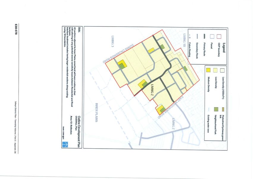
1.      INTRODUCTION
Growth within the Selwyn District is not a new phenomenon. A simple ‘google’ search unearths the
following headlines which are typical when the words ‘growth’ and ‘Selwyn’ are mentioned in the
same sentence.

      Selwyn is the fastest growing district in New Zealand for the seventh year in a row –
      Fairfax Media
      Our district has been the fastest growing district in New Zealand over the past decade
      and is also experiencing the strongest economic growth in New Zealand. - Sensational
      Selwyn
      Selwyn district was the fastest-growing territorial authority area (2006-2013), increasing
      by a third (10,953 people) to 44,595. – Statistics New Zealand
      Strong population, employment and GDP growth again cemented Selwyn District’s
      number ranking in BERL’s 2013 review of the economic performance of the nation’s
      regions – Business and Economic Research Limited (BERL)

The influence of post-earthquake population movements, associated infrastructure developments,
the rural sector and local employment opportunities continue to underpin Selwyn’s growth.
Selwyn’s ability to accommodate this growth from a residential perspective is largely down to the
influence of two resource management instruments, namely Plan Change 7 (PC7) and the Land Use
Recovery Plan (LURP) along with the favourable ground conditions and newly commissioned Eastern
Selwyn Sewer Scheme.

Of significance to this report is the decisions emanating from both PC 7 and the LURP and their
influence on current and future growth within Selwyn but more particularly Rolleston. These
influences will be discussed in the following sections of this report.

                  Map 1: Rolleston Planning Zones, also showing LURP Priority Areas

Rolleston Residential Growth Report, April 2015                                                    1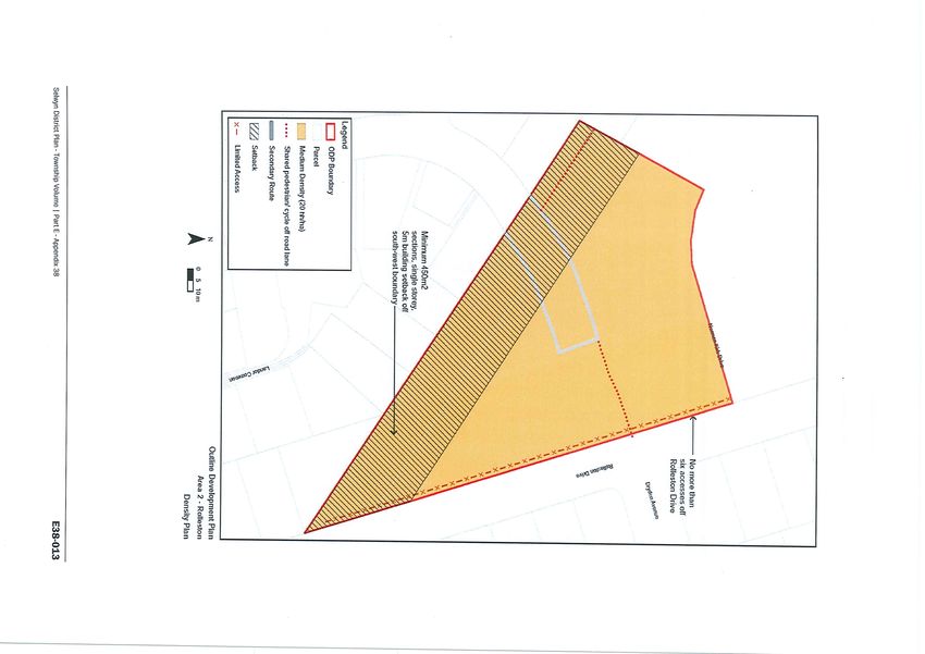
2. PLAN CHANGE 7
The genesis for Council’s Plan Change 7 lay within the Greater Christchurch Urban Development
Strategy which was released in 2007. The purpose of this strategy was to introduce an integrated
approach to urban growth across the Greater Christchurch area through a collaborative process
which included the Selwyn District Council, Waimakariri District Council, Christchurch City Council,
Environment Canterbury, New Zealand Transport Agency and Te Runanga Ngai Tahu.
Plan Change 7 was titled Growth of Townships, Urban Development and Implementation of the
Lincoln & Rolleston Structure Plans and was described as A Proposed Plan Change to provide for the
strategic residential growth of townships and to introduce new subdivision and medium density
provisions. A draft Plan Change was released in 2009, it was notified and 2010 and finally adopted
by Council in 2010. Following an appeals process the provisions within Plan Change 7 were made
operative in September 2011.
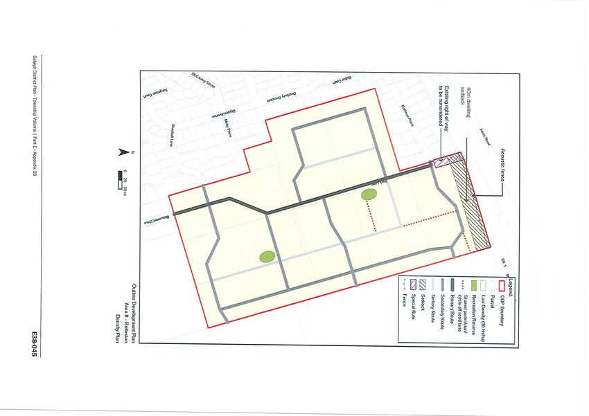
Within Rolleston, Plan Change 7 rezoned and approved ODP’s for the following areas:
ODP Area 1 – West Rolleston
ODP Area 2 – SDC owned land adjoining Markham Way
ODP Area 3 – East Rolleston
ODP Area 6 – South Rolleston
ODP Area 7 – North Rolleston
ODP Area 8 – North East Rolleston
The headline growth within Selwyn post-earthquakes in so far as Rolleston is concerned has been
concentrated within the ODP areas above. A summary of development within these areas in
provided below (based on SDC Monitoring figures supplied 25/03/15):
ODP Area 1
Area 1 is comprised of land within the Stonebrook and Newman Park residential
subdivisions. Selwyn have identified an allocation of 633 lots within this area. Current
records indicate 672 lots have been consented with 224c certification being issued for just
under half of these. The Stonebrook development appears to be progressing at a rate
commensurate with Rolleston growth, however the Newman Park development seems to
be experiencing slow growth/uptake.
ODP Area 2
Area 2 is a small triangular piece of land bounded by Rolleston Drive and Norman Kirk Drive
which is owned by the Selwyn District Council. It is understood that this land is likely to be
used for commercial purposes as part of the Town Centre Masterplan.
ODP Area 3
This area consists of the Lloyd Park, Levi Park and Devon Park residential subdivisions.
Selwyn have identified an allocation of 484 lots within the area. Current records indicate
456 lots have been consented with 224c certification being issued for 286 lots. Both Lloyd
Rolleston Residential Growth Report, April 2015 2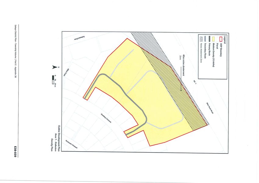
Park and Levi Park have sold out. Levi Park construction and residual 224c certification
represents the lag between sales and issue of title and settlements. Devon Park was the last
development within this ODP to commence and therefore progress is well behind the
balance of the ODP.
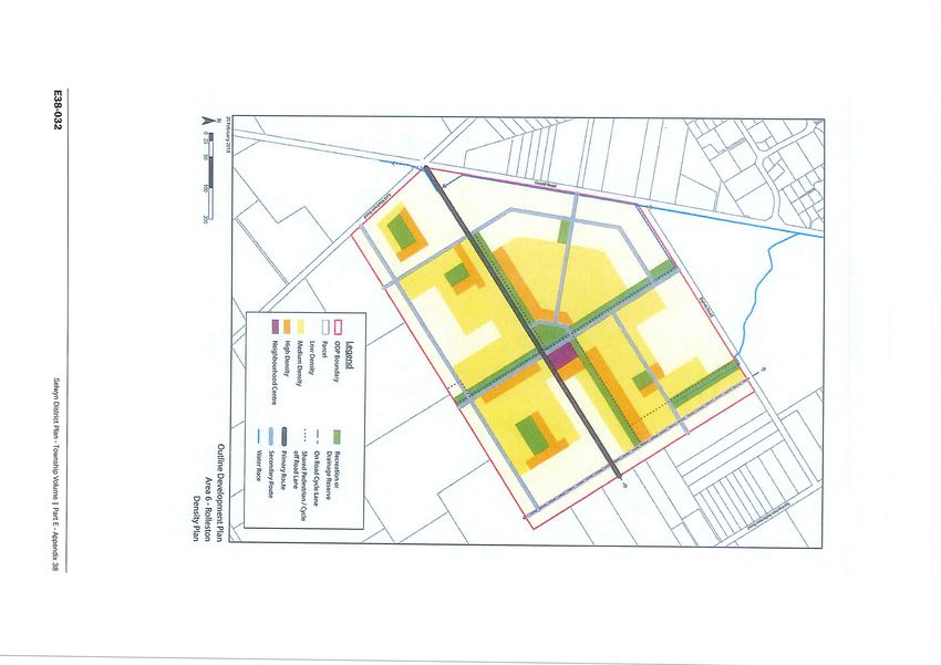
ODP Area 6
The area consists entirely of the Faringdon subdivision. To date consent has been issued for
873 lots, with 224c certification issued for 791 lots. Subdivision consent for 105 lots within
the final stage of Faringdon is due to issue this week.
ODP Area 7
This is a single development area which is known as Park Grove. The area has a capacity of
69 lots which have all been consented. Only 9 lots have received 224c certification.
ODP 8
This area contains the Park Lane, Mayfair (further stages) and Beaumont Park subdivisions.
The area has an allocation of 330 lots, all of which have been consented. Section 224c
certification has been issued for 152 lots. This area is slightly different to other ODP areas in
that consent was obtained for the entire area by one developer/landowner on behalf of the
other landowners. This developer has developed 2 of the 8 sites within the ODP. An
additional 3 sites have been separately developed in accordance with the consent. A further
two sites have recently been acquired and the developer has amended the consented layout
for the underlying sites. This development is under construction with a 224c application due
to be made within the next 3 weeks. One site (4ha) located centrally within this ODP,
remains undeveloped.
ODP ALLOCATION CONSENTED 224C ISSUED
1 663 672 323
2 - - -
3 484 456 286
6 996 873 791
7 69 69 9
8 330 330 152
A copy of each of the outline development plans (plan only) is contained within Appendix 1 attached.
As the summary table above attests, the ODP Areas created through PC 7 have been extensively
developed. Whilst there is difference between consented lots and those with 224c certification, this
differential will be due to a number of factors including staging, construction programmes, pre-sales
and market up-take. Also contributing to this difference will be comprehensive developments
whereby 224c cannot be issued until dwellings have been constructed to a point beyond their pre-
line inspection.
When considering Plan Change 7 was made operative in 2011 the table above also highlights the
speed at which development has progressed in Rolleston. Furthermore it is worth highlighting that
the three largest ODP areas (1, 3 & 6) have been the most progressive. This is almost certainly
attributed to the fact that the three areas in question were large greenfield blocks in single (or
limited) ownership, whereby the majority of development was undertaken by large-scale
experienced developers (Gillman Wheelans; CDL; Hughes Developments).
Rolleston Residential Growth Report, April 2015 3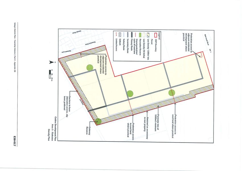
3. LAND USE RECOVERY PLAN - ACTION 18 OUTLINE DEVELOPMENT PLANS
The LURP is a statutory document which directs the Christchurch City Council, Waimakariri and
Selwyn District Councils and Canterbury Regional Council (Environment Canterbury) to make
changes to district plans, the Canterbury Regional Policy Statement and other statutory documents.
The release of the LURP in December 2013 contained a number of Actions which directed the extent
of changes that were considered necessary to give effect to the Recovery Strategy.
Of relevance to Selwyn District Council was Action 18 within the LURP. Action 18 (i) to (vii) identifies
seven greenfield priority areas for future residential development. The Council has developed
Outline Development Plans through an extensive consultation process with landowners, affected
parties and stakeholders. The ODPs have been developed in accordance with best practice urban
design and subdivision criteria and are intended to facilitate the provision of up to 4,500 additional
residential sections to meet growth through to 2028 in the Selwyn District.
3.1 Rolleston Greenfield Development Areas
The LURP identified six greenfield development areas in Rolleston, comprising:
Area 4 Corner Lincoln Rolleston/Levi Roads (7.2ha)
Area 9 Helpet Park (25ha)
Area 10 Triangle Block (31ha)
Area 11 Branthwaite Drive (151ha)
Area 12 West Block (87ha)
Area 13 Springston Rolleston Road (36ha)
The preparation of ODPs for each of these greenfield priority areas creates the planning framework
for guiding future residential development. The LURP seeks clear planning and design requirements
for greenfield development through the use of ODP’s. The ODPs seek to provide:
A range of low-medium density housing options
Strong transportation links and a range of transportation mode options
Neighbourhood parks
Environmental and cultural values
Land stability and contamination considerations
Infrastructure capacity considerations
The ODP’s are structured to address the anticipated density within each area and the manner in
which it is to be achieved. The ODP’s also address the movement network, green network and blue
network which relate to roading, pedestrian and cycling connectivity, the recreation reserve network
and infrastructure capacity respectively.
It is interesting to note that the collective area of the respective Rolleston ODPs equates to 337ha
(whilst the Prebbleton ODP Area 3 has an area of 15ha). All of these areas have a prescribed
minimum density of 10 households per hectare which equates to a minimum yield of 3,533
households from the greenfield priority areas. This represents a shortfall of 978 between the
minimum density achievable and the intention to provide up to 4,500 additional households through
Rolleston Residential Growth Report, April 2015 4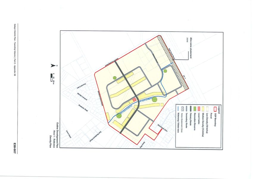
to 2028. Whilst it is acknowledged that the density requirement is a minimum, the collective
greenfield areas would need to develop at a minimum density of nearly 13 households per hectare
in order to attain the 4,500 households.

A copy of each of the outline development plans (plan only) is contained within Appendix 2
attached.

Rolleston Residential Growth Report, April 2015                                              5
4.      DEVELOPMENT CONSTRAINTS
Since the Rolleston ODP areas were made operative in December 2014, a very limited extent of
development has ensued. A joint landowner/developer project within ODP 9 encompassing two
sites has obtained consent for a 48 unit lifestyle retirement village. Within ODP 12 a subdivision of
19 lots has been approved on a 3.34ha site fronting East Maddisons Road, and an application for 31
lots on an adjoining 3.5ha site is currently being processed by Council. Although not a residential
activity, it is also worth noting that within ODP 13 consent has been issued for a Christian Primary
School.

In respect of the development within ODP 9, the two sites which form part of the development
could be considered the two most optimal development sites within the ODP. They are the only two
adjoining sites where the existing residential dwellings are located to the rear, thereby freeing up a
suitably sized area of land available to be further developed. In addition, the sites have direct
frontage to Lowes Road. No other sites within this ODP exhibit these characteristics in combination.

The sites which have been or are subject to subdivision development within ODP 12 are located in
the direct vicinity of the area identified within Phase 2 of the Indicative Infrastructure Plan. All other
sites within this ODP lie within Phase 3 or 4.

The level of development activity above is indicative of how optimal development conditions and
circumstances can facilitate growth. Conversely it paints a clear picture of how less than ideal
development conditions will also stall and constrain growth.

The ODP areas identified within Action 18 are subject to a series of development constraints which
are likely to limit the effectiveness of these areas as a response to the recovery. Independently and
collectively these constraints directly impact on the suitability of land within the ODP’s to meet
Rolleston’s residential growth requirements. These constraints are discussed in more detail below:

4.1     Multiple Ownership Within Outline Development Plans

Of the six ODP’s identified within Action 18, five of them are comprised of multiple landowners (21-
31 separate owners). Although the total land area (and size of landholdings) within each of the
ODP’s varies multiple ownership of land within ODP’s creates a number of constraints to
development. These include:

Rolleston Residential Growth Report, April 2015                                                         6
4.1.1   Piecemeal development
Of the 123 landowners within the six ODP areas, 73 (60%) landowners participated in the
consultation process and lodged submissions within Council. Whilst it is uncertain how much of this
60% are further motivated to develop, it is not unreasonable to assume that land available to be
developed (or not) will be sporadically distributed within ODP areas. This gives rise to the following
implications:

a.      Inefficient infrastructure solutions can often arise when designs are underpinned by ‘one-
        off’ developments but have to incorporate adjoining sites into designs.
b.      Often designing for a wider area results in the ‘first cab off the rank’ being forced to carry
        the up-front ‘head costs’. This becomes burdensome if adjoining sites are not developed in
        a timely fashion and these costs are forced to be absorbed over a long period.
c.      Unless a cluster of landholdings is developed concurrently, vehicle and pedestrian (and
        cycle) connectivity between sites will not be possible, effectively resulting in a series of cul
        de sac developments.
d.      The ODP’s will dictate where reserves are to be located. This could be in area that doesn’t
        get developed; conversely a piecemeal development pattern may preclude access and good
        connectivity to reserves.
e.      Alternative funding options to assist with a comprehensive infrastructure solution are
        available however such options which seek to ease the burden on the landowner/developer
        are likely to transfer this burden to Council. As this issue transcends one ODP and relates to
        all but one of them, this has significant financial implications.
4.1.2   Cross-Boundary Issues
a.      A large majority of sites within these ODP’s contain extensive shelterbelt planting. Cross
        boundary issues around the retention of such planting are likely to arise when one
        neighbour seeks to develop and the other(s) don’t.
b.      Roads within ODP’s often straddle or extend along a shared boundary. A developer may be
        forced to carry the full cost of roads but is not able to derive the full benefit from them until
        such time as the neighbour decides to develop (if ever ?). Alternatively a half road gets built.
c.      Should a landowner seek to realise the development potential of their land but have no
        propensity to develop themselves, the only alternative is to dispose of land to a developer.
        Given the size of landholdings within the ODP’s developers are likely to seek out a critical
        mass of land to make development feasible. For this to occur, developers can either slowly
        aggregate land until such time as they achieve a critical mass or landowners can collaborate
        and look to offer a collective land package for sale. Current experience suggests that this
        collective approach is fraught with difficulty (around contractual terms, distribution of
        yield/equity, apportionment of costs etc…) whilst the aggregation of land also presents
        difficulties given the number of parcels potentially required to achieve the necessary critical
        mass.

4.2     Infrastructure

Rather surprisingly the existing wastewater network only has capacity to service ODP 9 and small
pockets of ODP’S 10 and 12 (and potentially ODP 7) within the immediate future. The balance of the
ODP’s require significant network infrastructure investment before residential development can

Rolleston Residential Growth Report, April 2015                                                        7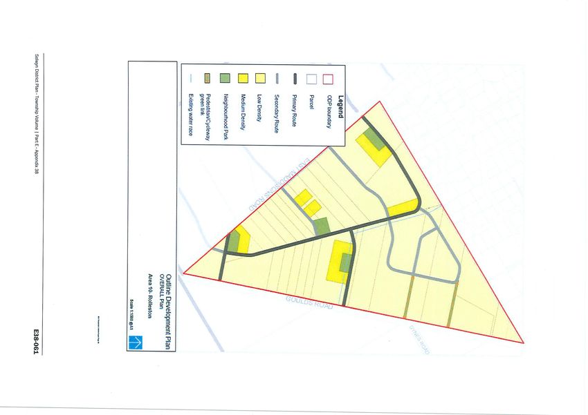
even be contemplated. An indicative infrastructure staging plan (refer Appendix 3) prepared by
Council to assist with the programming of this investment recommends four phases spanning the
period 2014-2030 for the provision of the necessary infrastructure to support the ODP’s identified
within Action 18 of the LURP.

The Draft 2015-2025 Long Term Plan identifies infrastructure investment allocated to Springston
Rolleston Road Main Sewer ($1,830,000) and the West Faringdon Main Sewer ($720,000).
Discussions with Council’s Strategic Asset Manager Utilities have crucially identified that the
provision of this network infrastructure is not the ‘panacea’ for the infrastructure constraints
confronting these ODP areas. Significant internal infrastructure will still be required before the large
majority of these ODP’s can be adequately serviced. Alongside the provision of this network
infrastructure will be the requirement for considerable design coordination which will be the
responsibility of developers within the respective ODP areas.

This design coordination poses a further constraint to development for there will be a high level of
interdependency between sites in respect of access to the infrastructure network. For example,
Council is extending their sewer network to connect with ODP 12 in the south eastern corner of the
ODP in the vicinity of the East Maddison/Goulds Road intersection. Accordingly access to the
network will only be available as development proceeds in a northerly direction originating from the
south eastern corner. Alternatively within ODP 11, sites located along Lincoln Rolleston Road or
Branthwaite Drive cannot contemplate developing until such time as those lots fronting Springston
Rolleston Road have been developed.
As discussed within the issue of multi-ownership above, it is not inconceivable that one or a series of
landowners who are not motivated to develop can stymie the development intentions of others
within an ODP area.

4.3     Development Potential Within ODP’s

To state the obvious, before a site can be developed for residential purposes, the owner must first
be motivated to either develop themselves or on-sell to a developer. A number of significant
implications arise from this simple premise, firstly from the landowner’s perspective:
a.      All of the sites contained within the six ODP’s are rural residential or rural lifestyle in
        character. The occupants chose to reside on these sites specifically for their rural residential
        or lifestyle characteristics. To assume that due to the zoning being changed the level of
        enjoyment derived from the sites is diminished is somewhat flawed, especially given the
        level of investment evident within these sites. It could be argued that the zone change will
        increase the value of the site to such an extent that financial gain assumes priority over
        lifestyle. However, this train of thought is not cognisant of the uniqueness of this situation.
        Due to very strict directions contained within the RPS and the LURP around rural residential
        development, sites exhibiting characteristics such as these (5,000m2 – 2ha) which are so
        conveniently located to the growing range of urban services within Rolleston are likely to
        become very rare.
        Likewise, a similar scenario applies for the rural lifestyle (4 hectare) blocks within the ODP
        areas. Having such sites located on the immediate doorstep of a developing urban area with

Rolleston Residential Growth Report, April 2015                                                       8
growing commercial, community, recreation and educational services makes them unique.
The impact of which is to make them sought after and/or hard to surrender.
Finally the uniqueness of these sites and the demand for them in their current state as
opposed to their future potential will positively influence their value. Whilst residential
zoning may add value, these sites are likely to appreciate on their own, thereby providing a
risk free means of attaining capital gain which is yet another factor that may constrain the
availability of this land for residential purposes.
b. Should the financial lure of residential development be contemplated, landowners must first
decide whether they themselves have an appetite for development. This will require
acceptance of the risks associated with development including the significant capital outlay,
the timeframe before registering returns, management of the development process and
vulnerability of land development to a wide range of factors (market fluctuations,
construction costs, weather delays, consent and compliance matters, contamination and
geotechnical conditions etc….).
If landowners do not have an appetite to develop themselves, the alternative is to on-sell to a
developer. The implications of this from the developer’s perspective include:
a. Whilst these areas are referred to as ‘greenfield’ areas, they are not in the strictest sense
greenfield sites for most of them contain dwellings and varying levels of built improvements.
Given the capital cost of dwellings, the option of demolition is not likely to be feasible in the
majority of circumstances. This therefore requires the existing dwellings to be incorporated
into layout designs. This can often prove difficult due to having to manipulate road frontage
to fit existing access configurations to the dwelling (e.g. garaging) and due to the large and
established curtilage areas that are often retained around such dwellings. The location of
the dwelling (plus curtilage) on sites (in relation to boundaries) can also be influential on
overall layouts, section shapes and sizes.
b. As mentioned in the analysis above, attaining a critical mass is a key component in assessing
the viability of a land development opportunity. Given the size of landholdings within the
ODP areas, acquiring sufficient contiguous land parcels to make development feasible will be
essential (and difficult). Without a contiguous critical land mass, offsetting key aspects of
development such as:
- Insurances
- Health and Safety
- Contractor Set Up Costs
- Cost of funds
- Cashflow management (offsetting deposits and settlements against progress
payments etc…)
It becomes nigh on impossible to create a financially viable project.
c. A critical aspect when acquiring land for development is the price of the land. The cost of
land is one of the largest development costs and consequently directly impacts on the
viability of development prospects.
Rolleston Residential Growth Report, April 2015 9In undertaking development feasibility, developers often use a formula to calculate a
residual land value. This is achieved by forecasting a net realisation figure and subtracting
from this the cost of development (fees, construction, DCN’s, marketing, legals, holding
costs etc…) and a profit and risk margin.
In situations where land zoning changes it often creates an unrealistic expectation as to the
impact on land value. This is often exaggerated in times of high growth. If land becomes
over-valued or is priced too high, one of two outcomes will eventuate. Either the developer
has to adjust the realisation figures to offset the inflated land value or the land cannot be
acquired.
In the current situation within the ODPs whereby development cannot be commenced in a
timely fashion, the additional cost of holding land that can be acquired needs to be factored
into the formula as a higher cost of development. The ‘knock on’ effect of this is either a
higher realisation forecast or the development becomes unviable and the land is not
acquired.
When factoring all the aforementioned matters that could impact on development, it becomes
clearly evident how the cycle of constraints emanating from these ODP areas limits their
development potential and therefore their potential to meet Rolleston’s residential growth needs.
The following sections summarise each of the ODP areas more specifically in terms of their
development potential.
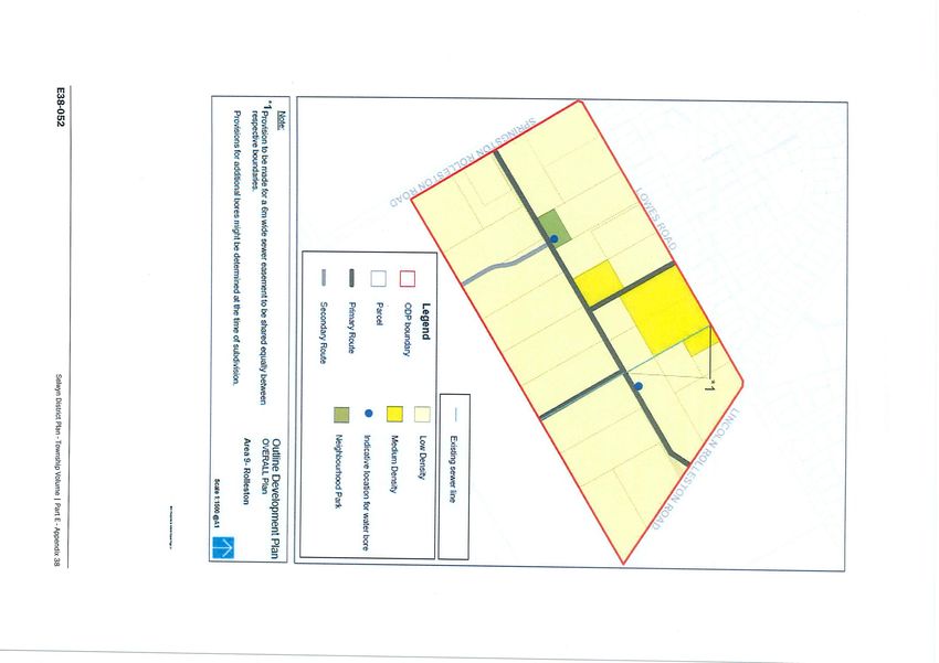
Rolleston Residential Growth Report, April 2015 104.4 Outline Development Plan Area 4 - Summary
The following is a summary of existing and potential development within ODP Area 4:
Existing Area
Total area of ODP: 7.1831 hectares
Number of landowners: Single ownership
Existing development: Mainly paddocks and open land with one dwelling and two non-
residential buildings.
Map 2: Aerial of ODP 4 from Canterbury Maps
Summary of District Requirements
Location
ODP Area 4 is bound by Levi Road to the north-west and Lincoln Rolleston Road to the south-west.
Density
The ODP area shall achieve a minimum of 10 household lots per hectare.
Anticipated yield: 71 households.
Lower density allotments with a minimum lot size of 1,000m2 are necessary on the eastern
boundary to integrate the site with the adjoining rural properties that are subject to the
Rural (Inner Plains) zone and to achieve a progressive transition between residential and
rural densities.
Rolleston Residential Growth Report, April 2015 11 The area‘s proximity to the town centre and its associated services and facilities supports
some Medium Density Housing within the centre of ODP Area 4 and in proximity to the
identified Neighbourhood Park.
Movement Network
The ODP provides for an integrated transport network incorporating a secondary loop road
that includes two primary connections to access the development area from Lincoln-
Rolleston Road, which have been offset from the primary route required in the adjoining
ODP Area 9.
Primary connections into the development block from Levi Road have been restricted to
reflect Levi Roads arterial function, to minimise the number of new intersections and
connection points and to maintain appropriate spacing between intersections.
The intersection of Lowes, Levi and Lincoln-Rolleston Roads and Masefield Drive is planned
to be upgraded with a larger roundabout.
Roads with a current speed limit over 70km/h will be reduced to support urban
development by delivering a safe and efficient transport network.
Green Network
A single Neighbourhood Park is to be established plus a range of local reserves that vary in
size and function.
There is an opportunity to integrate the collection, treatment and disposal of stormwater
with open space reserves where appropriate.
Pedestrian and cycle paths to integrate into the open space reserves and green links to
ensure a high level of connectivity is achieved, and to maximise the utility of the public
space.
Blue Network
Stormwater - The underlying soils generally support the discharge of stormwater via
infiltration to ground. There are a range of options available for the collection, treatment
and disposal of stormwater. Detailed stormwater solutions are to be determined by the
developer at subdivision stage and in accordance with Environment Canterbury
requirements. Systems will be designed to integrate into both the road and reserve
networks where practicable. The public stormwater system will only be required to manage
runoff generated from within the road reserve.
Sewer – A gravity sewer connection will be required through an extension to the existing
sewer network to the boundary of the ODP area. Sewage from this ODP area will be
reticulated to the existing Helpet sewage pumping station.
Water - The water reticulation will be an extension of the existing water supply in Rolleston.
Development Potential
Although being in single ownership is of considerable benefit, a number of constraints preside within
ODP 4 that will limit the potential yield from this area. These include:
The site is triangular in shape which poses some layout and shape factor challenges
Rolleston Residential Growth Report, April 2015 12 The requirement for 1000m2 (min) sites along the western boundary will considerably
impact on the overall yield from the site given the relatively small residual area left to offset
this low density
Access to the site from the existing road network in the proximity of the Levi Road/Lincoln
Rolleston Road roundabout may be problematic, especially given the increased priority of
Levi Road following the completion of CSM2.
The existing dwelling and curtilage will impact on layouts and yield
Although ODP 4 falls within the Stage 2 infrastructure phase, given its proximity it may be possible
for the site to be serviced by the existing infrastructure network.
Rolleston Residential Growth Report, April 2015 134.5 Outline Development Plan Area 9 - Summary
The following is a summary of existing and potential development within ODP Area 9:
Existing Area
Total area of ODP: 24.81 hectares
Number of landowners: 24
Existing development: 24 dwellings i.e. one dwelling per title, most with garages plus one
non-residential building. The majority of dwellings are centrally
located within their sites, accessed via a long driveway.
Map 3: Aerial of ODP 9 from Canterbury Maps
Summary Of District Plan Requirements
Location
ODP Area 9 is bound by Lowes Road to the north, Lincoln Rolleston Road to the north-east and
Springston Rolleston Road to the south-west.
Density
Minimum of 10 household lots per hectare required.
Possible yield: 248 households.
ODP9 predominantly provides for low density sections with specific areas for Medium
Density housing allocated to areas that are suited for comprehensive Medium Density
housing, such as senior living and retirement villages.
Rolleston Residential Growth Report, April 2015 14Movement Network
The ODP employs a roading hierarchy based around Primary and Secondary Roads and
possible tertiary roads that deliver a range of integrated transport options, including:
- Primary road connections linking ODP Area 9 to Lowes, Lincoln-Rolleston and
Springston-Rolleston Roads;
- Active transport connections at the boundary of the development area to adjacent
neighbourhoods, including ODP Area 11.
The ODP requires two secondary and one primary route to facilitate an internal north-south
orientated subdivision layout.
Roads have been off-set to avoid a straight through ‘run’ coming from Lowes Road. The
intersection of Lowes, Levi and Lincoln-Rolleston Roads and Masefield Drive is planned to be
upgraded with a larger roundabout.
A shared pedestrian and cycling pathway along the southern side of Lowes Road between
Springston-Rolleston Road and Lincoln-Rolleston Road will continue to extend from the
existing facility from the west as part of the ODP Area 9 development.
Green Network
A single neighbourhood park is to be established.
Foster Recreation Park will provide access to active recreation opportunities.
There is an opportunity to integrate the collection, treatment and disposal of stormwater
with open space reserves where appropriate.
Pedestrian and cycle paths, including specifically the green link between Lowes Road and the
central Primary Road, are required to integrate into the green network.
Blue Network
Stormwater: The underlying soils are relatively free-draining that generally support the
discharge of stormwater via infiltration to ground. There are a range of options available for
the collection, treatment and disposal of stormwater. The public stormwater system will
only be required to manage runoff generated from within the road reserve.
Sewer: A gravity sewer connection will be required through an extension to the existing
sewer network to the proposed allotments. Sewage from this ODP area will be reticulated to
the existing Helpet sewage pump station.
Water: The water reticulation will be an extension of the existing water supply in Rolleston.
Two water bores are required to be established, one within the Neighbourhood Park and the
other north of the secondary roading connection from Branthwaite Drive.
Development Potential
The ODP 9 area is known as Helpet Park. Its location provides a significant advantage over other
ODP areas as it is able to be developed utilising the existing infrastructure network. However many
other development constraints apply to Helpet Park:
The size of the lots, coupled with the position of existing dwellings makes development of
residual land difficult.
All southern lots are currently served by two rights of ways which are held in shared
ownership. Extinguishing the rights of way through the cooperation of all parties, along with
Rolleston Residential Growth Report, April 2015 15ensuring access in maintained (including construction of a new through road) is an added
complexity for all of these ‘rear’ sites.
The value of sites such as this, which are effectively ‘rural residential’ being located centrally
within Rolleston may be prohibitive to future development.
To date, definitive development progress has been made on 2 of the 24 sites. Interestingly the two
sites in question are the only sites with access to Lowes Road, whereby the existing dwellings are
located to the rear, thereby freeing up a critical mass available for development. In light of the
constraints alluded to above, the critical mass was achieved through a joint approach from the
landowners to a third party who is undertaking the development. Highlighting the difficulties of this
methodology is the fact that a third landowner was initially involved but withdrew from
negotiations. It is also worth putting the development into context in terms of critical mass/yield, as
it is a retirement lifestyle development which consists of a higher residential density than regular
residential development. This ‘zero-lot’ development method retains ownership of infrastructure
(as opposed to vesting) which provides design flexibility and assists with higher densities and
managing construction costs.
Rolleston Residential Growth Report, April 2015 164.6 Outline Development Plan Area 10 - Summary
The following is a summary of existing and potential development within ODP Area 10:
Existing Area
Total area of ODP: 31.04 hectares
Number of landowners: 21 owners on 28 titles
Existing development: approx. 24 dwellings, most with garages plus a number of large
non-residential buildings. All have paddocks and most dwellings are
set back from the road/boundary of their ownership. A small
number of the titles are not built on.
Map 4: Aerial of ODP 10 from Canterbury Maps
Rolleston Residential Growth Report, April 2015 17Summary of District Plan Requirements
Location
ODP Area 10 is bound by Goulds Road to the east and East Maddisons Road to the west.
Density
The ODP area shall achieve a minimum of 10 household lots per hectare.
Possible yield: 310 households.
Provides for both low density and medium density housing options.
Movement Network
The ODP provides for an integrated transport network incorporating:
- A primary route that follows a north-south alignment that is supported by two east-west
orientated connections onto Goulds and East Maddisons Roads;
- active transport connections at the boundary of the development area from East
Maddisons and Goulds Roads to adjacent neighbourhoods;
- pedestrian and cycle corridors and connections.
Three connections from the internal Primary Road integrate the transport network for
ODP10 with Goulds and East Maddisons Roads. This Primary Road provides a “spine road”
that provides primary connections onto East Maddisons and Goulds Roads respectively.
The position of the intersection of this Primary Road with Goulds Road must be located
directly opposite the entrance road into the Faringdon subdivision.
The southern portion of East Maddisons Road will be realigned to reduce the number of
roads that are served by the Goulds Road intersection.
Goulds Road will be closed to vehicular traffic south of Lowes Road and a walking and cycling
link will be established to provide the necessary connections to the nearby community
facilities.
Two secondary routes provide a link between the primary “spine road” and East Maddisons
Road.
A North East secondary loop road provides connectivity and access to future development in
an area that cannot be accessed off Goulds Road.
Two shared off-road green link pedestrian and cycle connections to Goulds Road connect to
Faringdon and the Recreation Precinct.
It is anticipated that roads with a current speed limit over 70km/h will be reduced to support
urban development by delivering a safe and efficient transport network.
Green Network
Four Neighbourhood Parks are required
The adjoining Foster Recreation Park provides access to active recreation opportunities.
Medium Density Housing is to be located immediately adjacent to Neighbourhood Parks to
compensate for the reduced private open space available.
There is an opportunity to integrate the collection, treatment and disposal of stormwater
with open space reserves where appropriate.
Pedestrian and cycle paths, including specifically the two green links between the secondary
loop road and Goulds Road to the east are required.
Rolleston Residential Growth Report, April 2015 18Blue Network
Stormwater - The underlying soils are relatively free-draining that generally support the
discharge of stormwater via infiltration to ground. There are a range of options available for
the collection, treatment and disposal of stormwater. The public stormwater system will
only be required for runoff generated from within the road reserve.
Water race - An existing water race generally follows a portion of the primary road in a
north-south and then east-west alignment where it reaches Gould Road. There is an
opportunity to incorporate the water race into the road design by enhancing its appearance
and establishing it as a feature.
Sewer – A gravity sewer connection will be required through an extension to the existing
sewer network to the boundary of the ODP area. The area immediately adjacent to the
Dynes and Goulds Road intersection is currently able to connect, via gravity, to the existing
pumping station on Goulds Road. However, the vast majority of the ODP Area will need to
reticulate to the new Eastern Selwyn Sewerage Scheme pump station on Selwyn Road via a
sewer connection through the adjoining Faringdon subdivision.
Water - The water reticulation will be an extension of the existing water supply along East
Maddison and Goulds Roads. If required, an additional bore could be established within the
site.
Development Potential
For a block of this size (31ha), there is a high proportion of individual landowners, a matter that is
exacerbated by the unusual shape of many of the parcels (being very long and skinny). Other
relevant factors include:
Much of the ODP area is slated for infrastructure investment in phase 3 (2018-2023),
although a small proportion does sit within phase 2.
For a relatively small development area, there is a large roading component shown on the
ODP coupled with considerable roading upgrade investment required in the southern block.
Sites within the ODP can be categorised as being one of two types, larger (1.2ha – 4.2ha)
with limited built improvements and extensive open areas or smaller (0.4ha-1.2ha) with
considerable built improvements and very limited open areas. The distribution of these sites
is also somewhat uniform, with the larger sites ‘bookending’ the ODP to the north and
south, with smaller sites confined to central areas.
This area presents some issues predominantly around the coordination of development. It is
understood that landowners are polarised as to their development intentions. Accordingly,
achieving a critical mass of land suitable for development may be difficult and development is likely
to occur in a piecemeal fashion with limited coordination and connectivity.
Rolleston Residential Growth Report, April 2015 194.7 Outline Development Plan Area 11 - Summary
The following is a summary of existing and potential development within ODP Area 11:
Existing Area
Total area of ODP: 146.22 hectares
Number of landowners: 31 owners on 32 titles
Existing development: 32 dwellings, most with garages plus some non-residential
buildings. Large areas of open paddock. All titles are built on and
most dwellings are set back from the road/boundary of their
ownership.
Map 5: Aerial of ODP 11 from Canterbury Maps
District Plan Requirements
Location
ODP 11 is bound by Lincoln Rolleston Road to the north-east, Goulds and Springston Rolleston Roads
to the north-west.
Density
10 household lots per hectare.
Possible yield: 1460 households.
Rolleston Residential Growth Report, April 2015 20 Provides for low density sections with specific areas for Medium Density housing options
allocated to areas along the identified Primary and Secondary Roads.
A Neighbourhood Centre of approximately 2,000m2 gross retail floor area is required in a
centralised location of the ODP adjacent to the identified Neighbourhood Park.
Movement Network
The ODP provides for an integrated transport network incorporating:
- Three Primary Road and eight Secondary Road connections providing transport
connections to Springston-Rolleston Road to the south-west, Lincoln-Rolleston Road to the
north-east, the CRETS Road to the south-east and the Broadlands Drive Collector Road to
the north-west
- active transport connections at the boundary of the development area to adjacent
neighbourhoods
- pedestrian and cycle corridors and connections
A Collector Road, identified as part of CRETS (2007 Christchurch, Rolleston and Environs
Transportation Study) is proposed along the south-western boundary of the site. This
Collector Road spans across several neighbourhoods and ODP areas on the southern
boundary of the township.
Lincoln-Rolleston Road and Springston-Rolleston Road provide primary roading corridors on
the periphery of ODP Area 11, which form part of the districts wider arterial roading network
that connects the township to Prebbleton and Christchurch to the south and Lincoln to the
east.
The extension and upgrading of Branthwaite Drive provides a primary loop road that
establishes access and connectivity to the future subdivision of the land that currently
accommodates the decommissioned Helpet treatment plant.
A second primary north-south aligned road connects Branthwaite Drive with the proposed
CRETS Collector Road.
An extension of Dynes Road is required to facilitate connectivity along the east-western
alignment.
It is anticipated that roads with a current speed limit over 70km/h will be reduced to support
urban development by delivering a safe and efficient transport network.
Green Network
Seven Neighbourhood Parks are required to be established
A single larger Neighbourhood Park of approximately 4,000-5,000m2 in size located adjacent
to the proposed water reservoir will provide for a wider range of recreational activities
The Foster Recreation Park provides access to active recreation opportunities.
Medium Density Housing is to be located immediately adjacent to Neighbourhood Parks to
compensate for the reduced private open space available for each of the individual
allotments
There is an opportunity to integrate the collection, treatment and disposal of stormwater
with open space reserves where appropriate.
Pedestrian and cycle paths are required to integrate the road network into the green
network.
Rolleston Residential Growth Report, April 2015 21Blue Network
Stormwater - The underlying soils are relatively free-draining that generally support the
discharge of stormwater via infiltration to ground. There are a range of options available for
the collection, treatment and disposal of stormwater. The public stormwater system will
only be required for runoff generated from within the road reserve.
Water race - An existing water race runs through the southern portion of ODP 11. There is
an opportunity to incorporate the water race into the road design.
Sewer – A sewer connection will be required through a new gravity main along Springston-
Rolleston Road to the Eastern Selwyn Sewerage Scheme pump station on Selwyn Road. The
majority of this ODP area will need to reticulate to a new sewer pump station to the
proposed gravity sewer line on Springston-Rolleston Road.
Water - The water reticulation will be an extension of the existing Rolleston water supply. If
required, an additional bore could be established within the site.
Development Potential
This ODP is the largest in land area of the 6 new ODP areas. The area almost entirely consists of
4ha blocks which have been developed as typical lifestyle blocks supporting a variety of active
and passive rural activities. Each 4ha block contains a large residential dwelling surrounded by
generous curtilage area. Extensive and well-established boundary planting is prevalent
throughout the entire area. Constraints to development within this area include:
Almost three quarters of this ODP area lies within phase 4 of the infrastructure staging plan.
Although the programmed investment for the sewer main along Springston Rolleston Road
to the Radar pump station (Selwyn Rd) will assist in servicing a portion of the ODP,
significant internal (private) infrastructure and design coordination is still required to
support any development within this ODP.
A further potential factor that may impact on the future development of this area will be the
propensity for landowners to want to develop. These blocks have and will become very
unique given their ‘rural’ characteristics within what is now becoming an ‘urban’ setting.
Such a combination is rare and as such the capital growth and value of this land may rival its
residential development potential especially when measuring it against the cost and risk
associated with land development.
The roading component within this ODP is significant, especially given the function of some
of the roads. Furthermore many of the road straddle property boundaries. How this roading
cost is to be apportioned is not clear. Should costs lie where they fall, the development
potential of sites will be impacted considerably. Achieving permeability and connectivity will
rely on significant coordination and investment.
Also worthy of a mention is that of the 31 landowners within ODP 11, 11 landowners did not
appear to participate in Council consultation process. Given that potentially a third of
landowners may not be inclined to develop, achieving both critical mass and design solutions
through collective coordination seems improbable.
Rolleston Residential Growth Report, April 2015 224.8 Outline Development Plan Area 12 - Summary
The following is a summary of existing and potential development within ODP Area 12:
Existing Area
Total area of ODP: 87 hectares
Number of landowners: 23 owners on 24 titles
Existing development: 12 dwellings, most with garages plus some non-residential
buildings. Dwellings are typically located in the front portion of the
sites, set back from the road. This creates large open paddocks to
the rear of the dwellings. Large mature shelterbelt planting is
prevalent on the majority of sites.
Map 6: Aerial of ODP 12 from Canterbury Maps
District Plan Requirements
Location
ODP Area 12 is bound by East Maddisons Road to the north-east and Dunns Crossings Road the
northwest.
Rolleston Residential Growth Report, April 2015 23Density
10 household lots per hectare.
Possible yield: 870 households
Predominantly provides for low density sections, although some medium density housing
options have been supported along the Primary and Secondary Roads.
Medium Density lots created must have a consent notice registered on the title stating that
they are subject to the medium density provisions:
- Ability to access future public transport provisions, such as bus routes;
- Access to community and neighbourhood facilities;
- Proximity to Neighbourhood Parks and/or green spaces;
- NW orientation, where possible, for outdoor areas and access off S and SE boundaries
preferred;
- Distribution within blocks to achieve a mix of section sizes and housing typologies; and
- To meet the minimum 10hh/ha density requirement and development yield.
Lower density allotments with an average lot size of 1000m2 are necessary on the north-
western boundary to integrate the site with the adjoining Living 1B zone.
Movement Network
The ODP provides for an integrated transport network incorporating:
- Primary and Secondary Roads linking the East Maddisons Collector Road to the east, the
CRETS Collector Road to the south and the Dunns Crossing Collector Road to the west;
- active transport connections at the boundary of the development area from the Dunns
Crossing Collector Road to the south-west, the CRETS Collector Road to the south-east and
the East Maddisons Collector Road to the north-east to adjacent neighbourhoods;
- pedestrian and cycle corridors
A Collector Road, identified as part of the CRETS (2007 Christchurch, Rolleston and Environs
Transportation Study) is proposed at the southern boundary of the site. This Collector Road
spans across several neighbourhoods and ODP areas.
Three connections from the internal Primary Roads integrate the transport network for ODP
12 with the East Maddisons Collector Road to the north-east, the CRETS Collector Road to
the south and the Dunns Crossing Collector Road to the south-west.
Dunns Crossing Road is to be sealed and upgraded as part of the wider development
requirements.
Two walking and cycling links are proposed between the Secondary Roads in the north-
eastern corner of the development block
It is anticipated that roads with a current speed limit over 70km/h will be reduced to support
urban development by delivering a safe and efficient transport network.
Green Network
Seven Neighbourhood Parks are required to be established
The Foster Recreation Park provides access to active recreation opportunities.
Medium Density Housing is to be located immediately adjacent to Neighbourhood Parks to
compensate for the reduced private open space available for each of the individual
allotments.
Rolleston Residential Growth Report, April 2015 24 There is an opportunity to integrate the collection, treatment and disposal of stormwater
with open space reserves where appropriate.
Pedestrian and cycle paths are required to integrate the road network into the green
network.
Blue Network
Stormwater - The underlying soils are relatively free-draining that generally support the
discharge of stormwater disposal via infiltration to ground. There are a range of options
available for the collection, treatment and disposal of stormwater. The public stormwater
system will only be required for runoff generated from within the road reserve.
Sewer – A gravity sewer connection will be required through an extension to the existing
sewer network to the boundary of the ODP area. A gravity sewer connection to the new
Eastern Selwyn Sewerage Scheme pump station on Selwyn Road will required via a sewer
connection through the adjoining Faringdon subdivision.
Water - The water reticulation will be an extension of the existing Rolleston water supply. If
required, an additional bore could be established within the site.
Development Potential
ODP 12 is located on the western periphery of the Rolleston urban area. This location provides a
number of development constraints:
An extension of key infrastructure into this area is necessary before it can be developed.
The future extension of the infrastructure network will connect with this area in the south
eastern corner.
Extending the network to the (southeast) boundary of the ODP 12 area is only one piece of
the infrastructure puzzle. In order for sites to access the network, a coordinated design
solution will be required (south to north).
As with other ODP areas, the propensity for landowners to want to develop themselves or
on-sell to developers will have a large bearing on how development proceeds. Such is the
nature of this area, it will only take one or two landowners who are averse to developing (or
selling) to frustrate the potential of the wider ODP to be developed residentially.
Rolleston Residential Growth Report, April 2015 254.9 Outline Development Plan Area 13 - Summary
The following is a summary of existing and potential development within ODP Area 13:
Existing Area
Total area of ODP: 38.72 hectares
Number of landowners: 45 titles, 23 landowners
Existing development: 23 dwellings along with numerous outbuildings on the majority of
sites. The area contains extensive and mature boundary planting.
Map 7: Aerial of ODP 13 from Canterbury Maps
District Plan Requirements
Location
ODP Area 13 is bound by Springston Rolleston Road to the north-east, the Foster Recreation Park
and Faringdon subdivision to the west.
Rolleston Residential Growth Report, April 2015 26Density
10 household lots per hectare.
Possible yield: 360 households
ODP Area 13 predominantly provides for low density sections with some medium density
housing options along the Secondary Roads.
Movement Network
The ODP provides for an integrated transport network incorporating:
- Secondary Roads follow a north-western to southern-eastern alignment linking with a
Collector Road to the north-west, the Springston Rolleston Arterial Road to the northwest
and CRETS Collector Road to the south-east
- active transport connections at the boundary of the development area to adjacent
neighbourhoods that facilitate the use of existing and future public transport connections
- pedestrian and cycle corridors and connections
A Collector Road, identified as part of the CRETS (2007 Christchurch, Rolleston and Environs
Transportation Study) is proposed near the southern boundary of the ODP Area. The
Collector Road spans across several neighbourhoods and ODP areas on the southern
boundary of the township.
Secondary Roads will provide footpaths and cycle routes
A Secondary Road runs from the Broadlands Drive Collector Road through to Dynes Road,
then connects to the CRETS Collector Road on the south-eastern portion of the site. This
Secondary Road shares a boundary with the Foster Recreation Park. The proposed Medium
Density allotments could utilise rear service lanes to provide vehicular access, which would
limit the number of access points and utilise the outlook onto the Foster Park.
A secondary loop road supports connectivity for pedestrians and cyclists between the ODP
and the Foster Recreation Park. Roading connections to the adjoining Faringdon subdivision
are provided via the proposed CRETS Collector Road and a Secondary Road.
A single shared pedestrian cycle way comprising a minimum 6m wide green link connects
the Foster Recreation Park to the Secondary Road that connects onto Springston-Rolleston
Road to the north-east of ODP Area 13.
Green Network
Three Neighbourhood Parks are required to be established.
The Foster Recreation Park provides access to active recreation opportunities.
Medium Density Housing is to be located adjacent or in proximity to Neighbourhood Parks
to compensate for the reduced private open space available for each of the individual
allotments.
There is an opportunity to integrate the collection, treatment and disposal of stormwater
with open space reserves where appropriate.
Pedestrian and cycle paths are required to integrate the road network into the green
network.
A 6m wide walking and cycling connection is specifically required between the main
Secondary Road and the secondary loop road off Springston-Rolleston Road.
Rolleston Residential Growth Report, April 2015 27You can also read