STATEMENT OF BASIS ON WHICH THE VICTORIAN ABORIGINAL HERITAGE COUNCIL CONSIDERS IT WOULD BE APPROPRIATE TO VARY THE REGISTRATION AREA OF ...
←
→
Page content transcription
If your browser does not render page correctly, please read the page content below
STATEMENT OF BASIS ON WHICH THE VICTORIAN ABORIGINAL
           HERITAGE COUNCIL CONSIDERS IT WOULD BE APPROPRIATE TO
           VARY THE REGISTRATION AREA OF WURUNDJERI WOI
           WURRUNG CULTURAL HERITAGE ABORIGINAL CORPORATION

           DATE OF PROPOSAL: 7 June 2021

           1        Council’s View
           The Victorian Aboriginal Heritage Council (Council) has formed the view that it would be
           appropriate to exercise its power pursuant to section 155 of the Aboriginal Heritage Act 2006
           (Act) to vary the registration area of Wurundjeri Woi Wurrung Cultural Heritage Aboriginal
           Corporation (WWW). The variation Council considers appropriate relates to some, but not
           all, of an extension of its registration area sought by WWW. 1

           2        Procedural Background of Proposal
           The following section provides a summary of the procedural steps leading to Council’s
           eventual substantive consideration of whether to exercise its power to vary the area of the
           WWW’s RAP application area.

           Council received a written request to vary the registration boundary from WWW in August
           2020. It is to this request that this proposal relates. However, the procedural background to
           consideration of this request involves earlier discussions between WWW and Bunurong
           Land Council Aboriginal Corporation (BLCAC) regarding their respective registration
           boundaries. It is therefore useful to commence by setting out the procedural background
           also to the BLCAC registration boundary variation request.

            In 2017 BLCAC applied to Council for appointment as a registered Aboriginal party (RAP)
           under s 150 of the Act. Council acknowledged receipt of BLCAC’s RAP application on 24
           February 2017. BLCAC’s RAP application was determined for part of the area it applied for
           on 19 July 2017. Council was advised shortly thereafter that BLCAC and Wurundjeri Woi
           Wurrung Cultural Heritage Aboriginal Corporation (WWW) had entered negotiations
           regarding overlapping areas of interest in respect of that part of BLCAC’s application which
           Council had not determined in its favour. These negotiations were facilitated through the
           Victorian Government’s Right People for Country program (RPfC).

           Council acknowledged receipt on 25 September 2017 of correspondence from BLCAC
           advising that all negotiations between the parties had been put on hold, for some 6 to 12
           months, at the request of WWW.

           Council understood that negotiations facilitated by RPfC progressed throughout 2019.

           Council wrote to BLCAC on 17 December 2019 informing it that any unresolved boundary

           1
            Whilst Council has discretion under s.155 to vary the registration area of a RAP of its own motion in practice
           consideration of this discretion to vary also occurs due to a request from the relevant RAP. Council has
           published a policy and procedure to assist RAP’s who make such a request.

OFFICIAL
                                                                                                                             1
registration issues (arising from the 2017 RAP Application) would be resolved pursuant to
           under section 155 of the Act.

           On 23 April 2020 Council gave public notice of BLCAC and WWW negotiations within what
           was described as “the Decision Area” (the area of BLCAC original RAP application that was
           not included in the original BLCAC RAP registration boundary), to seek current views of any
           affected party in relation to the Decision Area.

           Due to concerns regarding COVID-19 during 2020 and the ability of parties to physically
           meet, Council undertook to refrain from making a decision on the BLCAC variation request.

           On 26 August 2020 Council acknowledged receipt of WWW request for variation pursuant to
           section 155 of the Act. It is this request to which this proposal relates. The WWW request for
           variation was divided into three zones. The area referred to as “Zones 1, 1A, 1B, 1C, 1D”
           overlapped the entirety of the BLCAC request for variation.

           Council wrote to WWW on 30 November 2020 advising that as negotiations had been on
           foot between WWW and BLCAC since 2017, continuing through 2019 to date, Council had
           resolved to determine the areas referred to as ‘Zones 1, 1A, 1B, 1C, 1D’ from materials that
           were the outcomes of the RPfC facilitated negotiations.

           Given this overlap, Council had to form a view as to whether and how it should exercise its
           power of variation under s.155. Accordingly, Council wrote to both parties on 13 January
           2021 issuing a direction seeking all material relevant to each party’s respective claims.

           3        Area considered by Council under s.155
           As noted above, Council received WWW’s request for boundary variation pursuant to s 155
           of the Act on 26 August 2020 (Attachment 1).

           The variation request was made up of three zones, namely:

           Zone 1     Melbourne CBD and surrounds; contiguous with the southern boundary of
                      WWW’s current registration area.

                      1A         extends over Melbourne’s inner suburbs and continues in an easterly
                                 direction along the southern boundary of WWW’s current registration
                                 area.
                      1B         extends over Melbourne’s western suburbs to the Werribee River.
                      1C         extends over the Melbourne CBD.
                      1D         extends over Melbourne’s south-eastern suburbs to the northern
                                 boundary of BLCAC’s current registration area and the western
                                 boundary of Gunaikurnai Land and Waters Aboriginal Corporation
                                 (GLaWAC)’s current registration area.

           Zone 2      Hanging Rock and surrounds; contiguous with the north western boundary of
                       WWW’s current registration area.

           Zone 3      Mount Baw Baw Plateau and the Loch Valley, and including Noojee and Neerim
                       East; contiguous with the eastern boundary of the existing RAP area.

           Council has previously advised WWW of a process for dealing with Zone 2. That process
           (involving negotiations with other RAPs is ongoing at this time. As such, Zone 2 is excised
           from the current s.155 variation consideration.

           Council noted correspondence from Gunaikurnai Land and Waters Aboriginal Corporation
           (GLaWAC) dated 20 June 2020 which it provided to WWW on 28 June 2020 and again on

                                                                                                          2
OFFICIAL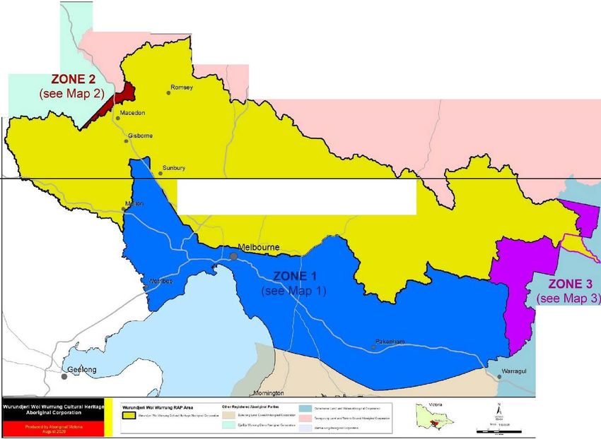
29 January 2021. The correspondence stated that GLaWAC noted that part of the proposed
           boundary negotiation area is still subject to negotiations between GLaWAC and the WWW
           and should not be included in the proposed boundary negotiation area.

           Council noted correspondence from Wadawurrung Traditional Owners Aboriginal
           Corporation (WTOAC) from mid-2020 raising concerns over boundary negotiations between
           WWW and BLCAC overlap with asserted interest of WTOAC over the waters in the west of
           Port Phillip Bay, nearby WTOAC’s RAP area.

           On balance, Council considered it was simplest for the purposes developing of the current
           proposal to excise from this proposal all areas of asserted interest by GLaWAC (relevant to
           Zone 3) and WTOAC (relevant only to waters adjacent to Zone 1) (Attachment 2) depicts
           the current Proposal Area. Council will communicate with affected parties shortly with a
           process of developing a proposal in relation to those areas of WWW’s boundary variation
           request that have been excluded from the current proposal.

           4          Council’s approach to s.155.

           WWW is not a registered native title holder for the proposed boundary variation area within
           the meaning of section 151(2) of the Act, and has not entered into a RSA in relation to the
           Decision Area within the meaning of section 151(2A) of the Act. As such, Council is not
           obliged to approve WWW’’s application over the proposed boundary variation area to align
           with sections 151(2) or 151(2A) of the Act.

           Council has broad discretionary power to make a variation to the registration of a RAP,
           including geographic boundary variations under s 155(2). Section 155 (1) of the Act requires
           the consent of the affected RAP to a variation of its registration boundary. As the boundary
           variation proposed by Council is to vary WWW’s registration boundary to a somewhat lesser
           extent than was sought by WWW it will be necessary for Council to write to WWW to confirm
           WWW does in fact consent to the boundary variation proposed by Council. No other RAPs
           are within the proposed boundary variation area therefore no other consent is required.

           It is clear Council’s discretion to vary a registration area under s.155 must be exercised
           according to law.

           In forming its view about how its discretion should be exercised Council had regard to:
               (a) the overall scheme and purposes of the Act 2.
               (b) the requirements under ss.150 and 151 [in so far as they are relevant to a variation
                   as opposed to a first registration].
               (c) consistent with (a) and (b) Council considered factors such as WWW’s relationship to
                   the undetermined part of the application area including traditional or familial links, its
                   representativeness and inclusivity, any demonstrated expertise in managing and
                   protecting Aboriginal cultural heritage in the area under consideration and its capacity
                   to discharge its statutory functions in general
               (d) the contentions of other interested parties
               (e) Its obligations under the Charter of Human Rights and Responsibilities Act 2006 (Vic)
               (f) Whether WWW is prepared to consent to the variation Council thought appropriate.

           2
               The purposes are set out in s.1 of the Act

                                                                                                            3
OFFICIAL
5. The Material considered
When forming its view as to how its discretion under s.155 should be exercised in this case
Council had regard to the material in Schedule 1 to this Statement.
As the Act also requires Council members to be Aboriginal persons with demonstrable
traditional or familial links to an area within Victoria and have relevant experience or
knowledge of Aboriginal cultural heritage in Victoria (s 131(3)(a) and (c)) Council uses these
attributes when considering the material before it and forming its views. Interested parties
are expressly made aware of this in Council’s publication Section 155 Requests for
Variations of Registration Policy and Procedure.
6. Proposal Area
The following section particularises the area Council considers would be appropriate to add
to WWW’s existing registration area. The relevant area (Proposal Area) is shown in the
attached map (Attachment 2) and is described as:
The Proposal Area is comprised of two parcels. The first and larger Proposal Area is
bounded in the south-west by the Werribee River at the point an extension of Middle
Rd would meet the Werribee River. The Proposal Area continues north-east to
include all of Mt Cottrell at or above 160m above sea level as a shared area with
BLCAC. The Proposal Area extends north-easterly to include the northern face of Mt
Atkinson, then continues in a south-easterly direction to include the localities of Deer
Park, Ardeer, Sunshine, Braybrook and Footscray meeting the original point of
convergence of the Yarra River and the Maribyrnong River. The Proposal Area
extends in a south-easterly direction to include the Docklands area to meet the high
ground in South Melbourne, then extends easterly to include South Wharf,
Southbank and the St Kilda Rd Arts Precinct to the highest point in the landscape at
Government House. The Proposal Area then extends south-east following the
southern-most margin of the Yarra River catchment to include the suburbs of South
Yarra, Prahran, Toorak, Armadale and Malvern. The Proposal Area then follows the
southern margin of the Gardiners Creek catchment to Wheelers Hill and includes the
suburbs of Murrumbeena, Oakleigh, Chadstone and Mount Waverley.
From Wheelers Hill the area extends east across a section of the floodplain of
Dandenong Creek including the catchment of Corhanwarrabul Creek and meets up
with a point on the western margin of the Cardinia Creek catchment at Belgrave
Heights. From this point the decision area follows the south-eastern margin of the
Yarra River catchment and includes the townships of Emerald, Cockatoo and
Gembrook. The Proposal Area extends in a north-easterly direction along the Yarra
River catchment and meets the existing Wurundjeri RAP area at Basan Corner. The
area then extends west and then south west past the localities of Gembrook,
Cockatoo and Emerald following the entirety of the southern margin of the existing
Wurundjeri RAP boundary. At Emerald the Proposal Area tends in a north-westerly
direction to include Mt Dandenong and on to Lilydale. Tending south-westerly,
continuing to follow the existing RAP area to include Mooroolbark, Bayswater and
Camberwell. Continues west following the existing RAP boundary to include the
eastern suburbs and inner-northern suburbs of metropolitan Melbourne and the
entirety of the Melbourne CBD. At St Albans the area extends in a north-westerly
direction and continues to follow the existing Wurundjeri RAP boundary to Mt Aitken.
The area then tends south, following the existing RAP boundary to the start point of
this decision area on the Werribee River. The area does not include zones within the
registration area of any existing RAP.
4
OFFICIALThe second area of proposal begins at the existing RAP area boundary just west of
the northern face of Mt Beenak and extends east to include the catchment of the
Little Yarra River to meet with the boundary of the GLaWAC partial overlap area near
the point known as Spion Kopje. The area then extends north to the existing
Wurundjeri RAP boundary, extends west to include the township of Powelltown, and
continues to follow the existing boundary to meet up with the start point of this
second decision area just west of the northern face of Mt Beenak. The area does not
include zones within the registration area of any existing RAP.
The Proposal Area entirely overlaps:
• asserted interests of BLCAC pursuant to its section 155 variation request lodged in
2017.
• asserted interests of Boonwurrung Land and Sea Council (Aboriginal Corporation)
(BLSC).
5
OFFICIAL7. Material Questions of Fact
Based on the material in Schedule 1 and its own cultural knowledge Council satisfied itself
as to the following material questions of fact in relation to the Proposal Area.
i) Whether WWW represents Wurundjeri Woi Wurrung People
WWW is not a Prescribed Body Corporate under the Native Title Act 1993 (Cth) (NTA).
WWW does not hold native title on behalf of the Wurundjeri Woi Wurrung People and there
are no other native title holders (within the definition of the Act and the NTA) within the
Proposal Area.
Council noted the organisation representing the Wurundjeri Woi Wurrung People’s interests
was called the Wurundjeri Tribe Land and Compensation Council Aboriginal Corporation Inc
during the period from 2009 to December 2018. In December 2018, the organisation was
incorporated under the Office of the Registrar of Indigenous Corporations (ORIC) and
subsequently changed its name.
Council noted that WWW membership is open to all people who identify as Wurundjeri or
Woi-Wurrung and who can establish their descent from those people identified as
Wurundjeri or Woi-Wurrung group members to the satisfaction of the Wurundjeri Council.
Council notes that “Wurundjeri or Woi-Wurrung group members” mean People identified as
members of the following local groups (or as identifiable descendants from earlier members
of such groups) but not limited to:
1. The “Wurundjeri-Balluk”,
2. The “Gunung-Willam-Balluk”,
3. The “Kurung-jang-Balluk”,
4. The “Ngaruk-Willam-Balluk”,
5. The “Balluk-Willam”,
6. The “Marin-Balluk”,
7. The “Wurundjeri-Willam”; and
8. Those identified as members of the Yarra tribe, together with those who can trace
their descent to any identified Woi-Wurrung or Wurundjeri Ancestor.
The WWW Rule Book provides that a fundamental objective of the Corporation is ‘to reclaim
and secure land and compensation through State and Federal Government as a result of the
dispossession and dispersion of the Wurundjeri Tribes and Clans…, to establish a Centre
and Keeping Place for the Wurundjeri Tribe and surrounding clans to maintain Aboriginal
identity and for the protection of cultural heritage…, for the purpose of reinforcing spiritual,
social and cultural contact with the land, to protect and maintain all lands claimed, to compile
a register of sacred and significant sites, and to develop and implement cultural heritage
programs for which the tribal elders shall be responsible.’
Council noted Rule 5.2 (Directors) of WWW’s rule book which states that the directors of the
corporation is not less than three (3) directors and not more that twelve (12) directors. This
number includes officers appointed in accordance with rule 5.8 and up to three (3)
independent or specialist non-member directors appointed in accordance with rule 5.7. To
change the number of directors, members need to pass a special resolution at a general
meeting or AGM to change the rule book. Such a resolution needs to be in the notice calling
that meeting.
On the basis of the information before it, Council was satisfied that WWW is a body
sufficiently representative of the Wurundjeri Woi Wurrung People. Council noted that this
conclusion was consistent with its previous decision of 22 August 2008 to first appoint WWW
as a RAP.
6
OFFICIALii) Whether the Wurundjeri Woi Wurrung People are Traditional
Owners of the Proposal Area
WWW has provided detailed anthropological and historical information that indicates
traditional and cultural links of the Wurundjeri Woi Wurrung People to the Proposal Area.
This information stems from WWW’s own anthropological and historical research, as well as
from material by Alfred William Howitt, George Langhorne, William Thomas Lorimer Fison,
Norman Tindale, Diane Barwick, Edward Brown Addis, Ian Clarke and Robert Hamilton
Mathews. Council commissioned research from Dr Fiona Skyring in 20212 regarding the
greater Melbourne area of which it advised WWW it would consider. Due to the Wurunderji
Woi Wurrung People’s overlapping claims of traditional interests in the Proposal Area, much
of the information is stated in comparative terms between the two groups. Set against the
objectives of the Act and its overall purpose and direction, the Council gives significant
weight to traditional or familial links and considers it an important factor.
Council noted WWW’s anthropological and historical information which provided the
following findings applicable to the Proposal Area:
I. WWW concluded that Alfred Howitt viewed the majority of BLCAC’s boundary
variation request area as Wurundjeri Woi Wurrung territory, except for two narrow
strips of coastline. One section of coastline extended from either the Maribyrnong
River or the Werribee River to Anderson’s inlet and the other is on the eastern coast
of Port Phillip.
II. WWW referred to extracts from Lorimer Fison’s 1890 book The Aborigines of
Victoria. Its reading of the text supports a finding that Wurundjeri Woi Wurrung
People inhabited the boundary variation request area while Bunurong-speaking
groups were confined to the coastal areas on the east coast of Port Philip Bay such
as Mordialloc, Cape Schank, St Kilda and Sandridge.
III. WWW referred to extracts from Robert Hamilton Mathews’ published papers The
Aboriginal Languages of Victoria (1902) and Notes on Some Native Dialects of
Victoria (1903). These writings point to the Woiwurrung language being spoken on
the Yarra, Saltwater and Werribee rivers, and extending from the main dividing range
southerly to the coast at Geelong, Melbourne and Western Port.
IV. WWW also referred to corroborating later or secondary source material including that
of Norman Tindale, Diane Barwick and Ian Clark. WWW concludes that Norman
Tindale’s findings indicate that the entirety of the application was within Wurundjeri
Woi Wurrung territory, save for a section on the eastern coast of Port Phillip Bay from
about Mordialloc to about Dandenong.
V. WWW concluded that Diane Barwick’s findings indicate that the entirety of the
undetermined part of BLCAC’s 2017 application was within Woiwurrung territory,
save for a narrow strip of coast along the west coast of Port Phillip Bay.
VI. WWW puts forth that any findings in the above extracts that conclude that any areas
within the undetermined part of BLCAC’s 2017 application area were Bunurong
territory are incorrect and conflict with contemporary Wurundjeri Woi Wurrung
knowledge.
In contrast Council noted BLCAC’s anthropological and historical information which asserted
the following findings within the Proposal Area:
7
OFFICIALI. At the point of British assertion of sovereignty, Bunurong-speaking groups articulated
identity in terms of coastal water systems such as bays, estuaries and coastal
streams. This can be distinguished from Woiwurrung-speaking groups, who
articulated identity in relation to inland water systems such as the Yarra River
system.
II. In 1835, neither the Bunurong nor the Wurundjeri Woi Wurrung Peoples conceived
boundaries as fixed lines on a map. Boundaries between both groups and individual
clan estates resembled differing areas of exclusive and shared control separated by
boundary corridors, as opposed to firm borders. British settlement further disrupted
the oral transmission of traditional knowledge within the Application Area. Therefore,
a definitive interface between Bunurong and Wurundjeri Woi Wurrung lines of
sovereignty might never be established. However, it is possible to identify what the
cumulative evidence is for each group demonstrating sovereignty in the different
zones of the application area.
III. Based on Alfred Howitt’s conversations with William Barak, it can be inferred that the
Bunurong occupied the coastal regions from the South Melbourne and St Kilda areas
towards Geelong. Howitt’s reports further describe the Bunurong People as
occupying the coast between Werribee River and Anderson’s Inlet.
IV. Writings from contemporary observers such as Daniel Bunce, G Haydon, George
Augustus Robinson and William Thomas point to the presence of known Bunurong
figures in the areas between Werribee and the CBD. These areas lay within the
traditional lands of two Bunurong clans: the Yalukit-willam and the Kurung-jang-
balluk.
V. The extent of the Bunurong Peoples’ exercise of traditional rights and interests in
areas west of the Melbourne CBD reached inland to the sources of Deep Creek near
Mount Cottrell and potentially further.
VI. The early ethnographic record, including Thomas’ and Howitt’s accounts of their
conversations with Barak, indicates a strong Bunurong presence in the Dandenong
Ranges. Barak described the area south and west of the Dandenong mountains as
part of the ‘bad country’ in which Bunurong language was required. The topography
and surface water flows of the region further indicate that the areas west of the
Ranges and within the Patterson River catchment fall within Bunurong country.
VII. Evidence available from the release of Thomas’ journals demonstrates that the
boundary between Bunurong and Wurundjeri Woi Wurrung territory in this area lay
along the ridgelines of the Dandenong mountains. This boundary came down off the
mountains at the junction of Dandenong and Narrawong creeks, a point which lies
roughly at the modern junction of Wellington Road, Rowville and the Eastern
Freeway.
VIII. North of the Dandenong Ranges the creeks and rivers flow into the Yarra, and south
of the Ranges they flow into the sea. This evidence therefore corresponds with
Thomas’ description of river catchments as being a determinant of boundaries
between different groups. Sources recording conversations with William Barak
demonstrate that another section of the boundary between Bunurong and Wurundjeri
Woi Wurrung territory was demarcated by the stretch of Gardiners Creek that runs
from Mount Waverley to its junction with the Yarra River.
IX. Ian Clark’s History of Stonnington indicates that Turruk and Tromgrin, sites situated
between the Royal Botanical Gardens, Melbourne and Gardiners Creek, were on
Bunurong Country.
8
OFFICIALX. The writings of Thomas, Robinson, Howitt and Bunce generally support BLCAC’s
contention that there was a strong Bunurong presence in the eastern parts of the
Application Area. BLCAC believes that the areas lay within the traditional lands of
five Bunurong clans: the Yalukit-willam, the Ngaruk-willam, the Mayone-bulluk, the
Baluk-willam and the Yallock-bulluck.
XI. BLCAC contends that accounts of a Wurundjeri Woi Wurrung presence in the
eastern parts of the Application Area “reads more like that of internally displaced
people, exiled from their home estates” rather than people who actually exercised
traditional rights and interests over the region.
XII. Thomas, John Fawkner and Howitt consistently described the Bunurong People as
coastal and estuarine people. This supports a conclusion that they were associated
with both sides of the Yarra River in its estuarial zone. Bunurong man Derrimut was
consistently described as inhabiting the Melbourne CBD area.
XIII. Sources such as the diaries of Fawkner and Robinson support a contention that the
Melbourne CBD lay within the traditional lands of the Bunurong. In particular, BLCAC
argues that it lay within the clan estate of Derrimut and the Yalukit-willam.
XIV. BLCAC states that Bunurong Country included parts of Melbourne’s southern
suburbs, including South Melbourne, Port Melbourne and St Kilda. These areas are
where Derrimut was described as ‘lay[ing] about’ in 1858.
It was readily apparent to Council that the narratives supporting the anthropological and
historical positions of each of BLCAC and WWW were conflicting in nature. While the
various anthropological and historical materials submitted provided useful information to
Council, they could not of themselves determine Council’s proposal.
Council also noted correspondence from individuals of BLSC identifying as Boonwurrung
People which BLSC contends that it has native title rights and interests over parts of the
Application Area. On that basis, BLSC argues that no other RAP can be appointed over the
Application Area, BLSC has been excluded from all negotiations in relation to the Application
Area; and; criticises the factual and evidentiary bases of WWW’s submitted documentation
Council noted the WWW response to this material, which asserted that BLSC hold no native
title rights or interests, and that the Boonwurrung Native Title claim to which they refer
(VID363/2020) has not been accepted for registration by the National Native Title Tribunal
(NNTT). The WWW response also asserted that it is important to reflect that at all times
WWW negotiated constructively with appropriate parties about boundary matters and as
(according to WWW) guided by the Council.
Exercise of Council’s own Knowledge and Expertise
Under the Act (s 131) Council is established as a body of Victorian Traditional Owners who
have knowledge or experience of Aboriginal Cultural Heritage in Victoria. Council may bring
this knowledge and experience to bear in reaching its decisions, in respect of determining
RAP registration boundaries under the Act.
Council further noted that under the Act it is charged with determining the boundaries of
RAPs to a level of precision needed for the operation of the Act in contemporary society.
Traditionally, the boundaries between different Traditional Owner groups may not have been
set with such precision. However, Council is obliged to undertake its task to the best of its
capacity.
9
OFFICIALCouncil noted that much of the anthropological material put before it emphasised the
importance of the natural environment in Traditional Owners’ perspectives as to the extent of
their country. This view accords with Council members’ own lived experience. In this regard
Council sees as especially important the issue of water, particularly the question of what are,
today, known as catchments. The direction of water flow provides a clear indication of the
shape of country, its spirit; water catchments influence and define geography and the eco-
systems within them. In the current context this fact has particular application to the notion,
frequently mentioned in the historical materials, of the Wurundjeri Woi Wurrung people as
the people of the Yarra (Birrarung). In Council’s understanding this phrase does not suggest
that traditionally the Wurundjeri Woi Wurrung lived solely by (Birrarung) but rather that their
lands and the people that came from them were defined by this river. Thus, to Council, in
general the crucial indicator of country is if the water in it flows into Birrarung and at times
adjacent lands. Again, Council notes that its own views in this respect are also reflected in
much of the “expert” anthropological writing Council had before it. On this issue Council
observed:
.
The rivers are our boundaries. One group would camp one side and another the
other side. That’s Cultural, that’s behavioural.
The most important thing is when Elders talk about Country, they talk about the rivers
and coastal areas and the flats being the boundaries of country. We must look to
these places, asking where are the meeting points for the groups?
We look to Countries as the water catchment country out of the mountains. The
water that falls to the ocean, that becomes saltwater, and the water that falls to the
river, the freshwater. These understandings are in what Derrimut and Barrack were
saying about Country. To culturally use the water flow to define Cultural ownership is
a cultural logic explanation.
The direction of water flow provides a clear indication of the shape of country; water
catchments influence and define geography and the eco-systems within them. In the current
context this fact has particular application to the notion, frequently mentioned in the historical
materials, of the Wurundjeri Woi Wurrung people as the people of the Yarra (Birrarung). In
Council’s understanding this phrase does not suggest that traditionally the Wurundjeri Woi
Wurrung lived solely by (Birrarung) but rather that their lands and the People that came from
them were defined by this river. Thus, to Council, in general the crucial indicator of Country
is if the water in it flows into Birrarung and at times adjacent lands. Again, Council notes that
its own views in this respect are also reflected in much of the “expert” anthropological writing
Council had before it.
A graphic representation of the Proposal Area is attached to this Statement. What follows is
a verbal description of the Proposal Area by reference to the relevant physical features.
Landmark 1
Mount Cottrell, along with Mount Atkinson to the east, are prominent features of the
landscape of the western part of the Proposal Area. The watershed of Country north
of Mount Cottrell directs water to Toolern Creek, the Werribee River and Kororoit
Creek.
Mount Cottrell is an important cultural site to all Peoples. The mountain is a place of
profound trauma, a cultural memory of the men, women and children; old and young;
warriors and caregivers; who were massacred there. The Peoples who lived there left
their Culture and trauma embedded in the landscape. We respect that trauma still
experienced in descendants of those walked the Country. This is place of shared
grief and so a place of shared custodianship.
Landmark 2
10
OFFICIALThe original point of convergence of the Maribyrnong and Yarra Rivers. This point is
located on MacKenzie Road, West Melbourne, immediately to the south of the bridge
crossing the Maribyrnong River on Footscray Road. Originally there was a large
swamp west of the high ground of today’s Melbourne CBD. The original swamp
included parts of areas now known as West Melbourne, Coode Island, Docklands
and the eastern end of Fishermans Bend. Historically, extending from the mouth of
the Yarra River to today’s Port Melbourne, a large barrier dune and subsequent dune
field separated the swampland from the bay.
Landmark 3
What was originally called Emerald Hill, South Melbourne was a name for a rise that,
from what we have been told, was a “natural pasture’. This landmass is an
unmistakable feature on the landscape. This landmass also serves as natural divide
from the then swampy region of today’s Albert Park to the south and the catchment
of the lower Yarra River and West Melbourne swamp.
Landmark 4
The high-ground of the Royal Botanic Gardens, Melbourne and the present location
of Government House. Again, another natural divide between the Yarra River
immediately to the north and the swamplands of today’s Albert Park to the south.
Landmark 5
The high ground at Dandenong Rd, Windsor that constitutes a section of the
southern margin of the Yarra River catchment. This location serves as a natural
divide between the catchment of the Yarra River to the north, the coastal region to
the west and the extensive dune and swamplands to the south and southeast.
Landmark 6
The south-eastern margin of the Gardiners Creek catchment at Wheelers Hill.
Country west and north of this point, is directed into Gardiners Creek, a significant
tributary of the Yarra River. To the east and north-east of this point water is directed
to the Dandenong Creek. With its origin in the Dandenong Ranges, Dandenong
Creek was an invaluable resource to the Wurundjeri Woi Wurrung and the Bunurong
Peoples alike. The section of Dandenong Creek immediately to the east of this point
is a section of broad floodplain that provided game and fish.
Landmark 7
The north-western margin of the Cardinia Creek catchment at Belgrave Heights. The
line from Landmark 6 to this point, crosses an important location along the
Dandenong Creek floodplain. The boundary as determined here extends east from
Location 6 (Wheelers Hill), crosses Dandenong Creek just north of where the
present-day Wellington Road crosses the Eastern Freeway, a point which is close to
the location of Clows Station.
Landmark 8
Headwaters of the Little Yarra River and the northern watershed of Mount Beenak.
All water from this high-ground is directed towards and into the Yarra River.
11
OFFICIALThe basis for drawing boundaries:
On the problematic question of how to draw definitive boundaries Council drew upon its own
cultural knowledge and made the following observation:
Our Old People have often talked with us about the places where our mobs meet and
where they diverge. Our relationship to Culture is our relationship to community and
is fundamentally about our relationship to Country. Culture can sometimes be
determined by the nature of the physical environment and the extent of Country is
necessarily influenced by the landscape. What we read today is the dynamic of
People living within the landscape.
These Countries are based on catchments. Water that flows to the ocean and water
that flows to the river. We can follow a catchment from its most easterly and westerly
points, across ridgelines and around floodplains and sandbelts. We think of standing
and looking across Country, connecting the features and connecting the lines we can
see with the Cultural lines we can feel.
Adopting this principle (utilisation of “catchments”) for attempting to delineate the registration
boundary of the registered Aboriginal parties that represent their constituent Traditional
Owners provides a clear and consistent basis for developing a proposal to a necessary level
of precision while still ensuring conformity with our Traditions. To a large extent Council’s
proposal in relation to this boundary variation request has adopted this principle. At times
though in relation to small areas it has been necessary to acknowledge contemporary
realities and utilise features that have been created in more recent times. At times also the
‘bright line’ of the Birrarung catchment does not assist in reaching conclusions particularly in
relation to the west of the decision area. In this case Council needed to rely to a greater
extent on the views of WWW, the material provided by WWW in support of these views, the
views of other Traditional Owners reflected in the materials before Council, and Council’s
own knowledge of the extent of Wurundjeri Woi Wurrung people. On the tension inherent in
reconciling the traditional approach to contemporary circumstances Council drew upon its
own cultural experience and knowledge and adopted the following approach:
The mountains, the rivers, the sea, the volcanic plains – points within the landscape
that would have been markers for our Old People of their cultural and spiritual places.
Colonisation has forced changes on Country through the movement or complete
removal of these places, so we must find those markers in our hearts and reinstate
them on the landscape. Today, as modern people living an ancient Culture, we are
comfortable enough in ourselves to draw a line on a map. We are strong enough in
the old ways to know, in our hearts, that the line it is as accurate as we can make it
today. To identify a road or a new waterway as a boundary is our answer to a
problem not of our creation.
Having weighed up the material in Schedule 1 and, where that material involved matters
within Council’s own experience or knowledge of Aboriginal cultural heritage, having utilised
that experience and knowledge, Council formed the view that Wurundjeri Woi Wurrung
People are the Traditional Owners of the Proposal Area (as set out in Attachment 3).
Council considers WWW as representative of the Wurundjeri Woi Wurrung Peoples and that
the Wurundjeri Woi Wurrung peoples country includes part of boundary variation area
sought by WWW (as set out in Attachment 3).
ii) What is WWW’s organisational capacity to discharge its
statutory functions as a RAP regarding the Proposal Area?
12
OFFICIALOne of Council’s functions is to manage, oversee and supervise the operations of registered
Aboriginal parties [s.132(2) (ch].
WWW provided detailed information regarding its expertise and capacity in managing and
protecting Aboriginal Cultural Heritage in its current RAP area and within the Proposal Area
that was noted by Council. WWW also provided information as to Cultural Heritage
management procedures operationally employed by WWW.
WWW stated in information provided to Council that it represents Aboriginal People who
have a historical or contemporary interest in the Aboriginal Cultural Heritage of the Proposal
Area. WWW’s variation request provides for the WWW rule book which details constitutional
governance procedures, in particular Council noted detailed policies and procedures
regarding:
I. Occupational Health and Safety policy
II. Code of Conduct
III. Issue Resolution Procedure
IV. Hazard Reporting Procedure
V. Hazard and Risk Management Procedure
VI. Risk Assessment Policy
VII. Incident Reporting Procedure
VIII. Medical Emergency Procedure
IX. Return to Work Policy and Procedures
X. Manual Handling Policy and Procedures
XI. Workplace Behaviour Policy
XII. Site Access Policy
XIII. Social Media Policy
XIV. Drugs and Alcohol Policy
XV. Asbestos Policy
XVI. High Wind Speed Policy
XVII. Plant and Machinery Policy
XVIII. Wurundjeri Domestic Animal Policy Conditions
XIX. Wurundjeri Onsite Toilet Policy
XX. Rain and Heat Policy
Council noted WWW’s significant operational structure, it’s Cultural Heritage Management
Process, and some current partnerships and projects namely North East Link Project,
Mapping Extents of Stony Rises in Victorian Volcanic Plain, La Trobe University, Queen
Victoria Market Precinct Renewal, Hanging Rock Ministerial Advisory Group, Great Forest
National Park Proposal, Waterways of the Ministerial Advisory Committee.
Council had no reason to doubt the information provided by WWW referred to in the
preceding 2 paragraphs.
Council acknowledged that WWW had been operating effectively as a RAP since its
appointment in 2008 and had regard to the detailed information WWW provided as to its
organisational structure and capacity.
Council was satisfied as to WWW’s organisational capacity, sustainability and ability to
undertake Cultural Heritage management and protection responsibilities as a RAP over the
proposed boundary variation area.
iii) What are the views of other parties whose interests may be
affected by a registration variation in accordance with the
Proposal Area
13
OFFICIALIn considering the views of other parties whose interests may be affected by the registration
variation over the Proposal Area, Council considered all submissions and relevant
referenced materials provided in response to the open public comment period as well as
WWW’s response to these submissions.
Council also noted that previous RAP applications have been made within the Decision Area
from the BLSC, Boon Wurrung Foundation, Yaluk-Ut Weelam Elders Council and Bunurong
Land & Sea Association Inc.
As noted earlier, Council also considered the views of BLCAC in determining the WWW
boundary variation request. These views were contained in the material BLCAC submitted in
support of the BLCAC boundary variation request. BLCAC’s views were also contained in
the responses BLCAC provided to the materials submitted by WWW.
Council also noted correspondence from individuals of BLSC identifying as Boonwurrung
People. The views expressed in this correspondence have been identified above.
8. Charter of Human Rights and Responsibilities
As part of developing this proposal, Council gave careful consideration to the Charter of
Human Rights and Responsibilities Act 2006 (Charter), having particular regard to the
distinct cultural rights of Aboriginal persons recognised in sections 19 (2)(a) and 19(2)(d) of
the Charter.
For the purposes of exercising its statutory functions under the Act it is necessary for Council
to reach conclusions as to the identity of the Traditional Owner group for particular tracts of
country. In this instance in relation to this proposed boundary variation area Council has
identified the Wurundjeri Woi Wurrung people as the relevant Traditional Owners. As noted
above Council considered and rejected the assertions by BLCAC and BLSC that the
Bunurong/Boopnwurrung people were the relevant Traditional Owners for the boundary
variation proposal area. Having reached this conclusion, in determining the impact of
Council’s proposal on upon cultural rights Council can necessarily only consider the cultural
rights of Wurundjeri Woi Wurrung people.
Council formed the view that the decision to alter WWW’s registration is compatible with the
Charter. In its deliberations, Council acknowledged that not all Traditional Owners of the
Proposal Area are members of WWW and that some Traditional Owners do not wish to be
represented by WWW. Council acknowledged that the proposal to extend WWW’s
registration boundary may, in some circumstances, impact on the ability of those Traditional
Owners to enjoy their identity and culture and maintain their distinctive spiritual, material and
economic relationship with the land and waters and other resources in the Proposal Area.
However, Council noted that the extension of WWW’s RAP boundary provides a formal
mechanism through which Traditional Owners can exercise their distinct cultural rights
protected under the Charter
Council also took into account that it has the ongoing function of managing, overseeing and
supervising the operations of WWW under s 132(2)(ch) of the Act, and that it is empowered
under s 154A of the Act to impose conditions on WWW at any time, including a condition to
ensure inclusiveness and representativeness of WWW so as that all Traditional Owners of
Wurundjeri Woi Wurrung Country are able to exercise their cultural rights as members of
WWW.
Further to this, Council’s decision does not preclude future applications for registration
variation over the Proposal Area from other Traditional Owner groups. If any of these groups
were to consider preparing a future registration variation application over the Proposal Area,
14
OFFICIALCouncil would expect to be provided with evidentiary information towards traditional and
familial connections, representativeness and inclusivity.
Council considers that these factors lessen the extent of any limitation to the rights contained
in s 19 of the Charter caused by the decision to extend WWW’s registration boundary.
Additionally, and having regards to the factors discussed above, Council further determined
that there were no less restrictive means reasonably available to achieve the purpose of the
decision. The purpose of the decision being to appoint registration of an inclusive and
representative Traditional Owner body as a RAP to protect and manage cultural heritage
within the proposed boundary variation area.
WWW provided detailed information to support its claim of traditional ownership of the
proposed boundary variation area and evidence of its effective representation of the
Traditional Owners of that area. Taking into account the purposes of the Act (including one
of the 'main purposes' being 'to empower Traditional Owners as protectors of their cultural
heritage….'), Council formed the view that any limitation to the rights of those Traditional
Owners not represented by WWW, is justified by the importance of Council determining who
should be the RAP for an area subject to an application. In this regard, Council was satisfied
that WWW inclusively represents Traditional Owners of the Proposal Area and Council did
not identify any less restrictive means available to achieve this purpose, other than the
proposed variation of WWW’s registration boundary.
Conclusion
Having taken all matters detailed above into account, Council considered WWW an inclusive
group representative of Traditional Owners in the relevant Proposal Area and has formed the
view that it would be appropriate to exercise its power under s.155 to extend WWW’s
registration as a RAP over the Proposal Area.
.
To give effect to this proposal Council seeks WWW’s consent to the proposed variation.
Rodney Carter
Chair
Victorian Aboriginal Heritage Council
15
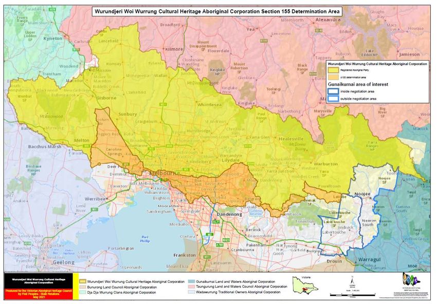
OFFICIALAttachment 1 – Map of Original Decision Area – Zone 1
(
Attachment 2 – Map of Proposal Area with GLaWAC and WTOAC areas of interest
excised
Negotiation Area Map
Proposed s155 variation boundary
negotiation area
Wadawurrung area of interest
limit of Wadawurrung area of interest
Gunaikurnai area of interest
inside negotiation area
outside negotiation area
16
OFFICIAL
S155 Determination
Bunurong Land Council Aboriginal Corporation
Gunaikurnai Land and Waters Aboriginal Corporation
Wadawurrung Traditional Owners Aboriginal Corporation
Wurundjeri Woi Wurrung Cultural Heritage Aboriginal Corporation
Victoria
±
VICGRID
GDA 94
Melbourne
Produced for the Victorian Aboriginal Heritage Council Taungurung Land and Waters Council Aboriginal Corporation Scale 1:375,000
This public ation may be of assistance to you but the State of Victoria and its employees
by First Peoples - State Relations 7.5 3.75 0 7.5 do not guarantee that the public ation is without f law of any kind or is wholly appropriate
for your particular purposes and therefore disclaims all liability for any error, loss or other
consequence whic h may arise from y ou relying on any information in this publication.
May 2021 kilometres K:\ GIS\ projects\Regis tered Aboriginal Parties\ VAHC Meeting May 2021\Negotiation Package\WTOAC Map-wv-27MAY21.mxdAttachment 3 – Map Extent of Council Determination of WWW Country
17
OFFICIALYou can also read