Central North Fire Management Area
Bushfire Risk Management Plan
2020
←
→
Page content transcription
If your browser does not render page correctly, please read the page content below
Central North Fire Management Area Bushfire Risk Management Plan 2020
Document Control
Document History
 Version                Date                    Author                      Section

 1.0                    13/12/2019              Steve Summers
 2.0                    5/06/2020               Steve Summers               2.3; 5.1

Agency Endorsements
 Agency                 Name & Title            Signature                    Date

Document Endorsement
Endorsed by Central North Fire Management Area Committee

Tony King
Chair, Central North FMAC
Date: 16 March 2020

Accepted by State Fire Management Council

Ian Sauer
Chair, SFMC
Date: 10 June 2020

Cover Page Photo Acknowledgement: Planned burn – Kelcey Tier, Leon Murray, TFS

                                                                                                Page 2 of 33
                                                            Central North Bushfire Risk Management Plan 2020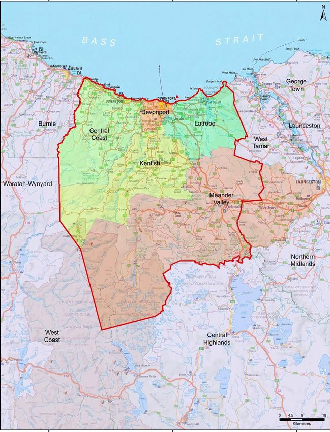
Contents
Glossary ....................................................................................................................................... 5
Acronyms ..................................................................................................................................... 7
Executive Summary ...................................................................................................................... 8
1.     Introduction ....................................................................................................................... 10
            Background .............................................................................................................................. 10
            Purpose of this Plan ................................................................................................................. 10
2.     Establishing the Context ...................................................................................................... 11
            Description of the Central North FMA..................................................................................... 11
            Fire Environment ..................................................................................................................... 12
            Climate and Bushfire Season ................................................................................................... 13
            Population and Community ..................................................................................................... 14
            Community Engagement ......................................................................................................... 16
3.     Identifying the Risks ............................................................................................................ 17
            Bushfire and Impact Scenarios ................................................................................................ 17
            State-wide Controls ................................................................................................................. 17
            Fire Management Area Controls ............................................................................................. 17
4.     Analysing and Evaluating Bushfire Risk ................................................................................ 18
            Analysing Bushfire Risks .......................................................................................................... 18
            Evaluating Bushfire Risks ......................................................................................................... 18
5.     Bushfire Risk Treatment ...................................................................................................... 19
            Treatment Plan ........................................................................................................................ 19
            Implementing Treatments ....................................................................................................... 19
            Strategic Fire Infrastructure .................................................................................................... 19
            Fuel Reduction Burning ........................................................................................................... 19
6.     Monitoring and Review ....................................................................................................... 21
            Review ..................................................................................................................................... 21
            Monitoring and Reporting ....................................................................................................... 21
References ................................................................................................................................. 22
Appendices ................................................................................................................................ 23
      Appendix 1: Treatment Plan .......................................................................................................... 23
      Appendix 2: Current Implementation Plans .................................................................................. 28
Maps ......................................................................................................................................... 29
      Map 1: Central North Fire Management Area Location ................................................................ 29
      Map 2: Tenure Summary Map for Central North Fire Management Area .................................... 31
      Map 3: Fuel Treatability for Central North Fire Management Area .............................................. 32
      Map 4: Vegetation for Central North Fire Management Area ...................................................... 33

                                                                                                                               Page 4 of 33
                                                                                           Central North Bushfire Risk Management Plan 2020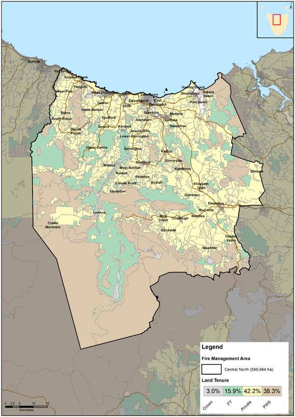
Glossary

Glossary
Asset                A term used to describe anything valued by the community that may be
                     adversely impacted by bushfire. This may include houses, infrastructure,
                     agriculture, production forests, industry, and environmental and heritage sites.
Asset Zone (AZ)      The geographic location of asset(s) and values of importance requiring bushfire
                     exclusion.
Asset Protection     An area adjacent to or near Asset Zones, the primary management purpose of
Zone (APZ)           which is to protect human life, property and highly valued assets and values.
                     Treatment can include intensive fuel reduction, manipulation of fuel moisture
                     or response plans.
Bushfire             Unplanned vegetation fire. A generic term which includes grass fires, forest
                     fires and scrub fires both with and without a suppression objective.
Bushfire Hazard      The potential or expected behaviour of a bushfire burning under a particular
                     set of conditions, i.e. the type, arrangement and quantity of fuel, the fuel
                     moisture content, wind speed, topography, relative humidity, temperature and
                     atmospheric stability.
Bushfire Risk        A systematic process to coordinate, direct and control activities relating to
Management           bushfire risk with the aim of limiting the adverse effects of bushfire on the
                     community.
Community Bushfire   A bushfire plan for community members that provides local, community-
Protection Plan      specific information to assist with bushfire preparation and survival. The focus
                     of the Bushfire Protection Plan is on bushfire safety options, and the intent of
                     the plan is to support the development of personal Bushfire Survival Plans.
Community Bushfire   An Emergency Management Plan for emergency managers and responders.
Response Plan        The Bushfire Response Plan aims to better protect communities and their
                     assets during bushfire emergencies, through the identification of protection
                     priorities and operational information.
Consequence          Impact(s) of an event on the five key areas: environment, economy, people,
                     social setting and public administration.
Control              A measure that modifies risk. This may be an existing process, policy, device,
                     practice or other action that acts to minimise negative risk or enhance positive
                     opportunities.
Fire Management      Classification system for the areas to be managed. The zoning system indicates
Zoning               the primary purposes for fire management for an area of land.
Fuel Break           A natural or manmade change in fuel characteristics which affects fire
                     behaviour so that fires burning into them can be more readily controlled.
Hazard               The area between a building and the bushfire-prone vegetation that provides
Management Area      access to a fire front for firefighting, which is maintained in a minimal fuel
                     condition and in which there are no other hazards present that will significantly
                     contribute to the spread of a bushfire.
Human Settlement     Term given for the dataset used to define where people live and work. The
Area                 dataset was developed for the purpose of risk modelling and was created using
                     a combination of building locations, cadastral information and ABS data.
                     Includes seasonally populated areas and industrial areas.
Land Management      An area that is managed to meet the objectives of the relevant land manager
Zone (LMZ)           such as: Traditional Owner practices, biodiversity conservation, production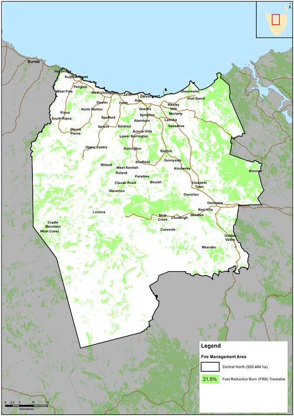
Glossary

                  forestry, farming or recreation. Management can include planned burning,
                  experimental treatments, fire exclusion or no planned action.
Likelihood        Chance of something happening. It is used as a general description of
                  probability and may be expressed qualitatively or quantitatively.
Risk Register     A document usually presented in a tabular form which lists concisely the
                  following information for each risk: the risk statement, source, hazard, impact
                  area, prevention/preparedness controls, recovery/response controls, level of
                  existing controls, likelihood level, risk level, confidence level and treatment
                  strategy.
Risk Treatment    Process of selection and implementation of controls to modify risk. The term
                  ‘risk treatment’ is sometimes used for the controls themselves.
Strategic Fire    An area located close to or some distance away from assets (e.g. the urban–
Management Zone   rural interface), the primary management purpose of which is to provide a
(SFMZ)            mosaic of areas of reduced fuel in strategic locations to reduce the speed and
                  intensity of bushfires, potential for spot-fire development, and size of
                  bushfires. Treatment is by fuel reduction burning and other bushfire protection
                  measures such as fire trails, water points, detection measures and response
                  plans.
Treatable         Types of vegetation which are suitable for fuel reduction burning, for example,
Vegetation        dry eucalypt forest, scrub, heathland and buttongrass.
Treatment Plan    A document related to the risk register presented in a tabular form which lists
                  concisely the following information for each risk: the agreed strategies to
                  manage the risk (i.e. treatments), the responsible organisations, proposed
                  completion date and comments.

                                                                                                     Page 6 of 33
                                                                 Central North Bushfire Risk Management Plan 2020
Acronyms
Acronyms
BRMP Bushfire Risk Management Plan
BRU Bushfire Risk Unit
DPIPWE Department of Primary Industries, Parks, Water and Environment
FFDI Forest Fire Danger Index
FMA Fire Management Area
FMAC Fire Management Area Committee
HSA Human Settlement Areas
LGA Local Government Area
PWS Parks and Wildlife Service
SFMC State Fire Management Council
STT Sustainable Timber Tasmania
TFS Tasmania Fire Service
Maps contained in this document may include data provided by DPIPWE (Land Tasmania), Parks and Wildlife
Service (Fire Management Section) and Tasmania Fire Service. These map products have been produced by
the Tasmania Fire Service. While all efforts have been taken to ensure their accuracy, there may be errors
and/or omissions in the data presented. Users of these products are advised to independently verify data for
accuracy and completeness before use.
Page 7 of 33
Central North Bushfire Risk Management Plan 2020Executive Summary
Executive Summary
This Bushfire Risk Management Plan (BRMP) identifies priorities for the treatment of bushfire risk in the
Central North Fire Management Area (FMA). It was developed by the Fire Management Area Committee
(FMAC) as required under sections 18 and 20 of the Fire Service Act 1979. This plan aims to coordinate and
influence the treatment of bushfire risk in the FMA.
The plan is strategic level and does not include all details of bushfire risk treatments, but does identify which
organisations or individuals are responsible for implementing them. The Central North FMAC will prepare a
written report at least yearly for the SFMC on the progress of implementation.
The treatment plan (Appendix 1) lists the actions determined by the FMAC required to treat bushfire risk in
the FMA.
The Central North FMA is located on the north coast of Tasmania. Encompassing an area of 540,464 ha, the
area contains a mix of fertile agricultural land, wineries, dispersed rural communities and large areas of
national park (including Mole Creek Karst caves and The Walls of Jerusalem National Park which is part of the
Tasmanian Wilderness World Heritage Area).
Approximately 82,000 persons reside within the FMA with several major population centres including
Devonport, Ulverstone, Penguin, Deloraine and Sheffield. The area has high transient populations associated
with the international recognised tourist destinations such as Cradle Mountain. Employment opportunities
though out the area is diverse with manufacturing, retail, agriculture, forestry, aquaculture, fishing, food and
beverages industry and tourism being the main employers.
Fire is an integral component of the Australian landscape and has the potential to impact all aspects and
values of the FMA. Historical records have indicated that fire ignitions have been predominately human
based though dry lighting events has ignited fires within the FMA. Changing climatic conditions are predicted
to lead to more extreme fire weather events increasing the fire risk to the communities and assets within the
FMA.
Understanding of the risk is essential to managing fire in the landscape. This interim document examines
and identifies areas that are of a high priority for the treatment of fire risk.
The FMAC together with computer simulation modelling have identified areas that are considered to be high
priority for treatment. These areas are:
• Don Reserve (west of Devonport);
• Cradle Valley (including Pencil Pine);
• Rubicon (Bakers Beach area);
• Heybridge;
• Lorinna (South of Mt Roland);
• Squeaking Point;
• Dooleys Hill (Latrobe).
Page 8 of 33
Central North Bushfire Risk Management Plan 2020Executive Summary
Treatment options to reduce risk within the FMA may include:
• Development of appropriate fire management zoning including assets protection zoning;
• Development and the implementation of fuel reduction programs adjacent to the communities at risk
including planned burning;
• Development of fire infrastructure including fuel breaks and access tracks adjacent to communities
under risk;
• Community consultation and engagement including community education initiatives.
Implementation of the treatment plan may be constrained by:
• Resource availability to implement appropriate management activities such as fuel break construction;
• Appropriate windows in the weather may not exist to carry out planned burns;
• Less than a quarter of the FMA is considered to be suitable for fuel reduction burning;
• the management of fire risk on private land is a considerable challenge for the Central North FMA
• Agreement with all stakeholders as to the proposed works.
Future iterations of this document will be based on an expanded risk profile based around likelihood and
consequences together with an understanding of the confidence in the data
Page 9 of 33
Central North Bushfire Risk Management Plan 2020Introduction
1. Introduction
Background
It is a requirement of Section 20 of the Fire Service Act 1979 that the FMAC prepare a fire protection plan for
its FMA. This BRMP fulfils that requirement. The BRMP is submitted to and approved by the SFMC.
The Fire Service Act 1979 requires that the fire protection plan is consistent with the State fire protection
plan and the State vegetation fire management policy.
Under the terms of reference for the Central North FMAC, the purposes of the committee are:
• Provide a forum for communication and collaboration between key stakeholders in the FMA;
• Enable a holistic and consistent approach, incorporating local knowledge, to identify strategic priorities
to reduce bushfire risk;
• Coordinate efforts and facilitate resource sharing to implement the strategic risk reduction priorities;
• Link the local community and the SFMC through ‘ground-truthing’ the bushfire risk assessment and
mitigation strategies;
• Through their advisory function, provide input into decisions and outcomes beyond the FMA.
Purpose of this Plan
The management of bushfire-related risk is a collective responsibility of the whole community, with
contributions made by numerous individuals, landowners and organisations.
An overriding aim of this BRMP is to document a coordinated approach to the identification and treatment
of bushfire risk in the Central North FMA Specific objectives include:
• Guide and coordinate bushfire risk management on all land within the FMA;
• Provide a reference point for the prioritisation and justification of bushfire treatment actions, as well
as supporting evidence for funding requests;
• Facilitate the integration of bushfire risk management into the business processes of councils,
organisations and land managers;
• Facilitate cooperation and the coordination of treatment actions between stakeholders;
• Clearly and concisely communicate bushfire risk to stakeholders and the community;
• Provide a basis for monitoring and reporting of implementation of bushfire risk treatments in the FMA.
This BRMP is a strategic-level document that does not provide detail on treatment actions. Individual
organisations and landowners, or collaborative groups, may have developed plans and processes for
implementation of bushfire risk treatment; these can be considered to be linked to the strategic priorities
identified here. This is an interim version of the BRMP – future versions will be based on a more
comprehensive risk assessment.
Page 10 of 33
Central North Bushfire Risk Management Plan 2020Establishing the Context
2. Establishing the Context
Description of the Central North FMA
The Central North FMA (Map1) is located the central north of Tasmania and covers an area of 550,464
ha. The FMA extends westwards along the north coast from Badger Head to Heybridge. The southern
part of the FMA extends westward from Golden Valley to the middle of Walls of Jerusalem National
Park, part of the Tasmanian wilderness world Heritage area (TWWHA).
The FMA encompasses the regional centres of Devonport and Ulverstone in the north and Sheffield
and Deloraine to the south.
The Central North FMA contains a mix of fertile agricultural land, wineries, dispersed rural communities
and large areas of national park (including Mole Creek Karst National Park and the Walls of Jerusalem
National Park which is part of the TWWHA)
The land tenure within the Central North FMA is approximately 58% of land is public land, the
remaining 42% is private/freehold land (Map2). The responsibility for public land management is
carried out by several agencies including TasNetworks, Hydro Tasmania, Telstra, TasWater, TasGas in
addition to the Department of Primary Industry, Parks, Water and the Environment and Sustainable
Timber Tasmania, the major land managers.
Land Manager/Agency % of Land Managed within the
FMA
Private Property 42.2 %
DPIPWE (including Parks and Wildlife Service and Crown Land 41.1%
Services)
Sustainable Timber Tasmania 15.9%
Hydro < 0.7%
Other (casements, commonwealth etc.) < 0.1%
Table 1: Overview of land tenure in FMAC
There are five local government areas wholly or partially included in the Central North FMA
including:
• Central Coast Council;
• Devonport City Council;
• Latrobe Council;
• Kentish Council;
• Meander Valley Council.Establishing the Context
Fire Environment
The fire environment is defined as the surrounding conditions, influences and modifying forces that
determine wildfire behaviour. This typically includes weather, topography, vegetation and ignition
history. Fire behaviour is influenced by a variety of factors including wind speed, relative humidity,
temperature, fuel moisture content, fuel arrangement and fuel load. These factors vary both
temporally and spatially across the FMA.
Topographically the FMA ranges from coastal lowlands in the north rising to alpine and sub alpine
environments in the south that are interspersed with major river systems including the Forth, Meander
and the Mersey rivers
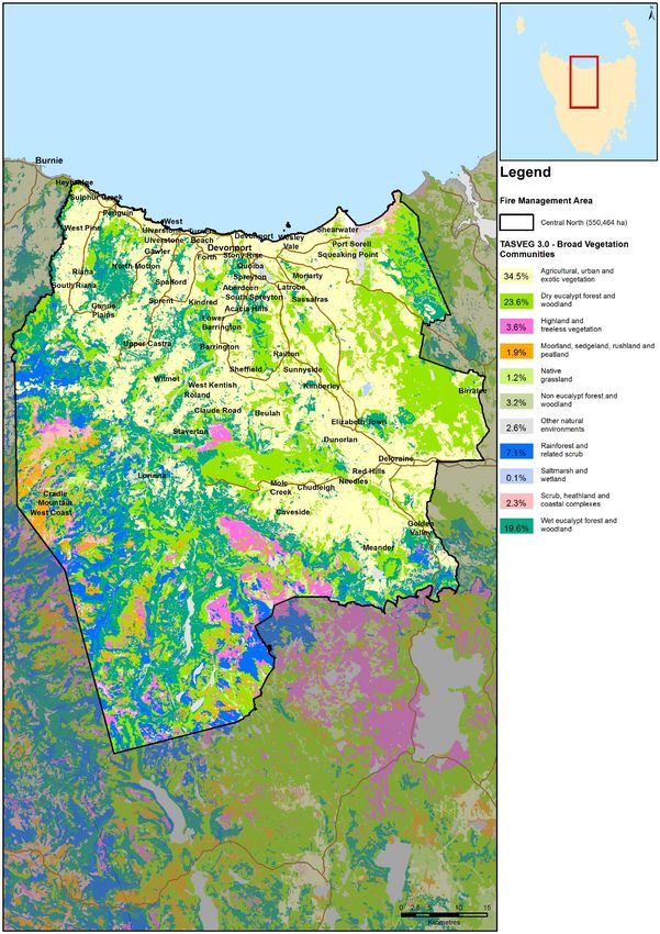
The vegetation in the Central North FMA is varied and can be categorised into groups that represent
landscape or broad vegetation classifications (Map 4). A description of each of the vegetation
classifications (Tas Veg 3) can be found in Harris and Kitchener, 2013 or at
www.dpipwe.tas.gov.au/tasveg.
The vegetation within a large portion of the Central North FMA has been highly modified for agriculture
resulting in the dominant vegetation type consisting of non-native agricultural, urban and exotic
vegetation (which includes plantations). The second most common vegetation type within the FMA
consists of highly flammable dry eucalypt forest and woodland.
Broad Vegetation Group (TasVeg 3, 2013) (ha) % in FMA Veg Flammability
Agricultural, Urban and Exotic Vegetation 190152 34.6 Medium
Dry Eucalypt Forest and Woodland 129957 23.7 Medium -High
Wet Eucalypt Forest and Woodland 107994 19.7 Medium
Rainforest and Related Scrub 39323 7.2 Low
Highland and Treeless Vegetation 19708 3.6 High
Non Eucalypt Forest and Woodland 17596 3.2 High
Other Natural Environments 14288 2.6 N/A
Scrub, Heathland and Coastal Complexes 12641 2.3 High – very high
Moorland, Sedgeland, Rushland and Peatland 10715 2.0 Low – very high
Native Grassland 6472 1.2 High
Saltmarsh and Wetland 649 0.1 Low
Total 549496 100
Table 2: Broad vegetation Groups Central North FMA
Vegetation can also be classified as treatable or untreatable which is an important consideration for
fuel reduction burning purposes. Agricultural lands while susceptible to fire, are not included in the
treatable vegetation group due to the land use priority allocated to this vegetation type. Treatable
vegetation present in the FMA is highlighted in Map 3 and detailed in Table 3:
Page 12 of 33
Central North Bushfire Risk Management Plan 2020Establishing the Context
Fuel Reduction Burning Treatability in Central North FMAC Area
(ha) (%)
Treatable 121005 22
Un-treatable 285240 51.8
Agricultural Land* (Untreatable by fire) 132687 24.1
Water 10325 1.9
Not Mapped 1206 0.2
100.0
* Classified in TASVEG3 as 'FAG' (agricultural landscapes where there are crops, pasture or orchards)
Table 3: Treatable vegetation- Central North FMA
Available records compiled by Tasmania Fire Service (TFS), Parks and Wildlife Service (PWS) and
Sustainable Timber Tasmania (STT) indicate that the vast majority (95%) of the FMA has been
untouched by fire in recent years. Only a very small percentage (1.7%) of the FMA is noted as having
been subject to fire at least once in recent years. Less than 0.5% of the FMA has been subject to more
than 2 or 3 fires at the same location.
In the last 5 years, 102 wildfires have been recorded within the FMA. Of these, the majority of fires
(45%) were considered to be deliberate ignitions, 7.8% were caused by escaped planned burns, 3.5%
were accidental, 3.9% were caused by lightning and in 18.6% of cases a cause was undetermined.
Analysis of these records indicate that deliberate ignitions (arson) is a problem within the FMA.
In 2016, major fires occurred in the Central Plateau with 26000 hectares being impacted. These fires
were as a result of lightning strikes compounded by drier conditions as a result of a drier and milder
preceding winter. This fire was a significant event with major impacts to the alpine environment
including organic soils such as peat.
There have been a number of major fires in the FMA in recent decades highlighted in Table 4.
Fire Name Year Area Burnt (ha)
Lake Mackenzie Complex (including Lake Bill) 2016 26109
Dunnings Rvt 1989 1943
Briggs Regional Reserve 2009 1794
Mt Roland (Gog Range) 1991 626
Table 4: Major Fire events in the Central North FMA
In the last 5 years, planned burns in the FMA conducted by PWS, STT & TFS have totalled 36.
Climate and Bushfire Season
The climate of the Central North FMA can be classified as temperate and is characterised by warm
summers and cold winters in the northern coastal parts of the FMA, together with mild summers and
cold winters in the southern parts of the FMA.
Average maximum daily temperatures within the FMA range from 21.5⁰ at Sheffield in February to
21.6⁰ in February at Devonport Airport. Devonport has an average minimum temperature of 4.1⁰ in
July with Sheffield having an average minimum of 2.5⁰ in July.
Page 13 of 33
Central North Bushfire Risk Management Plan 2020Establishing the Context
The FMA has a winter dominant seasonal rainfall pattern with wet winters and low summer rainfall.
Average monthly rainfall within the FMA ranges from a low of 36mm in January in Devonport to a high
of 158 mm average monthly rainfall in Sheffield in July.
Mean Annual rainfall Ranges from 778mm at Devonport Airport in the northern part of the FMA to
1179mm in Sheffield in the central part of the FMA.
Wettest months Winter. Devonport receives a July average of 95mm with Sheffield recording a July
average of 157mm of rain.
Driest Months Summer. Devonport receives a February average of 37mm of rain with Sheffield
recording a January mean rainfall of 52mm.
Windiest Months Summer
Months of least wind June
Cloudiest Month May. Devonport has a mean number of 14 cloudy days in May and Sheffield has a
mean number of 13 cloudy days in May
Table 5: Summary Climate Statistics – Central North FMA
Bushfires in Tasmania generally occur within the warmer and drier months of the year, typically from
November to March, though fires can occur outside this period if conditions conducive to fire exist.
The bushfire threat for the Central North FMA increases in late December with December/January
generally being the driest and hottest months when bushfires are more difficult to control.
Fire seasons and fuel reduction burning seasons can vary. Planned burning will be normally be carried
out during the spring or autumn seasons but is not restricted to these periods. Planned burning should
occur when the prescriptions that are applicable to the burn are met, not arbitrary dates.
Planned burning is limited by weather prescriptions, presence or otherwise of treatable fuels,
appropriate boundaries and the availability of human resources to successfully conduct the ignition
and suppression of the planned burn.
Climate is changing in Tasmania and it is evident from bushfire climate indicators (Fox-Hughes et al.
2015) that we can expect destructive bushfires to become more frequent. The Lake McKenzie (Central
Plateau) fire in 2016 was attributed to a major dry lightning event leading to severe consequences to
the natural environment.
Population and Community
The estimated residential population of the FMA as of 2016 is 82,000 people (ABS 2016).
The FMA encompasses the regional centres of Devonport and Ulverstone in the north, Sheffield and
Deloraine in the southern part of the FMA. Devonport and the immediate surrounding area, with a
population of 24,600 is the major centre within the FMA. Other significant population centres within
the FMA are Ulverstone (population 12,032), Penguin (population 3,849) and Deloraine (population
2,848). Latrobe and Devonport have been identified as areas that are experiencing significant growth.
Outside the major centres, the population is based around rural and agricultural activities. Within the
FMA, significant growth areas include the communities of Port Sorell, Hawley and Shearwater within
the Latrobe municipality.
The economy of the FMA is based around the key industries in the area including manufacturing, retail,
agriculture, aquaculture, forestry, fishing, food and beverages industry and Tourism.
Page 14 of 33
Central North Bushfire Risk Management Plan 2020Establishing the Context
Agricultural values are of particular significance to the Central North FMA. The coastal area from
Sassafras through to Penguin is one of Tasmania’s most productive farming areas. The Mersey/Forth
valley area (in the central north of the FMA, surrounding the banks of the Mersey River) produces 40%
of Tasmania's vegetable crop with large areas of land covered by fields of vegetables including onions,
potatoes, peas, carrots and beans and orchard fruits. Other important crops are poppies (grown for
the pharmaceutical industry) and pyrethrum (a botanical insecticide).
Tourism and recreation are important developing industries with the FMAC. Cradle Mountain Village
and accommodation facilities (including lodges, hotels, cottages, cabins and a caravan park) is an
international recognised tourism destination which generates a significant source of income for the
region and for Tasmania. Other national parks such as the walls of Jerusalem National Park and Mole
Creek Karst National Park are also important destinations for locals and tourists.
Tourist development areas are also experiencing growth. The tourist destinations experience a large
influx of transient visitors leading to local increases of populations during the normal periods of tourist
travel. Proposed developments over the next few years at Cradle Mountain will increase the transient
visitation which will have significant implications for emergency management.
Recreation activities are increasing within the FMA. Emergent industries such as mountain biking are
leading to an increase of transient visitor, often not familiar with the locations that they are recreating
in, this has implications for emergency management.
Within the FMA there exists critical infrastructure of importance to both the FMA as well as the state
including but not limited to:
• Communications Towers (Telstra) e.g. Kelcey Tier, Mt Claude and Dazzler Range, Dial Range;
• Hydro – Mersey Forth power scheme located on the Mersey and Forth rivers systems (7 power
stations);
• TasNetworks transmission lines:
o Sheffield to Burnie;
o Sheffield to Devonport;
o Sheffield to George Town;
o Sheffield to Palmerston;
o Sheffield to Fisher;
o Lemonthyme spur;
o Wesley vale spur;
o Ulverstone spur;
• Orica storage facilities at Heybridge and Dulverton;
• Timber Bridges;
• Origin Energy’s LPG Operation at Devonport;
• Alinta Gas pipeline into Tasmania at Westbury;
• Devonport Airport;
In addition to the values and infrastructure present within the FMA, assets of particular importance to
the community include:
• Community facilities present within the communities;
• Historic heritage including mountain huts in the Western Tiers and Central Plateau.
Page 15 of 33
Central North Bushfire Risk Management Plan 2020Establishing the Context
Community Engagement
The FMAC identifies the importance of ongoing community liaison and engagement with DPIPWE, STT,
associated specialists, specialist groups along with key stakeholders within the community, as being an
integral component of bush fire management.
Community engagement has and will continue to be centred on individual landowner engagement and
immediate neighbours as part of the planned burn development coordinated by the BRU, PWS and
STT.
Recent engagement activities coordinated by BRU engagement officers and TFS community
development officers have included:
• Bushfire Ready Information sessions - providing context around previous and upcoming
bushfire seasons,
• How TFS responds;
• Situational awareness (FDR and Alerts and Warnings);
• Community Protection Planning;
• Bushfire survival planning;
• Preparing individual landowner properties; and
• Introducing communities to the Disaster Reliance Education Tasmania resources in mid-
December 2019.
Communities that have been subject to engagement are:
• Meander Valley;
• Kimberley;
• Sheffield;
• Port Sorell;
• Deloraine;
• Squeaking Point;
• Railton;
• Westbury.
The Bushfire Ready Neighbourhood Program has been conducted at:
• Wegeena;
• Golden Valley;
• Jackey’s Marsh;
• Squeaking Point/Port Sorell.
Future consultation including Bushfire-Ready Neighbourhood Program is programmed for:
• Reedy Marsh Property Assessment Field Day - December 2019;
• Liffey – BRN round 3 (2018-2020) community Information Session - October 2018 BRN group
established - Setting up a phone tree;
• Meander Valley (Deloraine) – December 2019 – Bushfire-ready Info session;
• Loongana – October 2019 – Bushfire-ready Info.
Page 16 of 33
Central North Bushfire Risk Management Plan 2020Identifying the Risks
3. Identifying the Risks
Bushfire and Impact Scenarios
To set the scene for this plan, the bushfire scenarios under consideration are very large events, typically
10,000 to 20,000 hectares, occurring when fuel dryness and weather conditions combine to create one
or more days of very significant fire weather. Some important examples for the Central North FMA
include:
• A camp fire on a day of FFDI 44 escapes and ignites a bushfire that spreads and impacts the
community of Acacia hills resulting in destruction of numerous houses.
• A lightning strike on Mt Beecroft ignites a wildfire and rapidly spreads on a day of very high fire
danger (FDDI 48) impacting the community of Cradle Mountain leading to loss of structures,
tourist facilities and infrastructure and the trapping of transient visitors.
• A stolen car ignited on a day of very high fire danger (FDDI 40) spreads and impacts the industrial
hub of Westbury leading infrastructure loss and community impact.
State-wide Controls
The following controls are currently in place across Tasmania to help manage bushfire-related risk:
• Legislative controls – including Fire Service Act 1979 (e.g. Fire permit period, Total Fire Ban days,
campfires), National Parks and Reserves Management Act 2002 (e.g. fires and campfires),
abatement notices
• TFS public education (e.g. Bushfire-Ready Neighbourhoods, media campaigns)
• TFS planning – community protection planning (e.g. Community Response Plans)
• Inter-agency Fuel Reduction Program – funding and coordination of fuel reduction burning
• SFMC programs (e.g. Red-Hot Tips training program for fuel reduction burning on private land)
• FMAC – performance monitoring and reporting on this BRMP
• Tasmania Police and TFS – state-wide arson prevention programs
• Land subdivision and building standards (Bushfire-Prone Areas Code, Building Code of Australia)
• Suppression response preparedness – e.g. TFS local volunteer brigades, STT and PWS crews,
aircraft, pre-positioning of firefighting resources
• Weather forecasting (Bureau of Meteorology) and fire behaviour prediction (TFS, STT, PWS).
Fire Management Area Controls
Existing control measures for bushfire within FMA include but are not limited to:
• 36 TFS Brigades;
• PWS response crews - Cradle Mt Field Centre, Leven field centre, Narawantapu, Deloraine Field
centre and Mole Creek Field centre;
• STT crews;
• Disaster reliance education program;
• BRU, STT and PWS planned Burning programs.
• Bushfire-Ready Neighbourhoods (BRN) program;
Page 17 of 33
Central North Bushfire Risk Management Plan 2020Analysing and Evaluating Bushfire Risk
4. Analysing and Evaluating Bushfire Risk
Analysing Bushfire Risks
The analysis of bushfire risk for this plan considers the following:
• Consequences – what values and assets are at risk given the bushfire scenario under
consideration
• Existing controls – how effective the existing controls are at reducing the risk and how much
they are used
• Likelihood – how the likelihood of the consequence occurring is quantified, based on weather,
topography, fuels and ignition potential
• Confidence level – how certain we are about the evidence and data used
A state-wide assessment of consequences, likelihood and confidence is currently being undertaken by
the BRU with an updated risk register due be developed by June 2020.
Evaluating Bushfire Risks
In the absence of a dedicated risk register, assessment of the bushfire risk within the FMA was carried
out by the FMAC. A workshop was held in 2014 for FMAC members to discuss and analyse the results
of the preliminary risk assessment (BRAM). Agreed ‘at risk’ communities were then prioritised by
members of the Central North FMAC. This was reviewed in 2019 through discussion in the FMAC with
the results of this assessment displayed in table 6.
Human Settlement Area BRAM Risk FMAC priority Comments
rating rating
Don Reserve (west of Extreme High High fuel loads, planned burning
Devonport) program underway
Cradle Valley (including Pencil Extreme High High value assets, Tourism
Pine) infrastructure, transient
visitation, limited response
capability
Rubicon (Bakers Beach area) High High Isolated communities, Dead end
roads, High Fuel loads
Heybridge High - Extreme Med-high High fuel loads, planned burning
program underway
Lorinna (South of Mt Roland) High -Extreme Med Isolated Community
Squeaking Point High Med Dispersed community in heavy
fuels
Dooleys Hill (Latrobe) High Low High Fuel loads, potentially
untreatable fuels
Acacia Hills High High Dispersed community in heavy
fuels
Penguin High - Extreme Low Dial Range fuels, Construction in
bushfire prone areas
Table 6: Results of Strategic Assessment
Page 18 of 33
Central North Bushfire Risk Management Plan 2020Bushfire Risk Treatment
5. Bushfire Risk Treatment
Treatment Plan
The FMAC considered the costs, benefits, practicalities and environmental impacts of various control
options for the highest priority risks. The risk treatments that were determined from these
deliberations are recorded in the treatment plan (Appendix 1).
Individual landowners and organisations are usually responsible for implementing the treatments;
these are indicated in the treatment plan. One exception is fuel reduction burning that is planned and
conducted by the Inter-agency Fuel Reduction Program with the agreement of landowners.
Implementing Treatments
This BRMP does not guarantee a source of funding for treatment actions, nor does it provide a process
for seeking funding. The organisations and individuals that are responsible for delivering the bushfire
risk controls are responsible for developing further plans for implementation, as well as arranging
resources and funding.
The BRMP is, however, intended to provide evidence and justification for where funding and resources
are most appropriate to be committed by stakeholders to mitigate bushfire risk.
Many treatments identified in this plan will require environmental and cultural impact assessment.
These assessments are the responsibility of the individual organisations and are not covered by this
BRMP.
Resourcing constraint existing within the land management agencies precluding works on identified
treatments. Identified works have not been budgeted for within existing programs and while the FMAC
may have listed a program as a high priority, it may not be in organisations overall priority.
The FMAC consider that the management of fire risk on private land is a considerable challenge for the
Central North FMA.
Strategic Fire Infrastructure
The identification of strategic infrastructure including roads, fuel breaks and fire trails within the
Central North FMA has not yet been undertaken but has been identified as a priority by the FMAC in
future BRMPs.
Fuel Reduction Burning
Individual burn units are not identified in this BRMP but will need to be identified by further planning
from the organisations responsible for carrying out the fuel reduction burning.
There are many kinds of vegetation for which it is not appropriate or practical to conduct fuel reduction
burning (SFMC 2014). Vegetation Communities that can be treated are highlight in Map 3. The broad
vegetation communities within the FMA can be seen on Map 4.
The Fuel Reduction Program that is funded, coordinated and implemented by the TFS, PWS and STT is
undertaken on behalf of and with the agreement of individual landowners or organisations (e.g.Bushfire Risk Treatment
councils). The priorities of the Fuel Reduction Program are guided by the priorities identified in the
treatment plans across all FMAs.
Page 20 of 33
Central North Bushfire Risk Management Plan 2020Monitoring and Review
6. Monitoring and Review
Review
This BRMP, including appendices and maps, will be subject to a comprehensive review in 2020. The
revised BRMP will be based on a new risk assessment that may include revised input methods. The
review process will include examination of:
• Changes to the FMA, organisational responsibilities or legislation;
• Changes to the bushfire risk in the area;
• Major bushfire events;
• Shortcomings in data that can be improved;
• Change of usage of the area;
• New or changed asset values within the FMA.
Additional and changed data and values (both community and natural) identified by the review process
will be supplied to the BRU for inclusion in ongoing risk modelling being carried out at the state level.
Monitoring and Reporting
Progress towards completion of the treatments proposed will be monitored and reviewed at least
every 12 months by the FMAC; this will be documented in the Implementation Status Report which
should address as a minimum:
• Progress on implementation of treatments listed in the treatment plan;
• Planning outcomes including mitigation plans, community protection plans, community
response plans;
• Implementation progress of community programs;
• Completed fuel reduction burns
• Development and maintenance of Asset Protection Zones (APZ);
• Development and maintenance of strategic fire infrastructure.
At a state-wide level, the SFMC will examine the impacts of the strategic burning program on risk
management as part of the strategic fuel management program.
Page 21 of 33
Central North Bushfire Risk Management Plan 2020References
References
Fox-Hughes, P., Harris, R.M.B., Lee, G., Jabour, J., Grose, M.R., Remenyi, T.A. and Bindoff, N.L. (2015).
Climate Futures for Tasmania future fire danger: the summary and the technical report, Antarctic
Climate & Ecosystems Cooperative Research Centre, Hobart, Tasmania. Retrieved from
http://acecrc.org.au/wp-content/uploads/2015/12/Report_CFT_Future-Fire-Technical-
Report_2015_web.pdf.
Harris, S and Kitchener, A (2013). From Forest to Fjaeldmark: Descriptions of Tasmania's Vegetation.
(Edition 2) Department of Primary Industries, Parks, Water and Environment, Printing Authority of
Tasmania. Hobart.
SFMC (2014). Bushfire in Tasmania: A New Approach to Reducing Our Statewide Relative Risk.
Department of Police and Emergency Management, Hobart.
Page 22 of 33
Central North Bushfire Risk Management Plan 2020Appendices
Appendices
Appendix 1: Treatment Plan
Map Asset name and Priority Treatment Treatment Category Treatment Type and Responsible Completion date Comment
Location No detail organisation proposed
Cradle Mt. High 1 Fuel Reduction development of localised PWS TBA Cradle Valley is a major
(including Cradle mitigation strategy for tourist destination with a
Valley, Pencil Cradle Valley mixture of transient and
Pine) permanent residents.
Extensive tourist
infrastructure is present
within the valley and
surrounds
Cradle Mt. High 2 Fuel Reduction Continue Fuel reduction PWS 2020 Future planned burning
(including Cradle program: Quails hill; linked to mitigation strategy
Valley, Pencil Bonds Plains
Pine)
Cradle Mt. High 3 Community Safety Implement existing Kentish Council & Ongoing *Needs to Cradle Mt emergency Plan;
(including Cradle Cradle Mountain plans PWS be revisited (2020) Cradle Mt Emergency
Valley, Pencil (emergency, mitigation.) response plan - PWS;
Pine) Communication issues with
Tourists
Cradle Mt. High 4 Preparedness Review Bush fire TFS 2020 Note limited response
(including Cradle response plan 2013 capability by TFS. There has
Valley, Pencil been changes since 2013;
Pine) stakeholder interest in TFS
response plan being
reviewed and updated.
Cradle Mt. Med 5 Preparedness Public visitor information PWS 2021 Not currently programmed
(including Cradle - multiple languages with PWS
Valley, Pencil
Pine)
Claude road (Mt High 6 Fuel Reduction FRB program PWS, TFS Ongoing [revisit in
Roland) 2020]Appendices
Map Asset name and Priority Treatment Treatment Category Treatment Type and Responsible Completion date Comment
Location No detail organisation proposed
Claude road (Mt High 7 Behavioural Change Initiatives Review community TFS 2020 Talk with Hydro - Hydro
Roland) protection plan 2013 (Gowrie) - stores,
administration etc.
Claude road (Mt High 8 Preparedness Review bushfire response TFS 2020
Roland) plans 2013
Claude road (Mt High 9 Preparedness revisit co-operative TFS air operations 2020 Future major reconstruction
Roland) arrangements for the use of land used for airstrip by
of Vale airstrip TFS air operations
Claude road (Mt High 10 Behavioural Change Initiatives Investigate - BRN TFS 2020
Roland) community engagement
Devonport - Don High 11 Fuel Reduction Fuel reduction program TFS/ Devonport City Ongoing [revisit in
Reserve as per the don reserve Council 2020]
fire management plan
Devonport - Don High 12 Fuel Reduction Maintenance and Devonport City TBA
Reserve construction of fuel Council
breaks as per the don
reserve fire management
plan.
Devonport - High 13 Fuel Reduction Fuel Reduction burns as Council/ TFS Ongoing [revisit in
Kelcey Tier per Kelcey Tire FMP 2020]
Devonport - Med 14 Preparedness Emergency response Devonport City TBA
Kelcey Tier (evacuation) plans for Council & TFS
recreational activities -
i.e. Mountain Bikes
Devonport - Med 15 Preparedness Community engagement - TFS TBA
Kelcey Tier Public Awareness
Devonport - High 16 Fuel Reduction Maintenance and Devonport City TBA
Kelcey Tier construction of Fire break Council
between Kelcey Tier
Page 24 of 33
Central North Bushfire Risk Management Plan 2020Appendices
Map Asset name and Priority Treatment Treatment Category Treatment Type and Responsible Completion date Comment
Location No detail organisation proposed
Westbury _ High 17 Fuel Reduction fuel reduction program to PWS/ TFS Ongoing [to be
Reedy Marsh the north west of revisited 2020]
Westbury
Port Sorell & High 18 Behavioural change initiatives Develop Community TFS Revisit in 2020 Retirees, large blocks….
Squeaking Point Protection Plan
Port Sorell & high 19 Preparedness Development of Bushfire TFS 2020?
Squeaking Point Response Plan
Port Sorell - low 20 Fuel Reduction Implementation of fuel Latrobe Council/ Revisit in 2020
Pitcan Bushland reduction burn as per TFS/BRU
reserve BMP
Squeaking point High 21 Fuel Reduction Continuation of Fuel PWS
reduction program -
Squeaking Point Nature
Reserve
Marana Drive high 22 Fuel Reduction development of TFS 2020 High fuel loads, vulnerable
and Eagle Point mitigation strategy for isolated community
area - Bakers the area leading to future
Beach (east of planned burns Private and reserved land.
Rubicon Estuary)
FRB has its difficulties. Was
burn conducted north of
Marana Drive (Dec 2016)
Marana Drive High 23 Behavioural Change Initiatives Bush fire ready TFS
and Eagle Point neighbourhood.;
area - Bakers community engagement
Beach (east of
Rubicon Estuary)
Page 25 of 33
Central North Bushfire Risk Management Plan 2020Appendices
Map Asset name and Priority Treatment Treatment Category Treatment Type and Responsible Completion date Comment
Location No detail organisation proposed
Heybridge Med - 24 FR Investigate fuel reduction PWS & TFS To be revisited in PWS Burn April 2018.
high burning program 2020
Issues outside of the FMA.
West Coast FMA - Sea Eagle
Estate - Limitations for fuel
reduction burning, looking
at mechanical fuel breaks
(Investigating treatment
actions within this wider
area).
Heybridge High 25 Change Behaviour Investigate community TFS/BRU 2020
engagement - bushfire
ready neighbours
Jackeys Marsh high 26 Preparedness Development of local TFS/ PWS One-way road and heavy
mitigation strategy for fuels in and around the
the area community.
Mixed values within the
community makes
engagement difficult.
Jackeys Marsh High 27 Fuel Reduction Investigate FRB TFS/ PWS Revisit in 2020 Linked to development of
mitigation Strategy
Potential priority - warner
sugar loaf
Lorinna Medium 28 Fuel Reduction Investigate the protection Hydro and PWS
of Hydro assets.
Lorinna Medium 29 Fuel Reduction Planned Burning Program PWS 2020
- Cethana Cockatoo road;
Oliver’s road (north east
and east of Lorinna)
Lorinna Medium 30 Behaviour Change Initiatives Investigate - BRN TFS 2020 Lorinna has a CPP and CRP
community engagement November (2018).
Action item - check nearby
safer place for Lorinna
Page 26 of 33
Central North Bushfire Risk Management Plan 2020Appendices
Map Asset name and Priority Treatment Treatment Category Treatment Type and Responsible Completion date Comment
Location No detail organisation proposed
Latrobe (Dooleys High 31 Fuel Reduction Continue Fuel Reduction TFS Ongoing*Revisit in FRB - burn plan signed off.
Hill) burning program 2020 Intent to burn split between
autumn and spring due to
natural values.
Latrobe TBA 32 Preparedness Community mitigation TFS Revisit in 2020
strategy
Latrobe Medium 33 Fuel Reduction Investigate Fuel TFS Ongoing*Revisit in
Reduction burning 2020
program
Latrobe medium - 34 Preparedness Develop response Latrobe Council & PWS input
(Warrawee) high (evacuation) plan - PWS
Mountain Bike
Penguin Medium 35 Fuel Reduction Investigate FRB in the dial PWS and TFS Revisit in 2020 Some untreatable
range vegetation.
Acacia Hills (also Low 36 Preparedness/Behaviour Investigate engagement TFS 2020 2.5-5.0-acre properties;
Lower Change options - BRN human settlement area;
Barrington, approx. 80 properties;
Lower Kentish) Community education Previous engagement by
about the risks (access, local brigade has success;
water supply, power) Only has tank water;
Prone to power outages;
Between Railton Med 37 Preparedness Response (Evac) planning Council/ TFS 2021
& Sheffield - Mountain Bikes
(Badgers Ranges)
Railton - Sykes Low 38 Fuel Reduction complete planned Burn TFS Revisit in 2020 Partial completion (65%).
Sanctuary as per the Sykes
Sanctuary BMP
Dulverton Low 39 preparedness/Ignition Development of TFS/ Dulverton waste Revisit in 2020 Revisit with stakeholders
Management emergency management management facility
plan
Ulverstone Low 40 Fuel Reduction complete planned burns TFS 2020 Planned Burns: Ulverstone
Golf Club; Knights road;
Manning jetty road
Page 27 of 33
Central North Bushfire Risk Management Plan 2020Appendices
Appendix 2: Current Implementation Plans
Plan Owner Plan Title Year Treatment numbers
TFS Bushfire response plan Claude Road 2013
TFS Community protection plan Claude Road 2103
TFS Bushfire response plan Cradle valley 2013
TFS Community protection plan Cradle Mt 2013
TFS Bushfire response plan Lorinna 2018
TFS Community protection plan Lorinna 2018
TFS Bushfire response plan Jackeys marsh 2014
TFS Community protection plan Jackeys marsh 2014
TFS Bushfire response plan Meander 2014
TFS Community protection plan Meander 2014
TFS Bushfire response plan Golden valley 2016
TFS Community protection plan Golden valley 2016
Devonport Council Kelcey Tier Fire management plan 2017 13, 14, 15
Devonport Council Don Reserve fire management plan 2017 11,12
Latrobe Council Sykes Sanctuary FMP 2019 38
Latrobe Council Dooleys Hill MP ?? 2019 33
STT Northern Region Fire Action Plan 2019-2020 2019
PWS PWS Fire Action Plan 2019 2020 2019
PWS Cradle Valley fire prevention plan 2008 1, 3,
PWS Cradle Mt Emergency Response plan 2019 2019 3,5
PWS PWS Tasmania Northern Region Strategic Fire 2009
Management Plan
PWS Northern West Region Strategic Fire 2012
Management Plan (2012).
Councils(collective) Mersey Leven Emergency Management plan v3 2017Maps Maps Map 1: Central North Fire Management Area Location
Maps

Local government areas – Central North FMAC

                                                                                 Page 30 of 33
                                              Central North Bushfire Risk Management Plan 2020
Maps
Map 2: Tenure Summary Map for Central North Fire Management Area
Page 31 of 33
Central North Bushfire Risk Management Plan 2020Maps
Map 3: Fuel Treatability for Central North Fire Management Area
Page 32 of 33
Central North Bushfire Risk Management Plan 2020Maps
Map 4: Vegetation for Central North Fire Management Area
Page 33 of 33
Central North Bushfire Risk Management Plan 2020You can also read