Urban Tree Canopy Assessment Woodland, California 2018 - City of Woodland
←
→
Page content transcription
If your browser does not render page correctly, please read the page content below
Urban Tree Canopy Assessment Woodland, California 2018
Urban Tree Canopy Assessment
Woodland, California
 2018

                                                                                Prepared For:
                                                                       City of Woodland
                                                                          300 First Street
                                                                  Woodland, CA 95695
                                                                  Phone: 530-661-2000
                                                                 www.cityofwoodland.org

                                                                                Prepared By:
                                                              Davey Resource Group, Inc.
                                                            6005 Capistrano Ave. Suite A
                                                            Atascadero, California 93422
                                                                   Phone: 805-461-7500
                                                                Toll Free: 800-966-2021
                                                                      Fax: 805-461-8501
                                                                      www.davey.com/drg

                                Acknowledgements:
        This project was made possible in part by grant funding from CalFire.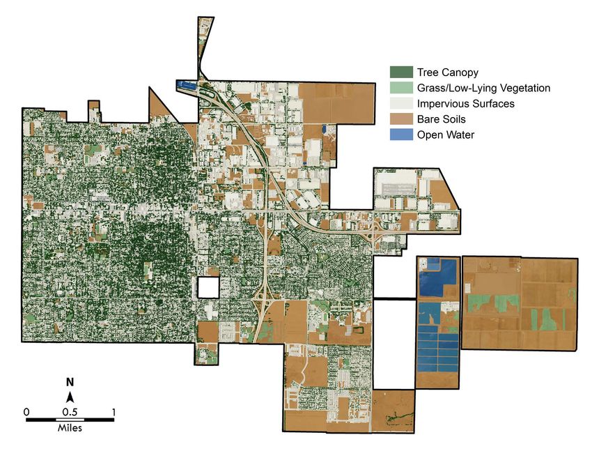
Table of Contents
Executive Summary........................................................................................................................................... 1
   Land Cover .................................................................................................................................................... 1
   Environmental Benefits ................................................................................................................................. 2
   Management Applications .......................................................................................................................... 3
Introduction......................................................................................................................................................... 5
   Urban Tree Canopy and Geographic Information Systems ................................................................. 5
Benefits of Urban Tree Canopy ..................................................................................................................... 7
   Air Quality ..................................................................................................................................................... 7
   Carbon Reduction ......................................................................................................................................... 8
   Stormwater Reduction .................................................................................................................................. 8
   Energy Savings.............................................................................................................................................. 9
   Aesthetics and Socioeconomics ................................................................................................................. 10
   Calculating Tree Benefits .......................................................................................................................... 10
Land Cover ...................................................................................................................................................... 11
   Overall Canopy .......................................................................................................................................... 11
   Tree Canopy Health................................................................................................................................... 13
   Tree Canopy by Council District .............................................................................................................. 15
   Tree Canopy by Zoning ............................................................................................................................ 17
   Tree Canopy by Tree Maintenance Zone .............................................................................................. 19
   Canopy Cover by Parks ............................................................................................................................ 21
   Land Cover by Landscape and Lighting Districts.................................................................................. 23
   Canopy Cover Comparison with Neighboring Communities............................................................... 24
   Historic Change ........................................................................................................................................... 25
   Preferred Planting Sites ............................................................................................................................ 27
Conclusion ......................................................................................................................................................... 29
Appendix A: References................................................................................................................................ 31
Appendix B: Methodology............................................................................................................................ 32
   Calculating Benefits.................................................................................................................................... 32
     Air Quality ............................................................................................................................................... 32
     Carbon Storage and Sequestration.................................................................................................... 32
     Stormwater .............................................................................................................................................. 32
     Priority Planting Analysis ...................................................................................................................... 33
   Land Cover Extraction and Accuracy Assessment ................................................................................. 33
     Classification Workflow ........................................................................................................................ 34
     Automated Feature Extraction Files .................................................................................................... 34
   Accuracy Assessment Protocol .................................................................................................................. 35
   Land Cover Accuracy ................................................................................................................................. 35
Appendix C: Tables and Figures ................................................................................................................. 38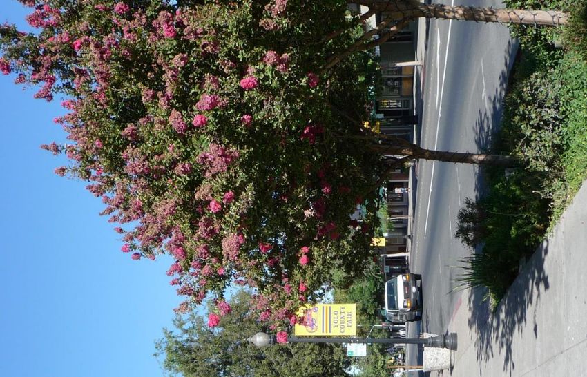
Figures
 Figure 1: Woodland Land Cover Classes ............................................................................................. 2
 Figure 2: Annual Benefits Summary for Woodland ............................................................................ 2
 Figure 3: Land Cover Mapping............................................................................................................... 6
 Figure 4: Air Pollutant Benefits Summary .............................................................................................. 7
 Figure 5: Stormwater Runoff Diagram .................................................................................................. 9
 Figure 6: Woodland Land Cover Classification Summary ............................................................... 11
 Figure 7: Summary of Canopy Health ................................................................................................. 13
 Figure 8: Neighboring Municipalities Canopy Coverage Comparison.......................................... 24
 Figure 9: Woodland’s Top 10 Largest Parks - Historic Tree Canopy Change from 2009 ....... 25
 Figure 10: Tree Maintenance Zone Acreage - Historic Tree Canopy Change from 2009 ....... 26
 Figure 11: Canopy Coverage by Zoning Category ......................................................................... 41

Tables
 Table 1: Annual Environmental Benefits Summary............................................................................... 3
 Table 2: Woodland Land Cover Classification Summary ................................................................ 11
 Table 3: Summary of Canopy Health .................................................................................................. 13
 Table 4: Council District Summary by Acreage ................................................................................. 15
 Table 5: Tree Canopy by Zoning ......................................................................................................... 17
 Table 6: Tree Canopy by Maintenance Zone .................................................................................... 19
 Table 7: Canopy Cover in Woodland’s Top Ten Largest Parks ..................................................... 21
 Table 8: Canopy Cover by Landscape and Lighting Districts ......................................................... 23
 Table 9: Historic Canopy Cover ........................................................................................................... 25
 Table 10: Stormwater Factors Used to Prioritize Tree Planting Sites ............................................ 27
 Table 11: Priority Planting by Land Use ............................................................................................. 27
 Table 12: Classification Matrix ............................................................................................................. 35
 Table 13: Confidence Interval............................................................................................................... 37
 Table 14: Canopy Cover in Woodland Parks ................................................................................... 38
 Table 15: Historic Canopy Cover for Woodland Parks................................................................... 39
 Table 16: Historic Canopy Cover for Woodland Tree Maintenance Zones ................................ 40

Maps
 Map 1: Woodland by Land Cover Class ............................................................................................ 12
 Map 2: Tree Canopy Health ................................................................................................................. 14
 Map 3: Tree Canopy by Council District ............................................................................................. 16
 Map 4: Woodland Zoning ..................................................................................................................... 18
 Map 5: Tree Canopy by Maintenance Zone ...................................................................................... 20
 Map 6: Woodland Parks ....................................................................................................................... 22
 Map 7: Planting Priority ......................................................................................................................... 28
Executive Summary
   The amount and distribution of leaf surface area is the driving force behind the urban forest’s
   ability to produce benefits for the community (Clark et al, 1997). As canopy cover increases, so
   do the benefits contributed by leaf area. These benefits, which include energy savings, air
   quality, water quality, stormwater interception, aesthetic and other socioeconomic benefits can
   be quantified for their value to the community. Understanding the location and extent of tree
   canopy is key to developing and implementing sound management strategies that promote the
   sustainability and growth of Woodland’s urban forest resource and the benefits it provides.
   In 2010, the City of Woodland contracted with Davey Resource Group (DRG) to conduct an
   urban tree canopy (UTC) assessment 1 using high-resolution aerial imagery and remote sensing
   software. The assessment resulted in a GIS map which detailed the location and extent of tree
   canopy (public and private) across the community. Since then, the urban forest has experienced
   changes in tree cover. In 2017, the City of Woodland contracted with DRG to develop an Urban
   Forest Master Plan (UFMP). An updated UTC assessment was developed as part of the plan
   development process. This report provides an update on tree canopy along with mapping other
   primary land cover, including impervious surface, grass and low-lying vegetation, bare soil, and
   water. This assessment also explores the condition of tree canopy and the benefits from this
   urban forest resource. As of 2018, the current land cover in Woodland is comprised of:
         •   14.5% Tree Canopy
         •   46.8% Impervious Surfaces
         •   36.1% Pervious Surfaces (bare soils and low-lying vegetation)
         •   2.6% Open Water

   Land Cover
   The City of Woodland encompasses approximately 15 square miles (9,624 acres). Excluding
   impervious surface (4,500 acres) and open water (260 acres), Woodland contains
   approximately five square miles (3,470 acres) which has the potential to support tree canopy.
   The following characterizes land cover in Woodland:
         •   1,394 acres (14.5%) of tree canopy, including trees and woody shrubs.
         •   4,500 acres (46.8%) of impervious surface, including roads and structures.
         •   35.2 acres of tree canopy in parks, an average of 30.1% canopy cover.
         •   73.2% of the urban forest canopy is in fair or better condition.
         •   148,194 tons of carbon (CO₂) is stored in the woody and foliar biomass of
             Woodland’s urban forest (public and private), valued at $5.2 million.
         •   A maximum canopy potential of 50.5% for the total urban forest (public and private).
         •   Since 2009, overall tree canopy has increased by 727 acres (109%) and the
             percentage of tree canopy cover has increased from 6.9% to 14.5%.
         •   Since 2009, tree canopy in parks has increased by 15 acres (74.4%) and the
             percentage of tree canopy cover in parks increased from 16.8% to 30.1%.

   1   City of Woodland, California Urban Forest Resource Analysis and Community Canopy Study, February 2010

1 Executive Summary                                                                                     2018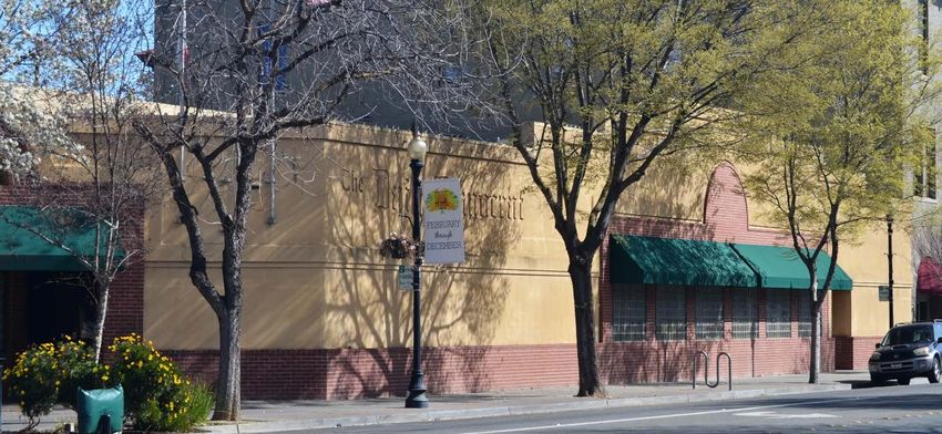
Tree Canopy
                        Bare Soil                                 14.49%
                         28.74%

                                                                         Grass/Low
                                                                         Vegetation
                                                                           7.31%

                                                                        Open Water
                      Impervious                                          2.70%
                        Surface
                        46.76%

                              Figure 1: Woodland Land Cover Classes

  Environmental Benefits
  To determine the environmental benefits from the urban forest (public and private trees),
  Woodland’s land cover was analyzed with i-Tree Canopy (v6.1). The analysis estimates that
  Woodland’s trees annually provide $568,075 in benefits to air quality and stormwater runoff
  reduction (Figure 2, Table 2), including:
       •   Removing 40 tons of air pollutants, including carbon monoxide (CO), nitrogen dioxide
           (NO₂), ozone (O₃), sulfur dioxide (SO₂), and particulate matter (PM₁₀), valued at
           $181,749.
       •   Reducing stormwater runoff by 15.3 million gallons annually, valued at $122,038.
       •   Removing (sequestering) an additional 7,496 tons of CO₂, valued at $264,288.

                      Stormwater                                        O₃
                         Runoff                                       19.58%
                        21.48%

                                                                           PM₁₀
                                                                          11.88%

                        CO₂                                            CO, NO₂, and
                    Sequestered                                            SO₂
                      46.52%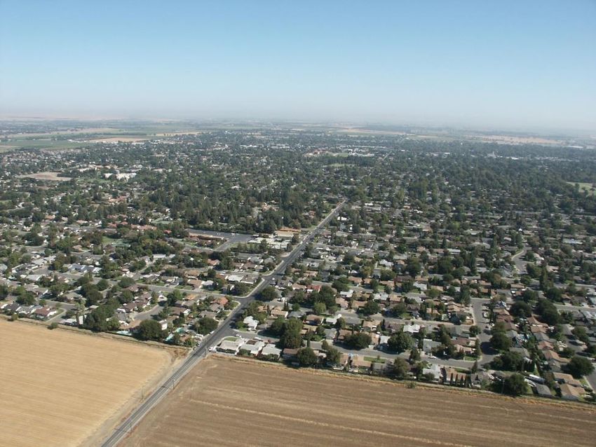
Table 1: Annual Environmental Benefits Summary
                          Item              Value ($) % of Total Benefits
                          CO₂ Sequestered    264,288         46.52
                          Stormwater Runoff 122,038          21.48
                          O₃                 111,232         19.58
                          PM₁₀                67,496         11.88
                          CO, NO₂, and SO₂     3,021          0.53
                          Total             $568,075         100%

   Management Applications
   Understanding the location and extent of tree canopy is key to developing and implementing
   sound management strategies that promote the sustainability of Woodland’s urban forest
   resource. The data, combined with existing and emerging research, enables managers to
   balance urban growth with tree preservation and aids in identifying and assessing urban
   forestry opportunities. A spatial understanding of tree canopy can help urban forest managers
   and city leadership align urban forestry objectives with community vision. Identifying priority
   planting areas that yield the most return on investment is especially important.
   Woodland has an existing tree canopy cover of 14.5% and a maximum potential for 50.5%
   canopy. To help identify the most beneficial sites for expanding canopy, potential sites were
   mapped and then prioritized based on soils, slope, and existing canopy. These maps are
   valuable tools for guiding tree planting projects. Recommendations for maintaining existing
   canopy and promoting growth include:
       • Use priority planting site analyses to identify new tree planting locations to reduce
          erosion and soil degradation and decrease canopy fragmentation.
       • Use the canopy health map to identify and explore locations where environmental
          factors like soil and/or water conditions may be impacting tree or species health.
       • Promote species diversity for greater resilience and pest resistance.
       • Plant large-stature shade trees where space and design allow.
       • Remove and replace failing and over-mature trees.
       • Incentivize tree planting on private property, particularly in high and very high
          priority planting areas.

3 Executive Summary                                                                         2018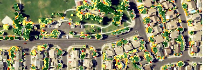
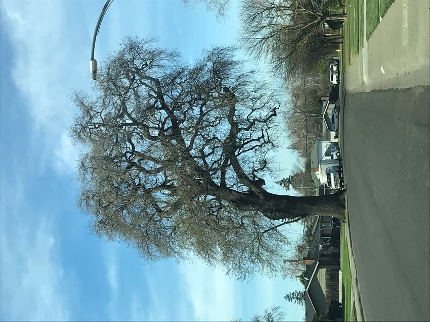
California is famous for its oaks. Here, the City has constructed sidewalk around the trunk of a
                                                 large oak tree.

2018                                                                              Executive Summary 4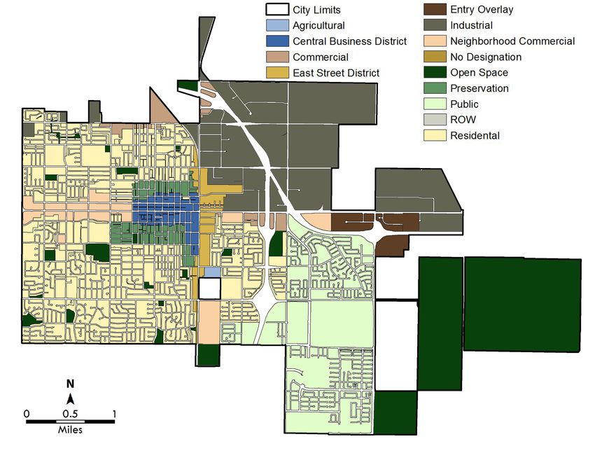
Introduction
   Woodland celebrated its first Arbor Day In 1903. Trees play a significant role in the community
   and the City is dedicated to developing tree canopy and protecting the health of this resource.
   By 1920, Woodland had been unofficially declared “the City of Trees” and the city flag was
   embellished with a valley oak. Numerous ordinances and programs have been created over
   the years to encourage the expansion of the community forest.
   Individual trees play an essential role in the community of Woodland by providing many
   benefits, tangible and intangible, to residents, visitors, and neighboring communities. Research
   demonstrates that healthy urban trees can improve the local environment and lessen the impact
   resulting from urbanization and industry (Center for Urban Forest Research, 2017). Trees
   improve air quality, reduce energy consumption, help manage stormwater, reduce erosion,
   provide critical habitat for wildlife, and promote a connection with nature.
   Woodland is located in the Central Valley of California and has a population of 59,068
   according to 2016 estimates by the United States Census Bureau. The community experiences
   an average summer temperature of 95°F, an average winter temperature of 39°F and average
   annual precipitation of 21.4 inches.

   Urban Tree Canopy and Geographic Information Systems
   Urban Tree Canopy is the layer of leaves, branches, and stems that cover the ground when
   viewed from above. Since trees provide benefits to the community that extend beyond property
   lines, the assessment includes all tree canopy within the borders of the community and does not
   distinguish between publicly-owned and privately-owned trees. To place tree canopy in context
   and better understand its relationship within the community, the assessment included other
   primary landcover classifications, including impervious surfaces, pervious surfaces, bare soils,
   and water.
   As more communities focus attention on environmental sustainability, community forest
   management has become increasingly dependent on geographic information systems (GIS). GIS
   is a powerful tool for urban tree canopy mapping and analysis. Understanding the extent and
   location of the existing canopy is key to identifying various types of community forest
   management opportunities, including:
       • Future planting plans
       • Stormwater management
       • Water resource and quality management
       • Impact and management of invasive species
       • Preservation of environmental benefits
       • Outreach and education
   High-resolution aerial imagery (2016) and infrared technology remotely mapped tree canopy
   and land cover (Figure 3). The results of the study provide a clear picture of the extent and
   distribution of tree canopy within Woodland. The data developed during the assessment
   becomes an important part of the City's GIS database and provides a foundation for
   developing community goals and urban forest policies. The primary purpose of the assessment
   was to update benchmark values and assess change since 2009. The results will enable
   managers to understand recent changes in the urban forest and measure the success of long-
   term management objectives over time. With this data, managers can determine:

5 Introduction                                                                               2018
• Woodland’s progress towards local and regional canopy goals.
• Changes in tree canopy over time and in relation to growth and development.
• The location and extent of canopy at virtually any level, including land use, zoning,
parks.
• The location of available planting space to develop strategies for increased canopy in
underserved areas.
In addition to quantifying existing urban tree canopy, this assessment illustrates the potential
for increasing tree canopy across Woodland. The data, combined with existing and emerging
urban forestry research and applications, can provide additional guidance for determining a
balance between growth and preservation and aid in identifying and assessing urban forestry
opportunities.
Figure 3: Land Cover Mapping
High-resolution aerial imagery (left) is used to remotely identify existing land cover. Infrared
technology delineates living vegetation including tree canopy (middle). Remote sensing software
identifies and maps tree canopy and other land cover (right).
2018 Introduction 6Benefits of Urban Tree Canopy
Urban forests continuously mitigate the effects of urbanization and development and protect
and enhance the quality of life within the community. The amount and distribution of leaf surface
area is the driving force behind the ability of the urban forest to produce benefits for the
community (Clark et al, 1997). Healthy trees are vigorous, often producing more leaf surface
area each year. Trees and urban forests provide quantifiable benefits to the community in the
following ways:
Air Quality
Urban trees improve air quality in five fundamental ways:
• Reducing particulate matter (dust)
• Absorbing gaseous pollutants
• Providing shade and transpiration
• Reducing power plant emissions
• Increasing oxygen levels
Urban trees protect and improve air quality by intercepting particulate matter (PM₁₀), including
dust, ash, pollen, and smoke. The particulates are filtered and held in the tree canopy. Trees
and forests also absorb harmful gaseous pollutants like ozone (O₃), nitrogen dioxide (NO₂),
and sulfur dioxide (SO₂). Shade and transpiration reduce the formation of O₃, which is created
during higher temperatures. In fact, scientists are now finding that some trees may absorb more
volatile organic compounds (VOC’s) than previously thought (Karl et al, 2010). VOC’s are a
class of carbon-based particles emitted from automobile exhaust, lawnmowers, and other
human activities. By reducing energy needs, trees also reduce emissions from the generation of
power. Also, through photosynthesis, trees and forests increase oxygen levels.
Annually, in Woodland, trees remove 80,208 pounds of air pollutants for a total value of
$181,749, including: carbon monoxide (CO), nitrogen dioxide (NO2), ozone (O3), sulfur dioxide
(SO2), and particulate matter (PM10).
O₃
$111,232
61.20%
SO₂
$22Carbon Reduction
Trees and forests directly reduce CO₂ in the atmosphere through growth and sequestration of
carbon as woody and foliar biomass. When trees die and decay, they release much of the
stored carbon back to the atmosphere. In urban environments, most trees that die are removed
and chipped or disposed of as firewood, releasing stored carbon. Thus, carbon storage is an
indication of the amount of carbon that can be gained and lost over the course of a trees
lifecycle through growth and decomposition. Indirectly, trees and forests reduce CO₂ by
lowering the demand for energy and reducing the CO₂ emissions from the consumption of
natural gas and the generation of electric power.
Purchasing emission allowances (offsets) has led to the acceptance of carbon credits as a
commodity that can be exchanged for financial gain. Thus, some communities are exploring the
concept of planting trees to develop a carbon offset (or credit). UESPD and USDA Forest Service
recently led the development of Urban Forest Greenhouse Gas Reporting Protocol (McPherson
et al, 2008/2010). The protocol establishes methods for calculating reductions and provides
guidance for accounting and reporting. These methods guide urban forest managers in
developing tree planting and stewardship projects that could be registered for greenhouse gas
reduction credits.
The urban forest in Woodland currently stores 148,194 tons of carbon (CO₂) in woody biomass,
valued at over $5.2 million. Furthermore, annually, Woodland trees sequester 7,496 tons of
carbon valued at $264,288.
Stormwater Reduction
Trees and forests improve and protect the quality of surface waters, such as creeks, rivers, and
lakes, by reducing the impacts of stormwater runoff through:
• Interception
• Increasing soil capacity and rate of infiltration
• Reducing soil erosion
Trees intercept precipitation in their canopy, which acts as a mini-reservoir (Xiao et al, 1998).
During storm events, this interception reduces and slows runoff. In addition to catching
stormwater, canopy interception lessens the erosive impact of raindrops on bare soil. Root
growth and root decomposition increase the capacity and rate of soil infiltration by rainfall and
snowmelt (McPherson et al, 2002). Each of these processes greatly reduces the flow and volume
of stormwater runoff, avoiding erosion and preventing sediments and other pollutants from
entering local creeks and waterways.
Surface runoff is a cause for concern in many urban areas as it contributes to the pollution and
flooding of streams, wetlands, rivers, lakes, and oceans. Figure 4 illustrates the benefits of trees
to reducing stormwater runoff. When rain falls on impervious surfaces it cannot permeate into
the soil. Instead, it collects into flows and runoff. The runoff picks up sediment, trash, oil, bacteria,
and other contaminants from paved surfaces and carries this non-point source pollution to bodies
of water. Along with pollutants, stormwater runoff can produce flows with large volumes of
water in a short period of time, causing flooding and erosion.
During precipitation events, some portion of the precipitation is intercepted by vegetation (trees,
shrubs, grass, other vegetation). Some of the water is temporarily held by leaves and bark and
later evaporates or gradually infiltrates the soil, which slows the movement of water off site.
The portion of the precipitation that reaches the ground and does not infiltrate into the soil or
falls on impervious surfaces, becomes surface runoff (Hirabayashi, 2012). In urban areas, the
2018 Benefits of Urban Tree Canopy 8substantial extent of impervious surface increases the amount of surface runoff and the cost of
infrastructure a community must invest to manage stormwater for the safety of residents and
property.
Annually, the urban forest in Woodland reduces stormwater runoff by 15.3 million gallons
valued at $122,038. This accounts for 21.5% of the annual environmental benefits provided
by Woodland’s urban forest. A full explanation of stormwater value calculations are found in
Appendix B.
Figure 5: Stormwater Runoff Diagram
Energy Savings
Urban trees and forests modify climate and conserve energy in three principal ways:
• Shading dwellings and hardscape
• Transpiration
• Wind reduction
Shade from trees reduces the amount of radiant energy absorbed and stored by hardscapes
and other impervious surfaces, thereby reducing the heat island effect, a term that describes
the increase in urban temperatures in relation to surrounding locations. Transpiration releases
9 Benefits of Urban Tree Canopy 2018water vapor from tree canopies, which cools the surrounding area. Through shade and
transpiration, trees and other vegetation within an urban setting modify the environment and
reduce heat island effects. Temperature differences of more than 9°F (5°C) have been observed
between city centers without adequate canopy cover and more vegetated suburban areas
(Akbari et al, 1997).
Trees reduce wind speeds relative to their canopy size and height by up to 50%. Trees also
influence the movement of warm air and pollutants along streets and out of urban canyons. By
reducing air movement into buildings and against conductive surfaces (e.g., glass and metal
siding), trees reduce conductive heat loss from buildings, translating into potential annual
heating savings of 25% (Heisler, 1986). Reducing energy needs has the bonus of reducing
carbon dioxide (CO₂) emissions from fossil fuel power plants.
Aesthetics and Socioeconomics
While perhaps the most difficult to quantify, the aesthetic and socioeconomic benefits from trees
may be among their greatest contributions, including:
• Beautification, comfort, and aesthetics
• Shade and privacy
• Wildlife habitat and ecosystem health
• Opportunities for recreation
• Creation of a sense of place and history
• Human health
Many of these benefits are captured as a percentage of property values, through higher sales
prices where individual trees and forests are located.
Calculating Tree Benefits
While all these tree benefits are provided by the urban
forest, it can be useful to understand the contribution of just
one tree. Individuals can calculate the benefits of individual
trees to their property by using the National Tree Benefit
Calculator or with i-Tree Design. (design.itreetools.org).
Calculate My Tree
Benefits
2018 Benefits of Urban Tree Canopy 10Land Cover
Overall Canopy
Woodland encompasses an area of approximately 15 square miles (9,624 acres), of which
approximately two (2) square miles (1,394 acres) are tree canopy (Figure 5). In addition to
tree canopy, Woodland’s land cover includes 46.8% impervious surface, 28.7% bare soil, 7.3%
grass and low-lying vegetation, and 2.7% open water.
Considering the existing tree canopy and possible tree canopy over impervious areas, the
canopy potential of Woodland is 50.5%%, although the actual potential may be higher where
tree canopy can shade impervious surfaces such as roads, parking lots, and buildings.
The potential future tree canopy can be estimated by comparing the area of existing canopy
to the area of low-lying vegetation and impervious surface. This analysis excludes sports fields,
cemeteries, and other sites not suitable for trees. Based on this methodology, the analysis found
an additional three (3) square miles (2,075 acres) where trees could be planted to augment
existing canopy. If Woodland were to plant trees to cover all this area, then the overall tree
canopy could be increased to 50.5%.
Bare Soil Tree Canopy
28.74% 14.49%
Grass/Low
Vegetation
7.31%
Open Water
2.70%
Impervious
Surface
46.76%
Figure 6: Woodland Land Cover Classification Summary
Table 2: Woodland Land Cover Classification Summary
Land Cover Class Acres % of Land Cover
Impervious Surface 4,500 46.76
Bare Soil 2,766 28.74
Tree Canopy 1,394 14.49
Grass/Low Vegetation 704 7.31
Open Water 260 2.70
Total 9,624 100%
11 Land Cover 2018Map 1: Woodland by Land Cover Class 2018 Land Cover 12
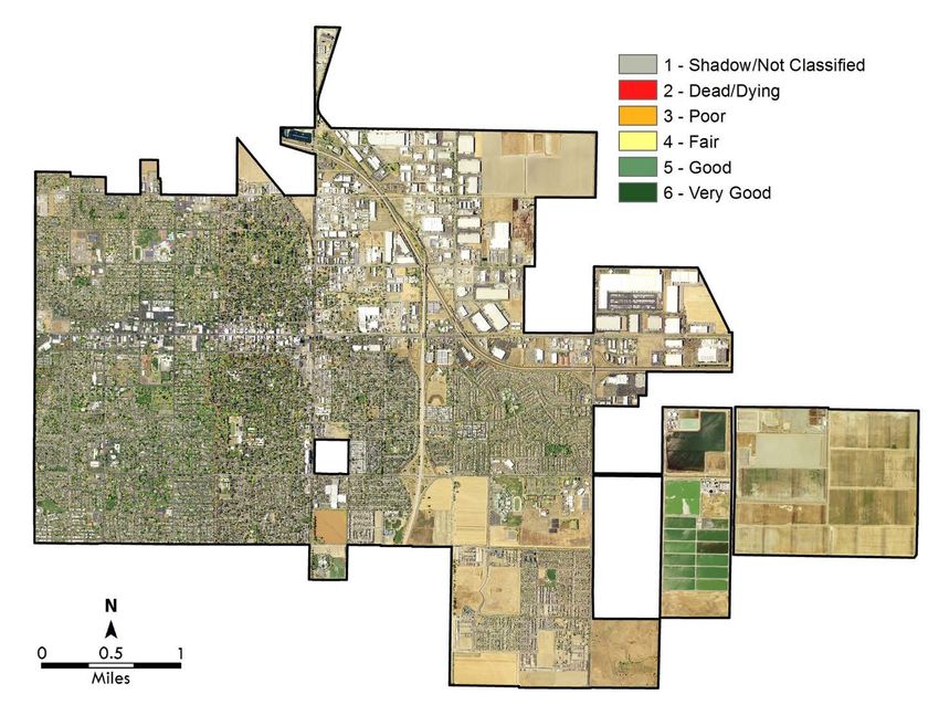
Tree Canopy Health
   Canopy health can be determined using near-infrared imagery and Normalized Difference
   Vegetation Index (NDVI) transformation. NDVI values are averaged over time to establish
   normal growing conditions in a region.
   Further analysis can then characterize the
   health of vegetation relative to the
   established normal condition. This allows
   identification of where plants are in very
   good condition, and where they are in
   decline. The results of this analysis provided
   detail canopy health information when
   viewed and analyzed in GIS software.
   In Woodland, 73.2% of the canopy is
   comprised of trees in fair or better
   condition. Healthy trees are vigorous, often
   producing more leaf surface area each         The UTC Tree Canopy Health analysis provides
   year. 14.8% of Woodland’s canopy is                       a detailed GIS layer.
   made up of trees in poor condition or dead
   or dying. The remaining 11.9% from this analysis are considered shadows or unclassified. This
   important baseline data can contribute to understanding forest health over time. The data can
   also be used as a comparison should emerging pests or disease become an issue.

                             Very Good                   Shadow/Not
                              21.64%                      Classified
                                                           11.94%
                                                               Dead/Dying
                                                                 3.67%

                                                                Poor
                                                               11.15%

                           Good                            Fair
                          32.18%                          19.42%

                              Figure 7: Summary of Canopy Health

                              Table 3: Summary of Canopy Health
                             Heath Rating          Acres   %
                             Shadow/Not Classified   167 11.94
                             Dead/Dying               51 3.67
                             Poor                    155 11.15
                             Fair                    271 19.42
                             Good                    449 32.18
                             Very Good               302 21.64
                             Total                 1,394 100%

13 Land Cover                                                                             2018
Map 2: Tree Canopy Health 2018 Land Cover 14
Tree Canopy by Council District
   Council District boundaries are often used to better understand the distribution of tree canopy,
   as they tend to reflect geographies that are recognized by community members and elected
   officials. Exploring canopy distribution and socioeconomic indicators at this level can help
   facilitate outreach and education activities as well as develop a deeper understanding of tree
   canopy at a meaningful scale.
   Woodland is divided into five (5) Council Districts (Map 3). The Second District has the greatest
   canopy cover (32.2%), followed by the First District (24.9%) and the Third District (24.9%). The
   Fifth district is the largest (3,414 acres) and has the lowest average canopy cover at 6.1%.
                              Table 4: Council District Summary by Acreage
                                                         Grass/Low    Bare            Preferred
   Council                Canopy   Canopy   Impervious                        Water               Potential
                  Acres                                  Vegetation    Soil           Plantable
   District                Acres      %       Acres                           Acres                 UTC
                                                           Acres      Acres             Acres
First District    1,125      281    24.95          655          138      51       1         189      41.72
Second District   1,111      358    32.21          619          119      15       0         134      44.25
Third District    1,021      255    24.97          576           87     103       0         189      43.52
Fourth District   2,956      291     9.84        1,755          110     788      10         898      40.21
Fifth District    3,414      209     6.13          892          250   1,807     248       2,057      66.39

                                        Aerial Image of Woodland

15 Land Cover                                                                                        2018
Map 3: Tree Canopy by Council District 2018 Land Cover 16
Tree Canopy by Zoning
               Zoned areas encompass 8,032 acres of the overall area in Woodland (9,624 acres). Open
               space (1,735 acres) encompasses the greatest area, followed by single family residential
               (1,714 acres), and industrial (1,696 acres). Single family residential areas have the greatest
               amount of tree canopy (531acres), but the highest canopy cover (39.8%) is found in areas with
               no designation followed by general commercial (37.3%). The Spring Lake Specific Plan refers
               to a parcel in south Woodland near the freeway that will be developed into private homes.
               This area is represented as public space on the map, but in the coming years will transition to
               residential.
                                                Table 5: Tree Canopy by Zoning
                                                                              Grass/Low     Bare               Preferred
                                               Canopy   Canopy   Impervious                           Water                Potential
Zoning Description                   Acres                                    Vegetation     Soil              Plantable
                                                Acres      %       Acres                              Acres                  UTC
                                                                                Acres       Acres                Acres

Open Space                          1,734.61    51.31    27.20      66.33       175.72     1,180.61   256.16   1,356.33     81.15
Single Family Residential           1,714.46   531.36     2.96     876.44       243.02       61.99      1.17     305.00     48.78
Industrial                          1,695.79    72.04    24.17     970.39        27.54      622.05      2.33     649.59     42.55
Spring Lake Specific Plan            932.11     44.64     4.79     282.75        82.13      522.59      0.00     604.72     69.67
Southeast Area Specific Plan         373.96     99.44    26.59     243.64        26.27        4.61      0.00      30.88     34.85
General Commercial                   287.10     41.15    37.30     183.65         5.95       56.35      0.00      62.30     36.03
Multi Family                         277.96     67.18    30.99     175.35        26.00        9.43      0.00      35.43     36.91
Duplex Residential                   222.87     83.14     6.93     103.22        28.79        7.72      0.00      36.51     53.68
Neighborhood Preservation            164.69     65.50    25.66      76.00        20.84        2.34      0.00      23.19     53.85
East Street District                 162.61     30.61     4.25      99.09        12.66       20.24      0.00      32.90     39.06
Central Business District            138.97     29.47     7.28      96.17        10.02        3.31      0.00      13.33     30.80
Entry Overlay-Industrial/Planned
Development                           91.69      6.68    19.98      48.54         1.43       35.05      0.00      36.48     47.06
Service Commercial                    87.33      6.05    18.82      34.90         1.92       43.82      0.00      45.74     59.31
Entry Overlay                         73.18      6.50    14.33      55.40         1.57        9.67      0.00      11.24     24.24
Highway Commercial                    41.64      8.32     8.88      25.61         0.39        7.32      0.00       7.71     38.50
Agriculture                           14.32      0.68     4.76       4.15         2.61        6.87      0.00       9.48     71.00
Right of Way                           9.22      0.97    17.11       4.52         0.75        2.97      0.00       3.73     50.97
No Designation                         4.48      1.22    39.77       2.08         0.34        0.83      0.00       1.18     53.46
Neighborhood Commercial                3.11      0.80    21.21       2.15         0.16        0.00      0.00       0.16     30.83
Single Family Residential/Planned
Development                            2.25      0.38    10.52       1.05         0.05        0.77      0.00       0.82     53.39

        17 Land Cover                                                                                                2018
Map 4: Woodland Zoning 2018 Land Cover 18
Tree Canopy by Tree Maintenance Zone
     The City of Woodland has divided the community into 25 Maintenance Zones. Of these, Zone
     4 and Zone 25 have highest overall acreage, but both zones are among the lowest for canopy
     cover at 8.2% and 5.2%. Zone 18 has the highest canopy cover at 38.1%. Zone 5 has the
     lowest canopy cover at 4.7% and a maximum potential for 30.9% tree canopy. Zone 25, which
     currently has 5.2% canopy cover has a potential canopy cover of 65.8% and 680.85 acres of
     preferred plantable area.
                             Table 6: Tree Canopy by Maintenance Zone
                                                        Grass/Low     Bare            Preferred
Maintenance              Canopy   Canopy   Impervious                         Water               Potential
                Acres                                   Vegetation     Soil           Plantable
Zones                     Acres     %        Acres                            Acres                 UTC
                                                          Acres       Acres             Acres
1               229.06    51.50   22.48      140.27        15.88      20.86    0.00     36.73      38.52
2               160.18    42.73   26.68       93.84        12.20      11.41    0.00     23.61      41.42
3               206.19    57.15   27.72       82.37        14.64      51.79    0.00     66.43      59.94
4                1,414   116.41    8.23      903.22        25.56     355.87   10.50    381.43      35.21
5               507.59    24.06    4.74      347.14        19.19     114.02    0.00    133.21      30.98
6               160.76    54.91   34.16       87.72        15.79       2.34    0.00     18.13      45.43
7               159.81    47.79   29.91       89.85        18.48       3.69    0.00     22.17      43.78
8               243.92    49.23   20.18      160.67        26.66       7.37    0.00     34.02      34.13
9               235.69    47.83   20.29      140.88        21.21      25.78    0.00     46.99      40.23
10              184.20    45.67   24.79      114.06        21.76       2.72    0.00     24.47      38.08
11              187.94    46.58   24.78      100.29        24.85      16.22    0.00     41.07      46.64
12              162.25    59.26   36.52       86.35        14.06       2.59    0.00     16.65      46.78
13              161.51    50.54   31.29       96.09        12.77       2.11    0.00     14.88      40.50
14              402.52    77.00   19.13      240.17        34.13      51.21    0.00     85.34      40.33
15              634.85   132.17   20.82      425.36        28.51      48.81    0.00     77.32      33.00
16              526.18    67.54   12.84      252.10        57.44     149.04    0.00    206.48      52.08
17              160.71    60.41   37.59       81.32        18.10       0.88    0.00     18.98      49.40
18              159.71    60.91   38.14       72.56        24.44       1.80    0.00     26.24      54.57
19              135.66    36.07   26.59       81.37        17.40       0.83    0.00     18.22      40.02
20              134.56    36.53   27.15       79.23        14.66       3.44    0.69     18.10      40.60
21              160.46    33.58   20.93       95.69        23.13       7.83    0.21     30.97      40.23
22              160.81    48.49   30.16       88.26        19.44       4.12    0.39     23.56      44.81
23              164.99    41.95   25.43      104.65        16.84       1.56    0.00     18.39      36.57
24              156.51    41.50   26.52       95.16        17.81       1.98    0.00     19.80      39.16
25            1,123.86    58.74    5.23      381.37        59.33     621.51    0.00    680.85      65.81

19 Land Cover                                                                                       2018
Map 5: Tree Canopy by Maintenance Zone 2018 Land Cover 20
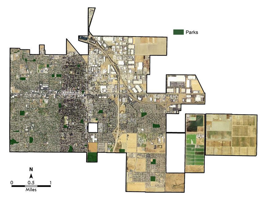
Canopy Cover by Parks
        The City of Woodland has 33 areas designated as parks. The form and use of these areas
        varies from ball fields to detention ponds to open green spaces. The availability of space to
        plant trees is limited by these types of parks. For example, ball fields are unsuitable sites for
        trees. These areas are not included in the later planting priority analysis. However, they are
        included in this parks land cover analysis.
        Of Woodland’s 33 parks, the top ten largest by acreage are summarized in Table 7.
        Woodland’s largest park is Woodland Community & Senior Center, which encompasses 43
        acres with two (2) acres of canopy cover, or 4.02%, with a maximum UTC of 58.4%, which
        suggests that there is a large of area suitable for planting trees. John Ferns Park has the
        greatest percent canopy at 41.5%, but still has a maximum UTC of 83.4%. Other parks have
        lower maximum UTC percentages, possibly due to impervious surfaces or the presence of fields,
        which are not suitable sites for planting and were not considered in the preferred plantable
        acreage.
                          Table 7: Canopy Cover in Woodland’s Top Ten Largest Parks
                                                                    Grass/Low    Bare            Preferred
                                    Canopy   Canopy    Impervious                        Water               Maximum
Park                        Acres                                   Vegetation    Soil           Plantable
                                     Acres     %         Acres                           Acres                 UTC
                                                                      Acres      Acres             Acres
Woodland Community &
                            43.39    1.74      4.02       12.63        11.07     12.51   0.00      23.58      58.37
Senior Center
Dave Douglass Park          12.84    0.73       5.68       2.13         8.09      1.89   0.00      9.98       83.38
Rick Gonzales, Sr. Park     10.14    0.01       0.06       0.13         0.00     10.00   0.00     10.00       98.70
Pioneer Park                10.05    2.65     26.38        1.84         5.56      0.00   0.00      5.56       81.68
John Ferns Park              9.29    3.85     41.48        1.54         3.66      0.23   0.00      3.90       83.43
Crawford Park                8.27    2.01     24.30        2.62         3.40      0.24   0.00      3.64       68.33
Woodside Park                8.21    3.25     39.62        1.24         3.00      0.60   0.12      3.60       83.44
Jack Slaven Park             7.95    0.32       4.05       1.34         5.01      1.28   0.00      6.28       83.14
Spring Lake Park             7.55    0.00       0.00       0.00         1.83      5.72   0.00      7.55      100.00
Dick Klenhard Park           7.24    1.47     20.27        1.58         3.49      0.70   0.00      4.19       78.20
All other parks             54.68   19.20     35.11        9.39        23.70      6.18   0.00     26.10       82.83
All parks total             179.6   35.24    19.62%       34.44        68.81     35.56   0.12    104.37      77.73%

                    Woodland has 1,394 acres of canopy or 14.5% of the overall land cover

   21 Land Cover                                                                                             2018
Map 6: Woodland Parks 2018 Land Cover 22
Land Cover by Landscape and Lighting Districts
   Woodland has 7 Landscape and Lighting Districts (LL Districts), which are fee districts within
   Woodland that support tree care. Of these districts, the Spring Lake Assessment District has the
   greatest acreage with 393 acres, a canopy cover of approximately 5.9%, and a maximum
   UTC of 56.3%. The Spring Lake Maintenance Community Facilities District has the greatest
   maximum UTC at 83.4%, with 133 total acres and 109 preferred plantable acres. The
   Gateway Landscaping and Lighting District is the smallest with less than one (1) acre and the
   smallest UTC, because most of the acreage is made up of impervious surface 93.3%.
                          Table 8: Canopy Cover by Landscape and Lighting Districts

                                                              Grass/Low    Bare    Preferred   Preferred
                               Canopy   Canopy   Impervious                                                Maximum
Name                  Acres                                   Lying Veg.   Soil    Plantable   Plantable
                                Acres     %          %                                                       UTC
                                                                  %         %          %         Acres

Spring Lake
Assessment            392.73    23.23     5.92        43.73        5.52    44.83      50.35      197.74       56.27
District
Gibson
Ranch/SEA
                      344.18    92.68    26.93        64.70        7.40     0.97       8.37       28.82       35.30
Landscaping and
Lighting District
Spring Lake
Maintenance
                      132.70     1.76     1.33        16.61        4.55    77.51      82.06      108.89       83.39
Community
Facilities District
Streng Pond
Landscaping
                       34.15    10.04    29.39        47.94       16.64     4.69      21.34        7.29       50.73
Maintenance
District
North Park
Landscaping and        23.04     6.30    27.34        56.23       10.45     5.98      16.43        3.79       43.77
Lighting District
Westwood
Landscaping and         4.85     1.05    21.66        67.93        9.11     1.29      10.40        0.50       32.07
Lighting District
Gateway
Landscaping and         0.88     0.01     1.33        93.25        5.32     0.00       5.32        0.05        6.65
Lighting District

23 Land Cover                                                                                                 2018
Canopy Cover Comparison with Neighboring Communities
Woodland has approximately 14.5% canopy cover. Of neighboring communities (Figure 6),
Citrus Heights has the highest canopy cover at 25.0%.
Citrus Heights, CA 25.00%
Elk Grove, CA 22.88%
Patterson, CA 21.30%
Municipality
Sacramento, CA 19.20%
Roseville, CA 15.70%
Woodland, CA 14.49%
0% 5% 10% 15% 20% 25% 30%
Canopy Cover %
Figure 8: Neighboring Municipalities Canopy Coverage Comparison
Street Trees in Downtown Woodland
2018 Land Cover 24Historic Change
Canopy data derived from 2009 NAIP imagery was used to determine change over the seven-
year period. The 2009 canopy data was summarized for all features in each feature class data
layer. Geospatial processing was conducted to get the acreages and percentages. These values
were compared to the 2016 NAIP imagery to determine change acres, change percent, and
absolute change. The accuracy of change acres and percentages were based on the accuracy
of the 2009 tree canopy dataset.
Table 9: Historic Canopy Cover
Canopy Acres Canopy %
Canopy 2009 667 6.93
Current Canopy 1,394 14.49
Woodland encompasses 9,624 acres with a tree canopy that currently covers 1,394 acres or
14.5% of the overall land cover. In 2009, the tree canopy was only 667 acres, which at the
time was 6.9% of the land cover. The change in canopy acreage from 2009 to today is 727
acres or a 108.9% increase in canopy cover.
2009 Canopy % Current Canopy %
45% 41%
40%
40%
35%
Canopy Cover %
35%
30% 26%
24% 24% 23% 24% 24%
25% 20% 19% 18%
20% 16% 15%
14%
15%
10% 6% 6%
4% 4%
5% 2%
0%
Pioneer Park
Dave Douglass Park
Woodside Park
Crawford Park
Christiansen/Camarena Park
John Ferns Park
Woodland Community & Senior
Dick Klenhard Park
Harris Park & Harris Field
Campbell Park
Center
Park Name
Figure 9: Woodland’s Top 10 Largest Parks - Historic Tree Canopy Change from 2009
Comparing present day findings to those of the 2009 canopy assessment conducted by DRG,
we can compare tree canopy in parks and tree maintenance zones to better understand the
changes in the urban canopy.
Figure 9 shows the top 10 largest parks (that existed in 2009 and currently) and compares
historical and current canopy cover. Currently, parks encompass nearly 180 acres with over 35
acres of canopy cover. In 2009, Woodland parks encompassed approximately 162 acres of
total area and 20 acres of canopy cover. Since 2009, Woodland has added 4 parks and the
25 Land Cover 2018average park canopy acreage increased from 0.7 acres to 1.2 acres. Although, parks represent
a fraction of Woodland, comparing current tree canopy acreage with 2009 data provides a
visual for the changes in Woodland’s urban tree canopy. Further, this historical park analysis
highlights continued areas of opportunity for expanding the canopy through parks in
Woodland.
Another useful historical comparison is between Tree Maintenance Zones. Unlike Woodland
parks, the Tree Maintenance Zones have not changed in total acreage since the 2009
assessment, but canopy cover has increased from nearly 665 acres to approximately 1,389
acres, since 2009. Figure 10 shows that all Tree Maintenance Zones experienced positive
changes in canopy cover. On average, each Tree Maintenance Zone saw an increase of 28.9
acres of tree canopy. Tree Maintenance Zones 4, 15, and 25 experienced the most gains in
canopy acreage, with Zone 4 increasing by nearly 64 acres (1.2%), Zone 15 increasing by
nearly 108 acres (4.4%), and Zone 25 increasing by over 50 acres (5.8%).
1% 2009 Canopy % Current Canopy %
25 5%
24 15%
27%
23 15%
25%
22 18%
30%
21 12%
21%
20 13%
27%
19 18%
27%
18 25%
38%
17 22%
38%
16 5%
13%
15 4%
21%
14 9%
19%
13 18%
Tree Maintenance Zones
31%
12 21%
37%
11 14%
25%
10 12%
25%
9 11%
20%
8 10%
20%
7 18%
30%
6 20%
34%
5 1%
5%
4 4%
8%
3 14%
28%
2 13%
27%
1 11%
22%
0% 5% 10% 15% 20% 25% 30% 35% 40% 45%
% Canopy Cover
Figure 10: Tree Maintenance Zone Acreage - Historic Tree Canopy Change from 2009
2018 Land Cover 26Preferred Planting Sites
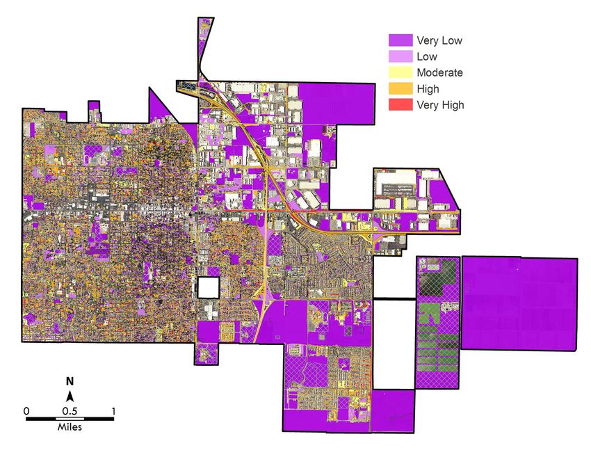
Woodland has 3,469.49 acres of preferred plantable acres. To identify and prioritize planting
potential, DRG assessed environmental features to identify and prioritize the risk potential for
soil loss and degradation from storm and flood events. Weighted consideration was provided
for proximity to hardscape and canopy, soil permeability, location within a floodplain, slope,
population density, road density, and a soil erosion factor (K-factor) (Table 10). Each feature
was assessed using a separate grid map. A value between zero (0) and four (4) (with zero (0)
having the lowest risk potential) was assigned to each feature/grid assessed. Overlaying these
grid maps and averaging the values provided the risk potential at any given point. A priority
ranging from very low to very high was assigned to areas on the map based on the calculated
average.
Table 10: Stormwater Factors Used to Prioritize Tree Planting Sites
Dataset Source Weight
Proximity to Hardscape Urban Tree Canopy Assessment 0.30
Soil Permeability Natural Resource Conservation Service 0.20
Soil Erosion (K-factor) Natural Resource Conservation Service 0.20
Canopy Fragmentation Urban Tree Canopy Assessment 0.30
While available planting sites may ultimately be planted over the next several decades, the
trees that are planted in the next several years, should be planned for areas of greatest need,
and where they will provide the most benefits and return on investment.
The analysis identified the following acres of planting:
• Very Low–2,765 acres
• Low–183 acres
• Moderate–206 acres
• High–252 acres
• Very High–58 acres
Table 11: Priority Planting by Land Use
Priority Very Low Low Moderate High Very High
Planting Priority Priority Priority Priority Priority
Land Use Total Acres Acres Acres Acres Acres Acres
Public Lands 956.66 806.83 71.21 42.94 30.05 4.64
Private Lands 611.97 276.15 58.27 98.85 142.26 36.44
Commercial Properties 747.42 604.71 41.39 49.98 44.63 6.71
Other 888.68 887.11 0.03 0.60 0.91 0.00
Total 3,204.73 2,574.81 170.89 192.36 217.85 47.79
Note that the priority planting total in Table 11 is less than the citywide total of 3,469 plantable
acres. The discrepancy can be attributed to planting sites located in the rights-of-way, mainly
around interstate/highway interchanges.
27 Land Cover 2018Map 7: Planting Priority 2018 Land Cover 28
Conclusion
   Since 2009, overall tree canopy has increased city-wide by 727 acres (109%). This increase in
   canopy (the amount of canopy that covers the ground, when viewed from aerial photography)
   can come from the planting of new trees and the continued growth of existing trees. Since 2009
   four (4) parks were added; Avignon Park, Jack Slaven Park, Spring Lake Park, and Rick
   Gonzales Senior Park. The average park canopy acreage increased from 0.7 acres to 1.2
   acres. Tree Maintenance Zones in Woodland also increased tree canopy with nearly 724 acres
   added since 2009. Because the urban forest is a dynamic, growing, and ever-changing resource
   it will continue to require sound and proactive management to fully realize its maximum
   potential.
   The UTC Assessment establishes a new baseline for monitoring overall tree canopy cover
   throughout the community and augments the City's GIS database with a landcover layer that
   identifies the location and extent of existing canopy. This data layer can be used in conjunction
   with other infrastructure layers to prioritize planting sites and increase canopy cover
   strategically by neighborhood, park, or land use. This assessment provides a foundation for
   developing urban forest management strategies and measuring the success of those strategies
   over time.
   With an average overall canopy of 14.5% and a maximum UTC potential 50.5%, Woodland
   has ample opportunity to expand the urban forest. Community engagement and support are
   vital to a successful urban forestry program. Based on this assessment, urban forest managers
   have the following opportunities:
       •   Considering that 46.8% of Woodland is covered by impervious surface and that the
           current canopy cover is 14.5% with 7.3% cover by grass and low-lying vegetation
           and 28.7% by bare soil, the potential UTC is 50.5%. Given the maximum potential
           UTC of 50.5%, the community must decide what is a reasonable UTC goal for their
           needs.
       •   Prioritized maps provide a basis for a strategically focused planting plan to increase
           trees and canopy that will support stormwater management, preserve soil, and
           complement the existing urban infrastructure for the greatest impact and return on
           investment. These prioritized maps exclude open spaces that will never get planted,
           such as athletic fields.
       •   Among the top 10 largest parks in Woodland, all have a potential UTC above 58%,
           with nearly 78 acres of preferred planting sites, which could be a fantastic
           opportunity for adding large-stature shade trees.
       •   Incentivize tree planting on private property, particularly in high and very high
           priority planting areas. An area that could benefit from this incentive is Maintenance
           Zone 25 with a potential UTC of 65.8%, with 681 acres of preferred plantable acres.

29 Conclusion                                                                                 2018
Tree canopy, since 2009, has increased city-wide by 727 acres. 2018 Conclusion 30
Appendix A: References
   Akbari, H., D. Kurn, et al. 1997. Peak power and cooling energy savings of shade trees. Energy
   and Buildings 25:139–148.
   CUFR. Center for Urban Forest Research. USDA Forest Service Pacific Southwest Research
   Station. http://www.fs.fed.us/psw/programs/cufr/
   Clark JR, Matheny NP, Cross G, Wake V. 1997. A model of urban forest sustainability. Journal
   of Arboriculture 23 (1): 17-30.
   Heisler GM. 1986. Energy Savings with Trees. J Arbor 12 (5): 113–125.
   Hirabayashi, S. 2014. i-Tree Canopy Air Pollutant Removal and Monetary Value Model
   Descriptions. http://www.itreetools.org/canopy/resources/iTree_Canopy_Methodology.pdf
   [Accessed 26 Sept 2017]
   i-Tree Canopy v6.1. i-Tree Software Suite. [Accessed 26 Sept. 2017] www.itreetools.org/canopy
   i-Tree Hydro v5.0. i-Tree Software Suite. [Accessed 26 Sept 2017] www.itreetools.org/hydro/index.php
   Karl, Tom, P. Harley, L. Emmons, B. Thornton, A. Guenther, C. Basu, A. Turnipseed, K. Jardine.
   Efficient Atmospheric Cleansing of Oxidized Organic Trace Gases by Vegetation. October
   2010. http://www.sciencemag.org/cgi/content/abstract /330/6005/816
   McPherson, E.G.; Simpson, J.R.; Peper, P.J.; Xiao, Q. 1999. Tree Guidelines for San Joaquin
   Valley Communities. U.S. Department of Agriculture, Forest Service, Pacific Southwest Research
   Station, Center for Urban Forest Research.
   McPherson, EG., Xiao, Xl, Maco, S.E., Van Der Zanden, A., Simpson, J.R., Bell, N., Peper, P.J.
   2002 Western Washington and Oregon Community Tree Guide: Benefits, Costs and Strategic
   Planting. Center for Urban Forest Research Pacific Southwest Research Station. Fs.fed.us/psw
   U.S. Environmental Protection Agency (US EPA). 2012. Environmental Benefits Mapping and
   Analysis Program (BenMAP). http://www.epa.gov/air/benmap [Accessed 26 Sept 2017]
   U.S. Forest Service. 2012. STRATUM Climate Zones. [Accessed 26 Sept 2017]
   http://www.fs.fed.us/psw/programs/uesd/uep/stratum.shtml
   Xiao, Q., McPherson, E.G., Simpson, J.R., Ustin, S.L. 1998. Rainfall Interception by Sacramento's
   Urban Forest. Journal of Arboriculture. 24(4): 235-244.

31 Appendix A: References                                                                           2018
Appendix B: Methodology
  Calculating Benefits
  Air Quality
  The i-Tree Canopy v6.1 Model was used to quantify the value of ecosystem services for air
  quality. i-Tree Canopy was designed to give users the ability to estimate tree canopy and other
  land cover types within any selected geography. The model uses the estimated canopy
  percentage and reports air pollutant removal rates and monetary values for carbon monoxide
  (CO), nitrogen dioxide (NO2), ozone (O3), sulfur dioxide (SO2), and particulate matter (PM)
  (Hirabayashi 2014).
  Within the i-Tree Canopy application, the U.S. EPA’s BenMAP Model estimates the incidence of
  adverse health effects and monetary values resulting from changes in air pollutants
  (Hirabayashi 2014; US EPA 2012). Different pollutant removal values were used for urban and
  rural areas. In i-Tree Canopy, the air pollutant amount annually removed by trees and the
  associated monetary value can be calculated with tree cover in areas of interest using BenMAP
  multipliers for each county in the United States.
  To calculate ecosystem services for the study area, canopy percentage metrics from UTC land
  cover data performed during the assessment were transferred to i-Tree Canopy. Those canopy
  percentages were matched by placing random points within the i-Tree Canopy application.
  Benefit values were reported for each of the five listed air pollutants.

  Carbon Storage and Sequestration
  The i-Tree Canopy v6.1 Model was used to quantify the value of ecosystem services for carbon
  storage and sequestration. i-Tree Canopy was designed to give users the ability to estimate
  tree canopy and other land cover types within any selected geography. The model uses the
  estimated canopy percentage and reports carbon storage and sequestration rates and
  monetary values. Methods on deriving storage and sequestration can be found in (Nowak et al,
  2013).
  To calculate ecosystem services for the study area, canopy percentage metrics from UTC land
  cover data performed during the assessment were transferred to i-Tree Canopy. Those canopy
  percentages were matched by placing random points within the i-Tree Canopy application.
  Benefit values were reported for carbon storage and sequestration.

  Stormwater
  The i-Tree Hydro v5.0 Model was used to quantify the value of ecosystem services for
  stormwater runoff. i-Tree Hydro was designed for users interested in analysis of vegetation and
  impervious cover effects on urban hydrology. This most recent version (v5.0) allows users to
  report hydrologic data on the city level rather than just a watershed scale giving users more
  flexibility. For more information about the model, please consult the i-Tree Hydro v5.0 manual
  (http://www.itreetools.org).
  To calculate ecosystem services for the study area, land cover percentages derived for the
  project area and all municipalities that were included in the project area were used as inputs
  into the model. Precipitation data from 2005-2012 was modeled within the i-Tree Hydro to
  best represent the average conditions over an eight-year time period. Model simulations were
  run under a Base Case as well as an Alternate Case. The Alternative Case set tree canopy

2018                                                              Appendix B: Methodology 32
You can also read