Noosa Area - Draft Resource Information 2021 - Queensland ...
←
→
Page content transcription
If your browser does not render page correctly, please read the page content below
Department of Environment and Science

Noosa Area
Incorporates: Noosa National Park, Noosa Conservation Park, Weyba Creek Conservation Park,
Keyser Island Conservation Park

                                        Draft Resource Information
                                                                                         2021
                                                               Not Government Policy
This resource information document has been prepared by Queensland Parks and Wildlife Service &
Partnerships (QPWS&P), Department of Environment and Science

© State of Queensland, 2021

March 2021
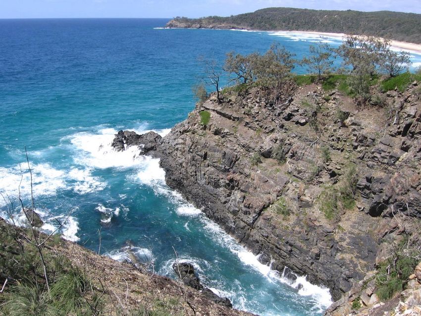
Front cover photo: Noosa National Park © Queensland Government

The Queensland Government supports and encourages the dissemination and exchange of its information.
The copyright in this publication is licensed under a Creative Commons Attribution 3.0 Australia (CC BY)
licence.

Under this licence you are free, without having to seek our permission, to use this publication in accordance
with the licence terms.

You must keep intact the copyright notice and attribute the State of Queensland as the source of the
publication, and the Kabi Kabi Peoples as the copyright owner in relation to traditional cultural knowledge
sections of the publication, as well as acknowledging the Kabi Kabi Peoples as the source of that traditional
cultural knowledge and site identification information contained in the publication.
For more information on this licence, visit http://creativecommons.org/licenses/by/3.0/au/deed.en

Disclaimer
This document has been prepared with all due diligence and care, based on the best available information at
the time of publication. The department holds no responsibility for any errors or omissions within this
document. Any decisions made by other parties based on this document are solely the responsibility of those
parties.

If you need to access this document in a language other than English, please call the Translating and
Interpreting Service (TIS National) on 131 450 and ask them to telephone Library Services on +61 7 3170
5470.

This publication can be made available in an alternative format (e.g. large print
or audiotape) on request for people with vision impairment; phone +61 7 3170
5470 or email .
Public consultation on planning documents
Good planning is an important part of effective park management: it helps us understand where we are
now, where we want to be, and how we are going to get there. It is the first step in the Values-Based
Management Framework, an adaptive management cycle used by the Queensland Parks and Wildlife
Service & Partnerships (QPWS&P) for setting the goals, strategic direction and priorities for park
management. The cycle incorporates phases of monitoring, evaluating and reporting to inform how we
are performing and where we need to adapt management to achieve our goals and good outcomes for
Queensland’s parks, forests and reserves.
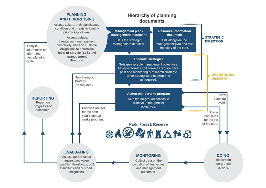
Planning for each park is brought together
and communicated through several
planning documents: management plans
and statements, resource information,
thematic strategies, and action plans. The
hierarchy and purpose of these documents
are shown in Figures 1 and 2.
For Noosa Area, the following planning
documents are available:
draft management plan
draft resource information
document
An invitation to comment
Organisations and members of the public
are encouraged to have a say on the
management of the Noosa Area: you are
invited to review the management plan and
resource information documents and put
forward a submission.
Written submissions can be made via the
Queensland Government’s Get Involved
website www.getinvolved.qld.gov.au.
The Minister will consider all submissions
when finalising the management plan.
For further information on the planning
process, please visit the Department of Figure 1. Hierarchy of planning documents and their purpose
Environment and Science’s website
www.des.qld.gov.au.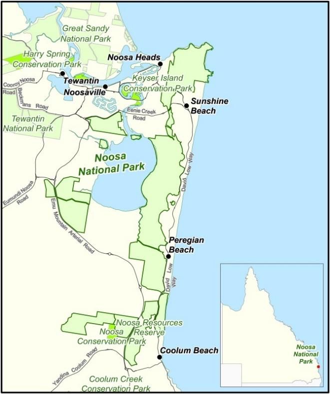
Contents
1. Introduction ...........................................................................................................................................2
2. Noosa Area ............................................................................................................................................3
   2.1 Ecosystems and biodiversity ........................................................................................................4
       2.1.1 Closed forest                                                                                                                                   4
       2.1.2 Eucalyptus racemosa mid-high/tall open forest and woodland                                                                                      4
       2.1.3 Melaleuca quinquenervia mid-high/tall open forest and woodland                                                                                  4
       2.1.4 Callitris mid-high/tall open forest                                                                                                             4
       2.1.5 Banksia integrifolia/Casuarina equisetifolia low/mid-high open forest/woodland                                                                  4
       2.1.6 Open/closed heath (high dunes)                                                                                                                  4
       2.1.7 Closed heath/sedgelands                                                                                                                         4
       2.1.8 Open heath (rocky hills)                                                                                                                        5
   2.2 Species ............................................................................................................................................5
       2.2.1 Native animals                                                                                                                                  5
       2.2.2 Native plants                                                                                                                                   5
   2.3 Geophysical features .....................................................................................................................6
   2.4 Recreational opportunities ............................................................................................................6
       2.4.1 Noosa Headland section                                                                                                                          6
       2.4.2 Lake Weyba park sections                                                                                                                        6
   2.5 Ecotourism ......................................................................................................................................7
   2.6 Historic cultural heritage ...............................................................................................................7
   2.7 Partnerships ....................................................................................................................................7
       2.7.1 Local councils                                                                                                                                  7
       2.7.2 Noosa Parks Association                                                                                                                         7
   2.8 Scientific research ..........................................................................................................................8
   2.9 Education ........................................................................................................................................8
   2.10 Fire .................................................................................................................................................8
   2.11 Pests ..............................................................................................................................................9
       2.11.1 Pest plants                                                                                                                                    9
       2.11.2 Pest animals                                                                                                                                   9
Appendices .............................................................................................................................................10
   Appendix 1. Legal, policy and management commitments ...........................................................10
   Appendix 2. Regional ecosystems of significance .........................................................................11
   Appendix 3. Species of conservation significance .........................................................................12
   Appendix 4. Species listed in international agreements ................................................................14
   Appendix 5. Places of historic value ................................................................................................15
   Appendix 6. Pests ...............................................................................................................................16
References ..............................................................................................................................................18

                                                                              1
Noosa Area DRAFT Resource Information
1. Introduction
The Department of Environment and Science recognises, respects and values
First Nations peoples and cultures. We recognise First Nations rights and interests in
the Country on which we walk, work and live. We are committed to progressing
self-determination by working in genuine partnerships with First Nations peoples to
incorporate their priorities and perspectives across our decision-making and
operations. The Gurra Gurra Framework 2020-2026 prioritises and accelerates this
commitment, guiding the agency to embed Country and people at the centre of
all that we do.
The Queensland Parks and Wildlife Service & Partnership’s (QPWS&P) management planning process
aligns with the Values-Based Management Framework (VBMF), an adaptive management cycle that
incorporates planning, prioritising, doing, monitoring, evaluating and reporting into all areas of our
business (Figure 2). Management plans and statements set the strategic management direction,
guiding the next tier of planning and the development of thematic strategies, which in turn inform and
prioritise our on-ground operations.
Resource information is a compendium of park information and a supporting document for management
plans and management statements. It contains background information about a park’s purpose, values,
resources and legal and administrative framework.
Information about the Values-Based Management Framework is available on the Department of
Environment and Science (DES) website at www.des.qld.gov.au.
Figure 2. Phases of the VBMF cycle for planning and the hierarchy of planning documents
22. Noosa Area
The Noosa Area parks form a valuable natural
asset that conserves a near-continuous belt of
coastal vegetation communities along the
Sunshine Coast, from Coolum in the south to
Noosa Heads in the north. They preserve and
protect a diverse range of native plant and
animal species and a wide array of regional
ecosystems.
The whole Noosa Area lies within the lands of
the Kabi Kabi People. There is currently no
Indigenous land use agreement (ILUA) covering
the Noosa Area, but the Kabi Kabi People have
a Native Title claim that covers the area.
Encroaching urbanisation upon the coastal
native vegetation and landscape highlights the
parks’ regional significance for protecting and
conserving the remaining coastal ecosystems
and cultural heritage.
The heathlands of these parks are one of the
few remaining coastal areas providing core
habitat for the ground parrot Pezoporus wallicus
wallicus. After the Cooloola area, the heath of
Figure 3. Noosa Area location map.
the Noosa and Coolum regions is the next most
important in size and diversity on the Sunshine beaches and surfing while offering a unique
Coast. Coastal lowland vine forests, that are nature and culture combination.
remnant and nationally critically endangered
(Environment Protection and Biodiversity Noosa National Park is a green space in a
Conservation Act 1999 (Cwlth)), are found in highly urbanised area that has high aesthetic
moist gullies and on sheltered slopes. value and provides refuge for species. Its
proximity to surrounding townships presents a
The Noosa Area is internationally recognised as valuable opportunity to display the intrinsic
one of south-east Queensland’s major centres values of these natural coastal areas to the
of economic, social and recreational activity. broader community and encourage a respect
One of the principal attractions within Noosa for, and a desire to conserve, the area in its
National Park is the iconic Noosa Headland, natural state.
with its impressive coastal views, rocky
headlands, sandy shorelines and recreational Noosa Resources Reserve is a small strip of
opportunities drawing more than one million land (0.22ha) in the West Coolum section of the
visitors a year. The walking tracks provide Area, which includes a water and sewage pipe
opportunities for scenic viewing and access to that runs adjacent to Ridges Boulevard.
Bioregion Southeast Queensland
Area 2883ha
Noosa Shire Council and Sunshine Coast Noosa, Maroochydore and
Local Government Area State electorate
Regional Council Nicklin
Japan-Australia Migratory Bird Agreement (JAMBA)
China-Australia Migratory Bird Agreement (CAMBA)
Republic of Korea-Australia Migratory Bird Agreement (ROKAMBA)
Convention on the Conservation of Migratory Species of Wild Animals (CMS)
National recovery plan for Acacia attenuata
Management obligations
National recovery plan for the Mt Emu she-oak Allocasuarina emuina
National recovery plan for the black-breasted button-quail Turnix melanogaster
National recovery plan for the black-throated finch southern subspecies (Poephila cincta cincta)
Noosa Parks Association Inc. - manage the information/visitor centre at Noosa Headland under a
formal agreement
3Noosa Area DRAFT Resource Information
Keyser Island Conservation Park was formally 2.1.2 Eucalyptus racemosa
gazetted as Keyser Island Environmental Park
on 24 May 1986 under the Land Act 1962. At mid-high/tall open forest and
that time there was a Trustee Agreement with woodland
the Noosa Shire Council and the Department of
Primary Industries. In 1994 the environmental These communities are represented on the
park was gazetted as Keyser Island Noosa Headland and West Weyba sections of
Conservation Park under the Nature the park. They have been extensively cleared
Conservation Act 1992. south of Noosa and are of conservation
concern.
Weyba Creek Regional Park was formally
gazetted as Weyba Creek Environmental Park
on 3 December 1993 under the Land Act 1962. 2.1.3 Melaleuca quinquenervia
At that time there was a Trustee Agreement with mid-high/tall open forest and
Noosa Shire Council and the Director General of woodland
the Department of Primary Industries. In 1994
the environmental park was gazetted as Weyba These communities occur in patches throughout
Creek Conservation Park under the Nature Noosa National Park where they provide
Conservation Act 1992. protection for the Phaius orchids. On the
southern mainland, many of these communities
The legislative framework for managing the
have been extensively cleared for coastal
parks, designations over the parks, and
development. Samples present in the park
management obligations are outlined further in
represent a significant percentage of remaining
Appendix 1.
Sunshine Coast communities.
2.1.4 Callitris mid-high/tall open
forest
2.1 Ecosystems and Areas of Callitris open forest occur on the East
biodiversity Weyba section and Noosa Headland. This
community has limited distribution because of
clearing for residential development. It is very
The various sections of Noosa National Park
sensitive to fire and therefore requires special
conserve 33 distinct regional ecosystems which
management considerations.
represent the range of communities described
for the Sunshine Coast, three of which have
endangered biodiversity status and 15 that are 2.1.5 Banksia
considered to have ‘of concern’ biodiversity integrifolia/Casuarina
status, refer to Appendix 2. All of these
communities have either local, regional, equisetifolia low/mid-high open
conservation significance and/or conserve forest/woodland
species which are rare or threatened.
These foredune/beach ridge communities play a
fundamental role in foredune and headland
2.1.1 Closed forest stability. They are the most restricted of all
Coastal lowland warm subtropical rainforest coastal lowland habitats, with significant areas
growing on sand is conserved at Noosa remaining only on Moreton and Bribie Islands in
Headland in patches along the western South East Queensland.
boundary and in sheltered gullies. This
rainforest conserves the most southerly natural 2.1.6 Open/closed heath (high
occurrence of the kauri pine Agathis robusta and
several other plant species - the orchid
dunes)
Bulbophyllum globuliforme, a grass Arthraxon Small patches of high dune heath (Banksia
hispidus and the rainforest trees Cryptocarya aemula low closed heath and Banksia aemula
foetida and Symplocos harroldii. The only other low closed heath with Allocasuarina littoralis
significant areas conserving this rainforest type emergents) occur on the crests and exposed
in the South East Queensland biogeographic slopes of the oldest, largest Pleistocene dunes
region are at Cooloola and Fraser Island. in East Weyba and at the southern end of
Noosa Headland. It has been extensively
cleared for urban development and is
considered to be endangered.
2.1.7 Closed heath/sedgelands
4Noosa Area DRAFT Resource Information
Closed heath and sedgelands have high the eastern grass owl Tyto longimembris
conservation value as they provide one of the recorded from the East Weyba section in the
few remaining coastal areas supporting a wet heath/sedgeland or rank grassland
population of ground parrot Pezoporus wallicus. areas
After the Cooloola area, the wallum heath of the The wallum sedgefrog Litoria olongburensis
Noosa and Coolum regions is the next most inhabiting coastal heath communities
important (in size and diversity) of this plant local population of eastern grey kangaroos
community remaining on the Sunshine Coast. Macropus giganteus inhabiting the eastern
South of Noosa these regional ecosystems are and southern park sections around Lake
considered to be endangered. Weyba. They are not commonly found in
such coastal areas close to urban
2.1.8 Open heath (rocky hills) settlement
skink Ctenotus arcanus, which has a patchy
This community occurs on Cainozoic igneous distribution in south-east Queensland and is
rocks, especially rhyolite at Emu Mountain and unable to exist in urbanised areas
the rocky knoll on the West Weyba section. The freshwater crayfish Cherax sp. recorded in
community on Emu Mountain contains several the ephemeral streams and gullies of the
plant species restricted to these rocky habitats. coastal lowland rainforest at Noosa
Headland.
2.2.2 Native plants
2.2 Species In acquiring areas for national park on the
Sunshine Coast, efforts have been made to
conserve a representative sample of the
2.2.1 Native animals diversity of vegetation communities and plant
species present. The park supports a great
The diversity of vegetation communities within
diversity of native species including species of
Noosa National Park provides a broad range of
conservation significance, listed under the
habitats that support a great diversity of
Environment Protection and Biodiversity
invertebrate and vertebrate native animals,
Conservation Act 1999 (Cwlth) (Appendix 4).
including species of conservation significance.
More than 560 plant species have been
Native animal surveys have been carried out for
recorded in the park and adjacent areas.
the East Weyba and West Weyba sections and
Noosa Headland. More than 243 bird species Conservation significant flora recorded on the
have been recorded in the park and adjacent park include:
intertidal areas. The Noosa Headland area
provides habitat for 44 birds of conservation Mt. Emu she-oak Allocasuarina emuina
significance, including 26 migratory birds Mt. Coolum she-oak Allocasuarina
covered under agreements between Australia thalassoscopica
and Japan (JAMBA), Australia and China swamp stringybark Eucalyptus
(CAMBA), Australia and the Republic of Korea conglomerata
(ROKAMBA), and the Convention on the Phaius australis
Conservation of Migratory Species of Wild Acacia attenuata
Animals (CMS). stinking cryptocarya Cryptocarya foetida
Bulbophyllum globuliforme
Conservation significant fauna species recorded
Cryptostylis hunteriana
on the park (Environment Protection and
wallum leek orchid Prasophyllum wallum
Biodiversity Act 1999) are listed in Appendix 3.
Arthraxon hispidus
Species of local conservation significance tiny wattle Acacia baueri subsp. baueri
recorded on the park include: Christmas bells Blandfordia grandiflora.
koalas Phascolarctos cinereus inhabiting
Noosa Headland and its surrounds
a pair of visiting (possibly nesting) peregrine
falcons Falco peregrinus that have been
seen occasionally around Noosa Headland
5Noosa Area DRAFT Resource Information
barbecues. Existing public contact facilities
include a small information centre with
2.3 Geophysical interpretive and educational material, an outdoor
features amphitheatre, a twelve-sided shelter display
stand, some orientation signs, a visitor
information sheet and a self-guided walking
The Sunshine Coast, from Noosa to Coolum, is track.
characterised by a mosaic of distinct coastal
landforms including coastal plains, high dunes, Access to Tea Tree Bay is provided for disabled
headlands, foredunes, hills, and a tidal lake— persons via the Coast track. Water taps are
Lake Weyba. Noosa National Park’s soils are located at Laguna Bay and near Tea Tree Bay
low in nutrients and the vegetation types reflect and there are showers located at Laguna Bay
changes in soil-water relationships. only.
Most of the park complex lies on either
sandplains of Quaternary age (2 million years 2.4.2 Lake Weyba park sections
ago to present) or parabolic high dunes built up Access to this section of the park is from David
during the Pleistocene epoch (2 million to Low Way, at Marcus Beach, 2.5km north of
10,000 years ago). Exceptions to these Peregian Beach. Uncontrolled access and illegal
predominant geological forms include younger camping are occurring in the park areas
coastal beach sand ridges of Holocene age at surrounding Lake Weyba, resulting in littering
the Peregian section and the Myrtle Creek and degradation of the vegetation. Camping is
sandstones of Triassic-Jurassic age (248-144 inappropriate on any section of the park, and
million years ago) that underlie the North Weyba particularly on the Weyba sections, due to:
section and parts of Noosa Headland itself.
Noosa Headland is the most geologically poor drainage and susceptibility to
diverse section of the park, being formed mainly inundation precluding the establishment of
from Quaternary sand and sandstone with some any developed camping facilities
igneous intrusions. The igneous intrusions are the presence of ecologically sensitive areas
evident in the form of basaltic, granitic and such as the paperbark vegetation with
andesitic dykes cutting through the sandstone. rainforest understorey and the swamp
The intrusions and associated sandstone are orchid Phaius tancarvilleae areas
more resistant to erosion and consequently the degradation of the scenic value of the
have developed into rugged rocky points with lake foreshores
sheltered beaches in between. the availability of private camping facilities
nearby.
The West Weyba section of the park has an
unusual, partially vegetated, rhyolitic, rocky knoll Much of the East Weyba and Peregian sections
of volcanic origin present on the most westerly of the park were previously used as a military
boundary. artillery range. These areas contain dangerous
unexploded ordnance (UXO) such as artillery
and mortar shells and have been designated
contaminated land. Due to this, Lot 2 - Plan
SP177651, Lot 11 - Plan SP161940, and Lot
2.4 Recreational 147 - Plan NPW889 are areas of land
opportunities categorised by the Commonwealth Department
of Defence as having a 'substantial' potential to
be affected by residual UXO.
2.4.1 Noosa Headland section The presence of UXO necessitates restrictions
on public access for safety reasons. Restrictions
The main entry point to the national park is at
on access may also occur due to the area’s
Noosa Headland via Park Road. This area
cultural values, and liaison with Aboriginal
includes vehicle parking for visitors, an access
groups is essential before any access decisions
point for walking tracks, a picnic area, and an
are made. Only those tracks cleared for UXO
information centre. Many visitors come here to
will be used for walking tracks.
go walking, picnicking, and surfing. Access to
Noosa Headland also occurs via Viewland Drive Both the Peregian and Mount Emu sections are
to Laguna Lookout. Pedestrian access is accessed from David Low Way, north of Coolum
available at a number of points around the Beach.
perimeter of the headland, with the Park Road
boardwalk being the most commonly used.
Day-use facilities at Noosa Headland include a
picnic area with tables, toilets, bins and electric
6Noosa Area DRAFT Resource Information
2.5 Ecotourism 2.6 Historic cultural
heritage
The Sunshine Coast is a destination for both
Australian and international visitors. The area is The remains of a large mechanical winch on the
one of south-east Queensland’s major centres shore at Winch Cove (formerly called Machinery
of economic, social, and recreational activity. Bay) near Noosa Headland provide evidence of
One of the principal attractions is Noosa European settlement in the early twentieth
Headland. It is the most heavily used national century. The winch was either used by early
park in south-east Queensland, with estimates loggers to haul sawn hoop pines Araucaria
of use exceeding one million visitors per year. cunninghamii to the shore for transport by ship
As a major tourist destination, Noosa National to Brisbane or was salvaged from a foundering
Park has significant economic value for the vessel.
Sunshine Coast. Surrounding facilities such as
holiday apartments and lodges, campgrounds, During World War II (1939–45) trenches were
restaurants and kiosks gain economically from dug on Noosa Hill as part of a series of
tourism. fortifications for the Sunshine Coast. Slight dips
and piles of stones can still be seen today.
Visitors to Noosa National Park have a variety of During this period, the military used the eastern
opportunities, ranging from bushwalking through side of Lake Weyba as a firing range. This land
coastal rainforest, wallum heath, open forest was later declared State Forest and some
and grasslands, to family picnics, and observing limited logging occurred.
animals, plants, and the ocean life and
processes. The park provides a peaceful and The Noosa Area’s places of historic value are
scenic backdrop for coastal activities such as listed in Appendix 5.
surfing and fishing. There are also whale
watching opportunities between July and
October.
The southern sections of the park remain in a
relatively natural state. Opportunities and
2.7 Partnerships
facilities for larger numbers of people and
groups, including commercial operations, are
focused in the Noosa Headland area. Tour
2.7.1 Local councils
activity is concentrated at Laguna Lookout and QPWS works collaboratively with Noosa Shire
the main park entrance at Noosa Headland. Council and Sunshine Coast Regional Council
Some operators are offering aircraft or on cross-landscape fire and pest initiatives and
helicopter flights over the park, especially the recreational opportunities (primarily focused in
Noosa Headland area. The use of aircraft to the inter-urban break).
view the spectacular coastline can disturb some In September 2007, Noosa (approximately
native animals and park users who have come 150,000 hectares of terrestrial, coastal and
to the area for quiet relaxation. Airservices marine ecosystems) was declared a UNESCO
Australia regulations impose a 500ft (152m) Biosphere Reserve, which includes a significant
minimum height restriction on all aircraft. portion of Noosa National Park within its
The Sunshine Coast, its hinterland and the boundary. This declaration recognises the
Cooloola region are recognised as a major relationship between Noosa’s special
recreational area for Brisbane and associated environment and its community. Noosa Council
coastal regions. Noosa National Park’s diversity is a director on, and the founding member of,
of native plants and animals, high dunes, rocky the Noosa Biosphere Reserve Public Trust.
headlands and lowland swamps and the tranquil QPWS engages and collaborates with the Public
setting of Lake Weyba attract visitors. Trust and Noosa Council on Biosphere Reserve
management initiatives. QPWS and Noosa
Scenic viewpoints on the rocky headlands, Council have established agreement for council
knolls or high parabolic dunes provide excellent officers to manage parking at several sites
panoramic views of the Sunshine Coast and within the Noosa planning area.
hinterland. The park’s natural setting provides
an attractive contrast to local urban
development and emphasises to both residents
2.7.2 Noosa Parks Association
and visitors the importance of continued In January 2009 QPWS granted the Noosa
conservation of natural habitats. Parks Association (NPA) the right to operate the
Visitor Information Centre at Noosa Headland.
7Noosa Area DRAFT Resource Information
is conveniently situated for natural resource
excursions from the nearby Coolum State High
School. Off-park interpretation occurs at schools
2.8 Scientific research from Caboolture to Gympie and park-based
talks are given to community groups.
Research and monitoring projects completed All aspects of the park environment, from the
since 1992 include a scientific survey conducted biological, geological and cultural components to
in 1993 in some of the park areas to establish the social and recreational components, present
the population size of the endangered opportunities for research.
Allocasuarina emuina. More recent work on this
species in 1997 determined its viability in
populations around Coolum. In 1995
researchers surveyed the population of the
endangered swamp stringybark Eucalyptus
conglomerata and developed a conservation
2.10 Fire
research statement and proposed recovery plan.
Many of the communities which occur within the
A fire monitoring project was set up for the
park complex (that is, sedgeland-grassland [wet
Noosa Headland section in the 1980s.
heath], dry heath and high dune heath, low
Recent research carried out on the park has scrub and woodland and open eucalypt forest)
included: have some dependency on fire for their
continued existence and exhibit adaptations for
classification and phylogeny of the genus
survival in a fire-prone environment. Prescribed
Dianella, by the University of Melbourne
burns stimulate seed dispersal, aid germination
fungal recording, by the Queensland and retain structural and floristic diversity within
Mycological Society the communities. They also provide tree hollows
genetics and ecology of endangered swamp that are habitat for native animals.
orchids Phaius australis and Phaius
bernaysii, by the University of the Sunshine The Noosa Area protects a band of native
Coast vegetation that is surrounded by, and
humpback whales and the impact of noise: interspersed with, urban areas. The sections of
controlled exposure experiments, by the Noosa National Park vary in their degree of
University of Queensland urban interface. The headland section is abutted
humpback whales and the impact of seismic by urban development on its southern and
exploration noise, by the University of western boundaries, as is the Mount Coolum
Queensland section. Other sections have less urban contact,
the effects of fire and fragmentation upon the Peregian section is bounded by urban
two co-occurring, rare, coastal heath development and David Low Way to its east and
species, by the University of the Sunshine by lower density small acreages and the
Coast. Sunshine Motorway to the west, while the West
Weyba section only has Emu Mountain road to
its west and Lake Weyba to its east.
The Noosa Area comprises numerous sections
that are relatively small in areas and generally
2.9 Education have a narrow, lineal shape, and a mainly
north/south alignment. The proximity of houses
The park provides an ideal natural resource for to the fire-prone vegetation of the park, and the
formal and informal education. Tertiary aforementioned shape, size and alignment of
institutions, school groups, local residents and the various sections, means that the general
interest groups can use the park system to study focus of fire management in the past has been
the diversity of ecosystems within small areas on fuel reduction burns to reduce the impact and
and interactive components such as the geology severity of wildfires on the urban interface.
and native plants and animals. Public Fire prevention and management between the
appreciation of the area’s natural values can be urban development and natural areas will be
increased by reference to the conspicuous undertaken cooperatively with the Queensland
impacts of development on the coastal wallum Fire and Rescue Service (urban and rural
and associated natural communities. brigades).
Noosa National Park is mainly used by school The Noosa Area parks fall across both Noosa
groups within the Noosa Shire for day and Sunshine Coast Council areas and these
excursions to examine intertidal marine councils are also major landholders of the
environments, native vegetation communities natural areas adjoining the estate.
and geological processes. The Coolum section
8Noosa Area DRAFT Resource Information
The fire management complexity of Noosa It invades disturbed areas, increasing along
National Park is further exacerbated by the edges of rainforests and roadsides. It has the
diversity of land tenures and uses. Areas around ability to colonise large areas of ground space
the Link, West Weyba, East Weyba and Emu and potentially change ecosystem diversity.
Mountain sections have parcels of protected
The broad-leaved pepper tree is an invasive
areas, unallocated state land, council land, and
plant with high potential to displace native
freehold land with no accessible or easily
species and compromise the integrity of natural
identifiable boundaries. Consequently,
ecosystems within the Noosa Area.
management of these areas is reliant on a
cooperative effort between various government Groundsel bush has been identified in all
agencies and private landholders. sections of Noosa National Park and is
potentially capable of changing ecosystem
The usual wildfire season in south-east
structure through competition within lower strata.
Queensland is at its worst over spring but can
Regional Ecosystem 12.1.1 Casuarina glauca
extend well into summer during drought years
woodland on the margins of marine clay plains
with the failure of early spring and summer
is susceptible to invasion by B. halimifolia.
rains. The rainfall aggregate in the six months
Groundsel bush and broad-leaved pepper trees
leading up to the fire season peak during
are potential threats to the Cyperaceae swamp.
November is critical in gauging the likely severity
of a fire. Prickly pear has been recorded in the headland
section of Noosa in the rocky headland
Planned burning is usually carried out in the
community. This has the potential to change
autumn/winter period (March-August) following
natural ecosystems through domination of
sufficient curing of the forest fuel after the
ground space and high survival rate during
summer/wet season.
drought periods.
Bitou bush is considered a significant threat to
natural systems and high potential of changing
ecosystem structure by total domination of dune
2.11 Pests areas on Noosa Headland and could impact
endangered Regional Ecosystem 12.2.13 Open
or dry heath on dunes and beaches.
2.11.1 Pest plants Invasive grasses such as whiskey grass, giant
The Noosa Area has environmental weeds that rat’s tail grass, molasses grass and Paramatta
have the potential to impact on the values of the grass have infested areas of coastal heath,
park. These include asparagus fern montane heath and coastal woodlands. These
A.densiflorus, A.aethiopicus, A.africanus, grasses can quickly dominate areas, especially
A.plumosus, broad-leaved pepper tree Schinus following soil disturbance. They are potentially
terebinthifolia, groundsel bush Baccharis capable of changing ecosystem structure
halimifolia, lantana Lantana camara,, giant rat’s through rapid propagation and exclusion of
tail Sporobolus pyramidalis, prickly pear Opuntia native species. Infestations can increase fire
stricta, Singapore daisy Sphagneticola trilobata intensity and frequency due to increase of
and bitou bush Chrysanthemoides monilifera biomass and seasonal drying off.
ssp. Rotundata that are classified as ‘restricted
invasive plants’ under the Biosecurity Act 2014. 2.11.2 Pest animals
Refer to Appendix 6 for other pest plants.
Foxes Vuples vulpes, wild dogs Canis lupus
Asparagus fern has been recorded in all familiaris and cats Felis catus are present in the
sections of Noosa National Park and is Noosa Area. These species are listed as
considered a threat to the vine forest ‘restricted invasive animals’ under the
communities, rocky headlands and coastal Biosecurity Act 2014. Black rats Rattus rattus,
woodlands. This could potentially dominate brown hares Lepus capensis, cane toads
ground-level strata and change the ecosystem Rhinella marina, Asian house geckos
structure by displacing native flora. Hemidactylus frenatus, house mouse Mus
Lantana infestations have been recorded in all mouse and Indian mynas Acridotheres tristis are
sections of Noosa, with most occurring within also present in the park.
coastal woodland communities. Lantana is Foxes pose a significant threat to ground
capable of changing ecosystem structure by dwelling threatened species such as the ground
domination of ground and lower strata. parrot Pezoporus wallicus. Foxes have been
Singapore daisy has been sighted in all sections sighted in all sections of Noosa National Park,
of Noosa, though primarily in the coastal particularly in the Peregian East and West
woodlands, and is a considered a major threat. Weyba sections.
9Noosa Area DRAFT Resource Information
Appendices
Appendix 1. Legal, policy and management
commitments
Gazettal details
Noosa National Park was gazetted in 1994
Keyser Island Conservation Park was gazetted in 1994
Weyba Creek Conservation Park was gazetted in 1994
Applicable Acts and statutory powers
Nature Conservation Act 1992 (Qld)
Native Title Act 1993 (Cwlth)
Environment Protection and Biodiversity Conservation Act 1999 (Cwlth)
Biosecurity Act 2014 (Qld)
Aboriginal Cultural Heritage Act 2003 (Qld)
Queensland Heritage Act 1992 (Qld)
Fisheries Act 1994 (Qld)
Recovery plans and guides
National recovery plan for Acacia attenuata
National recovery plan for the Mt Emu she-oak Allocasuarina emuina
National recovery plan for the black-breasted button-quail Turnix melanogaster
National recovery plan for the black-throated finch southern subspecies (Poephila cincta cincta)
National recovery plan for wallum sedgefrog and other wallum-dependent frog species
Other management commitments
CMS – Convention on the Conservation of Migratory Species of Wild Animals
CAMBA – China–Australia Migratory Bird Agreement
JAMBA – Japan–Australia Migratory Bird Agreement
ROKAMBA – Republic of Korea–Australia Migratory Bird Agreement
10Noosa Area DRAFT Resource Information
Appendix 2. Regional ecosystems of significance
Regional
ecosystem Description Biodiversity status*
12.12.16 Notophyll vine forest on Mesozoic to Proterozoic igneous rocks No concern at present
12.1.2 Saltpan vegetation including grassland, herbland and sedgeland on marine clay plains No concern at present
12.5.3 Eucalyptus racemosa woodland on remnant Tertiary surfaces Endangered
12.9-10.16 Araucarian microphyll to notophyll vine forest on Cainozoic and Mesozoic sediments Of concern
12.2.13 Open or dry heath on dunes and beaches Endangered
12.5.6 Eucalyptus siderophloia, E. propinqua, E. microcorys and/or E. pilularis open forest on
Endangered
remnant Tertiary surfaces. Usually deep red soils
12.1.1 Casuarina glauca woodland on margins of marine clay plains Of concern
12.2.5 Corymbia intermedia ± Lophostemon confertus ± Banksia spp. ± Callitris columellaris
Of concern
open forest on beach ridges usually in southern half of bioregion
12.2.7 Melaleuca quinquenervia or rarely M. dealbata open forest on sand plains No concern at present
12.3.5 Melaleuca quinquenervia open forest on coastal alluvium No concern at present
12.3.13 Closed heathland on seasonally waterlogged alluvial plains usually near coast No concern at present
12.3.4 Melaleuca quinquenervia, Eucalyptus robusta woodland on coastal alluvium Of concern
12.8.20 Shrubby woodland with Eucalyptus racemosa or E. dura on Cainozoic igneous rocks Of concern
12.9-10.1 Tall open forest often with Eucalyptus resinifera, E. grandis, E. robusta, Corymbia
Of concern
intermedia on sedimentary rocks. Coastal
12.3.8 Swamps with Cyperus spp., Schoenoplectus spp. and Eleocharis spp. Of concern
12.12.19 Vegetation complex of rocky headlands on Mesozoic to Proterozoic igneous rocks Of concern
12.8.19 Heath and rock pavement with scattered shrubs or open woodland on Cainozoic igneous
Of concern
hills and mountains
12.2.3 Araucarian vine forest on parabolic high dunes Of concern
12.5.9 Sedgeland to heathland in low lying areas on complex of remnant Tertiary surface and
Of concern
Tertiary sedimentary rocks
12.12.12 Eucalyptus tereticornis, Corymbia intermedia, E. crebra ± Lophostemon suaveolens
Of concern
woodland on Mesozoic to Proterozoic igneous rocks
12.3.14 Banksia aemula low woodland on alluvial plains usually near coast Of concern
12.12.14 Eucalyptus racemosa subsp. racemosa ± Lophostemon confertus, Syncarpia glomulifera,
Eucalyptus acmenoides woodland usually on rocky near coastal areas on Mesozoic to Of concern
Proterozoic igneous rocks
12.9-10.22 Closed sedgeland/shrubland on sedimentary rocks. Coastal parts Of concern
12.2.12 Closed heath on seasonally waterlogged sand plains Of concern
12.2.15 Gahnia sieberiana, Empodisma minus, Gleichenia spp. closed sedgeland in coastal
No concern at present
swamps
12.2.9 Banksia aemula low open woodland on dunes and sand plains. Usually deeply leached
No concern at present
soils
12.5.4 Eucalyptus latisinensis ± Corymbia intermedia, C. trachyphloia subsp. trachyphloia,
Angophora leiocarpa, Eucalyptus exserta woodland on complex of remnant Tertiary No concern at present
surfaces and Cainozoic and Mesozoic sediments
12.9-10.4 Eucalyptus racemosa subsp. racemosa woodland on sedimentary rocks No concern at present
12.5.10 Eucalyptus latisinensis and/or Banksia aemula low open woodland on complex of
No concern at present
remnant Tertiary surface and Tertiary sedimentary rocks
12.2.14 Foredune complex No concern at present
12.12.15 Corymbia intermedia ± Eucalyptus propinqua, E. siderophloia, E. microcorys,
No concern at present
Lophostemon confertus open forest on Mesozoic to Proterozoic igneous rocks
12.1.3 Mangrove shrubland to low closed forest on marine clay plains and estuaries No concern at present
12.3.6 Melaleuca quinquenervia ± Eucalyptus tereticornis, Lophostemon suaveolens open
No concern at present
forest on coastal alluvial plains
* Queensland’s Regional Ecosystem Description Database (REDD) Biodiversity Status
11Noosa Area DRAFT Resource Information
Appendix 3. Species of conservation significance
EPBC Act
Scientific name Common name NC Act status Back on Track
status
Plants
Allocasuarina emuina Mt. Emu she-oak Endangered Endangered Low
Allocasuarina thalassoscopia Mt. Coolum she-oak* Endangered Endangered Low
Glycine argyrea - Near threatened - -
Acacia attenuata* - Vulnerable Vulnerable High
Acacia baueri subsp. baueri tiny wattle Vulnerable - Medium
Macarthuria complanata - Near threatened - High
Eucalyptus conglomerata swamp stringybark Endangered Endangered Medium
Symplocos harroldii hairy hazelwood Near Threatened - Low
Cryptocarya foetida stinking cryptocarya Vulnerable Vulnerable Medium
Blandfordia grandiflora Christmas bells Endangered - High
Bulbophyllum globuliforme* - Near Threatened Vulnerable Low
Cryptostylis hunteriana - Least Concern Vulnerable Data deficient
Phaius australis - Endangered Endangered Critical
Prasophyllum wallum wallum leek orchid Vulnerable Vulnerable Data deficient
Arthraxon hispidus* - Vulnerable Vulnerable Low
Animals
Litoria cooloolensis Cooloola sedgefrog* Near Threatened - Medium
Litoria freycineti wallum rocketfrog Vulnerable - Medium
Litoria olongburensis wallum sedgefrog Vulnerable Vulnerable Medium
Adelotus brevis tusked frog* Vulnerable - Medium
Crinia tinnula wallum froglet Vulnerable - High
Erythrotriorchis radiatus red goshawk Endangered Vulnerable High
Pandion cristatus eastern osprey Special least concern - Low
Apus pacificus fork-tailed swift Special least concern - -
Hirundapus caudacutus white-throated needletail Special least concern - Low
Esacus magnirostris beach stone-curlew Vulnerable - High
Calyptorhynchus lathami glossy black-cockatoo* Vulnerable - -
Calyptorhynchus lathami glossy black-cockatoo Vulnerable - High
lathami (eastern)
Charadrius bicinctus double-banded plover Special least concern - Low
Charadrius mongolus lesser sand plover Endangered Endangered Low
Pluvialis fulva Pacific golden plover Special least concern Low
Poephila cincta cincta black-throated finch Endangered Endangered High
(white-rumped
subspecies)
Fregata ariel lesser frigatebird Special least concern - Low
Chlidonias leucopterus white-winged black tern Special least concern - Low
Gelochelidon nilotica gull-billed tern Special least concern - Low
Hydroprogne caspia Caspian tern Special least concern - Low
Sternula albifrons little tern Special least concern - High
Thalasseus bergii crested tern Special least concern - Low
Monarcha melanopsis black-faced monarch Special least concern - Low
12Noosa Area DRAFT Resource Information
Myiagra cyanoleuca satin flycatcher Special least concern - Low
Symposiachrus trivirgatus spectacled monarch Special least concern - Low
Ardenna pacifica wedge-tailed shearwater* Vulnerable - Low
Ardenna tenuirostris short-tailed shearwater* Special least concern - Low
Pezoporus wallicus wallicus ground parrot Vulnerable - High
Rhipidura rufifrons rufous fantail Special least concern - Low
Rostratula australis Australian painted snipe Vulnerable Endangered Medium
Actitis hypoleucos common sandpiper Special least concern - Low
Calidris acuminata sharp-tailed sandpiper Special least concern - Low
Calidris canutus red knot Endangered Endangered Low
Calidris ferruginea curlew sandpiper Endangered Critically Low
endangered
Calidris ruficollis red-necked stint Special least concern - Low
Gallinago hardwickii Latham’s snipe Special least concern - Low
Limosa lapponica baueri western Alaskan bar-tailed Vulnerable Vulnerable Low
godwit
Limosa limosa black-tailed godwit Special least concern - Low
Numenius madagascariensis eastern curlew Endangered Critically Low
endangered
Numenius minutus little curlew Special least concern - Low
Numenius phaeopus whimbrel Special least concern - Low
Tringa brevipes grey-tailed tattler Special least concern - Low
Tringa incana wandering tattler Special least concern - Low
Tringa nebularia common greenshank Special least concern - Low
Tringa stagnatilis marsh sandpiper Special least concern - Low
Xenus cinereus terek sandpiper Special least concern - Low
Stercorarius parasiticus Arctic jaeger Special least concern - Low
Sula leucogaster brown booby Special least concern - Low
Turnix melanogaster black-breasted button- Vulnerable Vulnerable Critical
quail
Danaus plexippus monarch butterfly - - Low
Phascolarctos cinereus koala Vulnerable Vulnerable Low
Petauroides volans volans southern greater glider Vulnerable Vulnerable -
Pteropus poliocephalus grey-headed flying-fox Least concern Vulnerable Critical
Tachyglossus aculeatus shorted-beaked echidna Special least concern - Low
Nannoperca oxleyana Oxleyan pygmy perch Vulnerable Endangered Critical
Pseudomugil mellis honey blue eye Vulnerable Vulnerable Critical
Anilios silvia striped blind snake* Near threatened - Low
13Noosa Area DRAFT Resource Information
Appendix 4. Species listed in international
agreements
Scientific name Common name CMS JAMBA ROKAMBA CAMBA
Apus pacificus fork-tailed swift
Hirundapus caudacutus white-throated needletail
Charadrius mongolus Mongolian plover (Lesser sand
plover)
Pluvialis fulva Pacific golden plover
Fregata ariel lesser frigatebird
Chlidonias leucopterus white-winged black tern
Gelochelidon nilotica common gull-billed tern
nilotica
Hydroprogne caspia Caspian tern
Sternula albifrons little tern
Tringa hypoleucos (Actitis common sandpiper
hypoleucos)
Calidris acuminata sharp-tailed sandpiper
Calidris canutus red knot
Calidris ferruginea curlew sandpiper
Calidris ruficollis red-necked stint
Gallinago hardwickii Latham’s snipe
Limosa lapponica bar-tailed godwit
Limosa limosa black-tailed godwit
Numenius minutus little curlew
Numenius phaeopus whimbrel
Tringa brevipes grey-tailed tattler
Tringa incana wandering tattler
Tringa nebularia common greenshank
Tringa stagnatilis marsh sandpiper
Xenus cinereus terek sandpiper
Stercorarius parasiticus parasitic jaeger (Arctic jaeger)
Sula leucogaster brown booby
Notes:
This list includes local and migratory birds that regularly use the park for feeding, nesting and/or breeding. Species that may visit
intermittently have not been included in this table.
CMS – Convention on the Conservation of Migratory Species of Wild Animals
CAMBA – China–Australia Migratory Bird Agreement
JAMBA – Japan–Australia Migratory Bird Agreement
ROKAMBA – Republic of Korea–Australia Migratory Bird Agreement
14Noosa Area DRAFT Resource Information
Appendix 5. Places of historic value
Site name Description
Mechanical winch The winch is thought either to have been used by early loggers to haul sawn hoop pines Araucaria
cunninghamii to the shore for transport by ship to Brisbane or to have been salvaged from a foundering
vessel.
Trenches During World War II (1939–45) trenches were dug on Noosa Hill as part of a series of fortifications for
the Sunshine Coast. Slight dips and piles of stones can still be seen today.
15Noosa Area DRAFT Resource Information
Appendix 6. Pests
Biosecurity Act
Scientific name Common name Historic Notes
2014 status
Plants
Pinus elliottii slash pine
Salvinia molesta salvinia Category 3 Salvinia creates a haven for mosquitoes.
WONS Salvinia is a physical barrier to aquatic and semi aquatic
animals, restricting territorial movements and breeding
activities. Recorded habitat of Acid frogs.
Catharanthus roseus pink periwinkle
Ageratum blue billygoat
houstonianum weed
Baccharis halimifolia groundsel bush Category 3 Potentially capable of changing ecosystem structure
through competition within lower strata. RE 12.1.1 is
susceptible to invasion by B. halimifolia.
Senna pendula var. Easter cassia
gladrata
Ipomoea indica blue morning-
glory
Macroptilium siratro
atropurpureum
Salvia coocinea red salvia
A.densiflorus, asparagus fern Category 3 Could potentially dominate ground level strata and
A.aethiopicus, change the ecosystem structure by displacing native
A.africanus flora.
A.plumosus
Opuntia stricta prickly pear WONS Has the potential to change natural ecosystems through
domination of ground space and high survival rate
during drought periods.
Eichhornia crassipes water hyacinth WONS
Schinus broad leaved Category 3 Invasive plant with high potential to displace native
terebinthifolia pepper species and compromise the integrity of natural
ecosystems within the Noosa NP.
Lantana camara lantana Category 3 Capable of changing ecosystem structure by domination
of ground and lower strata, specifically RE 12.2.13.
Bryophyllum species mother of millions Category 3 Potentially capable of changing ecosystem structure by
domination of ground strata.
Pinus elliotii radiate exotic Pine Not declared Potentially capable of changing ecosystem structure
through rapid propagation, vigorous growth and
domination of all levels of vegetation strata.
Sporobolus giant rat’s tail GRT can quickly dominate areas, especially following
pyramidalis soil disturbance. Potentially capable of changing
ecosystem structure through rapid propagation and
exclusion of native species promote fire and will quickly
recover from existing clumps/root stock.
Schefflera umbrella tree This fast growing and prolific seeder that has the
actinophylla potential to change ecosystem structure at all levels
through competition.
Sphagneticola Singapore daisy Category 3 Invades riparian vegetation and disturbed areas,
trilobata increasing along edges of rainforests, roadsides and
other disturbed areas. Has the ability to colonise large
areas of ground space and potentially change
ecosystem diversity.
Chrysanthemoides bitou bush Category 2,3,4,5 High potential of changing ecosystem structure by total
monilifera ssp. WONS domination of dune areas on Noosa NP Headland and
rotundifolia could impact RE 12.2.13.
Andropogon whisky grass Not declared Potential to change ecosystem structure by domination
virginicus of ground cover and can increase fire intensity and
frequency due to increase of biomass and seasonal
drying off.
Ochna serrulata Mickey Mouse Not declared Potential to change ecosystem structure by heavily
plant competing with low strata of vegetation.
16Noosa Area DRAFT Resource Information
Biosecurity Act
Scientific name Common name Historic Notes
2014 status
Animals
Rhinella marina cane toad Not declared
Vulpes vulpes red fox Category 3,4,5,6 Potentially could predate Rare and Threatened fauna
(ground parrot) and other small ground dwelling fauna.
Canis lupus familaris dog Category 3,4,6 Potential to threaten the biodiversity of ecosystems
through predation of ground dwelling fauna, and by
interfering with the genetic integrity of the dingo Canus
lupis dingo via interbreeding with domestic dogs
creating a rapid escalation in numbers.
Felis catus cat Category 3,4,6
Oryctolagus rabbit Category 3,4,5,6
cuniculus
Mus musculus house mouse Not declared
Rattus rattus black rat Not declared
Sus scrofa pig
Lepus capensis brown hare Not declared
Hemidactylus Asian house Not declared
frenatus gecko
Acridotheres tristis Indian myna Not declared
WONS – Weeds of National Significance
17Noosa Area DRAFT Resource Information
References
The State of Queensland, Queensland Parks and Wildlife Service. 1999. Noosa National Park
Management Plan
Department of National Parks, Sport and Racing. 2015. Keyser Island Regional Park Management
Statement
Department of National Parks, Sport and Racing. 2015. Weyba Creek Regional Park Management
Statement
Department of Agriculture, Water and the Environment, 2020, Directory of Important Wetlands -
Information Sheet Lake Weyba – QLD133, Australia
Department of Agriculture, Water and the Environment, 2020, Directory of Important Wetlands -
Information Sheet Coolum Creek and Lower Maroochy River – QLD185, Australia
Department of Environment and Energy (Cwlth). 2007. Species profile and threats database
Department of Environment and Energy (Cwlth). 2006. Species profile and threats database
Department of Agriculture and Fisheries (Biosecurity Queensland). 2018. Weeds, pest animals and ants
Sunshine Coast Regional Council. 2017. Sunshine Coast Regional Council Biosecurity Plan 2017
Noosa Council. 2015. Noosa Council Biosecurity Plan (Pest Management Plan)
Noosa biosphere reserve. 2016
Save The Waves Coalition. 2015. Noosa surfing reserve declaration
Additional database sources:
Wildlife Online
Regional Ecosystem Description Database – REDD
Wetland Info and Wetland Maps
National Native Title Tribunal – NNTT
18You can also read


