GLASGOW NORTH STRATEGIC DEVELOPMENT FRAMEWORK - GLASGOW NORTH STRATEGIC DEVELOPMENT FRAMEWORK - Glasgow City Council
←
→
Page content transcription
If your browser does not render page correctly, please read the page content below

GLASGOW NORTH STRATEGIC DEVELOPMENT FRAMEWORK

              GLASGOW NORTH
              STRATEGIC DEVELOPMENT
              FRAMEWORK

Glasgow North SDF                               1
Glasgow North

                    Plan, Build, Share: A Healthy, High Quality Place

Glasgow North SDF                                                       2
CONTENTS

Contents                                                       Page 1    Moving Forward                                      Page 41
                                                                              Delivery                                       Page 41
Glasgow City Development Plan                                  Page 2         Action Programme                               Page 42

Structure                                                      Page 3

Introduction                                                   Page 4
      Strategic Development Frameworks                         Page 4

Context and Area Profile                                       Page 5
     Location and Spatial Context                              Page 5
     Common Issues                                             Page 7
     Priorities                                                Page 9

Vision and Outcomes                                            Page 10

Spatial Design Strategy                                        Page 11
      Working North                                            Page 12
             Theme: Enterprise                                 Page 14
             Theme: North Gateway                              Page 16
      Liveable North                                           Page 18
             Theme: Neighbourhoods                             Page 20
             Theme: Town Centres                               Page 22
      Connected North                                          Page 25
             Theme: Public Transport                           Page 27   Appendices
             Theme: Active Travel                              Page 29   Appendix A: Supporting Strategies and Initiatives   Page 46
      Green North                                              Page 32   Appendix B: Engagement Events 2014-2019             Page 47
             Theme: Green Network                              Page 34   Appendix C: Inset Area - Opportunities              Page 48
             Theme: River Kelvin and Glasgow Canal Corridors   Page 36   Appendix D: Avenues North Project                   Page 65
      Design Strategy Diagram                                  Page 38   Appendix E: Promoting Town Centre Improvement       Page 72

Glasgow North SDF                                                                                                                      1
GLASGOW CITY DEVELOPMENT PLAN

                                                                        Glasgow City Development Plan 2017

                                                                               Policies CDP 1 to CDP 12
                                                                              Policies and Proposals Map

                     Topic-Based Supplementary Guidance Documents:                                                    SG 2 Sustainable Spatial Strategy:

                              SG 1: Placemaking Parts 1 and 2

                                SG 3: Economic Development*

                                 SG 4: Network of Centres                                                         Strategic Development Frameworks (SDFs)

                              SG 5: Resource Management                                                    Glasgow North, City Centre, River Clyde Development Corridor,

                            SG 6: Green Belt and Green Network *                                                 Govan-Partick, Inner East and Greater Easterhouse

                                  SG 7: Natural Environment                                                                           +

                                  SG 8: Water Environment                                                             Local Development Frameworks (LDFs)

                                  SG 9: Historic Environment                                                       Drumchapel, Greater Pollok and South Central

                                SG 10: Meeting Housing Needs

                                 SG 11: Sustainable Transport

                               SG 12: Delivering Development*

            *Denotes guidance currently with interim status

              SG 1 and SG 3 to SG 12 provide detailed guidance relative to their                     SDFs and LDFs set out high level spatial planning guidance for
              specific subject.                                                                      particular geographic areas within the City.

Glasgow North SDF                                                                                                                                                          2
STRUCTURE
                          Support the positive redevelopment of vacant land by              Empower communities to shape the            Promote a placemaking approach in the design of
        PRIORITIES

                          stimulating developer interest and co-ordinating delivery,        plans and developments affecting            proposals and interventions, to ensure projects
                                                                                            their areas.
                          while promoting environmental improvements and                                                                achieve good place quality and address the climate
                          meanwhile uses in the short-to-medium term.                                                                   change objectives set out in the Development Plan.

                                                          Our vision is for Glasgow North to become a healthy and high quality place in which to live and work.
        VISION
        OUTCOMES

                          A WORKING NORTH                        A LIVEABLE NORTH                              A CONNECTED NORTH                           A GREEN NORTH

                          Attractive and accessible business     Thriving, sustainable neighbourhoods          Well-connected neighbourhoods with          An accessible and multi-functional
                          locations that support enterprise,     that support healthy living.                  excellent public transport, walking and     green network where nature and
                          employment and economic
                                                                                                               cycling links to improve accessibility      communities can flourish.
                          inclusion.
                                                                                                               and reduce car use.
SPATIAL DESIGN
  STRATEGY

                          Theme: Enterprise                      Theme: Neighbourhoods                         Theme: Public Transport                     Theme: Green Network
                          Theme: North Gateway                   Theme: Town Centres                           Theme: Active Travel                        Theme: River Kelvin and Glasgow
                                                                                                                                                           Canal Corridors
        DELIVERY

                                                                                               ACTION PROGRAMME

                     Glasgow North SDF                                                                                                                                                          3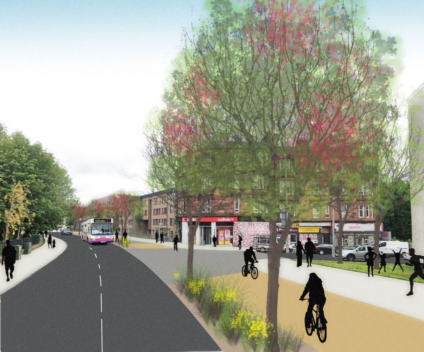
INTRODUCTION
STRATEGIC DEVELOPMENT FRAMEWORKS The Glasgow North SDF sets out a vision and long term links, accessible town centres and planning for economic
strategy that seeks to: development.
The Glasgow City Development Plan Policy CDP 2 -
Sustainable Spatial Strategy identifies six key areas of the City guide the future development of the area to create a Furthermore, there are three City Centre District
which require strategic coordination of development and healthy and high quality place in which to live and Regeneration Frameworks in preparation (Townhead,
investment activity. The six areas have similar issues in terms work; Learning Quarter and, in particular, Cowcaddens), which
of possessing significant areas of vacant land, poor directly interface with the North SDF. These documents will
co-ordinate current activity and direct future actions;
connectivity and uneven open space provision. Each area introduce more detailed guidance in relation to connections
also presents a particular combination of spatial provide principles that will help in the determination between the City Centre and Glasgow North.
opportunities which, if realised, can create a series of of major planning applications and support the
ENGAGEMENT
attractive, connected and healthy neighbourhoods. delivery of key proposals.
Over recent years, a range of engagement exercises have
Throughout the SDF, opportunities are identified which could
increased communities’ influence over spatial proposals and
contribute to wider objectives regarding climate change
In order to coordinate activity, Strategic Development plans affecting their areas (See Appendix B Engagement
mitigation and adaptation. These include making it easier to
Frameworks are being prepared for the following areas: Events 2014-2019, page 47). Whilst these exercises have
live and work locally, active travel and public transport
Glasgow North varied in scale - from a single site to area strategies - they
improvements and green network enhancements, among
have often highlighted communities’ wider aspirations for
City Centre other measures.
environmental improvement. The wider ambitions and
River Clyde Development Corridor The Glasgow North SDF is being progressed through a findings of these recent consultations have helped to inform
process leading to its approval as Supplementary Guidance to the vision, key outcomes and Guides set out in the Glasgow
Govan Partick
the City Development Plan. North SDF.
Inner East
Preparation of the SDF has been informed by a range of GLASGOW NORTH SDF
Greater Easterhouse strategies and initiatives, a selection of which are listed in
The Glasgow North SDF is directed at everyone with an
In broad terms the six areas have been selected because they Appendix A (page 46). More recently, Covid-19 has brought a
number of issues into sharp focus, in particular, where we interest in improving and investing in Glasgow North to help
have a specific mix of physical issues, socio-economic
live, how we work, access to open space, the quality of our create a healthy and high quality place.
indicators and strategic opportunities. The SDFs provide a
long-term vision for the regeneration of the relevant area surroundings, public health and wellbeing. The Glasgow You are asked to comment on the content of the SDF by 5.00
and a sustained commitment beyond the term of the current North SDF is well timed to address many of these issues and p.m. on Thursday 10th December 2020.
to support the social and economic recovery of this area of
City Development Plan. This is set out in more detail in the
the city, through a focus on placemaking, good active travel
relevant background paper to the City Development Plan. Plan, Build, Share: A Healthy, High Quality Place
Glasgow North SDF 4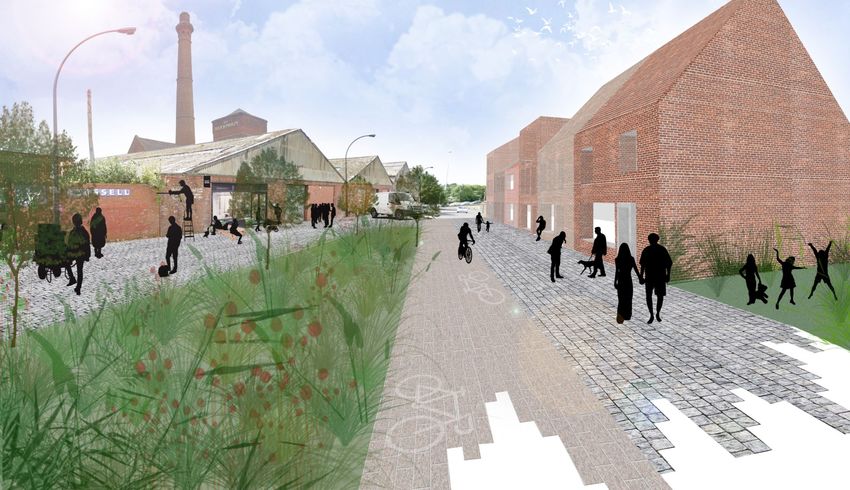
C O N T E X T A N D A R E A P R O F I L E | L O C AT I O N A N D S PAT I A L C O N T E X T

                                                                                        GLASGOW NORTH
                                                                             STRATEGIC DEVELOPMENT FRAMEWORK AREA

                 WEST END

                                                                                            CITY CENTRE

All images in this document are the property of Glasgow City Council and are produced
under © Crown Copyright and database right 2019. OS Licence No. 100023379
Glasgow North SDF                                                                                                   5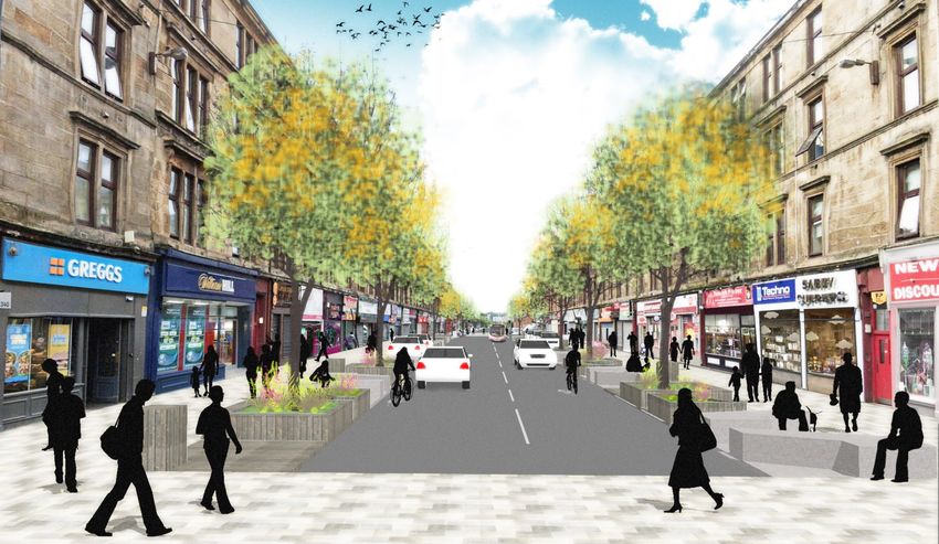
C O N T E X T A N D A R E A P R O F I L E | L O C AT I O N A N D S PAT I A L C O N T E X T

LOCATION                                                         URBAN PAST                                                       having begun on Sighthill Transformational Regeneration
                                                                                                                                  Area (TRA) in the inner north.
Glasgow North encompasses a substantial area of the City,        The North contains several different neighbourhoods each
stretching from the City Centre in the south through to the      with their own individual heritage. Overall, the area was        British Waterways (now Scottish Canals) through the
green belt in the north. In 2018, the area had a resident        historically famous for its industry, most notably in the form   Millennium Link Project worked along with others to make
population of around 67,800 people. Glasgow North also           of the railways works in Springburn and Saracen Foundry in       the Forth and Clyde Canal navigable again, following years of
neighbours the City’s west end, as well as East                  Possilpark. The Forth and Clyde Canal is another defining        decline in condition. The canal is now an important leisure,
Dunbartonshire. There are three main arterial routes             historical feature, having played a central role in the          biodiversity and active travel asset. Significant investment in
(Springburn Road, Balmore Road, Maryhill Road) serving the       formative years of the industrial era. Town centres also         the canal corridor has continued, and in the past decade a
north, which also act as commuter roads into the City.           developed in Maryhill, Possilpark and Springburn, which          variety of cultural and sports organisations have located to
                                                                 remain vital locations to this day.                              the southern end of the area.
There are several large open spaces, particularly moving out
from the City Centre, and the Forth and Clyde Canal runs         During the inter-war and post-war years, municipal house         BUILDING INTO THE FUTURE
through the area, including an individual branch which           building programmes replaced many of the older tenements,
                                                                                                                                  There are currently three important initiatives in the form of
terminates just before the M8. The River Kelvin is also          and broader redevelopment caused significant changes to
                                                                                                                                  Transforming Communities Glasgow (TCG), Glasgow Canal
located immediately to the west, running down to the River       the built form in some places. This has resulted in a
                                                                                                                                  Regeneration Partnership (GCRP) and Glasgow City Region
Clyde, and when combined with the canal can be seen to           dominance of road infrastructure in certain areas, as well as
                                                                                                                                  City Deal, which are working towards the transformation of
form a loop connecting all three waterways back around to        at times a low residential density. There is also a legacy of
                                                                                                                                  specific areas within the north. TCG continue to progress
the City Centre.                                                 housing demolition on some sites which has not yet been
                                                                                                                                  Transformational Regeneration Areas (TRAs) at Sighthill and
                                                                 replaced, and coupled with the urban impact of
Glasgow North contains a series of neighbourhoods with                                                                            Maryhill, GCRP have a focus on the growth of leisure activity
                                                                 deindustrialisation has resulted in problems with fragmented
distinct histories and character. The inner north, in close                                                                       on the canal, and City Deal projects aim to intensify and
                                                                 urban form.
proximity to the City Centre, contains both stable residential                                                                    develop economic activity, particularly in the case of the
communities and a central section going through transition       RECENT YEARS                                                     North Gateway.
and redevelopment. As you move further out, the urban
                                                                 In more recent years, there have been efforts by a variety of    There are also proposals for large scale development projects
form has a mixture of tenemental character, post-war social
                                                                 organisations to improve place quality. Housing associations     at Hamiltonhill, Dundashill, Cowlairs, and the former Ruchill
housing, more recent development and a continuing legacy
                                                                 have played a key role in developing vacant sites as well as     Hospital site, where a managed process of transition is
of vacant and derelict land. The outer north becomes more
                                                                 improving the condition of existing stock. Private housing       required e.g. through a site-specific masterplan.
open in character, with an increase in green space as a result
                                                                 development has also been implemented on particular sites,
of post-war housing neighbourhood design.
                                                                 adding to the mixture of tenure available. Major housing-led
                                                                 developments are planned for the coming years, with work

Glasgow North SDF                                                                                                                                                                                   6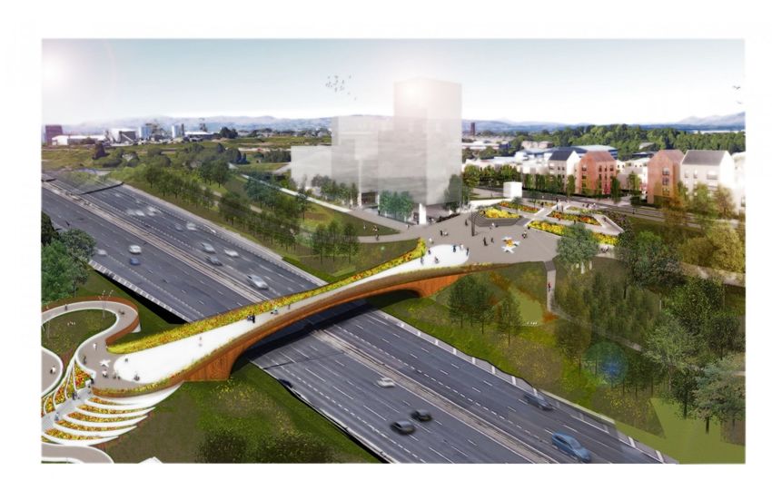
CONTEXT AND AREA PROFILE | COMMON ISSUES
COMMON ISSUES This issue is illustrated spatially on the map contained on This trend has created a perception that centres now have a
page 8. more limited shopping offer, which may suppress footfall,
A number of issues continue to affect Glasgow North and
spend and vibrancy levels. These issues are compounded by a
highlight the need for a long-term strategic approach that co-
perceived lack of public investment towards environmental
ordinates future activities and supports the transition to a
PEDESTRIAN/CYCLIST ENVIRONMENT maintenance and improvement. Local shopping parades have
healthy, high quality place. These include:
On certain stretches of the main arterial routes, vehicle- been similarly affected by a loss of shops and reduced
dominated street layouts inadvertently create a poor environmental quality over the years. There is a need to
VACANT AND DERELICT LAND environment for pedestrians and cyclists: these stretches are address gaps in neighbourhood facility provision as well as to
unpleasant to walk/cycle along and difficult to cross at prepare adequately for future population increases.
Large-scale housing demolitions of the 1980s and 1990s have
points. This includes sections of Maryhill Road, Garscube
left some districts under-populated and affected by vacant
Road and Springburn Road (typically 4 lane sections) and
sites. This not only detracts from the appearance and quality SOCIAL EXCLUSION AND ACCESS TO EMPLOYMENT
Craighall Road (2 lane section). This issue is illustrated
of place, but causes a sense of dislocation. In addition, gap
spatially on the map contained on page 8. The fragmentation of Glasgow North’s urban form during the
sites located along major arterial routes often lack built form
years of deindustrialisation was coupled with the growth of a
and activation at street level. The SDF seeks to stimulate
series of wider social issues. Certain parts of the area contain
developer interest and facilitate the appropriate a particular concentration of factors and are listed on the
ACCESS TO GOOD QUALITY OPEN SPACE AND THE GREEN
development of vacant sites, however, in the short-to- Scottish Index of Multiple Deprivation (SIMD) as amongst the
NETWORK
medium term, environmental improvements and meanwhile most deprived in Scotland.
uses will be encouraged. Housing developments of the 1990s/2000s helped improve
amenity space and parks provision in some localities over the The SDF, as a spatial strategy, cannot directly address the
This issue is illustrated spatially on the map contained on socio-economic root causes, however it can help shape the
same period. However, there remain specific issues within
page 8. The map was compiled using information from the environment in which people live and impact positively on
Glasgow North relating to the green and open space network
Scottish Vacant and Derelict Land Survey 2017: sites shown physical and mental wellbeing by, for example:
which require to be addressed. There remain places in the
on the map are those of a medium-large scale and hence not Increasing access to local services and facilities;
north which do not have good accessibility to publicly
every site from the Survey is included.
useable open space per the standards set out in the Glasgow Promoting equality of access through public transport
Open Space Strategy. and active travel improvements;
BARRIERS TO MOVEMENT Improving access to quality open space and the green
Physical barriers such as the M8 motorway, rail and canal LOCAL FACILITY PROVISION network;
infrastructure reduce pedestrian accessibility in particular
The centres have seen their retail sector gradually reduce Supporting inclusive economic growth and access to
areas and adversely affect connectivity to the City Centre.
over time, balanced by an increase in service and other uses. employment opportunities.
Glasgow North SDF 7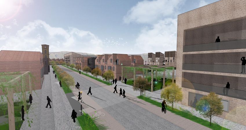
CONTEXT AND AREA PROFILE | COMMON ISSUES
SPATIAL ISSUES
Science Park
Maryhill
Park
Possil Marsh
Summerston Cemetery
Milton
Park
Cadder
Milton
Gilshochill
Lambhill
Ruchill
TRANSPORT
TRANSPORT Golf
Ruchill
Course
Maryhill Golf Course
INFRASTRUCTURE
INFRASTRUCTURE
Main
Mainroad
Road Ruchill
Springburn
Park
Former Hospital
Rail line
Rail Line Site
Ruchill
Ruchill
Rail station
Rail Station Park
Park
Possilpark
Forth and
Forth Clyde
and Canal
Clyde Canal
Springburn
Hamiltonhill
SPATIAL ISSUES
SPATIAL ISSUES
Cowlairs
Vacant or Site
Vacant derelict site Sighthill
Petershill
Cemetery
Park
Barrier to to
Barrier movement
movement
caused by
caused by transport
transport Woodside
Dundashill Sighthill
infrastructure
infrastructure
Glenconner
Park
M8
Poor pedestrian/cyclist
Poor pedestrian
Royston
environment
environment
CITY CENTRE
Glasgow North SDF 8CONTEXT AND AREA PROFILE | PRIORITIES
PRIORITIES
For all the investment to date, into the future the north will Priority 1: Support the positive redevelopment
still possess a legacy of vacant sites, some of which could be of vacant land by stimulating developer interest
considered for meanwhile interventions prior to and co-ordinating delivery, while promoting
redevelopment.
environmental improvements and meanwhile
uses in the short-to-medium term.
The Scottish Government has published a Land Rights and Priority 2: Empower communities to shape the
Responsibilities Statement, which states as a principle that plans and developments affecting their areas.
more local communities should have the opportunity to own,
lease or use buildings and land which can contribute to their
community’s wellbeing and future development. In the
coming years, as development gathers pace across the north
it is vital that communities are empowered to influence and
lead on proposals affecting their areas.
City Development Plan Policy CDP 1 defines placemaking as a
Priority 3: Promote a placemaking approach in
holistic process that takes into account area context and
the design of proposals and interventions, to
balances a range of interests and opportunities in order to
design successful places. Placemaking factors include the
ensure projects achieve good place quality and
need to address climate change by implementing adaptation address the climate change objectives set out in
measures, thereby helping improve local resilience. the Development Plan.
Glasgow North SDF 99VISION AND OUTCOMES
VISION AND OUTCOMES
The Council’s high-level spatial ambitions for Glasgow North are set out below.
Our vision is for Glasgow North to become a healthy and high quality place in which to live and work.
VISION
A WORKING NORTH A LIVEABLE NORTH A CONNECTED NORTH A GREEN NORTH
OUTCOMES
Attractive and accessible Thriving, sustainable neighbourhoods Well-connected neighbourhoods with An accessible and multi-functional
business locations that support that support healthy living. excellent public transport, walking and green network where nature and
enterprise, employment and
cycling links to improve accessibility communities can flourish.
economic inclusion.
and reduce car use.
Glasgow North SDF 10S PAT I A L D E S I G N S T R AT E G Y SPATIAL DESIGN STRATEGY The Spatial Design Strategy outlined across the following pages covers eight spatial topics. These themes set out principles that will guide future development proposals, assist in the determination of major planning applications and help achieve our vision of a healthy and high quality place in which to live and work. Glasgow North SDF 11
S PAT I A L D E S I G N S T R AT E G Y | W O R K I N G N O R T H
CURRENT PLACE CONTEXT students and workers from both the local area and healthy town centres, where economic development
further afield, and could provide a catalyst for contributes to the sense of place in each respective
Glasgow North possesses a series of economic assets,
associated business growth and other activity. area.
including:
Traditional business locations, identified as Economic
Development Areas (EDAs) in the City Development OVERALL OUTCOME CURRENT POLICY CONTEXT
Plan. Many of these locations sustain a level of
Attractive and accessible business locations that support Glasgow City Development Plan (CDP) emphasises several
economic activity and employment., however there
enterprise, employment and economic inclusion. objectives relating to economic activity, including a focus on
are opportunities for investment, place improvement
employment, sustainable business locations, protection of
and, where appropriate, the introduction of a greater
key locations and the requirement that through inclusive
mix of supporting uses. SUPPORTING OUTCOMES economic growth , local communities are rejuvenated. The
West of Scotland Science Park - high profile life The Council’s aspiration is for Glasgow North to: Working North Themes (pages 14-17) seek to drive forward
science and technology businesses, and research the following Development Plan policies:
Provide the right environment for existing business to
institutions set in a high quality environment, with
grow and to attract new businesses and supporting Policy CDP 3 - Economic Development
prospect for intensification and introduction of
uses; Policy CDP 4 - Network of Centres
innovative greening projects.
Enable people to work close to where they live with
Town Centres - centres maintain a mix of shops and
increased local employment opportunities, and
services and have potential to grow their role as first THEMES
improved accessibility via active travel and public
choice ‘shop local’ destinations.
transport, aiding both economic inclusion and climate The rest of this section is split into two Themes, namely:
North Gateway - possesses a mix of traditional change mitigation goals;
Enterprise
industrial, canal leisure and cultural uses: these
Offer improved attractiveness and environmental
sectors could expand and combine to create a truly North Gateway - Specific principles are set out for
quality around business locations;
diverse, creative and vibrant Gateway economy. this area due to the considerable change which is
Support growth in emerging sectors and industries, as anticipated in the near future, and its advantageous
Health and Education Institutions - Stobhill Hospital
well as new ways of working, with a focus on West of location next to the City Centre, higher education
Campus provides a focus for health and related
Scotland Science Park and the North Gateway area; institutions and strategic transport infrastructure.
activity which has the potential to be built upon. The
Springburn Campus of Glasgow Kelvin College draws Have an identity as a vibrant, thriving place with
Glasgow North SDF 12S PAT I A L D E S I G N S T R AT E G Y | W O R K I N G N O R T H Sketch showing how light industry, other workspaces and housing can come together to create a vibrant mixed use area. Glasgow North SDF 13
S PAT I A L D E S I G N S T R AT E G Y | W O R K I N G N O R T H
THEME: ENTERPRISE

WHERE WE ARE NOW                                               to proposals in Use Classes 4 ‘Business’, 5 ‘General Industrial’ developments at appropriate locations, to complement the
Current activity: Economic Development Areas (EDAs) close      or 6 ‘Storage or Distribution’, of the Town and Country           Gateway’s evolving mixed use character. Further principles
to the City Centre and motorway network are fairly             Planning (Use Classes)(Scotland) Order 1997.                      specific to the North Gateway are contained on page 16.
successful in maintaining activity levels and attracting new
occupiers. However some areas contain a higher proportion      PR2 The SDF encourages the preparation of locally-led, EDA        PR5 Small scale industrial and businesses activities can bring
of vacant plots, which adversely affect their overall          improvement plans to create more attractive and                   additional vibrancy to residential areas. The SDF will support
environment.                                                   sustainable environments. Businesses could be supported to        new, small scale business developments which enhance local
                                                               prepare plans that promote opportunities and set out              amenity and provide employment/economic uses within
Opportunities: The SDF advocates taking measures to            landscape and active travel proposals. Such plans could help      walking distance of housing.
improve the attractiveness and place quality of business       attract future investment and encourage appropriate
areas, from environmental improvements (landscaping,           supporting uses, contributing to the function and future          PR6 Town centres play a central role as economic and
enhanced connectivity and active travel) through to            viability of the EDA.                                             employment locations, and the SDF supports the town
encouraging new commercial and supporting uses, in order                                                                         centres first approach where they are the preferred location
to create more sustainable places for workers, visitors and    PR3 The SDF supports West of Scotland Science Park’s role         for retail and other appropriate uses. Appropriate small scale
local residents alike.                                         as a leading research, innovation and technology location         business activities (use class 4) are encouraged where they
                                                               that contributes to the wider City and regional economy. The help support the vibrancy of town centres.
OVERALL OUTCOME                                                SDF encourages further sustainable development of the
                                                               Science Park to help grow this sector and enhance activity. A     PR7 There is potential for supporting uses in and around
Attractive and accessible business locations that support      campus plan approach could help promote the Park as an            Stobhill Hospital Campus which would encourage growth in
enterprise, employment and economic inclusion.                 attractive business location and enhance its landscape value      its existing health function and research activity. There is also
                                                               and active travel accessibility.                                  potential for the development of an educational hub
PRINCIPLES
                                                                                                                                 focussed on Kelvin College in Springburn with associated
In order to work towards the above outcome, the following      PR4 The SDF seeks to balance existing industrial and              business growth and other activity.
principles (PR) are set out:                                   business uses in the North Gateway area with emerging
                                                                                                                                 The diagram on page 15 illustrates how the Enterprise
                                                               opportunities. While the anchor uses represent established
PR1 The SDF recognises that the north’s Economic                                                                                 principles could apply spatially.
                                                               activity and should be retained, it is recognised that the area
Development Areas form a vital part of the City’s economy.     is undergoing considerable change. The SDF encourages the
The SDF supports the retention and improvement of the          introduction of good quality commercial, cultural and leisure
north’s Economic Development Areas with preference given

Glasgow North SDF                                                                                                                                                                               14
S PAT I A L D E S I G N S T R AT E G Y | W O R K I N G N O R T H
ENTERPRISE: PRINCIPLES DIAGRAM EXISTING ASSETS
Main arterial thoroughfare
Existing rail line
Existing rail station
Science Park
River Kelvin Walkway
Summerston
Maryhill Park Canal Towpath
Possil Marsh
Cemetery
PRINCIPLES (PR)
Balmore
Cadder Industrial Milton Prepare Science Park framework
Estate (PR3)
Colston Economic Development Area -
support retention (P1)
Hospital EDA - encourage preparation of
Enterprise improvement plan (PR2)
West Media Park
Business development opportunity
Shuna Street
Chapel Street I.E. Possilpark (PR1)
Industrial Springburn Park
Industrial
Maryhill Estate
Estate
Town Centre
Ruchill Park Glasgow Kelvin College/ Stobhill
River Kelvin Cowlairs
Springburn Hospital - support intensification of
WEST END Town Centre the principal uses at these locations
Possilpark Industrial
Town Centre Estate (PR7)
Atlas I.E. Speirs Locks - support expansion of
University performing/visual arts sectors(PR12)
Oakbank M8 Foodpark
Industrial Industrial
Estate Estate Petershill
Road I.E.
Garscube
Industrial
Estate Charles Street I.E.
M8
Royston
CITY
CityCENTRE
Centre
Glasgow North SDF 15S PAT I A L D E S I G N S T R AT E G Y | W O R K I N G N O R T H
THEME: NORTH GATEWAY
WHERE WE ARE NOW
Current Activity: The North Gateway contains a number of PR8 The SDF seeks to strengthen the Gateway economy by PR12 Speirs Locks Cultural Quarter - The SDF supports
established business areas that anchor the local economy. In supporting: expansion of the performing and visual arts sectors at this
recent years the area’s economy has diversified through the The current function of EDAs and retention of existing location to help create a vibrant destination within walking
creation of the Speirs Locks cultural quarter, canal commercial uses across the Gateway; distance of the city centre.
watersports activities and 100 Borron Street office Introduction of new high quality commercial uses;
development. Growth of the cultural sector for performing and PR13 The Dundashill development is set to establish a new
visual arts; residential area that will greatly enhance the character and
Opportunities: The North Gateway benefits from an Expansion of canal leisure activities; vitality of the Gateway. The SDF supports introduction of
advantageous location next to the City Centre, higher Additional ancillary uses within the area. appropriate supporting service uses to create a sustainable
education institutions and strategic transport infrastructure. community.
The SDF seeks to support uses that will grow the unique mix PR9 The Gateway area is on a journey to becoming a more
of sport, leisure and cultural activity around the canal, as well mixed use area, where business and residential activities lie PR14 Woodside - The SDF supports improvement of local
as sustaining a strong industry and business sector in the in close proximity to each other. The SDF seeks to ensure shopping facilities and the wider economy of Woodside.
wider Gateway. Particular encouragement will be given to existing and new uses co-exist well together, contributing to
innovative, high quality proposals, where these enhance the a good overall place quality. Within the North Gateway, the PR15 The SDF will encourage introduction of supporting
area’s evolving mixed use character and help create an SDF encourages commercial development proposals outside uses and active travel improvements at appropriate locations
attractive destination. Appropriate developments expanding of EDAs which accord with SG3 - Economic Development. across the Gateway.
the area’s cultural and canal leisure sectors will be
welcomed. PR10 The area around Port Dundas and High Craighall Road The diagram on page 17 illustrates how the North Gateway
is ideally positioned just to the north of a concentration of principles could apply spatially.
OVERALL OUTCOME higher education activity in the City Centre. It is therefore
Attractive and accessible business locations that support well placed to provide a next stage location for associated
enterprise, employment and economic inclusion. industry and business.
PRINCIPLES PR11 The SDF supports the development of Pinkston into a
In order to work towards the above outcome, the following canal hub containing an attractive mix of canal leisure, rest
principles (PR) are set out: and refresh facilities.
Glasgow North SDF 16S PAT I A L D E S I G N S T R AT E G Y | W O R K I N G N O R T H
NORTH GATEWAY: PRINCIPLES DIAGRAM
EXISTING ASSETS
Main thoroughfare
Existing rail line
Canal Towpath
EMERGING ASSETS
Large scale housing development
- under construction
M8 Foodpark
Woodside
Speirs
Locks PRINCIPLES (PR)
Economic Development Area -
Dundashill support retention (P1)
EDA - encourage preparation of
improvement plan (PR2)
Speirs Locks - support expansion
of performing/visual arts sectors
(PR12)
City Centre M8
Glasgow North SDF 17S PAT I A L D E S I G N S T R AT E G Y | L I V E A B L E N O R T H
CURRENT PLACE CONTEXT SUPPORTING OUTCOMES Policy CDP 9 - Historic Environment
Glasgow North possesses a number of sustainable The Council’s aspiration is for Glasgow North to:
community assets including: Achieve reduced levels of vacant and derelict land Policy CDP 5 - Resource Management states that the Council
through appropriate redevelopment; will support proposals that contribute to reducing
Established communities with a settled urban form,
greenhouse gas emissions and overall energy use, and which
having capacity for place quality improvements. Provide well integrated neighbourhoods with a
facilitate the delivery of renewable energy and heat. This
sustainable housing mix and good access to open
Neighbourhoods undergoing long-term change, with includes designing new development to reduce energy use.
space and local facilities, thus contributing to climate
potential to achieve improved provision of housing,
change mitigation objectives;
facilities, open spaces and active travel connections.
Support local living through provision of attractive, THEMES
Maryhill, Possilpark and Springburn Town Centres
walkable town centres and neighbourhood focal
provide an accessible mix of shops and services and The rest of this section is split into two Themes, namely:
points;
have potential for growth and place improvement. Neighbourhoods
Foster an enhanced sense of place and local identity.
Royston Road possesses a valuable cluster of shops, Town Centres
public facilities and businesses that have the potential
to grow into an attractive town centre. CURRENT POLICY CONTEXT
A variety of local shopping parades, some of which
Glasgow City Development Plan (CDP) emphasises several
could expand to become neighbourhood focal points.
priorities relating to liveability, including the necessity of
placemaking as a guiding principle and a focus on health
OVERALL OUTCOME impacts, community facilities, residential quality, useable
spaces and heritage. The Liveable North Themes (pages 20-
Thriving, sustainable neighbourhoods that support healthy
24) seek to drive forward the following Development Plan
living.
policies:
Policy CDP 1 - The Placemaking Principle
Policy CDP 4 - Network of Centres
Policy CDP 5 - Resource Management
Glasgow North SDF 18S PAT I A L D E S I G N S T R AT E G Y | L I V E A B L E N O R T H Sketch showing how housing, open spaces, paths and streets can come together to create a well-balanced neighbourhood. Glasgow North SDF 19
S PAT I A L D E S I G N S T R AT E G Y | L I V E A B L E N O R T H
THEME: NEIGHBOURHOODS

WHERE ARE WE NOW                                                   OVERALL OUTCOME                                                 and the retrofitting of these aspects into the existing built
Current Activity: The Council is working with local partners,
                                                                   Thriving, sustainable neighbourhoods that support healthy       environment. These elements will contribute to both climate
including City Deal and Glasgow Housing Association, to            living.                                                         change mitigation and adaptation.
progress significant regeneration projects at Sighthill and
Maryhill. The Sighthill Transformational Regeneration Area is      PRINCIPLES
                                                                   In order to work towards the above outcome, the following       PR19 The SDF supports new joint-working initiatives to
a major housing-led project that includes new schools, sports
                                                                   principles (PR) are set out:                                    introduce meanwhile uses to large vacant sites, particularly
facilities and a range of housing tenures. A new pedestrian
                                                                                                                                   to key frontages. Temporary projects could animate
and cycle bridge over the M8 motorway will enhance
                                                                   PR16 The City Development Plan sets out a strategic             prominent sections within sites (e.g. adjacent to houses,
integration with the city centre. Additionally, major new
                                                                   outcome for neighbourhoods to become thriving and               schools and pedestrian routes), enhancing local identity,
housing is proposed for Dundashill, Hamiltonhill, Cowlairs
                                                                   sustainable places, providing a choice of good quality mixed    wellbeing, development potential and community
and the former Ruchill hospital site. These developments can
                                                                   tenure housing. In the north, these goals will be achieved in   participation levels.
help contribute to the renewal of existing neighbourhoods
                                                                   part through the delivery of large-scale mixed tenure
and encourage further investment across the wider North.
                                                                   housing developments at Sighthill TRA, Maryhill TRA,            PR20 The SDF supports measures to protect, preserve and
                                                                   Dundashill, Cowlairs and Hamiltonhill. Additionally, delivery   enhance the historic environment. This includes listed
Opportunities: The SDF seeks to create sustainable
                                                                   of development opportunities throughout the area will help      buildings, but also extends to the wider historic built form,
neighbourhoods where people choose to live, work and
                                                                   to achieve better functioning of existing neighbourhoods.       such as along the main arterial routes and the canal. Local
spend leisure time. It promotes a placemaking approach to
                                                                                                                                   heritage should be used to foster place identity and quality,
the design of new developments and supports the balanced
                                                                   PR17 The SDF promotes a placemaking approach and                and should be promoted in design proposals.
delivery of the north’s regeneration projects, wherein each
                                                                   encourages developers to ensure that each delivery stage of
phase ensures new housing is coupled with quality open
                                                                   a major housing scheme provides a balance of new dwellings, PR21 The SDF supports street-facing redevelopment of gap
space and active travel links. Glasgow’s Housing Strategy
                                                                   open space and active travel links. In housing developments sites, including ground floor activation where appropriate, to
presents a vision that aligns with this approach. It states that
                                                                   of all scales, securing rounded development should be an        increase neighbourhood vibrancy. In particular, the
new housing ‘should be situated in attractive, well managed
                                                                   essential target, so that new and existing residents can        improvement of built form and open space along the main
neighbourhoods’ with ‘convenient access to work, education,
                                                                   benefit from good access to outdoor spaces and active travel arterial routes should complement the Avenues North
shopping, leisure and cultural activities’.
                                                                   links.                                                       project. Please refer to Appendix D for an illustration of the
                                                                                                                                   streetscene activation opportunities.
The SDF also recognises the need to re-energise the north’s
                                                                   PR18 The SDF supports new development being energy
main arterial streets through introduction of meanwhile uses                                                                       The diagram on page 21 illustrates how the Neighbourhoods
                                                                   efficient and incorporating integrated green infrastructure,
and sensitive redevelopment of gap sites.                                                                                          principles could apply spatially.

Glasgow North SDF                                                                                                                                                                                  20
S PAT I A L D E S I G N S T R AT E G Y | L I V E A B L E N O R T H
NEIGHBOURHOODS: PRINCIPLES DIAGRAM
Maryhill
Park Summerston
Possil
Cemetery
Marsh
Cadder
Milton
Gilshochill
Hospital
Maryhill
Locks
Maryhill Springburn
Park
Town Centre PRINCIPLES (PR)
EXISTING ASSETS
Ruchill Support large scale housing
Main arterial thoroughfare Former Hospital
River Kelvin Park Site development (PR16)
Springburn
Existing rail line Possilpark
Town Centre
Town Centre
Existing rail station
Support small scale housing
River Kelvin Walkway College development (PR16)
Hamiltonhill
Canal Towpath Sighthill
Cemetery
Cowlairs
Woodside
EMERGING ASSETS Dundashill
Large scale housing development Glenconner
- under construction or with Sighthill Park
M8
planning permission
Royston
Small scale housing development
- under construction or with
CITY CENTRE
M8
planning permission
M8
Glasgow North SDF 21S PAT I A L D E S I G N S T R AT E G Y | L I V E A B L E N O R T H
THEME: TOWN CENTRES
WHERE WE ARE NOW PRINCIPLES enhancement of the existing local shopping facilities to the
Current activity: The North’s town centres continue to In order to work towards the above outcome, the following south of Maryhill Station, with the potential to be considered
generate moderate investment and spend levels, in the face principles (PR) are set out: as an addition to Maryhill Local Town Centre.
of low catchment populations and move towards out-of-
PR25 The SDF will support proposals to enhance local
centre shopping: commercially, centres appear to be getting PR22 The City Development Plan supports the town centres
shopping parades through investment in shops and public
by rather than thriving. Environmental factors such as poor first approach where centres are the preferred location for
realm improvements. Such enhancements could contribute
streetscene/spaces/pedestrian links contribute to centres’ retail and other appropriate footfall generating uses, coupled
to more local living patterns and reduce reliance on car
weak physical identity. with a strong residential component. The Plan also
usage. The SDF supports efforts to provide local shopping
recognises the value of local shopping parades as on-the-
facilities as part of the Sighthill TRA.
Opportunities: The SDF supports initiatives to ensure local doorstep local facilities. In North Glasgow, investment should
town centres are attractive, vibrant places that provide retail, be targeted towards improving centres’ environment,
PR26 In Cadder, Lambhill and Milton the local shopping
services and a range of other uses. Through targeted facilities and accessibility in order to create successful places.
parades provide a vital function within these outer urban
investment programmes such as Town Centre Action Plans,
neighbourhoods. The SDF seeks to protect the current retail
centres can re-establish themselves as diverse community PR23 The SDF supports strengthening Maryhill, Possilpark
function of these locations, whilst encouraging the
anchors within walking distance of residential areas. This, in and Springburn Town Centres via suitable initiatives such as
turn, will help support walking and cycling and minimise the introduction of community and service uses. In other
Town Centre Action Plans. Local groups and shopowners,
need for vehicular transport. neighbourhoods within the north, there could be potential to
with agency and Council support, could be encouraged to
create new centres/focal points where appropriate.
Similarly, the SDF advocates focusing resources towards local deliver shopfront, public realm and lighting improvements to
shopping parades, looking at the potential to upgrade build a centre’s image as a place. Proposals for ongoing PR27 St Rollox and Summerston retail parks provide
shopfronts, co-locate community uses and improve maintenance and management should be included. The shopping facilities in out-of-centre locations. The SDF
environmental quality to enhance vitality. Where conceptual images on page 23 aim to show that if supports continuation of retail parks’ shopping and leisure
opportunities arise for new housing adjacent to a town improvements can build over time, town centres could offer, coupled with active travel and environmental
centre, the SDF encourages higher densities in order to boost become attractive, busy, pedestrian-friendly places. improvements. Measures which make these facilities more
the centre’s footfall and increase vibrancy. attractive and more accessible for pedestrians and cyclists
PR24 Royston Road contains a cluster of local shopping, can contribute to a reduced reliance on car usage. In
OVERALL OUTCOME community and education facilities that serve Royston. The Summerston, the SDF supports improvements to the
Thriving, sustainable neighbourhoods that support healthy SDF supports development of improved services, public community offer in terms of diversified facilities and services.
living. spaces and connections to transform Royston Road into an The diagram on page 24 illustrates how the Town Centres
attractive Local Town Centre. Similarly, the SDF supports principles could apply spatially.
Glasgow North SDF 22S PAT I A L D E S I G N S T R AT E G Y | L I V E A B L E N O R T H
PRINCIPLES PR23 AND PR24: PROMOTING TOWN CENTRE IMPROVEMENT
Maryhill Town Centre illustrative sketch Springburn Town Centre illustrative sketch
Possilpark Town Centre illustrative sketch Royston Town Centre (potential) illustrative sketch
The sketches on this page show examples of the types of public realm improvements that could be delivered within town centres.
Glasgow North SDF These sketches can be viewed as full page images in Appendix E (pages 72-75). 23S PAT I A L D E S I G N S T R AT E G Y | L I V E A B L E N O R T H
TOWN CENTRES: PRINCIPLES DIAGRAM
Maryhill
Park Summerston
Cemetery Possil
Marsh
Cadder
Milton
Hospital
Springburn
Maryhill
Park
Town Centre PRINCIPLES (PR)
EXISTING ASSETS
Ruchill
Main arterial thoroughfare
Park
River Kelvin
Existing rail line Possilpark Local town centre - support
Springburn
Town Centre strengthening of functions and
Existing rail station Town Centre
public realm improvements (PR23)
River Kelvin Walkway
College
Canal Towpath Sighthill
Cemetery
Achieve Local Town Centre status
Public Leisure Centre and support improvement (PR24)
Woodside
Provide new local shopping
Glenconner
facilities at Sighthill (PR25)
Sighthill Park
M8
Royston Retail Park - support active travel/
CITY CENTRE environmental improvements
M8 (PR27)
M8
Glasgow North SDF 24S PAT I A L D E S I G N S T R AT E G Y | C O N N E C T E D N O R T H
CURRENT PLACE CONTEXT SUPPORTING OUTCOMES
The North currently possesses a number of transportation The Council’s aspiration is for Glasgow North to: Policy CDP 11 - Sustainable Transport
and active travel assets including:
Offer good access to active travel and public transport As a requirement of the Land Reform (Scotland) Act 2003,
Two railway lines serving central and outer urban links for residents across the north, contributing to Glasgow has set up a Core Paths Plan which outlines key
districts in particular, with potential to grow as key social inclusion, improved health, environmental access routes. It is a requirement that such routes are
spines within the north’s public transport network; quality and climate change mitigation objectives; protected and developed in Glasgow North.
High frequency arterial bus services catering for inner Provide a series of high quality active travel routes Connectivity Plan and Liveable Neighbourhoods Plan
and central urban communities, holding prospects for and key streets which better connect people with
The Council aims to carry out a “Connecting Communities”
expanding their reach to meet the additional local town centres, places of work, neighbourhood
consultation exercise, in order to inform the preparation of
demands generated by the major new developments; facilities, the wider City and beyond;
transport strategies/plans, including a Connectivity Plan and
The River Kelvin Walkway and Canal towpath serve as Secure improved public transport linkages as a result Liveable Neighbourhoods Plan.
strategically-important active travel corridors: of the Connectivity Plan for Glasgow, in terms of bus The Connectivity Plan for Glasgow will set out a strategic
targeted improvements over time could enhance provision and/or expanded fixed infrastructure; approach and actions to assist the movement of people and
these routes as highly attractive, high amenity goods into and around the City. The Liveable
Move towards a reduced demand for car usage as a
walking and cycling routes. Neighbourhoods Plan (LNP) will seek to reduce the city’s
result of a more integrated and pleasant active travel
and public transport networks, contributing to lower dependency on cars and facilitate walking, cycling and public
transport through physical interventions and behavioural
emissions.
OVERALL OUTCOME change measures. The LNP will follow a place-based
Well-connected neighbourhoods with excellent public approach in the design and delivery of improvements for
transport, walking and cycling links to improve accessibility CURRENT POLICY CONTEXT walking and cycling, integrated green infrastructure and
and reduce car use. public spaces.
Glasgow City Development Plan (CDP) emphasises several
elements relating to connectivity including public transport
provision and wider infrastructure, sustainability, friendly THEMES
streets and repaired active travel links. The Connected The rest of this section is split into two Themes, namely:
North Themes (pages 27-31) seek to drive forward the
Public Transport
following Development Plan policy:
Active Travel
Glasgow North SDF 25S PAT I A L D E S I G N S T R AT E G Y | C O N N E C T E D N O R T H
Sighthill Bridge (consented) - sketch showing the design for a proposed new pedestrian and cycle bridge over the M8 motorway,
which will enhance connections between the City Centre and Sighthill.
Glasgow North SDF 26S PAT I A L D E S I G N S T R AT E G Y | C O N N E C T E D N O R T H
THEME: PUBLIC TRANSPORT
WHERE WE ARE NOW OVERALL OUTCOME Springburn Town Centres;
Current activity: The North is served by a number of high Well-connected neighbourhoods with excellent public New bus-based hubs within other town centres,
frequency bus routes that connect the inner and outer transport, walking and cycling links to improve accessibility
neighbourhood centres and retail parks;
neighbourhoods to the City Centre. The Anniesland/Maryhill and reduce car use.
These hubs could also contain facilities to support
to Queen St High level and Springburn to Queen Street Low
Level rail links connect the north to other rail services and active travel modes.
PRINCIPLES
the City’s subway. However, parts of the north with low
In order to work towards the above outcome, the following
population bases have poor access to bus services, which PR31 The Council will encourage transport providers to
principles (PR) are set out:
may adversely affect residents’ mobility levels.
sustain appropriate bus service provision for Stobhill
PR28 CDP 11 - The City Development Plan aims to ensure Hospital, Glasgow Kelvin College and secondary schools
Opportunities: The SDF advocates increased joint-working
that Glasgow is a connected City, characterised by
between the Council, transport providers, developers and within the north.
sustainable public transport connectivity.
communities to:
As a priority, secure staged improvements to public PR32 The SDF supports interventions to improve the
In Glasgow North, the SDF seeks to support proposals that
transport serving housing-led development areas in walking and cycling links to railway stations in the north.
will help create well-connected neighbourhoods and
the north;
enhanced links with the rest of the city.
In other parts of the north with inadequate public PR33 The SDF supports the exploration of the potential for
transport services, developer contributions should be
PR29 The Council will direct major development to locations expansion of fixed public transport infrastructure, as part of
sought to put in place improved transport provision;
well served by existing public transport services and active the preparation of the new Connectivity Plan.
Examine the potential to introduce high quality bus/
travel routes, or will seek contributions for the provision or
train interchange facilities and bus-based hubs;
enhancement of such services/routes on sites where this is
Assess the potential to improve bus links serving The diagram on page 28 illustrates how the Public Transport
not the case. More broadly, the Council will work with
major hospital and education facilities in the north principles could apply spatially.
partners to enhance public transport connectivity across the
Ensure key transport nodes are situated near points of
north, in line with the emerging Connectivity Plan.
interest, are overlooked and provide local facilities
and shelter;
PR30 At key locations the Council should work with
Work with the emerging Connectivity Plan to deliver
transport providers and communities to establish:
key public transport improvements.
New bus and train interchange hubs at Maryhill and
Glasgow North SDF 27S PAT I A L D E S I G N S T R AT E G Y | C O N N E C T E D N O R T H
PUBLIC TRANSPORT: PRINCIPLES DIAGRAM
Maryhill Park Summerston
Cemetery Possil Marsh
Summerston
Maryhill Gilshochill Cadder
Milton
Local shops/services -
potential addition to
Maryhill Town Centre
EXISTING ASSETS Hospital
Possilpark and
Parkhouse
Public transport accessibility -
Ashfield
high accessibility during peak period
(e.g. buses 12+ per hour) Springburn Park
Maryhill Town
Centre
Existing rail line
Ruchill
Existing rail station Park
Possilpark Town
River Kelvin
River Kelvin Walkway Centre Springburn
Town
Canal Towpath
Springburn
College
PRINCIPLES (PR)
Sighthill
Cemetery Barnhill
Support delivery of a new bus/rail interchange
Woodside
hub (Maryhill TC and Springburn TC) (PR30)
Support delivery of a new bus-based hub
(Possilpark TC and Royston) (PR30)
Support Avenue North Project active travel
M8
improvements (PR37)
Local shops/services -
Improve active travel links around station potential to expand into a
(PR32) CITY CENTRE Town Centre for Royston
M8
City Centre
Glasgow North SDF 28S PAT I A L D E S I G N S T R AT E G Y | C O N N E C T E D N O R T H
THEME: ACTIVE TRAVEL
WHERE WE ARE NOW Upgrade or create new active travel crossings across PR36 The Council will work with agencies and communities
Current Activity: The Council maintains an extensive the road, rail and canal infrastructure to overcome to identify projects that will enhance or provide new active
network of streets and paths that connect communities movement barriers; travel links to cross the M8, main roads, rail and canal
across the north. Within the network, Maryhill Road/ Support implementation of the Connecting Woodside infrastructure in order to overcome accessibility gaps. This
Garscube Road, Balmore Road/Saracen Street and Castle Project and development of the North City Way; includes exploration of the feasibility of new pedestrian
Street/Springburn Road/Springburn Way continue as major Develop the north’s main arterial thoroughfares into bridges and underpass improvements.
active travel routes linking neighbourhoods and town high quality avenues which encourage active travel.
centres. However, in some localities pedestrian accessibility PR37 The Council will seek to work with agencies and
is constrained by a barrier effect caused by stretches of the OVERALL OUTCOME communities to deliver the Avenues North Project and
M8 motorway, rail or canal infrastructure. Well-connected neighbourhoods with excellent public transform the main arterial corridors into high quality routes
transport, walking and cycling links to improve accessibility for active travel and vehicular use. Appendix D (pages 65-71)
Opportunities: The SDF promotes better pedestrian and and reduce car use. provides more detail on the Avenues North concept. In
cycle connectivity between neighbourhoods and to the city addition, a supporting network of key streets will be
centre though continued joint working between the Council, PRINCIPLES promoted.
agencies and communities. It seeks to: In order to work towards the above outcome, the following
Work with the Liveable Neighbourhoods Plan to principles (PR) are set out: PR38 The SDF seeks to support the development and
create walkable, cycle-friendly communities through a delivery of the Liveable Neighbourhoods Plan and other
place-based approach; PR34 CDP 11 In line with policy, the Council will seek to active travel projects. This could also include better
Support the proposed Sighthill Bridge to enhance links ensure that Glasgow North provides high quality walking and utilisation of the green network for active travel and
with the City Centre; cycling facilities to increase active travel levels across improved connections out of the City.
Maximise the potential of the proposed Stockingfield neighbourhoods, business areas and town centres.
Bridge as part of a wider enhancement initiative; PR39 The potential for retrofit flood risk management
Achieve phased improvements to active travel routes PR35 In large scale development areas, walking and cycling interventions should be considered in the design of new
within regeneration areas, including early actions to infrastructure should be provided in each completed active travel infrastructure, where feasible and in appropriate
improve routes to existing schools/shops; development phase to ensure it is well-connected. In locations.
Introduce pedestrian-friendly improvements to the standalone sites, developers should provide good active
southern sections of Garscube Road, Craighall Road travel links within and through new-build schemes. The diagram on page 31 illustrates how the Active Travel
and Springburn Road; principles could apply spatially.
Glasgow North SDF 29S PAT I A L D E S I G N S T R AT E G Y | C O N N E C T E D N O R T H
PRINCIPLE PR37: THE AVENUES NORTH PROJECT - PROMOTING DELIVERY OF HIGH QUALITY ROUTES FOR ACTIVE TRAVEL AND VEHICULAR USE
Maryhill Road illustrative sketch
Balmore Road illustrative sketch
The images on this page show examples of the types of active travel improvements that could be delivered
within Maryhill Road, Balmore Road and Springburn Road, as part of the Avenues North Project. These
sketches can be viewed as full page images within Appendix D.
Glasgow North SDF 30
Springburn Road illustrative sketchS PAT I A L D E S I G N S T R AT E G Y | C O N N E C T E D N O R T H
ACTIVE TRAVEL: PRINCIPLES DIAGRAM
Maryhill
Park
Summerston Possil Marsh
Cemetery
Milton
Park
Local shops/ services - Cadder Milton
potential addition to
Maryhill Town Centre
Colston
EXISTING ASSETS Hospital
Rail line
Springburn
Rail station Eastfield
Park
Maryhill Town Park
River Kelvin Walkway
Centre
Canal Towpath Ruchill Former Hospital
Park Site
River Kelvin
PRINCIPLES (PR)
Claypits
Support Avenue North Project active travel
improvements (PR37) Hamiltonhill College
Cowlairs
Support Key Street public realm improvements Sighthill
(PR37) Cemetery
Woodside
Dundashill
Provide new pedestrian bridge (consented) (PR36)
Local shops/ services -
Glenconner
Explore feasibility for new pedestrian bridge potential to expand into a Park
Sighthill Town Centre for Royston
(PR36) M8
Explore feasibility of street underpass Royston
improvements (PR36)
CITY CENTRE
M8
Strengthen existing or create new green corridor City Centre
(for nature and, where appropriate, active travel
use) (PR42)
Glasgow North SDF 31You can also read