Paulding County, Georgia - Land Use Plan 2017 Comprehensive Plan
←
→
Page content transcription
If your browser does not render page correctly, please read the page content below
Paulding County, Georgia
          Land Use Plan
     2017 Comprehensive Plan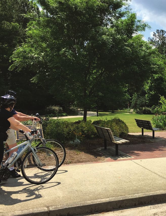
Paulding County, Georgia
                 Land Use Plan

                     PREPARED BY:

     Our mission is to protect and conserve Georgia’s
   natural resources through advocacy, engagement and
                       collaboration.

                     MARCH 2017

    THIS REPORT WAS CREATED IN PARTNERSHIP WITH

                 The College of Design
             Georgia Institute of Technology
           245 4th St. NW | Atlanta, GA 30332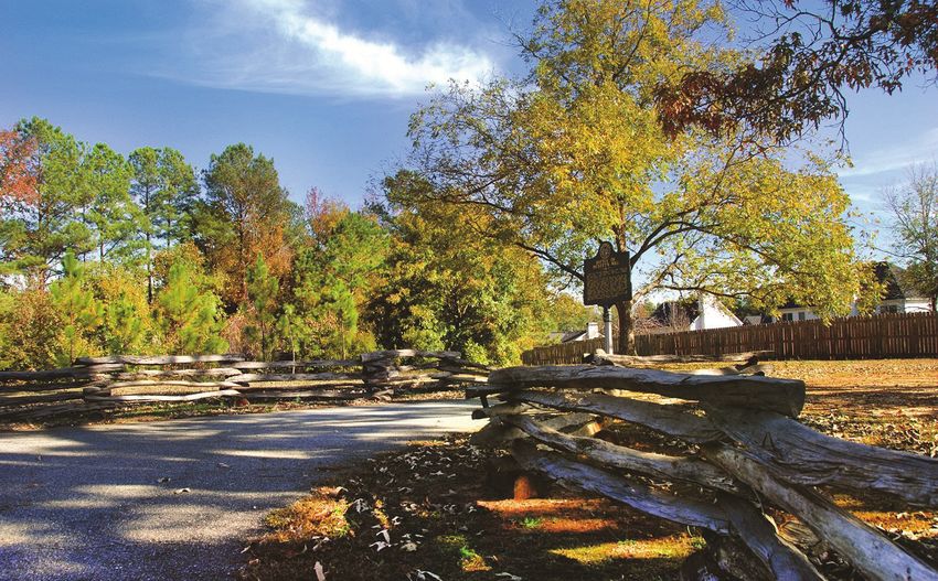
Georgia conservancy
Sustainable growth
 In its 22 years, the Sustainable Growth program has conducted over 37 community-based
 planning projects in neighborhoods, communities, cities and counties focusing on issues
 surrounding natural resource protection, green space accessibility, sustainable land use,
 and live-work connectivity. Typically, this process is done in coordination with an academic
 partner; in this case, Georgia Institute of Technology’s College of Design was engaged in the
 planning process. This process is one of the most highly respected planning processes in
 our state because of its inclusiveness, transparency and technical quality.

CONTENTS
    INTRODUCTION						 7

    ANALYSIS							11

    FUTURE DEVELOPMENT + CHARACTER AREAS		                21

    FUTURE DEVELOPMENT MAP				45

    RECOMMENDATIONS						47

Acknowledgments
COORDINATORS / CONSULTANT TEAM
Jonathan Franklin, Georgia Institute of Technology
Richard Dagenhart, Georgia Institute of Technology
Katherine Moore, AICP, Georgia Conservancy
Johanna McCrehan, AICP, Georgia Conservancy

PAULDING COUNTY MULTI-JURISDICTIONAL WORKGROUP
Ann Lippmann, AICP, Paulding County
Chris Robinson, Paulding County
Kendall Smith, City of Dallas
Michael Cash, City of Dallas
Jody Palmer, City of Hiram
Richard Fennell, City of Braswell
Brian Otott, Board of Education
Ken Elsberry, Board of Education
Robert Reynolds, Paulding County Economic Development
Jody Martin, Paulding County
Mark Long, Paulding County
Julianne Meadows, Northwest Georgia Regional Commission
Ethan Calhoun, Northwest Georgia Regional Commission
Brice Wood, Northwest Georgia Regional Commission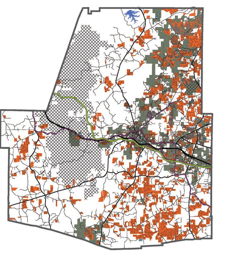
6 Paulding County Land Use Plan
INTRODUCTION

Pressures on Paulding County’s natural resources, communities,
infrastructure and quality of life are continual as the county’s
population continues growing, markets and lifestyles naturally
evolve, and infrastructure ages daily. Planning for Paulding
County’s future is not only required through the Georgia
Department of Community Affairs but is also a pragmatic
exercise in good governance, as the county looks to maintain its
assets, competitiveness as an affordable community, and quality
character as one the Metro Atlanta area’s green counties.

Planning for a county’s future necessitates an initial step of
evaluating current conditions and then considering the future
pressures anticipated by best data on population growth,
economic development, and water impacts, among other factors.
By understanding the fundamental position of the county in
providing basic services to its current residents, it can then be
better understood how population change impacts those service
demands. Layered onto these considerations are responsibilities
of maintaining aspects of the county which are valued by current
residents and will be in demand by future residents. A way
forward in managing resources, both natural and man-made, to
accommodate change while investing in treasured community
characteristics becomes evident.

This land use study, while complex in its detail and scope,
followed a simple, logical process of identifying natural and
man-made features, understanding why the county has developed
in the manner that it has, and then considering how county
leadership might best address future development and economic
demands with an eye towards good natural resource stewardship.
Good natural resource stewardship is both a pragmatic, cost-
conscious consideration—access to quality drinking water can
become a cost burden of immense proportion and an economic
development killer, for example—but is also a leadership
commitment the county has clearly established through its role in
preserving the Sheffield and Paulding Forest Wildlife Management
Areas, among other investments in quality of life assets.

                                                        Introduction   7
Thus, this land use study relied heavily on GIS to identify and map current conditions, with a base map
    of the county’s watersheds. It was critical to not only understand current conditions in order to evaluate
    accommodation of future change, but to also understand where current conditions existed within a
    drainage basin context. Development of land and provision of services via infrastructure are heavily
    influenced by the contour of the land. Wastewater and drinking water systems optimize downslope
    flow; land development is less expensive on flat land; and central travel corridors often follow ridge
    lines. Arguably, the most significant challenge for Paulding County’s future—not unlike state and global
    challenges—is the management of water. As previously stated, access to drinking water will be a limiting
    factor on the county’s growth while obligations to manage wastewater and stormwater can easily become
    crippling government costs, passed along to businesses, residents, and tourists therefore making the
    county an expensive place to live and conduct business.

    The methodology undertaken to perform this land use study is discussed in greater detail in the following
    Analysis section. However, it is important to note that the process involved consideration of existing
    natural and built environment/infrastructure conditions; involved the review of previous, relevant plans
    and studies; and included interviews with representatives of authorities and entities having various
    responsibilities related to Paulding County’s natural and built environment, environmental compliance,
    and service provision to the county’s citizens and businesses. This approach was undertaken in order
    to identify common goals and opportunities, to arrive at multi-benefit investments of time and effort
    through land use recommendations, and to uncover any conflicts among the previous plans and
    responsibilities in order to address those conflicts within the land use plan. The study team found
    common goals and critical leverage opportunities among the various plans and relevant authorities,
    adding further merit and importance to the recommendations documented in this report.

8     Paulding County Land Use Plan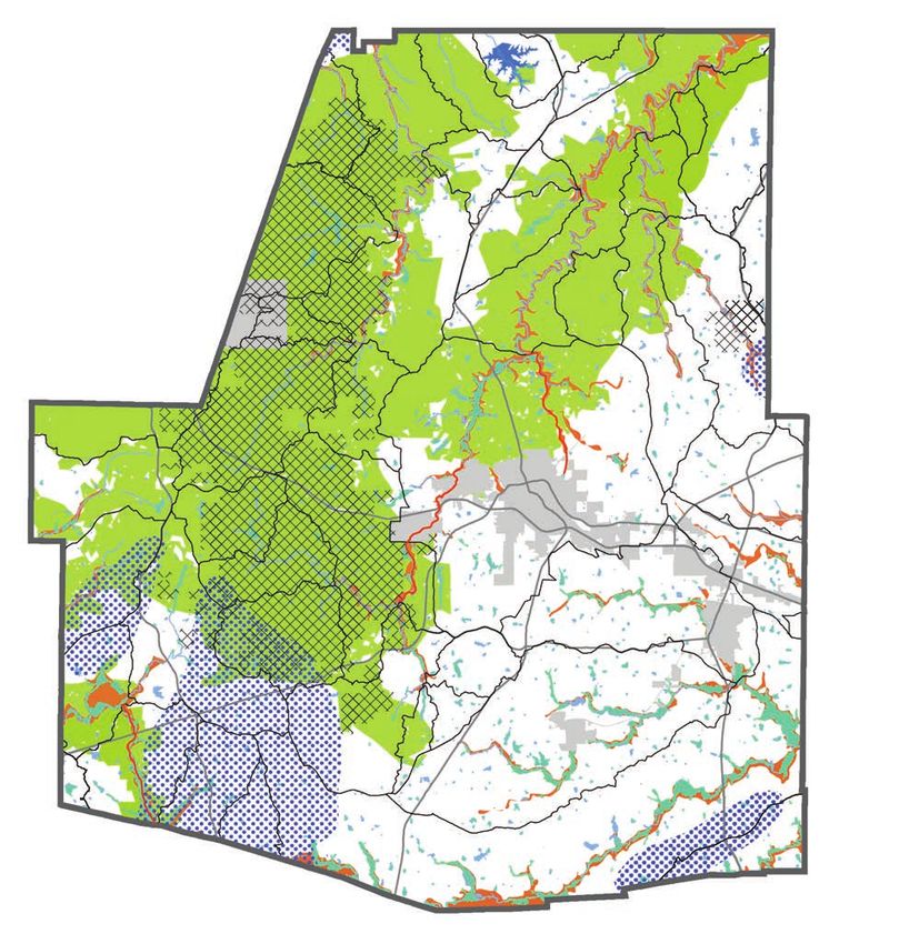
This land use study revealed the value in continuing to direct future growth in areas already supplied
with water and wastewater services, while encouraging future development to be impact-conscious in
its footprint and connections. In prioritizing new development on vacant lots already served by water
and sewer and prioritizing redevelopment in both established residential and commercial centers, both
county government and future residents benefit from cost savings while natural resource impacts are
minimized. This study also uncovered the challenges in development patterns that would worsen traffic
and erode natural amenities highly valued among residents. As a result, the recommendations contained
in this report reflect strategies which leverage existing infrastructure and established neighborhoods
while accommodating growth in more natural or rural expanses through moderation and character-
sensitive approaches.

This Land Use Plan supports the Community Goals identified:
 1. PROTECT AND PRESERVE NATURAL RESOURCES
 2. TARGET GROWTH
 3. LEVERAGE AND PROMOTE EXISTING AND NEW ASSETS
 4. CREATE CONNECTIONS
 5. MAINTAIN FISCAL VIABILITY

                                                                                             Introduction   9
10 Paulding County Land Use Plan
Analysis

Paulding County is at a critical point in deciding its future –
growth is inevitable, but the county has also retained natural and
rural character elements that are recognized as invaluable. New
growth cannot occur at the expense of the natural environment,
and in truth, these elements can coexist through thoughtful
planning.

To understand the conditions currently existing in the county
and to work toward its future vision, the land use team studied
both the existing environmental and infrastructure elements. This
analysis informed the plan on where growth and development
should occur, areas that need special consideration, and where
new growth is not appropriate.

First, we must understand the facts of the land – where has
infrastructure been provided by the county for growth expansion
and investment; where are key assets to the county; and what
areas could be capitalized on for future growth? The predicted
growth is far above the current capacity the county can provide
water service. This challenge can begin to be addressed through
this land use plan. By clearly understanding from an ecological
and investment perspective where growth can and should occur,
we establish a future land use plan. Only then can future projects
around economic development and transportation plans can be
identified.

                                                           Analysis   11
LAND AND WATER ECOLOGY
Water effects everyone by aspects of both quality and quantity. This land use study utilized the framework of
the larger watersheds within Paulding County, and the smaller sub-drainage basins within the county.
Watershed boundaries tend to be designated by topography and ridge lines, meaning that the water which
falls in a specific area will stay within that defined area. Development patterns within these areas affect
the water quality, adding to impervious surface area and causing water to run more quickly off surfaces and
into creeks and rivers. This can cause erosion, sediment issues, and pollution. Paulding has experienced
significant flooding issues in the past and continued growth could intensify these events into the future.
Understanding how to live and work with water is critical to understanding how to manage the land.
There are 46 sub-drainage basins in Paulding County that feed the larger watershed and are impacted by
human development.
Paulding County is included in the Metro
North Georgia Water Planning District
(Metro Water District) and required to
adhere to the District’s plans and policies.
The District was created by the Georgia
General Assembly in 2001 as a planning
agency focusing on regional water resources.
Analyzing current land use conditions and
potential future land use impacts through
the perspective of drainage basins and
watersheds, the land use team ensures that
Paulding County is meeting its management
responsibilities towards water supply and
conservation, wastewater and stormwater.
MAP 1.1
12 Paulding County Land Use PlanWatersheds and drainage basins
COOSA
TALLAPOOSA
CHATTAHOOCHEE
MAP 1.2
Analysis 13Environmental analysis
MAP 2.1 MAP 2.2 MAP 2.3
HYDROLOGY & WETLANDS IMPAIRED STREAMS GROUNDWATER RECHARGE AREAS
This highlights the County’s There are three impaired Groundwater recharge areas are
water features and low lying streams listed on the Georgia important for replenishing the
land areas. Environmental Protection aquifer.
Division website; these
impairments are due to water
quality issues related to runoff.
The ecological components of the county are more permanent components, unchanging without human
intervention. Over 40 years ago the county entered into agreements with the State of Georgia Department
of Natural Resources (DNR) to manage wildlife on a certain property in the county, and then leased an
additional 15,000 acres to create a 25,000 acre Wildlife Management Area (WMA). These protections,
14 Paulding County Land Use PlanMAP 2.4 MAP 2.5 MAP 2.6
FEMA FLOODPLAINS SEF’S PRIORITY ECOLOGICAL AREAS SLOPE ANALYSIS
The national designation of The Southeastern Ecological Darker red and yellow areas
floodplains highlights areas Framework (SEF) determined by show where future development
which are inappropriate for or the Environmental Protection would be difficult because of
difficult to build on because of Agency signals these areas significant slopes.
susceptibility to flooding. of significant importance for
maintaining ecological diversity.
while not permanent, have significantly limited development on the western portion of the county, and
should remain an ecological boundary. The impact of these WMAs combined with limited infrastructure,
have protected Paulding County from rapid growth to this point and should remain an important contributor
to the character of the county.
Analysis 15Infrastructure analysis
MAP 2.7 MAP 2.8 MAP 2.9
ROAD NETWORK PARKS AND GREENSPACE FIBER NETWORK
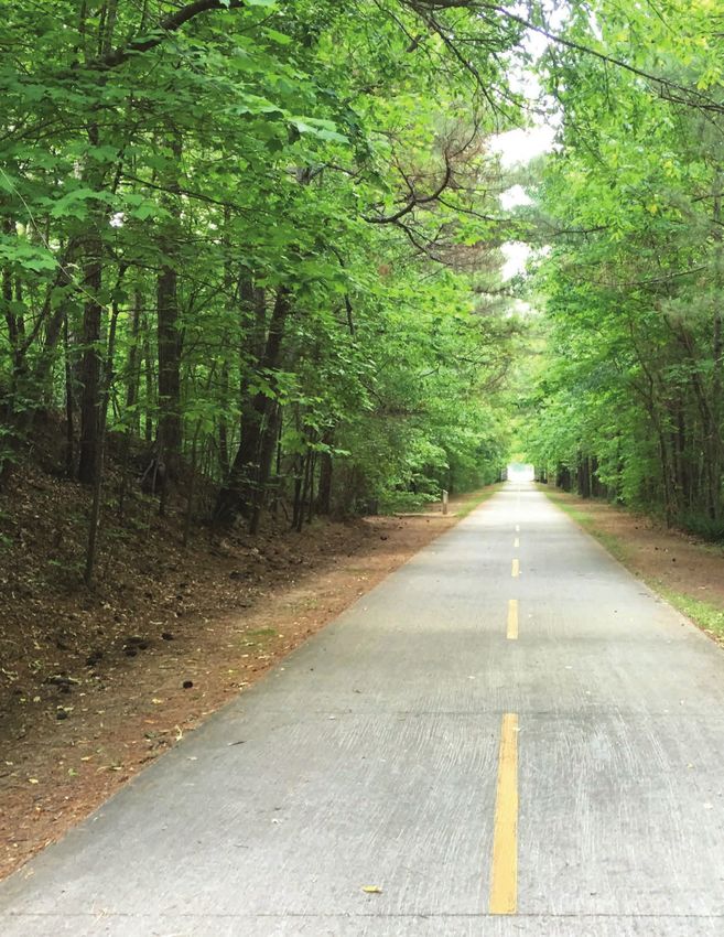
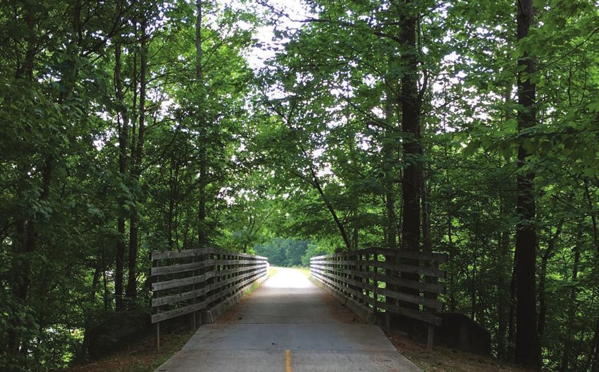
The road network includes all The Silver Comet Trail is a major The fiber network begins to tell
state and county roads, and all resource for the county because us where development is likely
the local roads and paths that it is a protected public area and to occur in the future, as the
lead to subdivisions and within the amount of travelers using new technology expands and
subdivisions. The road network is it annually make it important is in higher demand. Major
not extensive or well-connected, for both economic development developments dependent on
which is a concern because the and tourism. information technology will
roads should be linking things begin to cluster along those
together – creating ways to get from areas.
place to place.
Following an analysis of the environmental conditions, the team studied the infrastructure system in
the county to determine where future development is appropriate, and where it may be less desirable
in terms of provision of service and infrastructure capacity. Infrastructure includes all the framework
elements for development to occur – a road network, sewer and water pipes, schools – as well as
a history of development to see existing development patterns that have resulted from past county
decisions.
16 Paulding County Land Use PlanMAP 2.10 MAP 2.11 MAP 2.12
PARCELS SERVED BY SEWER SUBDIVISION HISTORY SCHOOL LOCATIONS
The distribution of these The suburban development map Schools are a part of public
locations is a problem because does not show a strong trend infrastructure because their
sewer locations appear to of development in a particular locations influence development
be responding to developer area, but is scattered across the and traffic.
demand rather than intention county. When this information
by the county. Many of the is combined with the sewer
sewer lines go through vacant data, it is revealed that there is
parcels and are detached from a significant reliance on septic
one another. The entire drainage tanks or slow connection to the
basin in gray is effected by any sewer system.
parcel served by sewer.
Growth influences are from the southern edge of the county closer to Interstate 20, as well as from the
east, closer to metropolitan Atlanta. Regionally, Paulding County is still relatively rural as compared to
other counties surrounding metropolitan Atlanta.
However, the location of sewer in the county has been the primary driver of both residential and
commercial development over the past 30-40 years. Sewer line locations are scattered across the
eastern and southern portions of the county – through vacant lots, and sometimes not connected to a
larger network. This appears to have been “on-demand” by developers rather than a planned approach to
growth that is both logical and cost-effective.
Analysis 17ENVIRONMENTAL analysis
HYDROLOGY + WETLANDS
IMPAIRED STREAMS
GROUNDWATER RECHARGE AREAS
FEMA FLOODPLAINS
PRIORITY ECOLOGICAL AREAS
SLOPE ANALYSIS
MAP 2.13
When the infrastructure data is layered, concentration of these systems within the eastern portion of the
county is revealed. This suggests that about a quarter of the county is already served by sewer, and the
southern half of that is an area that is primarily on septic.
The development in these areas should be appropriately controlled so that sewer system expansion is
planned in a logical and effective way, and new septic opportunities are carefully considered in light of
their location.
18 Paulding County Land Use PlanInfrastructure analysis
ROAD NETWORK
SILVER COMET TRAIL
FIBER NETWORK
PARCELS SERVED BY SEWER
SUBDIVISION HISTORY
SCHOOL LOCATIONS
MAP 2.14
The environmental and infrastructure analysis suggest that the western half the county should remain in
a conservation area with limited development, and the other eastern half of the county is the more logical
location for future development, as services, most significantly sewer, have already been invested in here
and the capacity to absorb development still exists in those systems.
Analysis 1920 Paulding County Land Use Plan
Future
                          Development
The vision for the future of Paulding County creates a pattern of
development and growth that builds upon existing services and
infrastructure. This focus will allow for the County’s other goals
to be achieved as well: greater protection of natural resources,
better connectivity for all transportation modes, and maintaining
fiscal viability. The vision is based on the needs demonstrated in
the residential population forecasts and economic development
potentials. The Comprehensive Plan’s Character Areas create a
framework for the future for Paulding County to be a vibrant live,
work, and play community – highlighting its existing assets and
improving the quality of future developments.

The Paulding County Character Areas are based on three critical
concerns. First is existing infrastructure – roads, sewer and water
– and the need to infill new development where infrastructure now
exists and the necessity to wisely manage any future extensions.
Second are environmental and ecological issues which help to
define where future development should or should not occur.
Third is to provide for economic development in ways that are
fiscally and environmentally appropriate for Paulding County.

                                                   Future Development   21
The Character Areas are as follows:
• Conservation
• Community Residential
• Rural
• Corridors
• Crossroad Communities
In addition, Target Areas identify developments/projects that require attention because of their potential to
catalyze growth in sustainable ways.
22 Paulding County Land Use PlanThis emphasis on fiscal and environmental stewardship for Paulding County’s future must be accompanied
by sound regulations for subdivisions of land, land-uses, and infrastructure planning. Of particular
importance is subdivision regulation because of its role in binding land use regulations and provisions of
infrastructure. The Character Areas are defined in such a way that enable subdivision regulations to take a
primary role in the future planning and development. This means that each Character Area would have one
“district” within the overall County subdivision regulations. This is an innovation in the County’s land use
controls, but will be essential for a fiscally and environmentally sustainable future.
Future Development 23CHARACTER AREAS
Conservation
SPECIFIC LAND USES CONSERVATION VISION STATEMENT:
Maintain natural, rural character and protect and enhance
ALLOWED IN THE environmentally sensitive areas.
CONSERVATION
The Conservation Character Area is defined by the specific boundaries
CHARACTER AREA:: of hydrologic drainage basins that have significant environmental or
hydraulic importance and are not currently served by sewer. Driven
Agriculture;
Conservation; by the environmental analysis described in the previous section, the
Municipal or public use; Conservation Character Area covers the majority of the western portion of
Bicycles / Pedestrian Paulding County and includes groundwater recharge areas, existing WMA
trails; Passive recreation;
and preserved lands, priority ecological areas, and the future reservoir.
Wildlife and fisheries
management Environmental Planning Criteria developed by the Department of Natural
Resources and enforced by DCA require local governments to protect
groundwater recharge areas within their jurisdictions. If followed, the
proposed subdivision regulations for this Character Area would ensure the
Compatible
County is complying with this aspect of the Criteria.
active zoning
SUBDIVISION REGULATIONS / KEY DEVELOPMENT PATTERNS
classifications: • Prepare and adopt a district-based subdivision ordinance for
this specific Character Area.
• Very large minimum lot size requirements (10+ acres) to limit
A-1: Agricultural
development density and protect, environmental resources,
farmland and rural character
• Preservation of environmentally sensitive areas by setting them
aside as public parks, trails, or greenbelts or various means of
land conservation and protection.
• Establish a policy to prohibit sewer and water extensions “on
demand” by developers and coordinate with new subdivision
district regulations and zoning amendments.
24 Paulding County Land Use PlanMAP 3.1 Future Development 25
CHARACTER AREAS

                                      Rural
                                      RURAL VISION STATEMENT:
      SPECIFIC LAND USES              Maintain rural character while allowing for residential development on
     ALLOWED IN THE rural             septic tank.

       CHARACTER AREA:                The Rural Character Area is defined by drainage basins that have
             Agricultural             neither significant environmental nor hydraulic importance and are
            Conservation              not currently served by sewer. However, the location is disconnected
             Residential              from major infrastructure networks. Any future development must limit
     1 Unit or Less per 2 acres       demand on county resources, specifically avoiding the need for sewer or
     Bicycles / Pedestrian trails;
         Passive recreation;          water extensions.
        Wildlife and fisheries
            management
                                      SUBDIVISION REGULATIONS / KEY DEVELOPMENT PATTERNS
                                         •   Prepare and adopt a district-based subdivision ordinance for
                                             this specific Character Area.
          Compatible                     •   Large minimum lot size requirements (2+ acres) or cluster
         active zoning                       development specifically designed for septic tank development.
                                             The aim is to limit development density and protect farmland
        classifications:                     and rural character, while prohibiting sewer and water
                                             extensions.
                                         •   Enlisting significant site features (view corridors, water
          A-1: Agricultural
                                             features, farmland, wetlands, etc.) as amenities that shape the
     R-2: Suburban Residential
               District                      identity and character of new development.
         NB: Neighborhood                •   Septic use should be carefully monitored based on State
             Business                        regulations and annual inspections.
                                         •   Hamlet type developments with buildings clustered at center,
                                             clearly defined edges surrounded by open space, as defined in
                                             a new district in the Paulding County Subdivision Regulations.

26    Paulding County Land Use Plan
MAP 3.3 Future Development 27
CHARACTER AREAS

                                     Community residential
                                     COMMUNITY RESIDENTIAL VISION STATEMENT:
      SPECIFIC LAND USES             Encourage walkable and interconnected residential developments that
        ALLOWED IN THE               highlight the natural environment.

          community                  The Community Residential Character Area is defined by specific
                                     hydrologic drainage basins that are currently served or expected to be
         residential                 served by sewer. Driven by the existing infrastructure and development
       CHARACTER AREA:               mapped in the previous section, the Community Residential Character
                                     Area includes the majority of eastern Paulding County. Development
           Residential,              should be concentrated around sewer access and the existing
       Public, Semi-Public,          undeveloped subdivisions. Any future developments must protect
           Institutional             floodplains, stream buffers and any other environmental concerns. This
                                     Character Area currently includes two impaired streams, resulting from
                                     nonpoint source pollution impacts. Following recommended subdivision
       Compatible active             regulations/key development patterns for this Character Area is
                                     consistent with efforts to manage the Total Maximum Daily Loads
            zoning                   (TMDLs) in these streams and, ultimately, remove them from impaired
                                     status. The recommendations also contemplate future nonpoint source
        Classifications:             pressures from additional development and the need to keep other
        R-4: Multi-Family            streams from being listed as impaired.
       R-6: Manufactured
             Homes                   SUBDIVISION REGULATIONS / KEY DEVELOPMENT PATTERNS
        R-7: Multi-Family               •   Prepare and adopt a district-based subdivision ordinance for
          PRD: Planned                      this specific Character Area.
     Residential Development
                                        •   Encourage clustered developments where appropriate.
        NB: Neighborhood
            Business                    •   Support infill development by creating new subdivision
     PSC: Planned Shopping                  regulation.
              Center                    •   New developments should contain a mix of residential,
                                            commercial uses and community facilities at a small
                                            enough scale and proximity to encourage walking between
                                            destinations.
                                        •   New developments should have smaller lots, orientation to
                                            the street, a mix of housing types, and pedestrian access to
                                            neighborhood amenities.
                                        •   New developments should contemplate every opportunity for
                                            green infrastructure and/or low impact design (LID) elements
                                            aspects of stormwater management to reduce the potential for
                                            Character Area streams to become impaired.

28   Paulding County Land Use Plan
MAP 3.2 Future Development 29
CHARACTER AREAS

                                     Corridors
                                     CORRIDORS VISION STATEMENT:
      SPECIFIC LAND USES             Maintain natural, rural character and protect and enhance
                                     environmentally sensitive areas.
        ALLOWED IN THE
          community                  The Corridors Character Area is defined by both the Silver Comet Trail
                                     as well as a section of Highway 278 from the eastern county line
         residential                 to Atlanta Highway (SR 6). Though these corridors are significantly
                                     different, both should be treated as arteries of the county where new
       CHARACTER AREA:               development can have significant impacts. Given the significant
       Bicycles / Pedestrian         amount of impervious area in the Highway 278 corridor, stormwater
     trails; Passive recreation;     management, with an emphasis on green infrastructure and/or low
      Public, Semi-Public, &         impact design (LID) should be a priority.
     Institutional, Commercial
                                     SUBDIVISION REGULATIONS / KEY DEVELOPMENT PATTERNS
                                        •   Prepare and adopt a district-based subdivision ordinance for
       Compatible active                    this specific Character Area.
                                        •   Commercial structures (shopping, offices, etc.) located
            zoning                          near street front, with parking in rear of buildings, making
                                            community more attractive and more pedestrian friendly.
        Classifications:                •   Co-joining of all parking lots to encourage park-once
                                            operations of commercial businesses to reduce or eliminate
          PRD: Planned
     Residential Development                mid-block curb cuts.
        NB: Neighborhood                •   Tree lawns or tree wells, with trees required on 25’ centers
             Business                       between sidewalks and roadway for pedestrian safety.
     PSC: Planned Shopping              •   Redevelopment of older strip commercial centers in lieu of
              Center                        new construction further down the strip.
      B-1: General Business             •   Improvement of sidewalk and street appearance and
      B-2: Highway Business
                                            amenities of commercial centers.
                                        •   Facilities for bicycles, including bikeways or bike lanes,
                                            frequent storage racks, etc.
                                        •   Developments have easy access to nearby transit, shopping,
                                            schools and other areas where residents travel daily.
                                        •   Street layouts that match those in older parts of the
                                            community and connect to the existing street network at
                                            many points.
                                        •   Urban design considerations of nodal development, shared
                                            parking, and integrating green infrastructure and/or LID
                                            should be employed to combat potential for large areas of
                                            impervious surface in these Character Areas.
30   Paulding County Land Use Plan
MAP 3.4 Future Development 31
CHARACTER AREAS

                                      Crossroad communities
                                      CROSSROADS VISION STATEMENT:
      SPECIFIC LAND USES              Needed amenities will be within close proximity to populations
                                      and reflect the scale and character appropriate to surrounding
     ALLOWED IN THE rural             neighborhoods.

       CHARACTER AREA:                The Crossroads Character Area is defined by the appropriate locations
            Commercial                of current or future nodal-based development for surrounding
            Multi-Family              residential communities. Some of these locations already have small
     Bicycles / Pedestrian trails;    commercial areas that currently exist and have developed to serve
         Passive recreation;          local needs. By adding more Crossroad locations, and clustering
                                      slightly higher-density development at these nodes and major
                                      corridor intersections, citizens can drive less and meet their needs
                                      closer to home. Development types will depend on the Character
          Compatible                  Area surrounding the Crossroad location, but should adhere to the
                                      key patterns below. Given the potential for significant amounts
         active zoning                of impervious area in heavily-developed Crossroads, stormwater
                                      management, with an emphasis on green infrastructure and/or low
        classifications:              impact design (LID) should be a priority.
         R-7: Multi-Family
     PRD: Planned Residential         SUBDIVISION REGULATIONS / KEY DEVELOPMENT PATTERNS
           Development                   •   Prepare and adopt a district-based floating subdivision
         NB: Neighborhood                    ordinance for this specific Character Area.
             Business                    •   Develop village-like crossroads shopping and commercial
      PSC: Planned Shopping                  service nodes. Although automobile related, parking should
              Center
       B-1: General Business                 clustered for joint use among tenants following a park-once
                                             means of parking requirements and regulations.
                                         •   Examine required parking in related zoning districts to allow
                                             parking reductions for mixed use projects where business
                                             intensity varies across the day and week.
                                         •   Redevelopment of older strip commercial centers at these
                                             locations in lieu of new construction further along the corridor.
                                         •   Well-designed development that blends into existing
                                             neighborhoods by disguising its density.
                                         •   Tree lawns or tree wells, with trees required on 25’ centers
                                             between sidewalks and roadway for pedestrian safety.
                                         •   Urban design considerations of nodal development, shared
                                             parking, and integrating green infrastructure and/or LID should
                                             be employed to combat potential for large areas of impervious
                                             surface in these Character Areas.
32    Paulding County Land Use Plan
SEWERED CROSSROADS
HIGH-INTENSITY CROSSROAD
SCT TRAILHEAD CROSSROAD
UNSEWERED CROSSROADS
MAP 3.5
Future Development 33CHARACTER AREAS
TARGET AREAS
As stated, Target Areas identify developments and/or projects that need
attention because of their potential to catalyze growth in the County.
Target Areas descriptions outline clear paths toward a more sustainable
Paulding County and take into account their locations within the
drainage basins. Details on how the County can be proactive about
potential future development patterns and growth in these areas are
outlined in this section.
THESE AREAS INCLUDE:
• The Cities of Dallas, Hiram, and Braswell
• Richland Creek Reservoir
• Silver Comet Trailheads
• Wellness District and WellStar Hospital
• Paulding County Airport
34 Paulding County Land Use PlanMAP 3.6 Future Development 35
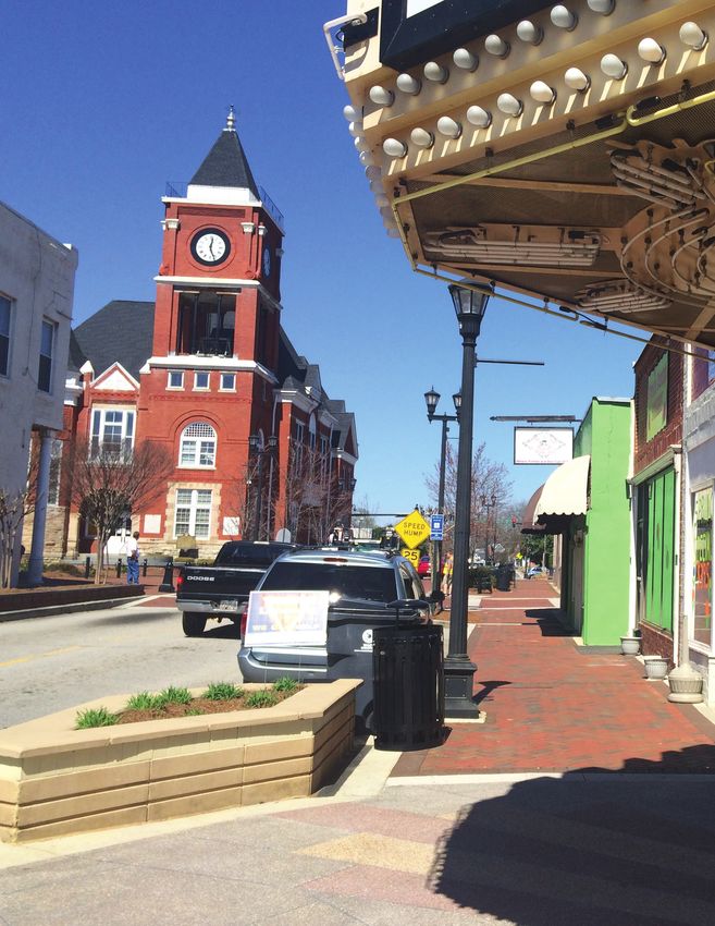
THE CITY OF DALLAS

                                     These historic municipalities are character-defining amenities within the
                                     county and should be considered as key assets to highlight and enhance.
                                     In addition to the Key Development Patterns listed for the Community
                                     Residential Character Area, these downtown areas should also consider:

                                     KEY DEVELOPMENT PATTERNS
                                        •   Enhance pedestrian-friendly environment by adding sidewalks
                                            and creating other pedestrian-friendly trail/bike routes
                                            linking to other neighborhood amenities, such as libraries,
                                            neighborhood centers, health facilities, parks, schools, etc.
                                        •   Prioritize development in size, scale, and character of existing
                                            historic buildings.
                                        •   Parking lots should not be visible from the street and shared
                                            parking opportunities should be available and encouraged.
                                        •   Street furniture should be implemented at appropriate locations
                                            downtown as well as nearing the Silver Comet Trail trailheads.
                                        •   Design features that encourage safe, accessible streets should
                                            be employed – such as narrower streets, on-street parking,
                                            sidewalks, street trees, and landscaped medians for minor
                                            collectors and wider streets.
                                        •   The downtown areas should include a mix of retail, services,
                                            offices, and housing as appropriate to serve neighborhood
                                            residents’ daily needs.

36   Paulding County Land Use Plan
THE CITY OF HIRAM
These historic municipalities are character-defining amenities within the
county and should be considered as key assets to highlight and enhance.
In addition to the Key Development Patterns listed for the Community
Residential Character Area, these downtown areas should also consider:
KEY DEVELOPMENT PATTERNS
• Enhance pedestrian-friendly environment by adding sidewalks
and creating other pedestrian-friendly trail/bike routes
linking to other neighborhood amenities, such as libraries,
neighborhood centers, health facilities, parks, schools, etc.
• Prioritize development in size, scale, and character of existing
historic buildings.
• Parking lots should not be visible from the street and shared
parking opportunities should be available and encouraged.
• Street furniture should be implemented at appropriate locations
downtown as well as nearing the Silver Comet Trail trailheads.
• Design features that encourage safe, accessible streets should
be employed – such as narrower streets, on-street parking,
sidewalks, street trees, and landscaped medians for minor
collectors and wider streets.
• The downtown areas should include a mix of retail, services,
offices, and housing as appropriate to serve neighborhood
residents’ daily needs.
Future Development 37THE CITY OF BRASWELL
These historic municipalities are character-defining amenities within the
county and should be addressed as key assets to highlight and enhance.
In addition to the Key Development Patterns listed for the Community
Residential Character Area, these downtown areas should also consider:
KEY DEVELOPMENT PATTERNS
• Enhance pedestrian-friendly environment by adding sidewalks
and creating other pedestrian-friendly trail/bike routes
linking to other neighborhood amenities, such as libraries,
neighborhood centers, health facilities, parks, schools, etc.
• Prioritize development in size, scale, and character of existing
historic buildings.
• Parking lots should not be visible from the street and shared
parking opportunities should be available and encouraged.
• Design features that encourage safe, accessible streets should
be employed – such as narrower streets, on-street parking,
sidewalks, street trees, and landscaped medians for minor
collectors and wider streets.
• The downtown areas should include a mix of retail, services,
offices, and housing as appropriate to serve neighborhood
residents’ daily needs.
38 Paulding County Land Use PlanRICHLAND CREEK RESERVOIR
The Richland Creek Reservoir project is a new 305-acre reservoir that will
store over three billion gallons of drinking water to supply existing and
future populations in Paulding County. It is anticipated to be completed
by 2019. Because this water source is vital to future populations in the
county, the water quality and quantity must be protected through careful
surrounding development. A master plan for this drainage basin should
be pursued to protect the water source. Environmental Planning Criteria
developed by DNR and enforced by DCA require local governments
to protect water supply watersheds within their jurisdictions. If the
recommendation to create a master plan for this drainage basin is followed,
the County would ensure compliance with this aspect of the Criteria.
KEY DEVELOPMENT PATTERNS
• Promote use of conservation easements by landowners.
• Residential subdivisions should be severely limited, but if minor
exceptions are made, they should be required to follow a rural
cluster zoning or conservation subdivision design.
• Promote this area for passive-use tourism and recreation
destination.
• Protect land and open land by maintaining large lot sizes (at
least 5 acres).
• Ensure adoption of drinking water supply watershed buffers in
applicable ordinances (Environmental Planning Criteria, Part V).
• Ensure regular coordination throughout the year of the County’s
community development, zoning, and stormwater management
personnel in relation to the Reservoir Target Area on priorities
for supply watershed protection and any challenges to protection
(recommendation of the Metro Water District).
Future Development 39SILVER COMET TRAILHEADS
Silver Comet Trailheads are the key locations for a user to access the
trail and travel along it. These trailheads should accommodate the needs
of residents and visitors with water, restrooms, and other amenities.
The development surrounding a trailhead should respond to the more
pedestrian- and bike-friendly environment. There are four trailheads
located within Paulding County. These are:
• Hiram at Homer Leggett Park
(includes nearby restrooms (at park), a dog park, but there is
an at-grade crossing with a road)
Seaboard Ave, Hiram, GA 30141
• Paulding Chamber of Commerce
(includes portable toilets, parking)
455 Jimmy Campbell Pkwy, Dallas, GA 30132
• Tara Drummond Park
(includes restrooms, parking, benches, rose gardens and
fountains)
820 Seaboard Ave, Dallas, GA 30157
• Rambo Nursery
(includes parking, portable toilets, benches)
25 Tucker Blvd, Dallas, GA 30157
Because of their proximity to the historic cities of Dallas and Hiram, the
key development patterns for the Hiram and Tara Drummond Trailheads
will be addressed differently.
40 Paulding County Land Use PlanCHAMBER OF COMMERCE AND RAMBO NURSERY TRAILHEADS
KEY DEVELOPMENT PATTERNS
• Design should be very pedestrian-oriented, with clear, walkable
connections between different uses.
• Provide bike lanes or wide curb lanes to encourage bicycling
and provide additional safety, provide conveniently located,
preferably sheltered bicycle parking at retail and office
destinations and in multi-family dwellings.
• Design features that encourage safe, accessible streets should
be employed – such as narrower streets, on-street parking,
sidewalks, street trees, and landscaped medians for minor
collectors and wider streets.
• Particular attention should be paid to signage to prevent visual
clutter. Encourage way-finding signage at an appropriate scale.
• Road edges should be clearly defined by locating buildings at
roadside with parking in the rear. Shared parking and maximum
parking limits should be encouraged.
Future Development 41HIRAM & TARA DRUMMOND TRAILHEADS
KEY DEVELOPMENT PATTERNS
• Design should be very pedestrian-oriented, with clear, walkable
connections between different uses.
• Provide bike lanes or wide curb lanes to encourage bicycling
and provide additional safety, provide conveniently located,
preferably sheltered bicycle parking at retail and office
destinations and in multi-family dwellings.
• Design features that encourage safe, accessible streets should
be employed – such as narrower streets, on-street parking,
sidewalks, street trees, and landscaped medians for minor
collectors and wider streets.
• Particular attention should be paid to signage to prevent visual
clutter. Encourage way-finding signage at an appropriate scale.
• Road edges should be clearly defined by locating buildings at
roadside with parking in the rear. Shared parking and maximum
parking limits should be encouraged.
42 Paulding County Land Use PlanWELLSTAR HOSPITAL and WELLNESS DISTRICT
The WellStar Hospital is a key amenity within Paulding County, providing
jobs as well as hospital services for a wide-ranging area. Growth
has already been seen around the hospital, and the county should
be proactive about this growth to maintain a quality district that is
accessible and attractive for all users and creates a resilient employment
center.
KEY DEVELOPMENT PATTERNS
• Design should be very pedestrian oriented, with clear, walkable
connections between different uses.
• Design features that encourage safe, accessible streets should
be employed – such as narrower streets, on-street parking,
sidewalks, street trees, and landscaped medians for minor
collectors and wider streets.
• Include a diverse mix of higher-density housing types, such as
multi-family town homes, apartments, lofts, condominiums,
including affordable and workforce housing.
• Particular attention should be paid to signage to prevent visual
clutter. Encourage way-finding signage at an appropriate scale.
• Parking should be handled on a district basis and parking
structures should be faced with retail at ground level when
possible.
Future Development 43PAULDING COUNTY AIRPORT
The Paulding Airport is located in the western-middle portion of the
county, surrounded primarily by greenspace and lands that are not
currently served by sewer. In advance of development in this Target
Area, a growth plan should be created to consolidate infrastructure
and influence the type of development the county desires in this
environmentally sensitive location.
KEY DEVELOPMENT PATTERNS
• Continue county investment in the special environment of this
larger Conservation Character Area through mindfulness of the
slopes, priority ecological areas, and habitat and watershed
impacts of any new development.
• New developments should be clustered or otherwise sited
thoughtfully so as to minimize disturbed areas and resulting
impervious surfaces.
• New developments should be considered in light of the limited
infrastructure services in this area of the county. Service demands
related to unplanned growth could unduly burden county services.
• Prioritize green infrastructure and/or low impact design (LID) for
any new development in this area.
• Prepare and adopt a growth plan for this Target Area.
44 Paulding County Land Use PlanFUTURE DEVELOPMENT MAP
Conservation
Character Area
Community Residential
Character Area
Rural
Character Area
Municipalities
Crossroads
Character Area
Corridors
Character Area
Target Areas
Future Development 4546 Paulding County Land Use Plan
Recommendations
The land use study involved consideration of existing natural and
built environment/infrastructure conditions; involved the review
of previous, relevant plans and studies; and included interviews
with representatives of authorities and entities having various
responsibilities related to Paulding County’s natural and built
environment, environmental compliance, and service provision
to the county’s citizens and businesses. This approach was
undertaken in order to identify common goals and opportunities,
to arrive at multi-benefit investments of time and effort through
land use recommendations, and to uncover any conflicts among
the previous plans and responsibilities in order to address those
conflicts within the land use plan. The study team found common
goals and critical leverage opportunities among the various plans
and relevant authorities, adding further merit and importance to
the recommendations documented in this report.

Existing plans and relevant documents reviewed included,
among others: City of Dallas Livable Centers Imitative (2010)
and its 2013 Update; City of Hiram Livable Centers Initiative
(2014); Paulding County Comprehensive Plan (2007); Paulding
County Comprehensive Transportation Plan (2016); Economic
Development Study undertaken concurrent with this land use
study (2016-17); Georgia Stormwater Management Manual;
Metro Water District’s Water Supply and Water Conservation
Management Plan; Metro Water District’s Watershed Management
Plan; Metro Water District’s Wastewater Management Plan; and
Paulding County’s Municipal Separate Storm Sewer System (MS4)
NPDES permit.

The major recommendations contained within this land use study
are consistent with the themes and goals of the reviewed plans
and documents, with differences existing only in recommended
execution to achieve those goals and themes. All the Metro
Water District’s plans emphasize the need for a watershed-
based approach to land use planning as a remedy for water
quality and quantity challenges. Further, interviews with Metro
Water District staff indicate the increased reliance the Metro
Water District will make in its upcoming plan revision (2017)
on green infrastructure and/or low impact design (LID) and land
conservation in addressing stormwater management. Staff also

                                                   Recommendations   47
indicated that the December 2017 renewal of Paulding’s MS4 permit will rely on the County’s increased
investment in managed growth, green infrastructure/LID, and land/greenspace conservation. LCI plans for
Dallas and Hiram clearly highlight the need for downtown infill, residential opportunity, relative density and
connections to the respective Silver Comet trailheads as redevelopment strategies. Finally, the economic
development study findings, undertaken concurrent to this land use study, heavily emphasize infill, Hiram
and Dallas revitalization, Silver Comet investment, character retention, the hospital district, the airport and
fiscal responsibility with public infrastructure investments as priorities to realize optimum economic activity
in the county. All of these plan priorities are reflected in this land use study and its Work Program.
Compact development, strategic infrastructure decisions and a new emphasis on green infrastructure and/
or low impact design (LID) will maintain the fiscal capabilities of the county while accommodating growth,
retaining character and cost of living that makes it a competitive location for residents and businesses.
It is imperative that the County direct its future growth and avoid situations of having individual property
needs generate piecemeal County investment. To accommodate anticipated growth, the County must firmly
be in the decision-maker role relative to all infrastructure decisions. Further, growing emphasis by various
regulatory entities centers on managed land-use development through a watershed planning perspective of a
responsible water steward. Adopting this plan’s recommendations positions the county to simultaneously be
fiscally responsible, compliant with water resource management requirements, and a savvy guardian of the
county’s key competitive advantage—its green character and attractive landscape.
Central to the recommendations of this land use study are creation and adoption of the district-based
subdivision ordinances recommended for each character area. The adoption of these districts will then
direct all related land development elements such as infrastructure investment and connectivity, among
others. This, then, establishes the framework by which the county will achieve the necessary growth
48 Paulding County Land Use Planaccommodation, fiscal accountability and competitive edge among Metro Atlanta counties that this report
has repeatedly stressed. The scattered subdivision and commercial area development example of other
Metro Atlanta counties should serve as cautionary tales for Paulding. Further, as detailed in the Economic
Development Strategic Plan, Paulding County will likely remain predominantly residential aside from key
employment centers and opportunities. It is a fact that residential-based tax income will not cover the
County’s full cost of residential service demands. The more money that saved through the county’s strategic
infrastructure investments and managed growth, the more fiscally stable the county will be in the long-term
while also keeping down costs passed to residents and businesses.
The county’s current subdivision ordinance is a quality ordinance that this report simply finds needs to
reflect the different conditions across the county. As documented in previous report sections, Paulding
County has diverse environmental conditions to which a one-size-fits-all subdivision ordinance is not
best positioned to address. Creating and adopting the recommended Character Area districts will best
address this need. The land use report does not recommend a cessation to development in the county
but, rather, recommends directing it to accommodate the projected population growth while keeping the
county financially stable while retaining, on the whole, the landscape character citizens cited as invaluable
throughout the extensive comprehensive planning process public engagement.
Finally, the other gems of Paulding County are its small towns, Silver Comet Trail, highly-respected hospital
facility, crossroad communities and new reservoir. Findings in this report align with findings in the Economic
Development Strategic Plan that emphasize these resources as key character, development and economic
opportunities. Recommendations in the land use report were tailored to supporting these resources and
cultivating greater benefit from them.
Recommendations 49The following work program specifies action items recommended to arrive at the future land use
management found most appropriate for the county. Several of these recommendations are no- or low-
cost and center around formalizing coordination and relationships with existing government, institutional,
and civic partners. Several of these recommendations are achievable with existing county staff labor. The
success of all land use study recommendations will require the county to fully embrace public education and
awareness-building around the over arching comprehensive plan’s goals and necessities to reach those goals.
Specific interaction with major property owners in the county would be of tremendous benefit in successfully
adopting the recommendations. This land use team endeavored to affirm county responsibilities and
opportunities while being innovative in how to best honor those responsibilities and leverage opportunities
with manageable costs.
Taxes do not pay for services for residential development. The more money that can be saved by the county
in building roads and infrastructure and maintaining roads and infrastructure, the better off the county will
be in the long-term and will keep taxes down. This is a fiscal issue that is very important.
50 Paulding County Land Use PlanWORK PROGRAM: pAULDING COUNTY
SHORT TERM WORK PROGRAM, 2017 - 2021
PAULDING COUNTY – FINAL
TIMEFRAME
Responsible Cost Funding
PROJECT / ACTIVITY DESCRIPTION
Agency / Dept. Estimate Source
2017 2018 2019 2020 2021
CG-1: PROTECT NATURAL RESOURCES
Create clear and user-friendly Zoning Ordinance and Develop-
ment Regulations for Character Areas consistent with the
2017 Comprehensive Plan land use recommendations including:
1) Large lot zoning in areas with sensi-
tive soils, steep slopes and no public sew-
er 2)
Incentives for use of green infrastructure in stormwater man-
agement 3)
Land use plan for the reservoir water- General
PCWP Community
shed area in advance of growth influenc- × × × × × $200,000
- 01 Development Fund
es 4) District
planning where growth in different areas of the county matches
the character area and does not overcommit sewer capac-
ity 5)
More mixed use housing types - including work force and miss-
ing middle 6)
Multi-family housing standards
7) Broadly communicate changes
8) Cluster commercial development at targeted crossroads
In partnership with the DNR, develop a process to:
1) Identify WMA encroachment
issues 2) Minimize the impact of Paulding Fixed
PCWP growth on the WMA × × × × × County + $0
- 02 Labor
3) Evaluate potential of WMA (educational and economic) Georgia DNR
4) Monitor land use along WMA border
5) Collaborate on WMA-related issues long term
Develop a Parks and Recreation Master Plan to include:
PCWP 1) Feasibility of developing a “Sports” industry sector Parks & General
× × $100,000
- 03 beginning with a major regional competitive sports facility Recreation Fund
2) Utilization of greenspace opportunities
CG-2: TARGET GROWTH
Create clear and user-friendly Character Area Zoning Ordinance
and Development Regulations consistent with the updated
Comprehensive Plan land use recommendations to include:
1) District planning where growth in different
areas of the county matches the character
area and does not overcommit sewer capacity Community General
PCWP 2) More mixed use housing types - × × $2000,000
- 04 Development Fund
including work force and missing middle
3) Multi-family housing standards
4) Promotion of quality growth
5) Subdivision road connectivity
6) Broadly communicate the changes
7) Cluster commercial development at targeted crossroads
Develop, in partnership with Hiram, WellStar Hospital and
other stakeholders a Wellness Corridor study to include:
1) Quality growth and develop- Paulding Grant
PCWP ment 2) Connectivity × × County and $100,000 plus local
- 05 3) Related medical and health services uses City of Hiram match
4) Potential for LCI corridor funding
5) Consideration of special funding district
Water
PCWP Conduct a Sewer System Master Plan as part of the Water Water &
× × × × $6,000,000 Enterprise
- 06 System Master Plan Sewer System
Fund
Paulding County Land Use Plan 51WORK PROGRAM: pAULDING COUNTY
SHORT TERM WORK PROGRAM, 2017 - 2021
PAULDING COUNTY – FINAL
TIMEFRAME Responsible Cost Funding
PROJECT / ACTIVITY DESCRIPTION Agency /
Dept. Estimate Source
2017 2018 2019 2020 2021
CG-3: LEVERAGE ASSETS
Board of General
PCWP Adopt the Economic Development Strategic Plan (EDSP) for the × × × × × Commission- $1,000
- 07 County and market it to the community Fund
ers
Develop and submit, along with other MJW agencies, a
joint recommendation for organizing countywide Economic
Development (ID and assess a mixture of highly effective General
PCWP MJW
organizational structures as precedence to identify roles, × × × × × $20,000
- 08 Partners Fund
responsibilites and expectations for an approach to business
retention and development that results in a healthy economy and
consistent local funding)
Approve and fund a 10-year commitment to an Economic Board of General
PCWP Development organizational structure, including staffing, that will × × × × × Commission- $2,500,000
- 09 be charged with attracting resources, assets and investment to Fund
ers
expand and maintain a healthy economy
EDO and
PCWP Develop a plan to market land/building assets including developing
× × × × × Chamber of $25,000
- 10 shovel ready sites
Commerce
PCWP Community General
Create a County-Wide Brand × × $25,000
- 11 Development Fund
Design and install gateway signs at Paulding County boundaries
PCWP Community General
on major access highways; especially Highway 278 approaching × × × × $300,000
- 12 Development Fund
from the East
In parternship with MJW agencies, design and install directional Paulding
Local
PCWP signage from the Silver Comet Trail to downtown Dallas, Hiram, County +
× × $15,000 + MJW
- 13 Braswell and other PC locations (in partnership with PC, Hiram, MJW Part-
Partners
Braswell, PC DOT) ners
Paulding
PCWP County Fixed
Promote Silver Comet Trail in county printed and on-line material × × × × × $0
- 14 All Labor
Departments
Develop an assessment process to identify, prioritize and fund Board of
PCWP infrastructure maintenance and improvement projects key to × × × × × Commission- $0 SPLOST
- 15 economic growth and development ers
Community
Development
Review and udpate if necessary the airport area master
+ Economic
development plan to encourage development of a business/ General
PCWP × × × × × Development $1,500,000
- 16 technology park and continue to promote the airport's new, clean Fund
Office +
and safe facilities
Airport
Authority
PCWP Community
Complete National Stabilization Program (NSP 3) × $0
- 17 Development
52 Paulding County Land Use Plan Recommendations 52You can also read