Amendment C171 Melton Planning Scheme - Expert witness statement of Chris Abery, Deep End Services Prepared for Ranfurlie Developments Pty Ltd 20 ...
←
→
Page content transcription
If your browser does not render page correctly, please read the page content below
Amendment C171 Melton
Planning Scheme
Expert witness statement of
Chris Abery, Deep End Services

Prepared for Ranfurlie Developments Pty Ltd
20 March 2017
Deep End Services
Deep End Services is an economic research and property consulting
firm based in Melbourne. It provides a range of services to local and
international retailers, property owners and developers including due
diligence and market scoping studies, store benchmarking and
network planning, site analysis and sales forecasting, market
assessments for a variety of land uses, and highest and best use
studies.
Contact
Deep End Services Pty Ltd
Suite 304
9-11 Claremont Street
South Yarra VIC 3141

T +61 3 8825 5888
F +61 3 9826 5331
deependservices.com.au
Enquiries about this report should be directed to:
Chris Abery
Principal
Chris.abery@deependservices.com.au
Document Name
Am C171 Chris Abery witness statement (FINAL)- 17 March 2017
20.03.17

Disclaimer
This report has been prepared by Deep End Services Pty Ltd solely for use by the party to whom it is
addressed. Accordingly, any changes to this report will only be notified to that party. Deep End
Services Pty Ltd, its employees and agents accept no responsibility or liability for any loss or damage
which may arise from the use or reliance on this report or any information contained therein by any
other party and gives no guarantees or warranties as to the accuracy or completeness of the
information contained in this report.

This report contains forecasts of future events that are based on numerous sources of information as
referenced in the text and supporting material. It is not always possible to verify that this information is
accurate or complete. It should be noted that information inputs and the factors influencing the
findings in this report may change hence Deep End Services Pty Ltd cannot accept responsibility for
reliance upon such findings beyond six months from the date of this report. Beyond that date, a review
of the findings contained in this report may be necessary.

This report should be read in its entirety, as reference to part only may be misleading.
Contents

Introduction                                                                          1
1.1 Name & address of expert                                                          1
1.2 Experts qualifications & experience                                               1
1.3 Expert’s area of expertise                                                        2
1.4 Expertise to make report                                                          2
1.5 Documents, materials, and literature used in preparing this report                2
2     Melton Retail and Activity Centres Strategy                                     3
2.1 Amendment C171 Melton Planning Scheme                                             3
2.2 Economic and Policy context                                                       4
2.3 MRACS Methodology                                                                 5
      Population and spending                                                         5
      Floorspace demand                                                               5
      Scope for New Centres                                                           6
      Catchment analysis                                                              7
2.4 Activity Centre expectations                                                      8
2.5 Caroline Springs findings                                                         9
2.6 Burnside findings                                                                 9
3     Burnside Activity Centre                                                       12
3.1 Location                                                                         12
      Regional setting                                                               12
      Regional population growth                                                     13
      Regional roads connections & traffic volumes                                   16
      Surrounding employment growth                                                  18
3.2 Burnside activity centre                                                         19
3.3 Burnside Hub                                                                     21
3.4 Extended centre                                                                  21
3.5 Extended MRACS Catchment area                                                    22
3.6 The case for a DDS at Burnside                                                   24
3.7 Burnside meeting the expectations for Activity Centres                           26
4     Activity centres hierarchy                                                     28
4.1 Melton East Structure Plan Activity Centre Framework (1997)                      28
4.2 Activity Centre Network                                                          30
4.3 Comparable spaced centres                                                        32
4.4 Impacts                                                                          33
4.5 Benefits                                                                         35
5     Conclusions                                                                    36

Appendices
Appendix A Curriculum Vitae – Chris Abery

Amendment C171 Melton Planning Scheme—20 March 2017                      Deep End Services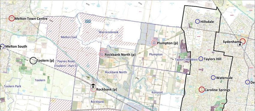
Tables + Figures
Table 1—Population growth 15
Table 2—Burnside Hub existing floorspace 21
Table 3— Core catchment area populations 22
Table 4—Activity Centre floorspace 32
Figure 1—Sub regional catchments from MRACS 8
Figure 2—MRACS Final Proposed Activity Centre Network 11
Figure 3—Regional location 13
Figure 4—Population areas 15
Figure 5—Regional road connections 16
Figure 6—Traffic volumes 2015 (vehicles per day) 18
Figure 7— Commercial and Industrial land available - 2016 19
Figure 8—Burnside Activity Centre – February 2017 20
Figure 9—Adjusted MRACS catchments 23
Figure 10—DDS provision outer west 26
Figure 11—Melton East Strategy Plan (1997) Activity Centre Framework 29
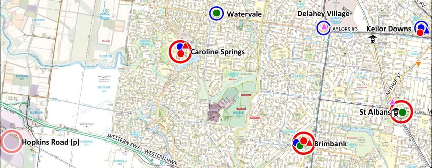
Figure 12—Activity Centre Network 31
Figure 13—Relative locations of Activity Centres and other DDS-based
centres 33
Amendment C171 Melton Planning Scheme—20 March 2017 Deep End Services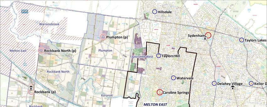
1
Introduction 01 My name is Chris Abery. I am a Principal of Deep End Services, a consulting firm
which practices in retail analysis and property economics. My statement has been
prepared to assist the review by Planning Panels Victoria of Amendment C171 (the
Amendment) to the Melton Planning Scheme.
02 My instructions from Minter Ellison on behalf of Ranfurlie Developments Pty Ltd
(owners of Burnside Hub Shopping Centre and surrounding land) are to review the
Amendment and provide expert retail and economic evidence in relation to
Burnside’s proposed designation as an Activity Centre under the Melton Retail and
Activity Centres Strategy (MRACS) and Clause 21.05 of the Melton Planning
Scheme.
03 In preparing this report I have inspected the site, surrounding areas and shopping
centres. I have reviewed the Melton Planning Scheme and the Melton Retail and
Activity Centres Strategy.
04 In arriving at my conclusions, I have made all the inquiries that I believe are desirable
and appropriate and no matters of significance that I regard as relevant have, to my
knowledge, been withheld from the Panel.
1.1 Name & 05 Mr Chris Abery
address of expert Principal
Deep End Services Pty Ltd
Suite 304 / 9-11 Claremont Street
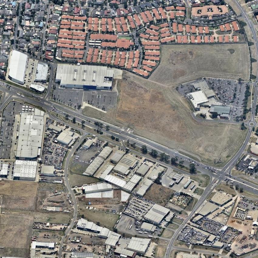
South Yarra Victoria 3141
1.2 Experts
qualifications & 06 Bachelor of Town and Regional Planning, University of Melbourne
experience
07 Graduate Diploma Social Statistics, Swinburne Institute
08 I have 32 years’ experience in spatial modelling, retail and market analysis and
property economic evaluation.
09 I have been a Principal of Deep End Services, a property and retail economics
consultancy since June 2009, where I have worked with national retail clients,
shopping centre owners and developers on need and demand assessments, network
planning and economic impact evaluations.
10 I was a Director in the Property Economics unit of Urbis between March 2007 and
April 2009.
11 I have held senior roles in the Property Team at Coles Myer Ltd between 1992 and
2007 including as National Manager Strategy and Property Analysis. In that role, I
lead a team responsible for the network planning of Coles Myer retail businesses
across Australia, forecasting turnover of all new store proposals, due diligence of
property and business acquisitions, urban planning advice and general market
advice to senior management and the Coles property team.
12 Between 1986 and 1992 I was employed as a consultant with Ratio Consultants, an
economics and urban planning consultancy.
13 A full CV is included at Appendix 1.
Amendment C171 Melton Planning Scheme—20 March 2017 Deep End Services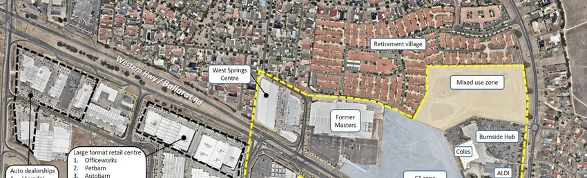
2
1.3 Expert’s area 14 Development and execution of turnover forecasting models for new retail stores
of expertise including supermarkets, discount department stores, department stores, liquor
stores and fast food outlets for retailers and shopping centre owners.
15 Market assessments and turnover forecasts for new or expanding retail centres.
16 Preparation of demand and supply studies on supportable levels of retail and
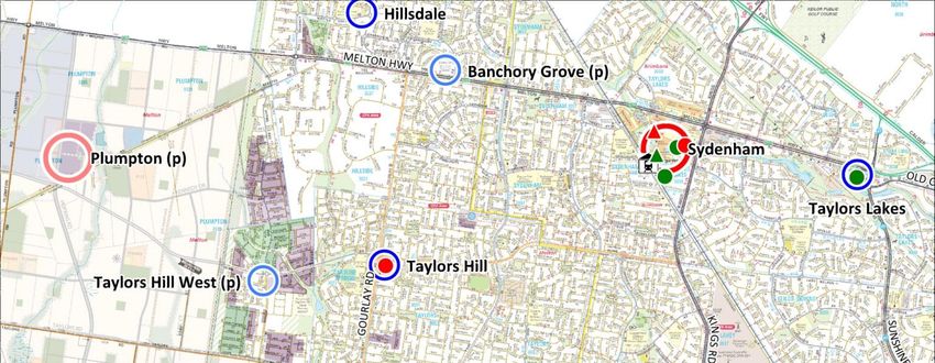
commercial floorspace in growth areas and established markets.
17 Analysis of consumer data and research relating to retailing and shopping centre
developments.
18 Spatial analysis of customer data to model retail catchments and market shares for
the purpose of sales forecasting.
19 Market research and commercial advice in relation to the recommended land use,
layout, size, facility mix, turnover and rents of mixed use developments.
20 Preparation of economic impact assessments for proposed retail developments and
expert witness evidence.
1.4 Expertise to 21 Detailed knowledge of Australian retail and shopping centre operations and impacts
make report resulting from development of new supermarkets and other retail facilities.
22 Long term involvement with retailers and owners and developers of shopping
centres.
23 Preparation of evidence for and appearances at Planning Panels, Appeal Tribunals,
Licensing Boards and courts in Victoria, Tasmania and New South Wales.
1.5 Documents, 24 Amendment C71 Melton Planning Scheme
materials, and 25 City of Melton Retail & Activity Centres Strategy
literature used in
preparing this 26 Australian Bureau of Statistics Census and other published data
report
Amendment C171 Melton Planning Scheme—20 March 2017 Deep End Services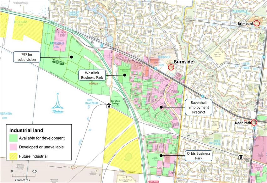
3

Melton Retail and Activity Centres Strategy

                  27   This section reviews the economic and policy context for the MRACS and the
                       assumptions and analysis which lead to the findings in relation to the Burnside
                       Activity Centre.
2.1 Amendment     28   Amendment C171 implements the recommendation of the City of Melton Retail and
C171 Melton            Activity Centres Strategy, March 2014 by amending the Municipal Strategic
Planning Scheme        Statement and Local Planning Policy.
                  29   The Amendment inserts a new Clause 21.05 (Activity Centres and Retail Provision)
                       and updates the existing Clause 22.06 (Retail Policy). Clause 21.05 introduces a new
                       hierarchy of activity centres in the municipality with new Objectives and Strategies.
                  30   Clause 21.05-4 (Activity Centre Network) contains Map 1: City of Melton Activity
                       Centre Hierarchy: Supportable Network of activity centres at full development
                       which identifies Burnside as one of four existing ‘Activity Centres’ along with four
                       new Activity Centres. Under this clause, Burnside its upgraded from its current
                       designation as a neighbourhood centre.
                  31   Clause 21.05-4 also contains Table 1 (City of Melton Activity Centre Hierarchy)
                       which sets out the ‘Land Use Strategies’ for each level in the hierarchy. Activity
                       Centres sit below Metropolitan Activity Centres and are to be encouraged to
                       develop the following land uses:
                                 •     A broad mix of integrated sub regional land uses such as retail (discount
                                       department store as well as supermarkets and specialty stores), office,
                                       business, community, education and residential.
                                 •     Residential development (usually above ground level) and medium and
                                       higher density housing in close proximity.

                       Amendment C171 Melton Planning Scheme—20 March 2017                            Deep End Services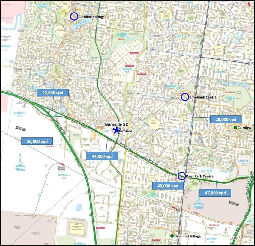
4

                                     •     Accessibility via public transport including a public transport interchange
                                           and pedestrian and cycling networks.
                                     •     Extensive public open space.
                                     •     Approximately 35,000 square metres of conventional retail floorspace
                                           and up to 20,000 square metres of restricted retail floor space based on a
                                           catchment of approximately 50,000 people.

2.2 Economic and   32   The need for a new Activity Centres Strategy stems from a range of economic and
Policy context          policy themes set out in the MRACS including:
                        •       The City of Melton’s population is projected to grow from 132,000 people in 2015
                                to 400,000 at full development over the next 30-40 years. This unprecedented
                                rate of growth requires both the redevelopment and expansion of existing
                                centres and a network of new centres to service the growth areas.
                        •       Surveys by Council showing residents want a higher level of service from their
                                activity centres, reducing the need to travel elsewhere.
                        •       Generating new job opportunities. Melton’s activity centres are vitally important
                                to generate a high proportion (up to 60%) of the 140,000 new jobs needed when
                                the municipality reaches full development.
                        •       A need to merge the activity centre planning undertaken by the former Growth
                                Areas Authority in Melton’s new areas (where the focus was on centre
                                hierarchies based on retail functions) with the latest metropolitan plan (‘Plan
                                Melbourne’) where the hierarchy of centres has been broadened with a focus on
                                jobs and services.
                        •       The new hierarchy of centres under ‘Plan Melbourne’ is:
                                    • National Employment Clusters
                                    • Metropolitan Activity Centres
                                    • Activity Centres
                                    • Neighbourhood Centres
                        •       The introduction of reformed commercial zones in Victoria in 2012. These were
                                designed to respond to changing market forces and provide greater flexibility
                                and growth opportunities by (amongst other things) broadening the range of
                                activities not requiring a permit, removing floorspace restrictions and allowing
                                limited retail uses in industrial zones. With the removal of floorspace caps, the
                                MRACS notes that “... the area of land to be zoned will be the principle control
                                on the size of the centre” 1.
                        •       ‘Plan Melbourne’ setting higher minimum densities within growth areas of 18
                                dwellings per hectare. This could have implications for the size and number of
                                activity centres to serve the growth areas.
                   33   The strategic planning studies for Melton East pre-date most of the area’s
                        development. There has been no review of activity centres since the Melton East
                        Structure Plan (MESP) was released in 1997. A review of the Indicative Activity
                        Centre Framework Plan within the MESP reveals several proposed centres failed to
                        materialise as the locations were poorly placed and the low floorspace caps only

                        1
                            MRACS Background Report p.40.

                        Amendment C171 Melton Planning Scheme—20 March 2017                                Deep End Services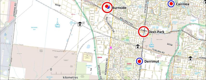
5

                   allowed small supermarkets which could no longer be secured by developers. While
                   Caroline Springs is now at the size contemplated by the MESP Activity Centres
                   Framework, the balance of the area has a much lower floorspace provision than
                   proposed in the MESP.

2.3 MRACS     34   The MRACS analysis is undertaken through various stages including:
Methodology
                   •       An analysis of existing centres including trade areas, floorspace, retail sales and
                           the results of a web-based survey of residents’ views about their centres.
                   •       Trends in activity centre planning and the retail and office sectors.
                   •       Policy developments.
                   •       Projected population at the municipal and small-area level and retail spending
                           levels at the municipal level.
                   •       Supportable retail floorspace at the municipal level at full development.
                   •       Organising floorspace needs into centres.
                   •       Resolving network issues.
              35   The major assumptions and conclusions are reviewed below.

                   Population and spending
              36   The MRACS takes population forecasts for the City of Melton from small area
                   projections prepared by .id consulting. By 2031, the municipal projections by .id
                   (242,000) are about higher 7% than the State Government’s forecasts (226,000)2.
                   The difference can be explained by different assumptions and normal variability in
                   forecasting over long time periods however both estimates represents an increase of
                   either 95,000 people or 109,000 people over the 2015 levels (133,000) – a range
                   which still shows significant growth and potential demand for new activity centre
                   floorspace.
              37   In examining the detailed .id estimates, I note the East Melton area covering
                   Caroline Springs, Taylors Hill, Burnside Heights and Burnside will increase from
                   48,713 people in 2016 and peak at 52,200 people in 2021. Across this sub-region, the
                   largest area of growth in the next 10 years is projected by .id at Burnside, based on
                   the large infill estate (Modeina) now developing off Westwood Drive, beginning 1.6
                   km north of the Burnside centre.

                   Floorspace demand
              38   Tables 8 and 9 of the MRACS Background Report calculate the projected retail
                   floorspace needs of the Melton City Council area at full development. The
                   assumptions are that:
                   •       Supportable retail floorspace per capita in Melton will increase from 2.0 sqm per
                           person in 2012 to 2.37 sqm at full development or sometime around the year
                           2050.
                   •       The total supportable retail floorspace by Melton residents is 946,800 sqm at full
                           development. Assuming 82% of this could, or should, be provided in Melton
                   2
                       MRACS Background Report p.31.

                   Amendment C171 Melton Planning Scheme—20 March 2017                              Deep End Services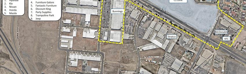
6

          (allowing 18% escape spending) then the total to be accommodated is 774,100
          sqm.
     •    This is an increase of +628,400 sqm of retail floorspace over and above Melton’s
          existing supply of 145,700 sqm.
39   In my view, the assumptions are plausible and set a reasonable expectation on what
     the city should be seeking to accommodate. These are significant requirements
     resulting in approximately 15,000-18,000 sqm of new retail floorspace in the city
     each year, for the next 35 years.
40   Even under the lower forecasts by the State Government which would see Melton’s
     average annual growth rising to 10,000 people per annum, a net increase of 15,000-
     18,000 sqm (or at least 1.5 sqm per capita) would be a minimum average annual retail
     floorspace requirement for the region.
41   It is often the case in outer growth areas where new housing areas are occurring on
     different growth fronts – as it is in Melton – that new retail supply often lags
     demand. With a dispersed growth pattern, established centres with further capacity
     to expand often take up the demands where they can efficiently service the new
     areas, until such a time as the new areas have critical population thresholds to
     support new centres.

     Scope for New Centres
42   Table 10 of the MRACS (Background Report) seeks to allocate the 774,100 sqm of
     additional retail floorspace to regional, sub-regional, neighbourhood and other
     centres in the hierarchy. It allocates a proportion of floorspace to each level in the
     hierarchy and calculates the number of centres needed based on an average
     floorspace per centre.
43   At the sub-regional level (which generally correlates with ‘Activity Centres’ under the
     ‘Plan Melbourne’ centres hierarchy), the table makes the following assumptions:
     •    43% of the 774,100 sqm is allocated to sub-regional centres or 332,900 sqm.
     •    With a sub-regional centre having a typical retail floorspace of 55,000 sqm,
          Melton at full development can support a total of 6 sub-regional centres.
     •    With three existing sub-regional centres this creates the notional scope for 3
          additional sub-regional centres.
44   A similar analysis is undertaken for regional centres (2 new) and neighbourhood
     centres (25 new).
45   While I understand the calculation on new sub-regional centre requirements is a
     hypothetical estimate, the assumption of an average of 55,000 sqm per sub-regional
     centre (comprising 35,000 sqm of conventional retail space and 20,000 sqm of
     restricted retail premises) could be an over estimate as some locations will not
     deliver either or both these floorspace assumptions. In these instances, the
     floorspace could be allocated to other locations that can deliver the floorspace from
     stronger locations or a smaller average size should be assumed in the analysis which,
     in turn, would substantiate more sub-regional centres. For example:

     Amendment C171 Melton Planning Scheme—20 March 2017                          Deep End Services
7
• There are approximately 300 sub-regional or discount department store (DDS)-
based centres in Australia and approximately 85% of these are single-DDS
centres with an average retail floorspace of approximately 20,000 sqm. Centres
of this size will be more commonly found in new growth areas as the DDS market
has weakened and the industry is shifting away from the larger but smaller
number of, double-DDS centres which average about 47,000 sqm of retail
space.
• The assumption of 35,000 sqm of retail floorspace is higher than the average for
all sub-regional centres in Australia (28,000 sqm) but, more importantly, is not a
realistic planning tool for individual locations as DDS or sub-regional centres
tend to group around the 15,000-22,000 sqm range (for single-DDS centres) or
are 40,000+ for most double-DDS centres. An average of 35,000 sqm implies a
small double DDS-based centre however these are becoming increasingly
difficult to develop in new locations given the state of the DDS market. The
market is, in fact, now moving towards a higher number of smaller single DDS
centres.
• The Caroline Springs Town Centre (currently 22,000 sqm retail space) is typical
of a single DDS-based centre but may not generate strong enough commercial
interest from major retailers to achieve 35,000 sqm of shopping centre space
and almost certainly will not develop 20,000 sqm of restricted retail premises.
• Other ‘Activity Centre’ locations in the growth areas may also find that without a
second DDS or strong main road exposure to attract national large-format
retailers, that the 55,000 sqm floorspace allocations will not be achieved.
46 While Table 10 may be a useful tool to generate a high-level estimate of activity
centre needs, there should still be some flexibility to allow centres to move within
the hierarchy and to grow as the market considers the relative strengths and
weaknesses of emerging or established locations and the changing viability of
multiple major stores in one location.
Catchment analysis
47 The MRACS determines sub-regional or ‘Activity Centre’ locations by aggregating
small areas (at full development) to catchments of about 50,000 people and
confirming either an existing centre or assigning a new ‘Activity Centre’ to the area.
The MRACS Final Report (p.12) notes that while 50,000 people was adopted for
planning purposes this could vary between 35,000 and 70,000 people.
48 The map in Figure 1 is taken from the MRACS showing six residential catchments for
sub-regional centres. In Melton East, a single catchment area extending from
Taylors Hill to Burnside is shown with the Caroline Springs Town Centre as the only
sub-regional centre.
49 Five other catchments across Melton are shown for sub-regional centres (bringing
the total to 6) which corresponds with Table 10 which calculated a similar long-term
need in Melton.
Amendment C171 Melton Planning Scheme—20 March 2017 Deep End Services8
Figure 1—Sub
regional
catchments from
MRACS
Source: MRACS p.13
2.4 Activity 50 The expectations for ‘Activity Centres’ are set out in Sections 6.2 and 6.4 of the Final
Centre Report. It notes that each Activity Centre will be different in its offering and
expectations emphasis however each will generally contain:
• A sub-regional retail function with multiple supermarkets, a DDS and specialty
shops
• Community services
• Entertainment and recreation activities
• Commercial accommodation
• Office activities
• Extensive public open space
• Public transport interchange
51 I note that the criteria include a DDS in each centre. There is no requirement or
expectation that any centre should have multiple DDS. Clearly, this is a matter for
the market to determine.
Amendment C171 Melton Planning Scheme—20 March 2017 Deep End Services9
2.5 Caroline 52 In the case of Caroline Springs, the MRACS Background Report and Final Report
Springs findings make the following points:
• Caroline Springs is presently the nominated Activity Centre for East Melton and
has developed to provide a small sub-regional offering and a substantial non-
retail service.
• The Town Centre has about 22,000 sqm of retail floorspace and over 50,000
sqm of other commercial and community uses.
• Its share of retail spending (23%) is towards the lower end of the typical share for
sub-regional centres.
• Caroline Springs is central to its catchment which the Final report indicates will
be 50,000 people at full development (MRACS p.15) although I note the
Background Report (Appendix 6) indicates it will reach 63,000 people by 2031.
• Assuming future development at Burnside and Plumpton, the natural catchment
area is likely to contract to about 30,00-40,000 people.
• These developments are likely to limit the retail potential of the centre to the
provision which currently exists.
• Office development is likely to be one of the key areas for expansion at Caroline
Springs Town Centre.
2.6 Burnside 53 In relation to Burnside and its elevation from a Neighbourhood Centre to an Activity
findings
Centre, the MRACS says the following:
• The centre has 4.5 hectares of vacant land zoned Commercial 1 and 7 hectares
zoned Mixed Use adjoining the existing centre. (I note this reference is incorrect
since the recent rezoning of the two land parcels – swapping the Mixed Use and
Commercial 1 zones – now results in 7.8 hectares of vacant Commercial 1 zoned
land adjoining the centre and 4.1 hectares of Mixed Use zoned land).
• While presently designated a neighbourhood centre it has surrounding uses that
provide sub-regional services including (then) two hardware stores and a
growing large format retail precinct.
• The area of vacant Commercial 1 zoned land is large enough to accommodate a
DDS, supermarket and specialty shops.
• The new Commercial zones have done away with floorspace caps and the
owners do not need a permit for retail or office uses.
• Given the above, it is prudent to nominate Burnside as an Activity Centre and for
Council to influence the design to produce the best outcome for residents and
centre users.
54 Further strategic support in the MRACS is given to Burnside’s Activity Centre status
by the following comments:
• At full development, Burnside and Caroline Springs would share a catchment of
60,000-70,000 people which would be sufficient to support small sub-regional
facilities at each centre (that is, a single DDS, two full line supermarkets and
specialty stores) (MRACS p.16).
• A sub-regional retail facility at Burnside would also attract shoppers from the
nearer parts of Brimbank. It could also serve some people in the newly
Amendment C171 Melton Planning Scheme—20 March 2017 Deep End Services10
developing growth areas east of the Outer Metropolitan Ring Road, at least until
the Activity Centre at Plumpton was developed (Background Report p.57).
• Burnside could also host a more extensive bulky goods offering because of its
location on the Western Highway and accommodate specialist services for the
adjoining industrial areas (MRACS p.16).
55 The proposed Activity Centre Network is shown in Figure 2.
Amendment C171 Melton Planning Scheme—20 March 2017 Deep End Services11
Figure 2—MRACS
Final Proposed
Activity Centre
Network
Source: MRACS
56 Section 3 of my report expands on some of the strategic location and catchment
area arguments put forward in the MRACS relating to Burnside’s new Activity
Centre status.
Amendment C171 Melton Planning Scheme—20 March 2017 Deep End Services12
Burnside Activity Centre
3.1 Location
Regional setting
57 Burnside has unique location advantages that favourably position it for new retail
and other investment in the next ten years. Some are discussed in more detail in the
following sections but broadly, its regional setting is characterised by:
• Access to a large, established population base through the Melton East corridor
and the outer suburbs of Brimbank.
• Western Highway access to the West Growth Corridor Precinct Structure Plan
(PSP) areas which are in final stages of planning or formative stages of
development in the case of Rockbank and Rockbank North. The four PSPs west
of Caroline Springs and adjacent to the highway, have a long-term capacity of
87,500 people – a population much larger than the East Melton corridor today.
• An emerging large format retail, showroom and commercial area along Ballarat
Road which has seen significant growth in the last five years.
• Proximity to the vast West Industrial Node which already extends north along
Robinsons Road to Burnside with a growing employment base in the industrial
and business parks through Ravenhall.
• Exposure to a major highway with 44,000 vehicles per day, close connections to
the Western Ring Road and Western By-pass and the future development of
Westwood Drive creating a second arterial past the site.
• Its position as the closest activity centre to the new Caroline Springs railway
station.
• Limited growth and development of other major activity centres which are
constrained by location, site features or demographic changes.
Amendment C171 Melton Planning Scheme—20 March 2017 Deep End Services13
Figure 3—Regional location
Regional population growth
58 The City of Melton (2015 population 132,752) is the fourth fastest growing outer
municipality of Melbourne. Melton’s average annual population growth of 5,200
people in the last five years ranks it below Wyndham (10,920 per annum), Whittlesea
(8,537) and Casey (7,550).
59 Population projections by the State Government (Victoria in Future 2016) however
indicate that Melton will gradually increase its annual growth rate to almost 8,000
new residents per annum by 2021 and to 10,000 per annum by 2031. In 2031,
Melton’s population would reach 266,000 – approximately double the 2015
population level.
60 According to the State Government’s forecasts, Melton will surpass Whittlesea’s
average annual population increase in 2021 and exceed Casey and Wyndham’s
annual growth after 2026.
Amendment C171 Melton Planning Scheme—20 March 2017 Deep End Services14
61 Burnside is well-positioned to the existing population and future growth. The
original Melton East Strategy Plan area, (refer Figure 3) broadly defined as the
corridor between Burnside and Caroline Springs in the south up to Hillside in the
north, has developed since the mid 1990’s. Originally planned for between 60,000
and 82,000 people, the area had an estimated 2016 population of almost 70,000
people and should peak at just over 75,000 people.
62 The narrow Taylors Hill West PSP area which was annexed to East Melton and
commenced in 2012 is about 80% developed towards its expected capacity of 2,400
lots or 7,000 – 7,500 people.
63 Within the broad East Melton corridor, the MRACS defined a smaller sub-regional
centre catchment area (refer Figure 4) from Taylors Hill down to Burnside where the
population has grown from 22,528 to 48,379 in the last 10 years (refer Table 1). The
main area of infill housing is the Modeina estate at Burnside off Westwood Drive
where approximately 200 homes have been built or are under construction of the
850 lot capacity.
64 The Modeina Estate, other infill housing and higher density development around
Caroline Springs Town Centre is likely to increase the population of the East Melton
sub-regional catchment to 52,700 in 2021 and about 56,260 at full capacity (refer
Table 1).
65 South east of Burnside, the new suburb of Derrimut and areas of Deer Park south of
Ballarat Rd – both in the City of Brimbank - have more than doubled in the last 10
years to about 22,000 people in 2016 (refer Table 1). Derrimut is now almost fully
developed although its population will continue to grow as young families increase
in size.
66 The vast West Growth Corridor Plan area has two approved PSPs and two in
progress close to Melton East. There are four PSPs (Mt Atkinson, Kororoit,
Rockbank North and Rockbank) abutting the Western Highway, generally within 5-
10 km of Burnside with a capacity of 87,500 people. Mirvac is developing its largest
housing estate in Australia at Rockbank North where several hundred homes are
either built or under construction. The Mirvac estate has a capacity of 7,000 lots (or
20,000 people) which is most of the North Rockbank PSP capacity.
67 In the Rockbank PSP south of Western Highway, major estates known as Thornhill
Park and Bridgefield are now selling lots with the first houses yet to be built.
68 As the Melton East area approaches full development, the West Corridor PSPs will
escalate their land release and population growth. It will be at least five years before
the first supermarket is developed in these areas and many more before major
discount department stores or similar retailers can be supported. Until then, centres
such as Burnside which is a short drive along the highway can serve a valuable role in
providing higher level retailing to the new areas.
69 The current and future population levels of the three established urban areas defined
around Burnside and the nearest PSPs to the west are shown in Table 1.
Amendment C171 Melton Planning Scheme—20 March 2017 Deep End Services15
Table 1—Population Population
growth 2006 2011 2016 2021 Capacity
Established areas
Melton East* 22,528 40,651 48,379 52,696 56,260
Derrimut-Deer Park 9,232 18,187 22,037 24,537 25,000
Brimbank Central 23,883 27,391 29,472 31,222 31,500
Total Established areas 55,643 86,229 99,888 108,455 112,760
PSP areas
Rockbank - 1,081 1,032 2,370 22,200
Rockbank North - 36 239 5,725 20,400
Mt Atkinson - - - - 19,000
Kororoit - part - 100 100 342 22,430
Taylors Hill West - part - 0 4,850 5,880 5,880
Total PSP areas 0 1,217 6,221 14,317 89,910
Total 55,643 87,446 106,109 122,772 202,670
* MR&ACS-defined area which includes part Taylors Hill West and part Kororoit
Source: ABS, PSPs, id., UDP
Figure 4—Population areas
Amendment C171 Melton Planning Scheme—20 March 2017 Deep End Services16
Regional roads connections & traffic volumes
70 Burnside has excellent access and exposure to an evolving road and rail network in
the outer west.
71 The vacant Commercial 1 zoned land has a 400 metre frontage to Ballarat Road and
200 metres to Westwood Drive. The centre is close to the Western Freeway (1.5 km)
and Western Ring Road (3.8 km) interchanges. These are important linkages which
bring significant volumes of through and passing traffic to the area and are
important factors for retailers considering the potential of the site.
Figure 5—Regional road connections
72 The high visibility and main road attributes are like some of the early and most
successful discount department store-based centres in Melbourne and Geelong -
such as the Coles and Kmart centres at East Burwood, Campbellfield and Belmont.
These have proven to be resilient centres over almost 50 years despite substantial
changes in competition, technology and population shifts.
Amendment C171 Melton Planning Scheme—20 March 2017 Deep End Services17
73 Data from Vic Roads (refer Figure 6) shows average 24-hour two-way traffic volumes
on Ballarat Road (Western Highway) passing the Burnside site was 44,000 vehicles
per day (vpd) in 2015.
74 These volumes contrast with about 30,000 vpd on Station Road passing Brimbank
Central and a similar volume (30,000 vpd) on Melton Highway near Watergardens
Town Centre.
75 Westwood Drive is planned as a future north-south arterial road through Melton
East, ultimately extending between the Calder Highway in the north and Princes
Freeway at Williams Landing in the south (refer Figure 5). When complete, it will
form a continuous 18 km 4-lane arterial and act as an alternative north-south link to
the narrow and congested Caroline Springs Boulevard where it passes through the
Caroline Springs Town Centre. To facilitate the extension, Westwood Drive will
bridge Kororoit Creek, 2 km north of Burnside.
76 Through GTA, I understand that VicRoads have modelled the future daily traffic
flows along Western Highway and Westwood Drive at 50,00 vpd each (100,000 vpd
in total).
77 The high exposure to passing and through-traffic is a key driver in the demand
analysis and commercial interest for an expanded Burnside Centre.
78 Burnside’s location at the intersection of two major arterial roads is a unique
characteristic shared by only one other centre in the western suburbs, namely
Watergardens.
79 The future extension of Rockbank Middle Rd into the West Corridor Growth area
enhances Burnside’s east-west connections into new areas.
80 The Regional Rail Link passes 1.3 km south of Burnside with its nearest station at
Deer Park. The new Caroline Springs Station on the Melton line is just 2.3 km by
road from Burnside and 4.1 km from the Caroline Springs Town Centre. Burnside is
the closest activity centre to this station.
81 Burnside will be well served by local and regional bus routes with connections to
Caroline Springs and Deer Park stations.
Amendment C171 Melton Planning Scheme—20 March 2017 Deep End Services18
Figure 6—Traffic
volumes 2015
(vehicles per day)
Source: Vic Roads
Surrounding employment growth
82 The area south of Ballarat Road, extending west to the current urban boundary of
Caroline Springs and south between the Western Freeway and Robinson Road, is
known as the Ravenhall Employment Precinct (REP) (refer Figure 7).
83 The existing 328 hectares of Commercial 2 and Industrial 3 zoned land through the
REP forms the northern end of the much larger West Industrial Node. The area
south of Burnside is characterised by retail and commercial display uses, small
office-warehouse and industrial premises and Business Parks with conventional
office buildings. Figure 7 shows land within the REP either developed or vacant,
according to the State Government’s Broadhectare Data Base in 2016.
84 In 2016, approximately 106 hectares in the REP was developed and 222 hectares (or
67%) was vacant and available for development. Since 2010, the developed land
area has increased from 61 to 106 hectares suggesting the take-up of land and
employment growth has been very strong.
85 The current employment base is difficult to estimate however at the last Census
(2011) there were 1,347 people working in the REP. Based on the growth in the area
and more intensive retail and office developments at Orbis Business Park and along
Amendment C171 Melton Planning Scheme—20 March 2017 Deep End Services19
the highway, I estimate the current employment levels in the REP to be at least
2,300 people.
86 With approximately one-third of the zoned area developed, the employment level at
full capacity in 10-15 years (at current rates of land take-up) would be close to 7,300
people. The yellow shaded areas in Figure 7 are future industrial areas of some 100
hectares that will also increase the area’s employment base.
87 For Burnside, the growing number of businesses in the REP, particularly the
associated office components, will have demands for office and business supplies
and retail and professional services which could be provided in an expanded
Burnside Activity Centre. The large and growing workforce is within walking
distance or a short drive of Burnside where a range of dine-in and take-away food,
groceries and personal services can be made available in an expanded centre.
Figure 7—
Commercial and
Industrial land
available - 2016
Source: DELW&P
3.2 Burnside 88 The Burnside Activity Centre is broadly defined by the MRACS3 to include:
activity centre
• The Burnside Hub neighbourhood shopping centre on Westwood Drive.
• McDonalds and KFC on Ballarat Road and a commercial development to the rear
off Westwood Drive.
• 7.8 hectares of vacant Commercial 1 zoned land south and west of Burnside Hub
through to Ballarat Road and 4.1 hectares of vacant Mixed Use zoned land north
of Burnside Hub.
• Large-format retail developments west of the vacant land including Bunnings,
the former Masters store and a new showroom and office development west of
Masters known as West Springs Centre.
3
MRACS Background & Analysis Discussion report, Appendix p.20
Amendment C171 Melton Planning Scheme—20 March 2017 Deep End Services20
89 These uses and areas are shown in Figure 8. I would argue that the land use and
employment functions of an ‘Activity Centre’, as they are defined under the centres
hierarchy in Plan Melbourne, are also evident in other adjoining areas of Burnside
including:
• Medium density housing to the north comprising the Burnside Retirement Village
and Westwood Aged Care Service.
• Commercial uses on the south side of Ballarat Road, generally east of Bunnings
through to Westwood Drive. This area is part of the REP and has a mix of retail,
large format retail, trade supplies, fuel and light industrial uses.
• A large format retail development on Ballarat Road, west of Bunnings. Built in
2013, the 14,387 sqm complex with 8 occupied tenancies includes national
retailers Officeworks, Petbarn, Autobarn, Furniture Galore and Fantastic
Furniture. Two leisure tenancies include a children’s play centre and café and
trampoline park.
• Further west of the large format retail strip extending to Christies Road is a
cluster of new automotive dealerships including Chrysler/Jeep/Dodge, Hyundai,
Kia, Nissan, Honda and Mazda.
Figure 8—Burnside Activity Centre – February 2017
Source: Nearmap, MRACS, Deep End Services
Amendment C171 Melton Planning Scheme—20 March 2017 Deep End Services21
90 The Ballarat Road retail and commercial strip through Burnside (on the north side)
and Ravenhall (south side) has developed rapidly since 2011. In particular:
• Bunnings and Masters hardware stores were developed in 2012. The now vacant
Masters store is likely to revert to a range of large format retail tenancies further
consolidating the area as a growing destination for national retailers.
• The large format retail centre and car dealerships on the south side and the West
Springs Centre on the north side have all developed from 2013 through to mid-
2015.
3.3 Burnside Hub 91 Burnside Hub Shopping Centre was developed in 2003 as the first supermarket-
based centre in the Melton East corridor. Other than some tenancy changes (Bi-Lo
rebadging to Coles) and a recent minor extension to ALDI, the centre itself has
remained largely unchanged since opening.
92 The centre has a mid-sized Coles supermarket (2,522 sqm), free-standing ALDI store
(1,506 sqm), 17 shops and a medical centre. The total gross leasable area is
approximately 6,284 sqm (refer Table 2).
Table 2—Burnside No. of tenants Floorspace (sqm)
Hub existing
floorspace Coles 1 2,522
ALDI 1 1,506
Specialty shops 16 1,935
Total retail 18 5,963
Medical 2 318
ATMs/Kiosks 3 3
Total centre 23 6,284
93 The centre is oriented towards Westwood Drive which currently functions as a
collector road for the Burnside housing estates. Westwood Drive terminates at the
future bridge crossing on Kororoit Creek, 2.2 km north of Burnside. The centre has
low visibility and exposure to Ballarat Road and while the specialty shop component
has been fully let and stable over many years, the centre has been constrained by its
current layout and small Coles supermarket.
3.4 Extended 94 The opportunity at Burnside, created by the favourable site attributes, regional
centre growth characteristics and the available Commercial 1 zoned land, is to develop a
large single DDS-based centre, consistent with the MRACS with the following
features:
• A centre with high convenience which is attractive to the existing catchment and
new housing areas in the West Growth Corridor.
• To re-orientate the centre away from its current perspective to Westwood Drive
towards the Western Highway with strong links to the large format retail areas
west of the vacant land.
• To secure a major DDS tenant such as Kmart whose nearest stores are at Keilor
Downs, Melton and Footscray.
• To increase the size and number of supermarkets.
Amendment C171 Melton Planning Scheme—20 March 2017 Deep End Services22
• To create a strong north-south link through to the Mixed Use zoned land and
retirement village to the north.
• To attract a range of non-retail, commercial and leisure / entertainment tenants
and uses which complement the retail function and increase the mixed-use
elements of the centre.
• Provide a relevant centre for the businesses and large and growing employment
base through Ravenhall.
3.5 Extended 95 Figure 9 shows the Caroline Springs (East Melton) sub regional catchment
MRACS reproduced from the MRACS, limited, as it was, to the residential areas within the
Catchment area City of Melton. This area is outlined in red. I also show two shaded areas being a
reduced core Caroline Springs catchment (red) and Burnside’s core local catchment
(shaded blue) which occupies part of the Melton East area and penetrates other
adjacent areas labelled Derrimut – Deer Park in Brimbank (outlined in blue). The
connections to the employment land and PSP areas are also shown.
96 These areas are not the entire catchments of each centre as major road connections
will extend Burnside’s catchment into other areas of East Melton (north of Kororoit
Creek) and further east into Brimbank (Cairnlea).
97 Table 3 shows the relative current and future population of both shaded areas
around each centre. Caroline Springs has a slightly larger population of 37,890 in
2016 compared to 32,530 people around Burnside.
98 By 2021, Burnside’s population is projected to reach 37,240 which meets the 35,000
threshold for a sub-regional centre set out in the MRACS.
99 Both centres will experience growth in their catchments – Caroline Springs from
parts of Taylors Hill West, the eastern part of the Kororoit Creek PSP and higher
density housing around the Town Centre. Burnside will grow with the Dennis Family
housing estate at Modeina (Burnside) and new and larger families growing into the
new areas of Derrimut.
Table 3— Core Adjusted catchments 2016 2021 Capacity
catchment area
populations Caroline Springs 37,890 39,990 43,460
Burnside 32,530 37,240 37,800
Total 70,420 77,230 81,260
100 Figure 9 also shows an almost straight road distance of 7.5 km from Burnside to a
point on the Western Highway where the new estates are being sold either side at
Rockbank and Rockbank North. The same relative distances from this point are
9.4km to Caroline Springs Town Centre (including via the slower Caroline Springs
Boulevard route) or 9.6 km back to Woodgrove Shopping Centre at Melton.
Amendment C171 Melton Planning Scheme—20 March 2017 Deep End Services23
Figure 9—Adjusted MRACS catchments
Amendment C171 Melton Planning Scheme—20 March 2017 Deep End Services24
3.6 The case for a 101 A DDS such as Kmart, Target or Big W is the major retail tenancy commitment that
DDS at Burnside will facilitate Burnside’s elevation to a sub-regional shopping centre.
102 Over the last five years there has been a considerable shift in the DDS market which
has had general implications for shopping centre sites looking to secure DDS
commitments. The market participants are shaping the Brimbank and East Melton
activity centres in the following ways:
• Kmart, who has been the leading DDS operator for the last 7 years with
remodelled stores, reduced merchandise lines, a new pricing model and better
marketing, closed an underperforming store at Brimbank Central in 2012.
Brimbank was a case of an established centre whose catchment, while relatively
large, was insufficient to support both the Wesfarmers’ owned Kmart and Target
brands.
• Target and Big W now have significantly reduced new store programs
considering their lower trading levels.
• Caroline Springs Square added Target to its centre in a Stage2 expansion in
2009 raising the centre to about 22,000 sqm (retail GLA). I understand Lend
Lease has plans to increase the centre to 36,000 sqm with a second DDS. In the
almost five years which have elapsed since the previous Amendment C112 Panel
Report into Burnside’s then proposed expansion, it has become evident to me
that Target is an underperforming store at Caroline Springs and Kmart and Big W
have little or no interest in pursuing a new store at the centre.
103 While the DDS operators have formed their own view about Caroline Springs, in my
opinion it has some inherent location and design weaknesses that constrain it from
achieving its desired status as a double DDS-based centre in the short-medium term.
These include:
• Its central location to Caroline Springs is desirable for a neighbourhood or large
community-sized centre however it does not command a large enough regional
catchment to support multiple large retail stores.
• The internal location 3km inboard of Ballarat Road is too far to draw people into
the site off the external main road network.
• Caroline Springs Boulevard is designed and functions as a 4-lane collector road,
not a major arterial carrying through traffic which many of the large sub-regional
centres require to access wider catchments.
• The Boulevard’s low traffic function and the lack of a strong east-west connector
road reinforce its localised catchment.
• The schools and community facilities are desirable close to the centre but create
traffic congestion in peak periods limiting the Boulevard’s carrying capacity.
104 Figure 10 shows a large functional region around Caroline Springs and Brimbank
Central with over 100,000 people and just 2 DDS - both Target. Outside this area,
the nearest DDS are a third Target store and Big W at Watergardens Town Centre
and Big W at Sunshine.
Amendment C171 Melton Planning Scheme—20 March 2017 Deep End Services25
105 Kmart has just one store in the outer west at Keilor Downs. Its next nearest stores
are well beyond the Burnside – Caroline Springs catchment at Melton, North Altona
and Footscray.
106 DDS rates of provision (population per store) vary widely across Melbourne. While
metropolitan-wide rates pf provision are in the order of one store per 45,000-50,000
people, rates in outer areas are much higher (that is, lower populations per store)
where there are more opportunities for large-format stores and where household
characteristics and spending patterns are more inclined to DDS shopping. Figure 10
shows notional DDS catchments around groups of centres in the outer west.
107 Although boundaries between or around groups of centres are subject to
interpretation, it is evident to me that:
• The discrete outer areas of Melton and Point Cook have one DDS per 30,000
people on current population levels. Point Cook has all three DDS brands in
close proximity.
• The balance of Wyndham has three DDS and one under construction (Kmart)
which is one per 38,500 people. A potential DDS commitment at Wyndham
Vale could drop the rate of provision to one per 34,000 by 2018.
• Sydenham – Keilor has three DDS (all brands) with one per 32,830 people.
• An area covering Caroline Springs Square, Brimbank Central and Burnside with
107,000 people has just two Target stores – or one DDS per 53,500 people.
• Even if the Sydenham - East Keilor and Caroline Springs – Brimbank catchments
were combined, the effective rate of provision is still lower than the other areas
at one per 41,100 people.
• In the Sydenham-Keilor-Brimbank-Melton East area, not only is the rate of
provision low but three of the five DDS are Target stores which is arguably the
worst performing DDS brand in the market.
• Importantly, across all the centres in the outer west, the only locations with 2 or
more DDS are the strong-performing centrally located activity centres on major
arterials roads including Watergardens, Pacific Werribee and Woodgrove.
108 Caroline Springs Square which has sought to attract a second DDS would be one of
only four centres in the outer west with 2 DDS. Its embedded location and local
road connections make it a poor comparison against the much stronger and larger
double DDS centres in the region that it seeks to emulate.
Amendment C171 Melton Planning Scheme—20 March 2017 Deep End Services26
Figure 10—DDS provision outer west
Source: Deep End Services
3.7 Burnside 109 On the available information and my inspection of the area, Burnside can meet the
meeting the role and expectations of an Activity Centre, as set out in the MRACS (p.12). It can
expectations for provide a broad range of jobs and services to a substantial catchment comprising a
Activity Centres suburb or several suburbs and can generate a large number of trips for retail,
entertainment, community and business purposes.
110 As the NRACS indicates, not all Activity Centres are alike. Some, like Caroline
Springs, have an embedded residential setting and a high quality, master-planned
built environment with well-arranged retail, community, office and other uses.
Other planned Activity Centres at Plumpton, Rockbank and North Rockbank will
probably develop in a similar way.
Amendment C171 Melton Planning Scheme—20 March 2017 Deep End Services27
111 Burnside on the other hand, is emerging from a disparate group of uses including a
small neighbourhood centre, a retirement village, restricted retail premises and
other commercial and light industrial uses along a major arterial road. These uses
can now be integrated and linked via the large areas of Commercial 1 and Mixed Use
zoned land. Burnside will have a harder physical appearance but will nonetheless be
a strong contributor to jobs and services on the Melton – Brimbank boundary. This
role could be similar to the future Hopkins Road Activity Centre at Mt Atkinson
which has a smaller planned population base relative to other centres but is intended
to service a significant industrial and commercial area.
112 On the specific expectations of Activity Centres, Burnside has or should contain:
• A sub-regional retail function including a DDS, multiple supermarkets and an
important cluster of restricted retail premises.
• A range of community services such as allied health and medical services.
• Entertainment and recreation activities including cafes and restaurants. The
surrounding commercial and industrial areas already have a range of leisure-
based businesses including a swimming school, indoor play centres and
trampoline park.
• Commercial offices in and around the retail centre and along Ballarat Road.
• Linkages to the Kororoit Creek walking trail and linear open space system.
• Bus services to the surrounding area and the nearest stations at Deer Park and
Caroline Springs.
113 On the important employment criteria, Burnside is now at the centre of a growing
commercial and industrial area through Ravenhall with about 2,300 jobs. This area is
just one-third developed with a strong take-up of industrial and business land. These
areas will have growing need for office support and business services, food and
restaurants, medical services and other retail businesses that can be frequented by
employees to or from work.
114 The core catchment population of Burnside will be at least 35,000 people meeting
the minimum threshold set out in the MRACS. The catchment will be effectively
much larger based on the surrounding workforce, the Ballarat Road and future
Westwood Drive arterial road intersection and the potential to reach the growing
areas on the West Growth Corridor.
115 Burnside’s retail floorspace could well start as a large single-DDS sub regional centre
of up to 25,000 sqm growing with subsequent stages to the 35,000 sqm indicative
floor area.
116 Outside the Commercial 1 zoned land, the Ballarat Road strip will become
increasingly popular for restricted retail uses as the Masters store converts to
smaller premises and other national retailers become aware of the area’s favourable
access and regional catchment.
Amendment C171 Melton Planning Scheme—20 March 2017 Deep End Services28
Activity centres hierarchy
4.1 Melton East 117 Until the release of the MRACS, activity centre planning has progressed based on
Structure Plan the 1997 Melton East Structure Plan (MESP) – now 20 years old.
Activity Centre 118 The plan recommended an activity centre network with 63,000 sqm of retail
Framework (1997)
floorspace for the (then estimated) 62,000 people - a very low provision of less than
1 sqm per capita which retained just 52% of floorspace demands in the area. This is a
very low rate as current-day expectations of floorspace provision have changed.
119 The low floorspace provision is now incompatible with Council’s community
feedback on the need for a wider range of services at centres and Council’s
expectations that activity centres make higher contributions to employment
generation.
120 Other factors which render the activity centre recommendations of the MESP
redundant are that:
• Actual population levels in the MESP area are likely to be at the top end of the
60,000 - 80,000 population range which was estimated for planning purposes.
• The West Corridor Growth Plan and the PSP areas now planned and developing
west of Burnside and Caroline Springs, were not contemplated in 1997.
• Two of the five ‘neighbourhood centres’ have not developed due to proximity to
larger centres while a third was relocated and reduced in size.
• Two of the three ‘Community Centres’ (Burnside & Taylors Hill) have been
developed while the Banchory Grove site, acquired by QIC (owners of
Watergardens), has been held for over 15 years undeveloped.
121 The Indicative Activity Centre Framework from the 1997 MESP is shown in Figure 11
with commentary on the various locations.
Amendment C171 Melton Planning Scheme—20 March 2017 Deep End ServicesYou can also read