PLAN OF MANAGEMENT Mallanganee Memorial Park (Sportsground) - Kyogle Council
←
→
Page content transcription
If your browser does not render page correctly, please read the page content below
Mallanganee Memorial Park
(Sportsground)
PLAN OF MANAGEMENT

                       July 2020 | Version 2.0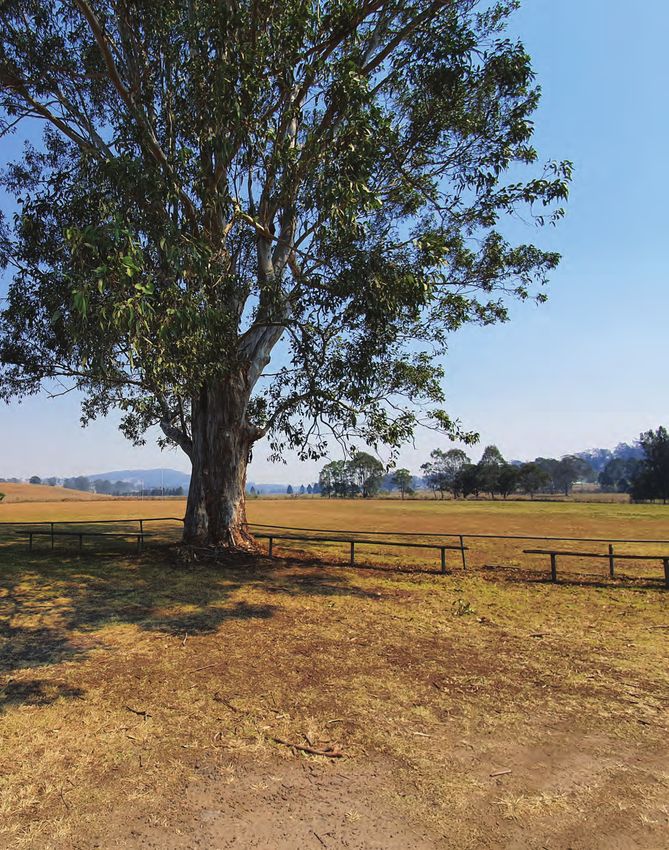
Prepared by                                        Acknowledgments
                   ROSS Planning on behalf of                         Kyogle Council acknowledges the Australian Aboriginal and
                                                                      Torres Strait Islander peoples of this nation. It acknowledges the
                   © Kyogle Council                                   traditional custodians of the lands on which it operates and pays
                                                                      its respects to Elders past and present.
                   1 Stratheden Street
                   KYOGLE NSW 2474

                   www.kyogle.nsw.gov.au

Disclaimer                                                            Version Control
Any representation, statement, opinion or advice expressed or
                                                                      Version   Release / Issue             Date
implied in this Plan of Management is made in good faith. While
every reasonable effort has been made to ensure the accuracy of       1.0       Preliminary Draft           January 2020
the Plan at the time of publication, Kyogle Council, its agents and
                                                                      2.0       Final                       July 2020
its employees, disclaim any and all liability (whether by reason of
negligence, lack of care or otherwise) to any person in respect of
anything done or omitted to be done in reliance upon the whole
or any part of this publication.

Copyright Notice

Copyright, including all intellectual property, vests in Kyogle
Council.

Council agrees to the reproduction of extracts of original material
that appears in this publication for personal, non-commercial
use or for professional research or report production purposes,
without formal permission or charge. All other rights reserved.

If you wish to reproduce, alter, store or transmit material
appearing in this publication for any other purpose, prior
permission must be obtained in writing from Kyogle Council.
CONTENTS

1.0     Key information........................................................................4         4.0    The Plan of Management......................................................17

2.0     Introduction.............................................................................. 5            4.1     Aims of the Plan of Management..................................17
        2.1      Community Land and Plans of Management................5                                        4.2     Core objectives of this Plan of Management............17
    2.1.1    Classification of public land..................................... 5                               4.3     Use and Development of Community Land at ..............
    2.1.2		  Community Land........................................................... 5                 			            Mallanganee Park................................................................17
    2.1.3		  Category of Community Land .................................. 5                             		 4.3.1		           Zoning.............................................................................17
    2.1.4    Plans of Management for Community Land....... 5                                             		 4.3.2		           Development allowed in RU1 Primary ...................
    2.1.5    Specific Plans of Management................................ 5
                                                                                                         					                Production zone..........................................................17
    2.1.6		  Legislation pertaining
                                                                                                         		 4.3.3		           Permissible uses and developments...................18
   				      to this Plan of Management........................... .6
    2.1.7		  Council documents ..................................................... 8                   		 4.3.4		           Leases, licences and other estates.......................19
  2.2 Process of preparing this                                                                                 4.4     Management objectives and actions for ........................
			      Plan of Management............................................................ 8                			            Mallanganee Park................................................................20
  2.3 Change and review of Plan of Management............... 8                                                  4.5     Objectives and performance targets............................21

3.0     The Context............................................................................ 11       APPENDICES...............................................................24
        3.1 The residents of Mallanganee........................................11
          3.1.1   Community profile - key facts and trends...........11
          3.1.2		 Implications for open space...................................11
        3.2		Community Land in Mallanganee.................................11
          3.2.1		 Open space in Mallanganee...................................11
          3.2.2		 Parks near Mallanganee Park ................................11
        3.3 Description of Mallanganee Park..................................13
          3.3.1		 Location and context of Mallanganee Park.......13
          3.3.2		 Key features and landscape character................14
          3.3.3		 Key stakeholders.........................................................14
          3.3.4		 Consultation summary..............................................14
          3.3.5		 Leases/licences............................................................14
          3.3.6		 Land use and current improvements..................14
          3.3.7		 Infrastructure and embellishments.....................14
          3.3.8   Access, circulation and parking.............................15
          3.3.9		 Lighting..........................................................................15
          3.3.10 Play equipment...........................................................15
          3.3.11 Toilets and park furniture........................................15
          3.3.12 Stormwater and drainage........................................15
          3.3.13 Buildings........................................................................15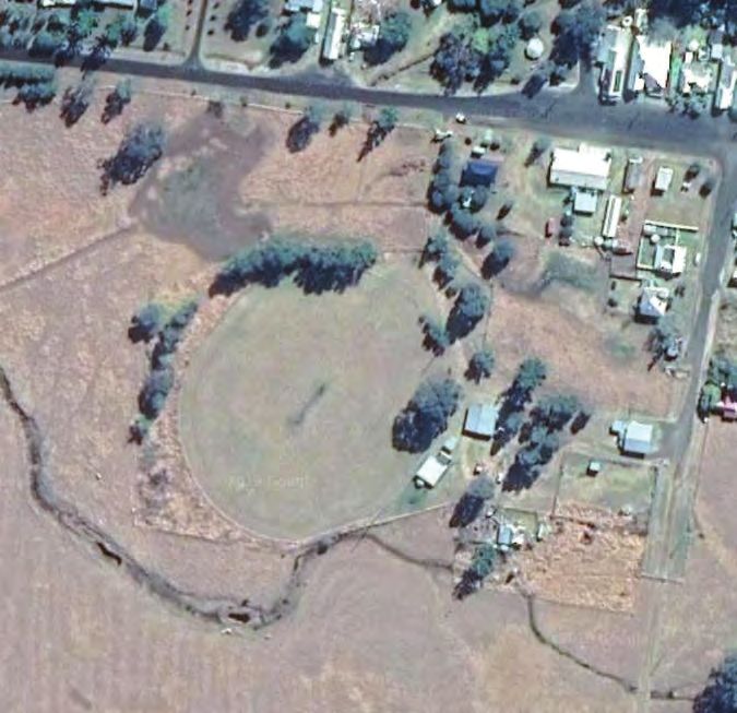
INTRODUCTION

                                                            1.0 KEY INFORMATION
                                                             Plan of Management for:         Mallanganee Sportsground
                                                             Local Government:               Kyogle Council
                                                             Land tenure                     Community land (Council)
                                                             Size of Reserve:                2.12 hectares
                                                             Date of adoption:               14 December 2020
Mallanganee Sportsground - P L A N O F M A N AG E M E N T

                                                                                                                                              NORTH

                                                                                                                                              Not to scale

                                                            Figure 1: Aerial image of Mallanganee Sportsground showing site boundary extent
                      4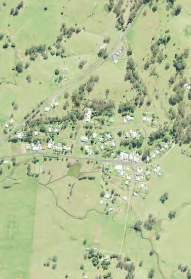
2.0 INTRODUCTION                                                     2.1.4		Plans of Management for Community Land
                                                                     The Local Government Act 1993 requires all councils to prepare
2.1 Community Land and Plans of Management                           Plans of Management (POMs) to govern the use and management
                                                                     of all community land owned or under their care, control and
2.1.1 Classification of public land                                  management.
The Local Government Act 1993 (NSW) (LG Act) requires                Councils may not undertake any activities, uses or developments
classification of public land into either community or operational   that are not provided for in POMs. Any changes to POMs must be
and the land is managed in accordance with the legislation.          publicly exhibited in accordance with the Local Government Act.
This Plan of Management (POM) applies to Mallanganee Memorial        Section 36 of the LG Act sets out the requirements for a POM that
Park (commonly referred to as Mallanganee Sportsground) located      are summarised below.
in the Village of Mallanganee within the Kyogle Local Government
Area (LGA). Mallanganee is located in the southern part of the       A Plan of Management for community land must identify the
municipality.                                                        following:

A total area of 2.12 hectares of public reserve is covered under     • the category of the land
this Plan. Refer to Figure 1.                                        • the objectives and performance targets of the Plan, with respect
                                                                        to the land
Currently, the park is covered by Council’s Generic Plan of          • the means by which the council proposes to achieve the Plan’s
Management, however, the location, features and community               objectives and performance targets
priorities warrant a specific Plan of Management.
                                                                     • the manner in which the Council proposes to assess its
Mallanganee Park is owned and managed by Kyogle Council for             performance, with respect to the Plan’s objectives and
public use. The park has a range of values, including recreation,       performance targets.
sport and camping.                                                   A POM that applies to one area of community land must also
                                                                     include a description of the:
A Plan of Management (POM) is required to ensure the values of
the land are protected, that the use of the reserve meets a range    • condition of the land, and any buildings or other improvements
of community needs and that appropriate management actions             on the land, as at the date of adoption of the Plan of
are identified and implemented.                                        Management
                                                                     • use of the land and any such buildings and improvements, as at
The reserve is adjacent to Council-owned operational land, as well     that date
as privately owned rural and residential properties.                 • purposes of which the land, and any such buildings or
                                                                       improvements, will be permitted to be used
This POM has been prepared in accordance with requirements of
the Local Government Act 1993. The Act requires that all community   • purposes for which any further development of the land will be
land be subject to a POM. The Act also requires the management         permitted, whether under lease or licence or otherwise
objectives specified for community land be included in the POM.      • scale and intensity of any such use or development.
                                                                     2.1.5 Specific Plans of Management
2.1.2 Community Land
                                                                     Council’s Community Land Generic Plan of Management states
Open space community land (generally known as parks, reserves        that some open spaces need specific POMs to be prepared for
and sportsgrounds) is land owned or controlled by councils           reasons, such as substantial size, large number and variety of uses,
and other government entities and recognised as an important         and community concern about particular sites.
element of the urban environment, providing opportunities
for recreation. Under the Local Government Act, there are five       The Local Government Act also requires specific POMs for
categories of community land comprising:                             community land included in this list:
• park                                                               • land declared to be critical habitat under the Fisheries
• sportsground                                                          Management Act 1994
• general community use                                              • land subject to threat abatement plan prepared by the Office
• cultural significance                                                 of Environment and Heritage (OEH) under the Fisheries
                                                                        Management Act 1994 for key threatening processes
• natural area.
                                                                     • land subject to recovery plans prepared by OEH under the
Land that is categorised as a natural area requires further             Fisheries Management Act 1994
categorisation as one or more of the following:                      • land declared by Council to contain significant natural features
•   bushland                                                         • land declared by Council to contain an area of cultural
                                                                        significance.
•   wetland
•   escarpment                                                       This POM for Mallanganee Memorial Park is a specific POM. The
                                                                     area requires its own specific POM because has substantial size
•   watercourse                                                      and significance, relative to the Village.
•   foreshore
                                                                                                                                            Mallanganee Sports Ground - P L A N O F M A N AG E M E N T

•   a category prescribed by the regulations.

2.1.3 Mallanganee Park Community Land category
Mallanganee Park is categorised as General Community Use.

.

                                                                                                                                                            5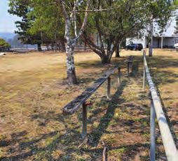
2.1.6		Legislation pertaining to this Plan of Management
                                                            Mallanganee Memorial Park is located within the Kyogle Council LGA and is owned and managed by Kyogle Council.

                                                            Council’s management responsibilities for the park are framed by the NSW Local Government Act 1993 (LG Act) and the Environmental
                                                            Planning and Assessment Act 1979 (EP&A Act) and amendments.

                                                            The LG Act provides the management framework and processes for the land, while the EP&A Act and related planning instruments and
                                                            policies control the use and development of the land.

                                                            Plans of Management for public land must be prepared in accordance with the statutory requirements of the Local Government Act.

                                                            Use and management of parks and reserves must comply with all applicable planning controls under the Environmental Planning and
                                                            Assessment Act, namely the Kyogle Local Environmental Plan (LEP) 2012.

                                                            Local Government Act 1993
                                                            The Plan of Management is a statutory document that sets out for the community how Kyogle Council plans to manage Mallanganee
                                                            Memorial Park, into the future. Division 2 of the Local Government Act requires Council to prepare a Plan of Management for community
                                                            land and to use and manage that land only in accordance with that plan. The LG Act also requires that a Plan of Management must
                                                            identify the objectives, performance targets and permissible uses for community land. Table 1 indicates how this POM incorporates the
                                                            requirements of the LG Act.
                                                            Table 1.   Plan of Management requirements under the Local Government Act 1993

                                                             Requirements of the Local Government Act 1993                                                                        Reference in this Plan of
                                                                                                                                                                                  Management

                                                             A description of the condition of the land, and of any buildings or other improvements on the land, as at the date   Section 3.3
                                                             of adoptions of the Plan of Management

                                                             A description of the use of the land and any such buildings or improvements, as at the date of adoption of the       Section 3.3
                                                             Plan of Management

                                                             Categorisation of community land                                                                                     Section 2.1

                                                             Core objectives for management of the land                                                                           Section 4.2

                                                             The purposes for which the land, and any such buildings or improvements, will be permitted to be used                Section 4.3.3

                                                             The purposes for which any further development of the land will be permitted, whether under lease or licence or      Section 4.3.3
                                                             otherwise

                                                             A description of the scale and intensity of any such permitted use or development                                    Section 4.3.3

                                                             Authorisation of leases, licences or other estates over community land                                               Section 4.3.4

                                                             Performance targets                                                                                                  Section 4.4

                                                             A means for assessing achievement of objectives and performance targets                                              Section 4.4

                                                            Local Environmental Plan 2012
                                                            The Kyogle Local Environmental Plan 2012 (LEP) is a statutory instrument prepared in accordance with the Environmental Planning and
                                                            Assessment Act 1979 to set out development objectives and consent requirements for particular areas. Under the LEP, the land parcels
                                                            making up Mallanganee Memorial Park are zoned RU1 Primary Production.

                                                            The objectives of the RU1 zone are to:
                                                            • encourage sustainable primary industry production by maintaining and enhancing the natural resource base
                                                            • encourage diversity in primary industry enterprises and systems appropriate for the area
                                                            • minimise the fragmentation and alienation of resource lands
                                                            • minimise conflict between land uses within this zone and land uses within adjoining zones
                                                            • ensure that the productive capacity of agricultural land is appropriately recognised and managed
                                                            • enable a range of other uses to occur on rural land providing such uses do not conflict with existing or potential agriculture and do
                                                              not detract from the scenic amenity and character of the rural environment.
Mallanganee Sportsground - P L A N O F M A N AG E M E N T

                                                            Consent is not required for activities, including environmental protection works, extensive agriculture, home-based child care, home
                                                            occupations and intensive plant agriculture.

                                                            The following activities are permitted with the consent of Council in the RU1 zone:
                                                            Airstrips, animal boarding or training establishments, aquaculture, bed and breakfast accommodation, boat sheds, building identification
                                                            signs, business identification signs, camping grounds, caravan parks, cellar door premises, cemeteries, charter and tourism boating
                                                            facilities, community facilities, crematoria, dual occupancies, dwelling houses, ecotourist facilities, educational establishments,
                                                            environmental facilities, extractive industries, farm buildings, farm-stay accommodation, flood mitigation works, forestry, function
                                                            centres, helipads, home businesses, home industries, industrial training facilities, information and education facilities, intensive livestock
                                                            agriculture, open-cut mining, plant nurseries, recreation areas, recreation facilities (outdoor), restaurants and cafes, roads, roadside stalls,
                                                            rural industries, rural supplies, rural workers’ dwellings, secondary dwellings, timber yards, turf farming, veterinary hospitals, water-
                                                            supply systems.
                                                            While an extensive range of uses is permitted in the zone, this POM identifies a reduced range of uses considered suitable for the
                                                            reserve.
                      6
N at ive T itl e co n s id e r a t i o n s
Council has an appointed Native Title Manager (NTM) who is responsible for providing advice to Council in connection with its Native
Title obligations. The NTM has advised that the Plan of Management was validated against subdivision S24JA of the Native Title Act
1993, and that copies of the Plan of Management were provided to NTSCORP Limited as part of the consultation process. The NTM
advised that there were no objections raised to the Plan of Management.

The NTM advises that any disturbance of ground within the nominated footprint included in the adopted Plan of Management does not
require any further Native Title notification. However, any disturbance of ground outside the nominated footprint will require further
Native Title notification. Advice is to be sought from Council’s NTM for any proposed future acts.

Other relevant legislation and statutory controls
Under section 35 of the LG Act, community land is required to be used and managed in accordance with a Plan of Management and
any law permitting the use of the land for a specific purpose. Table 2 summarises the legislation (other than the LG Act) that applies, or
potentially may apply, to management and use of Mallanganee Park.

Table 2.   Legislation that may be applicable to Mallanganee Park

 Legislation                                 Application to Mallanganee Park

 Environmental Planning and                  This Act provides environmental planning instruments for development control at the state (State Environmental
 Assessment Act 1993 (NSW)                   Planning Policies), regional (Regional Environmental Plans) and local (LEPs) levels. While this Plan of
                                             Management determines permitted uses in Mallanganee Park, specific activity or development will require
                                             assessments through the development application (DA) process under relevant sections of this Act. Where a
                                             proposal is likely to have a significant impact on the environment, an environmental impact assessment (EIA)
                                             must be conducted under the Act. The DA and EIA processes consider and provide the public with information on
                                             the environmental, social, cultural and economic impacts of the proposed activity or development and enable
                                             members of the public to comment on the proposal.

 Native Title Act 1993                       The Native Title Act 1993 recognises the rights and interests of Aboriginal and Torres Strait Islander people in
 (Commonwealth)                              land and waters according to their traditional laws and customs. The Act establishes a process for claiming and
                                             recognising Native Title lands and waters in Australia. The NTA aims to balance Indigenous and non-Indigenous
                                             peoples’ rights to land, and sets out how Native Title rights and interests fit within Australian law.

 Aboriginal Land Rights Act 1983             Under the Aboriginal Land Rights Act 1983 (ALRA) in NSW, Aboriginal Land Councils can claim land as
 (NSW)                                       compensation for historic dispossession of land and to support Aboriginal communities’ social and economic
                                             development. The ALRA recognises the traditional ownership and occupation of the land by Aboriginal peoples
                                             and the importance of their connection to land. The ALRA recognises the spiritual, cultural and economic
                                             importance of land to the state’s Aboriginal peoples.

 National Parks and Wildlife Act             Under this Act, it is an offence to knowingly disturb an Aboriginal object or site without a consent permit issued
 1974 (NSW)                                  by the Office of Environment and Heritage (OEH). Traditional Aboriginal cultural activities, conservation works and
                                             emergency activities are exempt from this provision.

 Heritage Act 1977 (NSW)                     This Act cover the protection and management of non-Aboriginal heritage. It provides for listing of significant
                                             sites on the State Heritage Register or under Local Environmental Plans.

 Biodiversity Conservation Act 2016          Commenced in August 2017, this Act provides for the management of biodiversity conservation and native
 (NSW)                                       vegetation, including through a Biodiversity Offsets Scheme, declaration of Areas of Outstanding Biodiversity
                                             Value and protection of threatened species. It provides for the listing and protection of flora and fauna species
                                             and ecological communities, as well as the management of threatening processes.

 Environment Protection and                  This Commonwealth legislation provides for the protection of nationally significant threatened species and
 Biodiversity Conservation Act 1999          cultural heritage.
 (Commonwealth)

 Biosecurity Act 2015 (NSW)                  This Act provides for the management of animal and plant pests, diseases and contaminants that threaten the
                                             environment, biodiversity, the economy and the community.

 Rural Fires Act 1997 (NSW)                  Under section 63 of this Act public authorities have a duty to take steps to prevent the occurrence of bushfires on
                                             their land and minimise the danger of the spread of bushfires from that land.
                                                                                                                                                                   Mallanganee Sports Ground - P L A N O F M A N AG E M E N T

                                                                                                                                                                                    7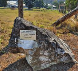
2.1.7 Council documents
                                                            Relevant Council strategic planning and policy documents were reviewed to inform development of this Plan of Management and are
                                                            summarised here.

                                                            Kyo g le Co mmu n ity St r a tegi c P l a n - P l a n n i n g fo r Gr owth
                                                            The plan highlights the opportunities available in the Kyogle Local Government Area (LGA) for growth and investment, as an established
                                                            agricultural and lifestyle locale. The Plan provides a range of cues that address priority themes to enhance liveability and sustainability
                                                            of the area, while maintaining a contemporary position, commensurate with growth and emerging opportunities in other regions. These
                                                            themes were identified through broad community consultation and focus groups.

                                                            Kyo g le E co n o mic D eve l o p m e n t F ut ur e - Pa t h w a ys to Pr osper i ty
                                                            Council is identifying and implementing a range of strategies to encourage development of a broad range of industries, particularly
                                                            those that generate high employment, to strengthen the economic base for the area. The amenity and attractiveness of places are
                                                            directly connected to key growth indicators and can contribute to population growth, business investment and higher property prices.
                                                            Place-based economic development is the practice of using a community’s public spaces to contribute to economic progress.

                                                            This approach focuses on identifying and leveraging the unique characteristics of places and existing assets to attract investment and
                                                            strengthen existing businesses.
                                                            Vision s of V il l a g e Li fe M a s te r P l a n
                                                            In consultation and collaboration with Village communities across the municipality, Council developed Village Master Plans setting
                                                            out the vision, goals and priorities for each locality to guide planning, project delivery and decision making, as well as specific projects,
                                                            actions and initiatives Council will deliver to support achievement of Village vision statements.

                                                            Relevant information contained in the Mallanganee Village Master Plan has been included in this Plan of Management and used as
                                                            basis for further community engagement and consultation. The Village vision is:

                                                                  For Mallanganee to remain a beautiful, quiet, small village where people can enjoy nature, wildlife and the country town atmosphere.

                                                            Kyo g le a n d V il l a g es O pe n Sp a ce D e s i gn G ui d e
                                                            The Open Space Design Guide was established to provide a framework to guide the delivery and ongoing maintenance of infrastructure
                                                            within a range of public open spaces and reserves across the Kyogle Local Government Area (LGA). The guide includes a series of
                                                            guiding principles and processes, which have been established from emerging and best practices in urban design. The guide also
                                                            identifies and applies best practice approaches to place making in a regional and rural context by providing advice on the character,
                                                            design, appointment and activation of key public spaces to reflect an established place character and community identity.

                                                            The Guide provides a locally relevant categorisation of open spaces to inform future planning, engagement and activation processes by
                                                            Council. It prescribes infrastructure requirements for open space materials, finishes and forms, addresses the maintenance requirements
                                                            associated with such items, and considers the suitability of materials in the context of the prevailing climatic conditions in the region.

                                                            2.2 Process of preparing this Plan of Management
                                                            The process of preparing this Plan of Management is depicted in this flowchart.

                                                             >                >                >                >             >               >             >                >             >
                                                             Initial          Prepare draft    Notify land      Council       Public          Report to     Preparation of   Adoption by   Prepare a Works
                                                             stakeholder      POM with         owner            resolution    exhibition      Council       final POM        Council       Plan with
                                                             consultation     Native Title                      to publicly                   discussing                                   short, medium
                                                                              Manager                           exhibit the                   submissions                                  and long-term
                                                                              advice                            POM                                                                        actions to guide
                                                                                                                                                                                           implementation
                                                                                                                                                                                           of the POM

                                                            2.3       Change and review of this Plan of Management
                                                            Plans of Management require periodic review in order to align with community values and changing community needs and to reflect
                                                            changes in Council priorities. This POM will be reviewed regularly to ensure that the document reflects current uses, management
                                                            objectives and performance targets.

                                                            The Plan of Management for Mallanganee Park will be reviewed by 30 June 2024 and every four years, thereafter.
Mallanganee Sportsground - P L A N O F M A N AG E M E N T

                      8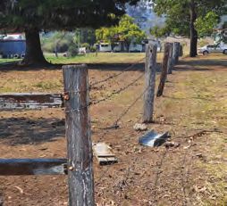
This page has been left blank intentionally.

9
    Mallanganee Sports Ground - P L A N O F M A N AG E M E N T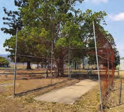
THE CONTEXT

Figure 2: Mallanganee Memorial Park entry and adjacent playground
3.0 THE CONTEXT
3.1 The residents of Mallanganee                                             3.2 Community Land in Mallanganee

3.1.1 Community profile - key facts and trends                               3.2.1 Open space in Mallanganee
Approximately 148 people lived in Mallanganee at the last                    Kyogle’s Open Space Design Guide details several park typologies
Census collected in 2016. There were slightly more males (57.5%)             to describe and direct use and embellishment to ensure the
than females (42.5%) living in Mallanganee. The median age                   provision of a range of recreation opportunities for residents and
was 52 years, slightly older than 50 years for the Kyogle Local              visitors.
Government Area and 14 years older than the NSW median of 38
years. Resident numbers in each age group are provided below.                The following table provides a summary of park typologies that
                                                                             can be found within Mallanganee.
Mallanganee Primary School closed in 2009, due to insufficient
                                                                             Table 4.   Kyogle OS Design Guide park typologies and descriptions
enrolments.

There were 43 families living in 88 dwellings in 2016, with an                Park typology             Description
average of two people per household. There were eight couples
with children, 24 couples without children, 10 one-parent families            Recreation parks          Local parks contain limited infrastructure, yet
and 32 one-person households.                                                                           offer community benefits and are intended to
                                                                                                        complement backyards, generally catering for
Just under 60% of dwellings had an internet connection, 44% did                                         short visits by small groups.
not have an internet connection and just over 8% did not state if             Play spaces               Successful play spaces are well located, use
they had internet or not.                                                                               natural elements, provide diverse experiences, are
                                                                                                        accessible, meet community needs, allow risk and
Household income in Mallanganee is predominantly low with 43                                            challenge and are well maintained.
households recording incomes per week as low ($2,500), with nine households not stating their income.                                               facilities, car parking, shade and amenities.

The population age structure is detailed in the table below.                  Camping areas             Camping areas are places usually away from
                                                                                                        urban areas where tents or simple buildings (such
Table 3.                   Population age structure, Census 2016                                        as cabins) are erected for shelter or for temporary
                                                                                                        residence. In NSW, primitive camping areas are
                                                                                                        regulated.
                           Babies and preschoolers (0 to 4)             5
                                                                              Natural areas             Land primarily set aside to protect and enhance
                           Primary schoolers (5 to 11)                  6                               areas with significant biodiversity, environmental
                                                                                                        or cultural value.
                           Secondary schoolers (12 to 17)               11
  Mallanganee population
  and age structure 2016

                                                                              Green links               Linear parks link areas of open space
                           Tertiary education/independents (18 to 24)   11                              incorporating off-road shared walk and cycle
                                                                                                        paths, often following environmental corridors,
                           Young workforce (25 to 34)                   12                              waterways, drainage lines and utility reserves.

                           Parents and homebuilders (35 to 49)          23   3.2.2 Parks near Mallanganee Memorial Park
                           Older workers and pre-retirees (50 to 59)    37
                                                                             There are a range of parks with different settings that provide
                           Empty nesters and retirees (60 to 69)        22   different recreation opportunities and experiences for residents
                                                                             and visitors.
                           Seniors (70 to 84)                           18
                                                                             Parks located near Mallanganee Park are detailed in the following
                           Frail aged (85 and over)                     0    table, together with the park typology and hierarchy.

3.1.2 Implications for open space                                            Table 5.   Parks within Mallanganee by type and hierarchy

The demographic profile of residents living in Mallanganee has
                                                                              Map       Park/Reserve name       Park typology          Hierarchy
implications for the types of open space parks and the way they
are embellished to provide recreation opportunities for residents.            ref.

                                                                                1       Mallanganee Park        Sport park             Local
Provision of play opportunities for children is essential for                                                   Camping area
development of physical, social and psychological health and
wellbeing. Play changes as children grow older and imaginative                  2       Everson Park            Recreation park        Local
and creative play, as well as challenge and technical difficulty, are
important at different age stages.                                              3       Memorial Park           Recreation park        Local
                                                                                                                                                              Mallanganee Sports Ground - P L A N O F M A N AG E M E N T

Age groups most likely to participate in structured sport are                   4       Mallanganee             Sport park             Local
                                                                                        Tennis Courts                                  Private specialised
5 to 35 years old. There are approximately 40 people that fall
between this broad age group living in Mallanganee, however,                    5       Mallanganee             Showgrounds            Private specialised
not all of these people may be interested in, or capable of,                            Showgrounds
participating in structured sport. Nevertheless, opportunities for
games, particularly of a social nature are an important and valued              6       Mallanganee             Destination            NA
                                                                                        Lookout
element of most communities.
                                                                                 7      Sandilands Park         Recreation park        Local
Most residents living in Mallanganee have low or lower-middle
incomes and therefore, has less disposable income, making free
and low-cost opportunities for recreation essential for health and
wellbeing.

The current provision of open space will continue to serve the
residents of Mallanganee into the future, particularly if developed
and embellished to encourage use and community connection.
                                                                                                                                                                 11
Mallanganee Sportsground - P L A N O F M A N AG E M E N T
Figure 3: Aerial image of Mallanganee and indicative location of subject site
123.3 Description of Mallanganee Memorial Park
3.3.1 Location and context of Mallanganee Memorial Park
Mallanganee is located adjacent to the Bruxner Highway and approximately 40 kilometres from the town of Casino, in the neighbouring
Lismore Local Government Area.
Mallanganee National Park and Sugarloaf and Cherry Tree State Forests cover large tracts of land directly to the east of the Village.
Mallanganee Park is located on the southern edge of the Village and agricultural land abuts most of its perimeter. Ephemeral waterways
traverse the north, south and west boundaries of the park. Vehicles and pedestrians can access the park, via the main gated entrance off
Sandilands Street or, via a secondary entrance off Pine Street.
LEGEND
Mallanganee Sports Ground - P L A N O F M A N AG E M E N T
Reserve boundary
RESERVE CATEGORISATION
General Community Use
Park
Sportsground
Natural area - bushland
NORTH
Natural area - watercourse
Natural area - escarpment
NOT TO S CA L E
133.3.2 Key features and landscape character
A brick-gated entrance to Mallanganee Park features a memorial
to those who served in both World Wars, highlighting the strong
military presence in the area. There is also a sculpture, depicting
love and sacrifice of man in times of adversity, showing Papua
New Guinean Raphael Oembari leading Australian Private George
Whittington from the front line at Buna on Christmas Day 1942.
3.3.3 Key stakeholders
A B
Due to the small population size of Mallanganee and the
significance of Mallanganee Park to the fabric of the Village, the
whole Village community is identified as the key stakeholders for
the purpose of this Plan of Management.
3.3.4 Consultation summary
During development of the Mallanganee Village Master Plan, the
outcomes of community consultation revealed the following key
aspirations that are relevant to this Plan of Management:
• Mallanganee Sportsgrounds
C D
• upgrade amenities including accessible toilets, showers and
multi-function kitchen
• seal entry and internal road
• restore archway (Memorial Gate)
• provide loop road from Sandilands Street through to Pine
Street
• upgrade water supply and promote water conservation
• refurbish existing sport facilities
• remove depot fencing
• expand camping area
• improve pathways and connectivity E F
• picnic tables
• refurbish cricket nets.
In addition to this POM, Council commissioned development of a
Master Plan for Mallanganee Park. The Master Plan is a supporting
document to this POM and includes drawings to depict proposed
development and embellishment consistent with this POM.
3.3.5 Leases/licences
There are currently no leases or licences over any part of the
Mallanganee Park.
G H
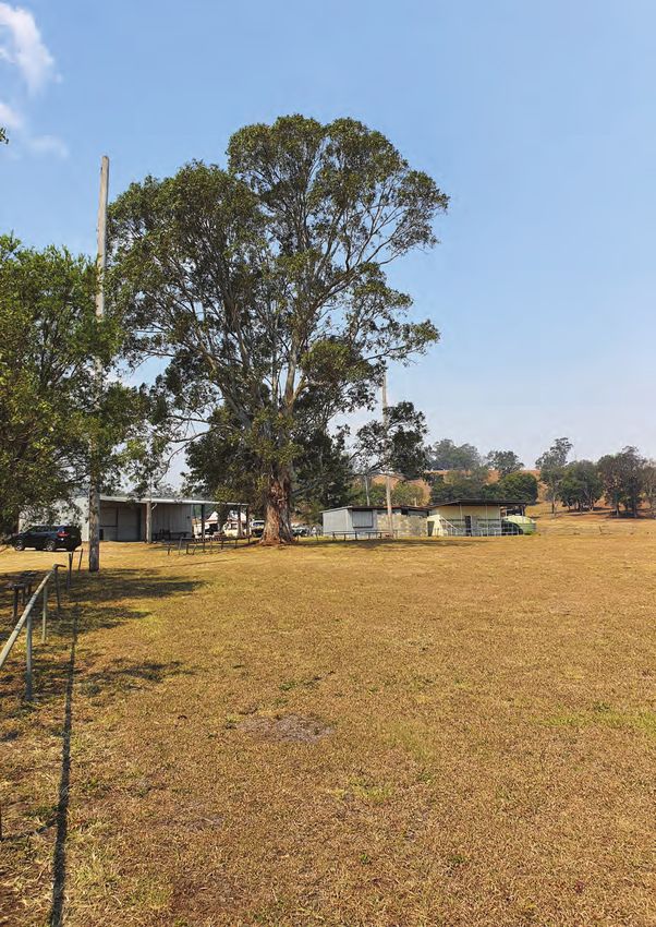
3.3.6 Land use and current improvements
Mallanganee Park is currently developed for use as a sportsground
for cricket and various football codes. Primitive camping is catered
for on site with basic amenities. Generally, the condition of current
improvements and assets is poor and in need of replacement or
renewal.
3.3.7 Infrastructure and embellishments
Reticulated water and sewerage is not currently provided in
Mallanganee, however, there are plans to provide them in the I J
future.
The entry from Sandilands Street is framed by a gateway
Mallanganee Sportsground - P L A N O F M A N AG E M E N T
A. Memorial Park gate entry from Sandilands Street
constructed in 1951 and identified in the Kyogle LEP 2012 as
a locally significant heritage item. The gateway includes brick B. Internal entry road from Sandilands St into Park
columns with an archway and includes memorial plaques C. View across informal car parking and sports field
commemorating local residents lost in World Wars I and II. A
time capsule consisting of a brick column, approximately one D. View across sports field
metre high, is located adjacent the gateway. The time capsule E. Typical post and plain/barbed wire fencing
commemorates the Mallanganee and District Centenary 1878 -
1978 and is to be opened in 2028. F. Bench seating and field boundary fence
G. Informal car parking
Timber post and plain or barbed wire fencing runs along the
property boundary. The sports oval is defined by a post and rail H. T. H. (Tom) Furhmann memorial plaque
fence, made from galvanised pipe, with steel gates. Fencing is in I. Time capsule to be opened in 2028
poor condition. J. Disused cricket practice net
14An avenue of Jacarandas on the northern edge of the site near the
entry perpetuate the memory of T. H. (Tom) Furhmann, accidentally
killed in January 1983.
Primitive camping is permitted on site and approximately six
concrete pads/slabs are provided, however, they are in poor
condition.
3.3.8 Access, circulation and parking
Vehicle access is primarily from Sandilands Street. A decorative A B
arched gateway marks the entrance and is approximately 3m
high, restricting access by vehicles exceeding this height, at this
entrance. A secondary access and egress is located off Pine Street.
Internal roads within the park are formed, however, are not
currently sealed.
There are several concrete pads for the convenience of those
camping at the park with recreation vehicles (RVs). Generally,
vehicle parking is not defined.
3.3.9 Lighting C D
While timber lighting posts indicate that the field may have
been lit in the past, there is currently no field lighting. Lighting
is currently available in buildings located on the park. There is
currently no floodlighting or field lighting at the park.
3.3.10 Play equipment
The playspace includes a single unit with multiple elements and a
double swing set.
3.3.11 Toilets and park furniture
E F
There are toilets located in the change room building and the
concrete block building located in the park. A toilet block in poor
condition is located at the entrance to Memorial Park servicing the
playground near the entrance to the park. Park furniture is limited
to bench seats and table and chair settings in poor condition.
3.3.12 Stormwater and drainage
Drains on the boundary of the park catch and drain stormwater
from the site.
3.3.13 Buildings G H
There are currently four buildings in the park:
• large maintenance shed constructed with corrugated iron walls
and roof, with concrete flooring and an awning facing the field
(dirt floor)
• small corrugated iron building, used as a canteen or bar
• concrete block toilet block
• timber building, including showers and change rooms with an
awning and concrete flooring.
I J
Mallanganee Sports Ground - P L A N O F M A N AG E M E N T
A. Memorial Park gate entry from Sandilands Street
B. Memorial Park gate with playground in background
C. Playground with shade sail, shelter and toilet
D. Play equipment
E. Public toilet
F. Sportsground and goalposts
G. Concrete cricket wicket
H. Maintenance shed with awning
I. Change rooms with tiered seating under awning
J. Steel and timber slate tiered seating under awning
15Mallanganee Sportsground - P L A N O F M A N AG E M E N T
16
PLAN OF MANAGEMENT4.0 THE PLAN OF MANAGEMENT
4.1 Aims of the Plan of Management
The Plan of Management for Mallanganee Park aims to:
• fulfil Council’s statutory obligations in respect to public land management under the requirements of the Local Government Act 1993
• provide a framework and maximise opportunities for sustainable, long-term management of community land
• be consistent with Council’s strategic plans and provide a basis for prioritising capital and operational works programming and
budgets
• maximise utilisation of the land for community use within Council’s capacity
• respond to current needs and opportunities, as well as provide guidance for future development
• reflect the values and expectations of key stakeholders and the local community, for future use and enjoyment of Mallanganee Park
• be a resource for both Council staff and the public regarding the use of the land, including leasing and licensing.
4.2 Core objectives of this Plan of Management
The Local Government Act sets out core objectives for the management of community land. The core objectives for the category of
general community use are below:
To promote, encourage and provide for the use of the land, and to provide facilities on the land, to meet the current and future needs of
the local community and of the wider public:
A) In relation to public recreation and the physical, cultural, social and intellectual welfare or development of individual members
of the public
B) In relation to purposes for which a lease, licence or other estate may be granted in respect of the land (other than the provision
of public utilities and works associated with or ancillary to public utilities).
4.3 Use and Development of Community Land at Mallanganee Park
4.3.1 Zoning
The community land covered by this Plan is zoned RU1 Primary Production
Table 6. Existing land title, tenure and zoning
Legal descriptor Approx. area ha Owner Control and mngt LEP 2014 zoning Current category
Lot A DP 367971 1.9747 Kyogle Council Kyogle Council RU1 Primary General community
Production use
Lot B DP 367971 0.1457 Kyogle Council Kyogle Council RU1 Primary General community
Production use
4.3.2 Development allowed in RU1 Primary Production Zone
The objectives of the RU1 zone are to:
• encourage sustainable primary industry production by maintaining and enhancing the natural resource base
• encourage diversity in primary industry enterprises and systems appropriate for the area
• minimise the fragmentation and alienation of resource lands
• minimise conflict between land uses within this zone and land uses within adjoining zones
• ensure that the productive capacity of agricultural land is appropriately recognised and managed
• enable a range of other uses to occur on rural land providing such uses do not conflict with existing or potential agriculture and do
not detract from the scenic amenity and character of the rural environment.
Consent is not required for activities including environmental protection works, extensive agriculture, home-based child care, home
occupations and intensive plant agriculture.
Mallanganee Sports Ground - P L A N O F M A N AG E M E N T
The following activities are permitted with the consent of Council in the RU1 zone:
Airstrips, animal boarding or training establishments, aquaculture, bed and breakfast accommodation, boat sheds, building identification
signs, business identification signs, camping grounds, caravan parks, cellar door premises, cemeteries, charter and tourism boating
facilities, community facilities, crematoria, dual occupancies, dwelling houses, ecotourist facilities, educational establishments,
environmental facilities, extractive industries, farm buildings, farm-stay accommodation, flood-mitigation works, forestry, function
centres, helipads, home businesses, home industries, industrial training facilities, information and education facilities, intensive livestock
agriculture, open-cut mining, plant nurseries, recreation areas, recreation facilities (outdoor), restaurants and cafes, roads, roadside stalls,
rural industries, rural supplies, rural workers’ dwellings, secondary dwellings, timber yards, turf farming, veterinary hospitals, water-
supply systems.
174.3.3 Permissible uses and developments
Table 7. Uses and developments allowed at Mallanganee Park
COMMUNITY LAND - GENERAL COMMUNITY USE Development to facilitate use
Purpose/Use
Providing a location for, and supporting, the • Provision of buildings or other amenity areas to facilitate use and enjoyment
gathering of community-based interest groups for a by the community, including licensed clubs and associated facilities, such as a
range of social, cultural or recreational purposes. refreshment room
Providing multi-purpose buildings (e.g. community • development of buildings and grounds for the purposes of addressing the needs
halls and centres) with specialised community uses, of a particular group
such as: • commercial operations, including primitive camping
• casual or informal recreation
• sports fields and courts
• meetings, including for social, recreational,
educational or cultural purposes • development to facilitate sporting use, such as lighting and fencing
• functions • benches, picnic tables, shade structures
• concerts, including all musical genres • hard and soft landscaping
• performances, including film and stage • water-saving initiatives, such as stormwater harvesting, rain gardens and swales
• exhibitions, fairs, parades • energy-saving initiatives, such as solar lights and solar panels, where appropriate
• leisure or training classes • car parking and loading areas, driveways, access roads or similar
• children’s services • bridges, boardwalks, etc.
• social services • locational, directional, regulatory, heritage and cultural interpretation signage
• designated group use, such as scout and girl • utilities to improve amenity or safety of the reserve, e.g. CCTV cameras.
guide use Advertising and promotional structures and signage (such as A-frames and banners) that:
• entertainment facilities of appropriate scale • relate to approved uses/activities
• community-based commercial operations, • are discreet and temporary
which are sympathetic to and support use in • are approved by Council.
the area and are of appropriate scale.
The scale and intensity of current and proposed uses for Mallanganee Park is detailed in the table below.
Table 8. Scale and intensity of any permitted use or development at Mallanganee Park
USE or DEVELOPMENT SCALE INTENSITY
Buildings (community recreation club, Subject to Council approval The intensity of use is not to cause nuisance to
clubhouse, amenities etc.) nearby residents and must comply with lease or
licence conditions and relevant Council policies.
Community-based interest group activities Subject to Council approval The intensity of use is not to cause nuisance to
nearby residents and must comply with lease or
licence conditions and relevant Council policies.
Organised sport and training Limited to the physical constraints of the sports Subject to conditions of casual or seasonal hire
fields agreements with Council.
Passive recreation uses Small scale The intensity of use is not to cause nuisance to
nearby residents.
Landscape upgrades - natural (tree planting) Scale is not to compromise use of the site for To enhance the site, in terms of aesthetics,
active and passive recreation climate control and habitat.
Landscape upgrades - amenity (installation of Scale is not to compromise use of the site for Low intensity so as to not compromise the
seats, toilets etc.) active and passive recreation natural and open character of the site. Sufficient
provision to enhance the amenity of the site, in
terms of comfort and convenience.
Infrastructure to support the environment Appropriate scale Scale to suit the community land category
(fencing, boardwalks, drystone walling etc.)
Car parks Limited to dedicated car parks provided, and to 24 hours a day, 7 days a week
future infrastructure provided
Roads and paths Limited to the dedicated roads and paths, and to 24 hours a day, 7 days a week
future infrastructure proposed
Mallanganee Sportsground - P L A N O F M A N AG E M E N T
Commercial development which is sympathetic Small scale Agreement, via lease, licence or permit,
to and supports uses in the area (bike hire, cafe, approved by Council
markets etc.)
Community events Limited to the physical constraints of the site Subject to Council approval
Sports and other lighting Suitable for regional and district level sports Times subject to Council approval. Lighting to
ground comply with Australian Standards
Public art and signage Scale and style to suit character of site Limited amount to provide appropriate impact
and help reinforce local identity
Sportsground maintenance Subject to noise, occupational health and safety , Seven days a week, subject to Council approval
and any other relevant legislation
Camping Subject to Council approval The intensity of use is not to cause nuisance to
nearby residents and must comply with relevant
Council approvals
184.3.4 Leases, licences and other estates
Leases, licences and other estates over community land must be expressly authorised in Plans of Management and comply with the
conditions in the Local Government Act. They must be in the best interests of the community, as a whole, and enable , wherever possible,
shared use of community land. The term other estates includes other interests, charges, rights or titles in relation to the land (for
example, easements).
The main difference between a lease and a licence is that a licence does not permit the sole, or exclusive, use of the area. Licences may
be granted to formally recognise and endorse shared uses. Licences are commonly used for sports facilities, such as clubhouses.
Maximu m term a n d publ i c n o t i ce
The maximum term of a lease, licence or other estate is 30 years. The consent of the Minister for Local Government is required if the
lease or licence exceeds 21 years. This consent is also required if the term of the lease or licence will be greater than five years and
objections have been lodged against the proposal. Council must give public notice of the proposal and exhibit notice of it on the land to
which the proposal relates. Council must consider all submissions made in response.
Granting a l ea s e o r l i ce n ce
The grant of a lease or licence is an important step in using community land, but there may be other requirements relevant to any
proposed use. For example, development consent may be required under the Environmental Planning and Assessment Act 1979. Any
interested person should check carefully to ensure they are aware of all relevant requirements.
A lease, licence or other estate must not be granted, if it involves:
• an activity that is not in accordance with a permitted purpose
• an activity that is not consistent with the objectives of the Plan of Management
• any activity prohibited by the land zoning stated in Council’s current Local Environmental Plan (LEP).
Lease s, l icences a n d o t h e r e s t a te s a l l owe d i n M allan gan ee Par k
In accordance with the requirements of the Local Government Act 1993, this Plan of Management expressly authorises Council to grant
a lease, licence or other estate at Mallanganee Park, where the activity is consistent with this POM and the core objectives for the
category of land, and is for a purpose listed in Table 5.
Table 9. Purposes for which leases, licences and other estates may be authorised by Council at Mallanganee Park
Type of arrangement Category of community Purpose
land
Lease General Community Use • licensed community recreation club and associated facilities
• classes and workshops for activities, such as yoga, dance, art and craft
• community-based interest groups for a range of social, cultural, or recreational purposes
• commercial operations to activate the site and provide community recreation
• cafe (including outdoor dining area)
• health or medical practitioners associated with the relevant facility (e.g. nutrition,
physiotherapy)
• children’s services
• car parks
Licence General Community Use • community based interest groups for a range of social, cultural, or recreational purposes
• classes and workshops for activities, such as yoga, dance, art and craft
• small-scale commercial uses, e.g. mobile cafe, hire of sports and recreation equipment
Other estate All categories This POM allows Council to grant an estate over community land for the provision of public
utilities and works associated with or ancillary to public utilities in accordance with the Local
Government Act 1993. Estates may also be granted across community land for the provision
of pipes, conduits, or other connections under the surface of the ground for the connection
of premises adjoining the community land to a facility of the Council or other public utility
provider that is situated on community land.
Short-term casual permit General Community Use • small-scale functions, displays, exhibitions, concerts
• public speeches, meetings, seminars and presentations
• community events, auctions, markets and similar activities
• classes and workshops for activities, such as yoga, dance, art and craft
Mallanganee Sports Ground - P L A N O F M A N AG E M E N T
• small-scale commercial uses, e.g. mobile cafe, hire of sports and recreation equipment.
194.4 Management objectives and actions for Mallanganee Park
The following management objectives support environmental protection, active and passive recreation, social connection, appropriate
commercial recreation and visual amenity.
Develo p a q u a l ity p u bl i c e n v i r o n m e n t
By ensuring the creation of comfortable and engaging environments.
I mpr ove p ed estria n a n d cyc l i n g a m e n i ty
By encouraging an increase in these forms of transport by improving the appeal of the environment to pedestrians and cyclists.
I mpr ove co mmu n ity s a fe ty
Through the promotion of CPTED to achieve natural surveillance of public spaces and active frontages.
I nc rease a ccess ib il ity a n d i n tegr a t i o n
By ensuring that the activity centre (i.e. recreation reserve, open/public space) is a focus for the entire community, is accessible to all and
physically integrated within the surrounding neighbourhood.
Encour a g e a mix of us e s
By optimising the diversity of uses to promote vitality, extend the hours of activity and intensify the use of existing infrastructure.
Encour a g e enviro nm e n t a l s us t a i n a bi l i ty
By promoting efficient use of existing assets, prolonged life cycle of structures and encouraging energy efficiency, water and resource
conservation.
Mallanganee Sportsground - P L A N O F M A N AG E M E N T
204.5 Objectives and performance targets
Table 10. Objectives and performance targets for Mallanganee Memorial Park
Management objectives Performance targets How to achieve objectives and performance targets Assessment of performance
regarding objectives and
Refer Kyogle Open Space Design Guide performance targets
Develop a quality public Open space is designed Aim for all open spaces to comply with the Open Space Regular inspections of parks
environment to be comfortable and Design Guide and sportsgrounds confirm
engaging appropriate standard of
Maintain open spaces to the level required in the Parks and amenity and quality to relevant
Provide play spaces at Reserves Asset Management Plan Australian Standards.
appropriate locations
Parks and sportsgrounds have shade and seating Parks and sportsgrounds are
Public art reflecting the regularly inspected to ensure
community is integrated Design parks that: good maintenance.
into public spaces • preserve the natural environment for contemplation,
reflection and inspiration Survey of users to ascertain
satisfaction.
• invoke a sense of place
• ameliorate mental fatigue Community/stakeholder forums
provide regular feedback on
• inspire artistic expression. passive and active recreation
needs.
Improve pedestrian and Provide linkages with Provide wide, shaded, pedestrian and cycle paths to Surveys reveal users are
cycling amenity nearby destinations and accommodate mobility scooters and prams within parks and satisfied with linkages provided
open spaces sportsgrounds and to other destinations, such as town/village within open spaces and to other
centres destinations.
Create a connected network of walk and cycle paths that link
people to where they want to go (key destinations) including
passing through parks and sportsgrounds.
Improve community Open space is designed Provide, where appropriate: Lighting is adequate and
safety to support natural • pedestrian lighting, particularly along perimeter pathways appropriate for each open space.
surveillance and active to make parks and sportsgrounds safer
frontages
• safety lighting for cycle paths through parks and Participants in night sport
sportsgrounds report that lighting is
satisfactory.
• floodlighting to enable night-time training at
sportsgrounds Surveys reveal that users feel
• solar lighting, if possible safe in parks and sportsgrounds.
Provide well-managed unleashed areas for social use by dogs
and their owners
Increase accessibility Ensure fairness and Provide, where appropriate: Surveys of user groups reveal
and integration equity in use of parks • ramps, handrails, tactile etc. that no group is unfairly
and sportsgrounds disadvantaged.
• obvious entries and signage
Provide signage to • access for maintenance and emergency vehicles, and Parking is adequate for all parks
support and encourage service authorities and sportsgrounds, most of the
use time.
• car parking
• water-sensitive urban design
Ensure leases and licences do not overly limit public use by
providing exclusive use to lessees/licensees
Ensure revenue from events and activities in parks and
sportsgrounds is based on ‘user pays’ philosophy
Encourage a mix of uses Open space is designed Parks and sportsgrounds provide, where appropriate: Survey of users to ascertain
and embellished to • sport fields for formal sports satisfaction.
maximise diverse uses
• space for unstructured activity Community/stakeholder forums
• playgrounds that encourage creative and independent play provide regular feedback on
passive and active recreation
• large level areas for passive recreation and community needs.
events
Mallanganee Sports Ground - P L A N O F M A N AG E M E N T
• facilities for a variety of ages (older people and younger Surveys reveal users are
people) satisfied with linkages provided
within open spaces and to other
• pedestrian and cycle paths destinations.
• quiet areas for reflection
21Encourage Encourage energy Provide solar lighting, if possible and appropriate Steady increase in the number
environmental efficiency, water and of participants in bushland
sustainability resource conservation Incorporate water-sensitive urban design elements into open management issues and
spaces, where appropriate: activities.
Manage Council’s • grassed swales
natural areas to a high Reduction in level of gross
standard • rain gardens pollutant, sediment and
• water-collecting tree pits and medians nutrient-enriched stormwater
and septic tank effluent entering
• bio-retention basins natural areas.
• water tanks to harvest stormwater
No unacceptable fragmentation
Implement water quality improvement programs in a or deterioration of natural area
coordinated and efficient manner quality, as a result of recreation
facilities.
Stabilise and monitor stormwater outlets and creek-line
erosion in conjunction with Catchment Management Plans, There is a steady, measurable
where necessary increase in the number of WSUD
elements incorporated into
open spaces.
Mallanganee Sportsground - P L A N O F M A N AG E M E N T
22You can also read