Greening Our Neighbourhoods 2021-28 - Urban Forest Strategy - DRAFT - Greater Dandenong
←
→
Page content transcription
If your browser does not render page correctly, please read the page content below
DRAFT                                                                             City of Greater Dandenong
                                                            Greening Our Neighbourhoods Strategy 2018-2028

Greening Our Neighbourhoods 2021-28
Urban Forest Strategy

Prepared by Strategic, Design and Sustainability Planning

                                               Page | 1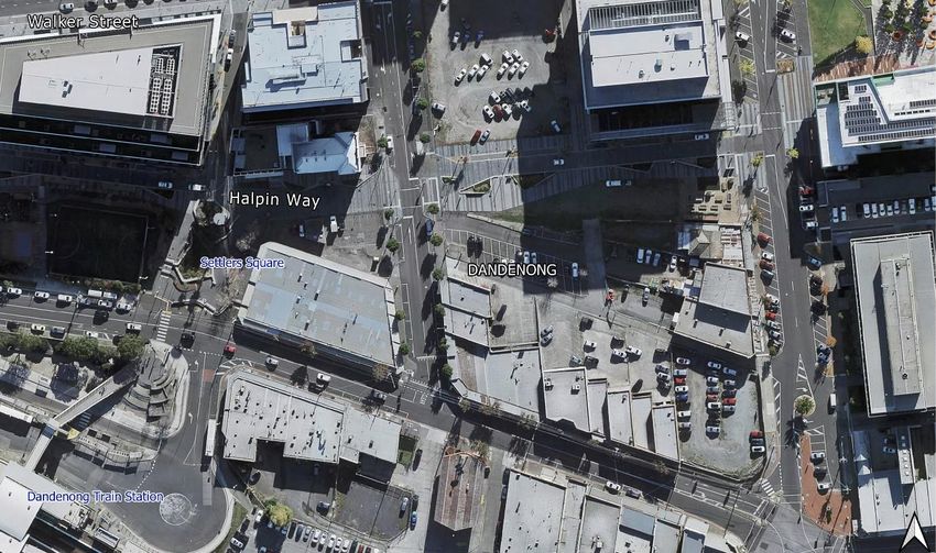
DRAFT                                                                                                                           City of Greater Dandenong
                                                                                                          Greening Our Neighbourhoods Strategy 2018-2028

Contents

Executive Summary................................................................................................................................. 3
1. Introduction ........................................................................................................................................ 4
   1.1 Background ................................................................................................................................... 4
   1.2 Purpose ......................................................................................................................................... 5
   1.3 Urban forest and climate change.................................................................................................. 6
2. Benefits to greening (this page will be made into graphics) .............................................................. 7
3. Vision and objectives .......................................................................................................................... 8
4. What is an urban heat island? ............................................................................................................ 9
5. Canopy cover on privately-owned land in Greater Dandenong ....................................................... 13
6. Council’s ability to protect and enhance trees ................................................................................. 15
7. Opportunities and issues for privately-owned land ......................................................................... 16
   7.1 Urban development and infrastructure ...................................................................................... 16
       Issues for urban development and infrastructure ........................................................................ 16
       Urban residential .......................................................................................................................... 16
       Activity centres and retail ............................................................................................................. 19
       Large areas of car parking ............................................................................................................. 20
       Industrial ....................................................................................................................................... 21
       Opportunities for urban development and infrastructure ........................................................... 22
   7.2 Green Wedge .............................................................................................................................. 23
8. Integrated water management ......................................................................................................... 25
9. Community perception of trees ........................................................................................................ 27
10. Action plan ...................................................................................................................................... 28
11. Monitoring and review ................................................................................................................... 38
Glossary ................................................................................................................................................. 39
Bibliography .......................................................................................................................................... 41

                                                                           Page | 2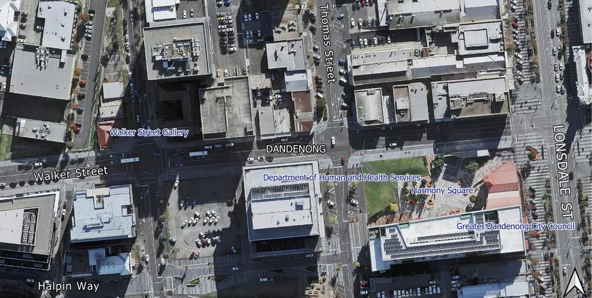
DRAFT                                                                                       City of Greater Dandenong
                                                                      Greening Our Neighbourhoods Strategy 2018-2028

Executive Summary
Greening Our Neighbourhoods 2021-28 forms one part of the Greater Dandenong Urban Forest
Strategy 2021-28 and should be read in conjunction with this and Greening our City: Urban Tree
Strategy 2018-28.

Greening Our Neighbourhoods strives for a proactive and collaborative response by the Greater
Dandenong City Council and community in managing vegetation and canopy cover on privately-
owned land. The strategy aims to demonstrate the value of trees and vegetation in shading our
urban environment to reduce the urban heat island, respond to climate change, improve the
amenity of our streets and the health of our community.

Greater Dandenong City Council on 28 January 2020 declared a ‘Climate and Ecological Emergency’
committing Council to emergency action on climate change. The urban forest, which is the sum of all
vegetation and trees on private and public land, plays a significant role in mitigating against climate
change for the benefit of our local community and environment. Greater Dandenong has an overall
canopy cover of 9.9 per cent which is the lowest canopy cover on the eastern side of Melbourne.
This is a significant contributor to Greater Dandenong being the 7th hottest municipality in
metropolitan Melbourne. Urban heat islands intensify extreme heat events and have detrimental
impacts on the health and wellbeing of communities.

Greater Dandenong is the most disadvantaged municipality in metropolitan Melbourne. Vulnerable
people, such as the elderly, children, people living with a disability and those from low socio-
economic backgrounds are at an even greater risk to extreme heat events and a changing climate.
This combined with Greater Dandenong having a very low canopy cover and higher temperatures
than most other metropolitan Melbourne municipalities has resulted in the population in large areas
of Greater Dandenong’s suburbs having been assessed as being of High Vulnerability. The population
in these areas of Greater Dandenong are considered to be ‘highly vulnerable to urban heat due to
high heat exposure (lack of shade), sensitivity to heat and low adaptive capability (low socio-
economic demographic, people living with a disability, the elderly and children)’. It is therefore
vital, we, as a Council and community, work to respond to the impacts of climate change, to green
and cool our neighbourhoods and make our community more resilient.

Greening Our Neighbourhoods has a shared vision with the Urban Forest Strategy for:

A healthy, green and resilient urban forest that is well managed, protected and provides benefits to
the community.

The key objective of this strategy is to cool, through greening our neighbourhood.

The strategy advocates for a more resilient and greener urban environment through higher quality
landscaping and an enhanced urban forest. A particular focus is an increase in canopy trees on
privately-owned land that contribute to increasing Greater Dandenong’s canopy cover to 15 per cent
by 2028.

                                                 Page | 3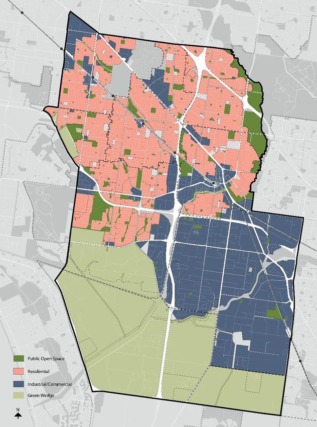
DRAFT                                                                                      City of Greater Dandenong
                                                                     Greening Our Neighbourhoods Strategy 2018-2028

1. Introduction

Greening Our Neighbourhoods should be read in conjunction with the City of Greater Dandenong’s
Urban Forest Strategy and Greening Our City: Urban Tree Strategy 2018-28.

Greening Our Neighbourhoods advocates for a more resilient and greener urban environment
through higher quality landscaping and canopy trees on private land that contribute to increasing
the City of Greater Dandenong’s canopy cover to 15 per cent by 2028.

1.1 Background
Greening our Neighbourhoods has been prepared in response to the ‘Future Considerations’ section
of Greening our City: Urban Tree Strategy 2018-28 and community feedback for stronger guidance
on managing and enhancing canopy cover on privately-owned land. Together with the Urban Forest
Strategy (the parent document), Greening Our City and Greening Our Neighbourhoods provide a
holistic approach to managing and enhancing the urban forest, and work together to deliver a
healthy, green and resilient urban forest.

The term urban forest includes all vegetation, big and small, native and non-native growing on
private and public land and buildings. While all vegetation contributes to the urban forest, canopy
trees on privately-owned land make an immense contribution to the urban forest and deliver
personal benefits to occupants, neighbours and the wider community.

Figure 1 demonstrates the relationship between the Urban Forest Strategy, Greening Our City and
Greening Our Neighbourhoods.

Figure 1 Structure of Urban Forest suite of strategies

                                                         Page | 4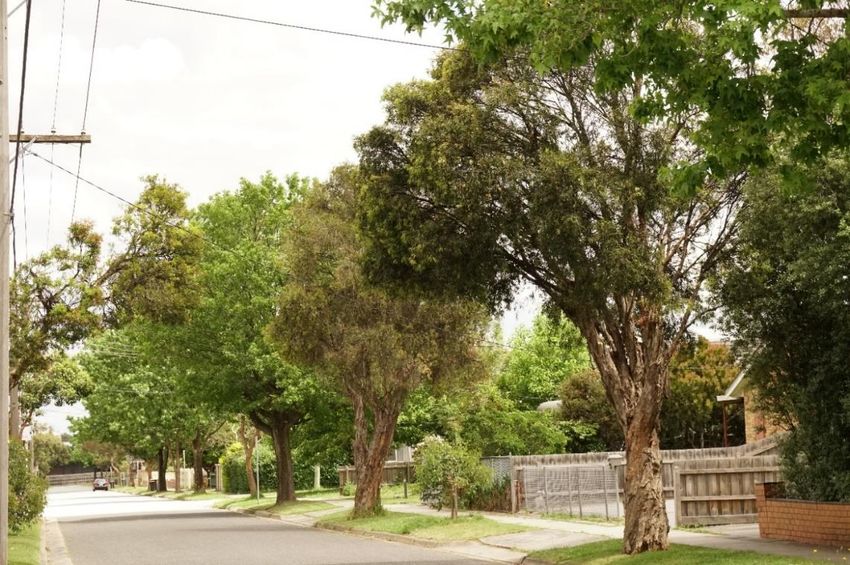
DRAFT                                                                                    City of Greater Dandenong
                                                                   Greening Our Neighbourhoods Strategy 2018-2028

        QUOTE BOX to be graphically designed

        Private property or privately-owned land is land owned by a private entity or
        individual (includes land owned by private and government agencies i.e. Melbourne
        Water, Department of Education or Department of Human and Health Services).
        This does not include Crown land or land owned by Council. Private land includes
        land broadly zoned for residential, commercial, industrial and rural purposes (i.e.
        Green Wedge).

1.2 Purpose
This strategy will:

    •    Consider the current challenges to protecting and enhancing canopy cover on privately-
         owned land
    •    Identify ways Council and the community can enhance tree canopy on privately-owned land
    •    Build the knowledge of our community, including developers, on the most appropriate
         species and maintenance regimes for privately-owned land
    •    Advocate and encourage landowners, businesses and developers to retain green
         infrastructure including canopy trees and incorporating green walls and green roofs into
         landscape designs.

Greening Our Neighbourhoods strives for a proactive and collaborative response by the Greater
Dandenong City Council and community in managing and enhancing vegetation and canopy cover on
privately-owned land. The strategy aims to demonstrate the value of trees in shading our urban
environment to reduce the urban heat island, adapt to climate change, improve the amenity of our
streets and the health of our community.

                                               Page | 5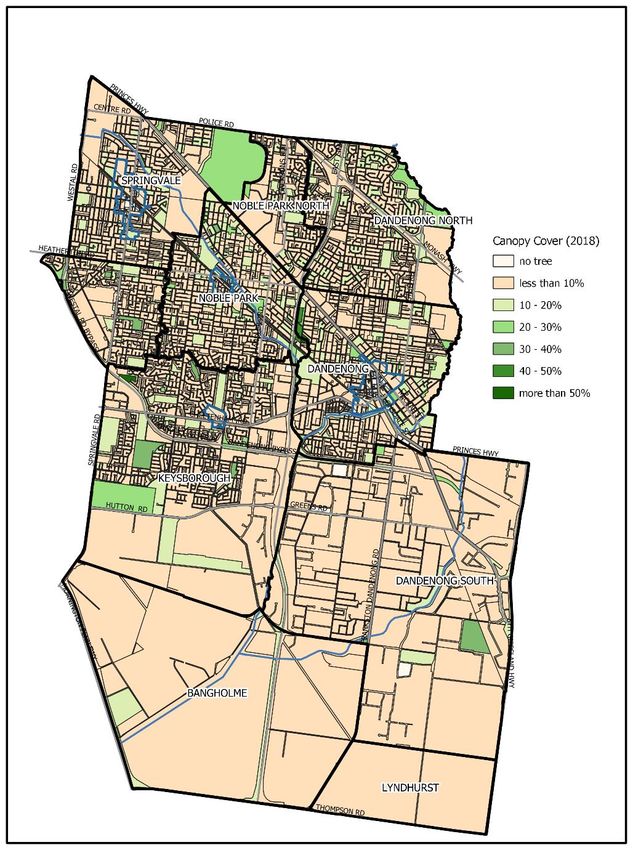
DRAFT                                                                                      City of Greater Dandenong
                                                                     Greening Our Neighbourhoods Strategy 2018-2028

1.3 Urban forest and climate change
Climate change is already affecting our environment, our society
and our economy. As individuals, it can cause drastic impacts on
our physical and mental health and on our financial health.
Greater Dandenong City Council declared a ‘Climate and
Ecological Emergency’ on 28 January 2020, and on 24 August
2020 adopted the Climate Emergency Strategy 2020-2030
committing us to emergency action on climate change.

The City of Greater Dandenong is the most disadvantaged municipality in metropolitan Melbourne.
Vulnerable people, such as the elderly, children, people living with a disability and those from low
socio-economic backgrounds are at an even greater risk to extreme heat events and a changing
climate. This combined with the City of Greater Dandenong having a very low canopy cover and
higher temperatures than most other metropolitan Melbourne municipalities has resulted in the
population in large areas of the City of Greater Dandenong’s suburbs having been assessed as being
of High Vulnerability. The population in these areas are considered to be ‘highly vulnerable to urban
heat due to high heat exposure (lack of shade), sensitivity to heat and low adaptive capability (low
socio-economic demographic, people living with a disability, the elderly and children)’.

A recent study on urban heat islands found the City of Greater Dandenong was the 7th hottest
municipality in metropolitan Melbourne. Urban heat islands have detrimental impacts on the health
and wellbeing of our community and the comfort levels of our homes and workplaces.

Shade trees, while being part of our efforts to store carbon
levels to reduce impacts of climate change, just as
importantly can help cool neighbourhoods and minimise
these risks. For the City of Greater Dandenong, the urban
forest is as much about greening our streets, car parks and
industrial precincts as it is about greening our gardens and
our homes.

It is therefore vital, we, as a Council and community, work to respond to the impacts of climate
change, to cool and green our neighbourhoods and make our community more resilient.

*Images on this page are placeholders and have not been finalised.

                                                    Page | 6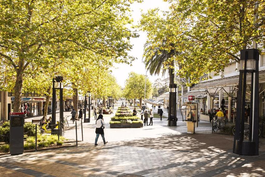
DRAFT                                                                                               City of Greater Dandenong
                                                                              Greening Our Neighbourhoods Strategy 2018-2028

2. Benefits to greening
*the list of benefits will be graphically designed

Environmental

    -    Canopy trees help cool urban environments and can reduce daytime surface temperatures
         by between 5-20°C
    -    Trees support a healthy and diverse ecosystem by providing habitat and wildlife corridors for
         local and migratory wildlife
    -    Trees can help regulate stormwater runoff, reducing demand on drainage infrastructure,
         reducing intensity of localised flood and assisting in the improvement of water quality.
    -    Trees act as wind buffers on agricultural land minimising the loss of topsoil and providing
         shelter to grazing animals.

Economic

    -    Tree-lined streets attract more foot traffic and can lead to increased spending and
         investment1
    -    Residential land values can increase in streets with street trees, compared to nearby streets
         with no street trees2
    -    Appropriately placed trees can realise financial savings up to 50 per cent on daytime air
         conditioning for businesses and 12-15% for residential properties3
    -    The presence of nature, access to clean air and cooler environments improves human health
         by reducing stress and blood pressure thus reducing demand on health systems4
    -    Vegetation, such as fruit trees or vines and vegetable gardens, contribute to local food
         production which can lead to reduced grocery costs and healthier communities

Social

    -    Treed landscapes foster active and passive recreation whilst improving physical and mental
         health by increasing energy levels, reducing stress and decreasing blood pressure
    -    Reduced heat mortality rates for elderly and vulnerable people including reduced heat-
         related illnesses including heat exhaustion, damage to medications and stress
    -    Leafy areas can provide a comfortable outdoor place to gather with loved ones and build
         community networks and strengthen communities by promoting contact, encouraging
         physical activity, reducing stress and stimulating social cohesion
    -    Provide protection against skin cancer by reducing UV-B exposure (the most damaging type
         of solar radiation) by approximately 50%
    -    Children function better than usual after activities in green settings, and ‘greener’ play areas
         can lead to less severe attention deficit symptoms5

1
  (Georgia Urban Forestry Publication, 2004; Mullaney, et al., 2015)
2
  (Pandita, et al., 2013; Mullaney, et al., 2015; Pandit, et al., 2012; Moore, 2020)
3
  (Georgia Urban Forestry Publication, 2004; Mullaney, et al., 2015; Moore, 2020)
4
  (Van Dillen, et al., 2012)
5
  (Taylor, et al., 2001)

                                                      Page | 7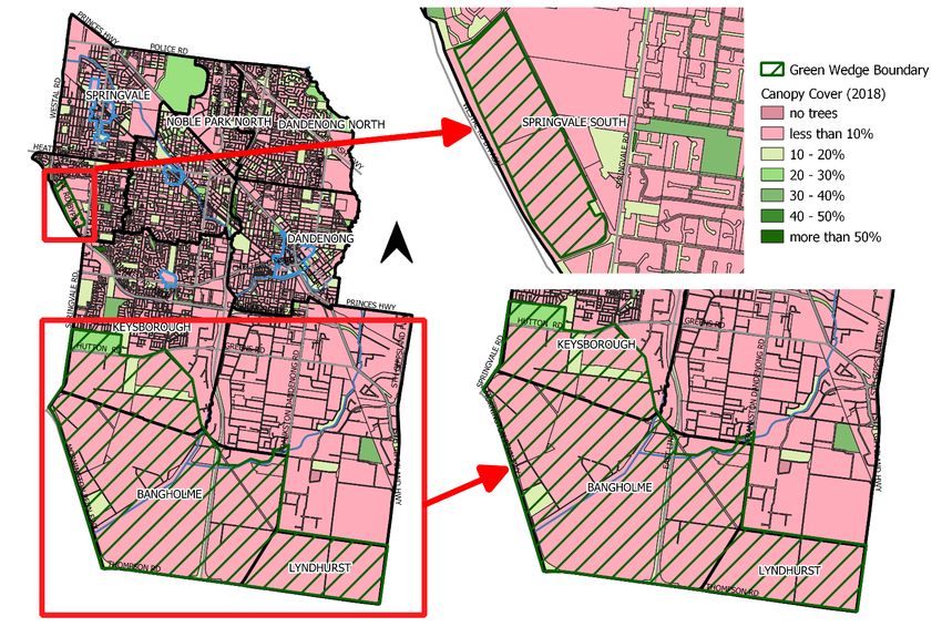
DRAFT                                                                                   City of Greater Dandenong
                                                                  Greening Our Neighbourhoods Strategy 2018-2028

    -   Contribute to a safer neighbourhood through appropriate design responses

Amenity

    -   Trees enhance our neighbourhoods and are considered the most important indicator of
        attractiveness in a community
    -   Trees contribute to the character of a neighbourhood by framing and screening views,
        softening the built environment and absorbing sound waves reducing urban noise
    -   Natural barriers to wind

3. Vision and objectives

A healthy, green and resilient urban forest that is well managed, protected and provides
benefits to the community.

Objective: Cool through greening our neighbourhood

Strategies:

    •   Council will continue to advocate for high quality landscape design and the inclusion
        of canopy trees on private land.
    •   Council aims to reduce the urban heat island and cool our neighbourhoods to
        improve our community’s health and resilience in a changing climate.
    •   Council aims to increase our urban forest to help sequester carbon as part of the City
        of Greater Dandenong’s climate change mitigation measures.
    •   Council aims to improve the skillset of our development community by preparing a
        set of landscaping guidelines to achieve high quality landscaping in all developments.
    •   Council will work to expand and enhance its provision of educational programs that
        aim to improve the perception of trees and landowners’ and residents’ knowledge of
        species selection and maintenance.

The Action Plan at page 27 details a series of actions to achieve each of the strategies above.

                                              Page | 8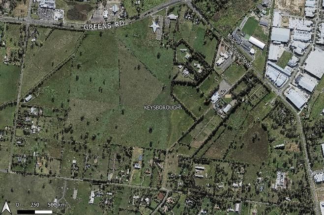
DRAFT                                                                                        City of Greater Dandenong
                                                                       Greening Our Neighbourhoods Strategy 2018-2028

4. What is an urban heat island?

The term “urban heat island” refers to the temperature difference between built up (urban) areas
compared to the rural surrounds (Figure 2). This temperature difference occurs due to the increased
hard and dark surfaces in built up areas that absorb and radiate heat and is worsened by a lack of
shade provided by vegetation and canopy trees.

 Figure 2 Urban Heat Island Effect

The Urban Forest Strategy established that the City of Greater Dandenong is already experiencing
these effects, with our municipality measured as the 7th hottest in the metropolitan area (9.26°C
hotter than the baseline land surface temperature).

The urban heat island (UHI) effect can have detrimental impacts on the health and wellbeing of our
community and the comfort levels of our homes and workplaces.

These impacts are clearly seen in heat waves, during which our homes absorb significant amounts of
heat and are unable to cool down. This results in a greater reliance on air conditioning to artificially
cool our homes to a comfortable temperature. Heat waves cause severe health impacts and can
have significant financial strain on many families and individuals.

Research has shown greening private backyards can significantly reduce urban heat, with canopy
trees reducing daytime surface temperatures by between 5-20°C which in turn reduces the ambient
air temperature. This occurs through canopy trees shading hard and dark surfaces and through the
process of evapotranspiration.

Evapotranspiration is the combination of two processes: evaporation and transpiration. These
processes cause water to evaporate from plant leaves, releasing moisture into the air and cooling
down the plant and the surrounding environment.

                                                 Page | 9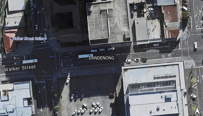
DRAFT                                                                                                City of Greater Dandenong
                                                                               Greening Our Neighbourhoods Strategy 2018-2028

As identified in the Urban Forest Strategy
2021-28, many suburbs in the City of Greater
Dandenong have been identified as having
‘High Vulnerability’ to urban heat.

Decreases in the ambient air temperature of
between 1 and 2°C significantly reduce heat
mortality rates for frail, elderly and
vulnerable people. Canopy trees provide
maximum cooling benefits when and where
it is most needed – during extreme heat
events and close to individuals and families,
and the communities in which we live.
                                                      Figure 3 Image taken using thermal image camera on a 33°C day, 14
                                                      December 2020 at 2pm (Dandenong West).

                                                      The maximum temperature recorded was 77°C on the roof. Yellow
                                                      indicates hotter temperatures, and purple indicates cooler
                                                      temperatures with a minimum of 25°C recorded under the shade of
                                                      the tree.

                Figure 4 The average difference (°C) in Land Surface Temperature (LST) to baseline
                LST (°C) between LGAs. Based on Lidar technology. (Sun, et al., 2019)

                                                      Page | 10
DRAFT City of Greater Dandenong
Greening Our Neighbourhoods Strategy 2018-2028
Walker Street, Dandenong Activity Centre
Figure 4 Image taken using a thermal image camera on a 36°C day, 25 January 2018 at 4pm (Walker Street,
Dandenong) demonstrating the role of canopy trees in reducing daytime surface temperatures.
The temperature recorded in the centre of the photo is shown on the top left corner, in this image the
temperature at the centre point was 39.2°C.
Yellow indicates hotter temperatures purple indicates cooler temperatures.
Red arrows demonstrate where thermal image was taken from.
*Images to be graphically designed
Page | 11DRAFT City of Greater Dandenong
Greening Our Neighbourhoods Strategy 2018-2028
Halpin Way, Dandenong Activity Centre
Figure 5 Image taken using a thermal image camera on a 36°C day, 25 January 2018 at 4pm (Halpin Way,
Dandenong) demonstrating the role of canopy trees in reducing daytime surface temperatures.
The temperature recorded in the centre of the photo is shown on the top left corner, in this image the
temperature at the centre point was 57.4°C.
Yellow indicates hotter temperatures and purple indicates cooler temperatures.
Red arrows demonstrate where thermal image was taken from.
*Images to be graphically designed
Page | 12DRAFT City of Greater Dandenong
Greening Our Neighbourhoods Strategy 2018-2028
5. Canopy cover on privately-owned land in Greater Dandenong
In the City of Greater Dandenong, 73 per cent of land is privately-
owned. Privately-owned land includes land owned by private
residents and businesses broadly zoned for residential,
commercial, industrial and rural purposes (i.e. the Green Wedge).
The remainder is publicly owned and includes parks, footpaths,
road and infrastructure reserves and Council buildings. The large
proportion of private land is not unique to the City of Greater
Dandenong and presents a significant challenge, shared amongst 73 percent
other councils, in managing the urban forest. of land privately owned
Council has direct control over the land it owns and can strongly
influence the number of trees planted in the public realm. Unfortunately, Council has limited ability,
beyond a decision-making and advocacy role, to increase canopy cover on privately-owned land.
Urban canopy cover for the Greater Dandenong municipality was 9.9 per cent in 2017. This is the
lowest canopy cover on the eastern side of Melbourne.
The following figures (Figures 6 and 7) show most of the land within the City of Greater Dandenong
is privately-owned, including the Green Wedge, and has less than 10 per cent canopy overall.
Privately-owned land in the City of Greater Dandenong has a canopy cover of 5.6 per cent, this is
slightly below that of canopy coverage on public land, being 9.1 per cent.
Research conducted by the Centre for Urban Research at RMIT University, in partnership with the
Department of Environment, Land, Water and Planning (DELWP) and the Clean Air and Urban
Landscapes Hub identified that residential land provides the largest contribution to tree canopy
cover across metropolitan Melbourne. However, due to a combination of urban re-development,
landowner land-management practices and climatic effects, vegetation cover on residential land is
decreasing across metropolitan Melbourne.
This research, using Lidar technology, identified that between 2014 and 2018 the City of Greater
Dandenong experienced a canopy cover loss of less than 1 per cent. The majority of this loss in
canopy cover can be attributed to the upgrading of the Cranbourne/Pakenham railway line, however
this figure is a result of the cumulative loss of canopy trees across the municipality. Whilst 1 per cent
is a small amount, it is lost from an already small baseline and therefore any loss of canopy cover is
concerning and must be addressed to mitigate the severe health and wellbeing consequences of
urban heat.
Table 1 Based on methodology using Lidar technology (Hurley, et al., 2018)
Percentage of Percentage of
tree cover tree cover
Residential Land 7.8 Publicly owned land 9.1
Commercial Land 4.8 Privately owned land 5.6
Industrial Land 3.4
Rural Land (Green Wedge) 5.0
Other 9.0
*Graph and tables to be graphically designed
Page | 13DRAFT City of Greater Dandenong
Greening Our Neighbourhoods Strategy 2018-2028
*Images on this page to be graphically designed
Figure 6 Map of the City of Greater Dandenong municipality tree cover 2018 Figure 7 Map of the City of Greater Dandenong showing basic land use zones
Based on methodology using Lidar technology (DELWP, 2019)
Page | 14DRAFT City of Greater Dandenong
Greening Our Neighbourhoods Strategy 2018-28
6. Council’s ability to protect and enhance trees
Council’s ability to protect and enhance canopy cover on privately-owned land is limited to a
decision-making and advocacy role. This includes administering the Greater Dandenong Planning
Scheme (the Planning Scheme).
The Planning Scheme contains multiple state and local policies and provisions which address tree
protection and can require the planting of new canopy trees. At a state level, the Planning Scheme
provides guidance and policy for environmental and landscape values including biodiversity, native
vegetation and significant landscapes. In addition, provisions at a state level exist to protect and
manage vegetation, including bushfire management, requirements for canopy trees in urban
development and protecting trees from being removed where they are deemed of environmental or
historical significance. These are relevant to Greening Our Neighbourhoods as they consider the
protection and enhancement of canopy cover on privately-owned land.
More specifically in the City of Greater Dandenong the existing local policies and provisions in place
include, but are not limited to:
• Clause 21.06 Open Space and Environment
• Clause 22.02 Green Wedge Local Policy
• Clause 22.03 Urban Design in Commercial and Industrial Areas
• Clause 22.04 Urban Design in Activity and Neighbourhood Centres
• Clause 22.06 Environmentally Sustainable Development
• Clause 22.09 Residential Development and Neighbourhood Character Policy
• Clause 32.07 Residential Growth Zone Schedule 1 and 2
• Clause 32.08 General Residential Zone Schedules 1, 2 and 3
• Clause 32.09 Neighbourhood Residential Zone Schedule 1
• Vegetation Protection Overlay Schedule 1 – Native vegetation in the main portion of the
Green Wedge
• Environment Significance Overlay Schedule 1 – Greens Road Plains Grassland Area
• Environmental Significance Overlay Schedule 2 – Abbotts Road Vegetation Protection Area
• Environmental Significance Overlay Schedule 3 – Eastern Treatment Plant Buffer Area
• Clause 43.01 Heritage Overlay
• Clause 53.18 Stormwater Management in Urban Development
Whilst these policies and provisions provide Council with the ability to protect and enhance canopy
cover in the municipality, Council needs the help of the community to plant trees on privately-
owned land in order to reach the 15% canopy target by 2028.
Page | 15DRAFT City of Greater Dandenong
Greening Our Neighbourhoods Strategy 2018-28
7. Opportunities and issues for privately-owned land
7.1 Urban development and infrastructure
Issues for urban development and infrastructure
The City of Greater Dandenong’s low canopy cover can be partly attributed to past land clearing for
agricultural purposes and more recently the effects of urban development, and evidence
demonstrates canopy cover on privately-owned land continues to be lost. This continued loss is
further exacerbating the City of Greater Dandenong’s low canopy cover and increases in urban
temperatures.
Landscaping in new developments, particularly large canopy trees, whilst promoted by Council are
often seen as a hindrance to development due to the conflicts between roots and infrastructure,
provision of adequate space and fears regarding tree safety. In addition, canopy trees are
increasingly competing for space with other essential services such as underground drainage
systems, telecommunication and electricity cables and insufficient soil quantities which do not allow
trees to develop a stable root system or the ability to access the water table. Additionally, above
ground trees compete with overhead wires, roofs or eaves, business signage, paving, driveways and
car parking which can impact canopy growth and water absorption. These challenges often means
their growth is limited, leading to the decline or death of the tree and eventual removal.
Urban residential
As our population continues to grow, the
demand for housing increases, and so too
does the demand for affordable and
alternative housing styles such as townhouses
and apartments. Furthermore, many people
are leading busier lifestyles with less time to
invest in gardens and are opting for lower
maintenance options (lawn or paving). To
provide enough appropriate housing and
respond to these trends, dedicated space for
landscaping and canopy trees is being lost.
This is a significant driver of canopy loss on
privately-owned land. Figure 8 Image taken using thermal image camera on a 33°C day, 14
December 2020 at 330pm (Springvale).
The maximum temperature recorded was 81°C on the footpath.
Yellow indicates hotter temperatures, and purple indicates cooler
temperatures with a minimum of 20°C recorded under the shade.
Page | 16DRAFT City of Greater Dandenong
Greening Our Neighbourhoods Strategy 2018-28
Additional drivers which hinder the ability of the City of Greater Dandenong in achieving a ‘leafy’
neighbourhood character include:
• Preference by occupants and/or landowner for hard surfaces over vegetation or canopy
trees
• Increasing amounts of hard and impermeable surfaces (driveways, car parks etc)
• Conflicts with infrastructure (solar panels, swimming pools, driveway, overhead
powerlines and underground services)
• Inappropriate species selection (for the micro-climate, preferred function and available
space)
• Inadequate planting techniques
• Reduction of available space and good quality soil that limits the plant’s growth
• Lack of ongoing maintenance.
Residential land in the City of Greater Dandenong has a very low canopy cover of 7.8 per cent and
research shows this is decreasing as our population and urban areas continue to grow. The City of
Greater Dandenong community is highly vulnerable to urban heat and is already experiencing the
serious effects of the urban heat island. Without increasing canopy cover, these impacts will
increase, and our community will continue to suffer greatly from extreme urban heat events and
climate change. Many of these challenges likely relate to a lack of knowledge or understanding and
may be resolved through active community engagement and education.
Canopy trees deliver significant benefits through shading and cooling to reduce urban heat, and
contribute to the character of a street, and suburb. Canopy trees on private land, combined with
street trees can help create a sense of enclosure and comfort on the street and protect urban
amenity by providing a visual break from built form and dampening urban noise (such as passing cars
and noise from neighbours). Canopy trees in front and back gardens help deliver a ‘leafy’
neighbourhood character which is cooler and more visually appealing than streets dominated by
built form and hardstand car parking areas.
Page | 17DRAFT City of Greater Dandenong
Greening Our Neighbourhoods Strategy 2018-28
Clause 22.09 Residential Development and Neighbourhood Character Policy of the Planning Scheme
applies to all residential land in the City of Greater Dandenong and aims ‘to facilitate high quality,
well designed residential development and on-site landscaping’ and states that residential
development ‘should include the planting of at least one substantial canopy tree to each front
setback and ground level secluded private open space area’. It also encourages landscaping to soften
building bulk and the use of native and drought tolerant species that contribute positively to
neighbourhood character. Clause 22.09 is supported by the ResCode variations in the Planning
Scheme which require a minimum amount of landscaping to front, side and rear setbacks and the
inclusion of canopy trees.
Clause 58.03-5 which applies to apartment developments promotes climate responsive landscape
design and water management that supports thermal comfort and reduces the urban heat island
effect. This clause also requires consideration be given to opportunities to reduce heat absorption
through green walls, green roofs and roof top gardens and the improvement of on-site stormwater
infiltration. The clause also states that development should provide for the retention or planting of
trees and should maximise deep soil planting for canopy trees. Ensuring enough space is provided to
canopy trees provides them with more optimal growing conditions and is more likely to deliver
greening and cooling benefits.
Additionally, a number of planning scheme overlays exist (Environmental Significance Overlay,
Vegetation Protection Overlay and Heritage Overlay) to protect some of the City of Greater
Dandenong’s most significant trees. This includes the Heritage Overlay which protects historically
significant trees on private property and the Vegetation Protection Overlay Schedule 1 which
protects the remnant river red gums scattered across the main portion of the Green Wedge.
*Images on this page are placeholders and have not been finalised.
Page | 18DRAFT City of Greater Dandenong
Greening Our Neighbourhoods Strategy 2018-28
Activity centres and retail
Activity centres in the City of Greater Dandenong include four major centres (Dandenong,
Springvale, Noble Park and Parkmore-Keysborough) and 45 local shopping areas which vary in their
size and function, including smaller neighbourhood centres, large shopping centres and ‘bulky
goods’ retail centres (furniture, hardware, sporting or camping goods stores). Greening Our City
identified the Major Activity Centres in the City of Greater Dandenong as urban hot spots needing
immediate attention to combat the urban heat island effects. Due to the nature of land
configuration in the commercial core of Major Activity Centres there is often no outdoor space on
privately-owned land, leading to a greater reliance on public land to cool and green the urban
environment. To address this, Council has installed established trees in planter boxes in Palm Plaza
and a Noble Park laneway to contribute to tree cover in the activity centres and cool our urban
centres. Furthermore, Council is developing a 10-year tree planting plan for Dandenong, Springvale
and Noble Park to increase canopy cover and improve streetscapes to be nice, cool places to visit.
Palm Plaza, Dandenong
The Neighbourhood Activity Centre (NAC) Framework 2016 assessed all neighbourhood centres in
the City of Greater Dandenong and found centres that perform better generally attract more
investment and have a higher amenity rating.
The NAC Framework amenity rating measured the visual appeal of the centres including ‘landscape
quality’. The criteria for landscape quality was ‘more substantial landscape and more considered
landscape design softens and visually unifies a neighbourhood centre’s public realm and further
contributes to climatic comfort’. Of the 45 centres assessed, 20 scored 0 (‘no landscape’) for
landscape quality and the opportunity for landscape improvement was identified for 27 of the 45
centres.
Page | 19DRAFT City of Greater Dandenong
Greening Our Neighbourhoods Strategy 2018-28
Whilst Council can directly recommend and facilitate revitalisation to land in public ownership such
as streets and laneways, land in private ownership will only see the benefits of higher amenity if it
receives investment through the actions of the owner. Council encourages landowners and
businesses to consider roof top gardens, landscaped setbacks and water sensitive urban design in
any new and retrofitted development to help cool our urban centres, improve the visual amenity of
our local and major shopping areas and deliver the immense benefits of greening.
Large areas of car parking
A key driver of urban heat is carparks associated with privately-owned large retail stores and
shopping centres as they absorb and radiate heat throughout the day. This can make the carpark,
building and surrounding area very unpleasant and hot places to visit. Challenges which exist for
greening car parks include:
• Lack of ongoing maintenance
• Inappropriate species selection
• Large amounts of hard surface limit ability for roots to access water and spread.
*Images on this page are placeholders and have not been finalised.
Clause 22.04 Urban Design in Activity and Neighbourhood Centres Policy of the Planning Scheme,
applies to all retail and commercial activity centres, including neighbourhood centres in the City of
Greater Dandenong. The clause aims to incorporate landscaping to soften built form and improve
the appearance and amenity of each centre. To address the heat island caused by car parking, the
policy states that larger canopy trees should be incorporated into car parks at a ratio of at least one
tree to each 10 car spaces. Council recognises these spaces provide an immense opportunity for
increasing tree canopy and delivering cooling benefits across the municipality.
Creating a space which is aesthetically pleasing and cool to move around also encourages people to
visit and stay in a place longer, often leading to increased spending and investment.
Page | 20DRAFT City of Greater Dandenong
Greening Our Neighbourhoods Strategy 2018-28
Industrial
A significant portion (27 per cent) of land in the City of Greater Dandenong is zoned for industrial use
which provides significant economic support to the municipality and to metropolitan Melbourne.
This includes land zoned Industrial 1, 2 and 3 Zone. The City of Greater Dandenong’s industrial land
has a very low canopy cover of 3.4 per cent which is greatly contributing to the urban heat island for
our city.
Industrial sites are often characterised by large amounts of hard, impermeable and dark surfaces
such as roads, driveways, warehouses and reflective roofs which exacerbate the urban heat island.
Given the significant roof space, high volume of vehicle movements and large car parks canopy trees
are generally not desirable on large portions of the site given the perceived and possible damage to
infrastructure during daily business operations.
Industrial buildings in the City of Greater Dandenong
These competing interests often result in minimal tree planting to the perimeter of the site and a
reliance on public land to deliver green benefits.
Whilst it is acknowledged there is a need for large roads and carparks to cater for trucks and high
volumes of vehicle movements, there is an immediate need to increase canopy and green cover in
our industrial precincts.
Clause 22.03 Urban Design in Commercial and Industrial Areas Policy of the Planning Scheme applies
to land in an Industrial Zone or Commercial 2 Zone and focuses on urban design and landscaping to
improve the appearance of commercial and industrial areas. The policy requires that landscaping is
designed as an integral part of any development to create a unified appearance and improve the
environmental quality of the area. It also encourages the use of large canopy trees and substantial
landscaping around the borders of sites to soften the built form and contribute positively to the
appearance of the area.
Increasing canopy in our industrial precincts can deliver strong economic benefits through savings on
air conditioning for office and warehouse space, and infrastructure maintenance and is a way to
boost investment in the precinct and entice customers through the visual appeal of the precinct.
Page | 21DRAFT City of Greater Dandenong
Greening Our Neighbourhoods Strategy 2018-28
Opportunities for urban development and infrastructure
The very low canopy cover on privately-owned land is one of the most significant factors
contributing to the urban heat island (UHI) in the City of Greater Dandenong. As previously
identified:
Table 2 Based on methodology using Lidar technology (DELWP, 2019)
Percentage of Percentage of
tree cover tree cover
Residential Land 7.8 Publicly owned land 9.1
Commercial Land 4.8 Privately owned land 5.6
Industrial Land 3.4
Rural Land (Green
Wedge) 5.0
Other 9.0
Climate change is expected to intensify the UHI which presents substantial challenges to all facets of
our lives at a social, environmental and economic level. Research has shown that canopy trees can
reduce daytime surface temperatures by between 5-20°C and are an effective way to reduce urban
heat island effects by removing carbon dioxide from the air, and cooling through evapotranspiration
and shading hard or dark surfaces. Without planting more shade trees on privately-owned land and
rethinking the way we integrate landscaping into all stages of property development, we will
continue to see a rise in urban heat and in turn our vulnerability to climate change.
The Greening Our Neighbourhoods Strategy provides direction on how canopy cover on privately-
owned land can be addressed through identified opportunities and the associated Action Plan.
Opportunities for residential, industrial and commercial land:
• Develop landscaping guidelines to ensure appropriate growing conditions are created for
new vegetation and trees, so that the right tree is planted in the right place.
• Ensure protection mechanisms are in place for all neighbouring trees to prevent damage or
removal during development and encourage innovative green designs.
• Strengthen planning scheme requirements and decision guidelines to ensure landscaping is
considered early in the planning process and guidance is taken from the landscaping
guidelines.
• Continue delivering educational programs with a focus on furthering the knowledge and
skills of our community in species selection, maintenance and the important role trees play
in reducing our vulnerability to heat.
• Review local policy relating to industrial and commercial sites to strengthen advocacy for
Water Sensitive Urban Design (WSUD), large canopy trees in front setbacks and high-quality
landscaping.
• Review planning scheme requirements for large commercial and industrial carparks
• Advocate for support for green infrastructure in accordance with Plan Melbourne’s Cooling
and Greening policies and plans.
• Continue to encourage business innovation through the annual Sustainability Awards
Page | 22DRAFT City of Greater Dandenong
Greening Our Neighbourhoods Strategy 2018-28
7.2 Green Wedge
The City of Greater Dandenong Green Wedge which for the purposes of this strategy includes only
land zoned Green Wedge, Green Wedge A and the Farming Zone accounts for 25 per cent of land in
the municipality and consists of two areas (Figure 9):
• a large area at the southern end of the municipality (the main portion)
• a small area in the north of the municipality (the ‘Clarke Road Precinct’).
Figure 9 Tree canopy cover in the City of Greater Dandenong’s Green Wedge areas (marked by green hatching). Based on methodology
using Lidar technology (DELWP, 2019)
*Figures will be graphically designed
Figure 10 The percentage of tree canopy measured differs between property size and purpose in the Green Wedge.
Based on methodology using Lidar technology (DELWP, 2019)
Page | 23DRAFT City of Greater Dandenong
Greening Our Neighbourhoods Strategy 2018-28
The Green Wedge has 5 per cent canopy cover and is characterised by large agricultural parcels of
land, grassy plains, scattered remnant native River Red Gums and open, landscape-dominated vistas.
The Green Wedge has a strong history of agricultural uses including land clearing and logging, which
has likely contributed to the low canopy cover.
Property size and land use are additional barriers to achieving significant canopy cover on lots in the
Green Wedge (refer to Figure 10). Smaller lots (of approximately 20-40ha) which generally function
as a rural lifestyle or horse rearing property often achieve greater canopy outcomes (i.e. higher
canopy cover percentage) than larger lots (approximately 200ha). This is due to larger lots often
being used for grazing and growing produce which requires large areas of clearing for grass and
crops. Whilst this limitation for larger properties is acknowledged, there remains room for
improvement along property and paddock boundaries for greater canopy planting. The technique of
boundary planting can also aid in protecting topsoil and grazing animals from strong winds and
stormwater runoff.
The City of Greater Dandenong’s Green Wedge Management Plan (GWMP) provides a 20-year vision
for the management of the Green Wedge and identifies five priority objectives including to ‘protect
existing ecological values’ and to ‘maintain open, landscape-dominated vistas throughout the
Greater Dandenong Green Wedge’.
Council recognises the Green Wedge offers significant opportunities for habitat links and corridors
for migratory and local fauna. For example, remnant River Red Gums are a defining feature of the
Green Wedge are protected for their ecological significance to the area (Clause 42.02 Vegetation
Protection Overlay, Schedule 1 of the Greater Dandenong Planning Scheme).
Council also recognises remnant native vegetation and
grassland species, in addition to River Red Gums on
privately-owned land in the Green Wedge, as important
assets to the municipality. As part of Council’s annual tree
planting program, seeds of significant Council trees are
harvested to be grown in local nurseries. This process has
helped support local business involved in seed collection
and growth, helped retain genetic material of significant
local species and enhance local biodiversity.
As Council is not the primary landowner in the Green Wedge, its ability to affect change in the area is
restricted to a decision-making and advocacy role, much like in urban areas.
It is important that the benefits of an increased canopy cover is communicated to landowners in the
Green Wedge, as a lack of canopy can:
• place residents at a heightened risk of heat related illnesses
• reduce land productivity
• reduce topsoil retention and health
• reduce water retention in soils
• reduce habitat and food for local and migratory fauna.
Page | 24DRAFT City of Greater Dandenong
Greening Our Neighbourhoods Strategy 2018-28
Given the large areas and agricultural benefits (such as shelter for grazing animals, wind buffers to
mitigate soil erosion and improved water table) there is an opportunity for Council to advocate for
and engage with community stakeholders to protect native vegetation and plant more trees inside
property boundaries and the streetscapes.
Opportunities for the Green Wedge:
• Continue to implement the GWMP to support and protect ecological values and the
agricultural role of the green wedge
• Continue to implement the GWMP to support carbon sequestration and storage
• Investigate opportunities to support Green Wedge landowners to collect seeds from
remnant native vegetation to contribute to Greater Dandenong’s tree planting stock
• Continue to engage community members through educational programs and encourage
volunteering for revegetation.
8. Integrated water management
Rainfall is a critical component to a healthy urban landscape and ecosystem. Climate modelling for
Greater Melbourne (released in 2019) suggests average annual rainfall is likely to reduce with
increased frequency and intensity of drought. Without adequate water supplies (either natural,
rainfall or supplemented through irrigation), landscapes and certain tree species on both public and
privately-owned land become vulnerable and are not able to maximise their environmental, social
and economic benefits.
Plan Melbourne supports cooling and greening Melbourne through integrating urban development
and water cycle management to support a resilient and liveable city. Plan Melbourne also recognises
the need to consider the whole water cycle
early in the planning and design of new
urban areas and developments to improve
water performance of new buildings and
precincts. Without water, landscape and
certain tree species become vulnerable and
are not able to maximise their
environmental, social and economic
benefits.
To address water management on public
land, Council will implement the Greening
Our City Strategy actions on water sensitive
urban design (WSUD) and stormwater
management for all streets and public open
spaces.
*Images on this page are placeholders and have not been finalised.
Page | 25DRAFT City of Greater Dandenong
Greening Our Neighbourhoods Strategy 2018-28
Water management is particularly important in urban areas, where the ability for trees to achieve
their full potential is limited by the characteristics of urban environments. For example, there is
often limited space for both root systems and canopy, making trees more vulnerable during periods
of low rainfall or high temperatures. These vulnerabilities can then affect the tree’s amenity value
and ability to help reduce urban heat island effects.
Water management is also important for agricultural land in the Green Wedge where canopy trees
with large root systems help stabilise water tables and maintain soil nutrients and structure.
For private landowners, improved integrated water management outcomes, such as effectively
managing stormwater runoff on privately-owned land, will contribute to the overall health and
diversity of the City of Greater Dandenong’s urban forest. Furthermore, implementing WSUD can aid
in garden maintenance and health, reduce likelihood and effects of localised flooding events, help
maintain the local water table and help keep waterways clean.
The Planning Scheme provides Council with tools to ensure that all planning applications effectively
manage stormwater on-site through the consideration of water retention, water quality, WSUD and
landscaping. For example, Clause 53.18 Stormwater Management in Urban Development ensures
stormwater retention and reuse ‘is managed to mitigate the impacts of stormwater on the
environment, property and public safety, and to provide cooling, local habitat and amenity benefits.’
This clause, in use with other planning scheme mechanisms works to ensure on-site landscaping and
stormwater management are complimentary to each other.
It is vital that Council and the community work to effectively manage stormwater on public and
privately-owned land. This can be achieved through integrated water management and WSUD which
incorporates permeable surfaces, drought resistant species and adequate space for canopy trees to
develop a healthy and stable root system.
Opportunities for water management:
• Continue to engage community members through educational programs on water sensitive
urban design
• Advocate to State Government to facilitate local green infrastructure in accordance with
Plan Melbourne’s Cooling and Green policies and plans
• Improve access and awareness of Council information sheets for developers, businesses and
residents.
Page | 26DRAFT City of Greater Dandenong
Greening Our Neighbourhoods Strategy 2018-28
9. Community perception of trees
The City of Greater Dandenong community values the role that urban trees play in delivering a
healthy, cool and liveable urban environment. However, the real and perceived fear of trees,
including unsafe limbs, leaf litter and damage to infrastructure remain for some in our community.
Choosing the right species is important to alleviate these fears and ensure the tree grows to maturity
and delivers the benefits explained in Section 2. Appropriate species selection ensures consideration
is given to:
• landowner and occupier need and expectations
• purpose and function of the space available
• drought resistance
• bushfire risk
• choice of native or exotic species
• climatic conditions
• appropriate sizing of planting and at maturity
• cooling benefits through shading
• contribution to landscape character
It is vital Council engages with the community to alleviate these fears, to green our neighbourhoods,
improve the aesthetics of our streetscapes and drastically improve our resilience to climate change.
Without increased planting on private land, Greater Dandenong will struggle to see the benefits of a
healthy and abundant urban forest and will continue to suffer from the impacts of the urban heat
island.
Opportunities to improve community perception of trees:
• Partner with stakeholders to benchmark community attitudes to trees and develop and test
public participation activities which engage residents
• Continue working with the community to alleviate fears and develop an understanding of
the importance of a healthy tree population and the benefits to individuals and families
• Investigate opportunities to incentivise tree planting on privately-owned properties.
*Images on this page are placeholders and have not been finalised.
Page | 27DRAFT City of Greater Dandenong
Greening Our Neighbourhoods Strategy 2018-28
10. Action plan
The Greening Our Neighbourhoods Strategy plays a key role in Council’s commitment to taking emergency action on climate change. This strategy aims to
cool our neighbourhoods through greening by encouraging private landowners to increase canopy trees on their land. Without increasing canopy cover on
privately-owned land, the full positive health and wellbeing benefits of a greener city will not be found in the places where we are most vulnerable – the
places we live.
The Greening Our City: Urban Tree Strategy 2018-28 recognised Council’s role in greening public land and committed Council to implementing a 15-year
planting plan to ensure trees are planted in locations of greatest need and to reduce vacant street tree sites down to zero by 2033.
Council recognises the importance in a combined effort to green the public and private realm to decrease urban heat across Greater Dandenong and make
the municipality a pleasant and cool place to live, work and visit. The Action Plans for Greening Our City and Greening Our Neighbourhoods contribute to
the success of each other in delivering a healthy, green and resilient urban forest.
The following Action Plan focuses on how Council and the community can help increase canopy cover on privately-owned land and contribute to the
targeted 15 per cent canopy cover across the municipality by 2028.
While the actions detailed in the following Action Plan are currently considered within Council’s sphere of influence, the Action Plan does not indicate that
resources are currently or will be available in the future for any specific action.
Council’s resources are determined annually by Council and other stakeholders.
When resources are available, actions will generally be resourced according to their stated priority and timeline as recommended in the Action Plan.
The Action Plan recommends a staged timeline for implementation. The timelines nominated have taken in to account the complexity and nature of each
action and whether further collaboration with other parties is required.
The relevance of some actions, or their timing, may change due to the availability of resources.
Page | 28DRAFT City of Greater Dandenong
Greening Our Neighbourhoods Strategy 2018-28
Objective: Cool through Greening Our Neighbourhood
Target: Measure: Baseline:
Increase canopy on private land to achieve 15 per cent Canopy cover across Greater Dandenong 9.9 per cent (2018)
canopy cover for Greater Dandenong.
Strategies:
1. Council will continue to advocate for high quality landscape design and the inclusion of canopy trees on private land.
2. Council aims to reduce the urban heat island and cool our neighbourhoods to improve our community’s health and resilience in a changing
climate.
3. Council aims to increase our urban forest to help sequester carbon as part of the City of Greater Dandenong’s climate change mitigation measures.
4. Council aims to improve the skillset of our development community by preparing a set of landscaping guidelines to achieve high quality
landscaping in all developments.
5. Council will work to expand and enhance its provision of educational programs that aim to improve the perception of trees and landowners’ and
residents’ knowledge on species selection and maintenance.
# Action Timeframe Responsibility Indicator Resources
1 COUNCIL AND PLANNING
a Measure Greater Dandenong’s progress towards the Year 3 Planning & Design Canopy cover measured as a Funding subject
targeted 15 per cent canopy cover by 2028. (30/06/2024) Parks Unit percentage across the to annual CIP and
and municipality using the i-Tree operational budgets
Year 7 Canopy Tool being approved as
(30/06/2028) part of Council's
annual budget
b Collaborate with key stakeholders and partners to: Ongoing Planning & Design Access to regularly updated Within anticipated
• Source access to the most accurate and up to date Asset Management detailed Tree Canopy and operational budgets
tree canopy and urban heat island data for Greater Parks Unit urban heat island data for
Dandenong Greater Dandenong
• Identify and implement actions to increase canopy
cover and reduce impacts of urban heat island
effect.
Page | 29You can also read