The Implementation of the Smart City Process-Researchers' Knowledge in Detecting Transport System Defects - MDPI
←
→
Page content transcription
If your browser does not render page correctly, please read the page content below
sustainability

Article
The Implementation of the Smart City Process—Researchers’
Knowledge in Detecting Transport System Defects
Roman Dostál * , Josef Kocourek                     , Aneta Matysková          , Karolína Moudrá          and Vojtěch Nižňanský

                                          Faculty of Transport Sciences, Czech Technical University in Prague, 110 00 Prague, Czech Republic;
                                          kocoujos@fd.cvut.cz (J.K.); matysane@fd.cvut.cz (A.M.); moudrkar@fd.cvut.cz (K.M.); niznavoj@fd.cvut.cz (V.N.)
                                          * Correspondence: dostal@fd.cvut.cz

                                          Abstract: Although the Republic of Moldova has experienced massive increase in vehicle ownership
                                          and use, some of the latest advances in how to approach and nurture public space are underutilized.
                                          This article summarizes the basic findings of a project aimed at transfer of knowledge and the imple-
                                          mentation of the smart city process in Chis, inău, Moldova. Chis, inău presents a perfect opportunity
                                          for full-scale transformation regarding mobility in the smart city process. In its current state, where
                                          there are still enough opportunities to make significant improvements and for the region itself, the
                                          Republic of Moldova falls into the category of middle- to lower-income countries. Moreover, this
                                          article looks at the difficulties of preparing a smart mobility strategy while under the effect of the
                                          current COVID-19 pandemic in the form of social distancing by the city. The subject of study is to
                                          determine whether a long-distance strategy can be properly created and introduced, mostly based on
                                proper communication. Key data sources were examined and chosen as the basis for determining

                                          weaknesses and as a basis for determining the main pillars. While challenging, this paper finds
Citation: Dostál, R.; Kocourek, J.;       distanced knowledge transfer and planning to be achievable.
Matysková, A.; Moudrá, K.;
Nižňanský, V. The Implementation of      Keywords: Chis, inău; mobility; parking; public space; strategic document; public transport;
the Smart City Process—Researchers’
                                          Republic of Moldova; smart city; smart city process; transport system
Knowledge in Detecting Transport
System Defects. Sustainability 2021,
13, 3296. https://doi.org/10.3390/
su13063296
                                          1. Introduction
Academic Editors: Alica Kalašová,               The smart city process needs to be anthropocentric; we must not see the smart city pro-
Miroslav Svítek and Miloš Poliak          cess solely as a technology implementation task, but as a reformation of public space to suit
                                          the needs of individual humans. Most importantly, we need to incorporate systematic and
Received: 1 February 2021                 conceptual solutions that solve the causes of problems rather than just the consequences.
Accepted: 8 March 2021                    At all times, we need to consider the human scale of all things [1].
Published: 17 March 2021                        The importance of analyzing the current situation, data, and possibility of improve-
                                          ments were confirmed by Angelidou [2] in her paper focusing on the development of smart
Publisher’s Note: MDPI stays neutral      cities. The author also mentioned that it is easy to be enticed by impressive visions of smart
with regard to jurisdictional claims in   cities and pay attention to what is missing rather than utilizing amenities of the city. She
published maps and institutional affil-   also highlights the importance of selecting a few main areas that need to be improved as a
iations.                                  matter of priority. Different locales have different priorities; for example in Amsterdam the
                                          focus was mostly on energy and open data, and in Rio de Janeiro, the focus was on security
                                          and transport. According to her research, including stakeholders is essential in order to
                                          create “morally balanced and socially aware smart city strategies”. Stakeholders can, for
Copyright: © 2021 by the authors.         example, provide important information about the needs of the city or increase the public
Licensee MDPI, Basel, Switzerland.        acceptance of projects. She also mentioned that smart cities can be developed through
This article is an open access article    small-scale projects if they are a part of broader strategic plans anticipating synergies
distributed under the terms and           among them. These small projects are more user-friendly and increase the awareness and
conditions of the Creative Commons        possibility of acceptance by citizens. A case study from Barcelona [3] confirms the impor-
Attribution (CC BY) license (https://
                                          tance of cooperation of multiple subjects while planning a strategy (not only governance,
creativecommons.org/licenses/by/
                                          but also other organizations and communities). The vision and goals should be shared with
4.0/).

Sustainability 2021, 13, 3296. https://doi.org/10.3390/su13063296                                      https://www.mdpi.com/journal/sustainability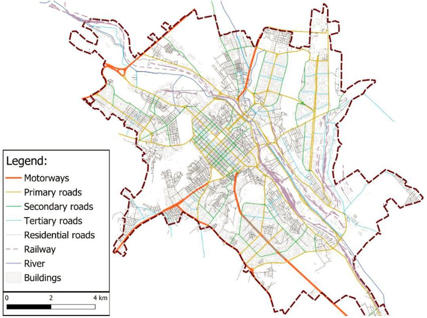
Sustainability 2021, 13, 3296                                                                                           2 of 16

                                the most important stakeholders. As the city’s inhabitants, citizens should also be involved
                                while the projects are being designed, implemented, and evaluated. In [4], Angelidou, M.
                                notes that stakeholders should share their needs with governments, and that it is important
                                to include experts from various fields while planning smart city strategies and adapt the
                                strategies to local contexts.
                                     In another paper [5], Angelidou, M. points out the importance of taking into account
                                both technology (digital intelligence) and knowledge (smart intelligence) to help with the
                                realization of smart cities and further urban development, which many strategies fail to do.
                                According to her research, demand-driven solutions are more effective than supply-driven
                                solutions in smart cities. A smart city strategy should try to meet the needs of citizens.
                                She states that raising citizens awareness, improving their skills with technologies, and
                                providing access to them is essential [4].
                                     Currently, there seems to be a vacuum of scientific findings in detailing how to
                                cope with long distance strategy preparation under the influence of the COVID-19 crisis.
                                However, some interesting research about the influence of the current crisis on mobility
                                has been done. Researchers have suggested possible directions in urban and mobility
                                planning based on lessons learned during the pandemic. The mode choice in many cities
                                has changed during the pandemic. There was an increase in car use and decrease in
                                traveling by public transport [6–10].
                                     Campisi et al. [6] focused on the influence of COVID-19 on the resilience of sustainable
                                mobility in Sicily. The authors used a questionnaire, undertaken in spring 2020, to compare
                                the travel behavior of people before and during the pandemic. People liked the idea of
                                using micro-mobility during the pandemic. According to the authors, this can be seen as
                                useful information to create sustainable urban plans and a motivation for decision-makers
                                who promote the use of walking, cycling, micro-mobility, and public transport. They also
                                mentioned that bicycles should be an alternative, particularly in less densely populated
                                parts of the towns, and that the space that was originally meant to be used for transit and
                                the parking of cars can be used for cycling. There are many ways to repurpose parking
                                spaces that occupy public space. Giving them back to people is only one variant.
                                     Özden et al. [8] reported similar findings. The authors used data by Apple Inc.
                                (Cupertino, CA, USA) and Google Inc. (Menlo Park, CA, USA), which provided data such
                                as driving and walking trends and daily location access trends from three time periods:
                                before the pandemic, during temporary lockdowns, and normalization. They suggest
                                turning the current crisis into an opportunity, by making strategic plans to improve the
                                infrastructure for cyclists and pedestrians. People are using micro-mobility more than
                                ever before, and the reduced demand for public transport is expected to remain low for
                                some time (due to sanitary issues and fear of contamination). The authors also recommend
                                improving the connectivity of transit stations and P+R (park and ride) lots to attain a proper
                                level of the sustainability and resiliency of mobility.
                                     As with other study, in a recent Italian paper (Barbarossa, L.) [7], the improvement
                                of cycling and walking infrastructure is also recommended. The authors mention that
                                due to the need of social distancing, public transport systems are not able to run at full
                                capacity. Thus, public transport might not be in competition with private cars. However,
                                increased usage of private cars can lead to an increase in air pollution. In their research,
                                they found that many cities around the world are adopting the following measures: widen-
                                ing pavements that are close to parks, schools, and shops, removing motor traffic from
                                residential areas, and building safe cycling routes to offices, schools, and close to main
                                roads (by closing unnecessary roads and squares to motorized traffic). All of this is to
                                support sustainable mobility (cycling and walking). As an example, the article states
                                that Paris plans to make amenities reachable within a 15 min non-motorized trip for its
                                residents; London plans to build new cycling and walking routes next to major roads; and
                                Mexico City plans to build new bike paths in order to encourage people to stay away from
                                public transport.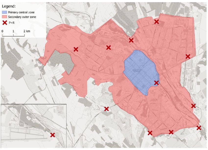
Sustainability 2021, 13, 3296                                                                                            3 of 16

                                     Combs et al. [11] noticed worldwide measurements such as carving out roadway
                                space for pedestrian and cyclists or reducing speed limits. Basu et al. [9] added that a
                                multi-modal approach will be needed to ensure affordable and sustainable urban mobility.
                                     In the paper from González-Sánchez et al. [12], recommendations for making effective
                                policy decisions based on SWOT analysis (Strengths, Weaknesses, Opportunities and
                                Threats) to address the situation after the pandemic were suggested. They focused on
                                sustainable mobility and gender equality. In total, they created 16 strategies. For our paper,
                                the most relevant seem to be facilitating public transport with bicycles or personal mobility
                                vehicles, improving the safety of public transport and restoring confidence, redistribution
                                of public space to prefer active mobility, and lowering the number of lanes for private cars,
                                speed and parking.
                                     In summary, scientists from various regions recommend supporting micro-mobility
                                (bicycles, scooters, motorcycles) and walking infrastructure in order to offer alternative
                                transportation modes to cars, while enabling the maintaining of social distancing in the
                                future. This provides an interesting view over some troublesome areas, which are described
                                below as parking and public transport. While it is necessary to still focus on the overall
                                improvement and changed approach to these areas, it is also necessary to consider the
                                recent findings and always support micro-mobility.
                                     As described above, many cities currently face the need to redevelop their infrastruc-
                                ture to be able to compete globally. To reach that, it is necessary to maintain or enhance
                                the quality of life by improving city services and resources [13]. The city of Chis, inău
                                is no exception.
                                     While the project itself was aimed at analysis of the current state of transport and
                                mobility in Chis, inău city, and after that, recommendation of particular measures, the paper
                                shall explore the chosen approach, most important findings and their respective measures,
                                and the added value of cooperation. All steps of document creation need to be discussed,
                                so that the main goal of the paper can be reached.
                                     To see to the specific needs of the city of Chis, inău (or rather, the Republic of Moldova)
                                four main areas of expertise with respect to mobility have been defined. These have
                                been visualized in the horizontal decomposition in the figure below (Figure 1): Traffic in
                                motion, Parking, Public transport, and Active mobility (walking, cycling, other means of
                                micro-mobility). The municipality gives the greatest heed to parking and public transport,
                                and rightfully so. Even though the document formally distinguishes four main areas
                                of expertise, there always needs to be a certain level of overlap into other fields (such
                                as urbanism, healthcare/emergency services, etc.). The vertical decomposition follows
                                frequently used and agreed upon structures of strategic documents (the intention was to
                                define problems through thorough analysis and communication) and propose solutions
                                that follow a simple vision.
                                     Perhaps the most important premise to mention is that the effort does not end with
                                this project. Moreover, the work is not finished by the completion of the document. While
                                in theory this might seem rather obvious, in many cases, municipalities tend to cease their
                                efforts after a document has been created, even though this is when the actual work starts.
                                With no follow-up, there is no reason to invest energy into strategic document projects.
                                The working team bases their estimates on the idea of a cyclic approach to city planning,
                                as shown in Figure 2. In this approach, the implementation phase is both the end of the
                                project and the beginning. Any public project that hopes to be successful must not fail to
                                include all necessary stakeholders.
                                     The goal of the article is to assess whether it is possible to create a well-received
                                strategic document (in this case, a smart mobility strategy) while the effects of the global
                                pandemic caused by COVID-19 change the known factors and force the team to work
                                from abroad, rendering them unable to visit the site. Initially, the project was to include
                                multiple trips to the Republic of Moldova (the teams is from Czech Republic—part of
                                a UNDP project aimed at the transfer of knowledge). However, due to the effect of the
                                above-mentioned global crisis, it was not possible to visit the country. The only means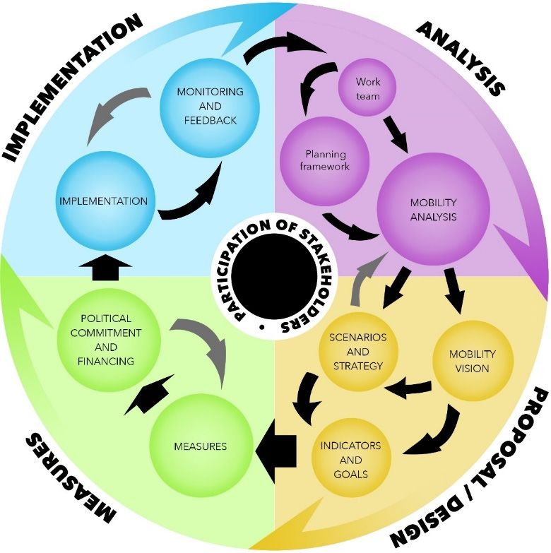
Sustainability 2021, 13, 3296 4 of 16
available were online meetings and communication and the analysis of available data.
Sustainability 2021, 13, x FOR PEER Unsupervised,
REVIEW no other measurements and surveys could take place. Fortunately, the4 city
of 17
already had several interesting datasets.
Figure1.1.Structure
Figure Structureofofthe
thedocument
document[14].
[14].
Perhaps thethe
Throughout most
work important premise
on the strategic to mention
document, theisteam
thatdevoted
the effort does notamounts
significant end with
ofthis project.
energy onMoreover,
researching thethe
work is notoffinished
matter by the completion
the degrading condition of the document.
effects While
to the project.
in theory no
However, thisscientific
might seem rather
articles orobvious, in many
other papers were cases,
found municipalities
which couldtend helptothe
cease their
teams
efforts after a document has been created, even though this is when
work through the problems that arose. Therefore, the team was forced to create their own the actual work starts.
With no follow-up,
methodological approachthereon is how
no reason
to dealtowith
investsuch energy into strategic
conditions. document
Everything is basedprojects.
on a
The working team
straightforward bases their estimates on the idea of a cyclic approach to city planning,
hypothesis.
as shown in Figure
Procedure: 2. In this
to counter theapproach,
effect of thetheglobal
implementation phase is both the
crisis (pandemic-related end of of
measures the
COVID-19),
project andsuch as forced work
the beginning. Any from
publicabroad
projectand thatthe inability
hopes to betosuccessful
physicallymustvisitnot
thefail
site,to
existing
includedata sources were
all necessary chosen to be a determining factor in weakness identification
stakeholders.
and section prioritization.
The goal of the article is to assess whether it is possible to create a well-received stra-
tegic document (in this case, a smart mobility strategy) while the effects of the global pan-
Hypothesis
demic caused 1. Using data from change
by COVID-19 traffic flow
the volumes providedand
known factors by the police,
force the the
teamdata
to of accident
work from
rates, datarendering
abroad, about queue them creation
unableandto communication with stakeholders
visit the site. Initially, the projectare enough
was to properly
to include multi-
identify priority
ple trips to theareas of expertise
Republic within Smart
of Moldova Mobility.
(the teams is from Czech Republic—part of a UNDP
project aimed at the transfer of knowledge). However, due to the effect of the above-men-
To confirm
tioned or disprove
global crisis, it was notthispossible
hypothesis, thisthe
to visit article will cover
country. The onlyhow the data
means and other
available were
sources of information were analyzed, and what was found after additional
online meetings and communication and the analysis of available data. Unsupervised, no communication
with
otherthemeasurements
city and stakeholders. There
and surveys was take
could also an additional
place. hypothesis
Fortunately, made
the city by the
already team
had sev-
when working on the
eral interesting datasets. initial hypothesis. The second hypothesis will be referred to later in
this work as a Hypothesis
Throughout the work 2. on the strategic document, the team devoted significant
amounts of energy on researching the matter of the degrading condition effects to the
Hypothesis 2. The city of Chis, inău is made for cars, not for the people, lacking an
project. However, no scientific articles or other papers were found which could help the
anthropocentric approach.
teams work through the problems that arose. Therefore, the team was forced to create
their own methodological approach on how to deal with such conditions. Everything is
based on a straightforward hypothesis.
Sustainability 2021, 13, 3296                                                                                                           5 of 16

nability 2021, 13, x FOR PEER REVIEW               Proving this hypothesis is possible through the same approach 5asofproving
                                                                                                                       17     the first
                                               hypothesis, with data analysis.

                               Figure 2. Strategic document life cycle [14].
                                                         Figure 2. Strategic document life cycle [14].

                                     Procedure: to counter the effect of the global crisis (pandemic-related measures of
                               COVID-19), such  2. Methods
                                                     as forced work from abroad and the inability to physically visit the site,
                               existing data sources  Thewere    chosen
                                                           structure    andto approach
                                                                               be a determining
                                                                                         chosen forfactor
                                                                                                      thisinproject
                                                                                                              weakness
                                                                                                                     wereidentification
                                                                                                                           the same as in numerous
                               and section prioritization.
                                                strategic documents throughout Europe and Czech Republic to further the transfer of
                                                knowledge (an important aspect of the cooperation). Cooperation with other cities and
                               Hypothesis 1.experience
                                                  Using dataandfromknowledge
                                                                     traffic flow exchange
                                                                                  volumes provided   by theinpolice,
                                                                                             is a practice    smartthe   data
                                                                                                                      city    of accident
                                                                                                                           strategies  of existing cities
                               rates, data aboutwith
                                                  queue  creation andcharacteristics
                                                      international    communication[4]. with stakeholders are enough to properly iden-
                               tify priority areas of The
                                                      expertise
                                                           whole within  Smart
                                                                    chosen       Mobility.
                                                                             process is systematic in its nature and can be summarized in several
                                                steps, as follows:
                                     To confirm or disprove this hypothesis, this article will cover how the data and other
                                                -     Communication with stakeholders;
                               sources of information
                                                -          wereanalysis
                                                      Detailed     analyzed,    and whatdata;
                                                                            of available   was found after additional communica-
                               tion with the city
                                                -   and   stakeholders.     There  was  also
                                                      Defining vision and strategic goals;   an additional hypothesis made by the
                               team when working-     Describing individual measures. second hypothesis will be referred to
                                                         on  the  initial hypothesis.   The
                               later in this work as a Hypothesis 2.
                                                      The fundamental idea is to define the problem based on thorough communication and
                                                detailed analysis, subsequently agreeing on a common goal to support (vision) and finally
                               Hypothesis 2. The city of Chișinău is made for cars, not for the people, lacking an anthropocentric
                                                to reach the goal through individual measures (sorted into strategic goals that follow similar
                               approach.

                                   Proving this hypothesis is possible through the same approach as proving the first
                               hypothesis, with data analysis.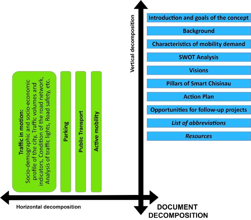
Sustainability 2021, 13, 3296                                                                                                          6 of 16

                                              division as the analytical part does). The approach has firm roots in new European Sustain-
                                              able Urban Mobility Plan methodology—aka SUMP 2.0 [15] (CIVITAS SUMPs-Up, 2020).
                                                    For the chosen approach, or methodology, to counter the effects of the COVID-19
                                              pandemic, see Figure 3. There are two main changes to be made: (i) the communication is
                                              needed to be given greater heed, because the visit and personal discussion were canceled;
bility 2021, 13, x FOR PEER REVIEW            (ii) because no additional data could be collected by the team (and no   surveys
                                                                                                                     7 of 17   could take
                                              place), it was necessary to carefully chose which data to work with.

                             Figure 3. Hypothesis and methodological
                                                   Figure            approach.
                                                          3. Hypothesis and methodological approach.

                             2.1. Communication with
                                                   The Stakeholders
                                                        reasoning behind this methodology was based on the size of the city and the
                                   Proper communication is theConducting
                                             current  situation.     very basis ofany    large-scale
                                                                                     proper            survey over
                                                                                              understanding           a long distance
                                                                                                                 of a subject at hand. was out of the
                                             scope   and  nullified.   A  city of  this  magnitude     needed   to
                             The authors of the document were from a foreign country and initial visits were made  be  described   through hard data
                             impossible duecombined
                                               to COVID-19withrelated
                                                                 clear communication.
                                                                          restrictions; therefore, a proper mode of communi-
                             cation needed to be The    first step
                                                   arranged.        was
                                                                In the     the communication
                                                                        figure  below (Figure 4),with     stakeholders
                                                                                                      a map                (See Section
                                                                                                              of stakeholders    can be 2.1), then the
                             seen. These aredata   analysis
                                              the same        wasand
                                                         entities   performed      (Section
                                                                         institutions         2.2), creating
                                                                                        that would            heatmaps
                                                                                                      be consulted         of road
                                                                                                                      in person;    infrastructure, ac-
                                                                                                                                  how-
                                             cidents,  and   traffic flows    volumes.    The   research   team   expected
                             ever, due to the above-mentioned difficulties, these had to be “visited” in a virtual envi-     that  by watching traffic
                                             flow  and   traffic  jams,  the  most   problematic     locations
                             ronment. To compensate for the long-distance communication and diminish the impact will  be  found.  Afterwards,   a sum-
                                             mary   of weaknesses      was    conducted     through    the SWOT     analysis.
                             of not being able to visit the site personally, the communication was made more frequent           This was  followed  by
                                             the  creation  of  a  vision   (Section  2.3)  and  suggestion    of  measures
                             and longer to cover all important aspects. This was all made possible by the unyielding           to address  discovered
                             effort of the teams in the Czech Republic and in the Republic of Moldova. Through this
                             thorough communication, all necessary topics were covered.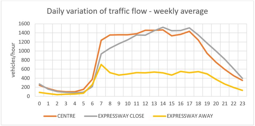
Sustainability 2021, 13, 3296 7 of 16
problems (Section 2.4). Again, the findings needed to be properly communicated with the
stakeholders and the city. This step would confirm or reject the hypothesis.
2.1. Communication with Stakeholders
Proper communication is the very basis of proper understanding of a subject at hand.
The authors of the document were from a foreign country and initial visits were made im-
possible due to COVID-19 related restrictions; therefore, a proper mode of communication
needed to be arranged. In the figure below (Figure 4), a map of stakeholders can be seen.
These are the same entities and institutions that would be consulted in person; however,
due to the above-mentioned difficulties, these had to be “visited” in a virtual environment.
To compensate for the long-distance communication and diminish the impact of not being
able to visit the site personally, the communication was made more frequent and longer
to cover all important aspects. This was all made possible by the unyielding effort of the
teams in the Czech Republic and in the Republic of Moldova. Through this thorough
ability 2021, 13, x FOR PEER REVIEW 8 of 17
communication, all necessary topics were covered.
Figure 4. Map of stakeholders [14].
Figure 4. Map of stakeholders [14].
2.2. Data Analysis
2.2. Data Analysis
The first step ofThe first step
analysis wasofcompleted
analysis was completed
through through
analytical workanalytical
with map work
data.with
Thismap data. This
step the
step can be called canmapping
be called phase.
the mapping
In this phase.
case, the Inmost
this case, the most
prominent andprominent
useful data and useful data
source was OpenStreetMap
source was OpenStreetMap data availabledata available
in GIS in GIS (Geographic
(Geographic InformationInformation
System) for- System) formats
mats and applications. This gave the project, or rather the city, a tangible scope for thefor the team to
and applications. This gave the project, or rather the city, a tangible scope
focus
team to focus on. on. It allowed
It allowed the authors
the authors to experience
to experience the spatial
the spatial dimensions
dimensions and and understand what
under-
stand what thethe terrain
terrain and and urbanistic
urbanistic structure
structure looked
looked likelike
andandhowhow they
they might
might affect
affect thethe day-to-day
day-to-day lifelife of residents
of residents and
and visitors.
visitors. InIn Figure5,5,there
Figure thereisisthe
thevisualization
visualizationof ofthe
the road
road infrastructure
infrastructure in
in the
the city
city of
ofChis , inău. The
Chișinău. Thelocation
locationof ofvarious
variouspoints
pointsofofinterest
interest(such
(suchasasfrequent traffic
jams, data collectors, etc.) were then added through
frequent traffic jams, data collectors, etc.) were then added through communication communication with
withstakeholders.
stakeholders. After the city was mapped, then came the collection of other data sources (e.g., socio-
demographic and socio-economic data, heat-maps from Strava
After the city was mapped, then came the collection of other data sources (e.g., socio- [16], data collection points,
data of road accidents, etc.). The visualization of heat-maps
demographic and socio-economic data, heat-maps from Strava [16], data collection points, accidents can be found in
Figure 6.etc.).
data of road accidents, All the
Thedatasets were provided
visualization of heat-maps by the municipality,
accidents can bemunicipality
found in Fig-institutions, or
by stakeholders.
ure 6. All the datasets were provided by the municipality, municipality institutions, or by
stakeholders. Traffic flow volume data proved to be the most interesting (analysis-wise), because it
provided a number of opportunities and ways to analyze the traffic in Chis, inău utilizing this
data. The possible visualization is displayed in the figures below (Figure 7 and Figure 8).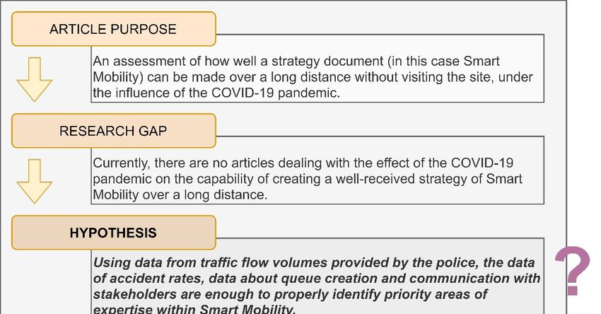
frequent traffic jams, data collectors, etc.) were then added through communication with
stakeholders.
After the city was mapped, then came the collection of other data sources (e.g., socio-
demographic and socio-economic data, heat-maps from Strava [16], data collection points,
Sustainability 2021, 13,data
3296 of road accidents, etc.). The visualization of heat-maps accidents can be found in Fig- 8 of 16
ure 6. All the datasets were provided by the municipality, municipality institutions, or by
stakeholders.
ability 2021, 13, x FOR PEER REVIEW 9 of 17
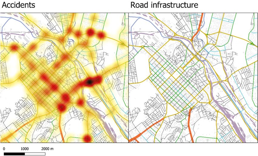
Figure 5. Map of road infrastructure (OpenStreetMap data) [17].
Figure 5. Map of road infrastructure (OpenStreetMap data) [17].
Figure
Figure 6. Map of6.accidents
Map of accidents
and road and road infrastructure
infrastructure in the in thecenter
city city center
(Chis(Chișinău Police and Open-
, inău Police and OpenStreetMap data,
StreetMap
respectively) [17]. data, respectively) [17].
Traffic flow volume data proved to be the most interesting (analysis-wise), because
it provided a number of opportunities and ways to analyze the traffic in Chișinău utilizing
this data. The possible visualization is displayed in the figures below (Figures 7 and 8).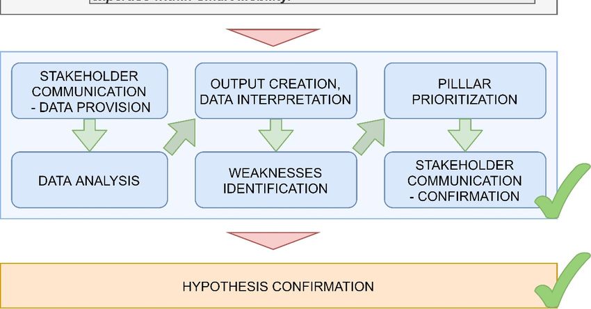
Figure 6. Map of accidents and road infrastructure in the city center (Chișinău Police and Open-
                             StreetMap data, respectively) [17].

                                     Traffic
          Sustainability 2021, 13, 3296   flow volume data proved to be the most interesting (analysis-wise), because                                 9 of 16
                             it provided a number of opportunities and ways to analyze the traffic in Chișinău utilizing
                             this data. The possible visualization is displayed in the figures below (Figures 7 and 8).

ability 2021, 13, x FOR PEER REVIEW
                             Figure 7. Map of traffic flow volumes in the city (data from automated traffic counters) [17].10 of 17
                                Figure 7. Map of traffic flow volumes in the city (data from automated traffic counters) [17].

                             Figure 8. Graph traffic flow volumes in the city (data from automated traffic counters) [17].
                                Figure 8. Graph traffic flow volumes in the city (data from automated traffic counters) [17].

                                  Combining theCombining
                                                      data with the thelocation
                                                                         data with of the
                                                                                      frequent   traffic
                                                                                          location       jams (based
                                                                                                     of frequent         onjams
                                                                                                                    traffic local(based
                                                                                                                                    experi-on local experi-
                             ence) and the utilization     of Greenshield’s      model—the      mathematical      relationship    between
                                              ence) and the utilization of Greenshield’s model—the mathematical relationship between
                             velocity, trafficvelocity,
                                                density traffic
                                                          and traffic    flow
                                                                   density      volumes
                                                                              and          [18,19]—allowed
                                                                                   traffic flow                   the team to properly
                                                                                                  volumes [18,19]—allowed           the team to properly
                             assess the stateassess
                                               of road   traffic in  the  city. The  cumulation     of traffic
                                                       the state of road traffic in the city. The cumulation ofjams,  parts  of the
                                                                                                                         traffic jams,infra-
                                                                                                                                         parts of the infras-
                             structure with high     traffic
                                              tructure   withflow
                                                                highvolumes,    andvolumes,
                                                                      traffic flow    the geometrical
                                                                                                and the properties
                                                                                                          geometricalofproperties
                                                                                                                          the infrastruc-
                                                                                                                                       of the infrastructure
                             ture itself provided
                                              itself enough
                                                     provided  insight
                                                                  enough to confirm
                                                                             insight toHypothesis    2 of a city made
                                                                                         confirm Hypothesis               mostly
                                                                                                                  2 of a city  madeformostly
                                                                                                                                        cars for cars and
                             and not peoplenot  (this  being(this
                                                   people      onebeing
                                                                     of theonefundamental     errors that
                                                                                of the fundamental          thethat
                                                                                                        errors   vastthe
                                                                                                                       majority    of cities
                                                                                                                          vast majority    of cities made in
                             made in the past theand
                                                   pastare only
                                                         and   arenow
                                                                    onlyaddressing).
                                                                          now addressing).

                             2.3. Vision
                                  The vision determines the main direction, or rather, the destination, that the political
                             representation of the city wishes to reach in its long-term development and urban plan-
                             ning. It sets boundaries for individual measures and gives context.

                             2.4. Measures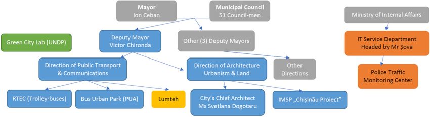
Sustainability 2021, 13, 3296                                                                                            10 of 16

                                2.3. Vision
                                      The vision determines the main direction, or rather, the destination, that the political
                                representation of the city wishes to reach in its long-term development and urban planning.
                                It sets boundaries for individual measures and gives context.

                                2.4. Measures
                                     The measures were divided among strategic goals or subchapters, all in support of the
                                main vision. Although all measures (and all strategic goals) should be equally important
                                in the long-term planning, it is understandable that there is a certain level of priority in
                                short-term planning. For instance, the two main areas of expertise that are discussed in
                                this paper (parking and public transport) are the imminent threats to sustainable mobility,
                                because they are believed to be the core problems to the population.

                                3. Analysis of Existing Problems in the City of Chis, inău
                                     This chapter describes problems found in the city of Chis, inău during the project.
                                While there are several insufficiencies and possible problems, two areas of expertise stand
                                out as the greatest opportunities for change and improvement. These two areas are parking
                                and public transport.

                                3.1. Parking
                                      The main problem with parking in the city of Chis, inău is that it is free and unregulated.
                                It is even possible to park on the sidewalk and in the green areas. This, in addition to
                                problems with the public transport (further described in the next chapter), leads to massive
                                use of cars which has environmental and other consequences.
                                      However, the problem is more robust. The car user is seen as the obvious customer
                                when planning further development. Individuals are starting to notice that there are simply
                                too many cars and too little space. Dedicated parking spaces are outdated and inefficient,
                                meaning no one can always have a guaranteed parking spot, requiring parking to be
                                severely regulated and digitized.
                                      It was discovered that the demand for short-term parking (up to 150 min) is about
                                ten-fold higher than the demand for longer parking [20]. This also poses a problem because
                                there are fewer parking spaces left for local inhabitants who encounter difficulties finding
                                a parking spot. It is apparent that many cars are parked illegally, for example on the
                                pavement, which further degrades the public space and restricts pedestrian movement.
                                      Another problem, in this case with solving the parking issues in the city, is the lack of
                                norms. Moldovan norms on road construction and traffic regulation do not mention the
                                dimensions of a parking space. This makes it harder for the experts to solve these problems.
                                There are no given legislative requirements for a parking space; therefore, any design could
                                be denied if the concept of parking regulation is disputed.

                                3.2. Public Transport
                                      The main problem of the public transport is that there is no integration. There are, in
                                fact, three separate transport systems. One of them is railway transport, the second one is
                                transport organized by a municipal company, which consists of buses and trolleybuses,
                                and the third one is minibus transport (marshrutkas).
                                      Although Chis, inău has a good accessibility of public transport stops, and 90% of the
                                area is theoretically in quite a short walking distance to a public transport stop (250 m
                                in the city center and 500 m in other parts of the city), actual walking distances can be
                                longer. This can be due to long intervals at some stops. The situation induced is that it may
                                actually be faster for the passenger to walk to a farther stop that has more frequent public
                                transport service.
                                      The trolleybus network measures 285 km, which makes it one of the densest trolleybus
                                networks in the world (in relation to the size of the city). However, the infrastructure is
                                outdated. Although the investments in the new vehicles have started, about one-third
Sustainability 2021, 13, 3296 11 of 16
of the vehicles are over the age of ten years. In 2019, the trolleybuses transported about
17.4 million passengers on 31 lines.
The bus network consists of 23 bus lines, of which 18 are suburban. Both buses and
trolleybuses are available in both standard and articulated versions. The buses carried
about 145 million passengers in 2019, which is about 400,000 passengers per day. Given
that there are 127 bus vehicles in circulation in Chis, inău, this means every bus carries
3150 passengers per day on average, which is about 50 journeys per day, at full capacity,
every day. The vehicles are generally very crowded. The bus vehicle fleet is quite obsolete.
and the average age of the vehicles is 14 years.
Apart from the buses and trolleybuses, there are also 43 lines (of which 23 are sub-
urban) of minibuses (marshrutkas) with 743 vehicles in service. These vehicles are even
older than the buses; the average age of the minibuses is 18.5 years. With a capacity of
15 passengers per vehicle, it is questionable whether this transport mode is suitable in a
large city, such as Chis, inău. It may be needed to transform this system to a more suitable
mode of transport in the future.
The city of Chis, inău has over 500,000 inhabitants and the share of public transport
in transport performance is estimated to be about 60%; therefore, it is recommended for a
tram or railway system to be the backbone of public transport. The existing railway system
appears to be suitable for this purpose, it just needs to be integrated in the city’s public
transport system.
Additional problems with the public transport lie in punctuality, the regularity of
service, and the fare system. Every line has its own interval of service, which is based on
both the demand for transport and cruising time of the line. Thus, every line has its own
intervals, independent of other lines. This leads to other various problems, especially for
the passengers. The punctuality of the public transport vehicles is monitored using the
GPS system, however there is no set standard for transport punctuality. The punctuality is
affected by the poor technical conditions of both the vehicle fleet and the infrastructure.
The fare is combined within the transport system, based on distance traveled and number
of journeys. The price of single ride tickets is so low that people are not encouraged to buy
a subscription ticket; currently, only about 1.5% of riders use these.
All data above are taken from the analytical part of the Smart Transport and Mobility
Strategy and Action Plan for Chis, inău City [17].
4. Examples of Using the Methods/Measures
Not only are parking and public transport the most prominent among the areas of
expertise, but these also need to be seen as two systems that work best when they co-exist
symbiotically. These should be extensions of one another and should not be seen as compet-
ing systems [21]. An important aspect of determining whether the chosen methodology for
specifying the priority areas was to not only discuss this with the stakeholders, but also to
choose suitable measures, that could counter the problems and identifying these measures
(at least partially) could be implemented within a shorter timeframe (within five years).
4.1. Parking
The problem lies in how the people understand (or rather misunderstand) the place
of the car in public space; therefore, adding extra capacity will not solve the problem, it
would simply postpone it. Additional capacity is only a panacea when accompanied by
additional steps.
The solution itself can be simplified into three parts: zone creation (including pricing
policy), digitization, and P+R utilization. The creation of zones (see Figure 9) gives the
police and administration a simple-to-define and simple-to-use tool for regulation. It also
enables simple city-wide changes in pricing policy (benefiting the residents and restricting
visitors in the center). The change from non-regulated free parking to city-wide zones will
be the most difficult change to accept if not communicated properly. Digitization allows
for simple management, enforcement and user experience (it might seem overly regulatedSustainability 2021, 13, 3296 12 of 16
at first, but in the end, this benefits both the city and the citizens). Lastly, P+R parking
(if placed logically) will allow commuters to leave their cars on the edge of the city and
transfer to public transport (this creates the greatest cooperation between the two systems).
Sustainability 2021, 13, x FOR PEER The
REVIEW
unifying component is proper parking management, which can be reached through 13 of 17
several measures, that are not necessarily budgetarily intense.
Figure9.9.Parking
Figure Parkingzones
zonesand
andpark
parkand
andride
ride(P+R)
(P+R)placement
placementmap
map[22].
[22].
4.2. A rough
Public summary can be that people unfortunately cannot park wherever and when-
Transport
ever they
In order they
like; needan
to create to efficient
understand the restrictions
transport system, tothat come
solve thewith limitedofspace.
problems all its The
indi-
public space should belong to the people, not to their cars.
vidual components and combine them into one coordinated system, an integrated
transport system (ITS) is needed. The integration process consists of the appointment of
4.2. Public Transport
an ITS coordinator who will manage and fund the public transport service, while the
In order
transport to create an
companies efficient
will transportthe
only maintain system,
publictotransport
solve the operation.
problems ofThe all its individ-
coordinator
ual components and combine them into one coordinated system, an integrated
will also elaborate the ITS quality standards and methodology of their implementation transport
system (ITS) is needed. The integration process consists of the appointment of an ITS
and the strategy documents. ITS also includes the construction and modernization of rail-
coordinator who will manage and fund the public transport service, while the transport
way infrastructure, together with the construction of multimodal changes near the most
companies will only maintain the public transport operation. The coordinator will also
important train stops.
elaborate the ITS quality standards and methodology of their implementation and the
In order to make the system work as intended, it is needed to include all modes of
strategy documents. ITS also includes the construction and modernization of railway in-
transport into the system, including trains, and coordinate them. Including the trains in
frastructure, together with the construction of multimodal changes near the most important
the system brings a significant increase in transport capacity and cruising speed, which
train stops.
helps the public transport compete against individual car transport.
In order to make the system work as intended, it is needed to include all modes of
The next improvement should be the optimization of inter-stop distances in the pub-
transport into the system, including trains, and coordinate them. Including the trains in
lic transport network. Truncated distances cause vehicles to stop too often, and therefore
the system brings a significant increase in transport capacity and cruising speed, which
slow down the public transport. On the other hand, extended inter-stop distances cause
helps the public transport compete against individual car transport.
lengthened
The nextwalking distances;
improvement shouldtherefore, some peopleofmay
be the optimization opt fordistances
inter-stop using a incartheinstead
publicof
the public transport. Another means of raising the cruising speed of the
transport network. Truncated distances cause vehicles to stop too often, and therefore public transport
is the
slow prioritization
down the publicortransport.
preference Onofthe
public
othertransport. That means
hand, extended elaborating
inter-stop distances a strategy
cause
for public transport prioritization development with emphasis on
lengthened walking distances; therefore, some people may opt for using a car instead of comprehensive
transport
the solutions. Another means of raising the cruising speed of the public transport
public transport.
An integrated
is the prioritization or transport system
preference also includes
of public quality
transport. Thatcontrol,
meansi.e., standardsa for
elaborating the
strat-
punctuality of operation. These should be developed and include an acceptable deviation
from the timetable by the level of demanding character. For example, the integrated
transport system in Prague demands that at least 80% of the tram connections are delayed,
at most, by 3 min [23]. Deviations from the timetable should be continuously monitoredSustainability 2021, 13, 3296 13 of 16
egy for public transport prioritization development with emphasis on comprehensive
transport solutions.
An integrated transport system also includes quality control, i.e., standards for the
punctuality of operation. These should be developed and include an acceptable deviation
from the timetable by the level of demanding character. For example, the integrated
transport system in Prague demands that at least 80% of the tram connections are delayed,
at most, by 3 min [23]. Deviations from the timetable should be continuously monitored
and analyzed.
The final part of the integrated transport system is the fare system. The fare should be
uniform, based on the number of stops, on distance, or a combination of these, regardless
of carrier or transport mode used. One ticket should be valid in all means of transport
of all carriers. All tickets, even short-term ones, should be transferable. There should
be emphasis on subscription time fares, which are the best motivators for using public
transport. This all will massively increase the motivation of people to use public transport.
Furthermore, the fares should be gradually increasing in order to cover around 25% of the
operating costs.
5. Discussion
The presented procedure described in this article fully respects methodological ap-
proaches such as the Newcastle City Council Smart City Strategy 2017–2021 (Australia) [24].
However, unlike other methodologies, it differs in that it pays close attention to the an-
alytical part and is able to adapt to the specifics of transport planning in each European
city. The procedure is adapted to local conditions (especially as regards the delimitation
of the territory, preparation management structures and monitored data, etc.) and em-
phasizes the local context. It is also well in line with the latest utilized approaches in
the smart city, such as properly defined ontology in system hierarchy, the utilization of
agent-based systems, etc. [21,25–27], or more abstract smart city approaches, such as seeing
the information system and its similarities to quantum physics [28].
In this article, the main finding is based in the experience of working on a project
heavily influenced by the current global pandemic crisis while working from abroad. The
lack of some data, lack of on-site survey of the working team, and having to conduct all
interviews and communication solely through the digital environment have all put the team
through a test of how possible it is to reach the correct conclusion about the current state of
transport and mobility. While the project did provide a challenge for the team, in respect
to suboptimal conditions, the experience was, in truth, extremely important for future
projects, should some form of restrictions remain for an extended period. There is little to
no possibility to conduct such a project differently with our current knowledge base.
Finding no relevant research on this particular topic was a disappointment, because
there is no comparison for different approaches to such a task. The influences of the
global pandemic crisis, however, have been subjected to multiple research projects, that
did provide a lot of insight for the authors. For instance, the current dissatisfaction and
overall mistrust of public transport, that should, under normal circumstances, provide a
core transport system to any major city, does point towards micro-mobility-oriented trans-
portation systems. Hopefully, trust in the public transport will slowly return, and perhaps
this will be accompanied by major transformations in inter-modality and incorporation of
the first and last mile solutions into the current public transport systems [17,22].
The use of digital technologies to communicate have taken hold in our society at
the beginning of 2020, due to COVID-19, and made their way into almost all areas of
expertise, to include everyday life. Based on the experience from this project, it is likely
that a considerable percentage of foreign cooperation will move to the digital environment.
Whether this is good or bad will be revealed with time.
There is a substantial difference in culture and history between the Czech Republic
and the Republic of Moldova; as the data analysis showed, there is still prevailing love for
car ownership in the Republic of Moldova—proving the hypothesis (the initial hypothesis,Sustainability 2021, 13, 3296 14 of 16
defined by the team for the project) [17]. This is now beginning to change in Czech Republic.
However, there are also some similarities (it can be difficult to follow well thought-through
strategies if the ever-changing political representation cannot provide “quick win” solutions
along with the long-term planning, because the voters usually do not see that deep into
city planning. Just like the Czech Republic has a lot to gain from its neighbors, Germany
and Austria, in terms of sustainable mobility, there is a lot of potential for the Republic of
Moldova to draw from the same experience from the Czech Republic (because some of the
problems Moldova is facing right now, the Czech Republic has faced in the past as well).
Overall, most research focuses on the direct impact of the crisis to mobility in general.
While the lack of research directed at the topic at hand provided no further insights, the
relevant research on the impact to the mobility as a whole did put things into perspective
and was quite beneficial in respect to having a broader understanding of the influence of
the global pandemic. It did not help the team with finding out how it affected the creation
of strategic documents. In this project, perhaps the most interesting thing is that the team
managed to create a very precise analysis of the current state with no direct contact with
the city.
It is necessary to point out that the smart city and smart mobility, etc., should not be
considered solely for bigger cities (capital cities or other regional cities with hundreds of
thousands or even millions of citizens); it should be possible to utilize basic findings even
for smaller cities and villages. This research, however, focuses on an experience based
on a project for the capital city of the Republic of Moldova, the city of Chis, inău (around
640,000 citizens). While the findings should be relevant for similar cities, it is doubtful that
it can be used for any city, town, or village, regardless of the size. Further research should
be conducted that considers differently sized cities, possibly enabling a meta-analysis.
Further research for multiple areas of expertise, different environments, and different
sizes of cities should provide enough data for meta-analysis, helping to provide more
certainty into how to create a strategy under the influence of a global pandemic while
working from abroad. Some experiences are not transferable, and one study does not
cover all possibilities. Some experiences, however, are transferable, such as those regarding
communications with officials. While the current crisis may (hopefully) end soon, others
might follow in the future, and we should be prepared.
6. Conclusions and Recommendation
To conclude, the first hypothesis for this article was proved; the analyzed data allowed
the team to specify what should be a priority. This was later confirmed by the municipality
to be indeed the case. Data allowed for problem formulation, that pointed to two areas of
expertise: parking and public transport [17,22]. Not only are parking and public transport
seen by the municipality as most important, but they are also the most challenging to truly
solve, because some steps can involve greater opposition from users if not communicated
properly. They do, however, not necessarily need to be expensive, as opposed to some
costly infrastructural changes. Most of the measures in these two areas can be described
as organizational. Although the hypothesis was proved, it should be emphasized that
multiple visits to the site should be always included in such projects, if the situation allows.
However, if the situation proves more challenging, it certainly is possible to conduct the
work virtually, in the sense of not being present.
The hardest challenge to overcome was indeed the limitations of the crisis caused by
the COVID-19 pandemic. However, a quick replanning took place, and the result was very
promising in the end. The outputs of the analysis and prioritization proved to be most
beneficial to the municipality, because they are now able to be drawn from the findings.
The premise of the project has always been foreign cooperation. Therefore, it was always
known that most of the work would be conducted from abroad with limited journeys to
the city. An advantage can be seen in 100% of work being done from abroad, that every
key person was very keen and prepared to react and offer any assistance. Additionally, in
future, expenses can be cut by removing the travel fees, because everyone was very awareSustainability 2021, 13, 3296 15 of 16
of what inactivity in these worsened conditions could bring. In contrast, not seeing the city
first-hand could have created a crooked idea of what problems the city is actually facing
(this is the reason why stakeholder confirmation was necessary).
The proactive approach from the city representatives was a refreshing change and was
one of the main driving forces of this project, combined with the increased flexibility needed
from the authors. Everyone needed to deal with the changing circumstances of COVID-
19, and the way everything was managed allowed for the completion of this document
and important experience for both sides. The approach is unique because of COVID-19;
every single step of the creation of the presented strategy (such as communication with
stakeholders or the analysis of the current state), was done at a distance, because the
research team could not travel to Chis, inău due to the global pandemic.
The most important thing to do now is to never stop. In order to maintain pace
with other fast-growing cities, the updating of transportation networks should never stop.
Otherwise, the city will not attract people and ideas [29].
This document only provides a plan. Immediate implementation of short-term plans
and further development need to keep this idea alive. Not adhering to strategic documents
seems to be the weakness in Czech Republic, at times. Only time will tell if the city
of Chis, inău can work well enough with what they attained from the project. It is also
important to not be afraid to update the document if necessary. Provided that the end-goal
is visible and tangible, the journey can evolve. The upcoming months after the delivery
of the design part to the city of Chis, inău (aimed at implementation) should provide
opportunity for the team to visit the city and see everything first-hand (survey the city).
The most important aspect of these visits should be assessment, and whether these visits
change the opinion of the team on how they assessed the city problems from a long-
distance with the initial analysis. In other words, it provides an opportunity to compare
long-distance work and first-hand experience on the same city and the same project.
Author Contributions: All the authors mentioned above (R.D., J.K., A.M., K.M. and V.N.) contributed
equally to the research. All authors have read and agreed to the published version of the manuscript.
Funding: This research was funded by the United Nations Development Program (Moldova Sus-
tainable Green Cities—Catalyzing investment in sustainable green cities in the Republic of Moldova
using a holistic integrated urban planning approach), Project ID: 00101330. The project was executed
by SmartPlan s.r.o. in cooperation with the Faculty of Transportation Sciences at Czech Technical Uni-
versity in Prague based on institutional support for research institution development n. RVO16000.
The paper was supported by SmartPlan s.r.o.
Institutional Review Board Statement: Not applicable.
Informed Consent Statement: Not applicable.
Data Availability Statement: Used data can be found in the relevant references [14,17,22].
Acknowledgments: The work on the project “Smart Transport and Mobility Strategy and Action Plan
for Chis, inău City” followed by compilation of this paper was made possible through the partnership
with the Czech-UNDP Partnership for SDGs (hereafter CUP) project “Transfer of Czech experience
in the development and implementation of the Sustainable Urban Mobility Plan of the Chis, inău
Municipality” linked with the UNDP/GEF project “Moldova Sustainable Green Cities—Catalyzing
investment in sustainable green cities in the Republic of Moldova using a holistic integrated urban
planning approach” and a launched tool for this project, the Green City Lab (GCL). This partnership
is suitable and appreciated. The project was financed by UNDP supported by company SmartPlan, s.
r. o. and the Czech Technical University in Prague, Faculty of Transportation Sciences (CTU, FTS)
based on RVO—Institutional support for the development of research organization n. RVO16000
with J. Kocourek as the head of the team.
Conflicts of Interest: The authors declare no conflict of interest. The funders had no role in the design
of the study; in the collection, analyses, or interpretation of data; in the writing of the manuscript, or
in the decision to publish the results.Sustainability 2021, 13, 3296 16 of 16
References
1. Bízková, R.; Dostál, R.; Jaroš, V.; Jirman, P.; Kocourek, J.; Krčová, M.; Mlčák, L.; Nencková, L.; Vladyková, R.; Walletzký, S.; et al.
Strategický Rámec Svazu Měst a Obcí v Oblasti Smart City: Strategická Část; Svaz Měst a Obcí ČR: Prague, Czechia, 2020.
2. Angelidou, M. Smart city policies: A spatial approach. Cities 2014, 41, S3–S11. [CrossRef]
3. Gascó-Hernandez, M. Building a Smart City: Lessons from Barcelona. Commun. ACM 2018, 61, 50–57. [CrossRef]
4. Angelidou, M. The Role of Smart City Characteristics in the Plans of Fifteen Cities. J. Urban Technol. 2017, 24, 1–28. [CrossRef]
5. Angelidou, M. Smart cities: A conjuncture of four forces. Cities 2015, 47, 95–106. [CrossRef]
6. Campisi, T.; Basbas, S.; Skoufas, A.; Akgün, N.D.; Tesoriere, T.A.G. The Impact of COVID-19 Pandemic on the Resilience of
Sustainable Mobility in Sicily. Sustainability 2020, 12, 8829. [CrossRef]
7. Barbarossa, L. The Post Pandemic City: Challenges and Opportunities for a Non-Motorized Urban Environment An Overview of
Italian Cases. Sustainability 2020, 17, 7172.
8. Özden, A.; Şahin, S.N.A. Urban Mobility in Covid-19: How We Adapted to Change and How Should We Respond. Acad. Platf. J.
Nat. Hazards Disaster Manag. 2020, 1, 96–109.
9. Basu, R.; Ferreira, A.J. Sustainable mobility in auto-dominated Metro Boston: Challenges and opportunities post-COVID-19.
Transp. Policy 2021, 103, 197–210. [CrossRef]
10. Gkiotsalitis, K.; Cats, O. Public transport planning adaption under the COVID-19 pandemic crisis: Literature review of research
needs and directions. Transp. Rev. 2020, 1–9. [CrossRef]
11. Combs, T.S.; Pardo, C.F. Shifting streets COVID-19 mobility data: Findings from a global dataset and a research agenda for
transport planning and policy. Transp. Res. Interdiscip. Perspect. 2021, 9, 100322.
12. González-Sánchez, G.; Olmo-Sánchez, M.I.; Maeso-González, E. Challenges and Strategies for Post-COVID-19 Gender Equity and
Sustainable Mobility. Sustainability 2021, 13, 2510. [CrossRef]
13. Harrison, C.; Eckman, B.; Hamilton, R.; Hartswick, P.; Kalagnan, J. Foundations for smarter cities. IBM J. Res. Dev. 2010, 54, 1–16.
[CrossRef]
14. Smart Plan, s.r.o. Smart Transport and Mobility Strategy and Action Plan for Chis, inău City—Inception Report. 2020.
15. SUMPs-UP, C. POLI—Cities and Regions for Transport Innovation. 12 December 2019. Available online: https://www.polisnetwork.
eu/event/sump-2--0-reshaping-the-eu-sustainable-urban-mobility-planning-guidelines/ (accessed on 10 February 2021).
16. Strava, Inc. Strava Global Heatmap. Available online: https://www.strava.com/heatmap (accessed on 13 April 2020).
17. Smart Plan, s.r.o. Smart Transport and Mobility Strategy and Action Plan for Chis, inău City—Analytical Part. 2020.
18. Greenberg, H. An Analysis of Traffic Flow. Oper. Res. 1959, 7, 79–85. [CrossRef]
19. Underwood, R. Speed, Volume, and Density Relationship. Qual. Theory Traffic Flow. 1961. Available online: https://trid.trb.org/
view/115231 (accessed on 26 February 2021).
20. WSP Group. Chis, inău Urban Road Sector Project Parking System Support. 2013. Available online: https://www.
chisinau.md/public/files/anul_2014/strategii/Parking_Strategy_ENG.compressed.pdf?fbclid=IwAR3Wd61omMVb3
-qTzXssiuyOAnAXgqtuMTJQ_4Ng8dRK6RlRM_xGVAq5xUU (accessed on 29 January 2021).
21. Přibyl, P.; Přibyl, O.; Svítek, M.; Janota, A. Smart City Design Based on an Ontological Knowledge System. Res. Future Telemat.
2020, 152–164. [CrossRef]
22. Smart Plan, s.r.o. Smart Transport and Mobility Strategy and Action Plan for Chis, inău City—Strategic Part. 2021.
23. Pražská Integrovaná Doprava, Standardy Kvality PID. Available online: https://pid.cz/standardy-kvality/tramvaje/ (accessed
on 28 January 2021).
24. Council, N.C. Smart City Strategy. 2017. Available online: https://www.newcastle.nsw.gov.au/getmedia/392db4be-d418-48d8
-a593-7a17a4b482bb/2752_Smart-City-Strategy-FINAL-WEB (accessed on 4 March 2021).
25. Svítek, M.; Dostál, R.; Kozhevnikov, S.; Janča, T. Smart City 5.0 Testbed in Prague. Smart City Symp. Prague 2020, 1–6. [CrossRef]
26. Rzevski, G.; Kozhevnikov, S.; Svítek, M. Smart City as an Urban Ecosystem. Smart City Symp. Prague 2020, 1–7. [CrossRef]
27. Dostál, R.; Přibyl, O.; Svítek, M. City Infrastructure Evaluation using Urban Simulation Tools. Smart City Symp. Prague 2020, 1–6.
[CrossRef]
28. Svítek, M. Physics-Information Analogies. Neural Network World 2018, 28, 535–550. [CrossRef]
29. Caragliu, A.C.; Del Bo, C.; Nijkamp, P. Smart cities in Europe. J. Urban Technol. 2011, 18, 65–82. [CrossRef]You can also read