Water availability under climate change e - Wageed Kamish Tonkin + Taylor John Hansford Tonkin + Taylor Peter Cochrane Tonkin + Taylor Deep South ...
←
→
Page content transcription
If your browser does not render page correctly, please read the page content below
Water availability under
climate change e

Wageed Kamish Tonkin + Taylor
John Hansford Tonkin + Taylor
Peter Cochrane Tonkin + Taylor
Deep South National Science Challenge
Final Report, July 2020
Title Level of risk to drinking water supply associated with “as yet
 unexperienced droughts” as a result of climate change
 Wageed Kamish
 Author(s) John Hansford
 Peter Cochrane

Author Contact Details
Wageed Kamish
Tonkin + Taylor
wkamish@tonkintaylor.co.nz
John Hansford
Tonkin + Taylor
jhansford@tonkintaylor.co.nz
Peter Cochrane
Tonkin + Taylor
pcochrane@tonkintaylor.co.nz

Acknowledgements
Deep South National Science Challenge
National Institute of Water and Atmospheric Research Limited (NIWA) - (Drs Brett Mullan,
Abha Sood and Christian Zammit)
The authors acknowledge the contributions of the following people and their organisations:
 Blair Dickie Waikato Regional Council
 Tutahanga Douglas Waikato Regional Council
 David Taylor New Plymouth District Council
 Dennis Jamieson Environment Canterbury
 Lawrence Kees Environment Southland
 Mike Thompson Greater Wellington Regional Council
 Paul Murphy Gisborne District Council
 Stephen Rooney Marlborough District Council
However, none of these organisations is responsible for the information in this paper. Every
effort has been made to ensure the soundness and accuracy of the opinions and information
expressed in this report. While we consider statements in the report are correct, no liability is
accepted for any incorrect statement or information.

Recommended citation
© 2020. Kamish, W., Hansford, J. and Cochrane, P. Level of risk to drinking water supply
associated with “as yet unexperienced droughts” as a result of climate change. Final reports
are research materials circulated by their authors for purposes of information and discussion.
They have not necessarily undergone formal peer review.

Deep South National Science Challenge
www.deepsouthchallenge.co.nz
Contents

Contents ................................................................................................................................... 3
Executive Summary................................................................................................................... 4
1 Introduction ...................................................................................................................... 6
 1.1 Background and context ............................................................................................ 6
 1.2 Filling in the knowledge gap....................................................................................... 6
2 Methodology .................................................................................................................... 7
 2.1 Selection of case study areas and SRG members ........................................................ 7
 2.1.1 Drought conditions ............................................................................................ 7
 2.1.2 Physical setting and supporting data .................................................................. 8
 2.1.2 Stakeholder Reference Group ............................................................................ 8
 2.2 Selected case studies ................................................................................................. 9
 2.3 Hydrological analysis ............................................................................................... 10
 2.3.1 Simulated historical and projected future streamflow time series .................... 10
 2.3.2 Yield analysis.................................................................................................... 11
 2.4 Limitations............................................................................................................... 12
3 Case study yield analyses and results............................................................................... 12
 3.1 Northland ................................................................................................................ 12
 3.2 Auckland.................................................................................................................. 14
 3.3 Waikato ................................................................................................................... 15
 3.4 Gisborne .................................................................................................................. 17
 3.5 Taranaki .................................................................................................................. 20
 3.6 Manawatu – Whanganui .......................................................................................... 21
 3.7 Greater Wellington Regional Council ....................................................................... 22
 3.8 Tasman .................................................................................................................... 24
 3.9 Canterbury .............................................................................................................. 25
 3.10 Southland ................................................................................................................ 27
 3.11 Discussion................................................................................................................ 28
 3.12 Limitations of analyses............................................................................................. 29
4 Supporting Te Mana O Te Wai ......................................................................................... 30
5 Conclusions ..................................................................................................................... 31
6 Opportunities for further investigation............................................................................ 32
7 References ...................................................................................................................... 32
8 Applicability .................................................................................................................... 34
Appendix A: Yield definitions (DWAF, 1986) ............................................................................ 35
Appendix B: Stakeholder reference group members (SRG) ...................................................... 36
Appendix C: Review of selected Iwi water management plans................................................. 37

 3

Executive Summary
The effect of drought on water availability is receiving an increased amount of attention as we
head into a future where the impacts of climate change are already being felt. The level of risk
to New Zealand from restricted drinking water availability under “as yet unexperienced
droughts” emerged as one of the priority questions and knowledge gaps from the Climate
Change and Drought Dialogues held at Motu in May and June 2018.
This gap in knowledge forms the basis of this project, which responds to the questions:
1. What is the likely incidence of future multi-regional drought? What is the likely
 nationwide spatial pattern of expected change in drought incidence?

2. What level of risk are we likely to face in relation to drinking water availability in times
 of drought?

A report focusing on the “Projected Changes in New Zealand Drought Risk” was completed by
the National Institute of Water and Atmospheric Research (NIWA) to address Question 1.
This report addresses Question 2.
This study uses projected climate change information derived from simulations by six global
climate models, driven by four IPCC Fifth Assessment emission scenarios (known as RCPs). The
global models are dynamically downscaled to a 5-km grid covering the whole country, with the
outputs used to generate stream flows using NIWA’s TopNet model. These inflows together
with other physical characteristics of the water supply schemes were used as inputs to a
spreadsheet-based model to calculate water yields at 99.5%, 99%, 98% and 95% assurance of
supply.
The projected risk of shortfalls in surface water supply are assessed for 10 case study water
supplies - seven in the North Island and three in the South Island. Surface water inflows for
each case study are used to calculate water yield (availability) for a baseline period from 1986
to 2005 and is then compared to water yield for 2040, 2060, and 2080 time horizons. In each
of the 10 locations, we calculated the water availability at each of the future time horizons
using outputs from the six Global Climate Models (GCMs) using four Representative
Concentration Pathways (RCPs).

Some key findings of this report are:
 • This method represents a first substantial step towards the development of a practical,
 transparent procedure for assessing the potential impact of climate change on
 reservoir and catchment yield for water supply.
 • In conjunction with the new drought index (Climate-NZDI) developed by NIWA (in
 response to Question 1 above), this approach provides a tool for rapid assessment of
 water availability trends under various climate change conditions, where the outputs
 from these assessments can be used to prioritize water resources planning efforts.

 • The projected impact of climate change on long-term reservoir yield and stream flows
 varies across the RCPs and levels of assurance of water supply that are modelled. The
 relative changes in yield pose challenges to water managers in making decisions about

 4
water supply resilience, and potentially calls for an adaptive approach to water supply
 management.

• Our approach however can be used as a long-term planning tool. Decisions about
 when new water resources or supplementary schemes are needed can then be based
 on the best available information and with sufficient lead time to allow for
 implementation. Water availability from alternative surface water resources under
 climate change conditions can now also be considered as part of an adaptive
 integrated system planning approach to the provision of water supply.

• Our approach would also benefit from a more detailed understanding of water
 demand (for example to recognize increased demand brought about by population
 growth, or to consider changing demand patterns), and including changes to demand
 that may be required in response to regulatory changes to water resource
 management. This approach would be significantly strengthened if it were to
 incorporate a Te Ao Maori perspective on water.

 5
1 Introduction
1.1 Background and context
Most people would have at some point in their lives experienced drought, whether it is living
through a season with lower than normal rainfall (meteorological drought), having to water a
vegetable garden because of insufficient moisture in the soil (soil moisture drought), having
less drinking water available due to reduced streamflow (hydrological drought) or having to
make drastic changes to their lifestyles or businesses because there is insufficient water
available to sustain the economy, people or the environment (socioeconomic and
environmental drought). The various types of droughts are interlinked, therefore a
meteorological drought can lead to soil moisture and hydrological droughts with varying, and
potentially serious, impacts.
Climate change is likely to continue to affect rainfall patterns. Those effects will not be
uniform, either in New Zealand or globally. How communities in New Zealand will adapt to
potential prolonged hydrological droughts - and how the availability of water could change -
are at this stage unknown.
Recognising the natural variability in streamflow has prompted communities to protect against
hydrological drought by building reservoirs to provide water storage. In general, water supply
systems that incorporate storage provide greater resilience to drought than those without.
New Zealand has a relatively moist climate, with most areas receiving between 600 mm to
1600 mm of rainfall on average every year. As a result of this, drinking water supplies that are
reliant on surface water are sized accordingly. Clarke et al. (2011) showed that by the middle
of this century, New Zealand will spend about 10 per cent more time in drought and that
droughts will likely be more prolonged. Therefore, to reduce the likelihood of restricted water
supplies or even a “Day Zero” scenario such as that which threatened South Africa’s Cape
Town in 2018, our water supply schemes will need to cater for extended periods of drought.
This will most likely need to be through both the reduction in demand (such as through water
efficiency measures), as well as an increase in supply (either through new water supplies or
increased storage in existing systems).
The level of risk in relation to drinking water that communities (urban and rural) in New
Zealand would be exposed to under “as yet unexperienced droughts” in the face of climate
change has yet to be quantified, and forms the basis for the work presented in this report.

1.2 Filling in the knowledge gap
This research topic emerged as one of the priority questions from the Climate Change and
Drought Dialogues held at Motu in May and June 2018. One of the gaps identified in the
dialogues was the level of risk posed for New Zealand by restricted drinking water availability
under conditions of “as yet unexperienced droughts”. This gap in knowledge forms the basis of
this research, which focuses on the impacts of drought on drinking water availability.
Specifically, this project responds to the questions:
1. What is the likely incidence of future multi-regional drought? What is the likely nationwide
 spatial pattern of expected change in drought incidence?
2. What level of risk are we likely to face in relation to drinking water availability in times of
 drought?

 6
The first question is addressed in a report prepared by NIWA entitled “Projected Changes in
New Zealand Drought Risk” (Sood and Mullan, 2020). This report provides an assessment of
existing drought indices used to monitor drought in New Zealand and develops an improved
method for analysing future drought risk under climate change.
The second question is addressed in this report. Here projected risk of shortfalls in surface
water supply are assessed for 10 case study water supplies - seven in the North Island and
three in the South Island. Surface water inflows for each case study are used to calculate
water yields for a baseline period from 1986 to 2005 and these are then compared to yields for
2040, 2060 and 2080. In each of the 10 locations, we calculated the water availability at each
of the future time horizons using outputs from six Global Climate Models (GCMs) using four
Representative Concentration Pathways (RCPs).
Full details of our assessment methodology are presented in Section 2, with the results
provided in Section 3.
As a part of this work, the Deep South National Science Climate Challenge asked us to provide
a high-level review of the issues identified in Iwi Water Management Plans associated with
climate change and water supply. This review is provided in Section 4.

2 Methodology
2.1 Selection of case study areas and SRG members
The identification and selection of the case studies were based on three criteria:
• Likely drought conditions.
• Physical setting and sufficient data that made it amenable to analysis.
• The availability of a Stakeholder Reference Group (SRG) member to provide information on
 the current or possible future water supply schemes.

2.1.1 Drought conditions
Analyses of drought change under regional warming have been quantified in terms of an index
known as Potential Evapotranspiration Deficit (PED). PED can be thought of as the additional
amount of water needed for irrigation in order to keep pastures growing at optimum levels.
Annual accumulated PED is useful for mapping the spatial coverage of droughts and for
comparing drought intensity variations between years.

 7
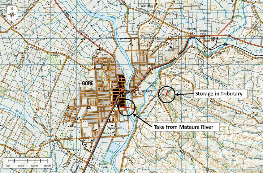
Figure 2.1: Regional Climate Model (RCM)-projected changes in Potential Evapotranspiration Deficit
(PED) (in millimetres accumulation over the July-June ‘water year’) for the 2081-2100 period with respect
to the baseline 1986-2005 period, under RCP4.5 (from Figure 54 of MfE, 2016). Data are mapped on to
NIWA’s 5kmx5km VCSN grid (Tait, 2008)

Figure 2.1 is an example of a drought scenario showing the increase in PED between a present-
day baseline climate (1986-2005) and an end-of-century period (2081-2100) under the
Representative Concentration Pathway (RCP) 4.5. According to this figure, all of New Zealand
would be to some extent drier in the future. So case study areas were initially selected based
on those areas where PED is expected to be greatest (darkest areas in Figure 2.1).

2.1.2 Physical setting and supporting data
To perform a yield analysis in a region, a stream order of greater than 3, an understanding of
the characteristics of the reservoir and its operating rules for diverting flows are needed.
Often, it was found that the initial options identified by the stakeholder group were unsuitable
for analysis because the stream order was too low, and streamflow time series were not
readily available from the TopNet model. Therefore, to meet the requirements of national
spatial coverage and realistic case studies, a more pragmatic approach was adopted, resulting
in the selection of case studies in areas that did not necessarily show a significant increase in
PED under future climate change projections.

2.1.2 Stakeholder Reference Group
A Stakeholder Reference Group (SRG) was constituted to assist in formulating answers to
operational questions that the project team may encounter.
Each member was selected based on their knowledge of the study area’s climate, and of the
water supply schemes. Specifically, SRG members were required to provide inputs to the
project team on the issues below.
• What constitutes a “region”? Is it an administrative region or a climate region?

 8
• How much of a “region” needs to be affected by drought to classify the event as a “regional
 drought” - a precursor to identifying multi-regional droughts?
• How long should a “region” be in drought for there to be significant stress on urban water
 supplies?
• Which Representative Concentration Pathways (RCPs) are considered important?
• How does water allocation work under a drought scenario?
• What is the operating policy for the water supply scheme?
• Directing project team members to the appropriate people to answer water supply related
 questions or to supply water infrastructure related data.
The Stakeholder Reference Group members who guided this project are listed in Appendix B.

2.2 Selected case studies
The selected sites for yield analyses are shown in Figure 2.2 and listed in Table 2.1.

Figure 2.2: Location of sites used in yield analyses

 9

Table 2.1: Selected water supplies for yield analyses

 Region Description
 Northland Storage in Punakitere River
 Auckland Cosseys Dam & Reservoir, Cosseys Creek, Hunua
 Waikato Reservoir in Topehaehae Stream, Matamata Piako District
 Gisborne Gisborne (A run-of-river option from the Te Arai River)
 Taranaki New Plymouth (An option selected from a study carried out for New Plymouth
 District Council (CH2M Beca, 2018)
 Manawatu- Turitea Dams and reservoir, Palmerston North
 Whanganui
 Greater Masterton - A variation on the Black Creek scheme selected including the
 Wellington proposed Wakamoekau and Black Creek Dams and Waingawa run-of-river
 transfer
 Tasman Lee River downstream of Johnstones Road
 Canterbury Lake Pukaki
 Southland Mataura River run-of-river diversion

2.3 Hydrological analysis
2.3.1 Simulated historical and projected future streamflow time series
Daily streamflow time series from 1973 to 2100 were generated by NIWA’s TopNet model,
using simulated daily rainfall from the six Global Climate Models (GCMs), which were
dynamically downscaled. The six GCMs used in this study together with their countries of
origin are as follows:
• BCC-CSM1.1 (China)
• CESM1-CAM5 (USA)
• GISS-E2-R (USA)
• GFDL-CM3 (USA)
• HadGEM2-ES (UK)
• NorESM1-M (Norway)
Simulated historic streamflow time series were generated at selected locations for each of the
six GCMs, from 1973 to 2005 and simulated streamflow time series were generated from 2006
to 2100, for the six GCMs under four representative greenhouse gas concentration Pathways
(RCPs).
The representative concentration pathways are:
• RCP 2.6 (low emissions)
• RCP 4.5 (low-mid emissions)
• RCP 6.0 (mid –high emissions)
• RCP 8.5 (high emissions)

 10
2.3.2 Yield analysis
Quantifying the level of risk that water supply schemes are likely to face under climate change
means that the risk of shortfall in water supply for these schemes has to be determined.
The risk of a shortfall is the inability of the system to supply a base yield for a specified draft or
water take (DWAF, 1986 also refer to Appendix A for yield and draft definitions). In this case
the yield depends on the inflow and storage in the system.
For this project, streamflow inflow time series were generated in TopNet using the rainfall
time series from the six GCMs. These streamflow time series were divided into subsets (see
Table 2.2) to represent inflows for a range of time horizons. The period used for each time
horizon was approximately 35 years for each GCM. Combining the time series for the six GCMs
resulted in 210 years that were simulated for each time horizon. The time horizons, together
with the subset of streamflow used in the yield analyses, are listed in Table 2.2. It is
noteworthy that all subsets of the streamflow series, including the historical series, are
simulated.

Table 2.2: Time horizons used in this study

 Time horizon Subset of streamflow series used
 2005 (historical) 1973 to 2005
 2040 2020 to 2055
 2060 2040 to 2075
 2080 2065 to 2100

A spreadsheet-based model was developed to estimate the draft that could be supplied
without shortfall for 99.5%, 99%, 98% and 95% of the time for the time horizon simulated. Due
to the limited number of streamflow sequences (six) for each time horizon, the assurances of
supply are approximate only. More streamflow sequences would be required to increase
confidence in the yields.
The yield model implements a simple water balance where:
 ( ) = ( −1) + ( ) − (0 ≤ ≤ )

The draft includes all water supplied to users and includes the minimum requirements for the
downstream river usually referred to as compensation flows. This is usually a constant and can
be subtracted from the yield to determine the quantity available for supply.
In the simulations carried out here only the streamflow and releases are considered in the
mass balance. However, in New Zealand the potential evaporation is usually less than rainfall,
resulting in a conservative (slightly underestimated) yield estimate from the approach.
The purpose of the study is to assess the likely effect that climate change will have on water
supply by showing the trend and relative changes in yield with time. Simplifying assumptions,
such as not varying the draft through the year, or not applying variable releases to meet
compensation flow requirements will have little, if any, effect on relative yields.
Simulations were carried out separately using the inflow time series from each of the six GCMs
with the reservoir at full supply capacity at the start of the simulations. Years with simulated
shortfalls in supplying the draft were combined for all six GCMs and divided by the total
number of years in the simulation period to estimate the assurance of supplying the target

 11
draft. Analyses were based on hydrological years, so that periods with shortfall did not cross
calendar year boundaries and remained independent.
Since the only change in the yield analyses at each time horizon is the projected streamflow,
the effect of climate change is implicitly accounted for in this approach.
The Te Arai and Mataura water supply case studies are run of river schemes and don’t have
storage. For these supplies flow duration curves were prepared showing the percentage of
time that flow is exceeded. The flow duration curves were prepared for the same time
horizons and historical record periods used in the yield analyses for those schemes with
storage. The median, and three times median, flow are included on the flow duration curve
plots to add perspective. The median flows were determined from the combined daily flows
for the period 1973 to 2005 for all six GCMs and for all time horizons. Using the exceedance
curves, it now becomes possible to estimate the amount of time that pumping from the river
would be possible under each projected time horizon relative to the historic period.

2.4 Limitations
The following limitations are noted for this study:
• Only ten water supply options/schemes were analysed because of time and budget
 constraints.
• Streamflow time series supplied by NIWA were generated using an uncalibrated TopNet
 model. While this might affect absolute yields, when expressed as a percentage of the
 2005 yield, the relative difference between this and each time horizon and between each
 RCP should be the same. This limitation is discussed in more detail in Section 3.12.
• Simulations were carried out using between 33 and 35 years of daily streamflow from each
 of the six RCMs, (210 years in total) for each time horizon. This limits confidence in the
 yield results.
• In order to provide national coverage, not all water supply schemes analysed were for
 drinking water.
• Static draft and compensation flows were assumed. We know, however, that water
 demand is variable and that many schemes have residual or compensation flow that vary
 depending on the environmental values, minimum flow requirements, etc.
• A simplified analysis where only a single reservoir could be accommodated was used.
• Water supply schemes using groundwater were not considered.

3 Case study yield analyses and results
3.1 Northland
No suitable drinking water supplies were identified for yield analysis in Northland so an
irrigation option with storage of 6 million m3 in the Punakitere River south of Kaikohe was
assessed. This is Option 8 from “Scoping of irrigation scheme options in Northland” prepared
for Northland Regional Council (NRC, 2020). The location of the proposed storage is shown in
Figure 3.1.

 12
Figure 3.1: Location of Northland yield analysis (Option 8 from “Scoping of irrigation scheme options in
Northland”)

Trends in simulated yield as a percentage of the 2005 yield are shown in Figure 3.2.
A decreasing water availability trend is shown for the RCP 8.5 scenario for all levels of
assurance of supply. Under the RCP 6.0 scenario, however, an initial increase in water
availability is observed for all levels of assurance of supply, which is not present for the other
RCP scenarios. Considering the droughts currently being experienced in this region, water
availability is most likely tracking along the RCP paths (RCPs 2.6, 4.5 and 8.5) that show a
decreasing trend in water availability and not the one that shows an increasing trend in water
availability.

 99.5% Assurance: Storage 6 million m³ 99% Assurance: Storage 6 million m³
 RCP 2.6 RCP 4.5 RCP 6.0 RCP 8.5 RCP 2.6 RCP 4.5 RCP 6.0 RCP 8.5
 115% 115%

 110% 110%
 Percentage of 2005 yield

 Percentage of 2005 yield

 105% 105%

 100% 100%

 95% 95%

 90% 90%

 85% 85%

 80% 80%
 2000 2010 2020 2030 2040 2050 2060 2070 2080 2000 2010 2020 2030 2040 2050 2060 2070 2080
 Year Year

 13
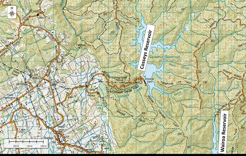
98% Assurance: Storage 6 million m³ 95% Assurance: Storage 6 million m³
 RCP 2.6 RCP 4.5 RCP 6.0 RCP 8.5 RCP 2.6 RCP 4.5 RCP 6.0 RCP 8.5
 115% 115%

 110% 110%
Percentage of 2005 yield

 Percentage of 2005 yield
 105% 105%

 100% 100%

 95% 95%

 90% 90%

 85% 85%

 80% 80%
 2000 2010 2020 2030 2040 2050 2060 2070 2080 2000 2010 2020 2030 2040 2050 2060 2070 2080
 Year Year

Figure 3.2: Yield results: Northland (Storage 6 million m3) expressed as percentage of 2005 yield

3.2 Auckland
Cosseys Reservoir in the Cosseys Creek is part of Watercare’s water supply infrastructure for
supplying water in the Auckland area. The location of the reservoir is shown in Figure 3.3. This
dam was selected because the inflow reach NZREACH 2042441 is Strahler 4 and inflows were
available from NIWA. The reservoir has a working storage of approximately 14 million m3,
which is approximately 50% of the mean annual runoff from the catchment. Yields were
determined for a July to June hydrological year.

Figure 3.3: Location of Auckland yield analysis

Yields from the reservoir were calculated for assurances of 99.5%, 99%, 98% and 95% and time
horizons of 2005 (historic), 2040, 2060 and 2080 to assess trends due to climate change.
Figure 3.4 shows plots of the trends in yield with time as a percentage of the 2005 yield.

 14
At the highest assurance level of supply there is an initial decrease for all RCPs except RCP 8.5.
For RCP 8.5, however, there is an increase in water yield for the 2040 time horizon before
showing a decreasing trend thereafter. At the highest level of assurance of supply, the other
RCP scenarios show an upward trend after the 2040 time horizon.

 99.5% Assurance: Storage 14 million m³ 99% Assurance: Storage 14 million m³
 RCP 2.6 RCP 4.5 RCP 6.0 RCP 8.5 RCP 2.6 RCP 4.5 RCP 6.0 RCP 8.5
 110% 110%
 108%
 106%
 Percentage of 2005 yield

 Percentage of 2005 yield
 105%
 104%
 102%
 100% 100%
 98%
 96%
 95%
 94%
 92%
 90% 90%
 2000 2010 2020 2030 2040 2050 2060 2070 2080 2000 2010 2020 2030 2040 2050 2060 2070 2080
 Year Year

 98% Assurance: Storage 14 million m³ 95% Assurance: Storage 14 million m³
 RCP 2.6 RCP 4.5 RCP 6.0 RCP 8.5 RCP 2.6 RCP 4.5 RCP 6.0 RCP 8.5
 108% 110%

 106% 108%

 104% 106%
 Percentage of 2005 yield

 Percentage of 2005 yield

 104%
 102%
 102%
 100%
 100%
 98%
 98%
 96%
 96%
 94% 94%
 92% 92%
 90% 90%
 2000 2010 2020 2030 2040 2050 2060 2070 2080 2000 2010 2020 2030 2040 2050 2060 2070 2080
 Year Year

Figure 3.4: Yield results: Auckland – Cosseys Reservoir (Storage 14 million m3) expressed as percentage of
2005 yield

3.3 Waikato
The Waikato Regional Council identified an existing water supply scheme that utilises storage
of approximately 0.32 million m3 in the Topehaehae Stream, east of Hamilton. The location of
the scheme is shown in Figure 3.5 (nzsegment 3063858).
Current consents permit a maximum of 12,000 m3/day to be taken from storage and specify a
minimum downstream release of 0.03 m3/s, except for up to 100 days per year when the
minimum downstream release can be reduced to 0.007 m3/s. Yield analyses for this study
assume that downstream releases are constant and included in the yield that is taken as a
constant draft. Yields were determined for a January to December hydrological year.

 15
Figure 3.5: Location of Waikato yield analysis

Figure 3.6 shows plots of trends in yield with time, as a percentage of the 2005 yield. The
results show that, except for RCP 8.5 the water yield remains fairly constant (±5% of the 2005
yield) into the future. For RCP 8.5 the water yield shows a significant decrease from the 2040
time horizon onwards with the decrease being more pronounced for the higher assurance
level of supply.

 99.5% Assurance: Storage 0.3 million m³ 99% Assurance: Storage 0.3 million m³
 RCP 2.6 RCP 4.5 RCP 6.0 RCP 8.5 RCP 2.6 RCP 4.5 RCP 6.0 RCP 8.5
 120% 120%

 115% 115%
 Percentage of 2005 yield

 Percentage of 2005 yield

 110% 110%

 105% 105%

 100% 100%

 95% 95%

 90% 90%

 85% 85%

 80% 80%
 2000 2010 2020 2030 2040 2050 2060 2070 2080 2000 2010 2020 2030 2040 2050 2060 2070 2080
 Year Year

 98% Assurance: Storage 0.3 million m³ 95% Assurance: Storage 0.3 million m³
 RCP 2.6 RCP 4.5 RCP 6.0 RCP 8.5 RCP 2.6 RCP 4.5 RCP 6.0 RCP 8.5
 120% 120%

 115% 115%
Percentage of 2005 yield

 Percentage of 2005 yield

 110% 110%

 105% 105%

 100% 100%

 95% 95%

 90% 90%

 85% 85%

 80% 80%
 2000 2010 2020 2030 2040 2050 2060 2070 2080 2000 2010 2020 2030 2040 2050 2060 2070 2080
 Year Year

Figure 3.6: Yield results: Topehaehae (Storage 0.32 million m3) expressed as percentage of 2005 yield

 16
3.4 Gisborne
The main water supply to Gisborne is from the Mangapoike Dams. A potential source to
augment water supply to Gisborne is from a run-of-river source in the Te Arai River at the
location shown in Figure 3.7. This case study was specifically selected to show how the
projected streamflow information can be applied to run-of-river schemes.
Abstractions from the Te Arai River will depend on discharge in the river at the time, and on
downstream water requirements, will have to be agreed. These rules will likely stipulate
minimum discharge (e.g. maintaining a median historical discharge) in the river before
abstractions can commence as well as maximum allowable abstraction (e.g. 3 x median
historical discharge). The scheme will not be able to deliver a constant draft because the
discharge in the river will be variable.
The Te Arai option would supply water when available so that water stored in the dams can be
used during low flow periods. Accordingly, analyses for this option were limited to preparing
flow duration curves that can be used to assess the percentage of time and how much water
can be abstracted from a run-of-river type scheme. Flow duration curves were generated for
the pseudo stationary periods 35 years long associated with each of the time horizons 2040,
2060 and 2080. These curves, together with the median and three times median flow from the
historic streamflow time series, (1973 to 2005) are shown in Figure 3.8, the projected change
in flow with time for selected percentage exceedances in Figure 3.9, and as a percentage of the
2005 flows in Figure 3.10.
Figure 3.10 shows a general trend in reduced flows in the Te Arai River. By 2080 median flows
(50% exceedance) are projected to decrease by approximately 3% for RCP 2.6, 7% for RCP 4.5
and RCP 6.0 and 14% for RCP 8.5.

Figure 3.7: Location of Gisborne yield analysis

 17
Flow duration curves: 2040 Flow duration curves: 2060
 Median 3 x Median RCP 2.6 RCP 4.5 RCP 6.0 RCP 8.5 Median 3 x Median RCP 2.6 RCP 4.5 RCP 6.0 RCP 8.5

 200 200
 180 180
 Streamflow (thousand m³/day)

 Streamflow (thousand m³/day)
 160 160
 140 140
 120 120
 100 100
 80 80
 60 60
 40 40
 20 20
 0 0
 0% 10% 20% 30% 40% 50% 60% 0% 10% 20% 30% 40% 50% 60%
 Percentage of time exceeded Percentage of time exceeded

 Flow duration curves: 2080
 Median 3 x Median RCP 2.6 RCP 4.5 RCP 6.0 RCP 8.5

 200
 180
 Streamflow (thousand m³/day)

 160
 140
 120
 100
 80
 60
 40
 20
 0
 0% 10% 20% 30% 40% 50% 60%
 Percentage of time exceeded

Figure 3.8: Flow duration curves for Te Arai River at proposed take for time horizons 2040, 2060 and
2080

 RCP 2.6 RCP 4.5
 10% 15% 20% 30% 40% 50% 10% 15% 20% 30% 40% 50%

 200 200
 180 180
 Streamflow (thousand m³/day)

 Streamflow (thousand m³/day)

 160 160
 140 140
 120 120
 100 100
 80 80
 60 60
 40 40
 20 20
 0 0
 2000 2020 2040 2060 2080 2000 2020 2040 2060 2080
 Time horizon Time horizon

 RCP 6.0 RCP 8.5
 10% 15% 20% 30% 40% 50% 10% 15% 20% 30% 40% 50%

 180 180

 160 160
 Streamflow (thousand m³/day)

 Streamflow (thousand m³/day)

 140 140

 120 120

 100 100

 80 80

 60 60

 40 40

 20 20

 0 0
 2000 2020 2040 2060 2080 2000 2020 2040 2060 2080
 Time horizon Time horizon

Figure 3.9: Simulated flows in Te Arai River for a range of exceedances for RCP 2.6, RCP 4.5, RCP 6.0 and
RCP 8.5 and time horizons from 2005 to 2080

 18
RCP 2.6 RCP 4.5
 10% 15% 20% 30% 40% 50% 10% 15% 20% 30% 40% 50%

 105% 105%

 100% 100%
 Percentage of 2005 flow

 Percentage of 2005 flow
 95% 95%

 90% 90%

 85% 85%

 80% 80%
 2000 2020 2040 2060 2080 2000 2020 2040 2060 2080
 Time horizon Time horizon

 RCP 6.0 RCP 8.5
 10% 15% 20% 30% 40% 50% 10% 15% 20% 30% 40% 50%

 105% 105%

 100% 100%
 Percentage of 2005 flow

 Percentage of 2005 flow
 95% 95%

 90% 90%

 85% 85%

 80% 80%
 2000 2020 2040 2060 2080 2000 2020 2040 2060 2080
 Time horizon Time horizon

Figure 3.10: Simulated flows in Te Arai River for a range of exceedances for RCP 2.6, RCP 4.5, RCP 6.0 and
RCP 8.5 and time horizons from 2005 to 2080 expressed as percentage of 2005 flows

 19
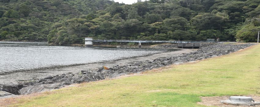
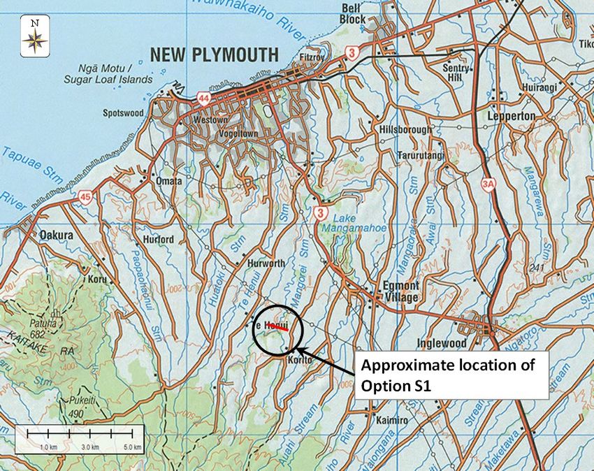
3.5 Taranaki
New Plymouth District Council has identified potential options to augment its water supply.
Option S1, shown in Figure 3.11, was selected for yield analysis. It is an online water storage
dam near the confluence of the Korito and Mangorei Streams. Maximum storage is
approximately 6.5 million m3, which is about 3.5% of the mean annual runoff (MAR) from the
catchment. No other storage sizes were analysed for this option.
Daily streamflow time series for the period 1973 to 2100 were obtained from NIWA for
NZREACH 6172523 for input to the yield model.

Figure 3.11: Location of Taranaki yield analysis

Figure 3.12 shows plots of the future trend in yield as a percentage of the 2005 yield. Except
for the RCP 6.0 scenario, the other RCP scenarios show a decreasing trend in water availability
at the 99.5% and 99% assurance of supply. The RCP 6.0 scenario shows an initial increase at
water availability at the 2040 time horizon before decreasing. For the lower levels of assurance
supply the RCP 8.5 scenario shows the most marked downward trend in water availability.

 20
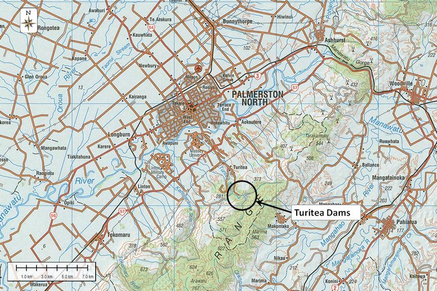
99.5% Assurance: Storage 6.5 million m³ 99% Assurance: Storage 6.5 million m³
 RCP 2.6 RCP 4.5 RCP 6.0 RCP 8.5 RCP 2.6 RCP 4.5 RCP 6.0 RCP 8.5
 110% 110%
 105% 105%
 100% 100%
Percentage of 2005 yield

 Percentage of 2005 yield
 95% 95%
 90% 90%
 85% 85%
 80% 80%
 75% 75%
 70% 70%
 65% 65%
 60% 60%
 2000 2010 2020 2030 2040 2050 2060 2070 2080 2000 2010 2020 2030 2040 2050 2060 2070 2080
 Year Year

 98% Assurance: Storage 6.5 million m³ 95% Assurance: Storage 6.5 million m³
 RCP 2.6 RCP 4.5 RCP 6.0 RCP 8.5 RCP 2.6 RCP 4.5 RCP 6.0 RCP 8.5
 110% 110%
 105% 105%
 100% 100%
Percentage of 2005 yield

 Percentage of 2005 yield
 95% 95%
 90% 90%
 85% 85%
 80% 80%
 75% 75%
 70% 70%
 65% 65%
 60% 60%
 2000 2010 2020 2030 2040 2050 2060 2070 2080 2000 2010 2020 2030 2040 2050 2060 2070 2080
 Year Year

Figure 3.12: Yield results: New Plymouth Option S1 (Storage 6.5 million m3) expressed as percentage of
2005 yield

3.6 Manawatu – Whanganui
Surface water is supplied to Palmerston North from the Turitea Dams located to the south of
the city (Figure 3.13). For the purposes of assessing how yield could change due to climate
change, storage in the two reservoirs was combined to give a total storage of 1.8 million m3.
Inflow time series for total inflow to the two dams (NZREACH 7240764 - Strahler 3) were used.

Figure 3.12: Location of Manawatu - Whanganui yield analysis

 21
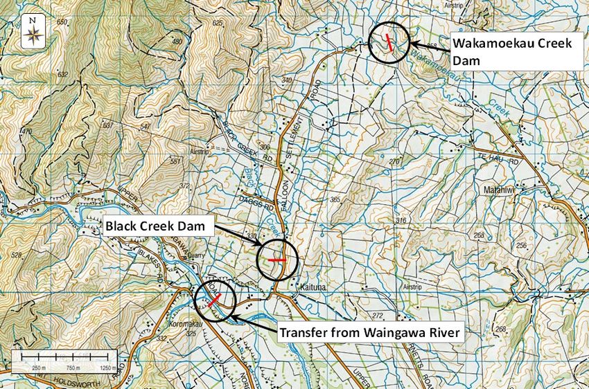
Figure 3.14 shows plots of the future trend in yield as a percentage of the 2005 yield. The plots
indicate a general decreasing trend in yield at the highest level of assurance of supply from the
2060 time horizon. With a lower assurance level of supply the water yield remains stable
across the future time horizons.

 99.5% Assurance: Storage 1.8 million m³ 99% Assurance: Storage 1.8 million m³
 RCP 2.6 RCP 4.5 RCP 6.0 RCP 8.5 RCP 2.6 RCP 4.5 RCP 6.0 RCP 8.5
 120% 120%

 115% 115%
 Percentage of 2005 yield

 Percentage of 2005 yield
 110% 110%

 105% 105%

 100% 100%

 95% 95%

 90% 90%

 85% 85%

 80% 80%
 2000 2010 2020 2030 2040 2050 2060 2070 2080 2000 2010 2020 2030 2040 2050 2060 2070 2080
 Year Year

 98% Assurance: Storage 1.8 million m³ 95% Assurance: Storage 1.8 million m³
 RCP 2.6 RCP 4.5 RCP 6.0 RCP 8.5 RCP 2.6 RCP 4.5 RCP 6.0 RCP 8.5
 120% 120%

 115% 115%
 Percentage of 2005 yield

 Percentage of 2005 yield

 110% 110%

 105% 105%

 100% 100%

 95% 95%

 90% 90%

 85% 85%

 80% 80%
 2000 2010 2020 2030 2040 2050 2060 2070 2080 2000 2010 2020 2030 2040 2050 2060 2070 2080
 Year Year

Figure 3.13: Yield results: Palmerston North Turitea Dams (Storage 1.8 million m3) expressed as
percentage of 2005 yield

3.7 Greater Wellington Regional Council
The proposed Black Creek Scheme in the Masterton area was identified as a potential option
for supplying water to Masterton. The proposed scheme comprises dams in the Black Creek
and Wakamoekau Creek with transfer into the reservoir from the Waingawa River downstream
of the Atiwhakatu Stream confluence. The approximate location of the dams and transfer
from the Waingawa River are shown in Figure 3.15. The Black Creek and Wakamoekau Creek
reservoirs are connected by an open channel and operate as a single reservoir with live storage
of 46.2 million m3.
Daily streamflow time series for the period 1973 to 2100 were obtained for NZREACH 9254606
(Black Creek), NZREACH 9253545 (Wakamoekau Creek), and NZREACH 9254601 (Waingawa
River) for input to the yield model. The flows for NZREACH 9254271 were requested for Black
Creek inflows but the more readily available NZREACH 9254606 was accepted because the
incremental runoff is minimal.
Water is pumped from the Waingawa River into Black Creek Reservoir. The transfer of water
from the Waingawa River is based on the following: when flow in the river is between the
median (7.4 m3/s) and three times the median flow (22.3 m3/s), then half the flow in the

 22
Waingawa River is transferred to the reservoir. The maximum transfer to storage was set at
5.6 m3/s.
The daily flows into Black Creek and Wakamoekau Creek reservoirs were combined with
transfers from the Waingawa River to generate the inflow time series for the combined
storage used in the yield analysis.
The yield model was used to determine yields for of 99.5%, 99%, 98% and 95% assurances for
2005, 2040, 2060 and 2080 time horizons with live storage of 46.2 million m3.

Figure 3.14: Location of the Greater Wellington Regional Council yield analysis

Figure 3.16 shows plots of trends in yield with time, as a percentage of the 2005 yield. The
plots indicate that yields could decrease by 2080 for all be the RCP 2.6 scenario. The largest
decrease in yield being observed under the RCP 8.5 scenario. Yields under the other RCPs also
show a decreasing trend but is not as marked as the decreasing trend of the RCP 8.5 scenario.

 99.5% Assurance Storage 46 million m³ 99% Assurance Storage 46 million m³
 RCP 2.6 RCP 4.5 RCP 6.0 RCP 8.5 RCP 2.6 RCP 4.5 RCP 6.0 RCP 8.5
 102% 102%

 100% 100%
 Percentage of 2005 yield
 Percentage 0f 2005 yield

 98% 98%

 96% 96%

 94% 94%

 92% 92%

 90% 90%
 2000 2010 2020 2030 2040 2050 2060 2070 2080 2000 2010 2020 2030 2040 2050 2060 2070 2080
 Year Year

 23
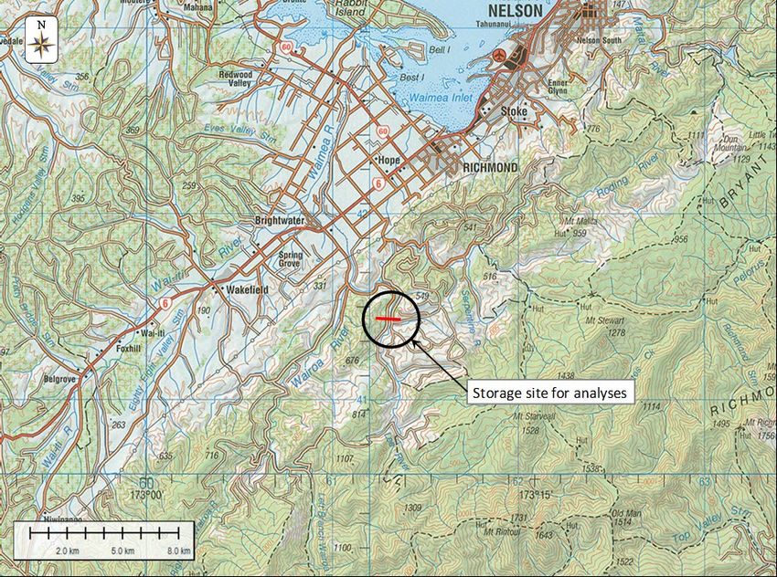
98% Assurance Storage 46 million m³ 95% Assurance Storage 46 million m³
 RCP 2.6 RCP 4.5 RCP 6.0 RCP 8.5 RCP 2.6 RCP 4.5 RCP 6.0 RCP 8.5
 102% 102%

 100% 100%
Percentage of 2005 yield

 Percentage of 2005 yield
 98% 98%

 96% 96%

 94% 94%

 92% 92%

 90% 90%
 2000 2010 2020 2030 2040 2050 2060 2070 2080 2000 2010 2020 2030 2040 2050 2060 2070 2080
 Year Year

Figure 3.15: Yield results: Masterton Black Creek option (Storage 46.2 million m3) expressed as a
percentage of 2005 yield

3.8 Tasman
Streamflow data was provided for the reach downstream of Johnstones Road and this
streamflow was used to analyse the water availability at the storage site as shown in Figure
3.17. Daily streamflow was obtained from NIWA for NZREACH 10021002 (Strahler 4) and
working storage in the reservoir was nominally set at 25% of the mean annual runoff from the
catchment.

Figure 3.16: Location of Tasman yield analysis

 24
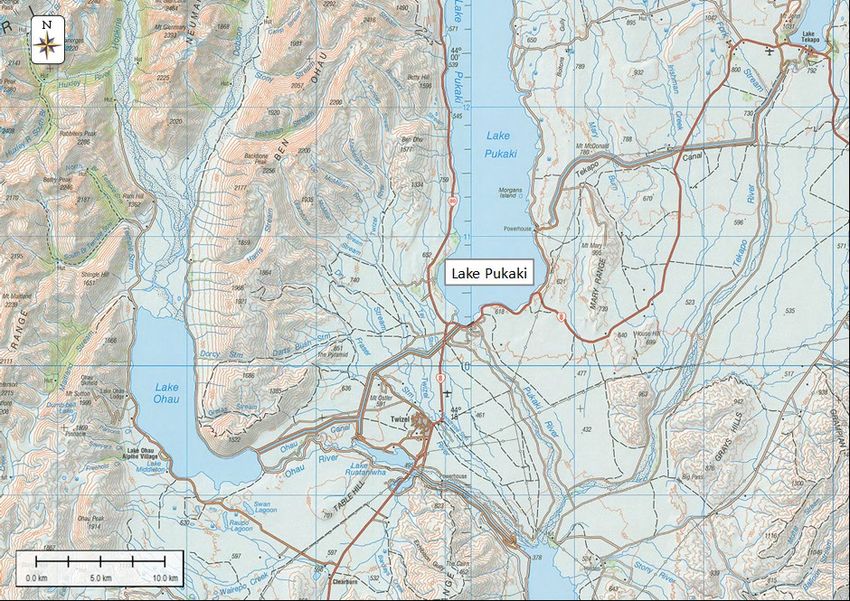
Figure 3.18 shows plots of trends in yield with time, as a percentage of the 2005 yield. The
results indicate an initial projected upward trend in water availability at high assurance yields
(99.5% and 99% assurance) under the RCP 8.5 scenario and a decreasing trend thereafter. For
the other RCPs no initial increasing trend is observed with yield showing a general decreasing
trend towards the 2080 time horizon.

 99.5% Assurance: Storage 23 million m³ 99% Assurance: Storage 23 million m³
 RCP 2.6 RCP 4.5 RCP 6.0 RCP 8.5 RCP 2.6 RCP 4.5 RCP 6.0 RCP 8.5
 110% 110%

 105% 105%
 Percentage of 2005 yield

 Percentage of 2005 yield
 100% 100%

 95% 95%

 90% 90%

 85% 85%

 80% 80%

 75% 75%
 2000 2010 2020 2030 2040 2050 2060 2070 2080 2000 2010 2020 2030 2040 2050 2060 2070 2080
 Year Year

 98% Assurance: Storage 23 million m³ 95% Assurance: Storage 23 million m³
 RCP 2.6 RCP 4.5 RCP 6.0 RCP 8.5 RCP 2.6 RCP 4.5 RCP 6.0 RCP 8.5
 110% 110%

 105% 105%
 Percentage of 2005 yield

 Percentage of 2005 yield

 100% 100%

 95% 95%

 90% 90%

 85% 85%

 80% 80%

 75% 75%
 2000 2010 2020 2030 2040 2050 2060 2070 2080 2000 2010 2020 2030 2040 2050 2060 2070 2080
 Year Year

Figure 3.17: Yield results: Tasman (Storage 6 million m3) expressed as percentage of 2005 yield

3.9 Canterbury
Most of the drinking water supply in Canterbury is obtained from groundwater sources and
not amenable to analysis using the methodology in the study. In order to provide national
coverage, Lake Pukaki was therefore selected as a case study and as a surrogate for other
water supplies in the region. Operating storage in Lake Pukaki was obtained from Meridian
Energy and daily inflow time series to the lake for NZREACH 13165194 (Strahler 6) were
obtained from NIWA. The operating storage used in the yield analyses is 2,395 million m3.
The location of the lake is shown in Figure 3.19. Figure 3.20 shows plots of trends in yield with
time, as a percentage of the 2005 yield.
Because high inflows to the lake - due to snow melt - occur late in late winter and spring,
calendar years were used in the yield assessment rather than a July to June hydro-year so that
shortfall years are independent.

 25
Figure 3.18: Canterbury: Lake Pukaki

Figure 3.20 shows plots of trends in yield with time, as a percentage of the 2005 yield. The
simulation results show a general increase in yield by 2080 with the RCP 8.5 scenario displaying
the largest increase in yield.
 99.5% Assurance: Storage 2395 million m³ 99% Assurance: Storage 2395 million m³
 RCP 2.6 RCP 4.5 RCP 6.0 RCP 8.5 RCP 2.6 RCP 4.5 RCP 6.0 RCP 8.5
 120% 120%

 115% 115%
 Percentage of 2005 yield

 Percentage of 2005 yield

 110% 110%

 105% 105%

 100% 100%

 95% 95%

 90% 90%

 85% 85%

 80% 80%
 2000 2010 2020 2030 2040 2050 2060 2070 2080 2000 2010 2020 2030 2040 2050 2060 2070 2080
 Year Year

 98% Assurance: Storage 2395 million m³ 95% Assurance: Storage 2395 million m³
 RCP 2.6 RCP 4.5 RCP 6.0 RCP 8.5 RCP 2.6 RCP 4.5 RCP 6.0 RCP 8.5
 120% 120%

 115% 115%
 Percentage of 2005 yield

 110%
Percentage of 2005 yield

 110%

 105% 105%

 100% 100%

 95% 95%

 90% 90%

 85%
 85%
 80%
 80%
 2000 2010 2020 2030 2040 2050 2060 2070 2080
 2000 2010 2020 2030 2040 2050 2060 2070 2080
 Year
 Year

Figure 3.19: Yield results: Canterbury Lake Pukaki (Storage 2,395 million m3) expressed as percentage of
2005 yield

 26
3.10 Southland
The Mataura River flows through Gore. An option to augment water supply to the town is
shown in Figure 3.21. It comprises storage on a tributary to the east of the town with transfers
from the Mataura River to fill the reservoir. Daily stream flows were obtained from NIWA for
the Mataura River (NZREACH 15300394 - Strahler 7) and the tributary (NZREACH 15300360 -
Strahler 3). Yield analyses were carried out for an option with storage in the tributary and
transfers of half the flow in the Mataura River when flow is between the median, and three
times the median flow, to assess possible trend in yield due to climate change.

Figure 3.20: Location of Southland yield analysis

Figure 3.22 shows plots of trends in yield with time, as a percentage of the 2005 yield. Trends
at the higher level of assurance of supply (99.5% and 99%) are not easily discernible and
remains relatively stable. At the lowest level of assurance of supply an increasing yield is
noted for RCPs 6.0 and 8.5.

 99.5% Assurance: Storage 0.32 million m³ 99% Assurance: Storage 0.32 million m³
 RCP 2.6 RCP 4.5 RCP 6.0 RCP 8.5 RCP 2.6 RCP 4.5 RCP 6.0 RCP 8.5
 110% 110%
 Percentage of 2005 yield
 Percentage of 2005 yield

 105% 105%

 100% 100%

 95% 95%

 90% 90%
 2000 2010 2020 2030 2040 2050 2060 2070 2080 2000 2010 2020 2030 2040 2050 2060 2070 2080
 Year Year

 27
98% Assurance: Storage 0.32 million m³ 95% Assurance: Storage 0.32 million m³
 RCP 2.6 RCP 4.5 RCP 6.0 RCP 8.5 RCP 2.6 RCP 4.5 RCP 6.0 RCP 8.5
 110% 110%
Percentage of 2005 yield

 Percentage of 2005 yield
 105% 105%

 100% 100%

 95% 95%

 90% 90%
 2000 2010 2020 2030 2040 2050 2060 2070 2080 2000 2010 2020 2030 2040 2050 2060 2070 2080
 Year Year

Figure 3.21: Yield results: Southland (Storage 0.32 million m3) expressed as percentage of 2005 yield

3.11 Discussion
Northland, Taranaki, Manawatu-Whanganui, Greater Wellington Regional Council and Tasman
storage-based case studies all show a decrease in yield under climate change. This possibly
indicates that there will be longer low flow periods in the streamflow sequences as a result in
climate change for these case study areas. These case studies are not located in the areas
showing the largest increase in PED, but do seem to occur in areas of notable increases in PED
shown Figure 2.1.
For the Auckland and Waikato case studies an overall trend is not that clear, but for RCP 8.5
there is a clear decreasing yield from 2040 onwards.
The Gisborne case study considers a run-of-river scheme and shows a general decrease in the
projected flows.
The Canterbury case study showed an increase in yield into the future with this increase being
largest under RCP 8.5. The Southland case studies showed a decrease in yield for all but the
RCPs 2.6 scenario at the 2040 horizon at the higher levels of assurance of supply (99.5% and
99%). This, however, can be incidental if the water availability far exceeds the demands on the
system.
It is worth noting that where long term decreased yields have been predicted, they may still be
adequate when compared with future demands on the system, as we have assumed that
demand remains constant. The fact that some of these schemes are proposed suggests that
there is increasing demand experienced in these regions, and it would be expected that
population growth and increased economic activity would result in increased water demand.
Although we acknowledged that increased storage in a water supply system will increase its
resilience to drought, storage cannot be increased without bounds. Other factors, such as the
need to meet the outcomes of the National Policy Statement on Freshwater Management and
Te Mana O Te Wai, cost and loss of value from land inundated by storage schemes, also need
to be taken into account.

 28
3.12 Limitations of analyses
The analyses in this project were undertaken within the context of long-term yield analysis
under climate change conditions. This implies that the performance of the reservoir was
assessed based on a full supply starting level, subjected to various target draft levels and fed
by a reasonably long inflow sequence. It is also important that the demand pattern and
operating policies do not vary from one sequence to another. Whether one is determining
historical or future reservoir yields, these will still be determined by the severest critical sub-
sequence in the sequence of inflows.
Using streamflow from an uncalibrated hydrological model (as was done in this study) means
that absolute values of flows and yields are not representative of reality. Relative differences
will however be useful, since errors will be conserved between simulations at the different
time horizons.
Overall, the stochastic determination of reservoir yield and many other hydrological
computational procedures also rely on the assumption that the streamflow (historical or
projected future) annual totals and extremes vary about a constant mean value, with constant
variance and constant serial correlation (stationarity/constancy) (Clarke, 2007). By virtue of the
short streamflow record used in this study, these criteria have been adhered to.
Previous applications of historical reservoir yield determination have used a 64-year record
length (Basson et al., 1994) where the probability of observing a drought with a 100-year
average recurrence interval (ARI) is 47%, while the probability of observing a 200-year (ARI)
drought would be 27%. The probability of encountering a 100-year ARI (or worse) drought in a
36-year streamflow record length is therefore significantly reduced in this study.
When determining yields, stochastically generated flow sequences provide alternative pasts or
futures that are required to assess the probabilistic behaviour of reservoir/river yields. Earlier
applications of this methodology showed that more than 40 stochastically generated flow
sequences are typically required for quantifying reliability of supply. In this study, however,
stochastic stream flow sequences were produced based on inputs from the six Regional
Climate Models (RCMs).
In this project the question of what future flow records are likely to look like at a particular
future horizon has been answered by using the outputs from the climate models, which were
then propagated through the TopNet hydrological model to produce an inflow sequence. This
approach determines whether the considered future time horizons are generally wetter or
drier and provides a simplified method for using existing climate change data in water
availability studies.
In spite of limitations alluded to in the previous paragraphs, this study clearly highlights the
effort required to mobilise existing climate change data to obtain projected streamflow under
various RCP scenarios, and confirms that a sufficient amount of climate change data already
exists to allow for the quantification of available water yield in the various climatic regions of
New Zealand.
However, it is clear that the approach in this study has two clear limitations:
• The length of the projected inflow sequence is short, and this has the potential to miss the
 critical low flow periods that determine water availability, leading to an optimistic estimate
 of water availability.
• The number of stochastic sequences for each time horizon is small and this has the
 potential to also lead to optimistic estimates of water availability.

 29
Despite these limitations, the yield analyses results in this study provide a sufficiently robust
method to assess the relative effects of climate change on water supply. However, this
approach would need refinement before application within a detailed planning context is
attempted.

4 Supporting Te Mana O Te Wai
The analyses presented in this report all consider the effects of climate change with the
purpose of understanding whether existing or proposed water supply uses will be able to be
met. These water uses are managed via resource consents usually through a water allocation
regime set out in a Regional Plan and by requirements to mitigate adverse effects of these uses
on water quality and ecology, predominantly during periods of drought or low flow. This has
been accounted for in our analysis through the provision of compensation or residual flows,
where this information was available.
A selection of Iwi Management Plans were reviewed in order to identify to how these plans
consider matters such as water allocation, drought and climate change, and to highlight the
potential links between the matters raised in these plans and this research. Key themes
emerging from this high-level review were the recognition of the importance of water supply
and its resilience to climate change and drought, water availability to papakāinga and marae
and sustainability of water flow.
While on face value the sustainability of water flow could appear to be met through the
provision of compensation flows, the matters raised in Iwi Management Plans point to the
need to more deeply and holistically consider how water is managed.
For many centuries, Iwi have maintained a strong intrinsic relationship with their Awa
Tuupuna. Within this relationship exists mana whakahaere – roles and responsibilities to the
Awa Tuupuna as well as Mana Whanake - to ensure the health and wellbeing of the Awa. Iwi
view rivers and streams holistically so it includes not just the water but also the bed, banks,
flood plains, flora and fauna and its metaphysical wellbeing. Iwi view their role as responsible
for the river’s long-term sustainability and viewed in its entirety. Therefore, the continuous
supply of fresh water is seen as fundamental to the sustainable social, environmental, cultural
and economic development for Iwi and Mana o Te Wai.
The concept of Te Mana O Te Wai, which is a part of the Government’s recently proposed
National Policy Statement on Freshwater Management, promotes a framework in which water
use and its allocation is considered. In its broadest sense, Te Mana O Te Wai recognises the
fundamental value of water and the importance of prioritising the health and wellbeing of the
water before providing for human needs and wants.
In the context of climate change, giving effect to Te Mana O Te Wai would require rethinking
and resetting of current resource management priorities. First and foremost, it would demand
that the needs of the waterbody are provided for, based on both Mātauranga Māori and
science. From a science perspective, this would require a much deeper understanding of the
effects of climate change on surface water regimes, and its subsequent effects on ecology,
water quality and in-stream processes.

 30
You can also read


