The Worcestershire Biodiversity
                   Action Plan
←
→
Page content transcription
If your browser does not render page correctly, please read the page content below
The Worcestershire Biodiversity
Action Plan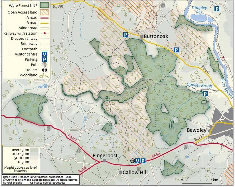
Abstract
Following its commitment to the 1992 Convention on Biological Diversity the UK began to develop a
policy and strategy framework, beginning with Biodiversity Action Plans and recently with a focus on
ecological networks and green infrastructure. This project contributed to Worcestershire’s Biodiversity
Action Plan review process by demonstrating how green infrastructure (GI) can be identified and
delivered in the Urban Habitat Action Plan. GI provides multifunctional benefits, so will help encourage
biodiversity through a wide network of green spaces and corridors in urban and natural environments. It
is crucial that biodiversity is conserved and sustainably managed for future generations because it
provides direct and indirect services for people, such as food and climate regulation.

                                                                                                       i
                             Worcestershire Biodiversity Action Plan 2018
                                          H14 Urban HAP
Table of Contents
Abstract ................................................................................................................................................... i
Table of Contents .................................................................................................................................... ii
Table of Figures ...................................................................................................................................... iii
Abbreviations ......................................................................................................................................... iv
1      Introduction .................................................................................................................................... 1
2      Current Status ................................................................................................................................. 3
    2.1       Description of habitat............................................................................................................... 3
    2.2       Green Infrastructure typology .................................................................................................. 3
    2.3       Description of Key Species ........................................................................................................ 7
       2.3.1          Slow-worm Anguis fragilis ................................................................................................ 8
       2.3.2          European Hedgehog Erinaceus europaeus ........................................................................ 9
       2.3.3          House Sparrow Passer domesticus .................................................................................. 10
       2.3.4          Great Crested Newt Triturus cristatus ............................................................................. 11
       2.3.5          Water vole Arvicola terrestris ......................................................................................... 12
       2.3.6          Pipistrelle bat Pipistrellus spp. ........................................................................................ 13
    2.4       Legislation and Policy Drivers ................................................................................................. 14
    2.5       Summary of Important Sites ................................................................................................... 14
3      Current Pressures .......................................................................................................................... 17
    3.1       Factors Affecting Habitats and Species ................................................................................... 17
    3.2       Slow-worm Case Study ........................................................................................................... 17
4      Current Action ............................................................................................................................... 18
    4.1       Delivering and Protecting GI through Policy and Legislation ................................................... 18
       4.1.1          Worcestershire Local Sites (LS’s) ..................................................................................... 18
       4.1.2          Local Plan Documents (LPDs) .......................................................................................... 19
    4.2       Ongoing Management of GI Habitat Assets ............................................................................ 21
    4.3       Taking Action for Priority Species in the Urban Environment .................................................. 22
       4.3.1          Sanders Park, Bromsgrove Case Study ............................................................................ 22
       4.3.2          Lansdowne Crescent Allotments ..................................................................................... 23
    4.4       Survey, Research, and Monitoring of GI Assets and Urban Wildlife ......................................... 23
5      References..................................................................................................................................... 24

                                                                                                                                                            ii
                                             Worcestershire Biodiversity Action Plan 2018
                                                          H14 Urban HAP
Table of Figures
Figure 1 Map of Worcestershire County. Data from the WBRC (2018) ..................................................... 2
Figure 2 Identification of main GI typologies as a combination of different vegetation layers, ground
surfaces and building structures (Koc, Osmond, & Peters, 2016) .............................................................. 4
Figure 3 Worcester City has 26 allotments that vary in location and number of plots available to rent.
Data from WBRC (2018) .......................................................................................................................... 6
Figure 4 Slow-worm colonies in Worcestershire. Data from WBRC (2018)................................................ 8
Figure 5 Hedgehog colonies in Worcestershire. Data from WBRC (2018). ................................................ 9
Figure 6 House sparrow colonies in Worcestershire. Data from WBRC (2018). ....................................... 10
Figure 7 Great crested newt colonies in Worcestershire. Data from WBRC (2018). ................................ 11
Figure 8 Water vole colonies in Worcestershire. Data from WBRC (2018). ............................................. 12
Figure 9 Pipistrellus spp. colonies in Worcestershire. Data from WBRC (2018). ...................................... 13
Figure 10 Lansdowne allotments in Worcester City................................................................................ 14
Figure 11 Map of Wyre Forest (Natural England, Wyre Forest: National Nature Reserve, 2010) ............. 16
Figure 12 Delivering GI at different scales (modified from (Worcestershire County Council, 2015)) ....... 22

                                                                                                                                               iii
                                         Worcestershire Biodiversity Action Plan 2018
                                                      H14 Urban HAP
Abbreviations

AW      Ancient Woodland
BAP     Biodiversity Action Plan
CBD     Convention on Biological Diversity
Defra   Department of Environment, Food, and Rural Affairs
EU      European Union
GI      Green Infrastructure
HAP     Habitat Action Plan
LNR     Local Nature Reserve
LDP     Local Development Plan
LS      Local Site
NCA     National Character Area
NEA     National Ecosystem Assessment
NERC    Natural Environment and Rural Communities Act
NNR     National Nature Reserve
PPS12   Policy Planning Statement 12
SAC     Special Area of Conservation
SAP     Species Action Plan
SPA     Special Protection Area
SSSI    Site of Special Scientific Interest
SWS     Special Wildlife Sites
UK      United Kingdom
VT      Veteran Tree
WBRC    Worcestershire Biological Records Centre

                                                                         iv
                          Worcestershire Biodiversity Action Plan 2018
                                       H14 Urban HAP
Urban
                                                             Habitat Action Plan
1 Introduction
Planning Policy Statement (PPS) 12 defines green infrastructure (GI) as “a network of multi-functional
green space, both new and existing, both rural and urban, which supports the natural and ecological
processes and is integral to the health and quality of life of sustainable communities” (British
Parliament, 2008). In 2013, the Worcestershire Green Infrastructure Partnership published the
Worcestershire Green Infrastructure Strategy (WGIS), which put the environment front and center
during development and planning because it offers multiple economic, health and social benefits
(Worcestershire Green Infrastructure Partnership, 2013).

This action plan is necessary because biodiversity loss continues across the UK. Biodiversity and the
natural environment provide benefits to communities, but in recent years, according to the UK National
Ecosystem Assessment (NEA) published in June 2011, “continuing pressures are causing deterioration”
of ecosystems and habitats (HM Government, 2011). Fragmentation is one of the major causes of
biodiversity loss. In 2008, 43% of priority habitats and 31% of priority species were still declining across
the UK (HM Government, 2011).

This action plan also primarily focuses on the urban biodiversity in Worcestershire. Urban biodiversity
incorporates a variety of living organisms located in urban developments, such as cities, whose habitats
and ecological systems are impacted by a “rapidly urbanizing world” (Puppim de Oliveira, Doll, &
Moreno-Penaranda, 2014). GI is an adaptation strategy that considers the importance of urban
biodiversity to create spaces that improve and protect habitats and species, as well as provide benefits
for residents. GI also facilitates a cohesive system within natural spaces between the urban biodiversity
and residential population (HM Government, 2011). The new system not only helps the biodiversity, but
also promotes the benefits it provides for the community.

We can deliver gains for locally important habitats and species through the GI approach by:

    •   Incorporating greenspace in development plans
    •   Including species specific habitat elements in current greenspaces
    •   Monopolizing on vertical and roof structures in areas with more buildings
    •   Considering factors that affect species’ population
    •   Communicating green infrastructure during the urban planning application process
    •   Educating researchers, developers and the public on various habitats and species

                                                                                                           1
                               Worcestershire Biodiversity Action Plan 2018
                                            H14 Urban HAP
The geographical focus of this plan is the county of Worcestershire. (Figure 1)
Figure 1 Map of Worcestershire County. Data from the WBRC (2018)
2
Worcestershire Biodiversity Action Plan 2018
H14 Urban HAP2 Current Status
2.1 Description of habitat
For the purposes of this plan the urban habitat includes all those areas of land, water and physical
structures capable of supporting biodiversity, both in terms of providing shelter and as foraging habitat,
which are located within the planning boundary of a major settlement as defined in relevant Local
Development Documents (Worcestershire Biodiversity Partnership, Urban Habitat Action Plan, 2008).
However, many biodiversity-rich habitats appear in both urban and rural areas and have their own
Habitat Action Plans. They will not therefore require specific action under this plan (examples include
rivers and streams, woodland, road verges, orchards and neutral grassland). Certain habitats though are
unique to, or typical of, the urban environment and it is these that this plan will focus on
(Worcestershire Biodiversity Partnership, Urban Habitat Action Plan, 2008).
2.2 Green Infrastructure typology
Researchers have classified GI based on vegetation layers (VL), ground surfaces (GS), and building
structures (BS), which were further broken down into four different typologies which incorporate green
and grey structures:
• Tree canopy (TC),
• Green open space (GOS),
• Green roofs (GR), and
• Vertical greenery systems (VGS) (Koc, Osmond, & Peters, 2016).
Figure 2 taken from A Green Infrastructure Typology Matrix to Support Urban Microclimate Studies is a
wonderful example of how the typologies can be introduced and incorporated into the green – to – grey
structures.
3
Worcestershire Biodiversity Action Plan 2018
H14 Urban HAPFigure 2 Identification of main GI typologies as a combination of different vegetation layers, ground surfaces and building structures (Koc,
Osmond, & Peters, 2016)
Determining GI typologies and how they can be applied to the environment is important for
understanding how to protect, enhance, create, and promote urban biodiversity across Worcestershire
County. Natural England has developed a GI guidance document which outlines the following GI
typologies (Natural England, Green Infrastructure Guidance, 2009):
• Parks and Gardens – urban parks, Country and Regional Parks, formal gardens
Municipal parks: Though they are sometimes heavily managed these are of particular
importance, not only for the broad biodiversity they contain but also because they are often the
first point of contact between people and wildlife.
Gardens: Though frequently overlooked in the past gardens make a substantial contribution to
urban biodiversity. Whilst they may contain non-native plants these still provide habitat for
nesting birds, invertebrates and other wildlife. In places networks of gardens form the only
‘green’ corridor in the landscape and can play a vital role in ensuring the permeability of our
towns for wildlife. In many cases the garden will be the first and most frequent point of contact
between people and the outdoors.
• Amenity Greenspace – informal recreation spaces, housing green spaces, domestic gardens,
village greens, urban commons, other incidental space, green roofs
Playing fields and/or school grounds: Whilst the frequently mown pitch of an open playing field
has limited value for wildlife the surrounding grassland areas can be rich in biodiversity. In
addition, thick hedges, trees and shrubs border many school grounds and playing pitches adding
to their value. Open spaces, managed or otherwise, can also provide a significant buffer to rapid
urban runoff, an opportunity for people to experience the outdoors and in some circumstances
an important component of wider green corridors and networks.
4
Worcestershire Biodiversity Action Plan 2018
H14 Urban HAP• Natural and semi-natural urban greenspaces – woodland and scrub, grassland (e.g. downland
and meadow), heath or moor, wetlands, open and running water, wastelands and disturbed
ground, bare rock habitats (e.g. cliffs and quarries)
Local Nature Reserves (LNR) and Local Wildlife Sites (LWS): many natural and semi-natural
greenspaces within the urban area will be designated as a LWS or LNR (or both). Local Nature
Reserves offer informal access opportunities to wildlife-rich green space.
• Green corridors – rivers and canals including their banks, road and rail corridors, cycling
routes, pedestrian paths, and rights of way
Street trees: play an important role in bringing wildlife into urban spaces. They can offer
feeding, nesting and roosting opportunities for birds, be valuable for invertebrates, lichen and
fungi and help to provide or strengthen feeding and commuting routes for bats and other
mobile species. In addition, they help to ameliorate the effects of atmospheric pollution and can
be an attractive addition to the street scene.
• Other – allotments, community gardens, city farms, cemeteries, and churchyards
Allotments: a feature of many of Worcestershire’s built up areas and have a significant role to
play in the conservation of urban biodiversity. In Worcester City they provide a refuge for some
of the best populations of Anguis fragilis slow-worm in the West Midlands and elsewhere they
provide a broad range of grassland, herb and scrub habitats and act as reservoirs of biodiversity
for the wider townscape. This function can be particularly valuable where they occur adjacent to
ecological corridors such as canals or rail infrastructure. Figure 3 shows the locations of
allotments located in Worcester City.
5
Worcestershire Biodiversity Action Plan 2018
H14 Urban HAPFigure 3 Worcester City has 26 allotments that vary in location and number of plots available to rent. Data from WBRC (2018)
Churchyards: though churchyard are often heavily managed they can be very valuable for
lichens and in some places relict grassland communities. Where they have untended corners,
these can develop into suitable habitats for priority species such as slow worm. Some will also
contain good numbers of significant trees and shrubs and can be important to the local
landscape character as well as for biodiversity.
6
Worcestershire Biodiversity Action Plan 2018
H14 Urban HAP2.3 Description of Key Species
Over generations, some species have adapted to more urban environments. Generally speaking, species
are organisms of the same population that can interbreed in nature (University of California Museum of
Paleontology, 2018). With the addition of grey infrastructure such as roads, tall buildings, and housing
developments, some species lose much of their habitat. The UK has targeted species that need
protection because their habitats are isolated and shrinking as more areas become developed
(Worcestershire Biodiversity Partnership, Urban Habitat Action Plan, 2008).
This urban action plan focuses on six species identified in the Worcestershire County as important. They
include:
• Slow worm (Anguis fragilis),
• European hedgehog (Erinaceus europaeus),
• House sparrow (Passer domesticus),
• Great crested newt (Triturus cristatus),
• Water vole (Arvicola terrestris), and
• Pipistrelle bat (Pipistrellus spp.).
These species’ populations are predicted to be positively impacted by the addition of GI.
7
Worcestershire Biodiversity Action Plan 2018
H14 Urban HAP2.3.1 Slow-worm Anguis fragilis1
Apart from its appearance, the slow-
worm is actually a legless lizard. As a
defense mechanism, it is capable of
shedding its tail. Slow-worms are
found in almost any open or semi-
open habitat. It likes warmth but
instead of basking in the open sun it
prefers to hide under a stone, log or
piece of discarded rubbish such as a
sheet of corrugated iron or plank of
wood exposed to the sun. Slow-
worms are also keen on compost
heaps where they find warmth and
plenty of food. They feed on slow
moving prey, particularly slugs. Slow-
worms hibernate throughout the
winter months, sometimes sharing
hibernation sites with other animals.
In Worcestershire County, it is
common to find slow-worms in
allotments and railway sidings, which
makes these habitats important for
the species’ population.
Figure 4 shows the population data of
slow-worms over the last 20 years.
The large visual shows the dense
population of slow-worms near
Figure 4 Slow-worm colonies in Worcestershire. Data from WBRC (2018)
Bewdley.
1
Details found in (Worcestershire Biodiversity Partnership, Slow-worm Species Action Plan, 2008)
8
Worcestershire Biodiversity Action Plan 2018
H14 Urban HAP2.3.2 European Hedgehog
Erinaceus europaeus2
The European hedgehog is equipped
with over 7,000 spines, which are
“thick, hollow hairs” and serve as
their primary defense mechanism.
They also hibernate from about
November to March or April, so it is
imperative that they can find enough
food in their habitat to store enough
fat reserves. European hedgehogs live
in a variety of environments, which
include woodlands, grasslands, and
man-made habitats in orchards,
vineyards, farmland, parks and
gardens.
Figure 5 shows the population data of
hedgehogs over the last 20 years. The
large visual shows colonies near
several allotments in the north-
western corner of Worcestershire.
Figure 5 Hedgehog colonies in Worcestershire. Data from WBRC (2018).
2
Details found in (World Land Trust, 2018)
9
Worcestershire Biodiversity Action Plan 2018
H14 Urban HAP2.3.3 House Sparrow Passer
domesticus3
House sparrows live in a variety of
habitats including farmland,
grassland, towns and gardens, and
woodlands. They are widespread and
common in towns, cities, parks,
gardens, and farmlands. They have
easily adapted to urbanization by
living in holes or crevices in
buildings, among ivy bushes, and in
man-made nest-boxes.
Figure 6 shows the population data
of house sparrows over the last 20
years. The large visual shows a
cluster of house sparrows south of
Malvern near the St. Wulstan’s Local
Nature Reserve.
Figure 6 House sparrow colonies in Worcestershire. Data from WBRC (2018).
3
Details found in (Worcestershire Wildlife Trust, House Sparrow Passer domesticus, 2018)
10
Worcestershire Biodiversity Action Plan 2018
H14 Urban HAP2.3.4 Great Crested Newt
Triturus cristatus4
The great crested newt is the largest
native British newt, reaching up to 17
cm in length. It has a granular skin
texture (caused by glands which
contain toxins making it unpalatable
to predators), and in the terrestrial
phase is dark grey, brown or black
over most of the body, with a bright
yellow/orange and black belly pattern
They are widely distributed across the
UK, but largely populated in England
and Wales. Many of the largest
populations are centered on disused
mineral-extraction sites, but lowland
farmland forms the majority of great
crested newt habitat in the UK.
Climate may influence the range edge
at the north of its distribution in
Scotland, but other ecological or
landscape factors such as pond
density are probably more important
in determining distribution across the
main part of its British range
Many regionally important meta-
populations of great crested newt are
present in Worcestershire, distributed
throughout the county. Areas of Figure 7 Great crested newt colonies in Worcestershire. Data from WBRC (2018).
importance include the Warndon area
of Worcester, Redditch, Guarlford, Hallow, Castlemorton, Hanbury and Crowle. The average pond
density in Worcestershire is 2.9 per 1km square whereas the landscapes within these areas contain what
is known as 'core pondscapes' with pond densities of between five to ten ponds or more per square
kilometre.
Figure 7 shows the population data of great crested newts over the last 20 years. The large visual shows
a large population at the Nunnery Wood Local Nature Reserve in Worcester City.
4
Details found in (Worcestershire Biodiversity Partnership, Great Crested Newt Species Action Plan, 2008)
11
Worcestershire Biodiversity Action Plan 2018
H14 Urban HAP2.3.5 Water vole Arvicola
terrestris5
Water voles are small aquatic
mammals that primarily inhabit the
banks of rivers, canals, ditches, pools
and marshes. On the banks they
create a network of burrows.
Vegetation along the banks provide
food and cover from predators.
Water voles are found throughout
Britain, mainly in lowland areas.
However, they are increasingly being
sighted in upland sites, urban areas
and isolated pools. This change in
behaviour and the occupation of
sites at the extreme of their habitat
requirements is thought to be
mainly attributable to predation by
the American mink. The water vole
population in Worcestershire shows
decline in many areas.
Figure 8 shows the population data
of water voles over the last 20 years.
The large visual shows the largest
population in Bromsgrove.
Figure 8 Water vole colonies in Worcestershire. Data from WBRC (2018).
5
Details found in (Worcestershire Biodiversity Partnership, Water Vole Species Action Plan, 2008)
12
Worcestershire Biodiversity Action Plan 2018
H14 Urban HAP2.3.6 Pipistrelle bat Pipistrellus
spp.6
The common pipistrelle bat is the
most common and widespread of all
British bats but are not likely to be
seen as they appear fast and jerky in
flight. They feed in a wide range of
habitats comprising woodlands,
hedgerows, grassland, farmland,
suburban, and urban areas. During
roosting they find tree holes and
crevices, and bat boxes.
Pipistrelle populations have recently
declined as a result of modern
agricultural practices. They are also
vulnerable if roosting in buildings due
to building renovations, exclusion and
toxic remedial timber treatment
chemicals. The common pipistrelle is
one species of 17 UK bat species. The
current combined distribution of all
of Worcestershire’s bat species and
indicates that bats are widespread
throughout the County. However, bat
species in the County are generally
under-recorded and therefore
current records cannot represent
their true range and distribution.
Until a more coordinated and
Figure 9 Pipistrellus spp. colonies in Worcestershire. Data from WBRC (2018).
systematic countywide survey is
undertaken, bat distribution in
Worcestershire will not be adequately understood.
Figure 9 shows the population data of pipistrelle bats over the last 20 years. The large visual shows the
bat populations in Worcester City.
6
Details found in (Worcestershire Biodiversity Partnership, Bat Species Action Plan, 2008) and (Bat Conservation
Trust, 2010)
13
Worcestershire Biodiversity Action Plan 2018
H14 Urban HAP2.4 Legislation and Policy Drivers
• The Natural Environment and Rural Communities (NERC) Act 2006 establishes a duty for Public
Bodies to have regard to Biodiversity in their decision-making processes. This duty does not
differentiate between the urban and rural environment and is therefore relevant in the urban
planning context
• National Planning Policy Framework (NPPF) sets out the Government’s planning policies for
England and how these are expected to be applied. It sets out the Government’s requirements
for the planning system only to the extent that it is relevant, proportionate and necessary to do
so. It provides a framework within which local people and their accountable councils can
produce their own distinctive local and neighbourhood plans, which reflect the needs and
priorities of their communities
• Worcestershire Green Infrastructure Strategy (WGIS) aims to drive forward the delivery of GI in
the county. It sets out county-scale principles to inform plans and strategies being developed by
partner organisations to enable a coherent approach to delivery across a range of initiatives.
2.5 Summary of Important Sites
• Bromsgrove is an important site for
water vole populations. Bromsgrove
has 9 nature reserves, mixed rural
farmland, old pastures, woodlands,
and ancient hedgerows and trees
(Worcestershire Wildlife Trust,
Bromgrove District, 2011). Other
habitats include rivers and canals for
water voles and other species such as
dragonflies and otters, woodlands,
and meadows. (Worcestershire
Wildlife Trust, Bromgrove District,
2011)
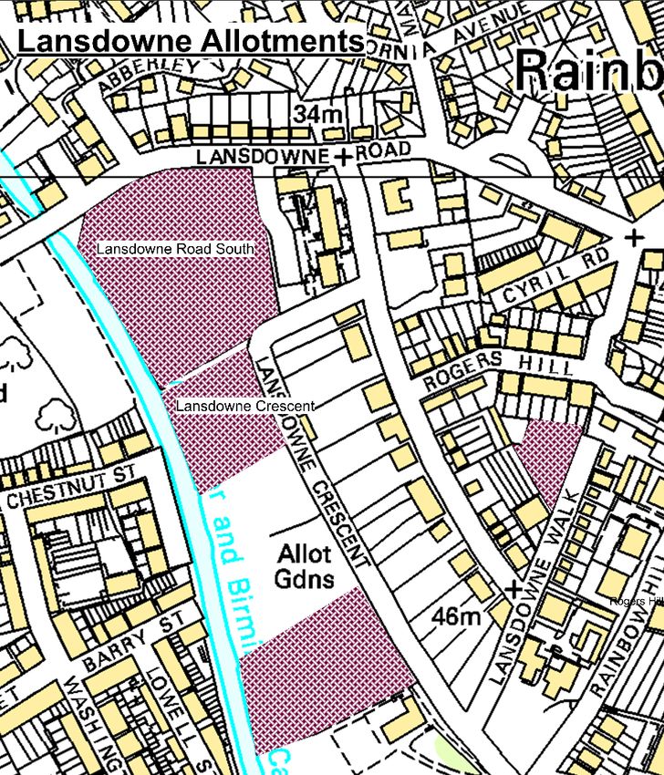
• Lansdowne Crescent Allotments is a
site in Worcester City best known for
large populations of slow-worms. It is
considered a ‘slow-worm’ sanctuary
by the Worcester City Council and
therefore has several shelters,
hibernating and hiding areas for the
species (Shepard, n.d.). Figure 10
shows size and location of the
Lansdowne Road South and
Lansdown. Crescent allotments. Figure 10 Lansdowne allotments in Worcester City.
14
Worcestershire Biodiversity Action Plan 2018
H14 Urban HAP• Lyppard Grange Ponds is a designated Special Area of Conservation (SAC) characterized by its
inland water bodies, heath, scrub, maquis and garrigue, phrygana, and improved grassland. SAC
SAC/SSSI. The Annex II species protected in the site is the great crested newt (Joint Nature
Conservation Committee, 2018). Lyppard Grange Ponds is also a designated Site of Special
Scientific Interest (SSSI) because it supports the largest known breeding colony of great crested
newts in the county (Lyppard Grange Ponds SSSI, 2000). The ponds are in Warndon Villages, a
recent housing development on former pastoral farmland, and isolated within the development
(Worcestershire Biodiversity Partnership, Great Crested Newt Species Action Plan, 2008).
• Malvern Hills, cared for by the Malvern Hills Trust, are covered with a wide variety of habitats –
grasslands, woodlands, scrub, grass, rock, wildflower meadows, ponds, mire, bog, quarries and
orchards (Malvern Hills Trust, 2018). The variety of habitats allows for a variety of species.
• Redditch is a great example of a town with good green infrastructure. When Redditch town was
planned and developed, an extensive network of woodlands, hedgerows, and meadows were
preserved or created for landscaping and recreation purposes. There are over 168 hectares of
woodlands in Redditch, some designed as Ancient or Semi-Natural Woodland (Redditch Borough
Council, 2018). The Worcestershire Wildlife Trust have written a vision for Redditch Borough. 7
• Severn Valley. “There are nine internationally designated sites in the National Character Area
(NCA). The area is particularly important in terms of the floodplain wetland and associated bird
assemblages, lowland meadow and traditional orchards. Most of the woodland is semi-natural
ancient woodland, and important invertebrate assemblages are supported by the veteran trees
of parkland such as that in the Bredon Hill SAC” (Natural England, National Character Area
profile: 106. Severn and Avon Vales, 2014).
• Teme Valley is an NCA located in the northwest region of Worcestershire. “There are 10 SSSI
covering 2 per cent of the NCA, including the River Teme and parts of the Wyre Forest SSSI. The
NCA contains important areas of priority habitats that include broadleaved woodland – ancient
semi-natural woodland forms 40 per cent of the woodland resource – lowland grassland and
traditional orchards that form part of the larger fruit-growing area in the counties of
Worcestershire, Herefordshire and Gloucestershire, supporting England’s main population and
concentration of noble chafer beetle, currently classified as vulnerable in the UK” (Natural
England, National Character Area profile: 102. Teme Valley, 2014).
• Wychavon District has been found to have the highest overall density of great crested newts in
the county, with a percentage occurrence in those ponds surveyed of 62%. One of the best
examples from within this area is Hanbury parish, where 32 ponds were surveyed and 26 of
7
The Worcestershire Wildlife Trust vision for Redditch: http://bit.ly/2CqqX7b
15
Worcestershire Biodiversity Action Plan 2018
H14 Urban HAPthese found to contain great crested newts (Watson, 2000). 26 of the ponds surveyed were on
the National Trust’s Hanbury Hall estate and 21 of these contained great crested newts
(Watson, The Status and Distribution of Great Crested Newts in Worchestershire 2000: part 2,
2001) (Worcestershire Biodiversity Partnership, Great Crested Newt Species Action Plan, 2008).
• Wyre Forest is the northern district in the Worcestershire County. Within the district are areas
of countryside, villages, and three towns – Kidderminster, Bewdley, and Stourport-on-Severn.
Wyre Forest is named for the Forest of Wyre (Wyre Forest District Council, 2017).
Figure 11 Map of Wyre Forest (Natural England, Wyre Forest: National Nature Reserve, 2010)
16
Worcestershire Biodiversity Action Plan 2018
H14 Urban HAP3 Current Pressures
3.1 Factors Affecting Habitats and Species
Management, development pressure, human activity, contamination, isolation and fragmentation, and
health and safety concerns all negatively affect the targets species habitats in various ways.
• Management. The quality and biodiversity potential of urban habitat can be overlooked, ignored
or inappropriately identified leading to deficiencies in management. In addition, much of the
urban habitat resource must meet the needs of multiple users and cannot always be managed in
the most appropriate manner to maximise biodiversity benefit.
• Development Pressure. Urban locations are very important ecologically and often contain
protected species. Unfortunately, such areas are also subject to significant development
pressure, in part because of Government policy on the re-use of brownfield sites. Such pressure
is leading to a decline in the overall habitat resource, but it can also act a driver for providing
biodiversity benefit within the built environment.
• Human Activity. There are many associated problems and benefits from this variable, including
the effect of domestic animals, especially cats, and the increased use of footpaths, parks etc.
• Contamination. Industrial pollutants may be present and can have a detrimental effect upon the
habitat, biodiversity and site users.
• Isolation and fragmentation. Many urban habitats suffer from fragmentation because of
development or changing land use. This combined with the small size of many sites can lead to a
decline in species diversity and population size even in situations where the habitats themselves
are well managed.
• Health and safety concerns. This can be a problem with respect to street trees and their
proximity to roads and public buildings.
Among all targeted species several factors affect the decline in populations because of the factors
described above: loss of hibernation and roosting habitats, poor management practices of farmlands,
grasslands, allotments, ponds and other waterways, use of pesticides and other toxic or poisonous
chemicals, and population fragmentation as a result of poor urban planning and development.
3.2 Slow-worm Case Study
During 1994 and 1995, slow-worm mitigation exercises took place in Kent at two locations. This exercise
yielded information about translocating populations away from sites in question, possibly planned for
new developments (Platenberg & Longton). Authors Platenberg and Longton discovered that it is
difficult to estimate populations of slow-worms due to irregular behavior and inaccurate models, which
only consider slow-worms removed and all other conditions constant.
17
Worcestershire Biodiversity Action Plan 2018
H14 Urban HAPOnce thought to mitigate vulnerable populations of slow-worms, translocating may not result in any
mitigation. According to Platenberg and Griffiths, “the conservation value of [translocating] is unproven
for many species” including the slow-worm (Platenberg & Griffiths, 1999). During their study, 103 slow-
worms were removed from the development site and relocated to a receptor site. However, after two
years, the monitored slow-worms showed “little evidence of successful reproduction” and were in
“poorer condition” than the surrounding slow-worms.
From these studies, alternative conservation methods are needed to protect urbanized species. GI is
designed to incorporate the environment into urban settings which may lead to natural migrations of
species from development sites. Instead of isolating small patches of species’ population, these habitats
can be interconnected with gardens, parks, or roadside trees to enhance habitats and natural species
migrations, hibernation, and roosting
4 Current Action
4.1 Delivering and Protecting GI through Policy and Legislation
• SAC Designation. Special Areas of Conservation (SACs) “are sites that have been adopted by the
European Commission and formally designated by the government of each country in whose
territory the site lies” (JNCC, 2018). The sites are established based on their contribution to
conserving 189 habitat types and 788 species identified in the European Commission (EC)
Habitats Directive (JNCC, 2018).
• SSSI Designation. Sites of Special Scientific Interest are nationally important and legally
protected natural sites that often exhibit some of the best and most beautiful wildlife habitats.
They account for about 7% of England’s land and many are also designated as SACs, Special
Protection Areas (SPAs), National Nature Reserves (NNRs), and/or Local Nature Reserves (LNRs)
(Natural England, Sites of Special Scientific Interest (SSSIs), 2008). SSSIs are protected through
cooperation between people who manage the sites and the government.
There are a number of legal designations relevant to Worcestershire’s urban environment.
• There is one European protected site, The Lyppard Grange in Worcester
• There are several SSSIs including Ipsley Alders March in Redditch and Northwick March in
Worcester
• There are also several urban Local Nature Reserves spread widely throughout Worcestershire
4.1.1 Worcestershire Local Sites (LS’s)
Worcestershire has 553 LS’s. LS fall outside the national statutory protection but are given protection
under local government policy. LS’s cover sites of biological or geological value and significant local
ecology and/or geology (Worcestershire County Council, Worcestershire Local Sites Partnership, 2018).
The Worcestershire Wildlife Trust manages 75 natures reserves throughout the county. The organization
aims to restore, recreate, and reconnect natural habitats by working with farmers, landowners, and
communities to encourage wildlife (Worcestershire Wildlife Trust, Find a nature reserve, 2018).
18
Worcestershire Biodiversity Action Plan 2018
H14 Urban HAPWorcester is home to 18 wildlife sites managed by the Worcester City Council’s Wildlife Ranger Team.
Over 120 hectares provide various habitats – ponds, ancient semi-natural woodland, unimproved
grassland and wildflower, meadows, scrub, reedbed and riverbanks – for numerous species. The wildlife
sites are important GI because they interconnect biodiversity throughout urban areas across the city and
county (Worcester City Council, 2018).
4.1.2 Local Plan Documents (LPDs)
Although the Worcestershire Biodiversity Action Plan provides information on targeted species and
habitats, local districts have established their own LPDs with brief policies on GI and biodiversity.
South Worcestershire Development Plan. Worcester City Council, Malvern Hills District Council, and
Wychavon District Council developed this plan together. In regard to biodiversity, the plan states that
development is not permitted if it would:
A. Compromise the favourable condition of a SAC or other international designations or the
favourable conservation status of European or nationally protected species or habitats,
B. Have an adverse effect on a SSSI, except where the benefits of the development at that site
clearly outweigh both its likely impact on the features of the site that make it of special scientific
interest and any broader impacts on the national network of SSSIs,
C. Result in the loss or deterioration of an Ancient Woodland (AW), a Veteran Tree (VT), or a
nationally protected species, unless the need and the benefits of the proposed development in
that location clearly outweigh the loss or deterioration, and
D. Compromise the favourable condition or the favourable conservation status of a Grassland
Inventory Site (GIS), a Local Wildlife Site (LWS), a Local Geological Site (LGS), an important
individual tree or woodland and species or habitats of principal importance recognised in the
Biodiversity Action Plan or listed under Section 41 of the Natural Environment and Rural
Communities Act 2006, unless the need for and the benefits of the proposed development
outweigh the loss.
The plan also states that development should, wherever practicable, be designed to enhance
biodiversity and geodiversity (including soils) conservation interests as well as conserve on-site
biodiversity corridors / networks. Developments should also take opportunities, where practicable, to
enhance biodiversity corridors / networks beyond the site boundary.
Regarding GI, the plan states:
A. Housing development proposals (including mixed-use schemes) are required to contribute
towards the provision, maintenance, improvement and connectivity of Green Infrastructure (GI)
as follows:
I. For greenfield sites exceeding 1ha (gross) – 40% GI
II. For greenfield sites of less than 1ha but more than 0.2ha (gross) – 20% GI
III. For brownfield sites – no specific GI figure.
B. The precise form and function(s) of GI will depend on local circumstances and the
Worcestershire Green Infrastructure Strategy’s priorities. Developers should seek to agree these
matters with the local planning authority in advance of a planning application. Effective
management arrangements should also be clearly set out and secured. Once a planning
19
Worcestershire Biodiversity Action Plan 2018
H14 Urban HAPpermission has been implemented, the associated GI will be protected as Green Space (SWDP
38 refers)
C. Other than specific site allocations in the development plan, development proposals that would
have a detrimental impact on important GI attributes within the areas identified as “protect and
enhance” or “protect and restore”, as identified on the Environmental Character Areas Map, will
not be permitted unless:
I. A robust, independent assessment of community and technical need shows the
specific GI typology to be surplus to requirements in that location; and
II. Replacement of, or investment in, GI of at least equal community and technical
benefit is secured.8
Bromsgrove District Plan. The Bromsgrove District Council developed this plan and adopted it in 2017.
The district is home to rich biodiversity and geodiversity, with particular species and habitats of interest,
such as water voles, bats, hay meadows, acid grasslands, VT’s, and canals. As such, strategic objective 8
states:
• Protect and enhance the unique character, quality, and appearance of the historic and natural
environment, biodiversity and Green Infrastructure throughout the District.
This plan also incorporates GI and how the council will deliver a high-quality GI multi-functional GI
network by:
a. ensuring developments adopt a holistic approach to deliver the multiple benefits and vital
services of Green Infrastructure, with priorities determined by local circumstances;
b. Requiring development to improve connectivity and enhance the quality of Green
Infrastructure;
c. Requiring development to provide for the appropriate long-term management of Green
Infrastructure;
d. Requiring development to have regard to and contribute towards, the emerging Worcestershire
Green Infrastructure Strategy, any local GI Strategy and where available, the GI Concept Plans.
For large scale development, developers will need to prepare a Concept Plan for the area, which
would then serve to inform all developments in that area as they come forward. 9
Borough of Redditch Local Plan No. 4. The Borough of Redditch developed several objectives to create
and sustain a green environment. The objectives are as follows:
• “To maintain and provide a high quality natural, rural and historic environment with a Green
Infrastructure network which maximises opportunities for biodiversity value, wildlife and
ecological connectivity”;
8
All excerpts were taken directly from the South Worcestershire Development Plan. 2016.
http://www.swdevelopmentplan.org/wp-content/uploads/2016/06/The-Adopted-SWDP-February-2016.pdf
Requirement E has been omitted from this section.
9
Excerpt taken directly from the Bromsgrove District Plan. 2017.
http://www.bromsgrove.gov.uk/media/2673698/Adopted-BDP-January-2017.pdf
20
Worcestershire Biodiversity Action Plan 2018
H14 Urban HAP• “To ensure that all new development in Redditch Borough will work towards the achievement of
being carbon neutral in line with the National Standards”;
• “To reduce the causes of, minimise the impacts of and adapt to climate change”;
• “To protect, promote and where possible enhance the quality of the Boroughs landscape and
Redditch Borough’s other distinctive features”;
• “To encourage safer, sustainable travel patterns, improve accessibility and maintain a balanced
road hierarchy and reduce the need to travel”;
• “To protect and enhance water, air and soil and minimise flood risk”.10
Wyre Forest Core Strategy (2006-2026). The Wyre Forest District Council developed and adopted a
Local Development Framework in 2010. Within the plan are statements for providing a GI network and
opportunities for local biodiversity and geodiversity. The Wyre Forest District plans to develop green
infrastructure by delivering a “comprehensive network of green spaces, corridors and stepping stones
across the District. This will help to promote active lifestyles, improve health and wellbeing, promote
walking and cycling as a means of sustainable transport, support biodiversity and help to deliver UK and
local BAP (Biodiversity Action Plan) targets and objectives, address climate change, and safeguard and
enhance the District's unique landscape character, including the historic environment. Green
infrastructure is an important cross-cutting issue. Therefore, this policy has linkages with CP14:
Providing Opportunities for Local Biodiversity and Geodiversity; CP01: Delivering Sustainable
Development Standards; CP07: Delivering Community Wellbeing; and CP15: Regenerating the
Waterways.11
The District also plans to provide opportunities for local biodiversity and geodiversity by:
• Safeguarding existing biodiversity sites – SSSI, NNR, LNR, SWS, and species and habitats
recognised in the Worcestershire BAP;
• Enhancing opportunities or contributing to off-site biodiversity project during new
development;
• Conserving and enhancing trees and woodlands under the protection of Tree Prevention Orders
(TPOs);
• Enhancing and not detrimentally impacting the geodiversity during new development.
4.2 Ongoing Management of GI Habitat Assets
Managing GI assets are important to the future and sustainability of environmental biodiversity. In the
Worcestershire Green Infrastructure Strategy, environmental quality categories are as follows:
• Protect and enhance (greatest existing GI value),
• Protect and restore (medium existing GI value), and
• Restore and create (lowest existing GI value) (Worcestershire Green Infrastructure Partnership,
2013).
10
Excerpt taken directly from Borough of Redditch Local Plan No.4. 2017.
http://www.redditchbc.gov.uk/media/2751956/Adopted-BORLP4-low-res-17-02-17.pdf
11
Excerpt taken directly from Core Strategy. 2010. http://www.wyreforestdc.gov.uk/media/89829/Adopted-Core-
Strategy-DPD.pdf
21
Worcestershire Biodiversity Action Plan 2018
H14 Urban HAPWorcestershire should continue to assess natural habitats based on this criterion because they prioritize
the value of GI. It also helps to identify green corridors, which link GI and strengthen the connections
between target species and habitats.
The Worcestershire County Council also created a paper on the viability of delivering GI as part of the
suite of GI Strategy documents. The report aims to provide “guidance on the viability, valuing, and
costing of GI to support implementation and delivery of GI on new development sites delivered through
the planning process” (Worcestershire County Council, 2015). It also recognizes that delivering GI is
impacted by the scale and type of scheme. Figure 12 demonstrates the funneling down scale of different
GI delivery projects and who is impacted by them.
Strategic or County GI
• These are large-scale projects which provide functions and facilities
which benefit more than one district or population within the county.
District GI
• These are schemes providing a range of functions at a district
level which benefit the population of the district.
Neighborhood or Local GI
• these are small-scale enhancements which would typically be
included within development site.
Figure 12 Delivering GI at different scales (modified from (Worcestershire County Council, 2015))
Assessing the viability of land development starts by asking: is the land development
economically/financially feasible? Planning for high quality, sustainable, and multifunctional GI may
increase developer’s financial return and the overall viability of the project. Determining the value of GI
allows for understanding the qualitative and quantitative benefits which help planners and developers
determine the appropriate GI’s. The value of GI can also help compare development sites. Finally, GI
needs funding for both initial development and long-term management and maintenance. The whole
document, Viability, valuation and funding of green infrastructure on new development sites, details
more on delivering GI in new development sites (Worcestershire County Council, 2015).
4.3 Taking Action for Priority Species in the Urban Environment
4.3.1 Sanders Park, Bromsgrove Case Study
The Battlefield Brook runs through Sanders Park and is home to one of only two populations of water
voles. The brook is a concrete channel, which has negatively affected the wildlife in the park over the
years. 2017 began the restoration project12 in part of a Severn Trent Water’s wider National
Environment Programme designed to improve the ecology of the brook, create a more natural
12
Full details of the project can be found here: https://sites.google.com/northmid.co.uk/battlefieldbrook
22
Worcestershire Biodiversity Action Plan 2018
H14 Urban HAPenvironment in the park, and help the brook reach ‘good’ status in accordance with the Water
Framework Directive (WFD) (Bromsgrove District Council, 2018).
4.3.2 Lansdowne Crescent Allotments
The Lansdowne Crescent Allotments are considered a ‘slow-worm’ sanctuary site by the Worcester City
Council. This cite should further be monitored by the council to determine further actions to help the
species in this urban environment.
4.4 Survey, Research, and Monitoring of GI Assets and Urban Wildlife
Monitoring of urban biodiversity has been somewhat piecemeal in the past but there have been several
important projects carried out in the county. In Worcester there have been surveys for slow worms and
great crested newts, a full appraisal of over 80 greenspaces and a comprehensive assessment of the
wider ‘green network’ of interconnecting open space and gardens.
Malvern Hills DC and Wychavon DC have carried out open space audits covering urban greenspace as
well as the wider countryside and Bromsgrove DC has initiated a survey for Arvicola terrestris water
vole.
The Worcester Wildlife Trust supports research and surveys throughout the county. In 2011, the
organization conducted a valuation case study of the Gwen Finch Wetland Reserve. The economic
evaluation showed that projects such as creation of Gwen Finch Wetland Reserve and The John Bennett
Reserve, are cost-effective (Holzinger & Dench, 2011). This finding supports implementing conservation
and management practices to ensure that target species and habitats, biodiversity altogether, are
protected in Worcestershire County.
The following actions for priority species are currently ongoing:
• Bromsgrove Water Vole Strategy. Resulting from surveys in Bromsgrove town the strategy sets
out a number of habitat management mechanisms and targets designed to protect and enhance
suitable water vole habitat along watercourses in the town.
• Worcester City Slow-Worm survey. Ongoing survey and site protection in the city designed to
protect and enhance the important populations found within the greenspace network.
23
Worcestershire Biodiversity Action Plan 2018
H14 Urban HAP5 References
Bat Conservation Trust. (2010). Common pipistrelle. London: Bat Conservation Trust.
British Parliament. (2008). Planning Policy Statement 12. London: TSO.
Bromsgrove District Council. (2018). New Developments. Retrieved from bromsgrove.gov.uk:
www.bromsgrove.gov.uk/things-to-do/parks-and-outdoors/parks-and-play-areas/sanders-
park/new-developments.aspx
Burch, S., Berry, P., & Sanders, M. (2012). Embedding climate change adaptation in biodiversity
conservation: A case study of England. Evironmental Science & Policy, 79-90.
City of London. (n.d.). City of London Biodiversity Action Plan 2016-2020. Legislation, London.
Conservation on Biological Diversity. (2018). About the Nagoya Protocol. Retrieved from Conservation
on Biological Diversity: https://www.cbd.int/abs/about/
Department for Environment Food and Rural Affairs. (2011). Biodiversity 2020: A strategy for England's
wildife and ecosystem services. The Crown.
Department of Environment Food and Rural Affair. (2012). The UK Post-2010 Biodiversity Framework.
Retrieved from JNCC: http://jncc.defra.gov.uk/page-6189
GreenFacts. (2001-2017). Biodiversity & Human Well-being. Retrieved from GreenFacts: Facts on Health
and the Environment: https://www.greenfacts.org/en/biodiversity/l-3/1-define-biodiversity.htm
HM Government. (2011). The Natural Choice: securing the value of naure. Crown.
Holzinger, O., & Dench, D. (2011). The Economic Evaluation of Gwen Finch Wetland Reserve. Worcester:
Worcestershire Wildlife Trust.
JNCC. (2018). Special Areas of Conservation (SAC). Retrieved from JNCC: http://jncc.defra.gov.uk/page-
23
Joint Nature Conservation Committee. (2018). Lyppard Grange Ponds. Retrieved from Joint Nature
Conservation Committee:
http://jncc.defra.gov.uk/protectedsites/sacselection/sac.asp?EUCode=UK0030198
Koc, C. B., Osmond, P., & Peters, A. (2016). A Green Infrastructure Typology Matrix to Support Urban
Microclimate Studies. Procedia Engineering, 183-190.
Lyppard Grange Ponds SSSI. (2000). Retrieved from Designated Sites View:
https://designatedsites.naturalengland.org.uk/SiteDetail.aspx?SiteCode=s2000428
Malvern Hills Trust. (2018). Habitats. Retrieved from Malvern Hill: http://www.malvernhills.org.uk/hills-
and-commons/habitats/
Natural England. (2008). Sites of Special Scientific Interest (SSSIs). Natural England.
Natural England. (2009). Green Infrastructure Guidance.
24
Worcestershire Biodiversity Action Plan 2018
H14 Urban HAPNatural England. (2010). Wyre Forest: National Nature Reserve. The Crown.
Natural England. (2014). National Character Area profile: 102. Teme Valley.
Natural England. (2014). National Character Area profile: 106. Severn and Avon Vales.
Park, C., & Allaby, M. (2017). biodiversity action plan . A Dictionary of Environment and Conservation ,
3rd. Oxford University Press. Retrieved from
http://www.oxfordreference.com.ezproxy.wpi.edu/view/10.1093/acref/9780191826320.001.00
01/acref-9780191826320-e-750
Parliament. (2012). National Planning Policy Framework. London: The Crown.
Platenberg, R. J., & Griffiths, R. A. (1999). Translocation of slow-worms (Anguis fragilis) as a mitigation
strategy: a case study from south-east England. Biological Conservation, 125-132.
Platenberg, R., & Longton, T. (n.d.). Slow-worms in Kent: estimates of population density and post-
translocatin monitoring. Natural England, 61-70.
Puppim de Oliveira, J. A., Doll, C. N., & Moreno-Penaranda, R. (2014). Urban Biodiversity and Climate
Change (Vol. 1). Springer, Dordecht. doi:https://doi.org/10.1007/978-94-007-5784-4_21
Redditch Borough Council. (2018). Woodland management programme. Retrieved from
redditchbc.gov.uk: http://www.redditchbc.gov.uk/my-place/landscape-and-trees/tree-
maintenance/woodland-management-programme.aspx
Rescue, W. H. (2010). Access4Hedgehogs. Retrieved from Willows Hedgehog Rescue Broomsgrove:
http://www.willowshedgehogrescue.co.uk/willows-access-for-hedgehogs.html
Shepard, A. (n.d.). Urban Slow-worms in Worcester City. Retrieved from
http://www.wbrc.org.uk/WORCRECD/Vol1Iss3/slowworm.htm
University of California Museum of Paleontology. (2018). Biological species concept. Retrieved from
Understanding Evolution:
https://evolution.berkeley.edu/evolibrary/article/side_0_0/biospecies_01
Watson, W. (2000). The Status and Distribution of Great Crested Newts in Worcestershire 2000: part 1.
Worcestershire Records(9).
Watson, W. (2001). The Status and Distribution of Great Crested Newts in Worchestershire 2000: part 2.
Worcestershire Record(11).
Worcester City Council. (2018). Wildlife Sites in Worcester CIty. Retrieved from Worcester City Coucnil:
https://www.worcester.gov.uk/conservation-wildlife-sites
Worcestershire Biodiversity Partnership. (2008). Bat Species Action Plan. Woecester: Worcestershire
County Council.
Worcestershire Biodiversity Partnership. (2008). Great Crested Newt Species Action Plan. Worcester:
Worcestershire County Council.
25
Worcestershire Biodiversity Action Plan 2018
H14 Urban HAPYou can also read