Integrated Transport Study Report - 25/05/2016 Knox Central Integrated Transport Study
←
→
Page content transcription
If your browser does not render page correctly, please read the page content below
Integrated
                                                         Transport
                                                     Study Report
                                                         25/05/2016

CG150966   Knox Central Integrated Transport Study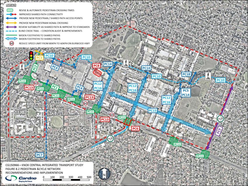
Knox Central Integrated Transport Study – Report
Prepared for Knox City Council

                                                                                                                                                                              Cardno Victoria Pty Ltd
                                                                                                                                                                                    Trading as Cardno
                                                                                                                                                                                 ABN 47 106 610 913

                                                                                                                                                                                               Level 4
                                                                                                                                                                                  501 Swanston Street
                                                                                                                                                                                            Melbourne
                                                                                                                                                                                Victoria 3000 Australia

                                                                                                                                                                           Telephone: (03) 8415 7777
                                                                                                                                                                            Facsimile: (03) 8415 7788
                                                                                                                                                                      International: +61 3 8415 7777

                                                                                                                                                                                victoria@cardno.com.au
                                                                                                                                                                                       www.cardno.com

Document Control
Version                            Date                              Author                                                              Reviewer
F01                                25/05/2016                        Matthew Mudge                     MM                                Adrian Wanasili                   AW

© Cardno. Copyright in the whole and every part of this document belongs to Cardno and may not be used, sold, transferred, copied or reproduced in whole or in part in any manner or form or in or on any
media to any person other than by agreement with Cardno. This document is produced by Cardno solely for the benefit and use by the client in accordance with the terms of the engagement. Cardno does
not and shall not assume any responsibility or liability whatsoever to any third party arising out of any use or reliance by any third party on the content of this document.

May 2016                                                                                                 Cardno Victoria Pty Ltd                                                                            i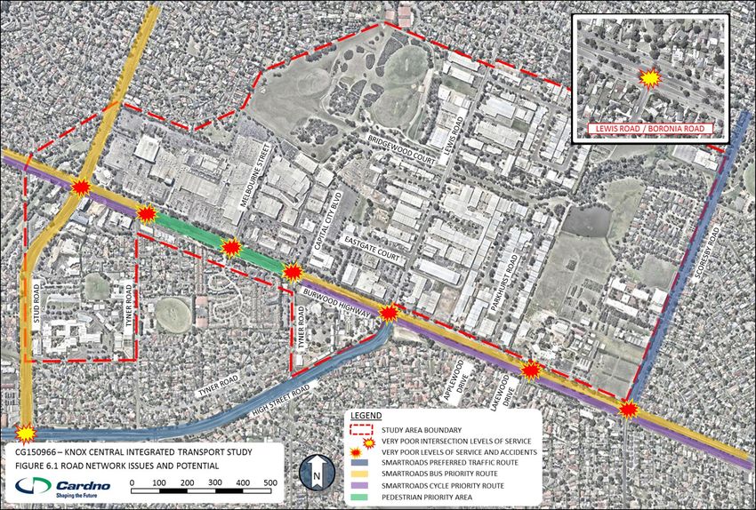
Knox Central Integrated Transport Study – Report
Prepared for Knox City Council
Executive Summary Knox Central Site Location & Key Land Uses
Introduction
Knox City Council is currently preparing a Structure Plan for the Knox Central Activity
Centre (Knox Central), with the purpose of updating and building upon recommendations
identified in the Knox Central Urban Design Framework 2005 (KCUDF).
The purpose of this Integrated Transport Study (ITS) is to identify deficiencies and areas of
opportunity in the Knox Central study area in order to develop a framework for the future
investment in transport network improvements, including public transport and active
transport, as development increases and the demand across all modes of transport grows.
This ITS identifies existing transport issues and opportunities, and provides
recommendations for potential future investment projects in the short term and into the
future. These recommendations are intended to provide a transport network that is ‘fit-for-
purpose’ as development in the study area places additional pressure on the network.
ITS Development Context
Planning Context
Location & land use
The recommendations identified in this ITS are intended to support the Knox Central
The Knox Central Activity Centre is located approximately 35 kilometres east of the Structure Plan whilst satisfying the key objectives set out in State and Local Government
Melbourne CBD and has an area of approximately 200 hectares. It is generally bounded by land use, development, and transport policy that include but aren’t limited to:
Scoresby Road to the east, Burwood Highway / Swinburne TAFE / St Andrews College to
the south, Stud Road to the west and Westfield Knox / Lewis Park to the north. The Transport Integration Act (2010), which was introduced in 2010 to create a
framework for the provision of an integrated and sustainable transport system in
The study area comprises a wide range of land uses that result in a cosmopolitan Activity Victoria;
Centre precinct. Notably, Westfield Knox is the key attractor of visitors to the study area,
providing a mix of retail and commercial uses. Key land uses within Knox Central include: Plan Melbourne, which is the current Metropolitan Planning Strategy; an integrated
land use and transport plan developed by the State Government and adopted in May
Retail (Primarily Westfield Knox) 2014;
Education (Primary, Secondary, Tertiary, including Private education);
Aged Care; SmartRoads, a road network management approach developed by VicRoads which
Government (Department of Environment, Land, Water & Planning (DELWP); recognises the increasing importance of public transport, walking and cycling as
Industrial / Commercial (Warehouse, Manufacturing, and Servicing operations); transport modes;
Residential (Low to High Density); The Knox Central Urban Design Framework (KCUDF) was prepared for the Knox
Civic (Knox Civic Centre – Council Offices and Operations Centre); and Central Precinct and endorsed in 2005 with the key aim of outlining the built form
Open Space / Recreational (Blind Creek Trail, Lewis Park, and sporting facilities). principles required to support a thriving, lively focal point and mixed use activity
centre for the outer eastern suburbs.
May 2016 Cardno Victoria Pty Ltd ii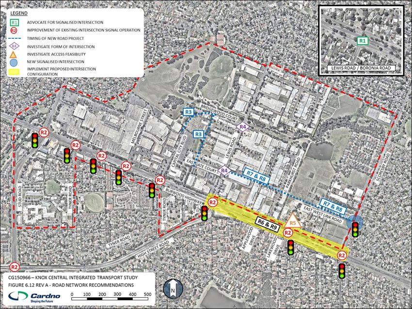
Knox Central Integrated Transport Study – Report
Prepared for Knox City Council
Transport strategies outlined in the Knox City Council Planning Scheme; divided carriageway with 3 through traffic lanes in each direction. There are generally
The Knox Integrated Transport Plan 2015 – 2025 (ITP) , which provides a auxiliary turning lanes and a landscaped median provided between the intersections within
framework for both the development and management of an integrated transport the study area.
network to service the future needs of the Knox community and local business Stud Road is an Arterial Road aligned in a north-south direction which runs from Mountain
Transport aspirations identified in the Knox Vision: Our City, Our Future 2013- Highway in Bayswater to the north to Clow Street in Dandenong to the south. Stud Road
2017 document, which intends to provide a picture of the future City that will deliver typically provides for three traffic lanes in each direction separated by a landscaped median.
the lifestyle, jobs and industry, health and wellbeing desired by members of the Knox Scoresby Road is an Arterial Road also aligned in a north-south direction which extends
community. The Knox City Plan 2013-2017 provides transport strategies to support from Ferntree Gully Road in the south to Mountain Highway and beyond in the north.
the Knox Vision. Scoresby Road provides an undivided carriageway with two lanes in each direction at Knox
Central. Auxiliary turn lanes are provided where appropriate. A signalised pedestrian
Integrated Transport Study Findings and Recommendations crossing is provided on Scoresby Road, approximately 300m north of the intersection with
The following sections outline the existing transport network with issues and opportunities Burwood Highway, to facilitate pedestrian movements to and from Fairhills High School.
identified for each transport mode. A set of network improvement recommendations for
High Street Road is an arterial road extending west from Burwood Highway to St Kilda
each mode have also been identified and included with an implementation plan.
Road in Prahran. High Street Road has been upgraded between Stud Road and Burwood
Road Network Assessment highway to provide a two traffic lanes in each direction on a dual carriageway.
The observed and future road network issues and requirements were identified, and have Lewis Road is a key local road which provides a north-south connection through Knox
helped define a proposed road network through Knox Central. This network was also Central, extending south from High Street Road at Burwood Highway to Boronia Road.
developed using results from strategic traffic modelling. With this strategic road network Tyner Road is a local road essentially comprising a loop road within Burwood Highway,
identified, sections of the network were refined through the assessment of a number of Stud Road and High Street Road, connecting the residential, aged care and educational
intersection improvement options. areas within to Burwood Highway and High Street Road. Tyner Road has a single traffic
This section goes on to identify a set of recommendations to be implemented over time in lane in each direction in addition to a kerbside parking lane on one side only.
order to provide the road network that will be required to address the current issues and Parkhurst Drive is a local road serving an industrial area which is accessed from a
provide for the additional demand as Knox Central continues to develop. Burwood Highway service road and extends north from Burwood Highway then looping
Existing Road Network back onto itself. Parkhurst Drive is characterised by the industrial land use on both sides.
Knox Central sits east-west along the Burwood Highway Arterial Route between the north- Signals are provided at the key intersections on Burwood Highway with Stud Road, Tyner
south Arterial Routes Stud Road to the west and Scoresby Road to the east. The internal Road, High Street Road, Scoresby Road and a number of access points to Westfield Knox.
study area road network further consists of local Connector and Access Streets that
connect the site to the surrounding Arterial Road network. Key road network links are
outlined below,
Burwood Highway is an Arterial Road aligned generally in an east-west direction from
Monbulk Road in Belgrave to Warrigal Road in Burwood where it continues as Toorak Road
to the Melbourne CBD. Within the Knox Central study area, Burwood Highway is currently a
May 2016 Cardno Victoria Pty Ltd iii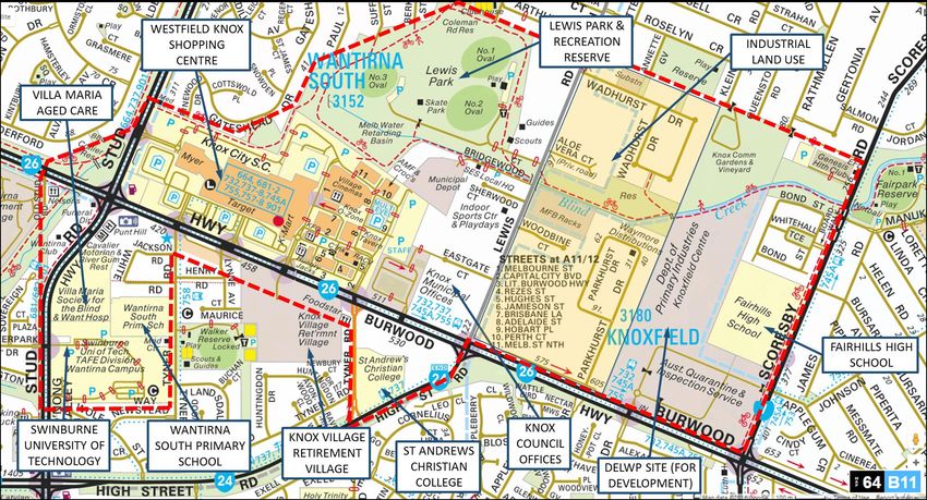
Knox Central Integrated Transport Study – Report
Prepared for Knox City Council

Road Network Issues & Opportunities                                                                     Lewis Road – Boronia Road Intersection - The Lewis Road/Boronia Road intersection to
The existing road network issues that have been identified throughout Knox Central are                  the north of Knox Central is currently operating at capacity under existing traffic conditions.
summarised in the table below, and are shown on the following figure.                                   Traffic modelling indicates that signalising the intersection would provide additional
                                                                                                        capacity at the intersection that would relieve current congestion in the short term and also
Existing Road Network Issues                                                                            allow for traffic growth in the longer term.

Reference      Road Network Issue                                                                       Eastgate Court to Bridgewood Court Link - It is understood that a number of
                                                                                                        intersections on the road network within Knox Central will require upgrading to allow new
I1             The intersections on Burwood Highway within the Knox Central study area                  road connections and to allow for increased traffic growth at existing connections.
               all currently operate with very poor levels of service resulting in significant          Introduction of the north south link between Eastgate Court and Bridgewood Court will
               queuing on the approaches during peak periods.                                           change traffic conditions in the Lewis Road and Capital City Boulevard area. Improvement
                                                                                                        measures may include the provision of roundabouts and priority intersection measures.
I2             The Stud Road / High Street Road intersection to the south of the study
               area operates above capacity during the peak periods, resulting in long                  East – West Link Road - As future growth in the area results in increased traffic being
                                                                                                        generated within the study area, the need for an east west link through Knox Central
               queues on all approaches during the peak times.
                                                                                                        becomes apparent. This link will provide additional connectivity to the surrounding arterial
I3             The Boronia Road / Lewis Road intersection to the north of the study area is             road network. Traffic modelling has suggested that the link between Lewis Road and
               significantly over capacity and warrants signalisation in the short term.                Scoresby Road may be implemented in a staged manner, with a section from Scoresby Road
                                                                                                        to Parkhurst Drive provided in the first instance. An extension to Lewis Road to further
I4             There is a high concentration of road accidents at intersections along                   improve permeability and the distribution of traffic through the study area should be
               Burwood Highway, including incidents involving pedestrians and cyclists,                 provided at a later time.
               particularly between High Street Road and Stud Road.                                     DELWP Access Connections - The development identified within the DELWP masterplan
                                                                                                        and the increased industry generated traffic in the area around Lewis Road and Parkhurst
I5             The VicRoads SmartRoads Road User Hierarchy for the study area indicates
                                                                                                        Drive will provide a need for new and improved connections from those locations to
               that the Burwood Highway and Stud Road are nominated as a ‘Bus Priority                  Burwood Highway and Scoresby Road. The nature and timing of these connections will be
               Route’ through the study area, as well as ‘Bicycle Priority Routes’ through              determined by the feasibility of the proposed access locations outlined in the DELWP
               Knox Central. Burwood Highway between the Tyner Road (loop)                              masterplan and also through consultation with and endorsement from VicRoads.
               intersections is also a nominated ‘Pedestrian Priority Route’. It will be                Burwood Highway Intersections between High Street Road and Scoresby Road - The
               necessary to continue to balance the accessibility needs for all modes on the            intersection modelling has also identified opportunities to streamline the existing
               road network through Knox Central, particularly along the Burwood                        intersections on Burwood Highway, particularly by allowing simultaneous right turn
               Highway.                                                                                 movements from the north and south legs at the intersections with High Street Road and
                                                                                                        Scoresby Road.

These issues have been highlighted on the following Plan

May 2016                                                                                  Cardno Victoria Pty Ltd                                                                                         iv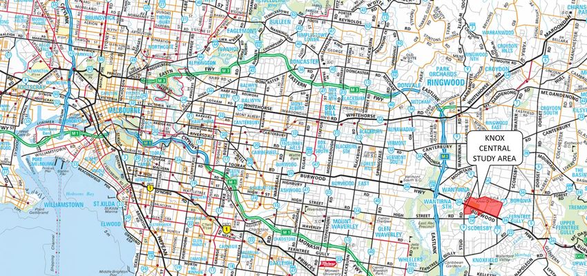
Knox Central Integrated Transport Study – Report
Prepared for Knox City Council

Identified Road Network Issues and Potential

May 2016                                           Cardno Victoria Pty Ltd   v
Knox Central Integrated Transport Study – Report
Prepared for Knox City Council

Road Network Recommendations
The identification of the road network issues and opportunities through the existing conditions analysis, the traffic modelling process, and consultation with Council officers allowed the following
recommendations to be determined. These are presented in the table below with the priority in terms of delivery and the responsibility for the delivery. An indication of how these
recommendations address the identified issues is also shown. These recommendations have also been identified where appropriate in the following road network recommendations figure.
Road Network Recommendations and Implementation
Item Ref        Project Description / Recommendation                                                                                            Responsibility           Priority      Issues
                                                                                                                                                                                       Addressed
R1         Advocate to VicRoads for the signalisation of the Lewis Road/Boronia Road intersection, and implement VicRoads endorsed              VicRoads / Knox          Short         I3
           intersection layout and signal plans.                                                                                                City Council             Term
R2         Advocate to VicRoads to undertake intersection timing and phasing analysis at key intersections on Burwood Highway and Stud          VicRoads / Knox          Short         I1, I2
           Road to identify improvements in the performance of the existing intersection arrangements.                                          City Council             Term
R3         Further investigate the timing and nature of the proposed north south link road connecting Eastgate Court, Bridgewood Court,         Knox City Council        Short         Future
           and Capital City Boulevard.                                                                                                                                   Term          Network
R4         Further investigate the form of intersection connections that can be feasibly provided to Lewis Road north of Burwood                Knox City Council        Short         Future
           Highway, and the proposed north-south link, particularly at the intersections with Bridgewood Court and Eastgate Court.                                       Term          Network
R5         Investigate whether the preferred access to the existing Lakewood Drive/Burwood Highway intersection through the DELWP               Knox City Council        Short         Future
           site as proposed in the draft DELWP precinct masterplan is feasible.                                                                                          Term          Network
R6         Consult with VicRoads to determine an acceptable configuration for the intersections on Burwood Highway between High Street          VicRoads / Knox          Short         I4, I5
           Road and Scoresby Road, considering the options tested in this study.                                                                City Council             Term
R7         Investigate the feasibility of providing a staged construction of the identified East-West road connection between Scoresby          Knox City Council        Medium        Future
           Road and Lewis Road, and the timing of the implementation of the stages as part of the detailed planning for the DELWP site.                                  Term          Network
R8         Design and construct the East-West link road as per the recommendations identified in the feasibility study recommended in R7.       Knox City Council        Long Term     Future
                                                                                                                                                                                       Network
R9         Implement the VicRoads endorsed intersection configuration along Burwood Highway between Lewis Road and Scoresby Road.               VicRoads / Knox          Medium –      I4, I5
                                                                                                                                                City Council             Long Term

These recommendations are also illustrated on the following plan.

May 2016                                                                                 Cardno Victoria Pty Ltd                                                                                        vi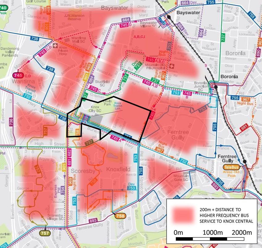
Knox Central Integrated Transport Study – Report
Prepared for Knox City Council

Plan of Road Network Recommendations

May 2016                                           Cardno Victoria Pty Ltd   vii
Knox Central Integrated Transport Study – Report
Prepared for Knox City Council

Public Transport Assessment                                                                         Reference   Public Transport Issue
Existing Public Transport Network                                                                   I8          While there is currently not the existing road network or demand for
Knox Central is serviced solely by bus services, with Westfield Knox operating as the bus                       services internal to the Knox Central study area, there will be an opportunity
interchange for a number of local and more strategic bus services. Bus service frequencies                      in the future to provide an east west service through the precinct that will
accessing Knox Central vary considerably, coupled with the current network coverage,                            provide access to future commercial and residential development in Knox
leave significant gaps in the network                                                                           Central.
The closest railway stations to the study area are Bayswater Station (approximately 3.5km           I9          A number of bus stops servicing Knox Central do not provide shelters or
north-east) and Boronia Station (approximately 2.5km north-east).                                               adequate service information, which may discourage use of the buses at
                                                                                                                night or during inclement weather. A particular area of concern is the stop
The nearest tram route to the study area is Route 75 Tram (Etihad Stadium Docklands to
                                                                                                                on Scoresby Road near the Fairhills School.
Vermont South), which terminates at Burwood Highway / Hanover Road, Vermont South,
approximately 5km west of the study area. The Knox Transit Link (Bus Route 732)                     I10         The Route 75 tram service from the CBD terminates at Burwood Highway /
connects to Tram Route 75 at the Vermont South terminus to Westfield Knox Shopping                              Hanover Road, in Vermont South, approximately 5km west of Knox Central.
Centre site, this service meets every tram service at the Vermont South terminus.                               There is an opportunity to extend the tram service to Knox Central in the
                                                                                                                future.
Public Transport Issues & Opportunities
The existing public transport issues that have been identified throughout Knox Central are
summarised in the table below, and are shown on the following figure.
Existing Public Transport Issues and Potential
Reference      Public Transport Issue
I6             A number of the bus routes that access the study area from local
               catchments have a very poor frequency. These include route numbers 757
               and 758 from the south and a number of key bus services (routes 664 and
               738) from surrounding activity centres and transport hubs such as
               Bayswater, Vermont and Mitcham.
I7             There are a number of service gaps in the network accessing Knox Central,
               including areas of Wantirna, Bayswater, Boronia, Knoxfield and Scoresby.
               There is a significant gap in the service along Scoresby Road between
               Bayswater and the intersection at Burwood Highway.

May 2016                                                                              Cardno Victoria Pty Ltd                                                                                    viii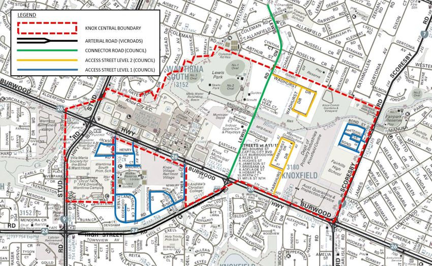
Knox Central Integrated Transport Study – Report
Prepared for Knox City Council

Identified Public Transport Network Issues and Potential

May 2016                                                   Cardno Victoria Pty Ltd   ix
Knox Central Integrated Transport Study – Report
Prepared for Knox City Council
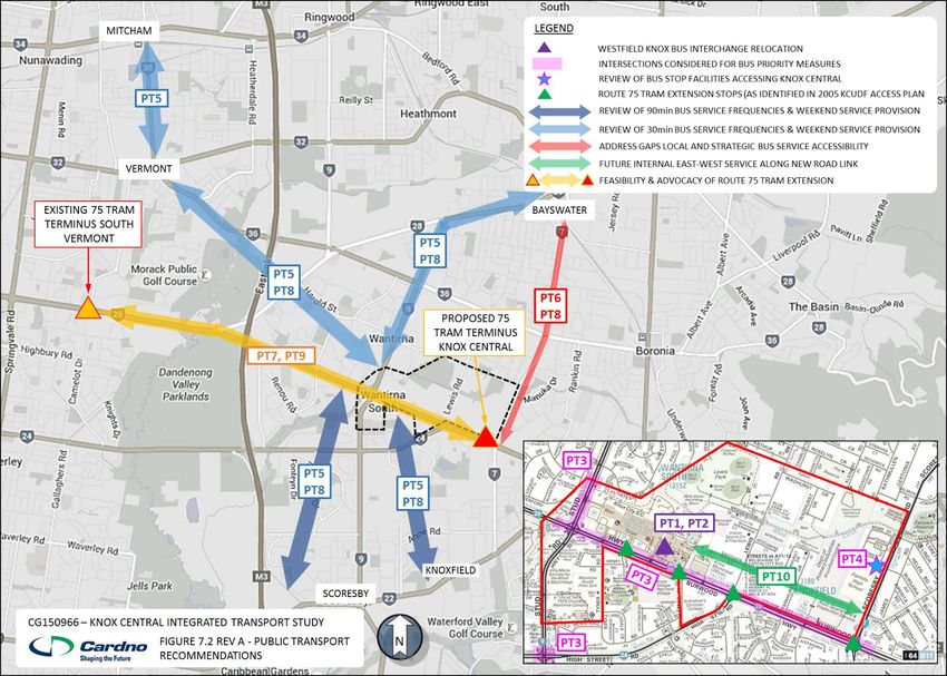
Public Transport Recommendations
The identification of the public transport issues and opportunities through the existing conditions analysis, and consultation with Council officers allowed the following recommendations to be
determined. These are presented in the table below with the priority in terms of delivery and the responsibility for the delivery. An indication of how these recommendations address the identified
issues is also shown. These recommendations have also been identified where appropriate in the following public transport recommendations figure.
Public Transport Recommendations and Implementation
Item Ref Project Description / Recommendation Responsibility Priority Issues
Addressed
PT1 Support the relocation of the bus interchange as proposed under the Westfield Knox Stage 1 development. PTV / Knox City Short Future
Council Term Network
PT2 Liaise and coordinate with PTV to undertake a public transport awareness campaign associated with the relocation of the PTV / Knox City Short Future
bus interchange at Westfield Knox. Council Term Network
PT3 Investigate the potential to improve bus priority measures at intersections along Burwood Highway and Stud Road accessing PTV / Knox City Short I6, I7, I8
the relocated bus interchange within Westfield Knox. Council Term
PT4 Liaise and work with PTV to improve service information and the provision and maintenance of shelters at appropriate bus PTV / Knox City Short I9
stops on the surrounding network. Council Term
PT5 Liaise and work with PTV to assess the need to increase service frequencies on identified routes across the bus network PTV / Knox City Short I6
servicing Knox Central. Council Term
PT6 Liaise and work with PTV to further investigate and identify gaps in the local bus network to improve accessibility to bus PTV / Knox City Short I7
services to Knox Central and neighbouring activity centres including the Wantirna Health Precinct. Council Term
PT7 Undertake a feasibility study into the need and viability of the Route 75 tram extension along Burwood Highway to Knox PTV / Knox City Medium I10
Central. Council Term
PT8 Advocate the delivery of network frequency and coverage improvement projects identified in the short term. PTV / Knox City Medium I6, I7
Council Term
PT9 Advocate for the delivery of the Route 75 tram route extension. PTV / Knox City Short I10
Council Term
PT10 Design and construct the East-West link road as per the recommendations identified in the feasibility study recommended in Knox City Long I8
R7. Council Term
May 2016 Cardno Victoria Pty Ltd xKnox Central Integrated Transport Study – Report Prepared for Knox City Council Public Transport Recommendations May 2016 Cardno Victoria Pty Ltd xi
Knox Central Integrated Transport Study – Report
Prepared for Knox City Council

Pedestrian and Cycle Network Assessment                                                               Reference   Pedestrian and Cycle Network Issue
Existing Pedestrian and Cyclist Network                                                                           according to VicRoads to provide any further connections to the surrounding
Foot paths are typically located on both sides of the road within Knox Central, and shared                        network beyond this point.
paths are provided along sections of Burwood Highway, Stud Road and Scoresby Road.                    I14         An informal pedestrian route has formed across the front of a loading zone
There is currently very limited dedicated on-road cycle facilities throughout Knox Central.                       at the north-east corner of the Westfield Knox site creating a hazard of
The existing bicycle network is primarily comprised of the shared path provision.                                 pedestrians and service vehicles.
The Blind Creek Trail forms the ‘spine’ of pedestrian and bicycle movements through Knox              I15         Pedestrians and cyclists using Blind Creek Trail currently have to cross Stud
Central, providing an east west link throughout the study area. Underpasses are typically                         Road where they are required to utilised the traffic signals at the Westfield
provided to spatially separate the pedestrian cross movements from major vehicular routes                         Knox access. This includes traversing an unsignalised left turn slip lane at
(Scoresby Road, Lewis Road and Burwood Highway).                                                                  the intersection, creating a conflict point with oncoming vehicles.
Blind Creek Trail does disconnect at Stud Road where pedestrians and cyclists must                    I16         The shared path on Scoresby Road is currently in poor condition, with
currently cross a slip lane accessing Westfield Knox, to utilise the traffic signals on Stud                      uneven concrete surface and overgrown planting and other obstacles, likely
Road to continue along the Blind Creek. It is proposed to improve this disconnect as part of                      to discourage use of the path by cyclists.
the Stage 1 development of the Westfield Knox site.                                                   I17         There are currently a number of underpasses on Blind Creek Trail that do
As part of the High Street Road duplication, signalised pedestrian crossings have been                            not have signs or warning markings, creating a hazard for cyclists.
provided on High Street Road. A three metre shared path has also been constructed along
                                                                                                      I18         There is a lack of north south cycle links through Knox Central, however an
the southern side of High Street Road between Burwood Highway and Stud Road.
                                                                                                                  informal desire line currently exists to Blind Creek Trail from the northern
Pedestrian and Cycle Network Issues & Opportunities                                                               end of Parkhurst Drive. A link at this location would help promote cycling as
The existing pedestrian and cycle network issues that have been identified throughout Knox                        a means of transport for workers employed in the industrial estates.
Central are summarised in the table below, and are shown on the following figure.                     I19         Existing narrow paths surrounding the Knox Westfield Shopping Centre do
Existing Pedestrian and Cycle Network Issues and Potential                                                        not encourage bicycle movements to/from or across the site.
                                                                                                      I20         There is an opportunity to further integrate pedestrian and cycle network
Reference      Pedestrian and Cycle Network Issue
                                                                                                                  connectivity and facilities through Knox Central with the proposed east
I11            There are insufficient pedestrian crossing times at signalised intersections                       west road network link.
               along Burwood Highway to cater for pedestrians with limited mobility or
                                                                                                      I21         There is also potential to further integrate pedestrian and cycle connections
               children. This is a particular concern given the land uses south of Burwood
                                                                                                                  through Knox Central with the proposed north south road network links
               Highway including aged care facilities and schools.
                                                                                                      I22         There is currently a lack of end of trip facilities for cyclists at key trip
I12            Pedestrian phases are currently not automatic at intersections along
                                                                                                                  generators within Knox Central
               Burwood Highway and need to be activated by the push button.
                                                                                                      I23         There is a lack of dedicated on-road bicycle lanes within Knox Central, and
I13            The new shared path on the southeast corner of the Burwood Highway /
                                                                                                                  across Knox more broadly.
               High Street Road intersection is discontinuous. There are no current plans

May 2016                                                                                Cardno Victoria Pty Ltd                                                                                   xii
Knox Central Integrated Transport Study – Report
Prepared for Knox City Council
Pedestrian and Cycle Network Recommendations
The identification of the pedestrian and cycle network issues and opportunities through the existing conditions analysis, and consultation with Council officers allowed the following
recommendations to be determined. These are presented in the table below with the priority in terms of delivery and the responsibility for the delivery. An indication of how these
recommendations address the identified issues is also shown. These recommendations have also been identified where appropriate in the following pedestrian and cycle network
recommendations figure.
Pedestrian and Cycle Network Recommendations and Implementation
Item Ref Project Description / Recommendation Responsibility Priority Issues
Addressed
PC1 Widen the footpath on the northern side of Burwood Highway between Stud Road and Melbourne Road to function as a Westfield Short I19
shared bicycle / pedestrian path. Term
PC2 Widen the footpath on the eastern side of Stud Road between the Blind Creek Trail link and Burwood Highway to function Westfield Short I19
as a shared bicycle / pedestrian path. Term
PC3 Provide a pedestrian crossing on each carriageway where the Blind Creek Trail meets Stud Road to provide direct Westfield Short I15
connectivity for the trail. Term
PC4 Provide additional pedestrian and shared path access points from Westfield Knox to the external foot or shared paths to Westfield Short I19
the north and south of the shopping centre. Provide proposed additional cycle parking facilities as per Stage 1 development Term
plan for Westfield Knox.
PC5 Provide a link between Parkhurst Drive and Blind Creek Trail and through to the Community Garden / Old Orchard Winery Knox City Short I18
site north of Blind Creek Trail at the existing desire lines to formalise access for pedestrians and cyclists through this area. Council Term
PC6 Determine measures to improve shared path connectivity from High Street Road to north of Burwood Highway and Knox City Short I13
implement measures identified. Council / Term
VicRoads
PC7 Improve wayfinding to shopping centre at new pedestrian crossing on High Street Road between Wolf Street and Wallace Knox City Short Future
Road. Council Term Network
PC8 Provide a short term measure to direct pedestrians away from the entrance to the loading dock on Melbourne Road along Westfield Short I14
the north-east corner of the Knox City. Term
PC9 Undertake a review of the shared path along the western side of Scoresby Road to include the provision of signage, the Knox City Short I16
foot/cycle path condition, and its suitability as a shared path and identify improvement measures and implement the Council Term
proposed measures.
May 2016 Cardno Victoria Pty Ltd xiiiKnox Central Integrated Transport Study – Report
Prepared for Knox City Council
Item Ref Project Description / Recommendation Responsibility Priority Issues
Addressed
PC10 Commission Blind Creek Trail audit, and implement identified improvement measures. Knox City Short I17
Council Term
PC11 Increase crossing times and automate pedestrian phases at the identified signalised intersections on Burwood Highway. VicRoads / Short I11, I12
Knox City Term
Council
PC12 Commission a study to investigate north-south cycle links through the study area north of Burwood Highway, including Knox City Medium I18
Lewis Road and Parkhurst Drive. Council Term
PC13 Advocate to VicRoads regarding reducing the speed limit along Burwood Highway between Stud Road and High Street Knox City Medium I11
Road from the existing 80km/h to 60 km/h in order to improve safety for pedestrians and cyclists crossing the road, Council / Term
particularly through the SmartRoads pedestrian activity zone. VicRoads
PC14 Provide additional north-south access points to Blind Creek Trail to service new and existing development. Knox City Medium I18, I21
Council / Term
Developers
PC15 Integrate pedestrian and cycle facilities into the proposed East-West link road. Knox City Long I20
Council Term
PC16 Integrate north south cycle link proposals into existing and proposed road network as identified through in the study Knox City Long I20
outlined in PC12. Council Term
PC17 Consider on-road bicycle lanes in future reviews of bicycle infrastructure across Knox. Knox City Medium I23
Council Term
PC18 Provide a link between Blind Creek Trail and the Community Garden / Vineyard site to provide access for pedestrians and Knox City Long I18
cyclists through this area. Council Term
May 2016 Cardno Victoria Pty Ltd xivKnox Central Integrated Transport Study – Report Prepared for Knox City Council Pedestrian & Cycling Recommendations May 2016 Cardno Victoria Pty Ltd xv
Knox Central Integrated Transport Study – Report
Prepared for Knox City Council
Car Parking Assessment Reference Car Parking Issue
Existing Parking Provision I25 Car parking generated by the industrial area increasing and spilling into
There is considerable parking provided within Knox Central, as. Westfield Knox currently surrounding streets with Knox Central and beyond.
provides approximately 6,300 free parking spaces for customers, including dedicated
I26 Car ownership outstripping the statutory supply requirements for new
accessible and parents with pram spaces. There are multiple access points off Stud Road
residential development in Knox Central, resulting in on-street resident
and Burwood Highway to the Westfield Knox car park facilities.
parking demand.
Outside of Westfield Knox, there is also a considerable amount of dedicated and on-street
parking provided including:
Knox City Council staff and visitor off street parking;
DELWP site staff parking;
Fairhills High School staff parking;
Parkhurst Drive and Lewis Road industrial estates – combination of on street and off
street parking reserved for each tenancy;
Bond Street / Whitehall Terrace residential on-street parking
Utilisation of on-street car parking provisions were observed to be typically moderate, with
the exception of Parkhurst Drive which experiences high utilisation, which is common for an
industrial precinct.
Car Parking Issues & Opportunities
The existing car parking issues that have been identified throughout Knox Central are
summarised in the table below, and are shown on the following figure.
Potential Car Parking Issues
Reference Car Parking Issue
I23 Potential parking overspill from Westfield Knox into surrounding Knox
Central streets and car parks and neighboring residential streets.
I24 Car parking demand exceeding supply within Knox Central, causing overspill
into Westfield Knox and/or neighboring residential streets.
May 2016 Cardno Victoria Pty Ltd xviKnox Central Integrated Transport Study – Report
Prepared for Knox City Council
Car Parking Recommendations
The identification of the car parking issues and opportunities through the existing conditions analysis, and consultation with Council officers allowed the following recommendations to be
determined. These are presented in the table below with the priority in terms of delivery and the responsibility for the delivery. An indication of how these recommendations address the identified
issues is also shown.
Car Parking Recommendations and Implementation
Item Ref Project Description / Recommendation Responsibility Priority Issues
Addressed
P1 Require that statutory car parking rates are satisfied for new developments in order to provide adequate off street parking. Knox City Short – I22
Council Long Term
P2 Commission parking assessments to monitor on-street and Council managed off-street parking as development progresses in Knox City Medium I22
the Knox Central. Council Term
P3 Require Green Travel Plans for all appropriate residential and commercial developments as per the requirements set out in Knox City Medium I22, I23,
Council policy developed under the Knox ITP actions. Council Term I24
P4 Prepare a Precinct Parking Plan for Knox Central as per the requirements set out in Council policy developed under the Knox Knox City Medium - I21, I22,
ITP actions to manage parking throughout the study area as development increases. Council Long Term I23, I24
P5 Support provision for electric cars in both residential and commercial car parks, with dedicated charge points for electric cars Knox City Medium - Future
in public car parks. Council Long Term Provision
P6 Support parking provision for rideshare vehicles in locations that will encourage usage. Knox City Medium - Future
Council Long Term Provision
May 2016 Cardno Victoria Pty Ltd xviiKnox Central Integrated Transport Study – Report
Prepared for Knox City Council
Table of Contents 3.4.2 Existing Bus Patronage Data ...................................................... 19
3.4.3 Network Gaps............................................................................ 19
1 Introduction ........................................................................................... 1
3.4.4 Proposed Bus Interchange Changes............................................ 21
1.1 Background ...................................................................................... 1
3.4.5 Site Observations....................................................................... 21
1.2 Purpose of the Integrated Transport Study ....................................... 2
3.5 Pedestrians and Cyclists ................................................................ 22
1.3 Referenced Documents ..................................................................... 3
3.5.1 Key Routes ................................................................................ 22
1.4 Consultation ..................................................................................... 3
3.5.2 Site Observations....................................................................... 22
2 Site Location, Land Use and Planning ................................................. 4
3.5.3 Identified Planned Infrastructure Proposals ................................ 23
2.1 Site Location .................................................................................... 4
3.6 Car Parking .................................................................................... 24
2.2 Existing Land Use ............................................................................. 4
3.6.1 Provision and Observations ........................................................ 24
2.3 Planning Zones ................................................................................. 4
3.6.2 Parking Restrictions ................................................................... 24
3 Planning Context & Existing Conditions ............................................. 6
3.6.3 Taxi Parking Facilities ................................................................ 24
3.1 Introduction ...................................................................................... 6
4 Future Development ............................................................................ 25
3.2 Planning Policy Review ..................................................................... 6
4.1 Overview ....................................................................................... 25
3.2.1 The Transport Integration Act (2010) .......................................... 6
4.2 Key Development Sites .................................................................. 26
3.2.2 Plan Melbourne (2014) ................................................................ 6
4.2.1 Westfield Knox .......................................................................... 26
3.2.3 SmartRoads................................................................................. 7
4.2.2 609-621 Burwood Highway (DELWP Site) ................................. 29
3.2.4 Knox Integrated Transport Plan 2015 - 2025 .............................. 8
5 Strategic Transport Modelling ........................................................... 32
3.2.5 Knox Central Urban Design Framework (2005) ............................ 8
5.1 Strategic Modelling Basis............................................................... 32
3.2.6 Other Background Policy ........................................................... 11
5.2 Methodology and Model Development ............................................ 32
3.3 Existing Road Network ................................................................... 12
5.2.1 Modelling Methodology .............................................................. 32
3.3.1 Road Network Hierarchy and Description................................... 12
5.2.2 Model Establishment .................................................................. 33
3.3.2 Road Network Operation and Performance ................................ 14
5.3 Future Model Option Development .................................................. 33
3.3.3 Traffic Accident Review ............................................................ 15
5.3.1 Network and Land Use Parameters ............................................ 33
3.3.4 SmartRoads............................................................................... 16
5.3.2 Model Scenario Options ............................................................. 35
3.4 Public Transport ............................................................................. 16
5.4 Future Model Option Testing Analysis ............................................ 37
3.4.1 Existing Public Transport Services ............................................. 16
May 2016 Cardno Victoria Pty Ltd iiiKnox Central Integrated Transport Study – Report
Prepared for Knox City Council
5.4.1 Modelled Traffic Volume Summary ............................................ 37 7.3 Public Transport Improvement Opportunities .................................. 63
5.4.2 Option 1A & 1B: East West Road Link Options .......................... 38 7.3.1 Bus Service Improvements ......................................................... 63
5.4.3 Option 2: Tram Route 75 Extension ........................................... 38 7.3.2 Route 75 Tram Service Extension .............................................. 63
5.4.4 Option 3: 2025 Land Use Scenario ............................................ 40 7.4 Public Transport Recommendations................................................ 64
5.4.5 Option 4: 2013 High Development Scenario ............................... 40 8 Pedestrian & Cycle Network Assessment ......................................... 66
5.4.6 Trip Generation & Network Performance Analysis ..................... 41 8.1 Overview ....................................................................................... 66
5.4.7 Public Transport Analysis .......................................................... 42 8.2 Existing Issues and Potential .......................................................... 66
5.5 Strategic Transport Modelling Summary Findings ........................... 44 8.3 Pedestrian & Cycle Network Improvement Opportunities ............... 69
6 Road Network Assessment................................................................. 45 8.3.1 Shared Paths ............................................................................. 69
6.1 Overview ........................................................................................ 45 8.3.2 Pedestrian Network ................................................................... 69
6.2 Existing Issues and Potential........................................................... 45 8.3.3 Cycle Network ........................................................................... 69
6.3 Candidate Road Network ................................................................ 47 8.4 Pedestrian & Cycle Network Recommendations ............................. 71
6.3.1 Strategic Basis .......................................................................... 47 9 Parking Assessment ............................................................................ 74
6.3.2 Local Connectivity ..................................................................... 47 9.1 Overview ....................................................................................... 74
6.3.3 Road Hierarchy and Cross Sections ........................................... 47 9.2 Existing Issues and Potential .......................................................... 74
6.4 Knox Central Access Intersection Improvements ............................. 49 9.3 Car Parking Improvement Opportunities ......................................... 74
6.4.1 Knox City Council Access Road – Civic Way .............................. 49 9.4 Car Parking Recommendations ....................................................... 75
6.4.2 Burwood Highway Intersection Configuration ............................ 49 10 Review of 2005 Knox Central Urban Development Framework ...... 76
6.4.3 Scoresby Road / East West Link Intersection ............................. 56 11 Study Recommendations..................................................................... 79
6.4.4 Lewis Road / Boronia Road Intersection ..................................... 57 11.1 Road Network Recommendations................................................... 79
6.4.5 Intersection Analysis Summary .................................................. 58 11.2 Public Transport Recommendations................................................ 80
6.5 Road Network Improvement Opportunities ...................................... 58 11.3 Pedestrian & Cycling Recommendations......................................... 81
6.6 Road Network Recommendations ................................................... 59 11.4 Car Parking .................................................................................... 82
7 Public Transport Assessment ............................................................ 61
7.1 Overview ........................................................................................ 61
7.2 Existing Issues and Potential........................................................... 61
May 2016 Cardno Victoria Pty Ltd ivKnox Central Integrated Transport Study – Report
Prepared for Knox City Council
List of Tables List of Figures
Table 3-1 Degree of Saturation Ratings Figure 1-1 Knox Central Study Area
Table 3-2 Bus Service Summary Figure 1-2 Key Study Tasks
Table 4-1 Knox Central Land Capacity Summary (2025) Figure 2-1 Site Location and Existing Land Use
Table 4-2 Knox Central Land Capacity Summary (2035) Figure 3-1 The 20 Minute neighbourhood Concept
Table 5-1 Modelled Transport Options Figure 3-2 The 20 Minute neighbourhood Concept – Plan Melbourne Refresh
Table 5-2 Forecast Key Link Traffic Volumes Figure 3-3 KCUDF Transport and Movement Plan
Table 5-3 Network Performance Summary (All Options) Figure 3-4 Road Network Hierarchy
Table 5-4 Network Performance Summary (Options A & B) Figure 3-5 High Street Road Improvement Works (September 2015)
Table 5-5 Network Performance Summary (Option 2) Figure 3-6 Incidents Involving Pedestrians and Cyclists
Table 5-6 Network Performance Summary (Option 3) Figure 3-7 Public Transport Provisions
Table 5-7 Network Performance Summary (Option 4) Figure 3-8 Public Transport Service Gaps
Table 6-1 Existing Road Network Issues and Potential Figure 3-9 Future Westfield Knox Bus Interchange
Table 6-2 Option A Intersection Level of Service Summary Figure 3-10 Pedestrian Crossings at Loading Dock on Melbourne Street
Table 6-3 Option B Intersection Level of Service Summary Figure 3-11 Shared Path Termination at Burwood Highway
Table 6-4 Option C Intersection Level of Service Summary Figure 4-1 Knox Central Primary Catchment Area
Table 6-5 Scoresby Road / East West Link Intersection Level of Service Figure 4-2 Westfield Knox Shopping Centre Pedestrian & Cyclist Movement Plan
Summary Figure 4-3 Existing Sustainable Transport Links
Table 6-6 Boronia Road / Lewis Road Intersection Level of Service Summary Figure 4-4 Proposed Sustainable Transport Links
Table 6-7 Road Network Recommendations and Implementation Figure 4-5 DELWP Masterplan
Table 7-1 Existing Public Transport Issues and Potential Figure 5-1 Strategic Modelling Methodology
Table 7-2 Public Transport Recommendations and Implementation Figure 5-2 Internal Road Network Scenarios
Table 8-1 Existing Pedestrian and Cycle Network Issues and Potential Figure 5-3 Tram Extension Scenarios
Table 8-2 Pedestrian & Cycle Network Recommendations and Implementation Figure 5-4 Passenger Bus vs Tram Patronage
Table 9-1 Potential Car Parking Issues Figure 5-5 Public Transport Catchment and Frequency
Table 9-2 Car Parking Recommendations and Implementation Figure 6-1 Identified Road Network Issues and Potential
Table 10-1 2005 KCUDF Measures Maintained in this ITS Figure 6-2 Knox Central Candidate Road
Table 11-1 Priority Timeframes Figure 6-3 Proposed Knox City Council Civic Centre Access Arrangement
Figure 6-4 Intersections along Burwood Highway
May 2016 Cardno Victoria Pty Ltd vKnox Central Integrated Transport Study – Report Prepared for Knox City Council Figure 6-5 Existing Burwood Highway / Parkhurst Drive / Lakewood Drive Intersection Figure 6-6 Option A – Proposed Signalised Intersections at Parkhurst Drive & Lakewood Drive Figure 6-7 Option B – Proposed Signalised Intersections at Parkhurst Drive & Secondary DELWP Precinct Access Figure 6-8 Existing Burwood Highway / Parkhurst Drive / Lakewood Drive Intersection Figure 6-9 Option C – Proposed Signalised Intersections at Parkhurst Drive & Secondary DELWP Precinct Access Figure 6-10 Proposed Signalised Intersection on Scoresby Road at Proposed East West Link Figure 6-11 Proposed Signalised Intersection on Boronia Road at Lewis Road Figure 6-12 Road Network Recommendations Figure 7-1 Identified Public Transport Network Issues and Potential Figure 7-2 Public Transport Recommendations Figure 8-1 Identified Pedestrian and Cycle Network Issues and Potential Figure 8-2 Pedestrian & Cycling Recommendations Figure 10-1 2005 KCUDF Review Appendices Appendix A Existing Conditions – Traffic Volumes & SIDRA Outputs Appendix B Strategic Modelling Detail & Analysis Appendix C Local Intersection SIDRA Modelling & Analysis Appendix D Standard Cross Sections May 2016 Cardno Victoria Pty Ltd vi
Knox Central Integrated Transport Study – Report
Prepared for Knox City Council
Centre and currently includes civic, retail, industrial, commercial, educational, aged care,
1 Introduction recreational, entertainment, and residential land uses and public open space.
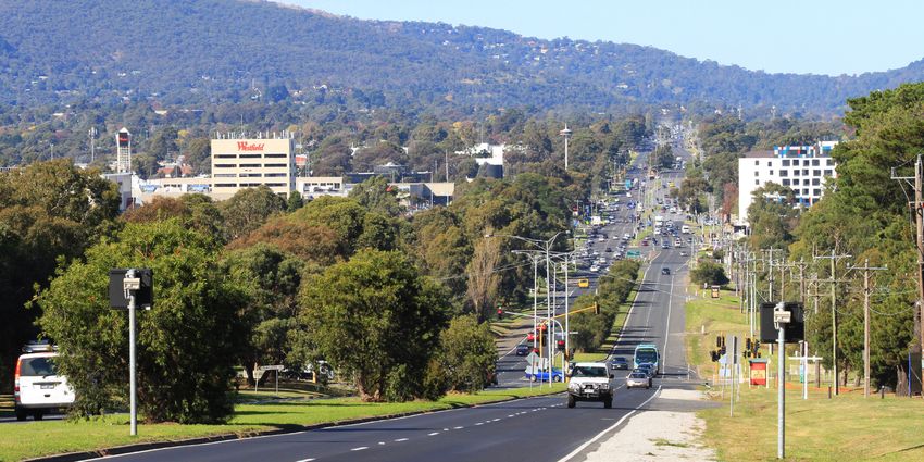
1.1 Background Knox Central is located approximately 35 kilometres east of the Melbourne CBD and covers
Cardno Victoria Pty Ltd (Cardno) has been engaged by Knox City Council to complete an an area of approximately 200 hectares. The location of the Knox Central Study Area in the
Integrated Transport Study to inform the preparation of the Structure Plan for the Knox context of the wider road network is outlined in Figure 1-1.
Central Activity Centre (Knox Central). Knox Central is the municipality’s largest Activity
Figure 1-1 Knox Central Study Area
May 2016 Cardno Victoria Pty Ltd 1Knox Central Integrated Transport Study – Report Prepared for Knox City Council The purpose of the Knox Central Structure Plan is to contemporise the Knox Central Urban Figure 1-2 Key Study Tasks Design Framework (KCUDF) which was adopted by Council in 2005. At the time, the KCUDF articulated Council’s vision for the precinct as a: “modern mixed-use activity centre, bringing about a shift in the role and form by focusing on the highest quality urban design and the broadest possible range of activities in a physically, economically, socially and culturally cohesive vital place.” Further detail on the KCUDF is provided in section 3.2.5 of this report. The Structure Plan will include recommendations for planning controls and policies to implement land use and development objectives and strategies through an amendment to the Knox Planning Scheme. The Structure Plan will also identify necessary infrastructure improvements within the study area. 1.2 Purpose of the Integrated Transport Study The purpose of the Knox Central Integrated Transport Strategy (ITS) is to identify deficiencies and areas of opportunity in the Knox Central study area in order to develop a framework for the future investment in transport network improvements as development grows and demand increases in the study area. The tasks involved in the development of the ITS are outlined in Figure 1-2. May 2016 Cardno Victoria Pty Ltd 2
Knox Central Integrated Transport Study – Report
Prepared for Knox City Council
This ITS report refers to and builds upon the earlier study background reports prepared Westfield Knox Shopping Centre Development Plan and associated reports, including
during the development of the ITS which are outlined as follows: the Transport Impact Assessment Report (2013) and the Westfield Knox Shopping
Existing Conditions Transport Assessment Report (17 February 2016); Centre Expansion Pedestrian and Cycle Movement Plan (2014); and
Information Review and Gap Analysis Report (17 February 2016); and Other documents as identified throughout this report.
Model Development Paper (17 February 2016).
This report also builds on subsequent transport modelling and analysis to provide an 1.4 Consultation
evidence base upon which a set of improvement measures can be developed. The ITS was undertaken in close consultation with Knox City Council officers. Progress
reports were provided to Council Officers over the duration of the study for their review and
1.3 Referenced Documents comment, and two project workshops were also held with Council officers during the
A number of background documents and studies have been considered in preparing this ITS, development of the ITS report. Council officers also provided Cardno with a considerable
amount of relevant background information and reports to inform this report.
including:
The Transport Integration Act (2010) (TIA);
Plan Melbourne – the current Metropolitan Planning Strategy;
VicRoads’ SmartRoads Road User Hierarchy for Knox City;
Knox Vision: Our City, Our Future (2013-2017);
The Knox City Plan (2013-2017);
The Knox Planning Scheme;
The Knox Integrated Transport Plan (2015 – 2025);
The Knox Liveable Streets Plan (2012-2022);
The Knox City Council Mobility Study (2011);
The Knox Community Safety Plan (2013-2017);
The Knox City Council Engineering Standards;
The Knox Pedestrian Plan (2005);
The Knox Bicycle Plan Review (2008);
The Knox Central Urban Design Framework (2005);
The Knox Central Sustainable Transport Options Report (2008);
The Knox Central: Land Use, Economic and Property Analysis Report (2015);
Knox Central Qualitative Movement Economy Report (2008);
May 2016 Cardno Victoria Pty Ltd 3Knox Central Integrated Transport Study – Report
Prepared for Knox City Council
2 Site Location, Land Use and Planning 2.3 Planning Zones
The existing planning zoning for Knox Central shows a variety of statutory planning zones
2.1 Site Location including commercial zones, public use zones, industrial zones, residential zones and priority
The Knox Central Activity Centre is located approximately 35 kilometres east of the development zones.
Melbourne CBD and has an area of approximately 200 hectares. Further detail and a plan showing the existing land use planning zones is provided in the
The overall study area is irregular in shape and is generally bounded by Scoresby Road to the Existing Conditions Transport Assessment Report.
east, Burwood Highway / Swinburne TAFE / St Andrews College to the south, Stud Road to
the west and Westfield Knox / Lewis Park to the north.
Figure 2-1 shows the site boundary and location with respect to the surrounding road
network.
2.2 Existing Land Use
Knox Central comprises a wide range of land uses that result in a cosmopolitan activity
centre. Notably, Westfield Knox is the key attractor of visitors to the activity centre and
contains a mix of retail and commercial uses. The following key land uses are within Knox
Central, and are also identified in Figure 2-1:
Educational facilities – Swinburne University of Technology, St Andrews Christian
College, Wantirna South Primary School, and Fairhills High School;
Large retail offer – dominated by a Westfield shopping centre (‘Westfield Knox’);
Aged Care – Villa Maria and the Knox Village Retirement Village;
Government uses – site operated by the Department of Environment, Land, Water and
Planning (DELWP);
Industrial/commercial area – primarily comprising warehouse, manufacturing and
servicing operations;
Environmental values and community/recreational assets – Blind Creek corridor, Lewis
Park, shared pathways, sporting ovals, skate park, community garden, and views to
the Dandenong Ranges;
Residential land (low to high density); and
Civic uses – Knox Civic Centre (offices) and Knox City Council operations centre.
Land use surrounding the study area typically comprises low density residential lots.
May 2016 Cardno Victoria Pty Ltd 4Knox Central Integrated Transport Study – Report Prepared for Knox City Council Figure 2-1 Site Location and Existing Land Use May 2016 Cardno Victoria Pty Ltd 5
Knox Central Integrated Transport Study – Report
Prepared for Knox City Council
Provide for the effective integration of transport and land use and facilitate access to
3 Planning Context & Existing Conditions
social and economic opportunities;
3.1 Introduction Facilitate network-wide efficient, coordinated and reliable movements of persons and
goods at all times; and
In developing the ITS, Cardno undertook a detailed existing information review and gap
analysis assessment of the study area. This included relevant policy and other background Be safe and support health and wellbeing.
documentation, site visits, and consultation with Knox City Council officers. In essence the Act aims to ensure all Government Department stakeholders work towards a
The review included key State Government and local Knox City Council policy and other common goal to provide an integrated and sustainable transport system. Departments and
background reports. A more detailed analysis of the findings of the review of these agencies are bound by the Act and are therefore required to have regard to the transport
documents is provided in the Information Review and Gap Analysis Report prepared as part system objectives and decision-making principles when making decisions and exercising
of this study. powers.
A comprehensive site visit coupled with an information review and considerable consultation 3.2.2 Plan Melbourne (2014)
with Council officers identified the current transport network provision and conditions, and
Plan Melbourne is the current Metropolitan Planning Strategy, and was developed by the
also identified current and potential future gaps in the transport network. More detailed
then State Government and adopted in May 2014, and is currently undergoing a ‘refresh’. It
information regarding the existing transport network in the local area is provided in the
is an integrated land use and transport plan aimed at guiding the way the city will grow and
Existing Conditions Transport Assessment Report prepared as part of this study.
change over the next 40 years. It is a strategy to house, employ and connect more people to
The following sections summarise the key findings of these reviews, and refers to these ITS jobs and services closer to where they live. In terms of transport related objectives, Plan
background reports for more information as appropriate. Melbourne indicates that it will “provide an integrated transport system connecting people to
Issues and opportunities that have been identified throughout this review have been jobs and services, and goods to market”.
summarised and shown on plans for each mode of transport in the respective assessment Plan Melbourne aims to provide good-quality neighbourhood travel options to help people
sections in this report. reach a wide range of local services and activities within 20 minutes, supporting social
inclusion and well-being. The concept of a 20-minute neighbourhood as outlined in Plan
3.2 Planning Policy Review Melbourne is illustrated in Figure 3-1.
3.2.1 The Transport Integration Act (2010)
The Transport Integration Act (the Act) came into effect on 1 July 2010, with the purpose of
creating a framework for the provision of an integrated and sustainable transport system in
Victoria. The Act sets out six transport objectives as follows:
Provide a means by which persons can access social and economic opportunities to
support individual and community wellbeing;
Facilitate economic prosperity;
Actively contribute to environmental sustainability;
May 2016 Cardno Victoria Pty Ltd 6You can also read