Adopted by Land Information Council on October 31, 2018 - www.co.wood.wi.us (715) 421-8469
←
→
Page content transcription
If your browser does not render page correctly, please read the page content below
Adopted by Land Information Council on October 31, 2018

                Wood County Land Information Office
        400 Market Street, 2nd Floor | Wisconsin Rapids, WI 54494
                              (715) 421-8469
                            www.co.wood.wi.us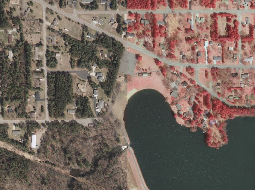
_

CONTENTS
EXECUTIVE SUMMARY ........................................................ 3
1 INTRODUCTION .............................................................. 4
2 FOUNDATIONAL ELEMENTS .......................................... 7
    PLSS .............................................................................................................................. 8
    Parcel Mapping ......................................................................................................... 11
    LiDAR and Other Elevation Data ............................................................................ 14
    Orthoimagery............................................................................................................ 15
    Address Points and Street Centerlines................................................................... 16
    Land Use .................................................................................................................... 18
    Zoning ........................................................................................................................ 19
    Administrative Boundaries ...................................................................................... 20
    Other Layers .............................................................................................................. 22

3 LAND INFORMATION SYSTEM ..................................... 24
    Public Access and Website Information ................................................................ 28

4 CURRENT & FUTURE PROJECTS .................................. 30
    Project Plan to Maintain Searchable Format (Benchmarks 1 & 2) ..................... 31
    Project Plan for PLSS (Benchmark 4) ..................................................................... 32
    Project #1: 2020 Orthophotography Acquisition ................................................. 34
    Project #2: Parcel Fabric Maintenance and Accuracy Improvements ................ 35
    Project #3: Indexing of Non-Recorded Documents by Geography ................... 35
    Project #4: Hydrographic Layer Improvement ..................................................... 36
    Project #5: NG911 .................................................................................................... 36
    Project #6: ROD System Upgrades ......................................................................... 37
    Project #7: GIS Website, Data Hosting Services, Software and Hardware
    Maintenance ............................................................................................................. 38
    Project #8: Research and Mapping Right-of-Ways .............................................. 38
    Project #9: Historical Tax Roll Scanning ................................................................ 39
    Ongoing Costs Not Associated With a Specific Project ....................................... 40

                                                                                                                                            2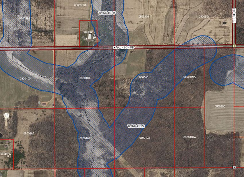
EXECUTIVE SUMMARY
About this Document. This document is a land information plan for Wood County prepared by the
land information officer (LIO) and the Wood County land information council. Under state statute
59.72(3)(b), a “countywide plan for land records modernization” is required for participation in the
Wisconsin Land Information Program (WLIP). The purpose of this document is twofold: 1) to meet WLIP
funding eligibility requirements necessary for receiving grants and retaining fees for land information, and
2) to plan for county land records modernization in order to improve the efficiency of government and
provide improved government services to businesses and county residents.

WLIP Background. The WLIP, administered by the Wisconsin Department of Administration, is
funded by document recording fees collected by register of deeds at the county-level. In 2018, Wood
County was awarded $58,120 in WLIP grants and retained a total of $92,880 in local register of deeds
document recording fees for land information.

This plan lays out how funds from grants and retained fees will be prioritized. However, as county budgets
are determined on an annual basis with county board approval, this plan provides estimated figures that
are subject to change and are designed to serve planning purposes only.

Land Information in Wood County. Land information is central to county operations, as many
essential services rely on accurate and up-to-date geospatial data and land records. A countywide land
information system supports economic development, emergency planning and response, and a host of
other citizen services. The Wood County land information system integrates and enables efficient access
to information that describes the physical characteristics of land, as well as the property boundaries and
rights attributable to landowners.

Mission of the Land Information Office. Eliminate or reduce redundancy through the
coordination and modernization of existing services provided by and between departments and agencies
participating in the program; Develop an efficient delivery system for products and services offered to the
public, and; Improve the quality of products and services offered to the public.

Land Information Office Projects. To realize this mission, in the next three years, the county land
information office will focus on the following projects:

        Wood County Land Information Projects: 2019-2021
        Project #1   PLSS Monumentation
        Project #2   2020 Orthophotography
        Project #3   Register of Deeds System Upgrades
        Project #4   Document Imaging
        Project #5   Hydrographic Layer Improvement
        Project #6   NG911

The remainder of this document provides more details on Wood County and the WLIP, summarizes
current and future land information projects, and reviews the county’s status in completion and
maintenance of the map data layers known as Foundational Elements.

                                                                                                               3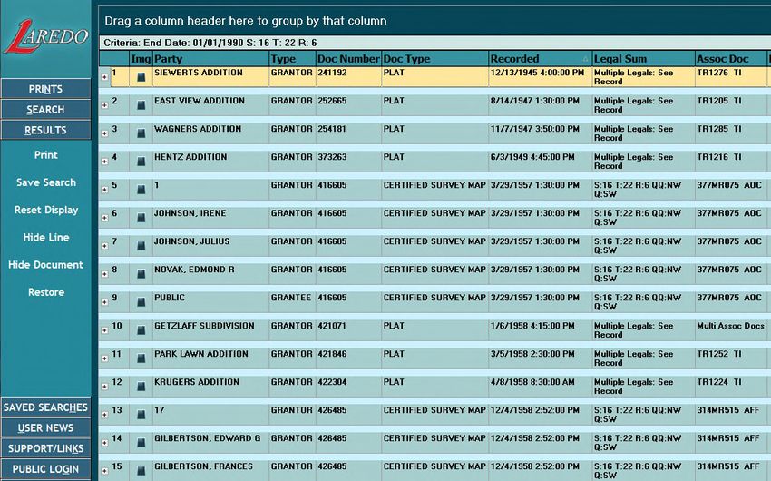
1 INTRODUCTION
In 1989, a public funding mechanism was created whereby a
portion of county register of deeds document recording fees
collected from real estate transactions would be devoted to land
Any physical, legal, economic or
information through a new program called the Wisconsin Land environmental information or
Information Program (WLIP). The purpose of the land information characteristics concerning land,
plan is to meet WLIP requirements and aid in county planning for water, groundwater, subsurface
land records modernization. resources or air in this state.
The WLIP and the Land Information Plan ‘Land information’ includes
information relating to
Requirement topography, soil, soil erosion,
In order to participate in the WLIP, counties must meet certain geology, minerals, vegetation,
requirements: land cover, wildlife, associated
Update the county’s land information plan at least every natural resources, land
three years ownership, land use, land use
Meet with the county land information council to review controls and restrictions,
jurisdictional boundaries, tax
expenditures, policies, and priorities of the land
assessment, land value, land
information office at least once per year survey records and references,
Report on expenditure activities each year geodetic control networks, aerial
Submit detailed applications for WLIP grants photographs, maps, planimetric
Complete the annual WLIP survey data, remote sensing data,
Subscribe to DOA’s land information listserv historic and prehistoric sites and
Coordinate the sharing of parcel/tax roll data with the economic projections.
Department of Administration in a searchable format – Wis. Stats. section 59.72(1)(a)
determined by DOA under s. 59.72(2)(a)
Any grants received and fees retained for land information through the WLIP must be spent consistent
with the county land information plan.
Act 20 and the Statewide Parcel Map Initiative
A major development for the WLIP occurred in 2013 through the state budget bill, known as Act 20. It
directed the Department of Administration (DOA) to create a statewide digital parcel map in coordination
with counties.
Act 20 also provided more revenue for WLIP grants, specifically for the improvement of local parcel
datasets. The WLIP is dedicated to helping counties meet the goals of Act 20 and has made funding
available to counties in the form of Strategic Initiative grants to be prioritized for the purposes of
parcel/tax roll dataset improvement.
For Strategic Initiative grant eligibility, counties are required to apply WLIP funding toward achieving
certain statewide objectives, specified in the form of “benchmarks.” Benchmarks for parcel data—
standards or achievement levels on data quality or completeness—were determined through a
participatory planning process. Current benchmarks are detailed in the WLIP grant application, as will be
future benchmarks.
WLIP Benchmarks (For 2016-2018 Grant Years)
Benchmark 1 & 2 – Parcel and Zoning Data Submission/Extended Parcel Attribute Set Submission
Benchmark 3 – Completion of County Parcel Fabric
Benchmark 4 – Completion and Integration of PLSS
4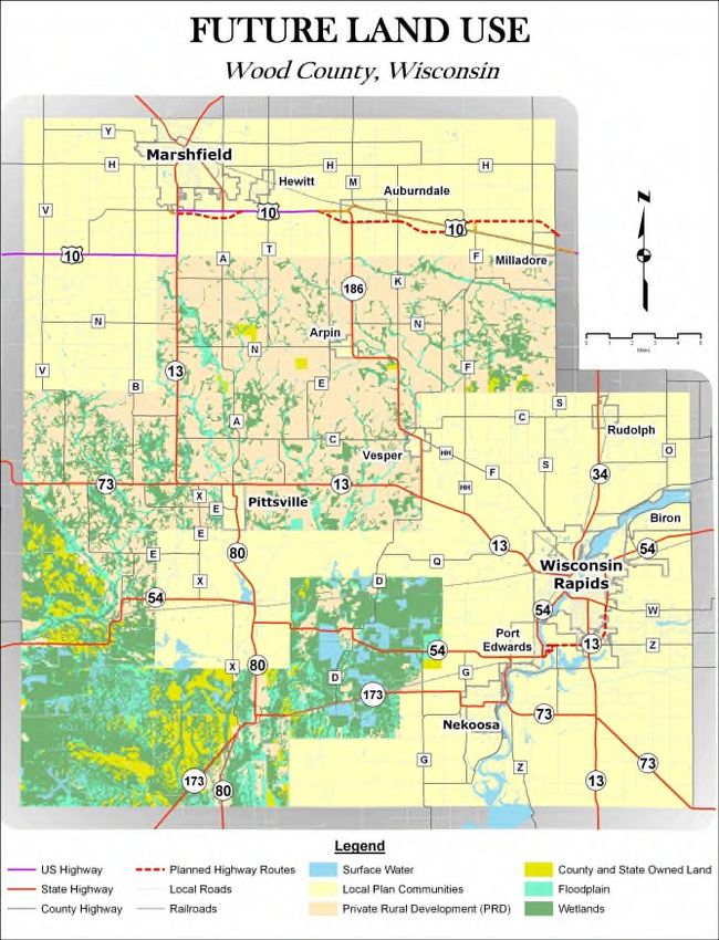
More information on how Wood County is meeting these benchmarks appears in the Foundational
Elements section of this plan document.
County Land Information System History and Context
The Wood County Land Information Office (WCLIO) was officially formed through County Board
resolution #90-8-8 on August 21, 1990. The WCLIO was originally set up under the jurisdiction of the
General Claims Committee, with the Wood County Register of Deeds named as the contact person.
However with the passage of Resolution #92-6-8 on June 16, 1992, the WCLIO was moved to the Wood
County Planning and Zoning Office with the Planning and Zoning Committee as the oversight committee.
WCLIO has retained this structure ever since.
The first 15 years of the Land Records Modernization Program (1991 – 2006) focused on establishing the
foundation on which much of the program’s future would be built off of. During this time the County
purchased Geographic Information System (GIS) software, established the staff positions of the Land
Information Officer, and the Geographic Information System Specialist, and began developing
foundational GIS data layers. In the early years of land records modernization much of the focus was on
project prioritization, needs assessments and data creation. The end of this period had many quantifiable
achievements that involved significant advances in the County Geographic Information System. Of
particular note was 2005, which saw the “completion” of digital parcel mapping, the first digital aerial
photography acquisition and the ArcIMS Interactive GIS Map and Property Tax Data application launched.
Since 2005, much of the focus in land records modernization has been on maintaining and improving the
quality of GIS information, acquiring new data (e.g. LiDAR), implementing digital imaging projects, and
integrating/linking records from departments and agencies, and developing ways to improve public
access to records through web applications.
From the inception of the Land Records Modernization Program, the goals have remained relatively the
same; however the objectives have continually been updated as a means to achieve the goals. The
objectives have changed from a focus on technical issues and data creation in the early years of the
program; to maintaining, sharing, publishing, and utilizing data for decision making in recent years.
County Land Information Plan Process
County land information plans were initially updated every five years. However, as a result of Act 20,
counties must update and submit their plans to DOA for approval every three years. The 2019-2021 plan,
completed at the end of 2018, is the second post-Act 20 required update.
Plan Participants and Contact Information
Another requirement for participation in the WLIP is the county land information council, established by
legislation in 2010. The council is tasked with reviewing the priorities, needs, policies, and expenditures of
a land information office and advising the county on matters affecting that office.
According to s. 59.72(3m), Wis. Stats., the county land information council is to include:
Register of Deeds
Treasurer
Real Property Lister or designee
Member of the county board
Representative of the land information office
A realtor or member of the Realtors Association employed within the county
A public safety or emergency communications representative employed within the county
County surveyor or a registered professional land surveyor employed within the county
Other members of the board or public that the board designates
5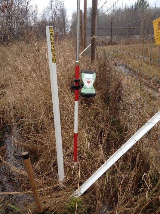
The land information council must have a role in the development of the county land information plan,
and DOA requires county land information councils to approve final plans.

This plan was prepared by the county LIO, the Wood County Land Information Council, and others as
listed below.

Wood County Land Information Council
Name                   Title                      Affiliation                Email                        Phone
* Justin Conner        Land Records Coordinator   Wood County Planning and   jconner@co.wood.wi.us        715-421-8469
                                                  Zoning
* Kevin Boyer          County Surveyor            Wood County Surveyor       kboyer@co.wood.wi.us         715-421-8528

* Nanci Marti          Real Property Lister       Wood County Treasurer’s    nmarti@co.wood.wi.us         715-421-8479
                                                  Office
* Kenneth A Curry      County Board Member        Wood County Board          wcdistrict11@co.wood.wi.us   715-459-3392

* Tiffany Ringer       Register of Deeds          Wood County Register of    tringer@co.wood.wi.us        715-421-8455
                                                  Deeds Office
* Brian Spranger       Realtor                    First Weber                sprangerb@firstweber.com     715-572-7117

* Lori Heideman        Dispatch Manager           Wood County Dispatch Center lheideman@co.wood.wi.us     715-421-8668

* Heather Gehrt        Treasurer                  Wood County Treasurer’s    hgehrt@co.wood.wi.us         715-421-8482
                                                  Office
* Allen Breu           Town of Marshfield Chair   Town of Marshfield         breutown@frontier.com        715-387-4222

                                                                                                                         6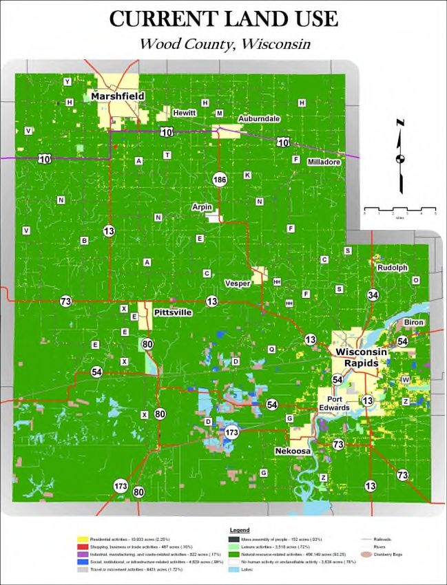
2 FOUNDATIONAL ELEMENTS
Counties must have a land information plan that
addresses development of specific datasets or map layer
groupings historically referred to as the WLIP
Foundational Elements. Foundational Elements                PLSS
incorporate nationally-recognized “Framework Data”          Parcel Mapping
                                                            LiDAR and Other Elevation Data
elements, the major map data themes that serve as the
                                                            Orthoimagery
backbone required to conduct most mapping and               Address Points and Street Centerlines
geospatial analysis.                                        Land Use
                                                            Zoning
In the past, Foundational Elements were selected by the     Administrative Boundaries
former Wisconsin Land Information Board under the           Other Layers
guiding idea that program success is dependent upon a
focus for program activities. Thus, this plan places priority
on certain elements, which must be addressed in order for a county land information plan to be approved.
Beyond the county’s use for planning purposes, Foundational Element information is of value to state
agencies and the WLIP to understand progress in completion and maintenance of these key map data
layers.

                                                                                                           7
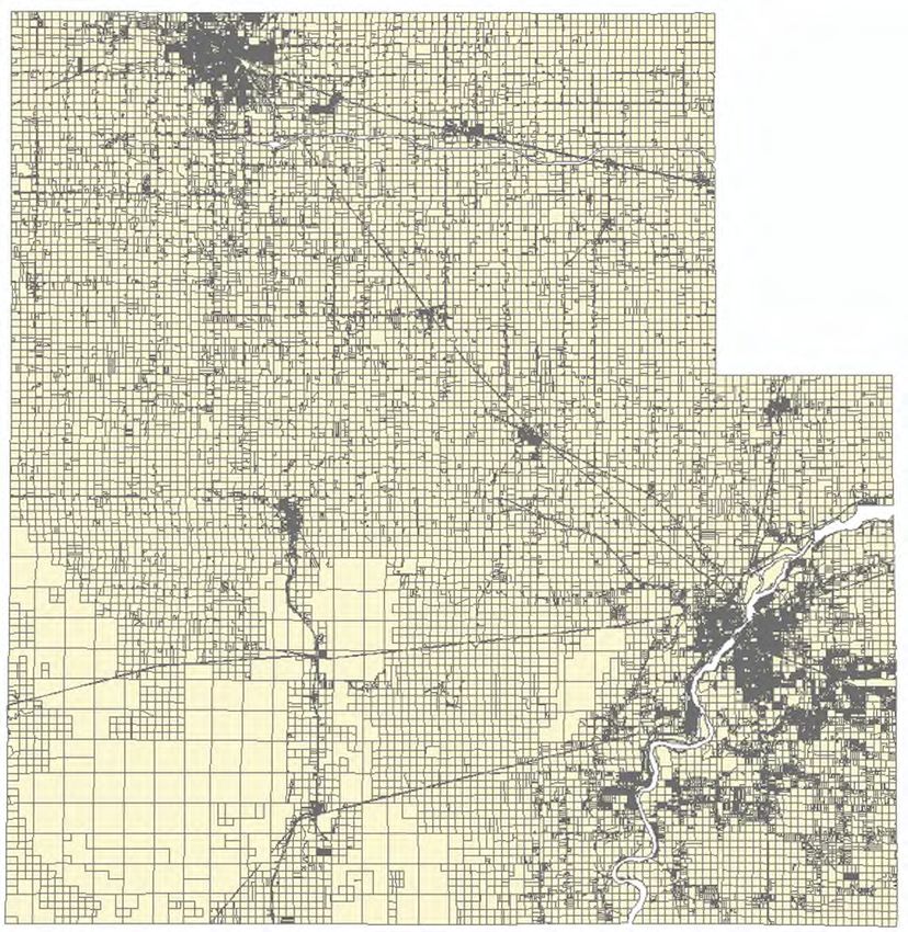
PLSS
Public Land Survey System Monuments
Layer Status
PLSS Layer Status
Status/Comments
Number of PLSS corners (selection, ¼, meander) set in 2,615
original government survey that can be remonumented in
your county
Number and percent of PLSS corners capable of being 2,615 (100%)
remonumented in your county that have been
remonumented
Number and percent of remonumented PLSS corners with 2,615 (100%)
survey grade coordinates (see below for definition)
SURVEY GRADE – coordinates collected under the
direction of a Professional Land Surveyor, in a
coordinate system allowed by 236.18(2), and obtained
by means, methods and equipment capable of
repeatable 2 centimeter or better precision
SUB-METER – point precision of 1 meter or better
APPROXIMATE – point precision within 5 meters or
coordinates derived from public records or other
relevant information
Number and percent of survey grade PLSS corners 2,615 (100%)
integrated into county digital parcel layer
Number and percent of non-survey grade PLSS corners 0
integrated into county digital parcel layer
Tie sheets available online? Yes http://opendata.woodcogis.com/pages/survey-records
Percentage of remonumented PLSS corners that have tie 100%
sheets available online (whether or not they have
corresponding coordinate values)
Percentage of remonumented PLSS corners that have tie 100%
sheets available online (whether or not they have
corresponding coordinate values) and a corresponding
URL path/hyperlink value in the PLSS geodatabase
PLSS corners believed to be remonumented based on filed 0
tie-sheets or surveys, but do not have coordinate values
Approximate number of PLSS corners believed to be lost or 0
obliterated
Which system(s) for corner point identification/ Romportl point numbering system known as Wisconsin
numbering does the county employ (e.g., the Romportl Corner Point Identification System
point numbering system known as Wisconsin Corner Point
Identification System, the BLM Point ID Standard, or other
corner point ID system)?
Does the county contain any non-PLSS areas (e.g., river No
frontage long lots, French land claims, private claims, farm
lots, French long lots, etc.) or any special situations
regarding PLSS data for tribal lands?
Total number of PLSS corners along each bordering county 241
Number and percent of PLSS corners remonumented along 241 (100%)
each county boundary
Number and percent of remonumented PLSS corners along 241 (100%)
each county boundary with survey grade coordinates
In what ways does your county collaborate with or plan to Yes, The Wood County Surveyor notifies surrounding counties
collaborate with neighboring counties for PLSS updates on with updated tie sheets and coordinates. These are accessible
shared county borders? to the surveying community at the following link:
http://opendata.woodcogis.com/
Custodian
County Surveyor in conjunction with the Land Information Office
Maintenance
Ongoing maintenance of the PLSS will be accomplished through a planned, long-term
program with the goal of occupying each corner every 10 to 15 years, depending on location,
condition, and other significant factors(e.g. road construction).
8
Standards
Statutory Standards for PLSS Corner Remonumentation
s. 59.74, Wis. Stats. Perpetuation of section corners, landmarks.
s. 60.84, Wis. Stats. Monuments.
ch. A-E 7.08, Wis. Admin. Code, U.S. public land survey monument record.
ch. A-E 7.06, Wis. Admin. Code, Measurements.
s. 236.15, Wis. Stats. Surveying requirement.
SURVEY GRADE standard from Wisconsin County Surveyor’s Association:
SURVEY GRADE – coordinates collected under the direction of a Professional Land
Surveyor, in a coordinate system allowed by 236.18(2), and obtained by means,
methods and equipment capable of repeatable 2 centimeter or better precision
Survey Grade PLSS Corners
9
Other Geodetic Control and Control Networks
High Accuracy Reference Network (HARN)
Layer Status
Wood County completed a densification from stations within the Wisconsin High Accuracy
Reference Network (HARN) in 1995 with the assistance of a WLIP grant. In total, 104
monuments are included in this network: 12 - 16" dia. x 5' deep concrete monuments built to
DOT specifications; 5 NGS monuments that were already in existence; 75 - 6" dia. x 7' deep
concrete and steel monuments designed by our local surveyors; and 12 section corner
monuments, all of which are Harrison or Waupaca Foundry cast iron.
Custodian
County Surveyor in conjunction with the Land Information Office
Maintenance
None
Standards
The Wood County geodetic network was developed with three levels of accuracy, and
complies with the WLIB Specifications and Guidelines to Support Densification of the
Wisconsin High Accuracy Reference Network (HARN) Using Global Positioning System (GPS)
Technology - June, 1995.
Geodetic Control Network
10Parcel Mapping
Parcel Geometries
Layer Status
Layer Status
Status/Comments
Progress toward completion/maintenance phase In Wood County, 100% of the county’s parcels are available in a commonly-used digital
GIS format.
Coordinate System / Authority / WKID NAD_1983_HARN_WISCRS_Wood_County_Feet
ESRI
103471
Projection /Datum / Spheroid Lambert Conformal Conic
D_North_American_1983_HARN
GRS_1980
Integration of tax data with parcel polygons Tax and assessment attributes are maintained by the Real Property Lister
(RPL). The parcel geometry is joined to the County tax database using a parcel
identification number (PIN).
Esri Parcel Fabric/LGIM Data Model The county has used the ESRI Parcel Fabric Data Model since 2016
Online Parcel Viewer Software/App ESRI Web AppBuilder for ArcGIS (custom) – In-house
Unique URL path for each parcel record Tax System:
https://propertytax.co.wood.wi.us/gcswebportal/Search.aspx?parcelnumber=
Map: http://gis.co.wood.wi.us/Land-Records-Viewer/index.html?find=
Custodian
Land Records Coordinator and Real Property Lister
Maintenance
Parcel mapping is a top priority. Parcel geometry and attributes are edited as soon as possible
after recording of the source documents. The database is archived on an annual basis.
Standards
The only attribute in the parcel geometry maintained by Wood County is a parcel identification
number (PIN) that links up to the County tax database. All parcels have a PIN, but the parcel
cannot be located on the Public Land Survey System because the PIN is not structured as a
geo-locator.
Parcel Geometries
11Assessment/Tax Roll Data
Layer Status
Layer Status
Status/Comments
Progress toward completion/maintenance phase NA
Tax Roll Software Vendor Name GCS Land Records Management Software
Municipal Notes NA
Custodian
County Treasurer and Real Property Lister
Maintenance
Maintenance of the Searchable Format standard: To maintain the Searchable Format
standard, the county will continue to support the export scripts needed to format tax roll
attributes to the searchable format in a way that they can be joined to parcel polygons.
Searchable Format Workflow: The county maintains parcel/tax roll data in the Searchable
Format or close enough to the Searchable Format that little to no human labor is required for
the annual submission of parcel/tax roll data to DOA.
Standards
s. 73.03(2a), Wis. Stats. Department of Revenue (DOR) – Powers and duties defined. Department
of Revenue Property Assessment Manual – Chapter 5 and DOR format standard requested by
DOR for assessment/tax roll data
s. 59.72(2)(a), Wis. Stats. Presence of all nine “Act 20” attributes
s. 59.72(2)(a), Wis. Stats. Crosswalk of attributes
Public Web Portal to
Search Tax and
Assessment Data
12ROD Real Estate Document Indexing and Imaging
Layer Status
Layer Status
Status/Comments
Grantor/Grantee Index In process of back indexing. Deeds and miscellaneous recorded are indexed to
approximately 1930. Mortgages are back indexed to approximately 1976. All this relates
to our computer system, i.e., iDoc via Fidlar Technologies. We have paper
grantor/grantee indexes from the beginning (1856).
Tract Index PLSS based – Computer tract goes back to August 1, 1999. Paper tract available from
beginning 1856. Tract books are scanned into the computer system.
Imaging Not imaged are lis pendens, corporate records as well as 30+ year old mortgages.
ROD Software/App and Vendor Name Fidlar Laredo/Tapestry
Custodian
County Register of Deeds
Maintenance
New documents are recorded, scanned and indexed daily.
Standards
s. 59.43, Wis. Stats. Register of deeds; duties, fees, deputies.
ch. 706, Wis. Stats. Conveyances of real property; Recording; Titles.
Laredo Document Search
13LiDAR and Other Elevation Data
LiDAR
Layer Status
Layer Status
Status/Comments
Acquisition date March 2015
Accuracy A comparison of the ground survey versus LiDAR model values indicates a vertical root mean square error (RMSEz) of
0.399 feet. This is well within the FEMA specified vertical accuracy tolerance of 0.61 feet. RMSEz varies depending on
land cover:
RMSEz - Urban: 0.110 US Survey Feet
RMSEz - Low Grass: 0.139 US Survey Feet
RMSEz - Tall Grass: 0.319 US Survey Feet
RMSEz - Low Trees: 0.322 US Survey Feet
RMSEz - Tall Trees: 0.397 US Survey Feet
Ground truth survey results report: http://lidar.woodcogis.com/Metadata/LiDAR%20Ground%20Truth%20Survey.pdf
Nominal pulse spacing 1 meter
Next Planned 2030
Acquisition Year
LiDAR Data Download http://gis.co.wood.wi.us/datadistribution/index.html
Available Layers Generated by Contractor
2 foot contour shapefiles
Bare Earth LAS
Point Cloud LAS
Breaklines
Digital Elevation Model DEM
Digital Terrain Model DTM
Digital Surface Model DSM
Intensity Images
LiDAR Derived Hillshade Relief Map of Lake
Custodian
Wazeecha Dam
Land Records Coordinator
Maintenance
LiDAR data is not actively
maintained or updated.
The next project likely
would not happen until at
least 2030.
Standards
FEMA vertical accuracy
standard
14Orthoimagery
Color Infra-red (IR) Digital Orthoimagery
Layer Status
Layer Status
Status/Comments
Acquisition date March 2015
Resolution 6 inch
Standard ASPRS Class II horizontal accuracy specifications at 1" = 100' map scale. The horizontal accuracy meets or exceeds
2.0 feet RMSE using the National Standards for Spatial Data Accuracy (NSSDA) standards.
Next Planned 2020
Acquisition Year
WROC Confirmed participating in WROC 2020
Data Download http://gis.co.wood.wi.us/datadistribution/index.html
Custodian
Land Records Coordinator
Maintenance
None
2015 6”Orthophotography
LEFT - True Color RIGHT - False Color
Infrared
15Historic Orthoimagery
Layer Status
Wood County, like most other counties has a wide variety of historic aerial imagery dating as
far back as the mid-thirties. The most comprehensive list of historic aerial imagery can be
found on the Wisconsin State Cartographer’s Office (SCO) website. The website allows users
to search any county in Wisconsin for imagery, and submit updates or revisions to the index if
necessary. Most of the historic imagery for Wood County is not in a digital format that is
usable in the GIS. Wood County does not have the original film or images for most of the
historic aerial imagery because the County did not commission the acquisition of the imagery.
The first time that Wood County contracted to have the entire County flown was in 2005. This
18” black and white project was part of a consortium coordinated by the North Central
Wisconsin Regional Planning Commission. Five years later the County acquired 18” color
digital orthophotography through the Wisconsin Regional Orthophotography Consortium
(WROC).
Custodian
Land Records Coordinator
Other Types of Imagery
Satellite Imagery. Wood County has never acquired satellite imagery, but may consider it in
the future. Future consideration of purchasing satellite imagery is dependent on technological
advances and a cost/benefit analysis of purchasing it compared to traditional
orthophotography.
Oblique Aerial Imagery. In recent years there has been a some interest for oblique aerial
imagery in Wood County. Most of the interest has been from law enforcement agencies,
emergency responders, and municipalities. Given the rural nature of Wood County, we don’t
feel there is justification for WLIP investment in oblique aerial imagery.
Address Points and Street Centerlines
Address Point Data
Layer Status
Site Address points exist for all known addressed structures located within the county.
Coordinating the collection of new and changed addresses across the County is a challenge.
Wood County Emergency Management Agency (EMA) manages addresses for most towns,
and some villages. The County works with municipalities that it does not issue addresses for,
to update the site address database that is used for a variety of applications including
emergency dispatch. Municipalities managing their own addresses include the Town of Grand
Rapids, villages of Biron, Rudolph, Milladore, and Port Edwards along with the cities of
Wisconsin Rapids, Marshfield and Pittsville.
Address points are mapped to the driveway and then adjusted to the structure after each
round of aerial photography.
Custodian
Wood County Emergency Management Agency
Land Records Coordinator
Municipal addressing authorities
Maintenance
Site address points are mapped when notified of changes or new addresses.
Standards
Meet the requirements of e911 dispatch
16Street Centerlines
Layer Status
All public and private street and highway
centerlines are mapped for the County.
Centerline data is fully populated with
address ranges, street name, municipality,
zip codes, etc. to support e911 geocoding.
The centerlines are used to create street
maps and other base maps, and are an
integral component of the emergency
response system
Custodian
Land Records Coordinator
Maintenance
Data is updated as new information is made
available
Standards
Meet the requirements of e911 dispatch.
Street Centerlines
Rights of Way
Layer Status
Approximate right-of-way is available for all townships and villages in Wood County. A
comprehensive determination of right-of-way ownership and transfers has not been
completed.
Custodian
Land Records Coordinator
Maintenance
Update as needed to reflect surveys, transportation plats and deeds.
Standards
None
Trails Snowmobile trails are mapped with GPS.
e.g., Recreational Trails
Layer Status
Recreation trail routes are maintained in the County
parks as well as bicycle and pedestrian trails throughout
the County. Snowmobile trails for the entire County are
mapped, and ATV trails on County property are
mapped.
Custodian
Land Records Coordinator
Maintenance
As needed
Standards
None
17Land Use
Current Land Use
Layer Status
Land use maps are available for all townships
in Wood County and created using the Land-
Based Classification Standards. Land use
mapping for cities and villages will be
completed in the future on an as-need basis.
Land use codes that are used in the tax parcel
database are compliant with the Department
of Revenue Land Use Classification System.
Custodian
Wood County Planning and Zoning
Maintenance
Land use maps are updated as projects require
and based of the most recent imagery
available at that time. Most townships have
not been remapped since the creation of the
layer over 10 years ago.
Standards
American Planning Association Land Based
Classification Standards (LBCS)
Future Land Use
Layer Status
Future land use was created as a product of
the Wood County Comprehensive Plan that
was completed in 2010. Future land use is
based off of wetlands, floodplains, and
water bodies that limit or prohibit future
development.
Custodian
Wood County Planning and Zoning
Maintenance
Future land use maps would be updated
along subsequent comprehensive plans
Standards
s. 66.1001, Wis. Stats. Comprehensive
planning.
18Zoning
County General Zoning
Layer Status
Not administered by county.
Shoreland Zoning
Layer Status
The County does maintain a GIS representation of county shoreland zoning boundaries.
Shoreland areas were determined by buffering the hydrography layer as defined by the
County Shoreland Zoning Ordinance. This layer is only a graphical representation and NOT an
official boundary deleneation.
Custodian
Planning and Zoning
Land Records Coordinator
Maintenance
Shoreland zoning buffers will be updated as hydrography layers are improved.
Standards
Wood County Shoreland Zoning Ordinance
Farmland Preservation Zoning
Layer Status
Not administered by county.
Shoreland Zoning Buffer
19Floodplain Zoning
Layer Status
The County does maintain a GIS representation of floodplain zoning boundaries.
The county’s floodplain zoning GIS data is identical to the FEMA map.
In 2010, Federal Emergency Management Agency (FEMA) initiated a floodplain mapping
update. Although the mapping used the best available information, accurate LiDAR elevation
data is now available and should be used to accurately delineate floodplains.
Custodian
Federal Emergency Management Agency
Land Records Coordinator
Maintenance
None currently. However, FEMA Flood Hazard maps should be updated using LiDAR to
accurately delineate floodplains.
Standards
** Standards set by Federal Emergency Management Agency
Airport Protection
Layer Status
Not administered by county.
Administrative Boundaries
Civil Division Boundaries
e.g., Towns, City, Villages, etc.
Layer Status
The civil boundaries within Wood County were constructed using our parcel data, PLSS data
and annexation documents.
Custodian
Land Records Coordinator
Maintenance
As needed to reflect annexations.
Standards
Meets the data requirements for Consolidated Boundary Annexation Survey (CBAS)
School Districts
Layer Status
School district codes are maintained for every parcel in the tax database. We join the tax data
to the parcel layer to generate school district boundary maps.
Custodian
Real Property Lister
Land Records Coordinator
Maintenance
As needed
Standards
Meets the data requirements for Consolidated Boundary Annexation Survey (CBAS)
20Election Boundaries
e.g., Voting Districts, Precincts, Wards, Polling Places, etc.
Layer Status
The County created municipal ward and county supervisory districts, along with voting district
maps during the 2010 redistricting.
Custodian
County Clerk
Land Records Coordinator
Maintenance
Maintenance typically occurs during annexations and the decennial redistricting process.
Standards
Meets the data requirements for Consolidated Boundary Annexation Survey (CBAS)
Public Safety
e.g., Fire/Police Districts, Emergency Service Districts, 911 Call Center Service Areas, Public
Safety Answering Points, Healthcare Facilities
Layer Status
Emergency service districts are mapped and referenced in the County Shared Dispatch Center
to dispatch the appropriate emergency responders. Wood County Shared Dispatch Center is
designated as the County PSAP. The Shared Dispatch Center is located in Wisconsin Rapids in
the Wood County Courthouse.
Custodian
Land Records Coordinator
Dispatch Manager
Maintenance
Update as needed
Standards
Meets the data requirements to supprt e911 dispatching
Native American Lands
Layer Status
All Native American lands are included in the County parcel mapping and can be queried and
mapped on request.
Custodian
Land Records Coordinator
Real Property Lister
Maintenance
Maintained within parcel layer.
Standards
See parcel mapping
21Other Layers
Hydrography Maintained by County or Value-Added
e.g., Hydrography maintained separately from DNR or value-added, such as adjusted to orthos
Layer Status
The hydrography of the County is mapped and was created based off of data from the
Wisconsin Department of Natural Resources. The data has improved as our aerial photography
improves.
Custodian
Land Records Coordinator
Maintenance
Data is edited against aerial photography and LiDAR layers as time allows.
Standards
None
Hydrography
Cell Phone Towers
Cell Phone Towers
Layer Status
Cell phone towers are mapped to support e911 dispatch
Custodian
Land Records Coordinator
Maintenance
Updated as needed
Standards
Meets the data requirements for e911 dispatch.
22Public Lands
Layer Status
Wood County offers 7 recreational parks, 38,000 acres of county forest land, and 18,500 acres
of Wood County State Wildlife Area. All public lands are included in the County parcel
mapping database. Additionaly, public land amenities such as beaches, camprgounds, boat
access, etc. are mapped to support map creation.
Custodian
Park and Forestry Department
Land Records Coordinator
Maintenance
Updates as needed.
Standards
None
Public Lands
233 LAND INFORMATION SYSTEM
The WLIP seeks to enable land information systems that are both modernized and integrated. Integration
entails the coordination of land records to ensure that land information can be shared, distributed, and
used within and between government at all levels, the private sector, and citizens.
One integration requirement is listed under s. 16.967(7)(a)(1), Wis. Stats., which states that counties may
apply for grants for:
The design, development, and implementation of a land information system that contains and
integrates, at a minimum, property and ownership records with boundary information,
including a parcel identifier referenced to the U.S. public land survey; tax and assessment
information; soil surveys, if available; wetlands identified by the department of natural
resources; a modern geodetic reference system; current zoning restrictions; and restrictive
covenants.
This chapter describes the design of the county land information system, with focus on how data related
to land features and data describing land rights are integrated and made publicly available.
24County Parcel Data Workflow Diagram
This diagram documents Wood County’s parcel mapping and tax roll process.
Register of Deeds Municipal Assessors State
Records real estate docs Update property values DOR – Equalized assessment values,
Property tax credits
Sends real estate transfer returns to
the State DNR – Managed Forest Lands Values
Creates grantor/grantee and tract
indices in Fidlar Technologies iDOC
software
Surveyor/ Land Information Real Property Lister
Officer
Manages parcel attributes in GCS tax database
PLSS Monumentation Assigns unique parcel ID
Land Information Officer
Edit parcel geometries in ESRI Parcel
Fabric
Extract parcel geometry Treasurer’s Office
Transform tax roll to Act 20 attribute Finalize Tax Roll
schema Tax deeds
Load Act 20 attributes to parcel Print and mail property tax bills
geometry
Submits parcel polygons with
tax roll data to DOA
DOA Tax
Assembles Bills
Statewide Parcel Layer from
Data
25Technology Architecture and Database Design
This section refers to the hardware, software, and systems that the county uses to develop and operate
computer systems and communication networks for the transmission of land information data.
The Wood County Land Information System runs on the County’s local area network and is supported by
the Information Systems (IS) Department. The IS Department is committed to supporting all activities of
the Land Records Modernization Program and has been a reliable contributor to system development and
support.
Wood County Land Information uses one Windows Server 2008 R2 virtual machine (DB-GIS), Amazon
Web Services and ArcGIS Online. DB-GIS is the GIS file and web server. DB-GIS runs ArcGIS Server
Standard Workgroup to support data editing and publishing web services. Amazon Web Services and
ArcGIS Online are employed to decrease the demand on DB-GIS, data backups, and document storage.
Wood County Land Information System
Generalized Network Architecture
Website Development/Hosting
All website development and hosting is done in-house, ArcGIS Online or Amazon Web
Services (AWS)
A combination of ESRI Web AppBuilder and ArcGIS Online configurable apps are used for web
maps.
26Metadata and Data Dictionary Practices
Metadata is maintained for many of the County’s GIS layers. It is not 100% complete at this time, but
metadata improvement is an ongoing initiative that will strive for near complete coverage of all Wood
County GIS layers. Data sets that are created for a specific use for a limited period of time and for an
identified user may not be subject to metadata requirements of shared GIS baselayers. ArcCatalog is used
to develop and provide access to geospatial metadata consistent with the FGDC Content Standard for
Digital Geospatial Metadata
Municipal Data Integration Process
The cities of Marshfield and Wisconsin Rapids are the only two with in-house GIS staff. Of those two, only
Marshfield edits their own parcel data in GIS. Marshfield shares parcels, addresses, roads, etc to
incorporate in countywide datasets. Wisconsin Rapids accesses county parcel and other base layers
through an ArcGIS Server geodata service. The geodata service is used to periodically synchronize the
geodatabase over the Internet.
In the past, the Land Information Office has provided data to any contractors that are working on projects
for municipalities. In fact, some contractors even incorporate county web services via REST it into
municipal projects
27Public Access and Website Information
Public Access and Website Information (URLs)
Single Landing Page/Portal for All Land Records Data
URL
http://www.co.wood.wi.us/Departments/PZ/LandRecords.aspx
Public Access and Website Information
GIS Webmapping Application(s)
Link - URL GIS Download Link - URL Real Property Lister Link - URL Register of Deeds Link - URL
http://gis.co.wood.wi.us http://opendata.woodcogis.com/ https://propertytax.co.wood.wi.us/gc https://www.co.wood.wi.us/Departm
swebportal/Search.aspx ents/ROD/LandRecords.aspx
Municipal Website Information
Municipal Website Municipal Website URL
City of Wisconsin Rapids http://gis.wirapids.org/
City of Marshfield http://comgis.ci.marshfield.wi.us/MPV/
28Data Sharing
Data Availability to Public
Wood County makes land records information available according to the requirements of the Wisconsin
Open Records Law. The public has FREE, both in terms of cost and barriers, access to land records
through the County Interactive Web Map, the Land Records Portal and the upcoming Open Data Portal.
Even “expensive” data like orthophotography and LiDAR will be available for FREE.
Data Sharing Restrictions and Government-to-Government Data Sharing
Data Sharing Restrictions
Wood County imposes no use restrictions. Users are free to share and adapt the data for any
purpose, even commercially. We do ask that users give appropriate attribution of our source
data.
Government-to-Government Data Sharing
Data-sharing is encouraged because of the resulting cost savings and efficiencies. The County
has used both formal and informal agreements to share data when necessary. Wood County
does not require agreements for Government-to-Government data sharing.
Training and Education
The Land Information Office has offered GIS training sessions that were open to other
governmental agencies and the general public. We support training opportunities offered by the
Wisconsin Land Information Association (WLIA) and ESRI Wisconsin User Group (EWUG) because
they are effective ways of providing information on timely topics at a reasonable price.
All County staff have internet access to online training or coursework, and participation in training
sessions is encouraged. On occasion, educational sessions and demonstrations are presented to
staff, elected officials and the general public.
WLIP Education and training funds are used to supplement the cost of sending staff to training at
conferences and workshops.
294 CURRENT & FUTURE PROJECTS
This chapter lists the current and future land information projects the county is currently undertaking or
intends to pursue over its planning horizon. A project is defined as a temporary effort that is carefully
planned to achieve a particular aim. Projects can be thought of as the means to achieving the county’s
mission for its land information system.
County Land
Information PLAN
Plan
PROJECTS!
2019
2019-2021 Land Info Plan 2020
due at end of 2018
2022-2024 Land Info Plan 2021
due at end of 2021
APPLY FOR WLIP Parcel/
FUNDING Grant Tax Roll
FOR PROJECTS Application Submittal
(FOR NEXT
CALENDAR YEAR)
to DOA
Due Due
December 31st March 31st
REPORT Retained
ON Fee/
PROJECTS Grant
(FROM PREVIOUS
CALENDAR YEAR)
Report
Due
June 30th
Figure 1. The WLIP Land Information Plan/Grant Project Cycle 30Project Plan to Maintain Searchable Format (Benchmarks 1 & 2)
Project Title: Project Plan to Maintain Searchable Format (Benchmarks
1 & 2)
Project Description/Goal
How Searchable Format Will Be Maintained
Wood County will continue to support the export scripts needed to format tax roll attributes to the
searchable format in a way that they can be joined to parcel polygons.
Business Drivers
The Project Plan to Maintain Searchable Format for Benchmarks 1 & 2 is a requirement for those
counties who utilize Strategic Initiative funds for parcel/tax roll formatting to prepare the data
submission to DOA.
Objectives/Measure of Success
The objective is to continue to meet the Searchable Format for Benchmarks 1 & 2 (Parcel and
Zoning Data Submission, Extended Parcel Attribute Set Submission).
Project Timeframes
Timeline – Project Plan to Maintain Searchable Format
Milestone Duration Date
Submit data to DOA – Annually by March 31st
Responsible Parties
Wood County - Join tax information to parcel geometry, compile zoning data and submit to DOA.
Estimated Budget Information
Annual costs would be minimal barring any changes to the Searchable Format, software, and tax
database.
$3000 - Land Records Coordinator
31Project Plan for PLSS (Benchmark 4)
Project Title: Project Plan for PLSS (Benchmark 4)
Project Description/Goal
Planned Approach
In 2010, Wood County began a renewed push to fulfill the goal of 100% PLSS remonumentation
with survey grade coordinates. That goal was met by the end of 2018. Ongoing maintenance of
the PLSS will be accomplished through a planned, long-term program.
Wood County has a “bounty program” in place where surveyors are paid a set fee for maintenance
of corners that have been disturbed and are important to land surveys that they are completing.
Preapproval for each corner covered under this program is necessary.
The County works with towns to maintain corners that fall in the right-of way of County highways
and local road projects. Towns are encouraged to contact the County Surveyor prior to
commencement of any local road improvements that could affect PLSS corners. The County
annually contracts with a registered land surveyor to maintain the corners that will be impacted by
County highway and local road projects.
Current Status
Tally of the total number of corners: 2615
Remonumentation status: 2615
Coordinate status (accuracy class) if known: Survey Grade
Goals
The goal of the PLSS maintenance program is to visit each corner every 10 to 15 years, depending
on location, condition, and other significant factors(e.g. road construction).
Number of corners to be remonumented during plan period: ~600
Number to have new coordinates established during plan period: ~600
Accuracy class for these new coordinates: Survey Grade
Way in which these points will be integrated into the parcel fabric: New points are imported
into the Parcel Fabric and used to map new surveys and land divisions.
Missing Corner Notes
Documentation for any missing corner data: None.
County Boundary Collaboration
The Wood County Surveyor notifies surrounding counties with updated tie sheets and coordinates.
These are accessible to the surveying community at the following link:
http://opendata.woodcogis.com/
Business Drivers
The Project Plan for PLSS is a requirement for those counties who utilize Strategic Initiative funds
for work related to PLSS completion and integration.
Wood County has invested considerable resources, especially in the last 8 years.
Continuous maintenance is needed to protect our investment.
PLSS monuments are the fundamental building blocks for land descriptions and property
ownership.
Surveyors, engineers, realtors and other professionals rely on accurate land information.
Parcel mapping improvements
Objectives/Measure of Success
100% PLSS remonumentation with survey grade coordinates
Every monument has a recent tie sheet online
Monuments are maintained before and after road construction
Project Timeframes
2019 - 2021
RFPs are generally released in the winter. Final deliverables are due by the end of November.
32Responsible Parties
County Surveyor – Project
management and Quality
Control
Contracted Survey Firm or
Firms – Research and survey
PLSS corners
Land Records Coordinator -
Project management and
processing of new corners
Estimated Budget
Information
$50,000 annually
33Project #1: 2020 Orthophotography Acquisition
Project Description/Goal
Obtain countywide, leaf-off, 4-band orthophotography with 3” or 6” pixel resolution in spring 2020.
Land Info Spending Category: Orthoimagery
Business Drivers
Orthophotography is one of the most used layers in the county GIS.
Current orthophotography is important for zoning, planning, law enforcement and other county
programs.
Orthophotography is the base on which other layers like surface water and address points are
digitized.
Wisconsin Regional Orthophotography Consortium (WROC) is a cost effective imagery program.
Objectives/Measure of Success
Delivery of Orthophotography meeting all project specifications
Project Timeframes
Timeline – Project #1 Title
Milestone Duration Date
Project planning, solicit project – 2018 - 2019
partners, contracts signed
Ortho flight March – April 2020
Final Deliverable – Late 2020
Responsible Parties
Land Records Coordinator
WROC Contractor
Estimated Budget Information
$64,720 (countywide 6”) - $202,250 (countywide 3”)
34Project #2: Parcel Fabric Maintenance and Accuracy Improvements
Project Description/Goal
Wood County completed parcel mapping in 2005 using the best available control information.
Since then a tremendous amount of resources have gone in to collecting survey-grade coordinates
on PLSS corners.
Parcel maps are never static. Deeds and surveys are constantly being recorded changing ownership
boundaries daily. This requires constant maintenance of the digital parcel map.
While the accuracy of the current parcel mapping is generally pretty good, accuracy improvements
should be made
We plan to continue daily maintenance of the parcel map while improving accuracy by integrating
survey-grade coordinates.
Land Info Spending Category: Digital Parcel Mapping
Business Drivers
Parcel data is a priority dataset used by hundreds of people daily.
Surveyors, engineers, realtors, other professionals and citizens rely on accurate land information.
Objectives/Measure of Success
Fully integrate PLSS control with parcel mapping.
Keep parcel mapping current
Project Timeframes
This project will run the duration of the plan period.
Responsible Parties
Land Records Coordinator
Estimated Budget Information
TBD – Staff time and/or possible consultant
Project #3: Indexing of Non-Recorded Documents by Geography
Project Description/Goal
Expand the use of document imaging and GIS.
Map the location of these documents to provide easier access for users.
Create targeted web apps
Land Info Spending Category: Digital Parcel Mapping, PLSS, Other Parcel Work
Business Drivers
Wood County has all non-recorded survey documents, such as plats of survey, map of survey,
ALTA/ASCM, etc., scanned and sorted by town range and section.
Surveyors regularly search and rely on these records.
Objectives/Measure of Success
Records are mapped and easily searched on a surveyor focused web app.
Project Timeframes
Unknown at this time
Responsible Parties
Land Records Coordinator
County Surveyor
Estimated Budget Information
TBD – Staff time and/or possible consultant
35Project #4: Hydrographic Layer Improvement
Project Description/Goal
Current hydrographic layer is a “value-added” version of the WiDNR 24K Hydro layer. New ponds,
shoreline improvements and stream alignments have been made after each round of imagery.
We plan to use LiDAR to extract hydro features
Land Info Spending Category: LiDAR, Orthoimagery, Other Parcel Work
Business Drivers
Basis of the county shoreland zoning layer
Useful in parcel mapping, 911 Dispatch, Land Conservation
Objectives/Measure of Success
Accurate hydro features to use for zoning, 911 and other applications
Project Timeframes
3 - 6 moths
Responsible Parties
Land Records Coordinator
Estimated Budget Information
$40,000
Project #5: NG911
Project Description/Goal
Ensure that County GIS data is NG911 ready
Land Info Spending Category: Address Points, Street Centerlines, Administrative Activities and
Management
Business Drivers
State government is preparing for NG911 implementation
Need to maintain current 911 data
Objectives/Measure of Success
County GIS data is relied upon successfully in 911 applications
Project Timeframes
Ongoing throughout plan period
Responsible Parties
Land Records Coordinator
Dispatch Manager
Estimated Budget Information
TBD – Staff time and/or possible consultant
36Project #6: ROD System Upgrades
Project Description/Goal
AVID is Fidlar’s current land records system used by almost 200 counties. Wood County is currently
using iDocument XF which is a product that is over 15 years old. The goal is to provide the best
service possible and bring Wood County up to date with technology. In addition, the software
Pintegrity will be looked at to streamline the process of the addresses, legal descriptions and GIS
information.
Land Info Spending Category: Other Parcel Work, Software, Hardware
Business Drivers
Scan first workflow – AVID is designed to merge the workflow of paper and electronic documents
into a seamless process. Scanning first allows AVID to easily track rejected documents, utilize
Optical Character Recognition for redaction and assisted indexing, and maintains order of
documents received.
Assisted indexing via iNspect – iNspect utilizes Optical Character Recognition to find information
on the digital image that already resides in our database. Other systems will utilize Auto-Indexing
which automatically indexes information it has found via OCR. OCR is not 100% accurate so errors
may accidentally be introduced into your index or it simply isn’t efficient to have to delete and re-
enter incorrect information. Fidlar’s approach to utilizing OCR technology was to create assisted
indexing. Assisted indexing allows the user to make the decision of what data to index and also
provides the option to standardize how the information may be indexed. For example it may find
MERS, but allow us to also index it as Mortgage Electronic Registration System as well.
Electronic Return of paper documents – provides better customer service to more quickly return
paper submitted documents to customers.
Google like internal search – AVID search uses google like search phrases to return results in a data
paragraph format. There are then filters to drill down even further. Images can be viewed and
detached to other monitors, re-printed, re-scanned, or even emailed directly from the search
screen.
Objectives/Measure of Success
The objectives are to simply get our office up to speed on the latest technology available from
Fidlar.
Measures of success will be when we are successfully updated and trained on AVID. Fidlar has a
very defined implementation process and treat upgrades to AVID the same as they would a new
customer install. Project Managers will be onsite to work with all office staff as well as our County
IT to make the transition smooth and they will train until we all feel comfortable doing our daily
work within AVID.
New features such as the electronic return of paper documents also allows us to offer something
new to our customers and show how we are keeping up with technology and moving the office
forward.
Project Timeframes
2019-2020
Responsible Parties
Register of Deeds
Estimated Budget Information
$15,000
37Project #7: GIS Website, Data Hosting Services, Software and
Hardware Maintenance
Project Description/Goal
Maintain and improve online mapping capabilities.
Land Info Spending Category: Software, Hardware, Website Development/Hosting Services,
Training and Education
Business Drivers
Public demand for online land records
Technology advancements have made distributing maps and data easier
Objectives/Measure of Success
GIS apps and data are available to the public
Hardware and software required is up to date and reliable
Project Timeframes
Ongoing
Responsible Parties
Land Records Coordinator
Information Systems
Estimated Budget Information
$10,000 - $15,000 annually
Project #8: Research and Mapping Right-of-Ways
Project Description/Goal
Research, organize and map State, County and municipal right-of-ways in the County.
Land Info Spending Category: Digital Parcel Mapping, Other Parcel Work
Business Drivers
Most questions in the Surveyor’s Office center on ROW issues.
Better ROW information to improve parcel mapping
Objectives/Measure of Success
Integration of ROW boundaries in the county’s parcel mapping.
Inventory and organization of ROW resources
Project Timeframes
TBD
Responsible Parties
Land Records Coordinator
County Surveyor
Highway Department
Consultant
Estimated Budget Information
$150,000
38You can also read