Offshore Renewable Energy Development Plan (OREDP) For Ireland Strategic Environmental Assessment (SEA) Volume 1: Non - Technical Summary (NTS) - SEAI
←
→
Page content transcription
If your browser does not render page correctly, please read the page content below

Offshore Renewable Energy Development Plan (OREDP)
For Ireland

Strategic Environmental Assessment (SEA)

Volume 1: Non – Technical Summary (NTS)

Prepared: October 2010

SEA of the OREDP for Ireland: NTS

Contents

1:   Introduction

2:   Overview of the Offshore Renewable Energy
     Development Plan (OREDP)

3:   Approach and Method

4:   Technologies

5:   Offshore Renewable Energy Resource

6:   Assessment of Assessment Areas – Results

7:   Cumulative Effects

8:   Mitigation and Monitoring

9:   Next Steps and Consultation
SEA of the OREDP for Ireland: NTS

1: Introduction                                                                             Scope of the SEA
                                                                                            The proposed scope of the SEA was set out in the scoping report that was prepared by
This document provides a Non-Technical Summary of the results of the Strategic              SEAI in July 2009 for consultation. Responses from scoping consultation are
Environmental Assessment (SEA) of the Offshore Renewable Energy Development                 presented in Chapter 4 of the Environmental Report and can be downloaded from the
Plan (OREDP) for Ireland. The detailed results from the assessment are presented in         SEAI website http://www.seai.ie/Renewables/Ocean_Energy/. The responses from the
the Environmental Report (ER) which can be found at the website address below:              scoping consultation process informed the scope of the SEA which includes:
http://www.seai.ie/Renewables/Ocean_Energy/                                                     Timescale for the SEA and OREDP is 2030 with an initial review in 2015 and a
                                                                                                 full review in 2020.
                                                                                                Focus of the SEA is the assessment of scenarios for the development of up to
SEA Legislation                                                                                  4,500MW from offshore wind and 1,500MW from wave/tidal.
                                                                                                The SEA Study Area includes:
The SEA of the OREDP was carried out in accordance with the following legislation and
guidance:                                                                                         -   All Irish waters from the Mean High Water Mark out to the 200m water depth
                                                                                                      contour off the west and south west coast of Ireland and the Irish Exclusive
    Directive 2001/42/EC ‘Assessment of Certain Plans and Programmes’ (SEA                           Economic Zone (EEZ) off the north, east and south east coast of Ireland.
     Directive).                                                                                  -   The study area includes a number of Assessment Areas which include the
    EC Environmental Assessment of Certain Plans and Programmes Regulations                          main areas of resource identified for offshore wind, wave and tidal energy.
     2004 (S.I. 435/2004).                                                                      The SEA Assessment Areas include:
    Environmental Protection Agency (EPA) SEA Guidance ‘Development of                           -   Areas below Mean High Water Mark that encompass the main areas of
     Strategic Environmental Assessment (SEA) Methodologies for Plans and                             resource for offshore wind (fixed and floating), wave and tidal energy,
     Programmes in Ireland’ (EPA 2003).                                                               although potential effects above the Mean High Water Mark have been
                                                                                                      considered for particular SEA issues/subjects e.g. seascape.
                                                                                                  -   Fixed foundation structures (offshore wind, wave and tidal) to 60m depth
Subject of the SEA (Screening)                                                                    -   Floating wind structures to a distance of 100km from the shoreline - this
The OREDP, which is the subject of this SEA, includes scenarios for the development                   distance reflects the upper length limit of Alternating Current (AC) cable
of offshore renewable energy in Irish waters up to 2030, including an initial review in               technology (for greater distances (beyond 100km) Direct Current (DC)
2015 and a full review in 2020. It has therefore been identified that, in accordance with             cables would be required with convertor stations on land to convert to AC).
the SEA Directive and Regulations, that an SEA is required on the basis that:                     -   Tidal stream velocities of1.2m/s or greater.
                                                                                                The assessment will consider:
    The OREDP will be prepared for energy related development.
                                                                                                  -   Potential effects of scenarios for developing up to 4,500 MW of offshore
    The OREDP will contain scenarios for the development of offshore renewable
                                                                                                      wind and 1,500 MW of wave and tidal energy irrespective of commercial
     energy, which could, in some areas off the coast of Ireland give rise to significant
                                                                                                      viability or other economic constraints.
     adverse effects.
                                                                                                  -   Spatial distribution of suitable areas for development independently of the
    The OREDP is being prepared by the Department of Communications, Energy
                                                                                                      existing onshore power transmission grid.
     and Natural Resources (DCENR) for adoption at a national level.
                                                                                                  -   Areas within Natura 2000 sites or areas protected under other national or
                                                                                                      international instruments.
15°0'W 12°0'W 9°0'W 6°0'W 3°0'W
Strategic Environmental Assessment
of Wave, Tidal and Offshore Wind
.
Development in Irish Waters
56°0'N
56°0'N
Figure 1.1: Study Area
Legend
Background
!
!
!
Ireland
55°0'N
55°0'N
!
!
United Kingdom
!
!
Study area
!
12nm limit
!
! ! !
! ! !
!
!
54°0'N
54°0'N
!
!
!
!
!
!
!
!
!
!
!
!
53°0'N
53°0'N
!
!
!
!
!
!
!
!
!
!
!
!
!
!
!
!
52°0'N
52°0'N
!
!
!
!
!
!
!
!
!
!
!
!
!
!
!
!
!
!
Note 1: Not to be used for navigation
!
!
!
! !
!
51°0'N
!
51°0'N
!
km
!
!
0 35 70 140 210 280
Date Monday, October 4, 2010 10:12:52
Projection WGS_1984_UTM_Zone_29N
Spheroid WGS_1984
50°0'N
50°0'N
Datum D_WGS_1984
Data Source SEI, GEBCO, UKHO
J:\P1304\Mxd\Final Figures\.mxd
File Reference
Study Area
Produced By Louise Mann
Checked
49°0'N
49°0'N
Reviewed By Sally Holroyd
This product has been derived in part from material obtained from the UK Hydrographic Office with the permission
of the Controller of Her Majesty's Stationery Office and UK Hydrographic Office (www.ukho.gov.uk).
15°0'W 12°0'W 9°0'W 6°0'W 3°0'W © British Crown & SeaZone Solutions Limited. All rights reserved. © Metoc plc, 2010.
Products Licence No. 122009.010. All rights reserved.
SEA of the OREDP for Ireland: NTS

SEA Issues/Subjects                                                                      SEA Steering Group
The main issues covered in the SEA are listed below. This list is derived from the       The SEA has been guided by a Steering Group comprising representatives from a
SEA Directive and refined to make it relevant to the coastal and marine environment.     range of stakeholders including:
The effects of offshore wind and marine renewable energy developments on these
issues/subjects are summarised in Section 6: Assessment Results. The issues                   Sustainable Energy Authority Ireland (SEAI)
covered in the SEA include:                                                                   Environmental Protection Agency (EPA).
                                                                                              Department of Communications, Energy and Natural Resources (DCENR).
    Soil and water (substrate including sediment, geology, geomorphology and
     coastal processes, water quality).                                                       Department of the Environment, Heritage and Local Government (DEHLG).
    Biodiversity, flora and fauna (protected sites and species including sea birds,          National Parks and Wildlife Service (NPWS).
     fish, marine mammals and reptiles, benthic ecology).                                     Marine Institute.
    Cultural heritage including archaeological heritage (marine and coastal
                                                                                              National Offshore Wind Association of Ireland (NOW Ireland).
     archaeological and historical natural/built environment including wrecks and
     submerged landscapes).                                                                   Marine Renewable Industry Association (MRIA).
    Population and human health (commercial fishing, aquaculture, shipping and               The Irish Environmental Network (IEN).
     navigation including navigational safety, ports and harbours, recreation and
                                                                                              Defence Forces.
     tourism, radar interference and military practice areas).
    Material assets (cables and pipelines, coastal infrastructure, oil and gas               Department of Transport Ireland (DOT).
     infrastructure, aggregates, dredging and disposal areas).                                Fáilte Ireland.
    Landscape/Seascape (seascape quality and character).
                                                                                              EirGrid.
    Climatic factors (Renewable energy developments, CO2 emissions, carbon
     storage and responding to climate change e.g. threat of sea level rise on coastal        Geological Survey of Ireland (GSI).
     infrastructure.

                                                                                         Differences between SEA and EIA
This SEA does not cover socio-economic impacts. The SEA does assess the                  The main difference between EIA and SEA is the SEA focuses on the assessment of
potential effects on different marine sectors and users of the sea in terms of the       plans and programmes where as EIA focuses on individual projects. Consequently,
potential for disruption to activities and physical displacement from certain areas      SEA tends to cover large geographical areas and the plan/programme being assessed
within Irish waters. However, it does not use any economic or monetary values to         can include a range of different types of project relating to a number of different broad
quantify the potential effects of the disruption or displacement of marine activities.   areas for development, whereas EIA is site specific and deals with only one project.
Air Quality was scoped out of the SEA as it was determined at the scoping stage          This is reflected in the assessment of environmental effects where SEA focuses on
that atmospheric emissions from offshore wind and marine renewable energy                identifying the ‘likely’ significance of ‘potential’ effects, whereas EIA deals with precise
developments are likely to be minimal and therefore unlikely to have a significant       effects and evaluated actual significance.           Further detail on the main differences
effect on air quality. However, effects on climate are included in the SEA.              between the EIA and SEA process is presented Chapter 1 of the Environmental Report.
SEA of the OREDP for Ireland: NTS

Informing Preparation of the OREDP                                                            The main limitations relating to this SEA include:

The focus of the SEA is to test the scenarios set out in the OREDP for the development            Range of technologies and device types – with a number of wave and tidal
of up to 4,500MW from offshore wind and 1,500MW from wave and tidal energy within                  technologies still emerging/being developed.
Irish Waters. Further detail on the OREDP developments scenarios is provided in
                                                                                                  Data and information gaps – in relation to the distribution, abundance etc of
Section 2.
                                                                                                   certain key environmental receptors.
With regard to informing the development of the OREDP, the main objective of the SEA              Knowledge gaps in relation to how different technologies/device types interact
is to identify where development is most likely to occur, identify the potential                   with the environment and how certain receptors respond to different devices.
environmental constraints in those areas and, taking potential environmental effects/
constraints into account, assess the levels of development that could occur in a certain
area (Assessment Area). The levels of development that could occur in a certain area
                                                                                              The main exclusions from this SEA are summarised in Table 1.1 below.
are then reviewed against the development scenarios to determine which of the
scenarios could be achieved without any likely significant adverse effects on the             Table 1.1: Scope of SEA
environment. In summary the SEA will:
                                                                                               Inside of Scope of the SEA             Outside the Scope of SEA
       Identify whether it is possible to achieve the development scenarios set out in the    Potential environmental effects        Effects will not be assessed at a project specific
        OREDP.                                                                                 will be identified and assessed at     level. The SEA also does not replace the need
       Identify broad areas for development, acknowledging that within those broad            a strategic level.                     for project level EIAs to be carried out.
                                                                                               The SEA will provide baseline
        areas there are likely to be a number of data and knowledge gaps, therefore
                                                                                               information pertinent to the           The SEA will not replace the need for
        potential effects on certain receptors may be unknown.
                                                                                               strategic issues associated with       developers to collect detailed project specific
       Identify where further information/data is required in order to determine the          the potential development of           baseline data.
        significance of potential effects on certain environmental receptors e.g. site or      offshore renewable energy.
        area specific surveys/studies, and what would need to be taken into account as                                                The SEA will not specifically address issues of
        part of a project level EIA for development in certain areas.                          The SEA will inform the                grid development policy, socio-economic
                                                                                               development and implementation         development, or policy relating to consent
                                                                                               of the OREDP.                          procedures but will cross refer to other work
                                                                                                                                      where relevant.
Assessment Limitations                                                                                                                The SEA will not demarcate specific sites or
                                                                                                                                      areas for development or avoidance but will
                                                                                               The SEA will help identify areas       identify the technical issues leading to
There are a number of limitations associated with this SEA and areas/items of general
                                                                                               where there may be opportunities       constraints or opportunities
concern or interest to a wider group of stakeholders that are not within the scope of this
                                                                                               for, or environmental constraints
SEA. These are mainly related to:                                                                                                     The SEA will not examine the commercial
                                                                                               against, development.
                                                                                                                                      viability of development or provide cost benefit
       Data and knowledge gaps                                                                                                       analysis.
       Scope of the SEA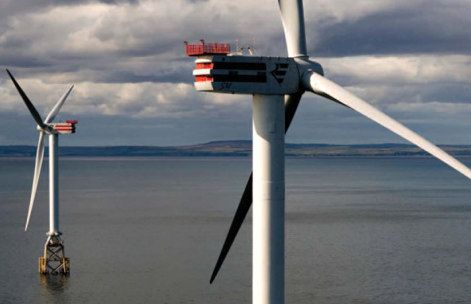
SEA of the OREDP for Ireland: NTS

2: Overview of the Offshore Renewable Energy                                                OREDP
Development Plan (OREDP)                                                                    Aim of the OREDP

                                                                                            The aim of the OREDP is to set out scenarios for the development of up to 4,500MW
                                                                                            from offshore wind energy and 1,500MW from wave and tidal energy in Irish waters up
Background
                                                                                            to 2030, including an initial review in 2015 and a full review in 2020, and to set out a
Under Directive 2009/28/EC, Ireland’s target is that 16% of all energy (heat, transport     longer term vision for the growth of the offshore renewable energy sector in Ireland.
and electricity) consumed is from renewable sources by 2020. In addition, the Irish
Government set its national targets for the production of energy from renewable             Objective of the OREDP
sources at 33% by 2020 (The Energy White Paper, 2007). This target was then
                                                                                            The objectives of the plan are to:
increased to 40% in the 2009 Carbon Budget.
                                                                                               Describe the policy context for development of the offshore marine renewable
National Renewable Energy Action Plan (Ireland)                                                 sector;

Ireland’s ‘National Renewable Energy Action Plan’ (NREAP) sets out how Ireland will            Provide information on the state of play on activities and initiatives that are
meet the overall target of 16% set out under Directive 2009/28/EC which will broadly be         underway in the marine renewable energy sector;
made up of 12% heat from renewable sources (RES-H), 10% transport from renewable               Set out some development scenarios for the period 2030; and
sources (RES-T) and 42.5% electricity from renewable sources (RES-E).                          Set out the long term vision for the sector.
The NREAP identifies that offshore renewable energy (offshore wind, wave and tidal
energy) will make a significant contribution to the RES-E element of Ireland’s overall      Main Proposals within the OREDP
renewable energy target.                                                                    The SEA is based on the main proposals set out in the OREDP which include a series
                                                                                            of scenarios for the development of up to 4,500MW from offshore wind and 1,500MW
Delivering Offshore Renewable Energy in Ireland                                             of wave and tidal energy within Irish waters. These development scenarios, as set out
Delivery of offshore renewable energy in Ireland is being approached from a technical       in Table 2.1 below are based on the following:
and strategic level. At a technical level, delivery is being actively supported through
                                                                                                     Low: This scenario consists of the 800MW of offshore wind to receive a grid
the National Strategy for Ocean Energy prepared in 2005 by the Marine Institute and
                                                                                                      connection offer under Gate 3. It also includes 75MW of wave and tidal
the Sustainable Energy Authority for Ireland (SEAI). This strategy includes a number
                                                                                                      development, which is included in the Table 10 modelled scenario in the
of initiatives including the establishment of wave and tidal testing facilities and
                                                                                                      National Renewable Energy Plan (NREAP).
supporting research and prototype development by industry.
                                                                                                     Medium: This scenario consists of 2,300MW of offshore wind, which comes
At a strategic level, the Government’s Sea Change: A Marine Knowledge Research and                    from the Table 10 non-modelled scenario of the NREAP (broadly based on
Innovation Strategy for Ireland 2007 – 2013 sets out key national level research and                  the combination of offshore wind projects with either foreshore lease or grid
economic initiatives for driving forward the development of the marine sector in Ireland.             connection) and the 500MW of wave and tidal energy in the same table (the
                                                                                                      Government’s 2020 ocean energy target).
                                                                                                     High: This scenario consists of 4,500MW of offshore wind and 1,500MW of
                                                                                                      wave and tidal current. These figures come from the SEA Scoping Report.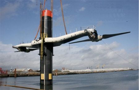
SEA of the OREDP for Ireland: NTS

Table 2.1: Development Scenarios

                             Development Scenarios to 2030
                                             Medium Scenario
                   Low Scenario (MW)                                High Scenario (MW)
                                                  (MW)
    Wind                    800                    2,300                   4,500
    Wave and
                            75                      500                    1,500
    Tidal

Longer Term Vision for the Growth of the Offshore Renewable Energy Industry

The plan also provides information on other areas and factors that potentially influence
the establishment and long term growth of the offshore renewable energy industry but
which are outside the scope of the OREDP and therefore do not form part of this SEA.

These include areas for growth and/or future investment such as the development of
grid connected test facilities and evolution of appropriate regulatory, consenting and
trading mechanisms.
The OREDP also identifies a number of factors that need to be addressed in the period
up to 2030 to enable the full exploitation of the natural resources within Ireland’s ocean
territory and for Ireland to become an exporter of offshore renewable energy to the rest
of Europe. These factors, which fall outside scope of the OREDP and therefore are not
part of this SEA, include:

    Technological advances in wave and tidal devices;
    Technological advances in harnessing wave, tidal and offshore wind energy in more
     arduous conditions such as off the west coast of Ireland;
    Grid developments to facilitate increased capacity;
    Increased joined up working with Northern Ireland, rest of the UK and Europe on the
     development of offshore grid;
    Development and provision of onshore infrastructure e.g. ports to support the
     construction and maintenance of offshore renewable energy developments.
    An improved and streamlined regulatory framework.
SEA of the OREDP for Ireland: NTS

                                                                                             Figure 3.1: Approach to the Assessment
3: Approach and Method

The approach applied to the assessment of the effects of offshore wind, wave and tidal

                                                                                              Assessment
                                                                                                Generic
energy developments on the marine and coastal environment of Ireland comprises                                     Generic assessment of offshore wind and marine renewable energy

                                                                                                Part 1:
three parts:                                                                                                       developments against SEA topics (non spatial assessment) based
                                                                                                                      on current knowledge and information from previous studies
     Part 1: Generic environmental effects (Chapter 10).

     Part 2: Detailed assessment of specific Assessment Areas (Chapter 11).

     Part 3: Cumulative assessment (Chapters 12 and 13).
                                                                                                                   Identify ‘Assessment Areas’                Identify key sensitive

                                                                                              Part 2: Assessment
                                                                                                                     based on offshore wind,               receptors located within the

                                                                                                of Assessment
Part 1 of the assessment (Generic Assessment) is non spatial. The focus of this part                                 wave and tidal resource               Assessment Areas based on
of the assessment is to provide a review of existing information and knowledge on the                               areas and areas of interest               baseline data review

                                                                                                     Areas
potential effects that the different technologies and device characteristics considered as                               for development
part of this SEA could have on the main environmental receptors covered by the SEA.
Parts 2 and 3 of the assessment focus on assessing the potential effects of the different
technologies and device characteristics, and cumulative effects of different amounts of                              Undertake more focused assessment (but still strategic level) of
development (MW) on the key environmental receptors known to be present within/or                                  potential effects of developing offshore wind (fixed and floating) and
associated with the main ‘Assessment Areas’ within the study area.                                                         marine renewable energy in the Assessment Areas

The purpose of the Assessment Areas is to:

    Improve the manageability of the study area.                                                                   Identify future development scenarios (based on known levels of
    Focus the assessment on the main areas of offshore energy resource (offshore                                    interest from developers and predicted future levels of interest)
     wind, wave and tidal) within Irish waters.

                                                                                              Part 3: Cumulative
    Reflect the main areas of current and future developer interest.

                                                                                                 Assessment
                                                                                                                        Assess potential effects of different levels of development
                                                                                                                         (development scenarios) within each Assessment Area
It is acknowledged that developers may seek to develop sites located outside the main
assessment areas. Although these sites may not be included in the Assessment Areas
this SEA does not preclude development outside these areas. These areas have                                        Assess cumulative effects of development across all Assessment
been covered by Part 1: Generic Assessment and any development in the study area                                    Areas and all SEA topics (Chapter 12) and transboundary effects,
(within or outwith the Assessment Areas) will also have to be considered on a case by                               relevant plans and programmes and other marine developments
case bases and subject to a project level Environmental Impact Assessment (EIA).                                                 and environmental issues (Chapter 13)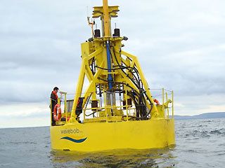
SEA of the OREDP for Ireland: NTS

Assessment Methodology                                                                    Presentation of Results
The method used in Parts 2 and 3 to assess the likely significance of potential effects   Part 1: Generic Assessment
on the majority of subjects covered by this SEA is summarised in Figure 3.2 below.        Results from Part 1 of the assessment are provided in Chapter 10 of the Environmental
This assessment method reflects an objective approach to the assessment of effects        Report (Generic Assessment). This includes a review of all potential effects for each of
e.g. effects have been assessed based on specific quantifiable facts and figures.         the stages of a commercial offshore renewable energy development from installation,
However, by nature, seascape assessments tend to be more subjective.                      through operation, maintenance to decommissioning for the different SEA subjects and
Consequently the method applied to the seascape assessment differs slightly from the      key environmental receptors.
method described below. This is necessary to reflect the more subjective nature of the
seascape assessment. Details of the seascape assessment are presented in Chapter          Part 2: Assessment of Assessment Areas
6 of the Environmental Report.                                                            The results of the ‘assessment area’ assessment (Part 2) are presented in a series of
Figure 3.2: Assessment Method                                                             matrices which include the following information:

                                                                                              SEA subjects where potential strategic environmental effects could occur.
           Identification of how offshore wind and marine renewable energy
                                                                                              Type of potential effect.
       technologies/device characteristics interact with the marine environment
                      (based on generic effects identified in Part 1).                        Phase of the development during which the potential effect is likely to occur e.g.
                                                                                               installation, operation, maintenance and decommissioning.
                                                                                              Device characteristics that are likely to give rise to potential effects.
       Identification of key receptors (in relation to SEA issues/subjects) located
                                                                                              Device types (offshore wind (fixed and floating), wave and tidal).
           within the Assessment Areas that could potentially be affected by
              commercial scale offshore wind, wave or tidal developments.                     Assessment of potential effect (effect without mitigation).
                                                                                              Summary of key environmental sensitivities (from baseline data) and description
                                                                                               of potential effect.
        Assessment of likely significance of potential effects of commercial scale            Description of possible project level mitigation measures that could be
           offshore wind, wave and tidal developments WITHOUT mitigation.                      implemented to reduce, avoid or offset possible adverse effects.
                                                                                              Assessment of potential residual effects (effects with mitigation).

       Identification of mitigation measures that could be implemented to reduce,
                                                                                          A summary of the key results from this assessment are presented in Section 6 below.
             avoid or offset the overall likely significance of potential effects.
                                                                                          Confidence levels have been assigned to the results from the assessment of the main
                                                                                          assessment areas to reflect the level of certainty by which conclusions can be drawn
        Assessment of residual effects (likely significance) of commercial scale          from the results. Confidence levels (low, medium and high) are of particular importance
              offshore wind, wave and tidal devices WITH mitigation.                      in terms of this SEA as they are necessary to reflect where known data and knowledge
                                                                                          gaps influence various results from the assessment.
SEA of the OREDP for Ireland: NTS
Mitigation measures Section 2: Dealing with Existing and Proposed Developments
Project level mitigation measures have been taken into account in the assessment of Existing and proposed developments have been taken into account in the assessment
likely significance of potential effects. Although it is acknowledged that the measures of the cumulative effects. However, it is not the focus of the SEA to examine individual
identified will not necessarily be incorporated into the plan (OREDP) they are sites for development.
recognised as current best practice and therefore these measures should be In terms of identifying the amounts (MW) of development that could be accommodated
incorporated into future projects. However, it is considered to be reasonable to in each Assessment Area (with and without environmental constraints), existing and
assume that they would be implemented by a responsible developer and that they are proposed developments have been taken into account in the overall total (MW) that
likely to be necessary in order to achieve consent at the project level e.g. as part of the could potentially be developed in an area. For example, in Assessment Area 1: East
EIA process. Coast (North), the assessment has identified that there is potential to develop between
1200MW and 1500MW from offshore wind without likely significant adverse effects on
the environment. However the assessment also recognises that of that 1200MW to
Cumulative Assessment 1500MW, 480MW have already been granted a foreshore lease or are due to receive
an offer of grid connection, therefore taking into account existing projects the remaining
The cumulative assessment was split into two sections:
resource in that Assessment Area is between 720MW and 1020MW.
Section 1: Cumulative effects: testing OREDP development scenarios (Chapter
12 of the Environmental Report).
Section 3: Other Plans, Programmes and Developments
Section 2: Cumulative effects: other plans, programmes and marine
developments (Chapter 13 of the Environmental Report). The cumulative assessment also considers the potential effects of implementing the
OREDP in combination with other marine developments implemented through other
plans and programmes. These include:
Section 1: Testing OREDP Development Scenarios
Requirements for the implementation of the OSPAR Convention, Habitats
The cumulative assessment is the main focus of the SEA. The aim for this part of the
Directive and Marine Strategy Framework Directive (MSFD)
assessment is to assess the potential effects that varying levels of development e.g.
numbers of commercial scale offshore renewable energy developments (offshore wind, Proposals for marine planning in Ireland.
wave and tidal) and total megawatts (MW) produced would have on the environment Transboundary effects of other plans and programmes in Irish, Northern Ireland,
within each of the assessment areas. rest of UK and European Waters such as the Ireland Offshore Strategic
Environmental Assessments (IOSEAs) 1 to 4, Northern Ireland Offshore
The results from this assessment are then reviewed in order to determine whether it
Renewable Energy Strategic Action Plan (ORESAP), The Crown Estate (UK)
would be possible to achieve the high level scenario presented in the OREDP for
leasing rounds for offshore wind (Rounds 1, 2 and 3 and Scottish Offshore Wind),
developing 4,500MW from offshore wind and 1,500MW from wave and tidal energy.
and the DECC UK Offshore Energy SEA 2 (OESEA2).
The results from this assessment are presented in Chapter 12 of the Environmental
Report and concluded in Section 7 of this NTS.SEA of the OREDP for Ireland: NTS
4: Technologies Wave and Tidal
The technologies for extracting energy from waves (wave height or energy from the
This SEA focuses on the following types of device: motion of waves) and tidal streams are still being developed and tested. Consequently
there are a wide range of different types of wave and tidal devices that needed to be
Offshore Wind (Fixed and Floating) taken into account in the SEA. Some of the different devices are illustrated below:
Wave
Tidal Stream
Offshore Wind (Fixed and Floating)
Offshore wind devices are generally the most advanced and standardised types of
devices. The most common type of commercial scale offshore wind farm that is
deployed today is the Horizontal Axis wind turbine:
Horizontal Axis Wind Turbine
Each turbine has a capacity of between 3MW
and 5MW. They have a height from base to tip
of around 80m to 120m and a tower height of
about 60m to 80m. The blades are typically
40m long.
Most offshore wind developments to date have
been built in shallower water (e.g. less than
30m depth) with either piled or gravity base
foundations. However, new devices are
currently being tested that would enable
deployment in deeper water e.g. 40m to 60m
depth.
Arklow Bank, East Coast of Ireland.
These include turbines that use quadropod jacket bases in waters of around 45m depth
and floating devices which use moored platforms and are currently being tested at full
(Sources: clockwise from top left: AquaMarine Power (Oyster), Ecofys, Hammerfest HS1000,
scale. These could enable windfarms to be developed in much deeper waters e.g.
Pelamis Wave Power Ltd, OpenHydro, Marine Current Turbines Ltd (SeaGen), Wavebob).
more than 100m depth.SEA of the OREDP for Ireland: NTS
5: Offshore Renewable Energy Resource The Assessment Areas listed below extend out from the coast (mean high water mark)
to a distance of 100km from shore. This reflects the upper length limit of Alternating
Current (AC) export cable technology. For distances greater than 100km Direct
Overview of Potential Resource Current (DC) cables will be required, with convertor stations on land to convert to AC).
Chapter 8 of the ER identifies that there is a huge potential resource of offshore wind Table 5.1: Assessment Areas
and wave energy in the waters around Ireland, in particular off the west coast where the
prevailing westerly winds and wave fetch (distance of open water over which waves are Assessment Area Technology Location
formed) are strongest. There also some smaller, more discrete areas of tidal resource.
1 Wind East Coast - North
These are mainly located off the east coast and northwest coast around Donegal. Tidal
1
resource was also identified in the Shannon Estuary. 2 Wind & Tidal East Coast - South
2
However, most of the resource identified is purely theoretical, in that whilst it exists, a 3 Wind South Coast
large proportion of it cannot be exploited for a number of reasons, mainly relating to the
4 Wind & Wave West Coast - South
technical feasibility and economic viability of harnessing energy from such extreme,
harsh and challenging environments. However there are a number of locations off the 5 Wind & Wave West Coast
coast of Ireland where there are potential opportunities for exploiting the available 5a Tidal Shannon Estuary
offshore wind, wave and tidal resources.
1
6 Wind & Wave & Tidal West Coast - North
Assessment Areas
Note 1: Wave resource is not considered in Assessment Area 3, as although there is
In order to make the make the study area more manageable and provide more detail some resource in this area it was considered to be too far offshore for development
and focus to the assessment of cumulative effects the study area was split into seven within the timeframe of the SEA. It was decided to only focus on wave resources in the
Assessment Areas. Key factors used in identifying these Assessment Areas include: more accessible near shore areas on the southwest, west and northwest coast where
developer interest is predicted to be initially focused (Assessment Areas 4, 5 and 6).
The extent of available resource (theoretical and technical) for offshore wind,
Note 2: Only those areas of significant tidal resource suitable for the development of
wave and tidal (based on information in Chapter 8 of the ER).
commercial tidal arrays were considered in the assessment. It is recognised that there
Development/operating parameters and constraints associated with each of the are a number of smaller discrete areas of tidal resource around the Irish coast.
technologies as discussed in Chapter 7 of the ER. However, due to their scale these areas were only considered to be more suitable for
Feedback from developers on current and possible future areas of interest for demonstration or test projects rather than full scale commercial developments. The
developments. exception to this is the Shannon Estuary where both developers and environmental
authorities have indicated that there is interest in the development of a commercial
Review of current development patterns taking into account technical feasibility of
scale tidal array in this area.
where development is likely to occur.
The Assessment Areas are illustrated in Figure 5.1 below.SEA of the OREDP for Ireland: NTS
Operating Parameters
The operating/development parameters used to assist the identification of the potential
resource within the study area are presented in Table 5.2 below:
Table 5.2: Development/Operating Parameters
Development/Operating Fixed Floating
Tidal Wave
Parameters Wind Wind
60m to 10m to
Water Depth 10m to 60m 20m to 80m
200m 100m
Mean
annual
> 7.0 m/s > 7.0 m/s wave
Peak
mean mean power
Spring
annual annual (kilowatts)
Constraining Threshold Current
wind speed wind speed per metre
Flow >1.2
at 100 m at 100 m of wave
m/s
height height crest (WC)
>20
kW/mWC
2
Approximate MW/km 10 10 50 10
Average Turbine/Device 0.5 MW to
5 MW 2.3 - 5 MW 1 MW
Generating Capacity 5 MW
Average Scale of MW 300 MW 300 MW 50 MW 30 MW
Commercial
2 2 2 2 2
Development Km 30km 30km 1km 3km15°0'W 12°0'W 9°0'W 6°0'W 3°0'W
Strategic Environmental Assessment
of Wave, Tidal and Offshore Wind
.
Development in Irish Waters
56°0'N
56°0'N
Figure 5.1: Assessment Areas
Legend
!
Background
Ireland
!
!
55°0'N
55°0'N
!
United Kingdom
6) West Coast - North
!
Study area
!
12nm limit
!
! !
!
Assessment Areas
!
! ! !
Wind
!
!
Tidal
54°0'N
54°0'N
!
Wind and Wave
!
Wind and Tidal
!
!
Wind, Wave and Tidal
!
!
!
1) East Coast - North
!
!
!
!
!
5) West Coast
53°0'N
53°0'N
!
!
!
!
!
!
!
!
!
2) East Coast - South
!
5a) Shannon
!
!
!
!
!
!
52°0'N
52°0'N
!
!
!
!
!
!
!
!
!
!
Note 1: Assessment Areas extend from the coast (Mean High Water)
!
!
to a distance of 100km, within the boundary of the Irish Exclusive
!
!
Economic Zone only
!
!
!
!
Note 2: Not to be used for navigation
4) West Coast – South
!
!
3) South Coast
!
! !
!
51°0'N
!
51°0'N
!
km
!
!
0 35 70 140 210 280
Date Monday, October 4, 2010 10:25:45
Projection WGS_1984_UTM_Zone_29N
5) West Coast Spheroid WGS_1984
50°0'N
50°0'N
Datum D_WGS_1984
Data Source SEI, GEBCO, UKHO
5a) Shannon
J:\P1304\Mxd\Final Figures\.mxd
File Reference
5.1 Assessment Areas
Produced By Louise Mann
Checked
49°0'N
49°0'N
Reviewed By Sally Holroyd
5) West Coast
This product has been derived in part from material obtained from the UK Hydrographic Office with the permission
of the Controller of Her Majesty's Stationery Office and UK Hydrographic Office (www.ukho.gov.uk).
15°0'W 12°0'W 9°0'W 6°0'W 3°0'W © British Crown & SeaZone Solutions Limited. All rights reserved. © Metoc plc, 2010.
Products Licence No. 122009.010. All rights reserved.SEA of the OREDP for Ireland: NTS
Assessment Areas Key Receptors
6: Assessment of Assessment Areas - Results
Main shellfisheries include Nephrops, cockles, razor clams
and periwinkles.
The following section provides a summary of the following: Main fin fisheries include whitefish, whiting, haddock, black
sole and plaice.
High shipping intensity in the area with vessels entering
Key sensitive receptors located within/associated with the main Assessment
Dublin and surrounding ports.
Areas. Assessment Area 1: Main seascape types include low plateau (Type 3) and low
Summary of the likely significance of potential effects of the different technologies East Coast (North) lying coastal plain (Type 4). These are generally
on the key sensitive receptors taking into account mitigation (residual effects). considered to have low sensitivity to offshore wind and
other offshore renewable energy developments. However,
there are areas of higher seascape sensitivity.
Two offshore wind areas, due to receive a grid connection
Sensitive Receptors offer and awaiting a foreshore lease decision by the
Table 6.1 below provides an overview of the key sensitive receptors located within each Minister in the area (Oriel and Dublin Array).
of the Assessment Areas. However, it should be noted, the marine environmental off Number of protected sites including three SACs
designated for benthic habitats, eight SPAs, one Ramsar
the coast of Ireland is very rich, diverse and extensive. A full description of Ireland’s
site and six IBAs.
marine environment (based on information available as of October 2010) is provided in
Isolated bird colonies with counts between 500 and 2500.
Chapter 9 of the Environmental Report.
One small population of grey seals and two small
Table 6.1: Summary of Key Receptors populations of harbour seal.
Some sightings of bottlenose dolphin, harbour porpoise,
Assessment Areas Key Receptors leatherback turtle and some occasional isolated sightings
Large number of protected sites including eight SACs of basking shark.
designated for benthic habitat, one SAC designated for Nursery areas for mackerel, cod, horse mackerel and
marine mammals, 17 SPAs, 13 Important Bird Areas Assessment Area 2: whiting and spawning areas for whiting.
(IBAs), six Ramsar sites and three MPAs. East Coast (South) Main shellfisheries include edible crab, scallops, oyster,
Number of seabird colonies with population counts of periwinkle and whelks.
30,000 to 70,000. Fin fisheries include cod, ray species, black sole and
Assessment Area 1: plaice.
There are some populations of grey and harbour seal.
East Coast (North) High shipping intensity in particular for cargo vessels
There have also been some sightings of bottlenose
dolphin, harbour porpoise, leatherback turtle and basking leaving Wexford.
shark. Rosslare is major commercial and ferry port.
Nursery areas for mackerel, cod, haddock, herring, horse Main seascape types include the less sensitive low plateau
mackerel and whiting. (Type 3) and low lying coastal plain (Type 4).
Spawning areas for cod, herring and whiting. Arklow Bank existing windfarm lease area, southern
section of Dublin Array and Codling Bank lease area.SEA of the OREDP for Ireland: NTS
Assessment Areas Key Receptors Assessment Areas Key Receptors
Large number of protected sites including 10 SACs Number of bird colonies with counts of 10,000 to 30,000.
designated for benthic habitats, two SACs designated for There are significant populations of harbour and grey seal.
marine mammals, five SPAs, seven Ramsar sites, one There have been significant sightings of harbour porpoise,
MPA (Tramore Dunes and Mudflats) and 14 IBAs. bottlenose dolphin, leatherback turtle and basking sharks.
Largest bird colony is on Saltee Island with population Nursery areas for mackerel, cod, blue whiting, haddock,
counts of 10,000 to 30,000. hake, horse mackerel, megrim, whiting, white belly angler
Small populations of harbour and grey seals. Larger monk and black belly angler monk.
population of grey seals in the east. Spawning grounds for mackerel, haddock, herring, horse
There have been large numbers of bottlenose dolphin and mackerel and whiting.
harbour porpoise sightings, sightings of leatherback turtle Shellfisheries in the area include Nephrops, edible crab,
and significant sightings of basking shark. lobster, shrimp, spider crab and scallops.
Nursery areas for mackerel, cod, haddock, hake, herring, Fin fisheries include angler fish, megrim, black sole, plaice,
megrim, whiting, white belly angler monk and black belly hake and haddock.
angle monk. Shipping intensity is generally low to moderate with a
Spawning areas for mackerel, cod, haddock, horse Assessment Area 4: greater number of tankers and cargo vessels than
Assessment Area 3:
mackerel, megrim and whiting and herring. West Coast (South) passenger vessels.
South Coast
Shellfisheries in the area include Nephrops, edible crab, Main ports include Bantry Bay and Castletownbere.
lobster, shrimp, scallop, crayfish, whelk and oyster. Large number of marinas and sailing clubs, surf spots,
Fin fisheries include herring, cod, haddock, whiting, angler blue flag beaches and coastal walks.
fish, megrim, hake, black sole, plaice and ling. Large part of the coast forms part of the Skellig Micheal
Shipping intensities within the area are generally moderate World Heritage Site (WHS).
with higher shipping intensities around the ports of Cork Main seascape type in this area is rugged peninsulas with
and Waterford. drowned valleys and large bays, both of which are highly
There are a number of marinas, surf spots, blue flag sensitive to offshore wind and other offshore renewable
beaches and coastal walks. energy developments.
Three seascape types including low lying plateau, low lying Seascape character is an integral part of the overall
coastal plain and large bays. Large bays are most character and atmosphere of the WHS.
sensitive to offshore wind farms. There are some dredging and disposal sites in the area.
There are five dredging and disposal sites in the area. Hibernia D telecommunications cables passes through the
There are also a number of oil and gas lease/exploration area.
areas and infrastructure. Significant number of protected sites including 21 SACs
There are a very large number of protected sites including Assessment Area 5: designated for benthic habitats and species, ten SACs
Assessment Area 4: eight SACs designated for benthic ecology, five SACs West Coast designated for marine mammals, 22 SPAs, six MPAs, four
West Coast (South) designated for marine mammals, nine SPAs, five MPAs, (Central) Ramsar sites and 18 IBAs.
one Ramsar site and nine IBAs. Large number of bird colonies.SEA of the OREDP for Ireland: NTS
Assessment Areas Key Receptors Assessment Areas Key Receptors
Significant populations of harbour seal and breeding Significant number of protected sites including 20 SACs
populations of grey seal. designated for benthic habitats and species, 12 SACs
Significant sightings of harbour porpoise and bottlenose designated for marine mammals, 29 SPAs, two MPAs, four
dolphin, large number of sightings of leatherback turtle and Ramsar sites and 14 IBAs.
occasional sighting of basking shark. Large number of bird colonies.
Suggested migratory corridor for humpback whale. Significant populations of harbour seal and breeding
Nursery area for mackerel, cod, blue whiting, haddock, populations of grey seal.
hake, herring, horse mackerel, megrim, whiting, white belly Significant sightings of harbour porpoise and bottlenose
angler monk and black belly angler monk. dolphin, leatherback turtle and basking shark.
Spawning areas for mackerel, blue whiting, haddock, hake, Nursery areas include mackerel, cod, haddock, hake,
herring, horse mackerel, megrim and whiting. herring, horse mackerel, megrim, white belly angler monk
Shellfisheries include Nephrops, edible crab, spider crab, and black belly angler monk.
lobster, shrimp and oyster. Spawning grounds for mackerel, whiting, haddock, hake
Fin fisheries include haddock, megrim, black sole, hake and herring.
and angler fish. Shellfisheries include Nephrops, edible crab, lobster,
Assessment Area 5:
Shipping intensity is low to moderate with more tankers shrimp and oyster.
West Coast
and cargo vessels than passenger vessels. Assessment Area 6: Fin fisheries include cod, haddock, megrim, black sole,
(Central)
High number of marinas, sailing clubs, surf spots and West Coast (North) whiting, plaice, ray and ling.
clubs, blue flag beaches and coastal walks. Shipping intensity is low to moderate with a moderate
Submarine exercise and transit area to the north. amount of cargo vessels.
Varied and complex seascape character with number of Two major ports include Sligo and Killybegs.
seascape types including large bays and sea loughs, Large number of marinas, sailing clubs, surf clubs and surf
offshore islands, dramatic high cliffs, peninsula’s and spots, blue flag beaches and coastal walks.
headlands, sandy flats and flat or low lying complex Large submarine exercise and transit area.
islands and peninsulas. These seascape types are all of Complex and varied seascape with number of seascape
moderate to high sensitivity to offshore wind and other character types including large bays and sea loughs,
offshore renewable energy developments. numerous offshore islands, dramatic high cliffs,
Three potential nominees to the World Heritage List. peninsula’s, headlands, sandy flats, flat/low lying complex
There are a number of dredging and disposal sites. islands and peninsulas. These seascape types are all of
Gas pipeline to the north that runs to the Corrib Gas field. moderate to high sensitivity to offshore wind and other
Number of power and telecommunications cables offshore renewable energy developments.
connecting the mainland to Inis Bo Finne and Aran Islands. No active oil and gas development.
Area covered by the Lower River Shannon SAC which is Hibernia A telecommunications cable passes through this
Assessment Area
designated for bottlenose dolphins and number of SPAs. assessment area.
5a: Shannon
High intensity of shipping movements through main part of
Estuary
estuary.SEA of the OREDP for Ireland: NTS
Summary of Potential Effects Summary of Effects
Biodiversity, Flora and Fauna
Summary of Effects
Benthic ecology, marine mammals, seabirds and fish - habitat exclusion: All three
Water, Soil and Sediment
technologies could lead to habitat exclusion through occupying areas of the seabed,
Geology, geomorphology and sediment processes – scouring: There is potential surface and water column. The overall effect of this is unknown but is likely to be more
that the presence of structures on the seabed, in particular piled foundations, could significant in areas used by breeding (marine mammals), feeding (marine mammals,
lead to localised scouring of the seabed, in particular where the sediment comprises fish and seabirds) and spawning (fish). The likely significance of residual effects is
sand and gravel. Potential significant adverse effects could be reduced by careful site unknown. However, potential likely significant adverse effects could be avoided or
selection informed by hydrodynamic modelling at the project stage. The likely reduced by siting developments outside protected sites, breeding, feeding and
significance of residual effects will be negative to negligible. spawning areas. Time constraints for construction could also mitigate against effects.
Geology, geomorphology and sediment processes – changes in coastal Marine mammals, marine reptiles, seabirds and fish - collision risk from
processes: Potential significant adverse effects on coastal process resulting from the operational wave and tidal devices: the potential effects of collision with operational
extraction of energy from the existing wave and tidal regime could be reduced or devices on marine mammals, marine reptiles, fish and seabirds (diving and pursuit) are
avoided through careful site selection and modelling. The likely significance of unknown. However, it is likely that these effects will be greater for tidal devices than
residual effects will be negative to negligible. wave devices which generally have lower rates of motion and fewer moving parts.
Likely residual effects are currently unknown, although with increased information on
Accidental contamination from devices and vessels as a result of storm damage
species distributions and their interactions with tidal devices and appropriate siting of
or failure or collision – this could occur in all assessment areas for all types of
devices the potential for a likely significant adverse effect could be reduced.
development (offshore wind, wave and tidal). Should this occur it is likely to have a
significant adverse effect on water quality, birds, marine mammals, marine reptiles, Marine mammals, marine reptiles, seabirds and fish - collision risk from
benthic ecology and fish and shellfish. However, the likelihood of this occurring is low operational offshore wind farms: Operational offshore wind farms could potentially
and the risks of contamination from devices can be reduced through appropriate have a significant adverse effect on birds in flight, in particular on key migratory routes.
designs and integration of mechanisms to protect against any leakage of potential The significance of any potential effects on marine mammals, marine reptiles and fish
contaminants should a device get damaged or failure occur. The likely significance of colliding with offshore wind turbine foundation structures is likely to be negligible and
any residual effects is therefore negligible. the level of harm would be low given there are no moving parts. The likely significance
of residual effects for birds is negative and other species are negligible.
Biodiversity, Flora and Fauna
Marine mammals, marine reptiles, fish and seabirds - noise from the installation
Benthic ecology – substratum loss: All three technologies could potentially have of piled devices: In terms of the installation of devices the most significant source of
significant adverse effects on benthic habitats and species due to substratum loss noise is from the piling of offshore wind and tidal turbine foundations. Noise from piling
resulting from the attachment of devices to the seabed. These effects are likely to be activities can have significant adverse effects on marine mammals, marine reptiles, fish
greatest for piled devices and gravity bases. With increased information on species and possibly seabirds (diving and pursuit feeders). Although potential effects can be
and habitat distributions and abundance and appropriate siting of developments to reduced by avoiding breeding and spawning seasons and well as using Marine
avoid sensitive habitats and species the likely significance of any residual effects Mammal Observers, exclusion zones, passive noise monitoring, pingers or bubble
would be negative/negligible. curtains the likely residual effects are still likely to be negative to significant adverse.SEA of the OREDP for Ireland: NTS
Summary of Effects Summary of Effects
Biodiversity, Flora and Fauna Cultural Heritage including Archaeological Heritage
Marine mammals, marine reptiles, fish and birds - noise from the operation of Damage or loss to archaeological remains / historic features – there is potential
tidal devices: In terms of the three technologies, tidal devices currently have the that device installation and cabling activities could have a significant adverse effect on
greatest potential to generate underwater noise from the frequent and regular archaeological sites and features (marine and coastal). However, with appropriate site
movement of submerged turbines (wave moving parts tend to be at or above the investigations and appropriate siting of devices and routing of cables, the likely
surface, wind moving parts are all above surface). There is potential for noise from significance of any residual effects would be negligible.
operational tidal devices could affect fish, marine mammals and seabirds (diving and
Population and Human Health
pursuit) in terms of habitat exclusion and disorientation. However, the likely
significance of any residual effect is unknown. Commercial fisheries- direct disturbance of commercial fishing grounds: The
Marine mammals, marine reptiles, fish and birds - barriers to movement: There is physical presence of devices and associated cables or noise generated by piling
still uncertainty over the potential effects of commercial arrays (all technologies) on activities and the operation of devices could potentially have a significant adverse effect
marine mammals, marine reptiles and fish (particularly migratory species e.g. salmon) on fishing grounds. However, through appropriate siting of devices outside key
in terms of creating barriers to movement. Barriers to movement are more likely to traditional commercial fishing grounds and key nursery and spawning areas the likely
occur in constrained areas e.g. Lough mouths, inter-island channels and around significance of any residual effects could be reduced to negative or negligible.
headlands. These tend to coincide with areas of tidal resource. The potential causes of Commercial fisheries - long term displacement from fishing grounds: The
barriers to movement include noise from arrays/devices, a perceived risk of harm from presence of an offshore renewable energy development in certain locations could lead
collision with moving parts and the presence of physical barriers, which are more likely to the displacement of fishermen from key fishing grounds. Although, through the
be caused by tidal developments although large wave arrays may also create physical appropriate siting of developments potential adverse effects could be reduced, the
barriers in areas of open water. Although potential barriers to movement could be likely significance of the effect depends on the importance of the fishing ground and
reduced by limiting the number of developments in constrained areas, avoiding key whether displacement would lead to increased pressure on stocks in other areas.
migratory routes and feeding/breeding transit areas and modifying the Therefore the likely significance of any residual effects could potentially range from
configuration/layout of certain developments to minimise the creation of physical significant adverse to negligible across the different assessment areas.
barriers, the likely significance of any residual effects is still unknown.
Commercial fisheries - recovery of fish stocks: The exclusion of commercial fishing
EMF Impacts – whilst there is no evidence that operating power cables have caused a activities from certain areas could have positive residual effects on fish stocks in certain
change to behaviour and migration for marine fish, reptiles and mammal species, there locations.
is evidence that some species of fish and marine reptiles can detect electric fields, and
Mariculture: Shellfish and finfish farming areas are unlikely to be directly affected by
circumstantial evidence that cetaceans can detect magnetic fields. Given that most of
the existing anecdotal evidence demonstrating lack of an avoidance reaction is based offshore renewable energy developments directly but could be affected by the
on operating interconnectors, and the effect of interturbine cable arrays could cause a installation of export cables (substratum loss or disturbance and smothering). All shell
more concentrated effect, the scientific community believes that more research is and fin fish farms would need to be avoided as part of the design and detailed export
needed to quantify this potential effect. The significance of any likely residual effects is cable routes to prevent any likely significant adverse effects from cabling activities.
unknown.SEA of the OREDP for Ireland: NTS
Summary of Effects Summary of Effects
Population and Human Health Population and Human Health
Shipping and navigation - reduced navigational safety and collision risk: The Indirect effects on recreational assets/features: potential effects on wildlife, bathing
presence of arrays in navigational and shipping channels can affect navigational safety water quality and seascape/visual amenity are covered under the specific topics.
and increase the risk of collision either directly or by displacing vessels into areas However, there is the potential that any likely significant adverse effects on these
where there is a higher intensity of vessel movements. The significance of these features would also have indirect effects on these important recreational assets.
effects depends on the type of development and the intensity of vessel movements in Measures to reduce or avoid likely significant effects are discussed in reference to the
certain locations. In terms of the device types the level of displacement is likely to be relevant SEA subjects.
greater for wind and wave developments as these tend to occupy larger areas than
Aviation collision risk: There is the potential for aircraft to collide with devices that
tidal developments which have much higher energy densities and therefore occupy
protrude above the surface water (mainly offshore wind developments). The potential
smaller areas. Wind and wave devices also occupy entire water column (wind) or sea
effects of this collision risk are likely to be adverse significance where developments
surface (wave) where as tidal devices could potentially be fully submerged at depths
are located on main flight paths from airports. There is also the potential for collision
which would allow shipping and tidal developments to co-exist. Likely residual effects
with search and rescue operations (helicopter and plane.) However, given that there
in areas of high vessel movements could be significant adverse. However, in areas of
are no ‘Potential to Interfere’ areas within any of the assessment areas the likely
lower vessel densities the likely significance of any potential effects is likely to reduce to
significance of these potential effects can be reduced by siting developments away
negative or negligible.
from major flight paths and search and rescue deployment areas ensuring offshore
Increased navigational safety: In some locations the presence of offshore renewable wind turbines are lit with aviation lights in accordance with the ‘Offshore Wind Farms
energy developments may act as navigational aids by marking out and creating an area Conspicuity Requirements’
of exclusion around potentially hazardous areas of water such as submerged
Radar interference: Potential effects from radar interference are only likely to be
sandbanks. However, the likely significance of this potential effect will depend upon the
generated by offshore wind farm developments as wave and tidal devices generally do
number of vessel movements in an area and the overall effects of the developments in
not protrude more than a few meters above the water surface. As there are no
terms of wider displacement of vessel movements into other shipping channels.
‘Potential to Interfere’ NERL areas within the study area the likely significance of any
Recreation and tourism: There are a number of marine and coastal recreational residual effects from offshore wind farms are likely to be negligible.
activities that occur across the study area, and could therefore be affected or disrupted
Military practice areas: Although these overlap with all of the assessment areas
by commercial offshore renewable energy developments either directly (disruption to or
information on the nature and frequency of the activities that occur in these practice
exclusion from recreational sailing areas) or in directly through effects on visual amenity
areas was not available for this SEA. Therefore the potential effects could range from
and seascape quality. Any likely significant adverse effects can be reduced by siting
significant adverse to negligible.
developments outside the main sailing and watersports areas. Additional navigational
aids may be also be required for developments located near to main recreational sailing
routes to reduce the potential collision risk. The likely significance of residual effects is
likely to range from negligible to negative depending on the location of individual
developments.You can also read