Transport Assessment Part 1 of 7 - May 2018 Arup - Canada Water Masterplan
←
→
Page content transcription
If your browser does not render page correctly, please read the page content below
Transport Assessment
Part 1 of 7

May 2018
Arup
1.    Introduction ............................................................. 2
2.    Planning Policy........................................................ 4
3.    Existing Site ........................................................... 15
4.    Canada Water Strategic Transport Study ........... 25
5.    Existing Transport Conditions ............................. 28
6.    Proposed Transport Improvements and Future
      Baseline .................................................................. 62
7.    Proposed Development ........................................ 81
8.    Trip Generation and Mode Split ........................... 93
9.    Transport Impacts ............................................... 118
10.   Intervention Testing ............................................ 150
11.   Travel Plan ........................................................... 162
12.   Deliveries and Servicing ..................................... 164
13.   Construction ........................................................ 166
14.   Conclusions ......................................................... 168

                                                                              Page 1
Masterplan Transport Assessment
1. Introduction
1.1.1 This Transport Assessment (TA) has been prepared by Arup and is submitted in
support of a hybrid planning application for the Canada Water Masterplan. The hybrid
planning application is made in relation to land bounded by Surrey Quays Road to the
north, Lower Road (A200) to the west, Redriff Road (B205) to the south and Quebec
Way to the east (the “Site”) on behalf of BL CW Holdings Ltd, a subsidiary of British
Land Company Plc (“The Applicant”), hereafter referred to as “British Land”. The hybrid
planning application is formed of detailed development proposals in respect of Plots A1,
A2 and K1 for which no matters are reserved ("Detailed Proposals"), and outline
development proposals for the remainder of the Site, with all matters reserved ("Outline
Proposals"). The Detailed Proposals and Outline Proposals together are referred to as
the “Development”.
1.1.2 The Development comprises the comprehensive redevelopment of the Surrey Quays
Shopping Centre, former Harmsworth Quays Printworks and Surrey Quays Leisure
Park sites, former Dock Offices Courtyard, former Rotherhithe Police Station and land
at Roberts Close. The Development will provide new retail, office, leisure and
community floorspace along with residential dwellings. The Development will also
provide significant, high quality public realm, including a new Town Square, a new High
Street and a public park.
1.1.3 The purpose of this TA is to assess the effect of the Development in terms of traffic and
transport impacts. Separate Transport Statements have been prepared in parallel for
each of the Plots that form the Detailed Proposals.
1.2 TRANSPORT ASSESSMENT STRUCTURE
1.2.1 Following this introductory chapter, the Transport Assessment is structured as follows:
Chapter 2 outlines the policy context for the Development and the guidance that has
been referenced in preparing the Transport Assessment;
Chapter 3 sets out the site location, existing site uses and committed development
proposals either on or adjacent to the Site;
Chapter 4 explains the background to the Canada Water Strategic Transport Study
undertaken by Transport for London (TfL), Southwark Council and British Land, which is
used to inform the Transport Assessment;
Chapter 5 identifies the existing transport context, including facilities for pedestrians,
cyclists, public transport users and drivers;
Chapter 6 sets out the future baseline conditions without the Development, outlining
committed and proposed transport improvements and the impacts of background
growth;
Chapter 7 outlines the Development proposals, including the land uses and floor areas
for which permission is being sought together with physical provision that is proposed to
support transport and access within the Site;
Chapter 8 explains the approach that has been used to assess the transport impacts of
the Development and the consequent assessment of trip demands associated with it;
Page 2
Masterplan Transport Assessment
Chapter 9 sets out the transport impacts of the Development, including the physical
provision contained within the design proposals explained in Chapter 7, against the
future baseline outlined in Chapter 6;
Chapter 10 tests the measures which are proposed to mitigate the impacts shown in
Chapter 9, in addition to the provision included within the Development proposals;
Chapter 11 explains the Framework Travel Plan that will be used to mitigate
development impacts and embed the transport strategy in a way that filters down to site
users;
Chapter 12 sets out the approach to deliveries and servicing;
Chapter 13 explains the approach to construction and the assessment of the
construction stages of the Development; and
Chapter 14 summarises the conclusions of the Transport Assessment.
1.3 PRE-APPLICATION CONSULTATION
1.3.1 Community consultation on the Canada Water Masterplan started in Spring 2014, and
further public consultations have been held on a regular basis as the Masterplan has
developed. There have been over 40 events to date, with over 3,000 people involved,
most recently in January 2018.
1.3.2 Through these public consultations transport has been a key theme of discussion, and
the transport strategy that underpins the Development has taken on board community
feedback, as well as comments from other key stakeholders.
1.3.3 Most significantly, Arup and British Land have held a wide range of pre-application
discussions with Southwark Council and TfL and where relevant, these have been
referenced in the Transport Assessment.
1.3.4 Formal pre-application meetings were held with Transport for London and Southwark
Council in December 2017 and February 2018, and the advice received as a result of
these meetings is included in Appendix A.
1.3.5 In addition to these formal meetings, a large number of meetings on specific transport
topics have been held with Southwark Council, TfL and the Greater London Authority
(GLA) during the development of the application proposals.
1.3.6 Further meetings have also been held to progress the Canada Water Strategic
Transport Study (STS) which is being undertaken by TfL and Southwark Council and is
discussed in more detail in Chapter 4. The Canada Water STS looks to assess the
impact of development across the whole of the Canada Water Opportunity Area,
including proposals by British Land and by other developers such as Notting Hill
Housing / Sellar and Kings College London. A number of further transport studies have
arisen as a result of work on the STS, particularly into how conditions at Canada Water
and Surrey Quays stations can be improved. These are being taken forward by TfL.
British Land is committed to a continued close working relationship with TfL and
Southwark Council to help progress and facilitate these studies and their outcomes.
Page 3
Masterplan Transport Assessment
2. Planning Policy
This section outlines the relevant national, regional and local transport policy and
planning guidance documents which form the context for the Development proposals.
2.1 NATIONAL POLICY
National Planning Policy Framework (DCLG, 2012)
2.1.1 The Department for Communities and Local Government (DCLG) published the
National Planning Policy Framework (NPPF) in 2012. The NPPF replaces the previous
planning policy guidance (PPG) and planning policy statement (PPS) documents.
2.1.2 With specific reference to transport, the NPPF states that “The transport system needs
to be balanced in favour of sustainable transport modes, giving people a real choice
about how they travel”.
2.1.3 The NPPF also indicates that “…developments should be located and designed where
practical to:
Accommodate the efficient delivery of goods and supplies;
Give priority to pedestrian and cycle movements, and have access to high quality
public transport facilities;
Create safe and secure layouts which minimise conflicts between traffic and cyclists
or pedestrians, avoiding street clutter and where appropriate establishing home
zones;
Incorporate facilities for charging plug-in and other ultra-low emission vehicles; and
Consider the needs of people with disabilities by all modes of transport”.
The NPPF indicates that “a key tool to facilitate this will be a Travel Plan. All
developments which generate significant amounts of movement should be required
to provide a Travel Plan”.
2.1.4 In March 2018 revisions to the NPPF were consulted on. This included changes to the
structure of the transport chapter, as well as providing clarity that new developments
should prioritise pedestrian and cycle movements through their design, followed by
access to high quality public transport.
2.2 REGIONAL POLICY
The London Plan (Greater London Authority (GLA), March 2016)
2.2.1 The London Plan’s transport policies are primarily intended to support delivery of the
objective that London should be “a city where it is easy, safe and convenient for
everyone to access jobs, opportunities and facilities with an efficient and effective
transport system which actively encourages more walking and cycling…”.
2.2.2 Policy 6.1 indicates that “the Mayor will work with all relevant partners to encourage the
closer integration of transport and development...” by:
Page 4
Masterplan Transport Assessment
“Encouraging patterns and nodes of development that reduce the need to travel,
especially by car...;
Seeking to improve the capacity and accessibility of public transport, walking and
cycling, particularly in areas of greatest demand – boroughs should use the
standards set out in Table 6.3 in the Parking Addendum to set minimum cycle
parking standards;
Supporting development that generates high levels of trips at locations with high
public transport accessibility and/or capacity, either currently or via committed,
funded improvements including, where appropriate, those provided by developers
through the use of planning obligations...;
Supporting measures that encourage shifts to more sustainable modes and
appropriate demand management; and
Promoting walking by ensuring an improved urban realm”.
2.2.3 Policy 6.3 states that “development proposals should ensure that impacts on transport
capacity and the transport network, at both a corridor and local level, are fully
assessed”. The policy also indicates that “transport assessments will be required in
accordance with TfL’s Transport Assessment Best Practice Guidelines for major
planning applications. Workplace and/or Residential Travel Plans should be provided
for planning applications exceeding the threshold in, and produced in accordance with,
the relevant TfL guidance. Construction logistics plans and delivery and servicing plans
should be secured in line with the London Freight Plan and should be co-ordinated with
travel plans”.
2.2.4 Policy 6.9 states that “the Mayor will work with all relevant partners to bring about a
significant increase in cycling in London, so that it accounts for at least 5% of the modal
share by 2026. He will:
Identify, promote and complete the Cycle Super Highways...; and
Implement the central London cycle hire scheme and identify potential sites for
expansion and/or additional standalone schemes in outer London”.
2.2.5 The policy also states that “Developments should:
Provide secure, integrated and accessible cycle parking facilities in line with the
minimum standards...;
Provide on-site changing facilities and showers for cyclists;
Facilitate the Cycle Superhighways...; and
Facilitate the central London cycle hire scheme”.
2.2.6 Policy 6.10 indicates that “the Mayor will work with all relevant partners to bring about a
significant increase in walking in London, by emphasising the quality of the pedestrian
and street environment, including the use of shared space principles – promoting
simplified streetscape, de-cluttering and access for all”. In terms of planning decisions,
the policy states: “Development proposals should ensure high quality pedestrian
Page 5
Masterplan Transport Assessment
environments and emphasise the quality of the pedestrian environment and street
space”.
2.2.7 Policy 6.13 (A) indicates that “the Mayor wishes to see an appropriate balance being
struck between promoting new development and preventing excessive car parking
provision that can undermine cycle and public transport use”.
Draft New London Plan (GLA, Consultation 2017)
2.2.8 Public consultation on a new draft London Plan commenced in December 2017, with
the aim of the Plan undergoing an Examination in Public in late 2018 ahead of adoption
in Autumn 2019.
2.2.9 The draft New London Plan (“Draft Plan”) outlines the Mayor’s proposed approach to
spatial development in London, promoting a new strategy called ‘Good Growth’ which
aims “to re-balance development in London towards more genuinely affordable homes
for working Londoners to buy and rent.” The Draft Plan also intends to revolutionise
travelling around London by “enabling a boom in active travel, with walking and cycling
becoming the main mode of choice for millions of Londoners”.
2.2.10 Chapter 10 of the Draft Plan relates directly to transport and presents a number of key
policies.
2.2.11 Policy T1 states that “all development should make the most effective use of land,
reflecting its connectivity and accessibility by existing and future public transport,
walking and cycling routes”.
2.2.12 Policy T2 advocates for the Mayor’s Healthy Streets Approach to be applied to all types
of land uses. Developments will be required to:
“Demonstrate how they will deliver improvements that support the ten Healthy
Streets Indicators in line with Transport for London guidance”;
“Reduce the dominance of vehicles on London’s streets whether stationary or
moving”; and
“Be permeable by foot and cycle and connect to local walking and cycling networks
as well as public transport”.
2.2.13 Policy T4 states that “development proposals should reflect and be integrated with
current and planned transport access, capacity and connectivity”, and where “the ability
to absorb increased travel demand through active travel modes has been exhausted,
existing public transport capacity is insufficient to allow for the travel generated by
proposed developments, and no firm plans and funding exist for an increase in capacity
to cater for the increased demand, planning permission may be contingent on the
provision of necessary public transport and active travel infrastructure”.
2.2.14 Policy T5 promotes cycling as a key mode in relation to the future development of
London. To support this “development proposals should help remove barriers to cycling
and create a healthy environment in which people choose to cycle”.
2.2.15 Policy T6 sets out parking standards for new development in London and states that
“car parking should be restricted in line with levels of existing and future public transport
accessibility and connectivity…Car-free development should be the starting point for all
Page 6
Masterplan Transport Assessment
development proposals in places that are (or are planned to be) well-connected by
public transport, with developments elsewhere designed to provide the minimum
necessary parking (‘car-lite’)”.
2.2.16 Policy T7 addresses freight and servicing. Opportunity Area Planning Frameworks,
such as Canada Water, should seek to:
“Reduce freight trips to, from and within these areas”;
“Coordinate the provision of infrastructure and facilities to manage freight and
servicing at an area-wide level”; and
“Reduce emissions from freight, such as through sustainable last-mile schemes and
the provision of rapid electric charging points for freight vehicles”.
2.2.17 Policy T9 states that “[planning] obligations and contributions may include the provision
of new and improved public transport services, capacity and infrastructure, the
expansion of the London-wide cycle networks and supporting infrastructure, and making
street pleasant environments for walking and socialising, in line with the Healthy Streets
Approach”.
Mayor’s Transport Strategy (GLA, March 2018)
2.2.18 The new Mayor’s Transport Strategy (MTS) was published in March 2018, and
compared to previous versions places a greater focus on walking, cycling and healthy
streets. The strategy states the future of London’s transport system depends on a
modal shift to increased cycling and walking. This can be achieved by improving street
environments to make walking and cycling the most attractive modes for short journeys.
Walking and cycling are also more space efficient modes than the car, providing a long-
term solution to London’s congestion problems.
2.2.19 The key target in the MTS is for 80% of Londoners’ trips to be on foot, by cycle or public
transport by 2040. The quality of London’s streets defines the quality of their journey
and 80% of trips in London solely occur on its streets. The process for improving
London’s streets is the ‘Healthy Streets’ approach which contains ten indicators, all of
which can be attributed to benefiting the walking and cycling environment.
2.2.20 The MTS identifies Inner East London, which includes Canada Water, as an area for
significant growth up to 2041. The MTS identifies that further investment is required to
support this growth as well as existing communities. Transport proposals for the area
include fleet replacement and improved services on the DLR, a Jubilee line upgrade,
improvements to London Overground services and improved bus and cycle networks.
2.2.21 Despite these upgrades the key focus is on inducing a behaviour change that
encourages people to walk and cycle short and medium length journeys. The Thames
currently inhibits this as it is a barrier for cycling and walking but proposals for a
pedestrian and cycle bridge from Rotherhithe to Canary Wharf are currently being
developed. Any such bridge in the area will need to be supported by wider
improvements to walking and cycling infrastructure to optimise the change in travel
behaviour.
Page 7
Masterplan Transport Assessment
Healthy Streets for London (GLA, 2017)
2.2.22 This document explains how adopting the ‘Healthy Streets’ approach will assist in
improving air quality, reducing congestion and making London’s diverse communities
become greener, healthier and more attractive places in which to live, play and do
business.
2.2.23 It sets out 10 evidence-based ‘Healthy Streets Indicators’ of what makes streets
attractive places which should be used when working towards creating a healthier city.
2.2.24 The 10 indicators are summarised below:
Pedestrians from all walks of life – London’s streets should be welcoming for
everyone;
People choose to walk, cycle and use public transport – this shift to healthier ways
to travel will only happen if we reduce the dominance of motor traffic and improve
streetscape experience;
Clean air – this benefits everyone and reduces unfair health inequalities;
People feel safe – everyone should feel safe at all times on London’s streets;
Not too noisy – less motor traffic noise will directly benefit health, street
environment ambience and encourage active travel and human interaction;
Easy to cross – by removing physical barriers, fast moving or heavy traffic and
enabling more direct routes, streets will be more permeable;
Places to stop and rest – more places to stop and rest will benefit everyone
including local businesses by making streets more attractive places to spend time
in;
Shade and shelter – protection from high winds, heavy rain and direct sun will
enable everyone to use London’s streets, despite the weather;
People feel relaxed – without the dominance of motorised traffic and with clean,
well-maintained, clutter-free footways and cycleways, people will feel more
comfortable; and
Things to see and do – attractive views, buildings, planting and street art will all
make for better, more interesting and stimulating journeys on London’s streets, thus
encouraging people not to drive short distances.
2.3 LOCAL POLICY
Core Strategy and Saved Southwark Plan Policies (Southwark Council, 2011)
2.3.1 The Core Strategy is a planning document which provides a policy framework for
development in the borough up to 2026. It is one of the most important documents in
Southwark Council’s local development framework, presenting its long-term vision,
spatial strategy and strategic policies to deliver sustainable development. Although the
Core Strategy will be replaced by the New Southwark Plan in due course, until the NSP
is adopted it remains the principal policy document shaping development in the
borough.
Page 8Masterplan Transport Assessment
2.3.2 The Core Strategy reviews how people travel to work, shopping and other activities and
the impact this has on traffic levels and congestion. One of the aims of the Core
Strategy is to locate new development in town centres that are more accessible, so
people need to travel less. The strategy also emphasises the need to improve walking
and cycling facilities as this will directly mitigate congestion. In addition, it highlights
requirements for further improvements to the capacity of the public transport network,
and the integration of modes as a co-ordinated network.
2.3.3 Section 4.31 describes the vision to develop the Canada Water Action Area into a town
centre which combines shopping, civic and leisure, business and residential uses. This
includes an additional 35,000m2 of retail space, 2,500 new homes and 875 affordable
housing units. This will be supplemented by office development which, combined with
the retail provision, will generate approximately 2,000 jobs.
2.3.4 The Core Strategy contains seven sections which summarise the objectives and
policies of Southwark Council. Strategic Policy 2 addresses the use of sustainable
modes of transport. The aim is to encourage walking, cycling and the use of public
transport rather than travel by car. This will be achieved by:
“Planning places and development with priority for walking and cycling, whilst
maximising the use public transport and minimising car use;
Directing large development to areas that are very accessible by walking, cycling
and public transport;
Safeguarding land for planned public transport improvements;
Improving access to mixed use town and local centres;
Encouraging use of the River Thames for transport and improving links between
Southwark and north of the river; and
Requiring a transport assessment with applications to show that schemes minimise
their impact, minimise car parking and maximise cycle parking to provide as many
sustainable transport options as possible”.
2.3.5 In addition to the Core Strategy, some transport related policies are saved form the
2007 Southwark Plan. These include Policy 5.1, which states that major developments
generating a significant number of trips should be located near transport nodes.
New Southwark Plan (Southwark Council, Proposed Submission Version
December 2017)
2.3.6 The proposed submission version of the New Southwark Plan (NSP) sets out the
strategy for the regeneration of Southwark including policies that will guide new
development in the borough.
2.3.7 The plan presents Canada Water as one of Southwark Council’s regeneration areas.
Policy P30 classifies the area as a major town centre. This document refers to the
Canada Water Area Action Plan (CWAAP) for more in-depth information on this
opportunity area.
2.3.8 A number of policies make direct reference to transport provision in relation to
developments:
Page 9Masterplan Transport Assessment
P46 supports the grant of planning permission for developments that indicate there
is sufficient public transport capacity to accommodate increased trips, improve
accessibility to public transport via sustainable modes and support improvements to
public transport;
P47 addresses the highway impact of new developments with the key focus on
minimising car trips and ensuring safe and efficient servicing;
P48 relates to enhancing the borough’s walking facilities with new developments
providing exemplary facilities and permeability, aligning with the draft MTS;
P50 supports the grant of planning permission for schemes which improve cycling
permeability, enable cycling growth through generous provision of cycle parking and
contribute towards the provision of cycle hire docking stations; investment in cycling
is also addressed in the Draft MTS; and
P52 applies to car parking provision including promotion of car free developments in
areas with PTALs of 5 or 6, and ensuring that town centre car parking associated
with new development contributes to economic viability, supports rapid turnover of
spaces and includes maximum stay restrictions.
Canada Water Area Action Plan (Southwark Council, 2015)
2.3.9 The intention of the Canada Water Area Action Plan (CWAAP) is to regenerate the area
around Canada Water and sets out a vision for how the area will develop over the
period leading up to 2026. The CWAAP was adopted in 2012 and subsequently
updated in 2015, following the Daily Mail’s decision to vacate its printworks site in the
area.
2.3.10 Work on the AAP commenced in 2007 and its adoption followed four rounds of public
consultation, as well as an examination in public. Prior to the update to the CWAAP in
2015, a further series of public consultation events took place.
2.3.11 The plan focusses on the core area around Canada Water and presents three key
elements as to why this area is considered most suitable for development:
The character of the core is different to the surrounding area with a range of town
centre uses and “larger, taller flatted development”;
This area has higher levels of public transport accessibility; and
It contains concentrations of large development opportunities with the capacity to
contribute significantly to regeneration.
2.3.12 The CWAAP presents Southwark Council’s vision for the area, which is to create a new
destination around the Canada Water basin that combines shopping, civic use,
education, leisure, business and homes to create a new heart for Rotherhithe. The
council wishes to strengthen Canada Water’s role as a shopping destination, and Policy
21 sets out that development in the core area will provide a minimum of 4,500 net new
homes between 2011 and 2026.
Page 10Masterplan Transport Assessment
2.3.13 The main challenges and opportunities are discussed in Section 2.2:
Creating “a genuine town centre and neighbourhood facilities”;
Creating “improved connections”;
Designing “a great place to visit, relax and have fun”;
Delivering “safer streets, squares and parks”;
Providing “more and better homes”; and
Providing “enhanced social and economic opportunities”.
2.3.14 A number of policies proposed in the CWAAP relate directly to transport:
Policy 6 states improvements will be made to the walking and cycling network and
development proposals should provide routes which are safe, direct and
convenient, aligning with Policies P48 and P50 in the NSP;
Policy 7 outlines plans to work with TfL to improve the frequency and quality of
public transport, including river transport;
Policy 8 requires proposals to consider how developments will be serviced safely
and adequately through transport assessments, as well as outlining key
improvements required to the existing road network;
Policy 9 states that any car parking provided for retail and leisure facilities must be
provided as ‘town centre’ car parking, and should be used efficiently throughout the
day and evening; and
Policy 10 states that the maximum parking ratio within the core area for residential
development will be 0.3 spaces per unit.
Southwark’s Cycling Strategy (Southwark Council, 2015)
2.3.15 Southwark`s Cycling Strategy document presents methods to improve and promote
cycling within the borough. The document contains a number of commitments towards
achieving this.
2.3.16 At present the mode share for cyclists in Southwark is 4.6%. The target is to increase
mode share to 10% over the next 10 years. Southwark Council is committed to
delivering appropriate infrastructure and providing the right support to promote cycling
to a broader demographic.
2.4 GUIDANCE
National Planning Policy Guidance (DCLG)
2.4.1 The National Planning Policy Guidance (NPPG) contains guidance on Travel Plans and
Transport Assessments, setting out that they are required for all developments which
generate significant amounts of movements. The NPPG states that these should be:
Proportionate to the size and scope of the proposed development to which they
relate and build on existing information wherever possible;
Established at the earliest practicable possible stage of a development proposal;
Page 11Masterplan Transport Assessment
Tailored to particular local circumstances; and
Brought forward through collaborative ongoing working between the local planning
authority/transport authority, transport operators, rail network operators, Highways
Agency where there may be implications for the strategic road network and other
relevant bodies. Engaging communities and local businesses in Travel Plans,
Transport Assessments and Statements can be beneficial in positively supporting
higher levels of walking and cycling (which in turn can encourage greater social
inclusion, community cohesion and healthier communities).
Transport Assessment Guidance (TfL)
2.4.2 TfL’s guidance provides high level advice for the transport element of planning
applications in relation to large developments in London. This guidance can be found on
the TfL website (https://tfl.gov.uk/info-for/urban-planning-and-construction/transport-
assessment-guidance).
2.4.3 The guidance provides information to:
“Better inform applicants to the preparation of transport assessments and statements;
Provide clarity on technical aspects of trip generation and modelling; and
Confirm TfL’s approach in the assessment of planning applications”.
2.4.4 Advice relating directly to transport assessments refers to the expected inputs, analysis
and outputs which the documents should contain and the correct processes for
developing these.
London Cycling Design Standards (TfL)
2.4.5 The London Cycling Design Standards (LCDS) set out TfL’s guidance for the design of
cycle friendly streets and spaces. They form part of TfL’s Streetscape Toolkit, and
include guidance on strategic and local cycle provision. A number of guiding principles
for the design of cycle infrastructure are set out through which the aims of the LCDS are
to be achieved. In particular:
Cycling in London is now a form of ‘mass transport’ and should be provided for as
such;
The nature of cycling makes separation and protection from volume motor traffic
necessary, however cycle provision should treat bicycles as vehicles and not force
people cycling to mix with pedestrians and cause unnecessary conflict;
Cycle routes provided must ‘work’, in terms of consistency, flow, and being intuitive
to all road users; holistic network coverage and planning is also necessary; and
Changes in allocation of road space can influence modal choice.
2.4.6 A wide range of cycle facilities are put forward, with different combinations considered
appropriate for different situations. Levels of segregation are taken into account, from
full segregation of pedestrians, cyclists and motor vehicles to the appropriate design of
spaces where cyclists can mix with pedestrians or with motor vehicles.
Manual for Streets (DfT, 2007)
Page 12Masterplan Transport Assessment
2.4.7 The Manual for Streets (MfS) provides technical guidance focussing on quiet residential
streets but, many of the principles can be applied to other street types. It states that the
design of residential streets should not be driven by movement function and how wider
benefits can occur if they are designed for the needs of all members of the community.
2.4.8 MfS aims to contribute to the design of streets that:
“Help build and strengthen the communities they serve;
Meet the needs of all users, by embodying the principles of inclusive design;
Form part of a well-connected network;
Are attractive and have their own distinctive identity;
Are cost-effective to construct and maintain; and
Are safe”.
2.4.9 The manual is for all parties involved in the planning, design and approval of residential
streets.
Manual for Streets 2 (CIHT, 2010)
2.4.10 The intention of the Manual for Streets 2 (MfS2) is to explore how guidance in the MfS
can be applied to busier streets and non-trunk roads. This was to fill the perceived gap
in existing guidance between the Design Manual for Roads and Bridges (DMRB) and
the MfS.
2.4.11 The MfS2 states the key principles underpinning the MfS and analyses whether these
can be applied to other street types based on speed limits and an assessment of the
local context. This concludes the majority of principles from the MfS can be
implemented for other street types such as inter-urban and non-trunk roads.
Travel Plan Guidance (TfL, 2013)
2.4.12 This guidance contains information on requirements for travel plans, the expected
content and ways of monitoring and enforcing targets. The guidance identifies that both
national and regional policy state the need to manage the transport impact of new
developments, which a travel plan facilitates. The benefits that a travel plan can bring to
a new development are discussed including reduced congestion and an improved local
environment. The development quanta which require a full travel plan are outlined for
each land use and apply to new developments and extensions of existing sites.
2.4.13 Interim travel plans are required where the type of occupier is known at the pre-
application stage. Framework travel plans are considered more appropriate for mixed
use developments and outline planning applications where specific elements have not
yet been established.
Inclusive Mobility (DfT, 2005)
2.4.14 The main purpose of the guidance is to outline access design for disabled people which
satisfies their requirements. The needs of other users are also considered:
Those with small children;
Page 13Masterplan Transport Assessment
Those carrying luggage or heavy shopping; and
People with temporary mobility problems.
2.4.15 The overarching aim of the document is to facilitate design that supports social
inclusion. The early sections focus on barriers and obstructions which cause problems
for pedestrians, including street-works, advertisement boards, over hanging vegetation
and cars parked on footways. Measures to counteract these issues are considered in
the document.
2.4.16 The majority of disabled people depend on the private car for independent mobility and
thus the ability to park close to their destination is very important. Provision should
therefore be made for car parking spaces designed for blue badge holders. The
guidance advises on signage for blue badge parking as well as the design, number of
spaces and management.
Construction Logistics Plan Guidance (TfL, 2017)
2.4.17 This guidance was produced by TfL to ensure Construction Logistics Plans (CLPs) were
of a high standard and would be instrumental in “well-planned” construction logistics
that will reduce:
“Environmental impact: Lower vehicles emissions and noise levels;
Road risk: Improving the safety of road users;
Congestion: Reduced vehicle trips, particularly in peak periods; and
Cost: Efficient working practices and reduced deliveries”.
2.4.18 The guidance presents a standardised approach for CLPs that informs developers of
the relevant technical requirements. It describes planned measures which may be
considered and provides information on implementation and monitoring. This includes
Outline CLPs which are submitted as part of the planning application and Detailed CLPs
which should be developed by the Principal Contractor in the pre-construction process.
Delivery and Servicing Plans – Making freight work for you (TfL)
2.4.19 This guidance sets out the organisational benefits of developing Delivery and Servicing
Plans (DSPs), and suggests a range of tools and techniques to help make sure that
they are successful and that freight activity is well managed. The three key areas that
are highlighted as benefitting from DSPs are:
Proactive management of deliveries to reduce the number of servicing trips
associated with a site, particularly in the morning peak hour;
The identification of safe and legal areas where loading can take place; and
The selection of delivery companies who can demonstrate a commitment to best
practice.
Page 14Masterplan Transport Assessment
3. Existing Site
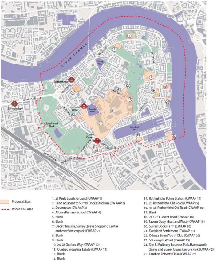
3.1 SITE LOCATION AND COMPOSITION
3.1.1 The Site is located in the Canada Water Opportunity Area and Housing Zone, within
Southwark, and its location is shown on Figure 3.1. The Opportunity Area covers much
of the Rotherhithe Peninsula on the southern side of the River Thames. Canary Wharf
and the Isle of Dogs are located to the east on the opposite side of the river.
3.1.2 The 21.3-hectare site includes:
Surrey Quays Shopping Centre (SQSC);
The former Harmsworth Quays Printworks;
The Surrey Quays Leisure Park (SQLP) site;
The site at Roberts Close;
The former Dock Offices Courtyard; and
The former Rotherhithe Police Station.
Figure 3.1: Site location plan
3.1.3 The Surrey Quays Shopping Centre is located to the south east of Canada Water and is
approximately 275m walking distance from Canada Water station. It was built in the
Page 15Masterplan Transport Assessment
1980s and provides 34,754m2 Gross Internal Area (GIA) of retail space. The shopping
centre is anchored by a 10,308m2 GIA Tesco Extra food store and the upper level
primarily accommodates dining outlets.
3.1.4 The Printworks was formerly used to print the Daily Mail and Evening Standard
newspapers, prior to relocation of their printing facility to Thurrock in 2013. It occupies
the north-eastern portion of the Site and is approximately 325m walking distance from
Canada Water station. The site of the Printworks extends to 5.32 hectares and consists
of buildings, car parking and loading areas. The buildings on the site total 42,047m2
GIA. Recently the Printworks has operated as an event space with a capacity of 6,000
people.
3.1.5 Surrey Quays Leisure Park forms the eastern portion of the Site and is approximately
450m walking distance from Canada Water station. It currently provides 12,645m2 GIA
of leisure and dining space including a cinema, bingo hall and bowling alley and
restaurants such as Pizza Hut, Cafe East and Frankie & Benny’s.
3.1.6 Roberts Close is located at the north-eastern extent of the Site and is approximately
750m walking distance from Canada Water station. The 0.3-hectare site is currently
used as a temporary community garden and also provides construction access to the
adjacent London Square site. The site has a long history of vacancy; planning
permission was granted in 2001 to provide a security facility and parking for the nearby
Printworks site, but this was not implemented.
3.1.7 The Dock Offices are located at the north-western edge of the Site and are
approximately 150m walking distance from Canada Water station; they are Grade II
listed and provide office accommodation. The Dock Office buildings are outside the red
line boundary of the Site, but their associated car parking and landscaped areas are
included as the area known as the Dock Offices Courtyard.
3.1.8 The former Rotherhithe Police Station is at the north-west end of the Site and is
approximately 525m walking distance from Canada Water station. The site area is 0.18
hectares and accommodates a 1,046m2 GIA building and external car parking. The site
was used as an operational police station before its closure in June 2013.
3.2 SITE ACCESS
3.2.1 At present each of the distinct areas of the Site have their own access arrangements;
these are discussed in greater detail below.
3.2.2 The Surrey Quays Shopping Centre is accessed by the public on foot, bicycle and by
vehicle from Surrey Quays Road and Redriff Road via Deal Porters Way, a private road
which runs through the shopping centre car park. Servicing takes place in a dedicated
service yard on the north-eastern side of the shopping centre building and service
vehicles enter and exit via Surrey Quays Road.
3.2.3 The Printworks is a secure site and therefore access points are currently limited.
Pedestrians and vehicles can enter and exit the site via an access control point on
Surrey Quays Road. Vehicle access is also permitted via an access control point on
Quebec Way.
3.2.4 The Surrey Quays Leisure Park is highly accessible for those on foot, who can gain
access to the site from Surrey Quays Road, Redriff Road and Quebec Way. The public
Page 16Masterplan Transport Assessment
can also gain access to the site on bicycle and by vehicle from roundabouts on Surrey
Quays Road and Quebec Way. These two points are also used by servicing vehicles to
enter and exit the site.
3.2.5 The Dock Office is accessed on foot from Surrey Quays Road and by vehicle from Deal
Porters Way.
3.2.6 The former Rotherhithe Police Station is accessed from Lower Road, with pedestrian
access directly into the building and vehicle access via a crossover and private access
road to the car park at the rear.
3.3 ON-SITE PARKING
Bicycle Parking
3.3.1 Within and around the existing Site there are approximately 386 existing bicycle parking
spaces. They are allocated as follows:
Surrey Quays Shopping Centre – 66 spaces;
Printworks – 26 spaces (these are private and therefore not accessible to the
general public);
Surrey Quays Leisure Park – 34 spaces;
Northern footway of Surrey Quays Road outside Canada Water station – 80
spaces;
Southern footway of Surrey Quays Road outside Canada Water station – 54
spaces;
On the south-east corner of the Surrey Quays Road / Deal Porters Way junction –
108 spaces;
Surrey Quays Road / Lower Road junction – 8 spaces; and
Lower Road outside Surrey Quays station – 10 spaces.
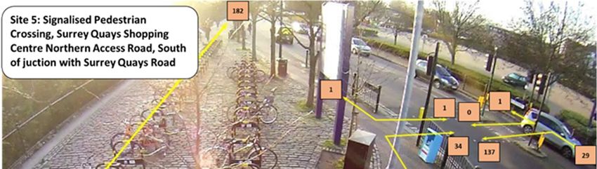
3.3.2 The locations of these spaces are shown on Figure 3.2 overleaf.
Page 17Masterplan Transport Assessment
Figure 3.2: Existing bicycle parking
3.3.3 In addition to this cycle parking provision, in March 2018 Mobike and ofo launched
‘dockless’ cycle hire schemes in Southwark, concentrating on the Rotherhithe and
Canada Water areas. In comparison to the traditional cycle hire model operated by TfL
where hire bikes are parked at fixed locations, dockless operators rely on existing public
cycle parking with bikes unlocked and hired via a phone app.
Motorcycle Parking
3.3.4 Surrey Quays Shopping Centre currently provides 18 off-street motorcycle parking
spaces. There are no further existing marked spaces across the Site.
Car Parking
3.3.5 The existing uses of the Site currently provide 2,216 off-street car parking spaces,
which are distributed as follows:
Surrey Quays Shopping Centre – 1,260 standard car parking spaces and 77
accessible car parking spaces (37 for disabled people and 40 parent and child), all
of which are available to the public;
Printworks – 270 standard car parking spaces and three spaces for disabled
people, although these are private car parking spaces and are not currently
available for use by the general public;
Page 18Masterplan Transport Assessment
Surrey Quays Leisure Park – 585 standard car parking spaces and 21 spaces for
disabled people, all of which are available to the public;
The Dock Offices – 32 car parking spaces (approximately, as the existing spaces
are poorly marked) which are private car parking spaces; and
Former Rotherhithe Police Station – 3 private car parking spaces (approximately).
3.4 COMMITTED DEVELOPMENT
3.4.1 Within the red line boundary, both the Surrey Quays Shopping Centre and the Surrey
Quays Leisure Park have previously been the subject of planning applications.
3.4.2 A planning permission was granted in March 2012 (reference 11/AP/4206) for a
10,500m2 retail extension to the Surrey Quays Shopping Centre. The planning
permission has been partially implemented and conditions discharged and therefore
could be fully built out despite the time that has elapsed since consent was granted.
3.4.3 Planning permission was granted in October 2010 (reference 90/AP/1999) for a
comprehensive redevelopment of the Surrey Quays Leisure Park to provide 1,800m2
retail, 890m2 restaurant use, 540 residential units, 123 student accommodation units
and a similar level of leisure provision as currently occupies the site. However, this
permission has not been implemented and has now expired.
3.4.4 Outside the red line boundary of the Site but in close proximity, the Decathlon site is
located to the north of the Surrey Quays Shopping Centre and to the west of the
Printworks, and has planning permission for 1,030 residential units, 12,301m2 of retail
space, 2,800m2 of offices, 698m2 of cinema space and 658m2 for a health centre. This
development is currently being constructed by Sellar Property Group and Notting Hill
Housing Trust.
3.4.5 The London Square site at 24-26 Quebec Way is located between the Printworks and
Roberts Close and has planning permission for 366 residential units and ancillary A1,
D1 and D2 uses. This site is currently under construction, and is due to complete in
2018.
3.4.6 The former Quebec Way Industrial Estate, to the east of the London Square site, is
being redeveloped as Quebec Quarter, providing 386 residential units, a creche and a
gym. Construction on the site is ongoing, with some units completed.
3.4.7 King’s College London is also in the process of developing the former Mulberry
Business Park site, immediately to the north-west of the Printworks. The completed
development will provide 770 new student rooms, office space, affordable housing,
retail units and a health care centre. Construction of the development is intended to be
complete in 2021.
3.5 EXISTING AND COMMITTED TRIP GENERATION
Surrey Quays Shopping Centre
3.5.1 The existing trip generation of the Surrey Quays Shopping Centre has been derived
from traffic surveys of the car park entrance carried out in December 2014. The number
of vehicle trips recorded as part of these surveys is shown in Table 3.1.
Page 19Masterplan Transport Assessment
Table 3.1: Surveyed weekday peak hour SQSC trips (December 2014)
AM Peak Hour PM Peak Hour
Arr Dep Arr Dep
Vehicles 279 228 498 520
3.5.2 The information from the 2014 surveys has been compared to car park data obtained
from British Land for the week commencing 4th September 2017, shown in Table 3.2.
This comparison showed that the 2014 survey data recorded a greater number of
movements into the car park than were recorded in 2017; as such, the use of December
2014 data is considered to be robust.
Table 3.2: SQSC car park arrivals, w/c 04/09/2017
AM peak hour PM peak hour
arrivals arrivals
04/09/2017 201 400
05/09/2017 197 387
06/09/2017 203 394
07/09/2017 229 383
08/09/2017 238 414
3.5.3 The Transport Assessment produced by Colin Buchanan and Partners for the 2012
planning permission (reference 11/AP/4206) to extend the shopping centre also set out
the mode share of existing shoppers. This is shown in Table 3.3.
Table 3.3: Surveyed SQSC mode share (taken from Colin Buchanan and Partners 2011 TA)
Mode Percentage
Car Drivers 38%
Car Passengers 2%
Motor bikes 0%
Bikes 1%
Bus 21%
LU / LO 10%
Train 0%
Walk 28%
Total 100%
3.5.4 Applying the mode shares in Table 3.2 to the number of car trips in Table 3.1, it is
possible to factor up car trips to work out the existing trips by all modes of transport as
shown in Table 3.4.
Page 20Masterplan Transport Assessment
Table 3.4: Baseline SQSC trips
AM peak hour PM peak hour
Arr Dep Arr Dep
Car Drivers 279 228 498 520
Car Passengers 15 12 26 27
Motor bikes 0 0 0 0
Bikes 7 6 13 14
Bus 154 126 275 287
LU / LO 73 60 131 137
Train 0 0 0 0
Walk 206 168 367 383
Total 734 600 1,311 1,368
3.5.5 As outlined in Section 3.4, there is also currently an extant planning permission to
extend the Surrey Quays Shopping Centre by 10,500m2, equivalent to a 35% increase
in floor area. Were the extant permission to be fully built out, this would result in the
total trip generation from the Surrey Quays Shopping Centre site shown in Table 3.5.
These trip numbers are taken from the Transport Assessment for the consented
development, on the basis that the increase in trips is not proportional to the increase in
floorspace.
Table 3.5: Consented SQSC trips
AM peak hour PM peak hour
Arr Dep Arr Dep
Car Drivers 310 254 554 578
Car Passengers 16 13 29 30
Motor bikes 0 0 0 0
Bikes 8 7 15 15
Bus 171 140 306 320
LU / LO 82 67 146 152
Train 0 0 0 0
Walk 229 187 408 426
Total 817 667 1458 1522
Surrey Quays Leisure Park
3.5.6 As with the Surrey Quays Shopping Centre, trip generation of the Surrey Quays Leisure
Park has been based on December 2014 traffic surveys, recording flows in and out of
the car park. This results in the number of vehicle trips shown in Table 3.6.
Page 21Masterplan Transport Assessment
Table 3.6: Surveyed SQLP trips
AM peak hour PM peak hour
Arr Dep Arr Dep
Vehicles 42 4 57 57
3.5.7 The Transport Assessment for the expired 2010 planning consent (reference
90/AP/1999) also set out the mode share of existing visitors as shown in Table 3.7.
Table 3.7: Surveyed SQLP mode share (taken from previous 2010 TA)
Mode Percentage
Car Drivers 40%
Car Passengers 10%
Motor bikes 0%
Bikes 0%
Bus 12%
LU / LO 11%
Train 0%
Walk 27%
Total 100%
3.5.8 Factoring up the car trips shown in Table 3.6 by the mode shares shown in Table 3.7
gives the total existing trip generation of the site shown in Table 3.8.
Table 3.8: Baseline SQLP trips
AM peak hour PM peak hour
Arr Dep Arr Dep
Car Drivers 42 4 57 57
Car Passengers 11 1 14 14
Motor bikes 0 0 0 0
Bikes 0 0 0 0
Bus 13 1 17 17
LU / LO 11 1 16 16
Train 0 0 0 0
Walk 28 3 38 38
Total 105 10 143 143
Former Harmsworth Quays Printworks
3.5.9 Although currently operating as an event space, the Harmsworth Quays Printworks site
could revert to its previous B1c / B2 use on expiry of the current temporary planning
consent. As such, the TRICS database has been used to determine the person trip
Page 22Masterplan Transport Assessment
rates for similar industrial units under a B2 use, shown in Table 3.9, and details of which
are presented in Appendix B.
Table 3.9: B8 Commercial Warehousing trip rates
AM peak hour PM peak hour
Arr Dep Arr Dep
2
Total People (trip rate / 100m GFA) 0.317 0.111 0.042 1.186
3.5.10 However, only one of the sites considered is based in London, and is in a location with
poorer access to public transport than the Site. As such, and given the absence of
survey data associated with the site’s previous use, 2011 Census Workplace data for
the Workplace Zones shown on Figure 3.3 and shown in Table 3.10 has been used to
split the person trip rates derived from TRICS into individual modes. The census data
used is shown in Appendix B. The resultant trips are shown in Table 3.11.
Figure 3.3: 2011 Census Workplace Zones
Page 23Masterplan Transport Assessment
Table 3.10: Journey to work mode share from 2011 census data
Mode Percentage
Car driver 34%
Car passenger 2%
Motorbike 2%
Bicycle 3%
Bus 18%
LU / LO 18%
Train 11%
Walk 13%
Total 100%
Table 3.11: Potential Harmsworth Quays Printworks trips
AM peak hour PM peak hour
Arr Dep Arr Dep
Car Drivers 45 16 6 170
Car Passengers 3 1 0 10
Motorbikes 3 1 0 10
Bicycle 4 1 1 15
Bus 24 8 3 90
LU / LO 24 8 3 90
Train 15 5 2 55
Walk 17 6 2 65
Total 135 47 18 504
Page 24Masterplan Transport Assessment
4. Canada Water Strategic Transport Study
4.1.1 In February 2017, TfL and Southwark Council commenced work on a Canada Water
Strategic Transport Study (STS) to examine the implications of growth in the Canada
Water Opportunity Area as a whole.
4.1.2 The STS examines future year conditions as if no development happened in the
Canada Water Opportunity Area and then explores how growth in the Opportunity Area
would change transport conditions. The STS aims to test and identify packages of
transport interventions that would be appropriate to address Opportunity Area growth, to
assist the authorities in setting future transport investment priorities for the area.
4.1.3 A range of discussions have taken place between TfL, Southwark Council and British
Land to agree how the STS can also inform the assessment of the Development that
British Land proposes. It has been agreed that this Transport Assessment can draw, as
appropriate, on work undertaken on the STS in order to ensure broad alignment and
consistency between the two studies. British Land has therefore been collaborating with
TfL and Southwark Council as the STS has developed.
4.1.4 The STS is underpinned by transport modelling using TfL’s strategic transport and land
use models, which are used as part of the evidence base for the London Plan and
Mayor’s Transport Strategy, as well as in developing Opportunity Areas across London.
For the STS, these comprise:
The London Transportation Studies (LTS) model, which uses the numbers of future
homes and jobs to forecast total trip volumes, where people will travel to and from,
and what mode of transport (public transport, highway or walking / cycling) they will
use. Outputs from the LTS model are translated into inputs into TfL’s two primary
assignment models, Railplan and CLoHAM.
The Railplan model, which assigns public transport trips from LTS onto the rail and
bus networks in the area, taking account of service levels and journey times to
determine the number of trips likely to be seen on each part of the public transport
network.
The Central London Highway Assignment Model (CLoHAM), based on SATURN
software, which assigns highway-based trips from LTS onto the highway network.
Again, CLoHAM takes account of highway network conditions and journey times to
determine the most likely route taken between an origin and a destination.
4.1.5 TfL’s strategic models draw on predicted growth in population and jobs from the 2016
London Plan. The models have a base year of 2011 for public transport and 2012 for
highways. Future years of 2021, 2031 and 2041 are used to align with London Plan
growth projections, which underpin the modelling. 2031 is being used as the basis for
the work in this Transport Assessment, as this is closest to the 2033 completion date
assumed for the Development and used for assessment in the Environmental
Statement.
4.1.6 The STS explores two scenarios for 2031:
a ‘Do Minimum’ scenario which assumes no additional development in the
Opportunity Area (but assumes London Plan growth forecasts are achieved
Page 25Masterplan Transport Assessment
elsewhere). This represents the ‘future baseline’ for this Transport Assessment, i.e.
the future conditions if no development was brought forward within the Canada
Water Opportunity Area;
a ‘Do Something’ scenario which includes new development in the Opportunity Area
including the developments proposed by British Land, Notting Hill Housing / Sellar
and Kings.
4.1.7 TfL’s specification for the STS covers public transport modelling for the three-hour
morning peak period from 0700 to 1000 hours and highway modelling for the one-hour
evening peak period from 1700 to 1800 hours, which has been agreed to be the worst
case in each instance.
4.1.8 As part of early work within the STS, TfL and Southwark Council agreed to work with
British Land and Arup to share the LTS forecasts for the 2031 ‘Do Minimum’ scenario
and to create LTS forecasts for the two Development Scenarios which are being
proposed by British Land. This information has been used in this Transport Assessment
where appropriate so that there is a common basis with the STS and therefore the
London Plan, and has been developed further as part of this assessment as necessary.
Page 26You can also read