Land West of Imberhorne Lane, East Grinstead Heritage Statement June 2020 - Mid Sussex District Council
←
→
Page content transcription
If your browser does not render page correctly, please read the page content below
Land West of Imberhorne Lane, East Grinstead Heritage Statement June 2020
Land West of Imberhorne Lane, East Grinstead
Heritage Statement
June 2020

© Orion Heritage Ltd 2020

No part of this report is to be copied in any way
without prior written consent.

Every effort is made to provide detailed and accurate
information, however, Orion Heritage Ltd cannot be held
responsible for errors or inaccuracies of 3rd party data
supplied to Orion and used within this report.

© Ordnance Survey maps reproduced with the
sanction of the controller of HM Stationery Office.

Licence No: 100056706
i                   Report
                    Heritage Statement

                    Site
                    Land West of Imberhorne Lane
                    East Grinstead

                    Client
                    Welbeck Strategic Land

                    Planning Authority
                    Mid-Sussex District Council

                    Grid reference
                    TQ 37198 38672

                    Prepared By
                    Jan Mathieson BA(Hons) BArch ARB RIBA AABC

                    Reviewed By
                    Rob Bourn BA MA MCIfA

                    Report Status
                    Approved

                    Date
                    29/06/2020

                    Orion Ref
                    PN1099/HS/1

Land west of
Imberhorne Lane
East Grinstead  June 2020
ii                  Contents

                    Executive Summary
                    1.0        Introduction

                    2.0        Planning Background and Development Plan Framework

                    3.0        Historical Context and Location of Heritage Assets

                    4.0        Proposed Development and Potential Impact on Heritage Assets

                    5.0        Summary and Conclusions

                    Sources Consulted

                    Appendix 1: Historic England Listing of Buildings

                    List of Illustrations
                    Figure 1     Site Location
                    Figure 2     Location of Listed Buildings in vicinity
                    Figure 3     Tithe map of 1842
                    Figure 4     Ordnance Survey Map of 1878-79
                    Figure 5     Ordnance Survey Map of 1899
                    Figure 6     Ordnance Survey Map of 1911-13
                    Figure 7     Aerial Survey of 1947
                    Figure 8     Ordnance Survey Map of 1963
                    Figure 9     Ordnance Survey Map of 1978
                    Figure 10 Ordnance Survey Map of 1999
                    Figure 11 Design Concept

                    List of Plates
                    Plate 1      Ordnance Survey Map First Series of 1846
                    Plate 2      Imberhorne Farm Cottages - carved timber detail
                    Plate 3      Elevation of 1 – 3 Imberhorne Farm Cottages
                    Plate 4      Front elevation to Gulledge (archive photograph)
                    Plate 5      Gulledge side (west) elevation
                    Plate 6      Imberhorne Farmhouse – elevation from south-east
                    Plate 7      Gulledge – view from north
                    Plate 8      Imberhorne Farmhouse North (front) elevation

Land west of
Imberhorne Lane
East Grinstead  June 2020
iii                 Executive Summary

                    This heritage statement considers land at Imberhorne Farm, East Grinstead (the Study
                    Site) and the potential impact of the proposed development upon the significance of
                    those designated and non-designated heritage assets located in its vicinity, together with
                    impact upon the significance of the heritage assets by development within their setting.

                    In accordance with Paragraph 189 of the National Planning Policy Framework (NPPF
                    2018) and Local Plan policies this report first identifies and describes the historical
                    development of the subject site and outlines the significance of the designated and non-
                    designated heritage assets before going on to consider the impact of the proposal on that
                    significance.

                    There are no designated heritage assets within the redline of the site. There are a
                    number of listed buildings located in the vicinity of the site. Those in closest proximity,
                    which have the potential to be impacted by the proposals, are Imberhorne Farmhouse
                    (grade II), 1 - 3 Imberhorne Farm Cottages (grade II*) and Gulledge Farmhouse (grade
                    II*). This is as a result of the buildings being good examples of their type and of the
                    connections with the Manor of Imberhorne. In particular, remnants of the Medieval
                    building are set within the fabric of 1 – 3 Imberhorne Farm Cottages.

                    The significance of all heritage assets was assessed, by considering the archaeological,
                    artistic, architectural and historic values. It was found that these values were not harmed
                    by the proposals. The setting of each building was then considered, to determine if the
                    significance of the heritage assets was impacted by development within their setting. It
                    was found that there was no impact due to co-visibility as a result of distance and
                    screening. It was, however, considered that the non-visual attributes of purpose,
                    economy and function were impacted by the loss of the agricultural fields which were
                    once associated with the heritage assets. However, as this was only part of their
                    significance, it was assessed to cause a low level of less than substantial harm to the
                    heritage assets. It was therefore concluded that the proposals comply with the relevant
                    heritage paragraphs contained in Section 16 of the NPPF 2018 and relevant local
                    heritage policy.

Land west of
Imberhorne Lane
East Grinstead  June 2020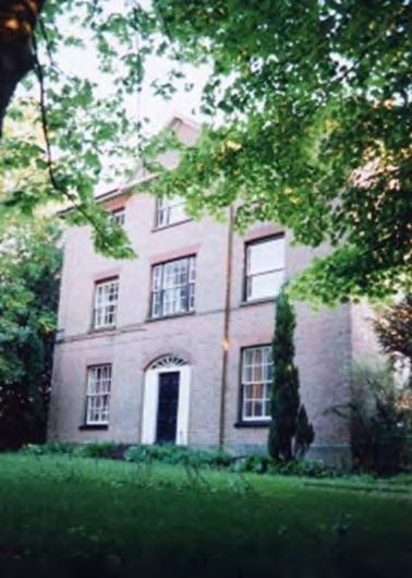
i                   1.0 Introduction
                    1.1     This heritage statement considers Land West of Imberhorne Lane, East Grinstead
                            (Figure 1). The site (hereinafter referred to as the “Study Site”) is located at grid
                            reference TQ 37198 38672.

                    1.2     In accordance with the Paragraph 189 of the National Planning Policy Framework
                            (NPPF 2018) and the requirement for applicants to describe the significance of
                            heritage assets including contribution to setting, the report draws together available
                            information on designated and non-designated heritage assets.

                    1.3     The assessment includes the results of a site inspection, an examination of
                            published and unpublished records, charts historic land-use through a map
                            regression exercise and considers relevant national and local policy and guidance.

                    1.4     The Historic Environment Record and Historic England Schedule of Listed
                            Buildings has been consulted (online) and the relevant designated and non-
                            designated heritage assets located in the immediate vicinity are identified in Figure
                            2.

                    1.5     A site visit was undertaken in November 2019 when the conditions were overcast
                            but visibility was good. However, no access was possible either inside the heritage
                            assets but, as the nature of the issues are likely to be related primarily to setting,
                            this was not considered to affect the assessment.

                    1.6     The development is residential, located as indicated in Figure 11. Features include
                            enhancement of facilities at an existing school located on site, play areas,
                            allotments, a care community and local centre.

                    1.7     Land west of Imberhorne Lane is allocated at Policy SA 20 of the emerging Mid
                            Sussex Site Allocations DPD (Regulation 19) for c550 dwellings, care village (use
                            class C2), local centre, 2FE primary school (and early years provision), strategic
                            SANG, playing fields for Imberhorne Secondary School and associated open
                            space.

                    1.8     There has been a number of iterations of the masterplan for the scheme in the last
                            3 years, all of which have taken the heritage issues for the site into account.
                            During this time the heritage aspects of the scheme have been a core design
                            issue. Consultations with the Mid-Sussex Conservation Officer and with the
                            Historic England Inspector of Historic Buildings and Areas and their comments and
                            observations have been taken into account in following iterations of the scheme to
                            remove or significantly reduce the potential impact on significance of designated
                            heritage assets and leading to the layout as shown in Figure 11. It is this last
                            iteration of the masterplan that this document assesses. This masterplan includes
                            various previous inbuilt design measures to reduce the effect on designated
                            heritage assets.

                            Location and Description

                    1.9     The Study Site is located at Imberhorne Farm, Imberhorne Lane, East Grinstead.
                            The land-use in the wider area was historically agricultural land (Figures 3 - 6), but
                            this has slowly been replaced to the north and east by housing and ancillary
                            service buildings, with an industrial-type complex immediately to the north east.
                            Fields and wooded areas act as buffers between the Study Site and these zones.

                    1.10    To the east lies East Grinstead, its western boundary running along the east side of
                            Imberhorne Lane to the east of the site. This development takes the form of
                            detached or semi-detached low-rise residences constructed at various times during
                            the mid- to late- 20th century.

Land west of
Imberhorne Lane
East Grinstead  June 2020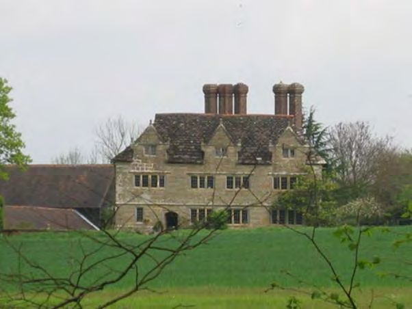
ii                  1.11    This style of development continues in the area of Felbridge around to the north,
                            although development density is lower. The nearest road to the north of the Study
                            Site is Crawley Down Road which then turns south to become the nearest road to
                            the west of the site, where it is then named Hophurst Hill. The nearest road to the
                            east of the site is Imberhorne Lane with London Road running diagonally to the
                            north-east.

                    1.12    The Birches Industrial Estate to the north-east (which replaced part of a wood of
                            the same name) includes several technical and construction suppliers. It comprises
                            large industrial-style structures and associated car parks, the largest building
                            being, apart from the designated heritage assets, the closest built form in proximity
                            to the Study Site.

                    1.13    Either wooded or grassed areas act as buffer zones between the Study Site and
                            these later developments. Wooded or grassed areas are also located to the south
                            and west with built development some further way off.

                    1.14    There are three designated heritage assets which are in sufficient proximity to, but
                            not on, the site to have the potential for the development to impact their
                            significance. This includes impact to this significance by development in their
                            setting. There are no other heritage assets, either designated or non-designated, in
                            close proximity, nor is the Study Site within a conservation area, the nearest one
                            being in East Grinstead at some distance to the east.

                    1.15    This report considers impact of development on the Study Site on the significance
                            of heritage assets at Imberhorne Farmhouse, Imberhorne Farm Cottages and
                            Gulledge Farm.

Land west of
Imberhorne Lane
East Grinstead  June 2020
iii 2.0 Planning Background and Development Plan Framework
Planning (Listed Building and Conservation Areas) Act 1990
2.1 The Planning (Listed Building and Conservation Areas) Act 1990 sets out broad
policies and obligations relevant to the protection of Listed Buildings and
Conservation Areas and their settings.
2.2 Section 66(1) states:
In considering whether to grant planning permission for development which affects
a listed building or its setting, the local planning authority or, as the case may be,
the Secretary of State shall have special regard to the desirability of preserving the
building or its setting or any features of special architectural or historic interest
which it possesses.
2.3 Section 69 of the Act requires local authorities to define as conservation areas any
areas of special architectural or historic interest the character or appearance of
which it is desirable to preserve or enhance and Section 72 gives local authorities a
general duty to pay special attention to the desirability of preserving or enhancing
the character or appearance of that area in exercising their planning functions.
These duties are taken to apply only within a Conservation Area. The Act does not
make specific provision with regard to the setting of a Conservation Area, that is
provided by the policy framework outlined below.
National Planning Policy Framework (NPPF) and National Planning Practice
Guidance (NPPG)
2.4 Government policy in relation to the historic environment is outlined in Section 16
of the National Planning Policy Framework 2018 (NPPF), entitled Conserving and
Enhancing the Historic Environment. This provides guidance for planning
authorities, property owners, developers and others on the conservation and
investigation of heritage assets. Overall, the objectives of Section 16 of the NPPF
can be summarised as seeking the:
• Delivery of sustainable development;
• understanding the wider social, cultural, economic and environmental
benefits brought by the conservation of the historic environment;
• conservation of England's heritage assets in a manner appropriate to their
significance; and
• recognition of the contribution that heritage assets make to our knowledge
and understanding of the past.
2.5 Section 16 of the NPPF recognises that intelligently managed change may
sometimes be necessary if heritage assets are to be maintained for the long term.
2.6 Paragraph 189 states that planning decisions should be based on the significance
of the heritage asset, and that the level of detail supplied by an applicant should be
proportionate to the importance of the asset, and should be no more than sufficient
to understand the potential impact of the proposal upon the significance of that
asset.
2.7 Heritage Assets are defined in Annex 2 as a building, monument, site, place, area
or landscape identified as having a degree of significance meriting consideration in
planning decisions, because of its heritage interest. Heritage assets include
designated heritage assets and assets identified by the local planning authority
(including local listing).
Land west of
Imberhorne Lane
East Grinstead June 2020iv 2.8 Designated Heritage Assets comprise: World Heritage Sites, Scheduled
Monuments, Listed Buildings, Protected Wreck Sites, Registered Parks and
Gardens, Registered Battlefields and Conservation Areas.
2.9 Significance is defined as: the value of a heritage asset to this and future
generations because of its heritage interest. This interest may be archaeological,
architectural, artistic or historic. Significance derives not only from a heritage
asset’s physical presence, but also from its setting.
2.10 Setting is defined as: the surroundings in which a heritage asset is experienced. Its
extent is not fixed and may change as the asset and its surroundings evolve.
Elements of a setting may make a positive or negative contribution to the
significance of an asset, may affect the ability to appreciate that significance or
may be neutral.
2.11 The NPPF is supported by the National Planning Policy Guidance (NPPG). In
relation to the historic environment, paragraph 18a-001 states that:
Protecting and enhancing the historic environment is an important component of
the National Planning Policy Framework’s drive to achieve sustainable
development (as defined in Paragraphs 6-10). The appropriate conservation of
heritage assets forms one of the ‘Core Planning Principles’.
2.12 Paragraph 18a-002 makes a clear statement that any decisions relating to Listed
Buildings and their settings and Conservation Areas must address the statutory
considerations of the Planning (Listed Buildings and Conservation Areas) Act
1990, as well as satisfying the relevant policies within the National Planning Policy
Framework and the Local Plan.
2.13 Paragraph 18a-013 outlines that the assessment of the impact of a proposed
development on the setting of a heritage asset needs to take into account and be
proportionate to the significance of the asset being considered, and the degree to
which the proposed development enhances or detracts from the significance of the
asset and the ability to appreciate the significance.
2.14 The NPPG outlines that although the extent and importance of setting is often
expressed in visual terms, it can also be influenced by other factors such as noise,
dust and vibration. Historic relationships between places can also be an important
factor stressing ties between places that may have limited or no intervisibility with
each other. This may be historic as well as aesthetic connections that contribute or
enhance the significance of one or more of the heritage assets.
2.15 Paragraph 18a-013 concludes:
The contribution that setting makes to the significance of the heritage asset does
not depend on there being public rights or an ability to access or experience that
setting. This will vary over time and according to circumstance. When assessing
any application for development which may affect the setting of a heritage asset,
local planning authorities may need to consider the implications of cumulative
change. They may also need to consider the fact that developments which
materially detract from the asset’s significance may also damage its economic
viability now, or in the future, thereby threatening its on-going conservation.
2.16 The key test in NPPF paragraphs 193-196 is whether a proposed development will
result in substantial harm or less than substantial harm. However, substantial harm
is not defined in the NPPF. Paragraph 18a-017 of the NPPG provides additional
guidance on substantial harm. It states:
What matters in assessing if a proposal causes substantial harm is the impact on
the significance of the heritage asset. As the National Planning Policy Framework
Land west of
Imberhorne Lane
East Grinstead June 2020v makes clear, significance derives not only from a heritage asset’s physical
presence, but also from its setting. Whether a proposal causes substantial harm
will be a judgment for the decision taker, having regard to the circumstances of the
case and the policy in the National Planning Policy Framework. In general terms,
substantial harm is a high test, so it may not arise in many cases. For example, in
determining whether works to a listed building constitute substantial harm, an
important consideration would be whether the adverse impact seriously affects a
key element of its special architectural or historic interest. It is the degree of harm
to the asset’s significance rather than the scale of the development that is to be
assessed.
2.17 Paragraph 196 of the NPPF outlines that where a proposed development results in
less than substantial harm to the significance of a heritage asset, the harm arising
should be weighed against the public benefits accruing from the proposed
development. Paragraph 18a-020 of the NPPG outlines what is meant by public
benefits:
Public benefits may follow from many developments and could be anything that
delivers economic, social or environmental progress as described in the National
Planning Policy Framework (Paragraph 7). Public benefits should flow from the
proposed development. They should be of a nature or scale to be of benefit to the
public at large and should not just be a private benefit. However, benefits do not
always have to be visible or accessible to the public in order to be genuine public
benefits.
2.18 Paragraph 197 states:
the effect of an application on the significance of a non-designated heritage asset
should be taken into account in determining the application. In weighing
applications that affect directly or indirectly non-designated heritage assets, a
balanced judgement will be required having regard to the scale of any harm or loss
and the significance of the heritage asset.
Local Planning Policy
2.19 The Mid Sussex District Plan 2014 – 2031, Adopted March 2018 is the relevant
local plan and DP34: Listed Buildings and Other Heritage Assets is the section
which sets out the requirements in relation to Listed Buildings.
2.20 The Strategic Objectives are;
• To promote well located and designed development that reflects the District’s
distinctive towns and villages, retains their separate identity and character and
prevents coalescence
• To protect valued characteristics of the built environment for their historical
and visual qualities; and
• To support and enhance the attractiveness of Mid Sussex as a visitor
destination.
2.21 The Evidence Base is the West Sussex Historic Environment Record; Register of
Listed Buildings.
2.22 In connection with Listed Buildings, the policy states that ‘Development will be
required to protect listed buildings and their settings. This will be achieved by
ensuring that:
• A thorough understanding of the significance of the listed building and its
setting has been demonstrated. This will be proportionate to the importance of
the building and potential impact of the proposal;
• Alterations or extensions to a listed building respect its historic form, scale,
setting,
Land west of
Imberhorne Lane
East Grinstead June 2020vi significance and fabric. Proposals for the conversion or change of use of a
listed building retain its significance and character whilst ensuring that the
building remains in a viable use;
• Traditional building materials and construction techniques are normally used.
The installation of uPVC windows and doors will not be acceptable;
• Satellite antennae, solar panels or other renewable energy installations are
not sited in a prominent location, and where possible within the curtilage
rather than on the building itself; Special regard is given to protecting the
setting of a listed building;
• Where the historic fabric of a building may be affected by alterations or other
proposals, the applicant is expected to fund the recording or exploratory
opening up of historic fabric.
.
2.23 The Plan further notes that ‘The Council will seek to conserve heritage assets in a
manner appropriate to their significance, so that they can be enjoyed for their
contribution to the character and quality of life of the District. Significance can be
defined as the special interest of a heritage asset, which may be archaeological,
architectural, artistic or historic.
Proposals affecting such heritage assets will be considered in accordance with the
policies in the National Planning Policy Framework (NPPF) and current
Government guidance’.
Other Guidance
Historic Environment Good Practice Advice In Planning Note 2: Managing
Significance in Decision-Taking in the Historic Environment (Historic England
2015)
2.24 The purpose of this document is to provide information to assist local authorities,
planning and other consultants, owners, applicants and other interested parties in
implementing historic environment policy in the NPPF and NPPG. It outlines a six-
stage process to the assembly and analysis of relevant information relating to
heritage assets potentially affected by a proposed development:
• Understand the significance of the affected assets;
• Understand the impact of the proposal on that significance;
• Avoid, minimise and mitigate impact in a way that meets the objectives of the
NPPF;
• Look for opportunities to better reveal or enhance significance;
• Justify any harmful impacts in terms of the sustainable development
objective of conserving significance and the need for change; and
• Offset negative impacts on aspects of significance by enhancing others
through recording, disseminating and archiving archaeological and historical
interest of the important elements of the heritage assets affected.
Historic Environment Good Practice Advice In Planning Note 3: The Setting of
Heritage Assets (Historic England 2017)
2.25 Historic England’s Historic Environment Good Practice Advice in Planning Note 3
provides guidance on the management of change within the setting of heritage
assets.
2.26 The document restates the definition of setting as outlined in Annex 2 of the NPPF.
Setting is also described as being a separate term to curtilage, character and
context; while it is largely a visual term, setting, and thus the way in which an asset
is experienced, can also be affected by noise, vibration, odour and other factors.
The document makes it clear that setting is not a heritage asset, nor is it a heritage
designation, though land within a setting may itself be designated. Its importance
lies in what the setting contributes to the significance of a heritage asset.
Land west of
Imberhorne Lane
East Grinstead June 2020vii
2.27 The Good Practice Advice Note sets out a five-stage process for assessing the
implications of proposed developments on setting:
1. Identification of heritage assets which are likely to be affected by proposals;
2. Assessment of whether and what contribution the setting makes to the
significance of a heritage asset;
3. Assessing the effects of proposed development on the significance of a
heritage asset;
4. Maximising enhancement and reduction of harm on the setting of heritage
assets; and
5. Making and documenting the decision and monitoring outcomes
2.28 The guidance reiterates the NPPF in stating that where developments affecting the
setting of heritage assets results in a level of harm to significance, this harm,
whether substantial or less than substantial, should be weighed against the public
benefits of the scheme.
Historic England 2019 Statement of Heritage Significance: Analysing Significance
in Heritage Assets Historic England Advice Note 12.
2.29 The purpose of this guidance is ‘to provide information on the analysis and
assessment of heritage significance in line with the National Planning Policy
Framework (NPPF) to assist owners, applicants, local planning authorities (LPAs),
planning and other consultants, and other interested parties in implementing
historic environment legislation, the policy in the NPPF and the related guidance
given in the Planning Practice Guidance (PPG)’.
2.30 It sets out the principles of significance as ‘Significance is one of the guiding
principles running through the historic environment section of the NPPF. The NPPF
defines significance as ‘the value of a heritage asset to this and future generations
because of its heritage interest’.
2.31 Section 2 defines the categories under which significance ought to be assessed
thus ‘Such interest may be archaeological, architectural, artistic or historic’ and it
may derive ‘not only from a heritage asset’s physical presence, but also from its
setting’ Significance is what conservation sustains, and where appropriate
enhances, in managing change to heritage assets’.
2.32 Archaeological interest; There will be archaeological interest in a heritage asset if
it
holds, or potentially holds, evidence of past human activity worthy of expert
investigation at some point.
2.33 Architectural and artistic interest; These are interests in the design and general
aesthetics of a place. They can arise from conscious design or fortuitously from the
way the heritage asset has evolved.
2.34 More specifically, architectural interest is an interest in the art or science of the
design, construction, craftsmanship and decoration of buildings and structures of
all types. Artistic interest is an interest in other human creative skills, like sculpture.
2.35 Historic Interest; An interest in past lives and events (including pre-historic).
Heritage assets can illustrate or be associated with them. Heritage assets with
historic interest not only provide a material record of our nation’s history but can
also provide meaning for communities derived from their collective experience of a
place and can symbolise wider values such as faith and cultural identity. Having
described the various interests, assess the level of the general significance of the
heritage asset and the particular contribution to that significance of any features
Land west of
Imberhorne Lane
East Grinstead June 2020viii which would be affected by the proposal, or of its setting if it, too, is affected by the
proposal.
2.36 Section 3 further notes in particular relation to setting that ‘Where the proposal
affects the setting, and related views, of a heritage asset, or assets, clarify the
contribution of the setting to the significance of the asset, or the way that the
setting allows the significance to be appreciated. This may include the impact of
the location of new development within the setting, of the impact on key views, the
impact on the relationship of the heritage asset to its
setting, etc.’.
Land west of
Imberhorne Lane
East Grinstead June 2020ix 3.0 Historical Context and Location of Heritage Assets
Introduction
3.1 The following section presents a historical development of the site and wider area
through the results of a map regression exercise and review of relevant
background documentation.
3.2 The location of designated heritage assets surrounding the site are also discussed
below; these are shown on Figure 2. There are no heritage assets on the Study
Site itself.
Historical Background
The Local Area
3.3 The Study Site sits in an area which was primarily rural, witnessed by the fact that
the name of East Grinstead, the nearest sizeable settlement to the Study Site,
which meant ‘green place’. It was originally a Saxon village which, by the time of
the Domesday Book in 1086 had grown to be a significant settlement for the
period.
3.4 By the 13th century, East Grinstead was granted town status and, in 1247, the town
was given a charter which conferred advantageous rights. These included the right
to hold weekly markets together with an annual fair which, by 1516, had been
increased to two fairs each year.
3.5 In medieval times, the population numbered just a few hundred, but East Grinstead
was growing in status. The increased number of fairs bought in many people from
the local area which enhanced its prosperity and from early in the 14th century to
the mid-18th century, the town provided MPs to represent its interests.
3.6 An important feature in the development of East Grinstead was that it was on the
main road from London to Lewes, which is the county town of Sussex. The journey
from London to Lewes was too arduous to complete without a break, it was
preferable to stop overnight, the most convenient place being East Grinstead.
3.7 By the mid-18th century, the popularity of Brighton as a seaside resort, being much
enhanced by Royal patronage, significantly increased the number of stagecoaches
passing through. Accordingly, the number of inns and other necessary services for
the traveller, grew, thereby increasing prosperity. A small indicator of this prosperity
is that the high street has the longest run of medieval timber buildings which have
remained in continuous commercial use in the country.
3.8 The population of East Grinstead increased significantly during the early 19th
century. By the end of the century it had reached 6,000. Improvements during the
19th century included its acquisition of a railway station, resulting in the end of
stagecoach travel but allowing commuting to and from the town, as a result of
which the population grew rapidly. Other benefits were gas light, sewers, piped
water and a cemetery – all mundane but essential facilities required by a growing
Victorian town of some quality. Following World War II, the council built more
houses and many private houses were also developed.
3.9 Commercial and industrial facilities were enhanced in the 20th century. This
development of the central area of East Grinstead is not within proximity of the
Study Site. However, residential areas beyond wooded and grassed areas to the
north and east, and a commercial and industrial zone to the north east, are the
furthest outposts of East Grinstead’s development.
Land west of
Imberhorne Lane
East Grinstead June 2020x The Study Site (histories of individual buildings are detailed later in this section)
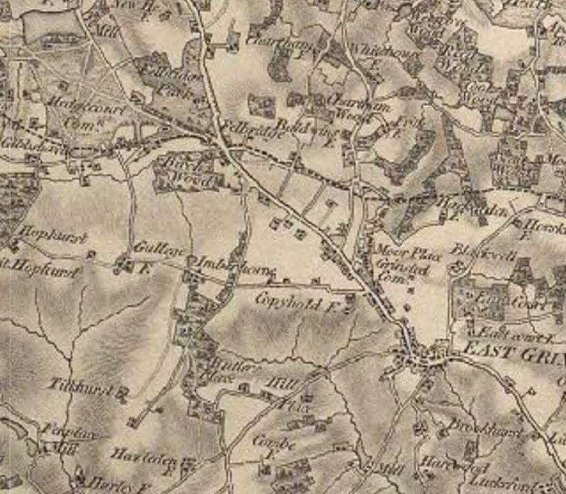
3.10 Historic maps, including the first Ordnance Survey Series of 1806 (Plate 1),
Illustrate the development of East Grinstead stringing out along the London Road
running diagonally to the north east of the Study Site, which can be identified by
the noting of the locations of Imberhorne and Gulledge.
Plate 1 Ordnance Survey Map First Series of 1846
3.11 One of the first references to Imberhorne itself was in about 1100AD when land
was given to Lewes Priory by a William Malfield.
3.12 The Priory continued to amass land in the area which increase the size of this
holding until, by 1275AD, it had become the Manor of Imberhorne. Its location,
approximately halfway between London and Lewes, suggest selection of this site
by the Priory for construction of The Manor House may have been to provide rest
during the journey between London and Lewes for those involved with the Order.
3.13 The Manor of Imberholme was in the ownership of various eminent families,
including Thomas Cromwell, the Sitwell family (owners of Knole) and The Blount
family. It was also returned to The Crown several times during its history.
3.14 The Study Site is thus established as retaining its agricultural nature, but possibly
benefiting from the prosperity of nearby East Grinstead and certainly from its
convenient location on the main route between London and Lewes.
3.15 The Study Site is shown on the historic maps (Figures 3 - 6) as fields divided by
planted boundaries, the designated heritage assets of Imberhorne Farmhouse,
Imberhorne Farm Cottages sitting to the east and Gulledge Farm to the west of the
access route and bridleway on the southern boundary of the Study Site.
Designated Heritage Assets
Land west of
Imberhorne Lane
East Grinstead June 2020xi 3.16 Whilst there are no heritage assets on the Study Site, there are three designated
heritage assets – Imberhorne Farm, Imberhorne Farm Cottages and Gulledge
Farm, all in close proximity. There are no non-designated heritage assets in
proximity and the East Grinstead Conservation Area is far enough to the east so as
not to be impacted by the development. This section sets out only a brief history of
the assets, the detail and significance of which is discussed further in Section 4.
Imberhorne Farmhouse - Grade ll
3.17 Imberhorne Farmhouse is to the south-east corner of the Study Site and is Listed
Grade ll. It sits in a grouping with Imberhorne Farm Cottages, together with several
other agricultural buildings including stables and storage facilities.
3.18 Imberhorne Farmhouse (Plate 2) is a Georgian brick-built house, dated to the early
19th century, which sits on a stone base and has a slate roof. It has substantial
accommodation, including several bedrooms, entrance hall, sitting room, kitchen
with larder, scullery, cellar, dairy and associated ancillary rooms.
3.19 In 1560, the estate was bought by Sir John Sackville in whose family it remained
until 1872, although the Sackvilles are thought never to have resided there, their
primary residence being at Knole. It is therefore likely that the farmhouse was
constructed during their stewardship in 1820.
3.20 By 1955, all of the relevant heritage assets were in the stewardship of a single
owner when the Emmett family bought the farms of Imberhorne and Gulledge.
3.21 The Farmhouse sits, as historic maps suggest it has always done, with a group of
ancillary agricultural building to its west and south-west. This group appears to
have evolved over time, but today comprises storage and farm buildings to the
west, with Imberhorne Farm Cottages and agricultural buildings to the south-west.
3.22 Historic plan also suggest that the Farmhouse had orchards to the east, and
possibly a kitchen garden to south. Mature trees, many of which possibly remain
today, providing landscaped grounds in the immediate vicinity of the building.
Plate 2 Imberhorne Farmhouse North (front) elevation (archive photograph)
Land west of
Imberhorne Lane
East Grinstead June 2020xii
1 – 3 Imberhorne Farm Cottages Grade ll*
3.23 1–3 Imberhorne Farm Cottages appear to be, when viewed from the exterior,
Victorian farm-workers' cottages (Plate 3). This outward impression masks the
building’s origins in the early 15th century, when the original building, over which
the veneer of the cottages is laid, was part of The Manor House of Imberhorne.
Plate 3 Elevation of 1 – 3 Imberhorne Farm Cottages
3.24 It is likely that one of the primary reasons that the Manor of Imberhorne was
located there was as a location to break the journey between London and Lewes
as it is positioned on the main London Road, and appears to have been of
considerable quality to impress visitors.
3.25 Within the external Victorian brick skin, lies the remnants an early arch-braced
false hammer-beam roof of The Manor. Research (by others) could not provide a
date of construction, but the timber has been tree-ring dated to 1428. The structure
is compared to other surviving arch-braced examples. It is not dissimilar in
structural concept to the design of Westminster Hall but lacks the latter’s level of
elaborate decoration (Plate 3).
Land west of
Imberhorne Lane
East Grinstead June 2020xiii
Plate 4 Imberhorne Farm Cottages - carved timber detail to roof structure (archive photo)
3.26 The structure of the building has been extensively researched, recorded and
documented, such is its pre-eminence as an example of this type of timber
construction. Historic England’s Listing, together with several additional
publications, have analysed the interior in detail. However, this Heritage Statement
does not impact the interior so no detail concerning the interior entered into.
Historic England’s Listing in Appendix 1 gives further detail.
Gulledge Farmhouse Grade ll*
3.27 Gulledge Farmhouse is situated at the end of the long lane and bridlepath, leading
west from Imberhorne Lane and passing to the north of Imberhorne Farmhouse
and Farm Cottages. The origins of the house lie in Tudor times, around 1550, when
the building was first constructed as a timber framed property, remnants of which
remain to the side (east and west) elevations (Plate 5).
Plate 5 Front elevation to Gulledge (archive photograph)
Land west of
Imberhorne Lane
East Grinstead June 2020xiv 3.28 The fact that the timber framing is closer than might be required for constructional
purpose defines it as a house of some quality (Plate 6). It is certainly larger than
most Wealden properties, which were generally noted for their small size. The
chimney location indicates that the house was once T-shaped, possibly with a hall
and a gallery. Later Horsham stone slabs are laid on the roof which is supported on
heavy beams.
3.29 In 1609, a three-gabled Jacobean front with mullion windows replaced the earlier
exterior (Plate 5). With the Tudor chimneys still in situ, this presents an imposing
façade. However, it is clear that this was intended primarily to impress, as the
façade does not extend around the side elevations and the interior was not
upgraded, at that time, to this standard. The stone for the facade is thought to have
been quarried locally, and the resulting excavations turned into a pond.
3.30 Records suggest that Richard Alfrey, MP for East Grinstead, lived at Gulledge in
1365. His descendant, Edward Alfrey, most likely added the stone facade and
family crest in the 16th century. Mid-16th century wall paintings were uncovered
during recent restoration.
3.31 A further extension was added to the rear (north) elevation, but this was of lesser
quality, apparently being constructed from reused materials. However, it does not
detract from the imposing façade; the agglomeration of materials and styles
presents an interesting layering of the evolution of the building.
3.32 Historic maps suggest that the farm has invariably had a selection of ancillary
buildings over time. As these will most likely have been not of the highest quality,
they have not survived in their entirely and today, a range of buildings stands to the
north-west of Gulledge farmhouse, with a wooded and planted area to the north-
east.
Plate 6 Gulledge side (west) elevation illustrating remaining elements of earlier construction
Land west of
Imberhorne Lane
East Grinstead June 2020xv
4.0 Proposed Development and Potential Impact on Heritage Assets
Background
4.1 This section identifies and assesses the impacts of the proposal on the significance
of the heritage assets located within and in the vicinity of the subject site. In
assessing the heritage impacts of the proposal, the relevant policies cited in
section 2.0 have been referenced.
The Proposed Development
4.2 The proposed development comprises residential units located on the Study Site
(Figure 11). They include a Care Community, enhancements to an existing school,
allotments, a local centre and play areas.
Potential Impacts on Heritage Assets
4.3 As noted, there are no heritage assets on the Study Site, but there are three Listed
Buildings located in the immediate vicinity. The proposed development, therefore,
has the potential to impact on the significance of the heritage assets identified,
together with the possibility of impacting their significance by development in t heir
setting.
4.4 Imberhorne Farmhouse, Imberhorne Farm Cottages and Gulledge are not located
on the Study Site, but all are located in such proximity so as to have the potential to
be impacted by the development (Figure 2).
4.5 In order to understand how any new development could affect the significance of
these heritage assets, it is important to understand the specific heritage values
which combine to inform that significance. An understanding of the contribution
setting makes to its significance is also considered.
Imberhorne Farmhouse (Listed Grade ll)
4.6 Imberhorne Farmhouse is located to the south of the small lane leading west off
Imberhorne Lane. Its front elevation faces north and it is positioned to the east side
of the farm complex. The significance of Imberhorne Farmhouse is assessed thus;
4.7 Archaeological value may be low to medium. However, as the proposals do not
include excavation on this site, there will be no harm to the archaeological
significance.
4.8 Artistic and Architectural Values lie in the building’s description in the Listing as
a ‘good example of well-built farmhouse of 1820’. Whilst it is neither an unusual nor
an outstanding building of its type, it is nonetheless a sound example of a
farmhouse owned by a more prosperous landowner, constructed in local material
and its artistic and architectural values are medium. The proposals do not involve
alteration to the fabric of the building therefore do not affect this significance,
4.9 The Historic Value of Imberhorne Farmhouse is initially in its position as a
prominent agricultural holding in the area since the early 19th century. This is
elevated by its connection to the Manor of Imberhorne, and its construction on a
prominent site, selected for its position on the main London to Lewes road. Its
prosperity is likely to be related to that of the nearest town, East Grinstead, to the
east. This connection results in the heritage Farmhouse therefore cause no harm
to this aspect of its significance.
4.10 As the proposals involve development in the fields to the north and north-east of
the Farmhouse, it has the potential to impact the significance by development in
Land west of
Imberhorne Lane
East Grinstead June 2020xvi the setting of Imberhorne Farmhouse. There are two aspects to the setting. One is
the immediate environs of the building, the other is the wider setting, considering
factors other than immediate proximity and historical connections.
4.11 The Farmhouse, as might be expected from a less agricultural building, is enclosed
within a small area of landscaping, which includes many mature trees. It would
have provided a small pleasant garden for enjoyment and a respite from the
activities of the farm. This provides the immediate setting of the farmhouse and is
not impacted by the proposals. Views from the building only have the potential to
be impacted when looking north towards the primary school or, less obviously,
north-west towards the residential development. These views are heavily screened
by existing trees within the immediate setting, which is augmented by existing and
proposed planting to the north and north-west. It is unlikely that anything other than
small vignettes of the proposals will be visible through the trees.
4.12 The views looking towards the Farmhouse from the north (from the access path
and bridleway), east (Imberhorne Lane is at some distance and unlikely to result in
co-visibility) and west are not impacted by the development. There is potential
impact looking from the south, south-west and south-east as the development is
beyond the house, but Plate 7 illustrates the fact that the intervening ancillary
buildings, together with existing screening beyond the house, result in no impact to
these views of the heritage asset.
4.13 Assessment of setting does not rest entirely on co-visibility but also on conceptual
matters such as economy, ownership, and function. Considering these aspects, the
Study Site will almost certainly have included fields in the ownership of the
farmhouse from which a common function and economy resulted. The loss of the
fields potentially impacts these aspects of the setting and therefore the historic
value of the building. However, the connection with Imberhorne Manor and the
Priory, was the original purpose and reason for the location of Imberhorne
Farmhouse and this is not impacted. The loss of the agricultural connection, in
relation to the strength of other aspects of significance, results in minimal impact to
the building’s setting.
Plate 7 Imberhorne Farmhouse – elevation from south-east
Land west of
Imberhorne Lane
East Grinstead June 2020xvii 1 – 3 Imberhorne Farm Cottages (Listed Grade ll*)
4.14 Imberhorne Farm Cottages are located to the south of the access lane and
bridleway to Imberhorne Farmhouse. They are south-west of Imberhorne
Farmhouse but are part of the group of associated agricultural buildings. To their
north and north-west are agricultural buildings, to their south, smaller cottages.
4.15 The designated heritage status of the building is significantly elevated by remains
of part of the Manor of Imberhorne remaining within its structure, with possible
potential for remnants of even earlier structures to be present. This results in the
Archaeological Value being assessed as medium. No excavation is proposed to
this building therefore no impact is made upon its archaeological value.
4.16 The externally visible buildings are sound examples of local vernacular architecture
expressed in local materials and detail. They are typical examples of small
agricultural cottages and, their Artistic and Architectural Values would be low to
medium.
4.17 However, this is very significantly enhanced by the presence of the remains of part
of Imberhorne Manor within the historic fabric of the building which increases these
values to medium. John Clark notes in his study of the building that ‘The
construction of such a building within thirty years of the completion of Westminster
Hall makes this property particularly important within the milieu of the developing
structure of the arch-braced hammer beam, and demonstrates the influence of
Westminster Hall in a vernacular context’. The suggestion is that influence came
from London, which reflects the position of the building on the route between
London and Lewes, in that structural innovations from the capital influenced this
building located at the time some way from a major settlement. The proposals do
not impact the fabric of Imberhorne Farm Cottages as no work to them is involved.
4.18 Historic Values rest in both the cottages’ contribution to the rural vernacular
building stock of Sussex, but this is elevated by earlier connection to the Manor of
Imberhorne and the innovative structure of building embedded within their historic
fabric. The Manor was also related to individuals of national and local importance
and this value is medium. The proposals do not impact this value.
4.19 Although it is slightly to the south-west of Imberhorne Farmhouse, the setting of 1 –
3 Imberhorne Farm Cottages has the potential to be impacted in a similar manner.
The immediate setting is very limited, in that the building is in proximity to additional
cottages to the south and ancillary buildings the north-west, north and north-east.
There is little immediate setting, and this is screened from the proposals by built
form.
4.20 Considering the wider setting, there will be no views out of the building which might
be impacted by the proposals as the Study Site is screened visually by the
adjoining agricultural buildings. The only view not interrupted by either the cottages
or stables, is that from the access road running to the east of the cottages, on
which the proposals have no impact.
4.21 In association with Imberhorne Farmhouse, there are aspects of ownership,
purpose and economy which connect the Study Site and Imberhorne Farm
Cottages. However, the overwhelming importance of the building is its original
purpose related to The Manor of Imberhorne, which is not impacted by the
proposals. Whilst there is some impact to the non-visual aspects of the setting and
therefore to the building’s historic value, these are less than substantial in relation
to the overall significance of Imberhorne Farm Cottages.
Land west of
Imberhorne Lane
East Grinstead June 2020xviii Gulledge Farmhouse (Listed Grade ll*)
4.22 Gulledge Farmhouse is located at the far end of the small lane which turns west off
Imberhorne Lane and at the opposite end of which is Imberhorne Farmhouse and
Imberhorne Farm Cottages. Ancillary farm buildings are located to its north-west,
and its main elevation faces south. Located to the far south-west corner of the
Study Site, it is bordered to the north and west by the access route and bridleway,
and some way to the south is Worth Way, which is a public right of way following
the Three Bridges and Tunbridge Wells Railway route. To the north-west, west and
south-west is a proposed SANG (Suitable Alternative Natural Greenspace) Area.
4.23 The agglomeration of various eras visible within the historic fabric (Plate 5), results
in the potential Archaeological Value of the building being medium. Extensive
research has already been carried out which illustrates the building’s adaptation to
accommodate the evolving requirements of each resident. However, no excavation
is proposed to this building therefore this value is not harmed.
4.24 Artistic and Architectural Values of Gulledge Farmhouse are invested in the
layering of several styles and forms of construction, from the timber frame side
elevations to the Jacobean stone ‘front’, topped by Tudor chimney stacks. Historic
England’s Listing cites it to be an ‘Excellent example of a small manor house’. This
attempt to update the outmoded half-timbered structure but reducing the budget by
carrying out the work to only where it would be highly visible, has resulted in an
intriguing and attractive heritage asset in which the evolution of the fabric of the
building is evident. artistic and architectural values are assessed as medium. The
proposals do not impact these values.
4.25 The Historic Value of the building results from its representation of several historic
eras, together with the evidence of even earlier times. Its location within land
owned by The Manor of Imberhorne, and evidently relatively prosperous residents
who, at times, clearly had aspirations to higher status possibly encouraged by the
proximity of The Manor itself, resulting in this value being medium. Its position as
an eminent local farm supports this assessment. The proposals do not impact this
value.
4.26 There is however potential for the significance of the building to be impacted by
development in its setting. The immediate setting to the heritage asset is bounded
by existing mature tree screening to the north within its site, augmented to the
north by existing mature trees and proposed additional planting. To the east is
open land, to the west an area of SANG and to the south, a mixture of open land
and a planted boundary to the bridleway which continues south. The proposals will
not impact the immediate setting of Gulledge Farmhouse, nor will views out from
the building be impacted. The main elevation faces south, and the Study Site is to
the north, therefore enjoyment of the setting from Gulledge Farmhouse is not
affected.
Land west of
Imberhorne Lane
East Grinstead June 2020xix
Plate 8 Gulledge – view from north on the bridleway and access route
4.27 In considering the wider setting of Gulledge Farmhouse, particularly assessing
views towards the site, those views from the north, west and east will not be
impacted as the development on the Study Site is not within them (Plate ).8 The
view from the south, appreciated from Worth Way Public Right of Way, is too
distant with extensive existing screening to the Study Site, to be impacted by
development.
4.28 In common with Imberhorne Farmhouse and 1 – 3 Imberhorne Farm Cottages.
there is potential for the non-visual aspects of the setting – ownership, economy,
and purpose to be impacted by the proposals. Fields on the Study Site will have
been in the ownership of Gulledge Farm which will be impacted by the
development. However, the relatively self- contained immediate setting of the farm
retains elements of these connections and their loss marginally impacts the historic
value of the farm, but to an extent which would cause a low level of less than
significant harm.
Land west of
Imberhorne Lane
East Grinstead June 2020xx 5.0 Summary and Conclusions
5.1 In summary, the requirements set out in section 2 have been carried out. The
location of heritage assets which might be impacted by the development on the
Study Site was identified. These were found to be Imberhorne Farmhouse (Grade
ll), 1 – 3 Imberhorne Farm Cottages (Grade ll*) and Gulledge Farmhouse (Grade
ll*), located on Figure 2.
5.2 Other heritage assets were at too great a distance to be impacted and there is no
conservation area which is in such proximity as to be affected.
5.3 Research was then carried out into the history of the heritage assets in proximity to
the Study Site and to assess their historic values which result in their significance.
It was then considered if the proposals caused harm to that significance.
5.4 It was found that, for all heritage assets identified, no harm was caused by the
proposals on their significance.
5.5 The setting of each individual heritage was considered to determine if their
significance was harmed by development in their setting. It was found that,
although lack of co-visibility prevented harm being caused, other non-visual
aspects might be impacted.
5.6 These included the historic links between the heritage assets and the Study Site
related to ownership, common purpose and economy, which had the potential to
impact the historic value of each building.
5.7 In considering the extent of this harm, it was, assessed that, as much of the
historic value lay in the assets relationship to the Manor of Imberhorne which was
not impacted by the proposals, the extent of damage was minimal and considered
as causing less than substantial harm to the significance of the buildings.
5.8 It is therefore concluded that the proposal is compliant with the relevant heritage
paragraphs contained in Section 16 of the NPPF 2018 and relevant local heritage
policy including policies
Land west of
Imberhorne Lane
East Grinstead June 2020xxi
Sources
Archive
National Archive, Kew
Cartographic
Figure 1 Site Location
Figure 2 Location of Listed Buildings in vicinity
Figure 3 Tithe map of 1842
Figure 4 Ordnance Survey Map of 1878-79
Figure 5 Ordnance Survey Map of 1899
Figure 6 Ordnance Survey Map of 1911-13
Figure 7 Aerial Survey of 1947
Figure 8 Ordnance Survey Map of 1963
Figure 9 Ordnance Survey Map of 1978
Figure 10 Ordnance Survey Map of 1999
Websites
Heritage Gateway - www.heritagegateway.org.uk
Historic England - The National Heritage List for England - historicengland.org.uk/listing/the list
Felbridge and District History Group – Imberhorne Farmhouse
Felbridge and District History Group –Gulledge Farmhouse
Bibliographic
An Early Vernacular Hammer-Beam Structure: Imberhorne Farm Cottages, East Grinstead, West
Sussex J. Clarke
Land west of
Imberhorne Lane
East Grinstead June 2020xxii Appendix 1 – Historic England Listing Descriptions
Imberhorne Farmhouse
ll
2. Good example of well-built farmhouse of 1820. 3 storeys 3 bays. The central bay projecting slightly
and carrying a modified form of pediment. Sash windows, with 4 divisions vertically. Walls: brick.
Roof: heavy stone slates. Front door with low, wide segmental fanlight.
1-3 Imberhorne Farm Cottages
GV II* Former open hall, later three cottages. Nos. 2 and 3 comprised an early C15 open hall aligned
east-west, timbers in No. 3 tree-ring dated to 1428. In the late C16 the open hall was veiled over and
a chimneystack inserted. No. 3 is a late C18 or early C19 L-shaped wing addition to the north.
MATERIALS: Nos. 2 and 3 timber-framed, the ground floor underbuilt in brickwork on deep stone
plinth, except to the west. The upper floor and gable end are tile-hung. Gabled roof of C20 machine-
made tiles and central brick chimneystack, rebuilt above ridge level after 1926.
PLAN: Originally a two bay open hall with arch-braced hammerbeam roof, of which the central and
western truss remain within No. 3. The eastern bay and solar extended into No. 2 and the west
service end, comprising perhaps a narrow screens passage with a service bay or wing beyond, has
not survived. In the late C16 the building was adapted to form a lobby entrance house by inserting a
chimneystack and ceiling over the open hall. Probably in the late C18 or early C19 the building was
converted into two cottages and a further cottage added in an L-wing to the north. Now two storeys,
with irregular fenestration.
EXTERIOR: The ground floor brickwork is in English bond to the west, mainly Flemish bond to the
north, south and east sides, except for the western half of the south side which has been refronted
in C19 brown brick in stretcher bond, and the north and west facing sides of No. 1 are in English
Garden Wall bond. The upper floor and gable ends are tile-hung with a wide band of twelve courses
of pointed tiles to the west gable end. Windows are irregularly-spaced casements. The ground floor
of the north gable has a C19 tripartite casement. A similar tripartite window on the south side has
been replaced in uPVC. No. 3 retains three C19 wooden casements on the north and one on the
south. Other windows are C20, some wooden but most uPVC, within earlier openings. No. 1 has a
late C20 door and brick and tiled surround facing east, No. 2 has an entrance facing south and No.
3 one facing east, both with four-panelled doors in cambered arches under penticed tiled
weatherhoods on wooden brackets. Both have narrower plank doors approached by stone steps
facing north. On the north side ground floor where the L-shaped wing adjoins is a projecting
rectangular breadoven, mainly of stone blocks, the upper part in English bond brickwork with tiled
roof.
INTERIOR: Visible early features are inside No 3. The ground floor is divided into two rooms, the
smaller northern room, now kitchen, has a central axial beam and early C19 fireplace in the eastern
Land west of
Imberhorne Lane
East Grinstead June 2020You can also read