SAFETY ELEMENT CITY OF LOMITA - Revised Draft
←
→
Page content transcription
If your browser does not render page correctly, please read the page content below

Revised Draft

   CITY OF LOMITA

SAFETY ELEMENT
       AUGUST 2021

                     2280 Historic Decatur Road
                     Suite 200
                     San Diego, CA 92106
                     619.591.1370 | dudek.com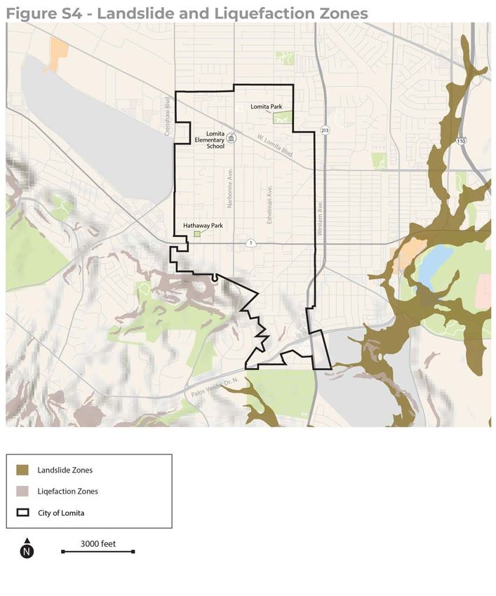
1

INTRODUCTION

         City of Lomita Safety Element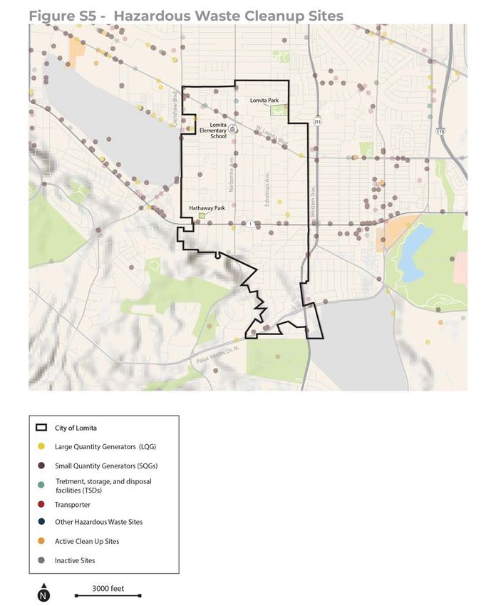
INTRODUCTION

Introduction
                                                                                           LOMITA HAZARD MITIGATION PLAN
The Safety Element of the General Plan addresses natural and                               (LHMP)
human-caused hazards in the City of Lomita and the potential short-
                                                                                           The Lomita Hazard Mitigation Plan
and long-term risks to human life, property, and economic and social                       was last updated in 2018 in accordance
dislocation resulting from hazard events, including air pollution,                         with the Disaster Mitigation Act of
extreme heat, flooding, geologic hazards, hazardous materials,                             2000. Regular updates to the Hazard
and wildfires. This is one of seven elements required by State law                         Mitigation Plan ensure access to Federal
                                                                                           Emergency Management Agency (FEMA)
(Government Code 65302). Because climate change affects and
                                                                                           Hazard Mitigation Grant Program
potentially exacerbates the impact of hazards, in accordance with                          (HMGP) funding.
Senate Bill 379, this Safety Element also addresses climate change
within each applicable hazard section.

This Safety Element is organized to include an Existing Conditions                         ACCESS AND FUNCTIONAL NEEDS
section, which outlines each hazard facing Lomita, who these hazards                       Access and functional needs populations
affect, and how the City of Lomita (City) is currently addressing                          are people with disabilities or health
these hazards. This Safety Element also includes a Goals, Policies,                        problems, seniors, children, limited
and Actions section, which provides the City’s safety roadmap to                           English proficiency, and transportation
2040, including a comprehensive hazard mitigation and emergency                            disadvantaged that affect their ability
                                                                                           to prepare, respond, or recover from
response strategy. Goals, policies, and actions are organized by four                      hazards.
planning phases designed to enhance the resilience of a community:
mitigate, prepare, respond, and recover. This Safety Element also
incorporates and augments mitigation policies contained in the
Lomita Hazard Mitigation Plan (LHMP).1 Because many hazard
incidents disproportionately affect individuals with access and
functional needs, these populations are considered throughout this
Safety Element.

This Safety Element directly relates to topics in the Land Use,
Circulation, and Conservation and Open Space Elements of the
General Plan. The Safety Element identifies hazards and hazard
abatement provisions to guide land use decisions related to zoning,
subdivisions, and entitlement permits. The Safety Element also
addresses emergency response and evacuation routes, which informs
the Circulation Element to ensure that streets are sized adequately
for fire truck access and other needs of first responders. This Safety
Element also addresses community greening to improve Lomita’s
air quality and provide shade on hot days, which correlate with the
Conservation and Open Space Element.

The Safety Element is a long-term plan that uses a 20-year horizon.
The element will include policies to mitigate hazards through land
use, design measures, and programs. As a part of the General Plan,
the Safety Element will provide direction that the City will implement
through the Zoning Ordinance and other mechanisms. A similar,
but nuanced plan is the Local Hazard Mitigation Plan (LHMP). The
Local Hazard Mitigation Plan is a short-term, five-year strategic plan

1   City of Lomita. 2018. Hazard Mitigation Plan (Final Plan). Approved August 18, 2018.
    Accessed December 20, 2020. http://www.lomita.com/cityhall/emergency_preparedness/
    Lomita-Hazmit-Plan-12-18-18.pdf.

                                                                                                City of Lomita Safety Element | 3
INTRODUCTION

that also seeks to identify and mitigate natural hazards. The LHMP is distinct from the Safety Element in
that it is created to directly respond to the requirements of the federal Disaster Mitigation Act (DMA) of 2005.
By achieving certification by FEMA, an LHMP provides the City with access to two competitive FEMA grant
programs: the Hazard Mitigation Grant Program (HMGP) and the Pre-Disaster Mitigation Program (PDM). To
maintain eligibility for FEMA funding, the City must update the LHMP a minimum of once every five years.
By integrating the LHMP with the Safety Element, the City will also achieve eligibility for additional post-
disaster funding from the State of California. Integration also allows the Safety Element’s framework of goals,
objectives, and policies to be utilized and built upon by current and future LHMPs. Policy 3.1e states the City’s
intent to incorporate future updates of the LHMP into the Safety Element.

                                                                                 City of Lomita Safety Element | 4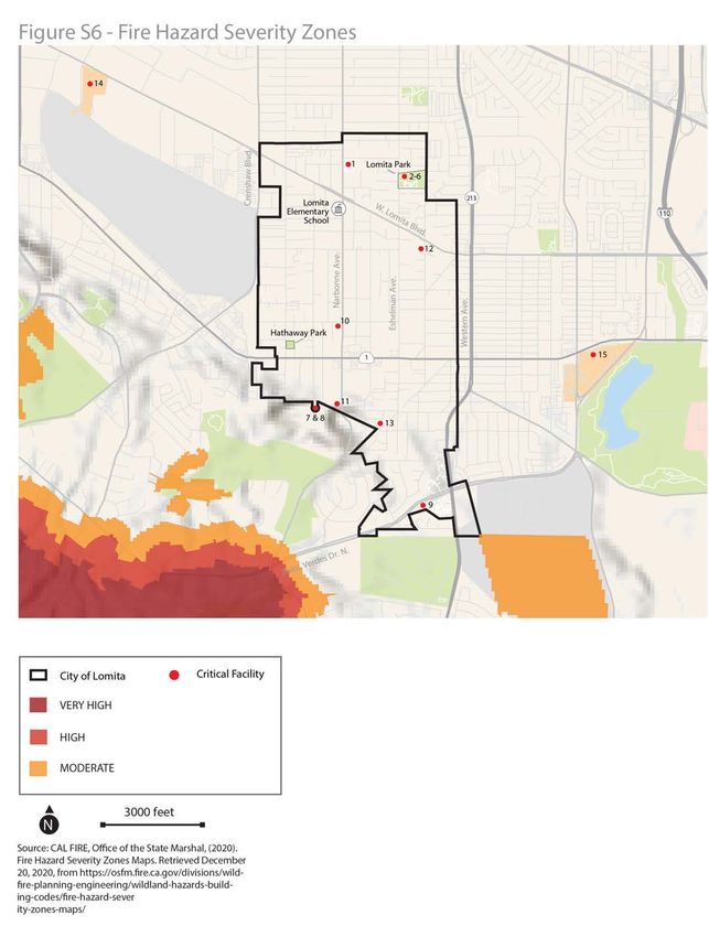
2

EXISTING
CONDITIONS

         City of Lomita Safety Element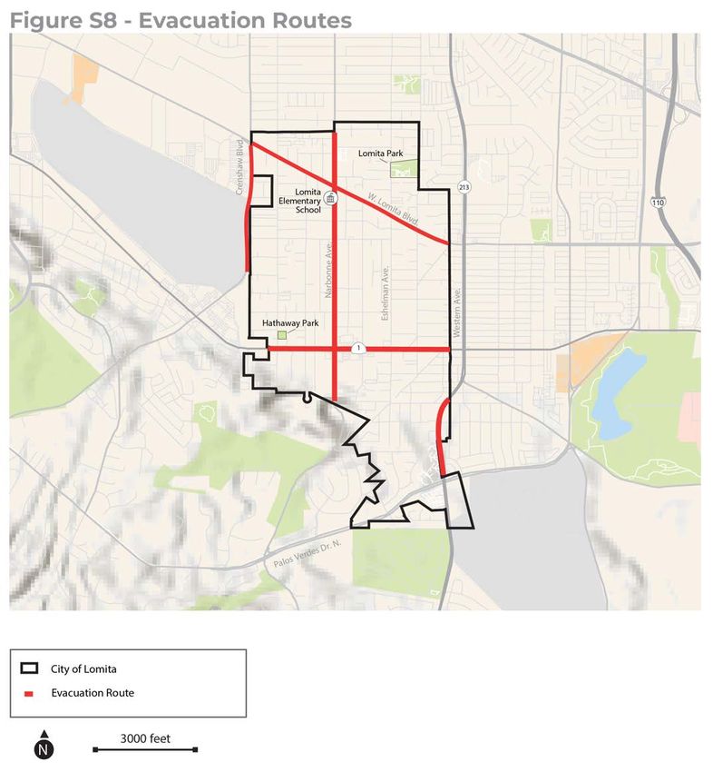
EXISTING CONDITIONS

Existing Conditions
This section outlines each hazard with five familiar questions: what, when, where, who, and how. For each
hazard, this assessment explains what the hazard is and what causes it to occur in Lomita; when the hazard
occurs, including if the hazard is seasonal or is forecasted to get worse as a result of climate change; where in
Lomita this hazard is most likely to occur; who is most vulnerable to each hazard; and lastly, how the City is
already addressing this hazard and how initiatives can be built upon and improved in the future.

This section addresses the following six hazards, as well as emergency preparedness and response:
    ‒     Air pollution
    ‒     Extreme heat
    ‒     Flooding
    ‒     Geologic hazards
    ‒     Hazardous materials
    ‒     Wildfires

AIR POLLUTION
What
The State of California measures ten air pollutants. These pollutants are measured separately and are
compared to a healthy level determined by the State. Air is considered polluted when it does not meet the
standard set by the State or Federal government. According to the South Coast Air Quality Management
District’s 2016 Air Quality Management Plan, in Los Angeles County, three pollutants—ozone, coarse
particulate matter (PM10), and fine particulate matter (PM2.5)—are in violation of either the State or Federal
standard.2 Air pollution varies locally as it moves away from the source of pollution; it is more concentrated
along major transportation corridors and industrial facilities. Air pollution is likely worse in neighborhoods
closer to Pacific Coast Highway and Western Avenue.

OZONE
Ground-level ozone is most commonly known as smog. Smog is caused by a chemical reaction when sunlight
interacts with nitrogen oxides and volatile organic compounds, both of which are emitted from vehicles.
As temperatures increase, it is anticipated that the amount of ground-level ozone will also increase if the
amount of car traffic and other sources of nitrogen oxides and volatile organic compounds do not decrease.3

Some main contributors to the pollutants that form ground-level ozone in Lomita are cars, trucks, and
industrial processes, specifically near Pacific Coast Highway and Western Avenue. Ground-level ozone
can cause health issues, including difficulty breathing, coughing, inflamed airways, asthma attacks, and
heart disease.

2       SCAQMD (South Coast Air Quality Management District). 2017. Final 2016 Air Quality Management Plan. March 2017. http://www.aqmd.gov/
        docs/default-source/clean-air-plans/air-quality-management-plans/2016-air-quality-management-plan/final-2016-aqmp/final2016aqmp.
        pdf?sfvrsn=15.
3       EPA (U.S. Environmental Protection Agency). 2018a. “Ground-level Ozone Basics.” U.S. Environmental Protection Agency Website. Accessed July
        16, 2020. https://www.epa.gov/ground-level-ozone-pollution/ground-level-ozone-basics.

                                                                                                           City of Lomita Safety Element | 6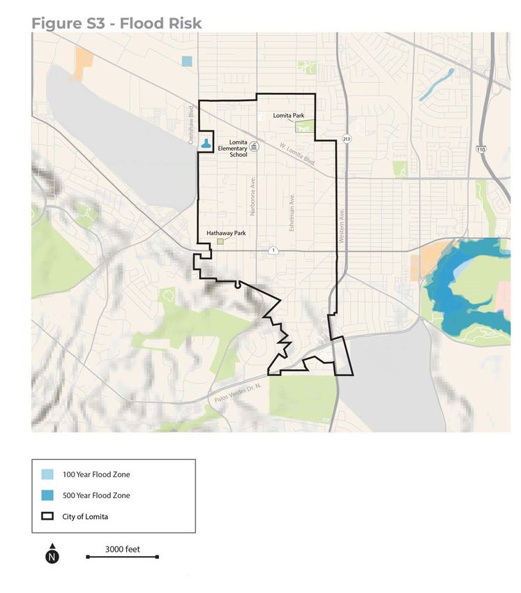
EXISTING CONDITIONS

PARTICULATE MATTER
Particulate matter is made of microscopic solids and liquids in the air that are small enough to breathe. PM10
is particulate matter measuring 10 microns or less in diameter, which is approximately 1/7th the thickness of
a human hair. PM2.5 is 2.5 microns or less in diameter, which is approximately 1/28th the thickness of a human
hair. PM10 is often made up of dust and ash, and PM2.5 results from burning fuel for cars, trucks, and industrial
processes. PM2.5 is small enough to get into the human bloodstream and poses a greater risk to human health.4
Similar to ozone, particulate matter causes asthma and heart disease.

When
Lomita already experiences air pollution, and it will get worse as a result of climate change and likely have
the greatest impact in summer when temperatures are higher. Longer warm seasons can mean longer pollen
seasons, which can increase allergies and asthma episodes. Higher temperatures associated with climate
change can also lead to an increase in ozone. Although the future level of air pollution will depend, in part, on
State laws mandating standards for fuel efficiency and potential electrification of cars and trucks, the current
air quality in Lomita does not meet State standards.

Where
Air pollution is higher in communities with low tree cover, limited park access, and higher levels of traffic. In
Lomita, neighborhoods with these attributes are located in the west and north, as shown in Figure S-1,
Air Pollution.

Who
People with existing health conditions, such as asthma and heart
disease, are more sensitive to air pollution. These conditions                                   FENCELINE COMMUNITIES
are also often caused by living near sources of air pollution in                                 Fenceline communities are
fenceline communities (as shown in Figure S-1). The average rate                                 neighborhoods near sources of industrial
                                                                                                 pollution, such as ports, refineries, and
of asthma-related emergency department visits is between 30 to 46
                                                                                                 major transportation routes.
people per 10,000 visits; however, this average increases to between
46 and 72 people per 10,000 visits in the area of Lomita between
Pacific Coast Highway and West Lomita Boulevard.

Additionally, people who spend more time outdoors, including young children, people who work outdoors,
and people in households without cars, are often exposed to polluted air at higher rates.

How
The City’s Energy Efficiency Climate Action Plan includes actions to promote tree planting during development
plan check, to work with the community to develop a tree planting group, and to develop a tree planting
program. However, the actions are not connected to a specific goal for reducing air pollution. The City’s
Climate Action Plan contains policies addressing air pollution through the built environment through
emphasis on electrical vehicle use, active forms of transportation, and a mix of land uses that increases
opportunities for access by walking or biking. Additionally, the Climate Action Plan sets out to increase urban
greening through the promotion of urban gardens, identification of new green space opportunities, and
landscape maintenance. Further, the City participates in annual Arbor Day events to help raise awareness
about tree planting and a ceremonial tree is planted at this event.

4   EPA. 2018b. “Particulate Matter (PM) Basics.” U.S. Environmental Protection Agency Website. Accessed December 18, 2020. https://www.epa.gov/
    pm-pollution/particulate-matter-pm-basics.

                                                                                                       City of Lomita Safety Element | 7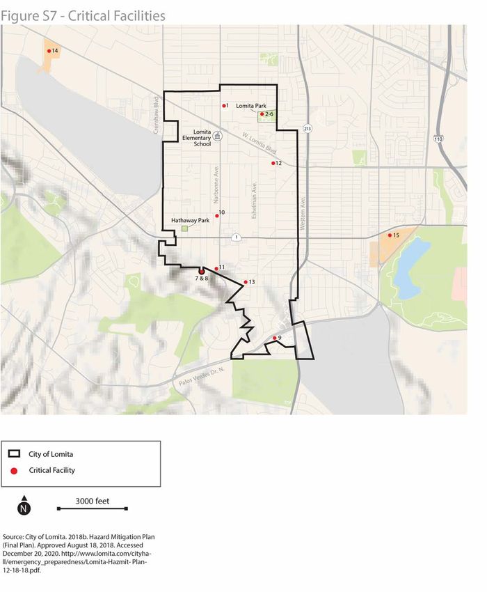
EXISTING CONDITIONS

Figure S-1: Air Pollution in Lomita

Source: Public Health Alliance. 2020. “The California Healthy
Place Index.” https://map.healthyplacesindex.org/.
Open Street Map. 2019. www.openstreetmap.com

                                                                City of Lomita Safety Element | 8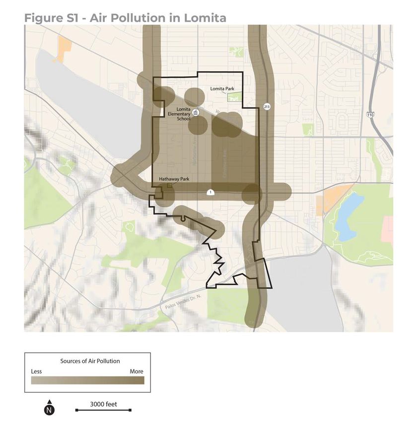
EXISTING CONDITIONS

AIRPORT LAND USE AND COMPATIBILITY AND SAFETY
What
Airports are typically categorized by type of activities, including commercial service, cargo service and
general aviation. Airports and certain types of development can be hazardous when located close together,
which is why careful planning must be done to minimize risk and plan for a coordinated response to any
potential incident. Although hazardous incidents associated with air transportation are extremely rare, aircraft
accidents have the potential to be severe.

Where
The closest airport is the Torrance Municipal Airport which borders Lomita on the west. This airport is a
general aviation airport providing home to primarily private aircraft and Fixed Base Operators which are
available for flight instruction, aircraft repair and charter flights. The Torrance Municipal Airport is also home
to Robinson Helicopters, the largest manufacturer of private helicopters in the United States. Consistent with
State aviation regulations, a Runway Protection Zone (RPZ) has been established at each end of each active
runway at Torrance Airport. There are 5 single family residential parcels in Lomita that are within a RPZ and the
Airport Influence Area for Torrance Municipal Airport.

Who
Airports create noise and safety hazards that can be detrimental for residents, businesses, and property
owners. The Los Angeles County Airport Land Use Commission has adopted an Airport Influence Area for the
Torrance Airport. This describes the area in which noise, overflight, safety, or airspace protection factors may
affect land uses or necessitate restrictions on those uses, as determined by the Airport Land Use Commission.
The Airport Influence Area for the Torrance Airport is generally defined by the 65‐dBA CNEL noise contour.
In accordance with state regulations (Section 11010 of the Business and Professions Code and Sections
1102.6, 1103.4, and 1353 of the Civil Code), the seller of a property in the Airport Influence Area must provide
the purchaser with a Real Estate Transfer Disclosure Statement that includes a “Notice of Airport in Vicinity,”
indicating that the property is located in an Airport Influence Area.

While Lomita has no authority over airspace, noise complaints are referred to the Torrance Municipal Airport.
Along with other cities located in the South Bay, Lomita supports efforts by the City of Torrance to implement
and maintain stringent noise control guidelines.

How
To reduce the noise incompatibility and safety risks associated with airports, the City follows land use
planning standards determined by the Federal Aviation Administration (FAA) relative to land in the RPZ.5
Ensuring that development follows the FAA guidance on the few parcels within the influence area is important.
For Lomita’s parcels, this means keeping development under 200 feet in height to avoid further approvals from
the FAA. All parcels in the RPZ are zoned and used for single family residential uses currently, with no plans to
change this land use, keeping future uses of this land well below FAA height guidance to ensure safety.

5   Los Angeles County Airport Land Use Commission. 2004, December 1st. “Los Angeles County Airport Land Use Plan.” https://planning.lacounty.
    gov/assets/upl/data/pd_alup.pdf

                                                                                                       City of Lomita Safety Element | 9
EXISTING CONDITIONS

EXTREME HEAT
What
Extreme heat is a hazard that occurs on hot days, warm nights, or during heat waves, and can result in heat-
related illness and hospitalization. Extreme heat is measured locally, as communities are acclimatized to their
historic environment. In Lomita, average high temperatures range around 78°F from June through September.
The record high temperatures range from 91°F to 111°F. An extreme heat day is one that is in the hottest 2% of
days observed between 1960 and 1990. In Lomita, an extreme heat event is a day hotter than 91.7°F.6

Heat waves and extreme heat days are made worse by the urban
heat island effect. The urban heat island effect inflates average                                   URBAN HEAT ISLAND EFFECT
annual urban air temperatures 1.8°F to 5.4°F warmer than other                                      The urban heat island effect occurs when
areas. Heat islands also increase energy demand for air conditioning.                               dark urban surfaces, such as roofs and
                                                                                                    roads, absorb heat and slowly release
Figure S-2, Greenery and the Urban Heat Island Effect, illustrates
                                                                                                    the heat over time. At night, these
the urban heat island effect.                                                                       surfaces transfer heat to the air, creating
                                                                                                    warmer nights that do not allow people
When                                                                                                to cool off, making heat waves more
Extreme heat occurs in the summer and early fall in Lomita. Climate                                 dangerous.
change is expected to increase the average temperature year-round,
including the frequency of extreme heat days. There is no projected
change in the number of extreme heat days in Lomita.7 Historically,
heat waves would last 2.2 days, but this duration is projected to
increase to 3.3 days between 2020 and 2050.

Where
There are more asphalt surfaces, more buildings, and less vegetation in urban areas in the center of Lomita.
Based on a conservative estimate from the Impervious Cover Calculator provided by the California Office of
Environmental Health Hazard Assessment, Lomita has approximately 50% impervious cover.8 Compared to
most communities in California (but typical for the region), Lomita has more paved surfaces, creating a higher
likelihood that the urban heat island effect could cause extreme heat events; however, Lomita’s proximity to
the ocean and tree cover reduce this risk.

Who
People can be adversely affected by extreme heat if they have existing health conditions or spend increased
time outdoors working, commuting, or playing. People who depend on walking, biking, or transit to get
around; older adults; and young children are at risk for heat stroke. Lomita has relatively consistent levels of
active transportation and automobile access citywide.9 Similarly, rates of outdoor workers, children, and older
adults are all slightly lower than state average.10

How
As discussed above, Lomita has approximately 50% impervious cover. The impervious cover is made
up of surface material such as asphalt that perpetuates the urban heat island effect, resulting in higher
temperatures and warmer nights. The City’s Energy Efficiency Climate Action Plan11 includes a goal to decrease

6    Cal-Adapt. 2020. “Extreme Heat Days and Warm Nights.” Accessed December 18, 2020. https://cal-adapt.org/tools/extreme-heat/.
7    Cal-Adapt 2020.
8    California Office of Environmental Health Hazard Assessment. 2020. “Impervious Surface Analysis.” Accessed December 20, 2020. https://oehha.
     ca.gov/ecotoxicology/report/impervious-surface-analysis.
9    Public Health Alliance. 2020. “The California Healthy Places Index.” https://map.healthyplacesindex.org/.
10   US Census Bureau. 2015. American Community Survey 2011-2015 Estimates. Table S2401.
11   City of Lomita. 2015. Energy Efficiency Climate Action Plan. Provided by the City of Lomita.

                                                                                                        City of Lomita Safety Element | 10
EXISTING CONDITIONS
Figure S-2Greenery
Figure S-2: - Greenery and
and the the Urban
Urban Heat
Heat Island Island Effect
Effect
Greenery and the urban heat island effect Little Greenery
.
1 2 3 4
e
Solar energy is emitted Heat is absorbed and retained Heat is slowly emitted throughout the day Increased temperatures discourage pedestrian
Av
by the sun by dark, urban surfaces and evening, increasing temperatures traffic, negatively impacting local economy
y
ne
ow
D
Large amounts of greenhouse
gas emissions are released
into the atmosphere due to
little absorption from small
number of trees
e.
Av
y
ne
ow
D
Fir
es
ton
eB
lvd
.
.
e
Av
an
ol
D
Greenery and the urban heat island effect More Greenery
.
1 2 3 4
e
Solar energy emitted by the Less heat is retained, Auto emissions Cleaner air, cooler weather creates a
Av
sun partially absorbed by trees more shade produced partially absorbed by trees pedestrian-friendly environment
y
ne
positively impacting local businesses
ow
D
Less greenhouse gas
emissions are released
into the atmosphere due
to more absorption
from more trees
Fir
es
ton
eB
lvd
.
.
e
Av
an
ol
D
City of Lomita Safety Element | 11EXISTING CONDITIONS
energy demand through reducing the urban heat island effect. Four implementing actions are listed within
this goal to promote tree planting at plan checking, to develop a tree planting program, to adopt a cool roof
ordinance, and to adopt a cool pavement ordinance.
There are no established cooling centers in Lomita, but libraries and other community facilities that are air
conditioned and open to the public during extreme heat events could serve as de facto cooling centers. People
can use cooling centers to escape the heat if they do not have access to air conditioning or cannot afford to
run theirs at home. De facto cooling centers include the Tom Rico Recreational Center and Stephenson Center
located in Lomita Park Community Center and Lomita Library.
FLOODING
What
Flooding is caused by increased rain, which causes rivers and urban drainage basins to fill and overflow.
Increased flooding occurs when rain falls over a shorter period of time, even if there is less overall rain, because
the soil does not have enough time to absorb the rainfall. Flooding occurs in low-lying areas near creeks and
other waterways. Generally, the floodplain most often refers to the area that would be inundated by a 100-year
flood, which is a flood that has a 1% chance of occurring in any year. The 500-year floodplain is the area that
has a 0.2% change of being flooded in any year. Floodplain maps are based on historic observations; however,
flood events are projected to happen more frequently as climate change causes more intense rainfall.
When
Flooding is more likely to occur in the winter months (December, January, February) when Lomita receives the
most rain. Climate change is predicted to increase the number of extreme rain events, when large amounts of
rain falls over a short period of time, does not have time to soak into the ground, and overwhelms stormwater
infrastructure. The most recent localized flooding event took place in April 2016, which resulted from a storm
event.12
Where
As shown in Figure S-3, Flood Risk, Lomita is not vulnerable to 100-year or 500-year flood events. However,
localized flooding could still occur in isolated pockets of Lomita due to urban flooding from severe weather
events.13 According to the LHMP, storm drain deficiencies are located at Eshelman Avenue/262nd Street/
Appian Way, Pennsylvania Avenue from approximately 251st to 254th Streets, the western terminus of 256th
Street, and Lomita Boulevard at Pennsylvania Avenue, which could result in flooding and inundation of
private properties. The Tom Rico Recreational Center and Stephenson Center, both located at Lomita Park, are
vulnerable to localized flooding hazards resulting from a severe weather event.14
Additionally, portions of southern Lomita are subject to flooding due to dam inundation. There are two
enclosed water reservoirs in Torrance referred to as the Walteria and Ben Haggot reservoirs. Because of their
size, 18 MG and 10 MG, these reservoirs are considered dams and are therefore under the purview of the
California Division of Dam Safety. Each are in satisfactory condition and have a high downstream hazard. These
dams’ inundation areas primarily cover roadways and not structures in Lomita.15
Who
People can be vulnerable to flooding due to social isolation and/or physical disabilities leading to difficulty
evacuating during a flood event. Additionally, low-income renters can face increased challenges in recovering
12 City of Lomita 2018.
13 City of Lomita 2018.
14 City of Lomita 2018.
15 California Department of Water Resources. 2019, September. Dams Within Jurisdiction of the State of California.
City of Lomita Safety Element | 12EXISTING CONDITIONS
Figure S-3: Flood Risk
City of Lomita Safety Element | 13EXISTING CONDITIONS
from flood events because they are less likely to have renter’s insurance and can face higher levels of
displacement and homelessness if their residence is damaged during a flood event.
How
The City participates in the National Flood Insurance Program, which makes flood insurance available
in communities that enact minimum floodplain management rules consistent with the Code of Federal
Regulations Section 60.3. The LHMP includes multiple flooding-related policies and actions that call for
improving water infrastructure and streets at various street segments, replacing water pipes to eliminate dead-
end pipes, improving water circulation, reducing risk of breaks and leaks, and replacing pipelines built in 1928
or earlier.16
GEOLOGIC HAZARDS
What
Geologic hazards are natural geologic processes with the ability to impact life, health, or property. Lomita
is vulnerable to geologic and seismic hazards such as earthquakes, but is not likely to be susceptible to
landslides or liquefaction, as shown in Figures S-4, Landslide and Liquefaction Zones.
Earthquakes are sudden ground-shaking events caused by the release of pressure in the earth. This quick
release of pressure poses a safety risk to people and structures due to the unpredictability of magnitude
and timing. A 100-year earthquake is a major earthquake event that is calculated to have a 1% chance to
occur each year and theoretically occurs every 100 years. Likewise, a 500-year earthquake is one of such a
magnitude that it has a 0.2% chance of occurring each year and theoretically occurs every 500 years.
When
In January 1994, the magnitude 6.7 Northridge Earthquake (thrust fault) produced severe ground motion,
causing 57 deaths and 9,253 injuries, and left more than 20,000 people displaced. Scientists have stated that
such devastating shaking should be considered the norm near any large thrust earthquake. Recent reports
from scientists of the U.S. Geological Survey and the Southern California Earthquake Center say that the Los
Angeles area could expect one earthquake every year of magnitude 5.0 or more for the foreseeable future.
The San Andreas Fault is approximately 55 miles northeast of Lomita and is considered the most seismically
active fault in the Southern California region. Geologic evidence suggests that the San Andreas Fault has a 50%
chance of producing a magnitude 7.5 to 8.5 quake (comparable to the great San Francisco earthquake of 1906)
within the next 30 years. Other active faults within 20 miles of Lomita include the Newport–Inglewood Fault
and the Palos Verdes Fault. A significant earthquake originating along any of these or other regional faults
could cause damage to buildings and infrastructure, as well as injuries and fatalities, in Lomita.17
Where
ALQUIST-PRIOLO EARTHQUAKE
Active faults are identified by the U.S. Department of Conservation, FAULT ZONES
and a zone around them is prohibited from new developments to
The Alquist-Priolo Special Studies
prevent repetitive loss of structures and threats to the safety of Zone Act (1994) defines an active fault
occupants. The unsafe areas around active faults are regulatory as one that has ruptured in the last
zones referred to as Alquist-Priolo earthquake fault zones. There 11,000 years. The act provides mapping
are no Alquist-Priolo earthquake fault zones within Lomita city limits. resources for the public to strengthen
awareness and prevent unsafe
construction in these areas.
16 City of Lomita 2018.
17 City of Lomita 2018.
City of Lomita Safety Element | 14EXISTING CONDITIONS
Figure S-4: Landslide and Liquefaction Zones
City of Lomita Safety Element | 15EXISTING CONDITIONS
According to the LHMP, Lomita has 12 critical facilities, each of
which is at risk from an earthquake (see the Emergency Preparation UNREINFORCED MASONRY BUILDING
and Response section below for a map and list of each facility). Due An unreinforced masonry building is a
to their unpredictability, sensitivity to seismic hazards is different type of building where load-bearing
from many other hazards. Older buildings are more likely to sustain walls, non-load-bearing walls, or other
serious damage from earthquakes, because newer buildings were structures, such as chimneys, are made
of brick, cinderblock, tiles, adobe, or
built to meet higher earthquake standards. Of the city owned
other masonry material that is not
buildings, two were built before 1970: The Railroad Museum and the braced by reinforcing material, such as
gymnasium attached to the Tom Rico Center at Lomita Park. The rebar in a concrete or cinderblock.
Railroad Museum is a converted house that is built at ground level These buildings were banned in
and supported by concrete, making it more earthquake resistant California after the 1933 Long Beach
Earthquake. Unreinforced masonry
than raised foundations and not in need of retrofits at this time. The
buildings are the most at-risk during an
gymnasium was built in the 1940’s and is a single-story structure earthquake hazard.
about 30 feet in height. This building is in good condition, but the
age of the structure makes it more at risk, and future evaluations
would be prudent. There are 15 unreinforced masonry buildings
within Lomita that have been identified for upgrade in order to meet
current requirements.
Who
No populations are specifically more at risk because of an earthquake, but low-income households may be
more likely to live in older and retrofitted homes.
How
The LHMP includes earthquake action items to improve internal facility non-structural resistances to damage
and injury due to earthquakes, and action items to work with property owners of unreinforced masonry
structures to bring these buildings into compliance with existing building codes. This would require the
property owner to hire a structural engineer to evaluate buildings and design retrofits to bring the structure
up to code, then hire a contractor to complete the work. The Community and Economic Development
Department was identified in the LHMP to support the property owners. Measures for new development are
addressed in the building code. Lomita has adopted the 2019 California Building Code, as amended by Los
Angeles County.
Peakload Water Requirements
Water is a necessary utility which is important to discuss in the context of earthquakes due to the potential for
the loss of connections across long-distance pipelines and infrastructure. The City of Lomita’s current water
demand is 2,070 acre feet per year (which is equal to an average day demand of 1.85 million gallons per day).
Future water demands are expected to stay relatively steady due to Lomita’s built out nature, the water use
efficiency measures being put in place, and the potential for recycled water.18
Lomita’s existing water supply comes from groundwater and imported water. As of 2019 the City has been
using only imported water because the groundwater source has had benzene detected in it. The average
amount of water imported annually in the last five years is 1,814 acre-feet. The City has two imported water
connections which have capacities of 1,800 gallons per minute and 3,350 gallons per minute. The City also has
the rights to extract 1,352 acre-feet of groundwater annually from the West Coast Groundwater Basin. With
climate change projected to increase the frequency and severity of droughts, it is likely that water supplied by
these sources will be reduced.19 That being said, the Water Replenishment District has injection wells which
18 City of Lomita. 2021, June. 2020 Urban Water Management Plan. https://2z9y8z223mzgrqwntrujrw16-wpengine.netdna-ssl.com/wp-content/
uploads/2021/06/Lomita-FINAL-2020-UWMP-June-2021.pdf
19 Hall, A., N. Berg, and K. Reich. 2018. Los Angeles Summary Report. California’s Fourth Climate Change Assessment. University of California, Los
Angeles. Publication number: SUM-CCCA4-2018-007.
City of Lomita Safety Element | 16EXISTING CONDITIONS
work to replenish groundwater supply for the area. Alternate water sources are discussed in the Urban Water
Management Plan, including the potential use of greywater systems, desalinateed seawater.
In the event of a loss of water sources, Lomita has a storage capacity of 5.4 million gallons within two
reservoirs, which would supply potable water for approximately 3 days of regular use. The Cypress Reservoir
is located next to the City’s water well and has a capacity of 5.3 million gallons. The Harbor Hills reservoir is an
elevated steel tank and has a 100,000-gallon capacity. Lomita also has an emergency connection with the City
of Los Angeles and two emergency connections with the City of Torrance.20
In regard to water quality, the City is moving forward with planned upgrades to the Cypress Water Production
Facility. As of 2019, benzene was detected in the groundwater, and this upgrade will make the facility equipped
with the industry standard for removing benzene. The City has prioritized and expedited these upgrades,
which upon completion will allow the City to return to normal operations. The City and Lomita Water have
worked to educate the public on benzene and how it is being addressed through a comprehensive webpage.21
The project will help to ensure that the City can provide safe, clean water to residents, even in times of
severe drought.
HAZARDOUS MATERIALS
What
Hazardous materials are substances that can cause death, serious illness, or hazard to human health or the
environment when not properly treated, stored, transported, or disposed of. Many household substances
are considered hazardous, including gasoline, refrigerants, paint, and some gardening supplies. Nearly all
households and businesses have some amount of hazardous waste. Hazardous waste is hazardous material
that no longer has practical use but has not yet been properly disposed of. Certain businesses, such as gas
stations, auto repair shops, and dry cleaners, generate larger amounts of hazardous waste than other types
of businesses. Hospitals, clinics, and laboratories also generate medical waste, which can be hazardous. The
pollution of water from various sources can also create water which is hazardous to consume.
The Resource Conservation and Recovery Act (RCRA) is a Federal
law that was created to regulate hazardous waste to protect human CRADLE-TO-GRAVE
health, conserve resources, and reduce or eliminate hazardous A management approach that regulates
waste generation. RCRA regulates hazardous waste from cradle- generation, transportation, treatment,
storage, and disposal.
to-grave. Large Quantity Generators (LQGs) are regulated through
RCRA because they generate more than 1,000 kilograms of hazardous
waste per month or 1 kilogram of acutely hazardous waste per
month. LQGs must comply with certain State-specified requirements regarding recordkeeping, reporting,
labeling, exporting, and containers.22 Small Quantity Generators (SQGs) generate more than 100 kilograms
but less than 1,000 kilograms of hazardous waste and are also regulated through RCRA. Transporters of
RCRA-regulated waste are also regulated on their labeling, container standards, and recordkeeping. Lastly,
treatment, storage, and disposal facilities (TSDs) must comply with recordkeeping, reporting, permitting, and
other technical standards.23
20 City of Lomita. 2021, June. 2020 Urban Water Management Plan. https://2z9y8z223mzgrqwntrujrw16-wpengine.netdna-ssl.com/wp-content/
uploads/2021/06/Lomita-FINAL-2020-UWMP-June-2021.pdf
21 Lomita Water. 2021. Benzene. https://www.lomitawater.com/education/benzene/
22 California Department of Toxic Substances. n.d. “Generators.” Accessed March 17, 2021. https://dtsc.ca.gov/generators/.
23 EPA. 2020. “Resource Conservation and Recovery Act (RCRA) and Federal Facilities.” December 8, 2020. Accessed March 17, 2021. https://www.epa.
gov/enforcement/resource-conservation-and-recovery-act-rcra-and-federal-facilities.
City of Lomita Safety Element | 17EXISTING CONDITIONS
Where
Hazardous materials can potentially be found anywhere as a result of improper disposal or storage; however,
sites with large concentrations of hazardous materials are catalogued by EnviroStor. EnviroStor is a data
management program operated by the Department of Toxic Substances Control that is used to monitor,
investigate, permit, and clean up sites with known contaminants. Lomita does not have any sites listed by
EnviroStor that contain hazardous materials requiring cleanup.
Although Lomita does not contain any cleanup sites, it does contain active SQGs, LQGs, TSDs, and a
transporter. SQGs are most concentrated along major roadways including Lomita Boulevard, Pacific Coast
Highway, Narbonne Avenue, and Palos Verdes Drive. The three LQGs are spread across Lomita. The transporter
site is located on Walnut Street near Pacific Coast Highway. Northwestern Lomita contains the two TSD sites.
Lomita detected benzene in the groundwater at levels exceeding the State’s standards. In 2018 benzene was
detected but at levels below State standards. Groundwater had been the main source of water for the City, and
the City has been importing water since then. The planned upgrades to the Cypress Water Production Facility
will allow a return to normal operations.
Who
There are a number of SQGs, three LQGs, two TSDs, and one transporter of hazardous waste in Lomita. There
are no hazardous waste cleanup sites in Lomita. Figure S-5, Hazardous Waste Sites, shows Lomita’s SQGs,
LQGs, TSDs, and transporter, as well as active hazardous waste cleanup sites within approximately 1 mile of
Lomita city limits.
How
The LHMP24 includes an earthquake action item that would improve internal facility non-structural resistances
to damage and injury due to earthquakes, part of which includes a note that hazardous material storage
should be secured. The State and Federal government provide additional regulation of hazardous waste
storage and transportation.
The City also addresses household hazardous waste through a collaboration with Los Angeles County. Annual
or bi-annual household hazardous waste drop offs are allowed at City Hall. This is promoted through the
Lomita e-newsletter and bulletin. The nearest permanent hazardous waste disposal is operated by LA County
and is found approximately three miles south of the City at the Gaffey Street SAFE Collection Center.
WILDFIRES
What
Wildfires are most commonly caused by lightning or humans via electrical equipment and vehicles, and
often start unnoticed. They are known to spread more quickly on dry, windy days and move more easily in
an uphill direction and in areas with higher-density vegetation. Wildfires are a natural and important part
of the ecosystem, but can become more intense and dangerous as a result of climate change and poor land
management.
When
Lomita is an almost completely developed community, and the remaining vacant land is limited to scattered
parcels. Fires are not likely to occur in Lomita due to its largely urban and developed landscape. However,
there is potential for wildfires to occur in nearby fire hazard severity zones, such as in the City of Rancho
24 City of Lomita 2018.
City of Lomita Safety Element | 18EXISTING CONDITIONS
Figure S-5: Hazardous Waste Cleanup Sites
City of Lomita Safety Element | 19EXISTING CONDITIONS
Palos Verdes, and spill into city limits25 (see Figure S-6, Fire Hazard Severity Zones Risk in Lomita). Climate
change projections indicate that wildfire may increase in Southern California. Approximately 80% of wildfires
occur in the summer and fall, with one-quarter of annual wildfires occurring during Santa Ana wind events.
Climate change is likely to intensify the fall fire season by extending the dry season further into Santa Ana wind
season.26
Where
There are no fire hazard areas located within city limits. Regardless,
wildfires can start outside and spread into Lomita, or can create STATE RESPONSIBILITY AREAS
dangerous air pollution by blowing ash into Lomita. The southeast The State Responsibility Area is where
portion of Lomita is located adjacent to a moderate fire hazard CAL FIRE has a legal responsibility to
provide fire protection.
severity zone, and the southwest portion of Lomita is located
approximately 1 mile from moderate, high, and very high fire hazard
severity zones (see Figure S-6). There are no State Responsibility
Areas within or near Lomita. Historically, only two wildfires have
gotten within a half-mile of the southern edge of Lomita, and none
have crossed city limits.
Who
Similar to flooding, people can be vulnerable to wildfire due to social isolation and/or physical disabilities that
lead to difficulty evacuating. People with pre-existing health conditions, such as asthma, are more sensitive to
hazardous air. Additionally, households without access to a car can face difficulty getting groceries or meeting
daily needs during hazardous air events.
How
Planning for evacuation and creating defensible spaces in new and existing developments are key to
mitigating the risk of wildfire. The City takes part in the Hazard Mitigation Grant Program, which helps states
and local governments implement long-term hazard mitigation measures for natural hazards by providing
federal funding following a federal disaster declaration. The Hazard Mitigation Grant Program applies to
projects that would retrofit structures to minimize damage from wildfires, among other natural hazards, and
that would plant fire-resistant vegetation in potential wildland fire areas. The LHMP does not have mitigation
measures directly for wildfire mitigation because Lomita is not located in a fire hazard severity zone; however,
mitigation measures such as protecting power lines and infrastructure from potential windstorm damages
indirectly prevent potential urban fires from occurring. The City has adopted the California Fire Code as
amended by Los Angeles County, which regulates fuel modification and defensible space regulations.
Lomita also regulates address signage on homes, which is an aspect of fire and emergency response. The
City currently allows address nameplates to a certain size, although the municipal code does not specify the
location of these or require them. Vegetation clearance maintenance along roadways is another aspect that
impacts fire mitigation, evacuation, and emergency response. The roadway clearance is under the jurisdiction
of the road owner, which in most cases is the City of Lomita, but also includes CalTrans for Pacific Coast
Highway and Western Avenue, which are designated state highways. Lomita does not maintain any fuel breaks
within city limits.
The City’s actions are important, but many wildfire risks come from outside city limits, making other municipal
efforts noteworthy for the safety of Lomita’s residents. Under extreme wind and drought conditions, fire can
quickly travel through jurisdictions, across open spaces, riparian corridors, structures, and large lot residential
tracts of land. One way that communities address wildfire is through the formation of fire safe councils;
25 City of Lomita 2018.
26 OPR (Governor’s Office of Planning and Research). 2019. California’s Fourth Climate Change Assessment. Los Angeles Region Report. Accessed
December 30, 2020. https://www.energy.ca.gov/sites/default/files/2019-11/Reg%20Report-%20SUM-CCCA4-2018-007%20LosAngeles_ADA.pdf.
City of Lomita Safety Element | 20EXISTING CONDITIONS
Figure S-6: Fire Hazard Severity Zones
City of Lomita Safety Element | 21EXISTING CONDITIONS
however, there are no fire safe councils within 30 miles of Lomita. Communities also develop Community
Wildfire Protection Plans to mitigate fire risk and become competitive for grant funding. Fires originating
from the City of Rolling Hills Estates are the most direct fire risk to Lomita, but no Community Wildfire
Protection Plan has been developed for Rolling Hills Estates. The closest city to complete a Community
Wildfire Protection Plan was the City of Rolling Hills in 2020. This plan prioritizes fire mitigation, community
preparedness, and evacuation strategies for Rolling Hills, and these efforts can benefit Lomita by reducing
nearby fire risk which could, if not contained, spread fire into the adjacent Rolling Hills Estates and then into
Lomita’s city limits.27
EMERGENCY PREPARATION AND RESPONSE
Emergency preparation and response are important components in ensuring residents are ready for hazards
and first responders can adequately serve residents in the event of a hazard. The City has an Emergency
Operations Plan which informed this element and acts as an extension to the State of California Emergency
Plan and the Los Angeles County Operation Area EOP.28
Preparedness
The Los Angeles County Fire Department provides fire response services in Lomita. The Los Angeles County
Fire Department regularly visits schools and provides community-level response education through its
Community Emergency Response Team (CERT) training program. CERT programs educate volunteers about
disaster preparedness and basic response skills, such as fire safety and medical response.
Response
The Los Angeles County Fire Department and Los Angeles County Sherriff Department respond to small- and
large-scale hazard events in Lomita. Currently, the City’s response capacity meets the needs of the community;
however, hard-to-reach populations with functional and medical needs still face challenges evacuating.
Regarding mutual aid and coordination, the City of Lomita is located within OES Mutual Aid Region I, and
the OES Southern Administrative Region. During local emergencies, mutual aid is requested by the Incident
Commander. The City of Lomita’s Emergency Operation Plan includes recommended National Incident
Management System and Standardized Emergency Management System trainings, which the City of Lomita
bases its training decisions on for designated emergency personnel. Another important aspect of emergency
response includes having visible and legible addresses present on residences, which allows emergency
personnel to respond quickly to calls. The City has amended the California Fire Code to create legible and
visible address requirements, which varies in required height dependent upon the distance of the address
signage from the street or road fronting the property.29
EMERGENCY RESPONSE FACILITIES
Emergency response facilities are those activated during an emergency and used to respond to the hazard.
The City contracts with the Los Angeles County Fire Department for fire protection and other fire-related
services. There is one fire station, Fire Station No. 6, located at 25517 Narbonne Avenue, in Lomita. This fire
station is located on the southwestern side of Lomita, which is near the fire hazard severity zones located to
the southwest, outside of city limits.
27 City of Rolling Hills. (2020, July). Community Wildfire Protection Plan. https://www.rolling-hills.org/CWPP_final_2020-09-10_v2020.1.pdf
28 City of Lomita. (2017, August 23rd). Emergency Operations Plan. http://www.lomita.com/cityhall/emergency_preparedness/EOP-Basic-Plan-
2017.pdf
29 Lomita, California, Municipal Code Title 8, Chapter 20 § 170 (2016).
City of Lomita Safety Element | 22EXISTING CONDITIONS
CRITICAL FACILITIES
Critical facilities are places essential to the function of the City or public buildings that can be used to gather
people and equipment during hazard response and recovery. According to the LHMP, there are 12 critical and
essential facilities that are vulnerable to hazards, as shown in Figure S-7, Critical Facilities.30
NON-CRITICAL PUBLIC FACILITIES
Non-critical public facilities are those that can be used for hazard recovery to gather resources, distribute
information, or serve as shelters. These are generally flexible facilities that can be activated and would likely
not all be used at once during a hazard event. Non-critical facilities can also serve as cooling facilities that
provide air condition during extreme heat events. Some non-critical public facilities include Lomita’s three
schools and its public library.
EVACUATION ROUTES
In the event of an extreme fire, flood, or other circumstances, evacuation may be necessary. To preserve the
lives of Lomita residents, it is important to ensure that the routes used for evacuation are unobstructed and
in good condition. Evacuation routes in Lomita include Pacific Coast Highway, Western Avenue, Narbonne
Avenue, Lomita Boulevard, and Crenshaw Boulevard, as shown in Figure S-8, Evacuation Routes. These
evacuation routes are outside of flood, fire, landslide and liquefaction hazard areas in the City, and different
routes can be activated as necessary to avoid hazards outside the City.
30 City of Lomita 2018
City of Lomita Safety Element | 23EXISTING CONDITIONS
Figure S-7: Critical Facilities
These facilities consist of the following, with a corresponding
number on Figure S-7:
1. City Hall
2. Lomita Park’s Tom Rico Recreation Center
3. Lomita Park’s Stephenson Center
4. Lomita Water Maintenance
5. Public Works Building
6. Los Angeles Public Works Yard
7. Cypress Water Production Facility
8. Well Number 5
9. Harbor Hills Elevated Reservoir
10. Los Angeles County Fire Department – Fire Station Number 6
11. Los Angeles County Sheriff Department (Lomita Station)
12. Water Pump Station
13. Water Pump Station
14. Torrance Memorial Medical Center
15. Kaiser Permanente Hospital and Medical Center
City of Lomita Safety Element | 24EXISTING CONDITIONS
Figure S-8: Evacuation Routes
City of Lomita Safety Element | 25EXISTING CONDITIONS
FINDINGS
Based on the above analysis of each hazard, Lomita is most at risk
from air pollution, extreme heat, and seismic hazards (see Figure ADAPTIVE CAPACITY
S-9). The risk level for each hazard was determined by looking at Adaptive capacity is the City’s current
the potential impact for each hazard in the next 20 years (high, capacity to respond to a hazard. This is
determined by how well the City’s plans
medium, low) and the City’s current adaptive capacity (high, and programs mitigate or prepare for a
medium, low). The potential impact is determined by how likely a hazard.
hazard is to occur and how deadly and/or damaging it could be. This
is generally assessed by whether there are hazard zones in or near
a community (such as a fire hazard or flood zone), if there are large populations or important facilities in
those zones, the historic impact of that hazard, and/or the potential role of climate change. The adaptative
capacity is assessed by how well the public is educated and prepared for a hazard, if there are a high number
of vulnerable people, the emergency alert and evacuation capacity, and if important facilities (including
homes) meet hazard reduction standards through building materials and structural requirements.
Figure S-9: Hazard Risk
City of Lomita Safety Element | 26EXISTING CONDITIONS
Air Pollution
Residents of Lomita are exposed to chronic air pollution on a daily basis from adjacent freeways, and could
be exposed to hazardous smoke events from wildfire in nearby wildfire risk areas. Additionally, the high
proportion of people who walk, bike, or take the bus to work are more exposed to air pollution than the
average resident. The City does not currently have a comprehensive urban forestry plan or air pollution
reduction plan to adequately mitigate air pollution in Lomita.
Extreme Heat
Extreme heat is potentially the deadliest hazard for Lomita, and heat waves are projected to happen more
often and last longer as a result of climate change. Due to its proximity to the ocean, Lomita does not
experience extreme heat to the same extent as inland communities, but in areas of Lomita with more paved
surfaces and fewer trees, the effects of extreme heat can be worse because the urban environment cannot
cool off at night. Lomita does not currently have designated cooling centers or an urban forestry plan to help
reduce the risk of heat-related illness.
Seismic Hazards
Similar to many Southern California communities, an earthquake could occur in Lomita at any time. The
city-owned Tom Rico Center Gymnasium could pose risk in the event of a seismic hazard due to its age.
Additionally, 215 buildings in Lomita were
built before 1930.
Wildfire
Although there are no wildfire hazard zones
in Lomita, Lomita is adjacent to significant
wildfire risk areas in Ranchos Palos Verdes.
Historic wildfires have encroached on Lomita’s
western and southern boundaries, and
embers could potentially set fire to buildings
in Lomita. Lomita does not have defensible
space or other fire safe building standards
above what is required by the State, and a
significant number of older buildings do not
meet the current California Building Code.
City of Lomita Safety Element | 273
GOALS, POLICIES,
AND ACTIONS
City of Lomita Safety ElementGOALS, POLICIES, AND ACTIONS
Goals, Policies, and Actions
Goal 1: A built environment that protects against extreme heat and air pollution.
Policy 1.1: Improve indoor air quality and urban cooling in homes near major roads.
Action 1.1a: Create a clean air checklist for new development of sensitive land uses. This checklist
should include landscaping, ventilation systems, double-paned windows, setbacks, and barriers.
Action 1.1b: Consider applying for grant funding to install air conditioning with HEPA filters in homes
within 1000 feet of a major road for low-income households.
Action 1.1c: Continue current city efforts to repair and rehabilitate substandard housing for lower-
income households, including programs and grants to weatherize houses for extreme heat and air
pollution.
Policy 1.2: Reduce air pollution from mobile sources.
Action 1.2a: Amend the zoning code to provide incentives to increase the number of required electric
vehicle charging stations associated with a development. Identify potential locations for public EV
charging in larger parking lots.
Action 1.2b: Work with local non-profits and public agencies to advertise programs that provide
sustainable cars and slow-speed vehicles (e-bikes, e-scooter and neighborhood electric vehicles) with
an emphasis for low-income households.
Action 1.2c: Promote and enforce the use of City-designated truck routes to limit the impact of truck
ingress and egress in Lomita through the use of signage and additional monitoring in targeted issue
areas.Ensure that pedestrian walkways are unobscured and well maintained through planning and
code enforcement efforts.
Policy 1.3: Promote a healthy urban forest to mitigate air pollution and extreme heat.
Action 1.3a: Adopt a tree species guide that prioritizes trees based on having low water needs, high
canopy coverage, and adaptability to climate change and future environmental conditions.
Action 1.3b: Maintain no more than 5% of one species, 10% of one genus, and 20% of one family in
the City tree inventory.
Action 1.3c: Develop tree-protection and heritage tree guidelines to encourage developers, residents
and businesses to preserve and maintain healthy trees on private property.
Action 1.3d: Encourage a public/private partnership with local businesses, religious organizations,
community groups and neighborhood associations to establish a free private property tree program
that annually distributes trees to City residents and small businesses and prioritizes the distribution of
trees to low-income households.
Action 1.3e: Update the landscape ordinance to increase the number of shade trees in surface
parking lots for all new developments.
City of Lomita Safety Element | 29EXISTING CONDITIONS
Action 1.3f: Plant and maintain shade trees along all City streets. Prioritize tree planting based on
the existing tree canopy and the population’s vulnerability to extreme heat. Where possible, integrate
shade trees with bike and pedestrian infrastructure.
Policy 1.4: Adopt policies and standards for the built environment that reduce the urban heat
island effect.
Action 1.4a: Adopt cool pavement standards that incentivize the use of materials with increased
solar reflectance in streets and parking lots.
Action 1.4b: Encourage compliance with the Green Building Standards Code for use of cool roof
materials and green roofs.
Goal 2: A city designed to minimize risks from hazards.
Policy 2.1: Seismic retrofit essential facilities to minimize damage in the event of seismic or
geologic hazards.
Action 2.1a: Prioritize the seismic retrofits of critical facilities that are utilized in hazard response and
recovery.
Action 2.1b: Coordinate with relevant utility service providers to develop a plan for temporary
bypasses for all major utility systems (water, sewer, gas) in accordance with anticipated seismic event
damage, as identified in the Lomita Hazard Mitigation Plan.
Policy 2.2: Encourage voluntary and mandatory participation in seismic retrofits to improve
the seismic safety of all housing, while ensuring that structural improvements do not lead to
displacement.
Action 2.2a: Require seismic retrofits for major renovations in accordance with Historic and Building
Code provisions.
Action 2.2b: Require the retrofitting of unreinforced masonry structures to minimize damage in the
event of seismic or geologic hazards.
Policy 2.3: Continue to require appropriate seismic and soil studies to reduce risk for new
buildings and infrastructure.
Action 2.3a: Continue to require a preliminary soil report and a report of satisfactory placement of fill
prepared by a licensed civil engineer for all buildings and structures supported on fill.
Action 2.3b: Continue to require a preliminary report for all buildings and structures supported on
natural ground unless the foundations have been designed in accordance with the Building Code.
Action 2.3c: Continue to require soil reports and implement recommendations for projects in
identified areas where liquefaction or other soil issues exist.
Policy 2.4: Maximize fire resistance of existing and planned development and infrastructure.
Action 2.4a: Identify areas vulnerable to fire due to inadequate water supply for firefighting and
implement improvements (e.g., expansion of water supply, storage hydrants).
City of Lomita Safety Element | 30You can also read