Mariner Guide Navigating the Houston-Galveston Area Waterways - www.lonestarhsc.org
←
→
Page content transcription
If your browser does not render page correctly, please read the page content below
Mariner Guide Navigating
 the Houston-Galveston
    Area Waterways
A Publication of the Lone Star Harbor Safety Committee
                  www.lonestarhsc.org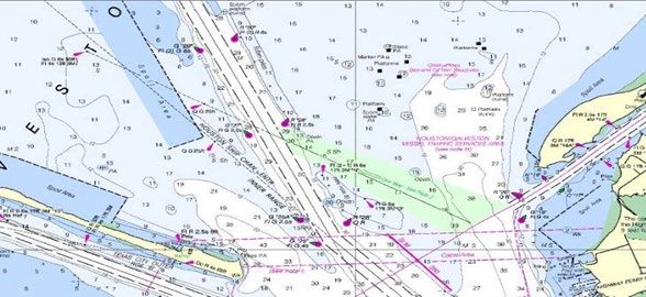
The Lone Star Harbor Safety Committee would like to thank the following people, organizations,
and companies for their contribution to this Mariner Guide Navigating the Houston-Galveston
Area Waterways: Brazos Pilots, Captain Ron Galloway, Florida Marine, G & H Towing, GICA,
Kirby, Phillip Kropf, Houston Pilots, Port of Houston Authority, Shell, The ACTion group and the
U.S. Coast Guard.

                          Lone Star Harbor Safety Committee
                                  4400 Hwy 225 E, Suite 200
                                    Deer Park, TX 77536
                                       (713) 678-4300

                                      lonestarhsc.org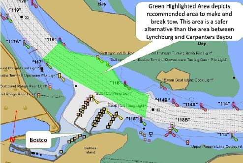
Table of Contents
1. Introduction, References, and Disclaimer......................................................... 5
2. Vessel Traffic Service Houston-Galveston...........................................................6
   A. Requests ............................................................................................................ 6
        I. Obstruction Requests .................................................................................6
        II. Special Traffic Management Request(STMR)...............................................7
3. Dredging............................................................................................................7
4. Bunkering..........................................................................................................8
5. Weather Conditions...........................................................................................9
   A. Heavy Weather...................................................................................................9
   B. Reduced Visibility..............................................................................................10
6. Port Restoration .............................................................................................11
7. Harbor Tugs....................................................................................................11
8. U.S. Coast Guard..............................................................................................11
   A. Aids to Navigation (ATON) Reporting...............................................................11
   B. USCG Maritime Security (MARSEC) Levels........................................................12
   C. Federal Security Zones ....................................................................................12
9. Sharing Our Bay with Non-VTS Users...............................................................13
   A. Information for Recreational Boaters...............................................................13
   B. Commercial Fishermen Information for All Vessels..........................................14
   C. Recreational Boater Information for All Vessels...............................................15

10. Region-Specific Information ..........................................................................16
    A. Bolivar Roads/Texas City (Y) ..........................................................................16
        I. Bolivar Roads Inbound Route (BRIR).........................................................16
        II. Bolivar Roads Anchorages........................................................................16
        III. Mooring Bouys..........................................................................................17
   B. Houston Ship Channel.................................................................................17
        I. Deepdraft/Inland Tow Interaction.............................................................18
        II. Understanding Hydrodynamics..................................................................19
        III. Bridges.......................................................................................................20
        IV. Mooring.....................................................................................................21
        V. Area Specific Guidance..............................................................................21
    C. San Jacinto River .............................................................................................22
        I. High Water Awareness..............................................................................22
        II. River Restrictions.......................................................................................23
    D. Port Freeport ..................................................................................................23
        I. Communications........................................................................................24
        II. Fleeting Areas ...........................................................................................24
        III. Area Specific Guidance..............................................................................24

                                            lonestarhsc.org                                                                     3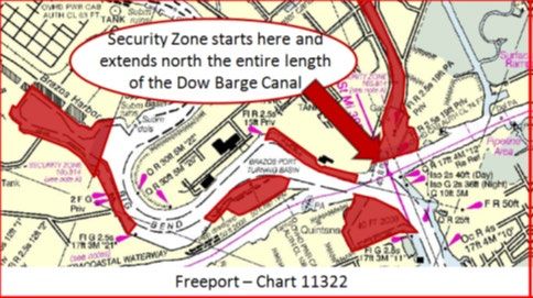
E. Gulf Intercoastal Waterway (GIWW) & Tributaries - (Mile 365.5 to 441.5)...24
              I. Pelican Island Bridge and Galveston Y - (Mile 365.5) ............................24
              II. Galveston Causeway / Railroad Bridge – (Mile 367.3)............................25
              III. Chocolate Moorings - (Mile 374.2).........................................................26
              IV. Chocolate Bayou - (Mile 376)..................................................................26
              V. Freeport Wiggles (Mile 392 to 393.8).....................................................26
              VI. Surfside Bridge - (Mile 394.9)................................................................27
              VII. Freeport Ship Channel Intersection - (Mile 395)....................................27
              VIII. Bryan Beach Bridge - (Mile 397.6)..........................................................27
              IX. Brazos River Floodgates - (Mile 400.4) ..................................................28
              X. San Bernard River - (Mile 405)...............................................................28
              Xl. Caney Creek (Sargent) Swing Bridge - (Mile 418)...................................29
              XII. Matagorda Bridge - (Mile 440.8) ...........................................................30
              XIII. Colorado River Locks - Mile 441 to 441.5).............................................30

    11)   Quick Reference Guide to Websites and Contact Numbers...............................31

4                                  Mariner Guide Navigating the Houston-Galveston Area Waterways
1.     Introduction
This guide is intended to assist mariners transiting the Houston-Galveston Area waterways with a focus on
commercial mariners (brownwater, bluewater, commercial fishermen, and dredge operators); however,
information in this document can be valuable to all mariners intending to transit these waterways,
including recreational boaters. Vessels and the waterways on which they operate represent a dynamic,
ever-changing environment. It is intended to share mariner experiences in the form of guidelines to
reduce risk and to better facilitate safe and efficient navigation. This document is not intended to cover
every possible scenario on the waterways.

The U.S. Coast Guard (USCG) can implement various traffic schemes to alleviate traffic concerns or
following a waterway closure. The USCG will initiate a broadcast notice to mariners advising mariners of
the implemented traffic schemes.

Every vessel type transiting our waterways has its own unique navigational challenges and limitations.
To maintain a safe environment, it is important to understand the waterway challenges, the differences
between vessel types, and how your operations impact others on the waterway. The Houston Area
Brownwater-Bluewater Coordination Seminar was developed to help address these challenges. The
Seminar creates a facilitated dialogue between the professionals who work on the water in Houston. The
goal of the seminar is to improve communication, trust, general knowledge regarding the capabilities and
limitations of the different vessels using the waterway, leading to the identification and implementation
of solutions to the opportunities identified. A link to the seminar can be found at the Lone Star Harbor
Safety Committee (Lone Star) web page (lonestarhsc.org).

This guide covers areas served by Lone Star Harbor Safety Committee, including the ports of Houston,
Galveston, Texas City, and Freeport, and the associated waterways of the Gulf Intracoastal Waterway
(GIWW) from mile markers 319 to 441 and its tributaries. All vertical clearances referenced in this
document (i.e. bridges) are in feet above mean high water (MHW) unless otherwise stated. All depths
referenced in this document are in feet below mean lower low water (MLLW) unless otherwise stated.
All navigation information in this guide is for reference only. Always consult the current Navigation Charts
for up-to-date information.

References:
(a) Navigation Regulations 33 C.F.R. § 207
(b) All waterways tributary to the Gulf of Mexico 33 C.F.R. § 207.180
(c) Ports and Waterways Safety 33 C.F.R. § 160
(d) Vessel Traffic Management 33 C.F.R. § 161

Disclaimer:
This document in no way diminishes or removes authority from any agency listed herein. All agencies
retain their full authority to modify the actions listed in accordance with their policies, procedures, and
Federal Regulations.

                                                  lonestarhsc.org                                              5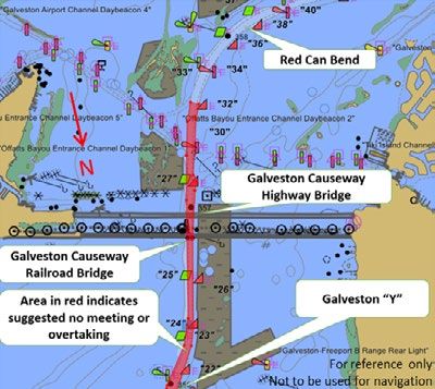
2.     Vessel Traffic Service Houston-Galveston

    The USCG operates a mandatory Vessel Traffic Service (VTS) system in the Houston, Galveston, and Texas
    City waterways. Vessels greater than 131 feet in length, vessels greater than 26 feet in length while
    engaged in towing, and vessels certificated to carry 50 or more passengers, while engaged in trade are
    required to participate. The VTS Houston/Galveston’s call sign is “Houston Traffic.”

    All captains and pilots are required to use their vessel’s official name when calling the VTS. Houston
    and Galveston-Texas City Pilots may use their individual identification number in addition to the vessel’s
    name. All communications must be in English. Mariners should utilize the VTS Users Guide located on
    the USCG Homeport web page (VTS Houston-Galveston User Guides) for reporting points, operating
    procedures and a complete list of designated radiotelephone frequencies.

    *VTS Users must maintain a listening watch on VHF Bride-to-Bridge (Ch 13) and the Designated VTS
    Frequency

    Greater Galveston Bay VHF-FM Channel Usage:
     VHF Channel     Use
           5A        VTS Houston-Galveston Sailing Plans
            9        Kirby Fleeting Area – Old River
           10        Channel Shipyard – San Jacinto River Tow Traffic
           11        VTS Houston-Galveston Sector II (HSC LT 33/34 to LT 121/122)
           12        VTS Houston-Galveston Sector I (Below HSC LT 33/34)
           13        Bridge-to-Bridge Radiotelephone
           14        Port Operations and Ship-to-Tug; Pilot Boats
           16        International Distress and Calling
           19        ExxonMobil Docks - Baytown
          21A        VTS Houston-Galveston Sector III (Above HSC LT 121/122)
          22A        Government/non-Government Liaison
      68/69/72/78 Recreational Boaters
           71        Commercial Shrimpers North of Texas City Dike and in the Midbay Area
           73        Galveston-Texas City Pilots Working
           74        Houston Pilots Working
         81/83       USCG Working
           88        Commercial Shrimpers in the Texas City channel and Galveston Harbor

    Be aware that there are ferries at Bolivar and Lynchburg.

    A.     Requests
    l.     Obstruction Requests
           Anyone proposing to conduct maritime operations that may interrupt or impede navigation on
           a shipping channel within the Captain of the Port Zone Houston-Galveston area of responsibility
           must submit a channel obstruction application. A link providing drop-down menus is available at:
           VTSA Channel Obstruction Request.

6                              Mariner Guide Navigating the Houston-Galveston Area Waterways
Requests are categorized by location (within or beyond the VTS Area) and by the category
       (magnitude) of the planned channel obstruction. Applicants should review these categories
       carefully prior to submitting an application. When submitted, the request is “socialized” to a
       broad population of maritime stakeholders and agencies.

       Category I Obstructions
       Include those operations impacting (or potentially impacting) navigation which cannot be
       completely mitigated by unilateral traffic management measures imposed by the Coast Guard.
       Complete or near-complete channel closures, or significant restrictions of meeting or overtaking
       situations, or dredging pipeline constriction, power line placement, dead ship movements,
       or large off-shore rig movements are examples of Category I obstructions. The Captain of the
       Port (COTP) requires four days (five days if the period covers a weekend) advance notice for
       consideration of a Category I obstruction.

       Category II Obstructions
       Include operations not completely limited to the boundaries of the channel, and with marginal
       effect on vessel navigation. Heavy-lift operations, roll-on/roll-off evolutions, and most off-shore
       rig movements are examples. Category II obstructions are typically short duration, short notice
       undertakings, and must be movable or terminable within one hour of notification from the VTS
       or COTP. The COTP requires twenty-four hours advance notice for consideration of a Category II
       obstruction.

ll.    Special Traffic Management Request (STMR)
       There are certain ships which transit the upper reaches of the Houston Ship Channel, (above Shell
       Deer Park), which because of their purpose, design or cargo are significantly restricted in their
       maneuverability and/or close-quarters visibility. These types of ships may include car carriers,
       project bulk, (windmill turbine cylinders, cross-deck gantry cranes), or other special needs.

       In cooperation with industry, VTS developed a Request for Special Traffic Management process
       which allows advanced notification and planning to provide an agreed upon “window” for their
       transits of these types of ships. To provide sufficient coordination, agents shall submit their
       request at least twelve (12) hours in advance of the planned transit. A Request for Special Traffic
       Management can be submitted at Request for Special Traffic Management.

3.     Dredging
You will find multiple dredges working within the COTP Zone at any given time. It is important to be
aware of dredge operations and understand their signals to avoid an accident.

During the day, dredges will display a ball-diamond-ball in a vertical line, usually on the centerline
near the forward portion of the dredge. This signals that you are approaching a vessel with limited
maneuverability. The “safe side” will be marked with two diamonds. Avoid the “danger side” marked
with two black balls. It is the side on which the dredge pipe is connected.

At night, the ball-diamond-ball pattern is replaced with a red over-white over-red pattern; the two
diamonds of the safe side by two vertical green lights; and the two black balls of the danger side by two
vertical red lights. Do not confuse these with navigation lights, and never pass a dredge until you confirm
passing arrangements with the dredge master on VHF-FM Channel 13.

                                                  lonestarhsc.org                                             7
Dredge operations involve a considerable number of support vessels that are necessary to move the
    dredge, relocate anchors and anchor balls, place dredging pipe and connecting flanges, and ferry
    personnel and supplies. These boats are on the move 24 hours a day. Maintain a close look-out and be
    prepared for sudden maneuvers by support vessels. The mariner is responsible for communicating with
    the dredge and making proper passing arrangements in accordance with the Rules of the Road.

    Any dredge operations that may interrupt or impede navigation on a shipping channel within the
    Captain of the Port Zone Houston-Galveston area of responsibility must submit the appropriate channel
    obstruction request at VTSA Channel Obstruction Requests.

    4.     Bunkering
    VTS has developed policies to reduce the risks associated with bunkering operations by moored vessels
    at critical locations in the VTSA.

    The mariner is responsible for ensuring vessels comply with Inland Waterway Navigation Regulations,
    specifically that "a clear channel shall at all times be left open to permit free and unobstructed navigation
    by all types of vessels and tows normally using the various waterways ...". VTS has determined that the
    indiscriminate mooring of vessels alongside already moored vessels or the doubling up of vessels at
    channel side facilities along the ship channel may constrict the navigable waterway to a hazardous level.
    Restrictions on breasting vessels and conducting transfer operations at specific locations on the channel
    are established where narrow channel widths and sharp bends make such restrictions necessary to
    permit safe navigation. The mariner is responsible for complying with directives concerning operations
    that constrict navigable waterways.

    A listing of restricted mooring locations and associated requirements can be found at Restricted Mooring
    and Lightering Locations.

    Bunkering at Bolivar Roads
    The Bolivar Roads anchorages are generally a safe place for ships to anchor. However, wakes from passing
    deep-draft traffic can affect barge-to-ship bunkering operations. Every vessel passing the anchorages
    should respect the hazards associated with conducting bunkering operations alongside a ship.

    The master of the towing vessel is responsible for the conduct and safety of the vessel prior to, during,
    and at the end of bunkering operations. It is also important to be on the lookout always for passing
    traffic. Tow safety can be ensured by taking precautions and following operating procedures. Complete
    text is available at VTS Houston-Galveston Users Guides (click VTS User’s Manual).

8                               Mariner Guide Navigating the Houston-Galveston Area Waterways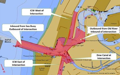
Bunkering Safety Guidelines:
   1) It is incumbent upon the master to check weather conditions – existing and forecasted – before
      departing for the bunkering operation. There should be adequate familiarity with the receiving
      vessel to ensure appropriate lines and fenders are prepared prior to departure.
   2) To ensure safety of the crew, to protect the vessel and the bunkering operation, and to prevent
      spills, the master should conduct a “pre-critical task conference” with the crew. At minimum, the
      master and crew should discuss:
            • Weather, tide, and current
            • Duration of the operation
            • Lookout procedures
            • Communications with the receiving ship
            • Definition of crewman responsibilities
            • Identification of situations that would require shutting down the transfer
            • The mooring plan, as well as potential placement of lines and fenders
   3) When possible, masters should plan to moor on the side of the vessel least affected by the
      wake effects of passing vessels. While alongside, both the master and crew should continuously
      monitor conditions – including passing traffic, shifting tides or winds, and changing weather. As
      conditions change, the master and crew should not hesitate to shift sides or stop the operation
      if it becomes hazardous.
4)    Prior to departing, the crew should ensure that all hoses, valves, and any equipment used in
      bunkering are secured and properly stowed. Following appropriate notifications, the towing
      vessel may depart for its next job.
5)    In accordance with 33 CFR 156.118, vessel operators must provide a 4-hour notice of anticipated
      bunkering operations to the Captain of the Port. This notice is required for all bunkering
      operations within the Bolivar Roads Anchorage, as defined by 33 CFR 110.197. Operators may
      make this notification to Houston Traffic via telephone at (281) 464-4837 (preferred) or VHF FM
      Channel 05A (alternate).

5.     Weather
A.     Heavy Weather
Heavy weather is any weather or natural activity that could negatively impact operations or navigation.
The typical heavy weather found in the region includes high winds, storms and hurricanes, flooding
and high currents, and extreme high or low water levels. VTS Houston-Galveston and other agencies
augment the inherent weather sensitivity of mariners with advisories and alerts to heavy weather.
Should weather conditions require restrictions on the waterways, VTS Houston-Galveston will broadcast
notices to mariners and inform the maritime industry.

Heavy weather amplifies the risks in our narrow waterways. While mariners are solely responsible for
the determination to continue a voyage, to seek a lay berth, or to go to anchor, the VTS may assist
in wheelhouse decision making. Early and effective communications are essential. A vessel electing to
anchor in any VTS-monitored waterway, for any reason, should make timely notification to "Houston
Traffic." The VTS will coordinate with other vessels in transit to safely close affected segments of the
waterway.

Recreational boaters should always exercise extreme caution in vicinity of ships and tows due to their
limited sightlines and maneuvering capabilities; especially so in conditions of hazardous weather and
restricted visibility.

Due to its proximity to the coast, the waterways covered in this guide may be heavily impacted by
hurricanes, and the US Coast Guard, the industry and other associated agencies have worked closely

                                                 lonestarhsc.org                                             9
together to develop detailed plans that address the closure of the ports/waterways prior to landfall and
     restoration after the storm passes. The latest USCG Heavy Weather Plan should be consulted ahead of
     hurricane season. A copy of the latest plan can be found at Sector Houston-Galveston Severe Weather
     Plan.

     In general, all capable sea-going vessels must make timely departure for open sea on the approach of
     a hurricane. Commercial self-propelled vessels greater than 500 gross tons and oceangoing Integrated
     towboat/barge combinations intending to remain in port will be required to submit a Declaration of
     Intent to Remain in Port and can be found at the USCG Homeport site under Local Contingency Plans
     Hurricane Forms / Declaration of Intent to Remain in Port

     Commercial vessels, including tug and barge tows should consider the hazards associated with heavy
     weather and if deemed appropriate, depart the area. If unable, they should seek alternative refuge
     by moving as far inland as possible and take shelter on the bayous and fleeting areas within the HSC.
     Special precautions should be taken for tows with certain dangerous cargoes (CDCs). General towing
     industry precautions ahead of a hurricane include:

        • Double or triple-mooring lines/wires on outboard sides of fleets.
        • Double or triple-mooring lines on piles or anchor points.
        • Develop a method to close off the fleet and secure all tiers in the fleet together to the extent
            possible.
        • Do not moor empty barges to docks, piers or facilities that have quay walls or wharf faces or
            other structures to prevent the empty barges from going over the top during surge or rapid rise
            in the waterway.
        • Ensure that the number of towboats available to monitor the fleet is adequate to assist in the
            event of a break-away.
        • During heavy weather, towboats should maintain an underway-equivalent watch when moored
            in a fleet.

     B.     Reduced Visibility
     Reduced visibility is another hazardous weather condition that mariners must be aware of, particularly
     when operating in narrow waterways and/or when other vessels are operating in close quarters.
     Hazardous weather conditions, particularly reduced visibility due to fog, can be localized and patchy
     at times, forming and moving in an unpredictable manner, and not always aligning with forecasts. The
     most accurate assessments of visibility come from the mariners operating along the waterway and
     combining that information with other data sources (i.e. forecasts, VTS, etc.).

     Our local waterways have limited availability of layberths, turning basins and anchorages, and any
     stoppage of a vessel in the navigable waterway has further effect on other traffic that might be moving
     toward the area of the stoppage. Deepsea vessels are limited to the deeper portions of the channel, and
     as such, must pre-plan actions when restricted visibility is a possibility. The pilots of these vessels are
     receiving information from weather forecasts, other mariners on the waterways (including other pilots
     in transit) and VTS. Pre-determined ship movement strategies are in place to address escalating risks
     of restricted visibility, including one-way traffic, counter-flow traffic with brownwater vessels, increased
     vessel separation, reduced speed, and anchoring in the channel (when not safe to continue).

     Mariners are encouraged to incorporate VTS advisories into their bridge management practices, utilizing
     the information that VTS provides to mariners in their wheelhouse decision-making. Early and effective
     communications are essential. A vessel electing to anchor in any VTS-monitored waterway, for any
     reason, should make timely notification to "Houston Traffic". The VTS will coordinate with other vessels
     in transit to safely close any affected segments of the waterway.

10                               Mariner Guide Navigating the Houston-Galveston Area Waterways
Recreational boaters should always exercise extreme caution in vicinity of ships and tows due to their
limited sightlines and maneuvering capabilities; especially so in conditions of hazardous weather and
restricted visibility.
6. Port Restoration
Any disruption of the normal heavy volume of traffic in the Greater Galveston Bay Port Complex creates
a significant backlog of vessels awaiting arrival or departure. Proven, standard procedures are in place to
ensure the orderly resumption of traffic and the maintenance of a safe operating environment. A major
closure is typically considered as one lasting, or likely to last, 24 hours or more, whether arising from
heavy weather, reduced visibility, a channel incident, an elevated MARSEC Condition, or other factors.
Mariners will be updated on restoration status via VHF Channels 13/16.
The Port Coordination Team (PCT) is among those processes. At its core, the PCT is a constituency-based
representative-driven information exchange. Information generated by the PCT informs COTP and
VTS Director decision-making in establishing priorities for waterway management. Among the traffic
management options are VTS Measures and Directives establishing one-way traffic schemes (e.g. piloted
ships outbound, inland towing vessels inbound for a specified period).
7. Harbor Tugs
Vessel berths along our waterways are numerous and varied, harbor tugs are powerful and maneuverable
vessels that may travel in any direction. When assisting ships, harbor tugs may or may not be made up to
the vessel with a line, but regardless it is imperative that you recognize the tug is assisting a vessel and
provide a wide berth for the operation – one minute the tug can be working against the vessel and the
next be stretched out on their lines. Additionally, tugs may be maneuvering around the vessel while they
assist with the berthing/ unberthing; they may suddenly move into sight as they move from the one side
of the vessel to the other very rapidly.
Tugs also produce very powerful propeller wash that may affect vessels passing in close proximity.
Harbor tugs have much deeper drafts than towboats and will usually be restricted to the deeper areas
of the channel. While assisting ships, the actions of the tugs are at the direction of a State Pilot or the
Ship’s Master. It is common practice that the Pilot will make a broadcast on channel 13 before they shift
to a working channel to direct the operation of the tugs. If needed, contact the Pilot on the operating
frequencies stated in the “Greater Galveston Bay VHF-FM Channel Usage” chart on page 6 of this
publication regarding the movement(s) of the vessel and/or tugs.
8. U.S. Coast Guard
A. Aids to Navigation (ATON) Reporting
Maintaining over 1100 ATONs is a major challenge and the high number of M allisions complicates
operations even more for the US Coast Guard’s Waterways Management Division and its four ATON units.
When aids are damaged or missing, navigation safety is jeopardized. Per 33CFR62.65, it is a mariner’s
legal obligation to report any incident involving damage to or destruction of an ATON. Failure to report
could result in severe penalties including fines and/or imprisonment, along with revocation and/or loss
of license as referenced in 33CFR66.01-45. However, even more significant, the damage or loss of an
ATON puts all other mariners in harm’s way. By reporting an ATON discrepancy immediately, the USCG’s
limited resources may be put to most efficient use, and risk to other mariners can be removed as quickly
as possible.
lonestarhsc.org 11ATON discrepancies should be made to the Sector Houston-Galveston Command Center at
(281) 464-4855/ VHF Channel 16 or Sector Houston-Galveston Vessel Traffic Service at (281)464-4837/
VHF Channels 05A, 11, 12, and 21A.
B. USCG Maritime Security (MARSEC) Levels
U.S. Coast Guard Maritime Security (MARSEC) Levels
The Coast Guard employs a three-tiered system of Maritime Security (MARSEC) Levels designed to easily
communicate to the Coast Guard and our maritime industry partners pre-planned scalable responses
for credible threats. MARSEC Levels are set to reflect the prevailing threat environment to the marine
elements of the national transportation system, including ports, vessels, facilities, and critical assets and
infrastructure located on or adjacent to waters subject to the jurisdiction of the U.S. MARSEC Levels
apply to vessels, Coast Guard-regulated facilities inside the U.S., and to the Coast Guard.
• MARSEC Level 1: The threat of an unlawful act against a terminal or vessel is, though possible,
not likely.
• MARSEC Level 2: An unlawful act against a vessel or terminal is possible, and intelligence
indicates that terrorists are likely to be active within a specific area, or against a type of vessel or
terminal.
• MARSEC Level 3: An unlawful act against a vessel or terminal is probable or imminent and
intelligence indicates that terrorists have chosen specific targets.
MARSEC Level 1 generally applies in the absence of a National Terrorism Advisory System (NTAS) Alert
or when the Commandant of the Coast Guard determines that the Alert is not applicable to the Marine
Transportation System. Any increase of MARSEC Level will be disseminated via broadcast notice to
mariners.
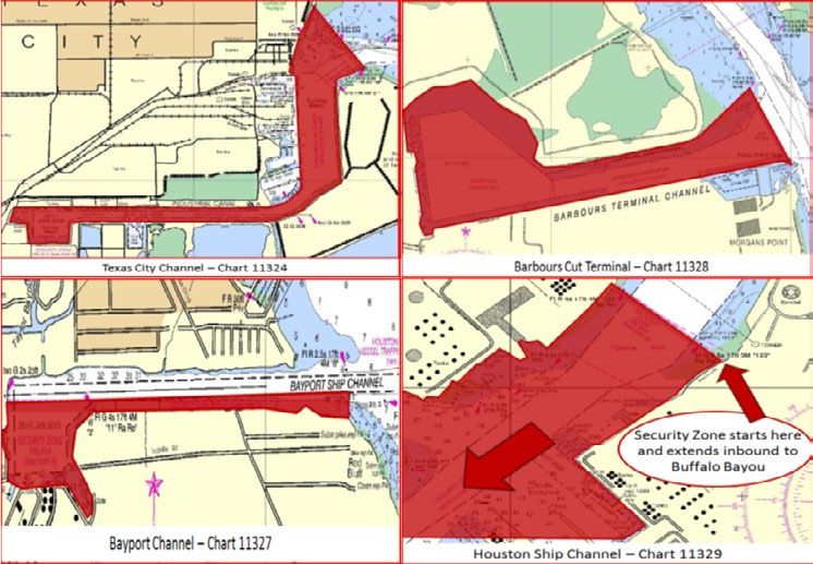
C. Federal Security Zones
12 Mariner Guide Navigating the Houston-Galveston Area WaterwaysThe COTP has
established Security
Zones for certain areas
within our waterways.
The most current
security regulations
should be consulted at
33 CFR 165.813, 33 CFR
165.814, and 33 CFR
165.818. In addition,
the US Coast Guard
may enact additional
and/or moving security
zones around certain
vessels when deemed
appropriate. However,
the below information
can be used as general
guidance.
The regulations noted
above identify which vessels are authorized to operate within the security zone without the need for a
permit. Recreational vessels, fishing vessels, and unauthorized vessels and persons are prohibited from
these areas without permission from the COTP. When entry into a security zone is desired by anyone
other than those authorized by the regulations, a request to enter the security zones must be made to
the Sector Houston-Galveston Waterways Management (WWM) Division at least five business days in
advance of the expected transit. Violators may be subject to civil penalties, fines, and/or imprisonment.
The security zones are identified above in red.
9. Sharing Our Bay with Non-VTS Users
A. Information needed for Recreational Boaters when interacting with commercial vessels in the
bay.
Sharing Galveston Bay with Commercial Mariners
The publication was developed in 2011 and maintained by the Lone Star
Harbor Safety Committee. It was designed to provide information to
recreational boaters on how to safely and intelligently, navigate in and
around the commercial navigation channels without interfering with
the ships, tows, and dredges, which are draft-restricted and otherwise
“privileged vessels”. The Sharing Our Bay publication can be accessed
from the Lone Star web site under the Recreational boaters resources
section at: Sharing Our Bay - Information for Recreational Boaters.
Professional mariners are also invited to look at it.
lonestarhsc.org 13The items covered in the document are:
• Challenges operating near commercial vessels
• Communications on the waterways (VHF, emergency phone numbers, and whistle signals)
• Navigation channels (using the barge lanes, boater cuts into Trinity Bay)
• Navigation Rules (Rule 9 and other area-specific information)
• Dredging (understanding “safe side” and “danger side”, dredge pipelines, support vessels)
The Sharing Our Bay stated: “The ship channel takes up less than 1% of Galveston Bay. The other 99% is
for the recreational boaters to enjoy. Together we can share Galveston Bay in a safe and environmentally
compatible manner.”
Even if you have a lot of boating experience, before you venture out on Galveston Bay, become familiar
with both the Navigation Rules and Sharing Our Bay. Protect your vessel, and more importantly, the life
of yourself and your crew, by reading and understanding this information.
B. Commercial Fishermen Information for all mariners when interacting with commercial fishing
vessels
Commercial Fishermen on Galveston Bay
Commercial fishing continues to be a significant industry in Texas. Galveston
Bay shrimpers work in a variety of locations around the Bay: on the west
side of the HSC off the San Leon coastline down to the Texas City Dike, all
over Trinity Bay (mostly the western portions), in the very lower portions
of the bay along the edges of the various channels located there, and in
Galveston Harbor. It is the mid-bay shrimping, where the boats tend to
migrate up and down the barge lanes on the edges of the deep HSC, which
have the most impact and interaction with other commercial traffic and
towboat traffic navigating those same barge lanes.
Shrimp Fishing
To prevent unsafe
situations, shrimp captains
request that overtaking
tows call a mile in advance
so that they have time
to move over or out of
the way completely after
picking up their nets. Note:
sometimes shrimp captains
do not answer VHF calls
immediately because they
14 Mariner Guide Navigating the Houston-Galveston Area Waterwaysare working their gear.
The following are the VHF working channels that shrimpers and oysters utilize when fishing in the
general Galveston Bay area:
Channel Use
71 Commercial shrimpers north of Texas City Dike and in the Mid-Bay area
78 Commercial oyster boats
88 Commercial shrimpers in Texas City channel and Galveston Harbor
Oyster Fishing
The local fleets of oyster boats sail out of either the San Leon area to the west of the HSC, or out of Smith
Point to the east of the HSC, and they fish whatever leases are open on either side of the HSC dividing
line. If they are ever in the HSC, it is merely to cross over to the other half of the bay, and so their impact
on other vessels navigating the HSC is relatively small.
C. Recreational Boater Information for All Vessels Information for all mariners when interacting with
recreational vessels
Sharing Galveston Bay with Recreational Boaters
If you are a professional mariner navigating a commercial vessel on
Galveston Bay, including the Houston Ship Channel, Galveston Harbor,
the GIWW, and any adjacent waters, this section is designed to provide
information on the numerous recreational boaters who are navigating
these waters. Most recreational boaters do not spend a lot of time inside
the shipping channels, but when you are sharing these waterways with
them it would be good to understand what you may encounter. This section
is an introduction to the full “Sharing Galveston Bay With Recreational
Boaters” document, which can be accessed from the Lone Star web site
under the Recreational Boaters Resources section at: Sharing Galveston Bay With Recreational Boaters.
Items covered in the document are:
• Where recreational boaters operate and where you might encounter them
• VHF usage by recreational boaters
• AIS usage by recreational boaters
• Whistle signals and VHF communications
• Local VHF terminology and making meeting/overtaking arrangements
• Dangerous situations that threaten recreational boaters
The Commercial Mariner is encouraged to review the “Sharing Our Bay” document that is described in
the section 9A and is written for Recreational Boaters.
lonestarhsc.org 1510. Region-Specific Information
A. Bolivar Roads/Texas City (Y)
I. Bolivar Roads Inbound Route (BRIR)
The Coast Guard has established a route for tows entering the Houston Ship Channel from the
GIWW at Bolivar. The route is highlighted on NOAA Chart 11324, lies in naturally deep water,
and is marked with a lighted 300˚ T-head range. Houston Traffic directs that vessels not using
this route so indicate when checking in. During periods of high traffic volume, preference may
be given to tows using the inbound route. All vessels should make a Security broadcast prior to
entering the Houston Ship Channel from the GIWW.
Outbound tows eastbound on the GIWW normally proceed south to HSC LT 26, then east to
Bolivar Point. With a strong ebb, it may be advisable for longer tows to drop down to the area
above the Bolivar Ferry landing while turning east, to stem the tide while making the Bolivar
Land Cut. Outbound use of the BRIR may be requested from “Houston Traffic” when traffic
permits. Outbound use of the BRIR may be directed when “Houston Traffic” has implemented
Traffic Management Procedures effecting one-way inbound ship traffic/one-way outbound tow
traffic. This enables tows headed East on the GIWW to cross to the red side when convenient,
rather than being constrained to cross inbound ships only at LT 26.”
Note: The Bolivar Roads Inbound Route is 1700 feet wide at its entrance (lower right), 730 feet
wide at its exit (upper left) and one nautical mile in length. Range lights assist with staying on
the centerline.
II. Bolivar Roads Anchorages
Anchorage areas at Bolivar Roads (see NOAA Chart 11324) are intended for temporary use by
vessels of all types. Most vessels use the Bolivar Roads Anchorages while waiting for dock space
to clear, for bad weather to pass, for bunkering and/or provisioning, or for completion of any
required inspections
16 Mariner Guide Navigating the Houston-Galveston Area WaterwaysMariners should note specific restrictions applicable
to Anchorage Areas A and C as set forth at 33 CFR
110.197:
• Unless otherwise authorized by the Captain of
the Port Sector Houston-Galveston, vessels shall
not anchor in Anchorage Area A or C for more
than 48 hours.
• No vessel with a draft of less than 22 feet may
occupy Anchorage Area A without prior approval
from the Captain of the Port.
• No vessel with a draft of less than 16 feet may
occupy Anchorage Area C without prior approval
from the Captain of the Port.
• Anchors shall not be placed in the navigation channel, and no portion of the hull or rigging of
any anchored vessel shall extend outside the anchorage areas.
VTS Houston-Galveston oversees the management of vessels within Bolivar Roads Anchorages.
lll. Mooring Buoys
Use of Bolivar and Pelican mooring buoys is limited to maximum 72 hours, unless weather
prevents movements. No unattended barges are permitted. Along the GIWW near Bolivar Roads
and Pelican Island, vessel traffic can become congested. Whenever necessary, the USCG will
then establish temporary VTS reporting points, and the USCG will initiate a broadcast notice to
mariners advising mariners of the congestion and the temporary VTS reporting points.
B. Houston Ship Channel
The Houston Ship Channel is one of the busiest and most challenging waterways in the world. On an
average day, the Houston Ship Channel has more than 60 ships and 400 barge movements. Project width
and depth vary along the HSC between the Galveston Entrance to the upper turning basin, as follows:
• Galveston Entrance to Boggy Bayou – 530’x46.5’ with designated barge lanes below Morgans
Point. The channel width in the vicinity of Cargill narrows to 400’.
• Boggy Bayou to SP Slip (near the I-610 bridge) – 300’x41.5’
• SP Slip to Upper Turning Basin – less than 300’x37.5’, with many berth pockets adjacent to
the main federal channel
Below Morgans Point, the HSC is equipped with designated barge lanes on either side of the deep-water
channel. The barge lanes permit the safe movement of larger volumes of mixed-use vessel traffic. Tow
operators are encouraged to use the barge lanes as a safe navigation space, leaving the main channel
free for faster moving vessels and deep-draft ships. While the barge lanes provide space between ships
and tows, operators should be aware of hydrodynamic effects caused by the channel configuration.
Currents in the barge lanes may run slightly faster due to their shallower depth, and forces exerted by
larger displacement ships will be amplified. A cross section of the HSC below Morgans Point shows:
• A main deep draft vessel channel dredged to a project depth of 46.5 feet and width of
530 feet;
• 35-foot wide transition slopes on either side of the main channel, measuring 46.5 feet deep
at their innermost point, and a minimum of 12 feet deep at their outermost point;
• 200 feet wide barge lanes outside the transition slopes, measuring a minimum of 12 feet
lonestarhsc.org 17deep; and,
• Width of the entire channel along this reach as 1000 feet between beacons.
l. Deep Draft/Inland Tow Interaction
The configuration and cargo of a ship may affect the vessel operator’s line of sight from the ship’s
bridge. The blind spot ahead of the bow can range from a few hundred feet to a few thousand
feet in the case of deep draft container ships. Cranes, containers, and cargo canopies can create
additional blind spots. Towboat and other vessel operators should exercise extreme caution
when attempting to overtake or meet a ship especially in the upper ship channel, taking care
to avoid blind spots and to communicate intentions when necessary.
DANGER ZONE
Vessels as large as neo-panamax container vessels (1160’x150’) and suezmax tankers (950’x165’)
regularly transit the HSC. The sheer size of these vessels leads to amplification of hydraulic forces
exerted on other vessels in the vicinity, especially tow vessels and barges.
18 Mariner Guide Navigating the Houston-Galveston Area WaterwaysVessel Size Comparison
Aframax
Length: 830 ft
Beam: 145 ft
Draft: 45 ft
Suezmax
Length: 920 ft
Beam: 165 ft
Draft: 45 ft
Empire State Building
Height: 1250 ft
Neo-Panamax
Length: 1160 ft
Beam: 150’
Draft: 45’
II. Understanding Hydrodynamics
A moving ship pushes water away from its hull in all directions. As the ship moves forward, water
will flow around and under the vessel to fill space in its wake. Areas of high pressure exist on
both sides of the moving ship’s bow as water is displaced. As it flows along the sides of the ship,
water speed increases until it reaches an area of low pressure near the stern. This is where “ship’s
suction” occurs. Ship’s suction is a hydraulic effect that draws neighboring vessels toward the
stern as the ship passes or pulls the stern towards the toe of the channel when transiting near
the channel’s edge.
Water Flow Around a Moving Ship
Low Pressure
High Pressure
lonestarhsc.org 19When two ships meet in the Channel, this effect can turn each of them off-course in a counter-
clockwise direction (assuming opposing vessels are both on their respective right sides of the
Channel). This poses potential danger to vessels following either ship. To avoid this hazard,
vessels should maintain following distances large enough to permit meeting ships to correct their
course.
The effect of ship's suction of passing vessels can jeopardize
those following too closely
In similar fashion, a ship exerts suction on vessels it overtakes in the Channel. To mitigate the
effect, tow operators are encouraged to position their vessels at an angle to the ship’s path (with
the stern pointing toward the ship and the bow pointing away from the ship). Hydraulic effects on
moored vessels are also amplified by the presence of larger ships in the Houston Ship Channel.
Please see the section on Mooring Issues for tips on mitigating these effects.
A tow prepares to be overtaken by a ship in the channel.
lll. Bridges
20 Mariner Guide Navigating the Houston-Galveston Area WaterwaysIV. Mooring
As a passing ship approaches, the water surge ahead of it will cause a water flow at the pier in
the direction of the passing ship. As the ship passes, water flow at the berth will shift direction,
drawing the moored vessel in the opposite direction. A third force comes into play as the stern
of the vessel passes. This force follows the passing vessel and is diametrically opposed to the
previous force. In a short period, the moored vessel will be pushed in different directions three
times.
Because these forces are amplified by the transit of larger ships, it is particularly important to pay
attention to proper dockside moorings. Mariners should tend their lines carefully and make sure
loads are equally distributed. Lines should be tensioned such that no movement is allowed at the
dock. If slack lines permit movement of even a few feet, the moored vessel will be subjected to a
substantial amount of energy that will surge loads and part overloaded mooring lines.
The Lone Star Harbor Safety Committee includes a sub-committee whose purpose is to address
issues related to mooring safety along our waterways. This group is working with the USCG to
reduce incidents of parted mooring lines and damaged moorings. They are accomplishing this
goal by educating mariners and dockhands on the importance of proper mooring leads, adequate
mooring lines and optimal use of cleats and bitts. In furtherance of navigation safety, the pilots
report vessels with slack mooring lines to VTS.
V. Area Specific Guidance
1) Bolivar Roads to Barbours Cut: The Bolivar Roads Inbound Route (BRIR) is designed to
allow westbound traffic exiting Bolivar Roads to easily enter the HSC rather than navigating
the 105-degree turn at the intersection. (See Section 10A for more information).
2) Barbours Cut to Baytown: Tows and barges should not transit beyond the GIWW without
confirmation of available fleeting area space or dock space. Beyond Baytown, traffic density
increases considerably, especially near Lynchburg. Turning around (topping around) due
to lack of fleet space unnecessarily increases navigation safety risk.
3) Baytown to Boggy Bayou (Shell): The area of Bostco turning basin is a recommended area for
tows looking to double up or string out tow on the fly. This area is a better alternative than
from the Lynchburg ferry to Carpenters Bayou due to a high density of tow and ship traffic.
4) Lynchburg to Boggy Bayou (Shell): It is recommended that no overtaking should be conducted
in waterways within this area to include
the San Jacinto River.
5) Buffalo Bayou: When currents exceed
3 knots in the main stem of the Houston
Ship Channel anywhere above Lynchburg,
VTS will likely impose additional waterway
restrictions via VTS Measures. Firsthand
reports from mariners are augmented by
monitoring a USGS flow meter at Piney
Point (west Houston). When flow rates at
this meter reach 15000 cubic ft/sec, the
VTS may implement a Measure restricting
vessel movements north of the Buffalo
Bayou Turning Basin/above the Railway
Bridge.
lonestarhsc.org 21C San Jacinto River
I. High Water Awareness
The Upper San Jacinto River and Buffalo Bayou basins include multiple watersheds draining nearly
3300 square miles of land in urban and developed areas. Heavy rainfalls arising from stalled
frontal systems, long periods of excessive rainfall, or heavy weather can lead to remarkable runoffs
having direct and substantial impacts upon San Jacinto River and Upper Houston Ship Channel,
producing high water and/or strong currents in the waterways of VTS Houston-Galveston’s VTSA.
These situations may trigger special management protocols. VTS Houston-Galveston protocols
are guided by a High Water Action Plan developed under COTP Houston-Galveston guidance. The
VTS Houston Galveston High Water Action Plan consists of three phases:
• Watch Phase
• Action Phase
• Recovery Phase
Watch Phase:
• VTS and other USCG activities monitor the United States Geological Survey (USGS) site “San
Jacinto River near Sheldon,” also known as the Highway 90 bridge site. Closer monitoring
begins with the potential for high water conditions. The Watch Phase is triggered at six
(6) feet on the Sheldon Gauge.
• During the Watch Phase, VTS evaluates underlying conditions and randomly queries VTS
users in the area to gauge the impact on vessels. VTS also initiates a broadcast advising
mariners of the high water on the San Jacinto River and the possibility of strong currents in
the Houston Ship Channel near the mouth of the San Jacinto River and area bayous.
Action Phase:
• The Action Phase is initiated at eight (8) feet on the Sheldon Gauge. Active traffic control
and continuous information coordination between the USCG and the various waterway
stakeholders are supported by the extension of Houston Traffic’s VTSA to, and the activation
of a temporary reporting point at the Interstate-10 San Jacinto Causeway.
• When the Sheldon Gauge reaches ten (10) feet, restrictive traffic measures will be
implemented by VTS Measures and appropriate paralleling broadcasts.
• Additional traffic measures may be applied to Houston Ship Channel at and below the mouth
of the San Jacinto River (generally between HSC beacons 124 and 132). These measures may
include prohibiting meeting or overtaking in a specified reach
• When the Sheldon Gauge reaches twelve (12) feet, VTS Measures are extended to cover 1000
yards above and below the Causeway.
• At fourteen (14) feet on the Sheldon Gauge, additional measures may be imposed on the
Lower San Jacinto River and the Houston Ship Channel.
Recovery Phase:
Relaxation of Action Phase restrictions will generally mirror the Imposition Thresholds for rising
water with additional actions as informed by any necessary channel surveys and an assessment
of Aids to Navigation and any emergent pollution fields. (See Port Restoration Section).
22 Mariner Guide Navigating the Houston-Galveston Area WaterwaysII. River Restrictions
The USCG has observed and received repeated
complaints of unsafe conditions near the Mud Bank
in the San Jacinto River. Sector Houston-Galveston
has determined, per 33 CFR 64.06, that current
practices by some waterway users present a hazard
to navigation.
The following operating restrictions are in place:
• Only towboats with barges in tow are permitted
on the Mud Bank. No unattended or shared
barges are authorized on the Mud Bank.
• The only towboats, barges and tows permitted on
the Mud Bank are those awaiting fleet space or
dock space.
• Towboats, barges and tows that make use of the
Mud Bank are limited to no more than 48 consecutive
hours and shall not exceed this timeframe.
• Towboats, barges and tows using the Mud Bank shall not extend into the San Jacinto
River beyond 162 feet from the riverbank. (No Exceptions).
• The area from the mouth of the San Jacinto River across from Channel Shipyard is
restricted. Tows should not land or push up in this area. This area also has
unprotected highline structures.
The mariner is advised to follow the best practices below:
• Vessels should orient their tows as close to bank as practical.
• Vessels should standby on VHF Channels 10/16
• Vessels must be mindful of their wheel wash and its impact on adjacent marine traffic
Waterway users who fail to comply with the above operating restrictions may be subject to
regulatory and administrative action. Persistent disregard of these operating restrictions may
result in closure of the San Jacinto River Mud Bank to all tows.
D. Port Freeport
Port Freeport is a growing port, and with growth comes increased traffic. Many vessels share this
waterway from pleasure craft to large commercial vessels. The waterway includes the Freeport Ship
Channel from the “FP” Buoy to the Stauffer Turning Basin, and the GIWW from Surfside Bridge to Bryan
Beach Bridge. Approximately 900-950 commercial vessels call on Freeport and thousands of tug and
barges transit the waterway annually.
The Brazos Pilots Association serves this waterway including all ports of Brazoria County. At this time,
the Brazos Pilot Station is unmanned and is unable to be reached 24/7 by VHF Radio. The Pilots can
be reached on VHF Channel 14/16 from 9am-5pm Mon-Fri and any time the Pilot Boat is underway
or when the Pilots are moving a vessel on the channel. The Pilots work exclusively on VHF Channel
14/16 while maneuvering and coordinating traffic. This channel is not to be used by recreational boat
operators or as a working channel for any other commercial operations not pertaining to the movement
of a vessel within the Freeport Ship Channel. The Brazos Pilots Association advise all mariners transiting
the Freeport Ship Channel and its intersection with the GIWW to not impede the movement of any
vessels under pilotage. The Freeport Ship Channel is a very narrow waterway with small margins for
error. The Brazos Pilots maintain one of the best safety records in all of Texas and want to keep it that
way.
lonestarhsc.org 23I. Communications
Vessels calling on or transiting Freeport are advised to make security calls at the following
locations:
a) Inbound at the end of the Freeport Jetties for traffic at the intersection of the
Freeport Channel with the GIWW
b) Westbound at Surfside Bridge
c) Eastbound at Bryan Beach Bridge (FM 1495 Bridge)
d) Inbound at the beacon number 10 for Old River Traffic
e) Outbound before getting underway inside of the Old River
f) Outbound after exiting Phillips Bend for traffic at the intersection of the Freeport
Channel with the GIWW
II. Fleeting Area
a) A fleeting area is established above the Upper Turning Basin in the harbor. The tug and
barge fleet operate primarily on VHF Channel 10. Prior to departing, tug and barge
traffic is urged to make a security call on VHF Channel 16 alerting other vessels operating
to their operation and intentions.
III. Area Specific Guidance
a) Freeport Ship Channel at Intersection with GIWW – All vessels need to be aware that
large commercial vessels calling on the port of Freeport use this intersection space
to make wide turns inbound and outbound. Vessels transiting the area need to aware
not to impede the safe passage of large vessels under pilotage.
b) Brazosport Turning Basin to Jetty Channel - This section of Freeport Ship Channel is only
400 ft wide. It is a narrow section of the channel to meet oncoming vessels.
c) Phillips Bend – Meeting other vessels in Phillips Bend is extremely dangerous. The turn
requires a 117-degree turn. Judging safe passing is difficult when it is not possible at
times to see vessels approaching from the other side of the bend. Security calls when
approaching this bend are recommended on VHF Channel16.
E. Gulf Intercoastal Waterway And Tributaries (Mile 365.5-441.5)
Gulf Intracoastal Canal Association (GICA) is a not-for-profit trade association whose mission is to
facilitate commerce through ensuring safe, reliable and efficient GIWW. For up-to-date information
regarding issues that affect the GIWW contact the GICA at the following link - Gulf Intracoastal Canal
Association.
I. Pelican Island Bridge and Galveston Y– Mile 365.5
The Pelican Island bridge is located at the
most inbound end of the Galveston harbor.
The bridge is a bascule type with 12.8 feet
closed vertical clearance and an open span
of 74.8 feet. The horizontal clearance is 120
feet. Vessels requiring more than 13 feet
clearance must know that the bridge (in the
raised position) DOES hang over the south
side of the channel and vessels should stay
to the north side of the channel for proper
clearance. The bridge tender must be
contacted on VHF channel 16 for transit
and mariners should carefully consider the strength of the tidal currents and wind before
24 Mariner Guide Navigating the Houston-Galveston Area Waterwayscommitting to making the bridge. NOAA chart 11324 (pg 17) identifies this route as the
“Intracoastal Waterway (Galveston-Freeport Cutoff)” (i.e. kind of an “alternate” route); however,
it is the “Intracoastal Waterway” route through Galveston Harbor that was the original GIWW
route. The channel from the Pelican Island bridge to the Galveston “Y” is used primarily for
commercial fishing vessels, recreational boaters, and is not generally used for tow traffic. The
Pelican Cut (mile 351.7) is maintained by the USACE, and thus most mariners traveling the GIWW
between the Port Bolivar area and the Galveston Causeway and points west take the route
through Pelican Cut. When entering the GIWW, mariners should consider other commercial
traffic approaching the “Y” and traffic transiting the Causeway bridge.
A document (originally created for recreational boaters) that describes in some detail the physical
characteristics of the bridge, photos, vertical clearances, and the curfew hours when the bridge
is closed to marine traffic is available from the Lone Star website under the recreational boaters
resources section at: Pelican Island Bridge - Info for Recreational Boaters.
II. Galveston Causeway/Railroad Bridge – Mile 367.3
The Galveston Causeway Bridges (I-45 Highway and
BNSF Railroad Bridge) are located at mile board
357.2 on the Intracoastal Waterway. The Galveston
Causeway highway bridge (I-45) is a fixed bridge with
clearances of 310 feet x 72.8 feet. The railroad bridge
clearance is 7.75 feet when down, and lifted clearance is 72.8 feet, with a horizontal clearance of
300 feet. The bridge tender is contacted on VHF channel 16 and will go to channel 10 for a working
frequency. Vessels approaching from the west should contact the bridge at Bird Island. Vessels
approaching from the east should call the tender at the Galveston “Y”. Vessels should monitor
channel 16 for notices that the railroad bridge is being lowered and should plan accordingly for
possible delays in raising the bridge. Vessels should carefully consider the tide direction, speed
of current, wind, commercial, and recreational traffic in the area before committing to the bridge
transit.
lonestarhsc.org 25You can also read