Overton Parish Biodiversity Action Plan - 2015 to 2019 - Overton Biodiversity Society
←
→
Page content transcription
If your browser does not render page correctly, please read the page content below
Overton Parish
Biodiversity Action Plan
               2015 to 2019

  Copyright © Overton Biodiversity Society 2015
          www.overton-biodiversity.org

                        1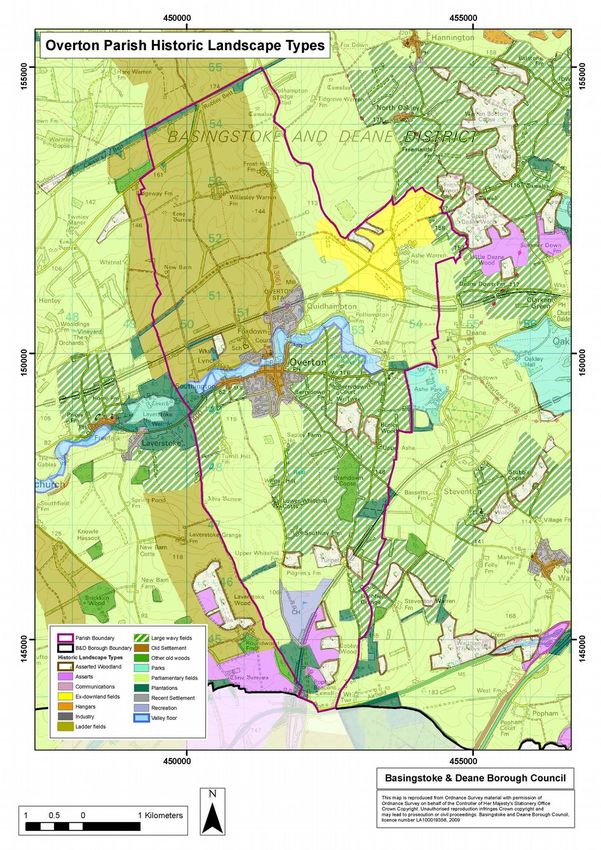
Contents

Foreword..............................................................................................................4
Introduction.........................................................................................................4
Acknowledgements.............................................................................................4
A Parish Plan for Biodiversity............................................................................5
The Parish of Overton.........................................................................................7
   Location.............................................................................................................7
   Geology and Soil...............................................................................................9
   Climate and Hydrology......................................................................................9
   Topography......................................................................................................10
   Landscape History and Archaeology...............................................................11
   Landscape Character Areas............................................................................12
Habitat Types.....................................................................................................17
   Lowland Mixed Deciduous Woodland.............................................................17
   Open Standing Water / Ponds.........................................................................18
   Lowland Wet Grassland...................................................................................18
   Chalk Rivers....................................................................................................18
   Wood Pasture and Parkland............................................................................19
   Arable Field Margins........................................................................................19
   Hedgerows.......................................................................................................19
   Lowland Calcareous Grassland.......................................................................20
   Spoil Heaps.....................................................................................................20
   Improved Grassland........................................................................................21
   Other land use.................................................................................................21
Nature Conservation Sites in Overton............................................................23
   Sites of Special Scientific Interest...................................................................23
   Sites of Importance for Nature Conservation (SINCs)....................................25
Species...............................................................................................................26
   Water vole........................................................................................................26
   Common Dormouse.........................................................................................27
   Kingfisher.........................................................................................................27
   Farmland Birds................................................................................................27
   Black Poplar.....................................................................................................28
   Bluebell............................................................................................................28
   Glow worm.......................................................................................................29
   Butterflies and Moths.......................................................................................29

                                                           2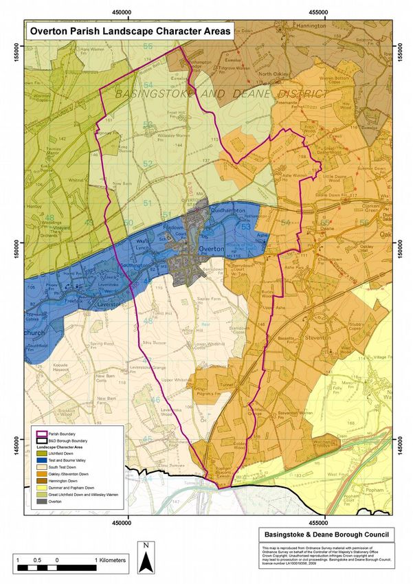
Overton Biodiversity Action Plan....................................................................30
   Developing the new Action Plan......................................................................30
   The Action Plan 2015-2019.............................................................................31
References.........................................................................................................33
Abbreviations ...................................................................................................34
Appendices........................................................................................................34
   Appendix 1 – Soils of Overton.........................................................................35
   Appendix 2 – Overton Parish Historic Landscape Types................................36
   Appendix 3 – Overton Parish Landscape Character Areas............................37
   Appendix 4 – Statutory and Non-Statutory Designated Sites within Overton
   Parish...............................................................................................................38
   Appendix 5 – HBIC comments on SINCs and other sites of interest..............39
   Appendix 6 – Overton Parish Phase 1 (main) Habitat types...........................50

                                                           3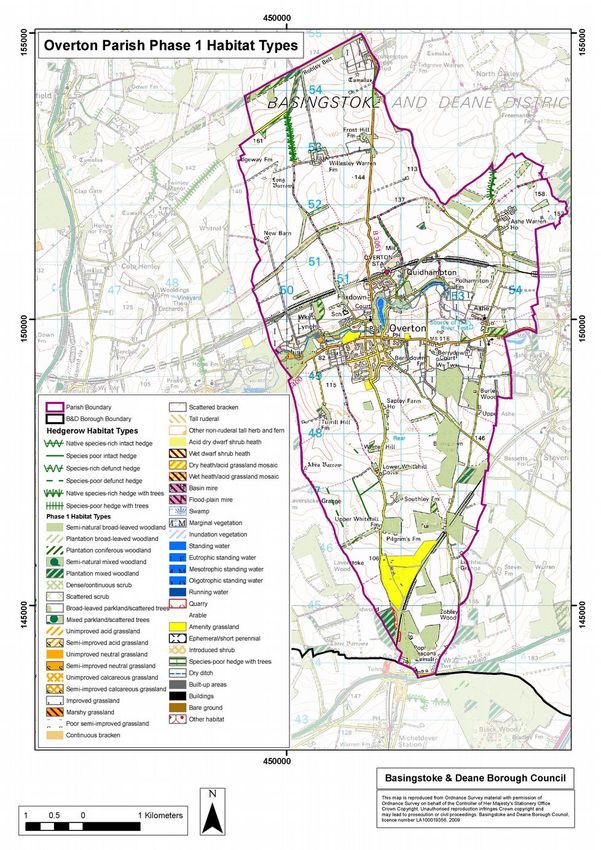
Foreword
Welcome to Overton Biodiversity Society’s Parish Biodiversity Action Plan for
2015 to 2020.
This builds upon the first Overton Biodiversity Action Plan (2009 – 2014) which
was produced by Overton Biodiversity Society with assistance from Hampshire
and Isle of Wight Wildlife Trust, Overton Parish Council and Basingstoke and
Deane Borough Council.
I hope you enjoy reading it and that the actions and targets set out in it will help
the local community to protect and enhance the wildlife heritage of the parish of
Overton.

Alison Cross
Area Head of Conservation (North & East Hampshire)

Introduction
Overton Parish comprises a wide range of wildlife habitats and species which
contribute to its biological, economic and social well-being. The village’s wildlife
areas are coming under increasing pressures from climate change,
development and water abstraction. This Biodiversity Action Plan (BAP) is
produced to help monitor species, habitats and wildlife in Overton so that we are
aware of changes and may initiate action to mitigate adverse effects.
The identification of key habitats and species within the parish and the
production of habitat and species action plans form a framework for the
conservation of local wildlife. As part of the 2009 – 2014 BAP 21, the Biodiversity
Society surveyed a variety of ‘at risk’ species and habitats; these surveys laid
out their findings and provided suggestions for conserving and enhancing
habitats. This updated BAP sets out timescales for the areas of interest for the
period 2015- 2019; it includes ongoing surveys and work parties as well as
proposals for carrying out larger surveys on rare/endangered species. During
the surveys we will be continually alert for alien species which may be
threatening to take over a habitat.
This plan aims to engage community-based action to protect and enhance
Overton’s natural heritage.

Acknowledgements
Overton Biodiversity Society would like to thank everyone involved in updating
this Biodiversity Action Plan. All photographs are courtesy of Overton
Biodiversity Society unless otherwise stated.

We acknowledge data supplied by the Hampshire Biodiversity Information
Centre.

                                         4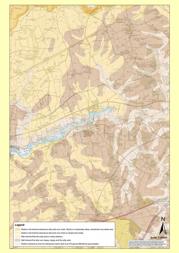
A Parish Plan for Biodiversity
                      What is Biodiversity?

‘Biodiversity’ comes from the words biological diversity and simply refers to
the variety of living things found within an area. Overton’s biodiversity ranges
from single celled micro-organisms to mammals, birds and trees. The
biodiversity of an area also refers to the range of habitats such as woodlands or
rivers where these species are found.

                                     River Test

                      Why is Overton’s Biodiversity Important?

All human life depends on healthy ecosystems and the living things they
contain.
Globally, biodiversity provides us with many of the things we need to survive –
water, oxygen, food, clothing and medicines.
Locally, Overton’s biodiversity contributes to making the village a pleasant place
to live. It enriches our lives and helps to keep us healthy – mentally as well as
physically. One of the factors which attracts people to live and work in north
Hampshire is its natural environment and wildlife.

                      Overton’s Biodiversity Plan and the Bigger Picture

In June 1992 the Earth Summit in Rio de Janeiro led to over 150 countries
signing the Convention on Biological Diversity. The main aim of the Convention
is to encourage widespread commitment to sustaining and enhancing global
biodiversity. It calls for the creation and enforcement of national strategies and
action plans to conserve, protect and enhance biological diversity.
As part of its response to the Rio Summit the UK Government published the UK
Biodiversity Action Plan in 1995 setting out our national objectives.
In 1998 the Hampshire Biodiversity Partnership set out strategic action plans for
biodiversity within the county1 followed in 2000 by specific species and habitat
action plans2.
In 2003 Basingstoke and Deane Borough Council produced “Living
Landscapes – a Landscape and Biodiversity Strategy for the Borough of
Basingstoke and Deane”. The strategy, updated in 2014, provides a framework
for the work of the council in relation to the conservation and enhancement of
landscape and biodiversity3. One of the tasks identified in the strategy was to

                                         5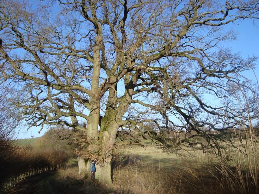
explore the development and role of parish-based conservation action plans in
helping to achieve landscape and biodiversity objectives. This key action
supports one of the guiding aims of the strategy - to encourage the participation
of local groups and people in decisions affecting the future of the borough’s
biodiversity.
A Biodiversity Action Plan for Overton was prepared for 2009-2014 to help our
community to identify the principles set out at international, national and regional
level and to put them into practice at a local level within Overton Parish. It
helped us to identify our local wildlife resources and to make suggestions on
how they might be maintained or improved. This plan for 2015-2019 builds on
what we learned from the original plan and sets out our key actions for the next
5 years.
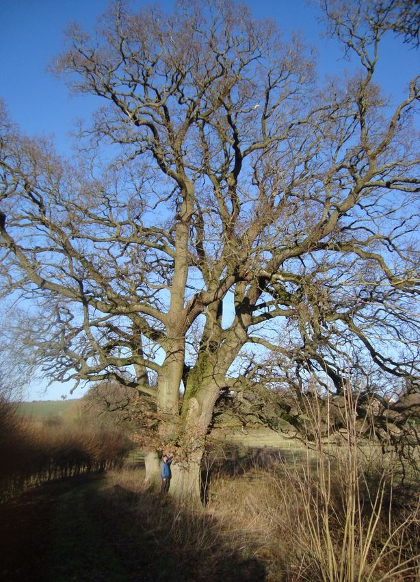
Overton's largest oak tree at Ashe, January 2015
6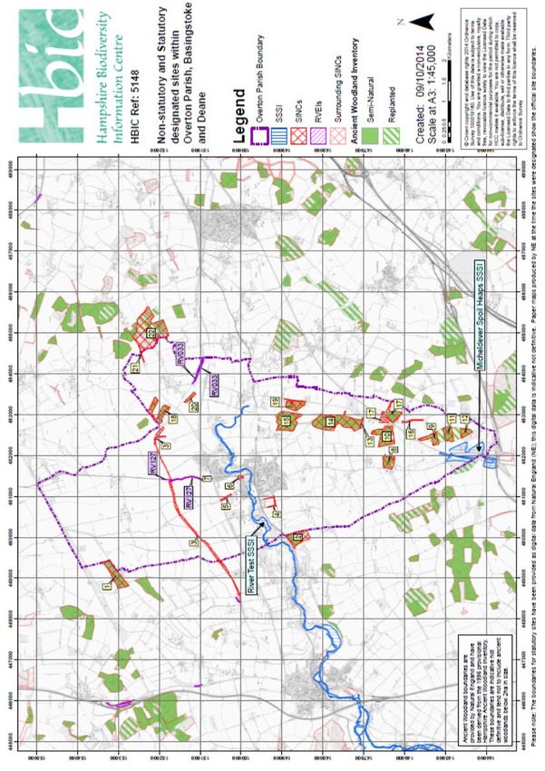
The Parish of Overton
Location
The Parish of Overton is situated in north-west Hampshire and covers an area
of approximately 35 km2 (13 square miles) on the western side of the Hampshire
Downs. It includes the upper Test valley and the source of the River Test which
rises at Ashe Manor Farm.
Overton village has approximately 4300 inhabitants and lies at the centre of the
parish in the valley of the River Test, 13 km west of Basingstoke on the B3400.

      Overton Parish within north Hampshire and the Borough of Basingstoke and Deane

                   Overton Parish Rights of Way and Transport Routes

                                          7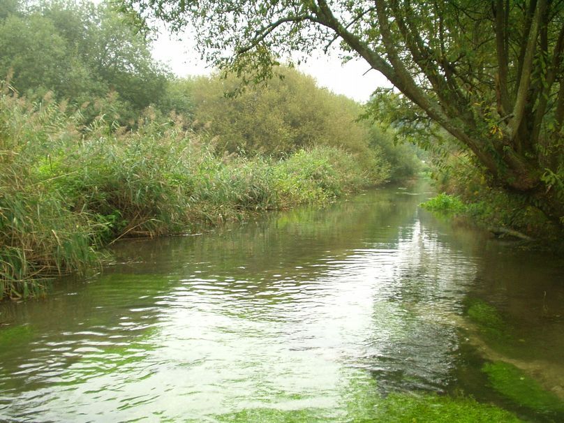
Geology and Soil
The underlying rocks of the parish form part of the Hampshire Basin, a
geological feature in which the rocks slope gently from the north to the south.
The oldest rock is Cretaceous chalk which was formed over 65 million years
                                        8
ago. This chalk is a porous, fine grained limestone which is generally highly
permeable and alkaline.
The soil types in the parish are mainly calcareous with areas of overlying
plateau drift and clay with flints. In the Test valley there are river and valley silt
and gravel deposits.
The Soil Survey of England and Wales has identified four main groups of soils
(Soil Associations) in the parish4:

 Soil Association              Characteristics

 Charity 2 Association         Well drained flinty fine silty soils in valley bottoms.
                               Calcareous fine silty soils over chalk or chalk
                               rubble on valley sides, sometimes shallow.
                               Parent materials: flinty and chalky drift over chalk.

 Frome Association             Shallow calcareous and non-calcareous loamy
                               soils over flint gravel affected by groundwater.
                               Small areas of peat. Risk of flooding.
                               Parent materials: chalky and gravelly river
                               alluvium.

 Andover 1 Association         Shallow well drained calcareous silty soils over
                               chalk on slopes and crests. Deep calcareous and
                               non-calcareous fine silty soils in valley bottoms.
                               Striped soil patterns locally.
                               Parent material: Chalk.

 Carstens Soil                 Well drained fine silty over clayey and fine silty soil,
 Association                   often very flinty.
                               Parent materials: Plateau drift and clay-with-flints.

A map showing the soil types present in the parish is given in Appendix 1.

Climate and Hydrology
Overton has a temperate climate with an average annual temperature of about
10oC and about 750 mm annual rainfall5. Just under 50% of the rainfall is lost to
evaporation and transpiration. The rest soaks into the deeper layers of the
underlying chalk which are saturated with water. This water moves through the
chalk under the influence of gravity until it emerges as springs in the river valley.
Generally, rain takes several months to filter through the underlying chalk to the
springs, so the winter rainfall swells the underground reserves and gives peak
river flows in late spring. The temperature of the water is fairly constant entering
the River Test at about 11oC regardless of the season6.
                                           9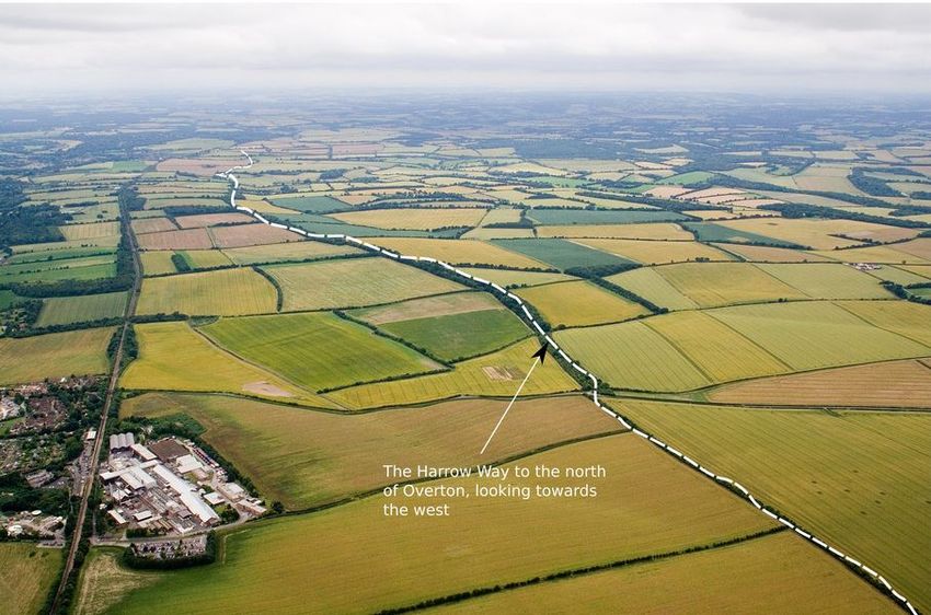
With climate change, snowfall is becoming rare and frost less common than in
the past. Predictions for the future suggest increasingly hot, dry summers with
milder, wetter winters. Extreme weather events such as storms and heavy rain
may become more common7.

Topography
The landscape of the parish owes much to the influence of the last ice age
which ended some 10,000 years ago.

        Overton village looking north over the valley of the River Test © Sue Teagle.

Although not actually covered by ice during this period (the glaciers ended
further to the north), the dry valleys in the Chalk Downs were probably formed
by stream erosion when the ground was frozen causing rainfall to run over them
rather than soaking in as it does today4.
One of the main landscape features of the parish is the valley of the River Test
which runs from east to west across the central portion of the area.
Altitudes within the parish range from 75 metres at its lowest point (where the
River Test flows out of the parish at Laverstoke) to 185 metres at Robley Belt on
the northern boundary of the parish.

                                            10
Landscape History and Archaeology
Man has influenced the landscape of the parish for thousands of years.
Evidence of human activity can be seen in the presence of:
Popham Beacons – prehistoric barrows dating to the bronze age
(2,400 – 700 BC)
Harrow Way – an ancient trackway thought to date to the iron age
(700 BC – 43 AD) or earlier
Portway - the Roman road from Silchester to Sarum which forms part of
the northern boundary of the parish
Victorian railway line - the tree-lined railway line with its impressive
embankments bisecting the northern part of the parish.
Historic landscape types identified in the parish8 include:
Assarted Woodland – early medieval to early post-medieval enclosures,
formed by the clearance of woodland and scrub to form farmland
Wavy-edged fields – fields with wavy boundaries, resulting from 17th and
18th century informal enclosure
Ladder fields – fields with long wavy-edged parallel boundaries, often
running for several kilometres over chalk uplands, resulting from 16 th and
17th century informal enclosure
Parliamentary fields – regularly shaped fields typically formed by
Parliamentary Enclosure Acts of the late 18th – 19th century.
Ladder fields looking south over Robley Belt © Sue Teagle
11Studying field patterns and their boundaries can indicate where the oldest and
most species-rich hedges are likely to be found, and gives an indication of when
and how the modern landscape has been formed.
A map showing the historic landscape types present in the parish is given in
Appendix 2.
Landscape Character Areas
Basingstoke and Deane Borough Council has identified four main “Landscape
Character Areas” within the parish, based on a study of habitats, land use and
landscape history. Each Landscape Character Area represents a tract of land
with a recognisable local identity and wildlife interest 8.
A map showing the landscape character areas present in the parish is given in
Appendix 3. The landscape character areas are described in more detail below.
12Great Litchfield Down and Willesley Warren
This open, rolling area forms a distinct character area in the northern part of the
parish with its southern boundary marked by the River Test. The area is
underlain predominantly with chalk, which has been covered in places with clay
with flint deposits. Erosion of this underlying geology has led to the formation of
a rolling, strongly undulating landform, with numerous dry valleys. Elevated relief
and lack of vegetation cover contribute to an exposed and remote character.
Landscape character within this area is comparatively uniform with coherence
and unity provided by the area’s scale and openness. Large, open arable fields,
with a weak hedgerow and woodland structure separate it from the surrounding,
more enclosed, chalkland landscapes. Occasional small areas of pasture are
distributed within the area. The area is bounded to the north by Robley Belt - a
linear plantation marking the route of the Roman road which forms the northerly
boundary of the Parish. The area north of the Salisbury to London railway line
lies within the North Wessex Downs Area of Outstanding Natural Beauty
(AONB).
Great Litchfield Down and Willesley Warren landscape character area © Sue Teagle
13Test and Bourne Valley
The River Test has cut through the underlying geology of predominantly chalk
beds giving rise to the distinct flat valley floor. The alluvial loam and valley
gravels deposited by the river results in a change in vegetation characteristics
from the surrounding chalkland.
The area consists of valley floor, slopes and built areas. The land adjacent to the
river forms a mixture of wet woodland, disused watercress beds and grazing
land, some of which is now unused and overgrown. The River Test and some
adjacent areas are designated as a Site of Special Scientific Interest (SSSI).
The valley sides have a mosaic of pasture and arable farmland interspersed
with small woodland blocks, the fields bounded by a strong hedgerow structure
and hedgerow trees. Much of the settlement within the parish is situated in this
area.
River Test at Southington © Jane MacKenzie
14South Test Down
This area is underlain with chalk layers creating a gently undulating landform
and is found to the south of the village.
Within the parish, the western part of this area is characterised by large arable
fields with low hedgerows and limited woodland cover creating a fairly open
landscape. To the east, the higher frequency of woodland and hedgerows leads
to a more enclosed landscape.
Looking north over Test Valley Golf Course showing South Test Down
landscape character area © Sue Teagle
15Oakley and Steventon Down
This area, also underlain by chalk beds, is covered by widespread deposits of
clay with flints (particularly on higher ground) which creates the characteristic
undulating landform.
The landscape comprises a patchwork of medium to large arable fields
interspersed with frequent woodland blocks. The relatively enclosed nature
created by the woodland distinguishes this area from the surrounding more
open character areas.
The area includes a high proportion of ancient seminatural woodland which has
been designated as Sites of Importance for Nature Conservation (SINCs).
The second of Overton’s two SSSIs – Micheldever Spoil Heaps is found in the
southern part of this area on the site of Victorian railway excavations now
colonised with rare plant species such as cutleaved germander (Teucrium
botrys).
Micheldever Spoil Heaps looking north © Ken MacKenzie
16Habitat Types
The Phase 1 (main) Habitat Types in the parish were mapped in 1996/97 by
Hampshire County Council and in 2006 by Basingstoke and Deane Borough
Council9. The following ten main habitats were identified as occurring locally, the
first eight of which are included in the Hampshire Biodiversity Action Plan 2.The
10 are:
1. Lowland Mixed Deciduous Woodland (areas of Wet Woodland have
also been recorded within the parish)
2. Open Standing Water / Ponds
3. Lowland Wet Grassland (which can include Floodplain Grazing Marsh
and Lowland Meadows). In addition, areas of Lowland Fen have also
been recorded in the parish)
4. Chalk Rivers
5. Wood Pasture and Parkland
6. Arable Field Margins
7. Hedgerows
8. Lowland Calcareous Grassland
9. Spoil Heaps
10. Improved Grassland
A map showing the all the habitats types recorded within the parish is given in
Appendix 5.
Lowland Mixed Deciduous Woodland
Lowland woodland forms a significant
part of the parish landscape and is a
major wildlife habitat. Although there is
no single large area of woodland in the
parish, there are many scattered
stands of mixed woodland throughout,
particularly in the south of the parish on
areas of heavier soils. Many of these
areas are classed as semi-natural
ancient woodland and have SINC
status. In addition, the parish is
covered by an extensive network of
hedgerows (around 150 km/100 miles)
providing both localised woodland habitats and a valuable green connection, i.e.
wildlife corridors between habitats.
17Open Standing Water / Ponds
Standing open water habitats are found in a few
locations adjacent to the River Test such as
settling beds associated with Overton’s paper mill.
In the past, the River Test was diverted in several
places to create watercress beds. These are no
longer used for growing watercress but remain as
important areas of open water (at Polhampton,
Flashetts and Southington) as do farm ponds and ornamental lakes.
Lowland Wet Grassland
The wildlife interest of the River Test is not
restricted to the river itself but extends to the
meadows adjacent to it. Some of these,
especially higher up in the catchment, have
been significantly improved for agriculture
whereas some of the meadows closer to the
western boundary retain more of their wildlife
interest. These areas are now largely ungrazed
and are at risk of reverting to wet woodland or conversion to unsuitable land
uses such as pony paddocks.
Several areas along the River Test are situated in lowlying areas with silty or
gravelly soils, a high water table and, sometimes, seasonal flooding (Ashe,
Polhampton, Quidhampton, Southington). These factors create a grassland
habitat distinct from the classic chalk grassland habitat.
Chalk Rivers
The source of the River Test is at Ashe on the eastern edge of the parish. It runs
westward for 4.1 km (2.5 miles) before crossing the parish boundary on the
western side.
The River Test, its associated side streams and
adjacent meadows and wet woodland, are
classed as an SSSI and widely regarded as the
Parish’s prime wildlife site. It is home to many of
the landmark species of the parish such as
kingfishers (Alcedo atthis), water voles and
18possibly otters (Lutra lutra).
However, the most recent assessments of the river within the parish by Natural
England between April 2002 and March 2006 described conditions throughout
as being “unfavourable” or “unfavourable and declining” 11.
This is due to a variety of factors including inappropriate water levels, siltation
and water pollution within the river and lack of grazing and invasion of nettles
and scrub in adjacent areas.
Himalayan Balsam (Impatiens glandulifera) has been noted in at least one
location on the banks of the river. This nonnative garden escape rapidly
colonises riverbanks and damp ground. In the autumn the plants die back
leaving the banks bare of vegetation and vulnerable to erosion.
Wood Pasture and Parkland
Areas of woodpasture and parkland were identified by
HBIC at Berrydown Court, Burley Wood and
Southington. Areas of former woodpasture also exist in
the south of the Parish adjacent to the Micheldever
Spoil Heaps SSSI.
Wood pasture and parkland are valued for their
preservation of ancient trees, often pollarded, with their
associated species, such as lichen and invertebrates.
Small areas of wood pasture and parkland exist in the
parish.
Arable Field Margins
Arable farming is the predominant form of land use
in the parish. The predominant crops grown are
wheat, barley and oilseed rape. Fields are large to
accommodate modern farm machinery and many
hedges have been removed over the last 50
years. A large part of the south of the parish is
farmed organically by Laverstoke Estate.
Sympathetic management of the field margins and headlands may encourage
farmland birds and rare arable plants such as chicory (Cichorium intybus) and
19cornflower (Centaurea cyanus).
Hedgerows
There is an extensive network of hedges within
the parish. The total length of hedgerow has
been estimated as approximately 150 km with a
density of about 4 km of hedge per kilometre of
ground area15.
Well-maintained hedges, especially when
combined with sympathetic field margin
management, are an outstanding wildlife resource. They provide shelter for a
wide range of species including many farmland birds and also make up wildlife
corridors allowing species to move safely from one area to another. Without
hedges, some species such as dormice would remain dangerously isolated in
specific locations. In addition to their importance for wildlife, hedges are also of
great landscape value and historic significance.
Overton Biodiversity Society carried out a survey of hedgerows in the parish
during 20032006. In most respects our local hedgerows were found to be very
representative of the chalky arable landscape of southern England although
they also appear to be more speciesrich than the national average 15.
Resurveying a sample of biodiverse and ‘at risk’ hedges in the parish of Overton
during 2014 revealed the physical condition to be similar to that in the original
surveys conducted during 2004, 2005 and 2006. One ‘at risk’ hedge had been
lost to housing development. There was a slight overall decrease in biodiversity
of the hedgerow species, with the ground flora also showing lower diversity.
However, no firm conclusions about decrease in biodiversity can be drawn from
the sample size of 7 hedges which were not all re-surveyed in the same month
as the original study.
Further ‘at risk’ hedges will continue to be identified by OBS. Where these relate
to housing development, surveys will be conducted to establish condition and
biodiversity to inform developers of the value of the hedgerow resource and
potential for conservation, enhancement and new planting.
20Lowland Calcareous Grassland
Only tiny areas of unimproved chalk grassland
remain in the parish, along a few road verges
(Kingsclere Road) and in Overton Church
graveyard where there is a significant glow
worm population (Lampyris noctiluca).
Spoil Heaps
These are localised areas of disturbed chalk
derived from Victorian railway cuttings found in the
southern end of the parish. The spoil heaps can
provide a habitat for a range of unusual plant
species, including the rare cutleaved germander.
Improved Grassland
Areas of grassland used for grazing
livestock are found throughout the parish.
On conventional farms these are sown
pastures containing ryegrass and are
heavily fertilised for maximum production.
On organically farmed land artificial
fertilisers are not used and the sown seed
mixtures include a wide range of herbs and
grasses.
Other land use
Although not identified as priority habitats for Hampshire the following land use
types are important locally.
Sports fields
21Overton is fortunate in having available a
wide range of recreational land. This
includes land managed by Overton
Recreation Centre, Overton Primary
School playing fields, land managed by
the Parish Council, Basingstoke and
Deane Borough Council and the privately
owned Test Valley Golf Course.
Some of this land already has
considerable wildlife potential – Town Meadow contains sections of the River
Test SSSI and has evidence of the presence of water voles while others could
be improved for wildlife without interfering with their recreational potential.
Gardens
Gardens form a major wildlife
resource within the village with
some being managed exclusively
as wildlife gardens.
Roadside Verges
There are approximately 50 km of road in
the parish - short stretches of which have
retained some of the original diversity of
chalk grassland. One section on the
B3051 Overton to Kingsclere road has
been designated as a SINC on the basis
of its floral diversity which includes
orchids.
Road side verge Kingsclere Road © Ken
MacKenzie
Little Meadow
Little Meadow is an area of about one acre adjacent to Kingsclere Road and the
22parish cemetery. The land belongs to Overton Parish Council (OPC), and has
been developed by Overton Biodiversity Society (OBS) to encourage a diversity
of wildlife and to provide a pleasant area for the people of Overton and visitors
to the parish to enjoy.
Work began on site in 2005, to introduce mainly native trees, shrubs and
wildflowers. Three hedges (one subsequently laid in January 2012) and eight
specimen trees were planted, as well as a dense area of native roses. Wild
flower seed mixtures, plug plants and container plants have been added, with
an emphasis on bee-friendly plants (not necessarily native) in the border next to
the hard standing. Structural features included the hard standing area, with
seating, human sundial and two interpretation boards, a beetle bank, stone pile
and large logs (which had rotted by 2014).
The pH of the site was found to be around 7.9.
Management aims are to maintain or increase the biodiversity of Little Meadow,
and to continue to provide an area to be enjoyed by human visitors. OBS
achieves these aims by means of working days arranged at Little Meadow as
and when required (usually about 4 days per annum ).
Information boards at Little Meadow
Nature Conservation Sites in Overton
The habitats of 40 sites within the parish have been surveyed and the records of
these surveys are kept by the Hampshire Biodiversity Information Centre
(HBIC). Some of the sites surveyed are of particular wildlife significance and
have been designated for their nature conservation importance. There are two
Sites of Special Scientific Interest (SSSIs) within the parish and 22 Sites of
Interest for Nature Conservation (SINCs).
A map showing all the designated sites within the parish is given in Appendix 4.
Sites of Special Scientific Interest
There are over 4,000 SSSIs in England, covering around 7% of the country's
land area. The designation process is managed by Natural England 10.
Notification of a site as a SSSI gives legal protection to the best sites for wildlife
23and geology in England.
There are two SSSIs within the parish – the River Test SSSI, running from east
to west through the middle of the parish and Micheldever Spoil Heaps SSSI
(also known as “the Chalkies”) in the south of the parish.
The River Test SSSI
The River Test is a classic chalk stream and is one of the most speciesrich
lowland rivers in England. The water is naturally baserich and of great clarity,
but like many lowland rivers shows evidence of nutrient enrichment.
River Test between Kingsclere Road and Station Road © Jane MacKenzie
The River Test supports a high diversity of invertebrate species and is especially
rich in aquatic molluscs.
The River Test SSSI includes areas of former water meadows, fen pasture and
rush pasture communities of botanical interest. The River Test and its adjoining
vegetation provide valuable habitats for wetland birds.
Almost the entire river is managed to maintain and facilitate fishing for trout
(brown and rainbow)11. Eels are also present in the Flashetts stretch.
Water voles (Arvicola terrestris) are common in places, but their numbers are
thought to have declined as has been noted elsewhere in Britain 12.
24Micheldever Spoil Heaps SSSI
This area, now partly managed by the Hampshire and Isle of Wight Wildlife
Trust, is an area of nineteenth century chalk spoil heaps produced during the
construction of the London to Southampton railway. The area is described as
being of “quite exceptional botanical importance” for species such as cut-leaved
germander, wall bedstraw (Galium parisiense), spring cinquefoil (Potentilla
neumanniana) and fly orchid (Ophrys insectifera)13 which have colonised the
site.
Micheldever Spoil Heaps © Ken MacKenzie
25Sites of Importance for Nature Conservation (SINCs)
SINCs are locally important wildlife sites. A SINC is a nonstatutory designation
generally administered by a local authority in partnership with conservation
organisations. The designation recognises important habitats and species on
sites that fall outside statutory site designations. Local government authorities
have schedules of SINCs within their area and include policies in their Local
Plans and Local Development Frameworks to safeguard these sites from
inappropriate development14.
SINCs within the Parish of Overton
At the time of production of the 20092014 BAP the Harrow Way and Overton
Churchyard were not recorded as surveyed by HBIC. The biodiversity value of
these areas were drawn to their attention through BAP actions and both are now
designated as SINCs.
A map showing the location of each SINC is given in Appendix 4. Comments
about each SINC and some other sites of interest, taken from habitat survey
reports held by HBIC, are presented in Appendix 5.
26Species
Overton’s habitats support a tremendous range of species, some of which are
UK & Hampshire BAP Priority Species2.
It would not be possible to review all of the species in this document, but it is
possible to select “flagship species” and to suggest ways in which they can be
protected. Flagship species meet one or more of the following criteria:
They are priority species in the Hampshire Biodiversity Action Plan
They have statutory protection
They are indicators of the health of the habitat in which they live
They are widely valued by the local community as a species of local
importance.
Water vole
(Arvicola terrestris)
The water vole is one of Britain’s
fastest declining species with
numbers having fallen by as much as
94% over the last 100 years12. The
species was once common within the
parish but is now only rarely seen.
A water vole survey carried out by
Overton Biodiversity Group in 200616
identified two areas within the parish
Water Vole © Graham Roberts
where populations have survived.
The survey also identified inappropriate river bank management and predation
by mink (Mustela vison) as major causes of their decline.
The surveys were repeated in Autumn 2014 when the estimated number of
water voles showed a sharp decline, particularly in stretches of the river where
they were previously fairly abundant (e.g. Kingsclere Road to Station Road).
This may be due to predation by mink or by inappropriate bank side
management or may be due to the survey being carried out, (for most
stretches), slightly later than in 2006, with dying back of bank side vegetation
and dead leaves making it difficult to locate signs of water vole activity, e.g. their
latrines.
27Common Dormouse
(Muscardinus avellanarius)
The common or hazel dormouse is a
small treeliving and largely nocturnal
mammal.
Dormice prefer natural woodland and
thick hedgerows so their presence is an
indication of a healthy woodland habitat.
OBS surveys conducted in 2009, 2010
and 2011 showed that dormice were
found in significant numbers in the
Overton Parish17. They were found predominantly on the Harrow Way but also in
the hedgerows around the village. Common Dormouse © Phil McLean
Kingfisher
(Alcedo atthis)
The kingfisher is a fairly rare, easily disturbed bird and
is widely seen as a symbol of the River Test.
Kingfishers require slow moving, shallow stretches of
rivers which are clean enough to support large
amounts of small fish. Kingfishers require overhanging
branches above shallow stretches of the river for their
perches. Observations have established that there is a breeding population on
the River Test.
Kingfisher © Phil McLean
28Farmland Birds
Just as the kingfisher can be seen as an
indicator of the health of aquatic
environments, farmland birds are taken as an
indicator of the environmental health of
agricultural land.
Farmland bird species include corn bunting
(Miliaria calandra), goldfinch (Carduelis
carduelis), grey partridge (Perdix perdix),
linnet (Carduelis cannabina), skylark (Alauda
arvensis), starling (Sturnus vulgaris), stock
Lapwing © Albert Roberts
dove (Columba oenas), tree sparrow (Passer
montanus), turtle dove (Streptopelia turtur), whitethroat (Sylvia communis),
lapwing (Vanellus vanellus) and yellow hammer (Emberiza citrinella). Major
reductions in their numbers have been recorded through surveys such as the
BTO Common Bird Census and Breeding Bird Survey 18 largely due to the
intensification of agriculture which has taken place over the last 50 years.
Overton is fortunate that all the local farmers are sympathetic to wildlife and a
significant part of the parish farmland is managed organically by the Laverstoke
Estate with consequent benefits for wildlife, especially farm land birds.
Black Poplar
(Populus nigra)
The black poplar is one of Britain’s rarest trees and is
associated with the wet meadow conditions found along
the valley of the River Test. Overton Biodiversity Society
has carried out a survey of notable trees in the parish and
was able to liaise with a local landowner and confirm that
one of the trees on his land is a mature black poplar.
Black Poplar © Ken MacKenzie
29Bluebell
(Hyacinthoides non-scriptus)
Southern England is one of the strongholds of the
bluebell where it is one of the indicator plants for ancient
seminatural woodland. Although fairly common they can
be threatened by illegal removal and by inappropriate
woodland management.
Spectacular bluebell woods within the parish include
Southley Copse and Burley Wood.
Bluebell © Alex Cruickshank
Glow worm
(Lampyris noctiluca)
The glow worm is a beetle about 25 mm in
length. The wingless female glows in the dark to
attract males. After mating she will lay her eggs
and then die.
Glow worms require specific conditions to
survive – snails (on which they feed) and
sensitive management of the vegetation in
which they live.
St Mary’s churchyard has a longestablished
colony of glow worms. Surveys conducted by OBs in 2009, 2010 and 2011
confirmed that, although numbers are in decline nationally, the colony of glow
Glow worm © John Horne
worms found in Overton is stable19.
30Butterflies and Moths
Most UK butterfly and moth species are declining with 24
species of butterfly and 150 species of moth now listed as
priority species on the UK Biodiversity Action Plan20.
Butterflies and moths are very sensitive to changes in their
environment and are excellent indicators of the health of their
habitats. OBS has organised talks on butterflies and moths
and has run numerous moth trapping sessions at a number of
sites in the parish. A summary of sightings between 2009 and 2014 can be
found on the OBS website.
Holly Blue butterfly
© Veronique Kerguelen
Overton Biodiversity Action Plan
Developing the new Action Plan
A summary of the outcomes of the 2009-14 BAP can be found in the Resources
Section of the OBS website22.
Based on the experience of the first Overton Parish BAP 21, the 2015-19 Action
Plan has been designed to include the following:
Identification of a realistic number of actions all of which are considered
achievable
Identification of who will be undertaking the action and where external
expertise is required
Identification of success criteria to judge how well the action has been
achieved
31The Plan below is presented in a slightly different format from the 2009-14 BAP
and covers the period from the beginning of 2015 until the end of 2019. It
outlines the broad aim, objective or continuous activities for a habitat or species,
followed by specific actions. The specific actions have timings for completion
allocated to a quarter of a particular year and with an indication of by whom the
action should be undertaken. Suggested criteria for success are also given.
For some actions, sub-groups will be set up, led by an OBS Committee member,
to plan, execute and report on the specific action.
32The Action Plan 2015-2019
Habitat or Aim, Specific Actions By When By Whom Success criteria /
species Objective or Comments
Continuous
Activities
SINCs and Raise OBS Review presence 2015 Q1 OBS Updated list of
SSSIs awareness of of SINCs 2019 Q4 Committee confirmed SINCs
sites with date of most
recent surveys
Visit to restored 2015 Q3 OBS Visit completed
part of River Test members
SSSI at
Laverstoke Park
Chalk river Promote the Arrange Winter or 2017 Q1 Invited Open meeting
importance of Spring talk speaker attended by OBS
the River Test members and
and its visitors
associated
habitats and
species
Hedgerows Monitoring Repeat 2014 2019 Q3 Hedgerow Report on website
condition of survey of at-risk sub-group detailing species
hedgerows in and species-rich and condition of
the Parish hedgerows hedges and
comparison with
previous surveys
Record Survey 2016 Q3 Hedgerow Report detailing
condition and hedgerows on or sub-group species and
diversity of adjacent to condition of
hedgerows development sites hedges for Parish
potentially at in Overton Council
risk from Neighbourhood
building work Plan
Little Meadow Maintain and Survey LM 2016 Q3 Hedgerow Report on website
(LM) enhance hedgerows sub-group detailing species
biodiversity and condition of
all LM hedges
Re-survey 2016 Q2 Expert Report on website
meadow for external detailing species
species diversity surveyor
Undertake routine Q1,Q2,Q LM sub- Planting, pruning,
maintenance 3,Q4 group weeding and
annual grass clearing, as
required
Micheldever Assist Ongoing practical Q1, Q3 Chalkies Annual
Spoil heaps Hampshire scrub clearance annual volunteers participation by
SSSI and Isle of and maintenance OBS members
Wight Wildlife and assistance
Trust with their with Cut Leaf
management Germander
of this site surveys
Gardens Raise Organise Overton 2016 Q3 OBS Visit to at least two
awareness of "Garden Safari" 2018 Q3 members Overton gardens
importance of day in each year
gardens for
biodiversity
33Habitat or Aim, Specific Actions By When By Whom Success criteria /
species Objective or Comments
Continuous
Activities
Seed initiative 2017 Q1 OBS OBS members
Committee and wider village
community
engaged in
‘growing for
wildlife’
Water vole Monitor Repeat water vole 2019 Q4 Water vole Report on website
presence of survey sub-group detailing survey
water voles and comparison
with previous
surveys
Common Monitor Repeat dormouse 2018 Q3 Dormouse Report on website
dormouse presence of survey sub-group detailing survey
dormice and comparison
with previous
surveys
Check dormouse 2015 Q3 Dormouse Confirmed
boxes sub-group number, location
and condition of
boxes and number
occupied
Black poplar Increase Propagate Black 2015 Q4 Black poplar Cuttings taken
number of BP poplar sub-group and established
trees in the from tree at
Parish Polhampton
Grow ‘other sex’ 2016 Q1 Black poplar New sapling
sapling for sub-group purchased
propagation
Glow worm Monitor Glow worm 2015 Q2 Glow worm Website report
presence of survey 2017 Q2 sub-group detailing findings
glow worms 2019 Q2 and comparison
with previous
surveys
General Promote wider Annual winter / 2015 Q1 OBS Delivery of at least
biodiversity spring meetings / 2015 Q4 Committee one event per
knowledge and talks / activities 2016 Q1 annum to
active 2016 Q4 audience of OBS
community Publicity of OBS 2017 Q1 members and
involvement; activities in Parish 2017 Q4 wider village
Liaise, News & Views 2018 Q1 community
encourage and 2018 Q4
support Tree 2019 Q1
Warden 2019 Q4
scheme
References
1. Hampshire Biodiversity Partnership 1998 Biodiversity Action Plan for Hampshire: Volume One.
Hampshire County Council
342. Hampshire Biodiversity Partnership 2000 Biodiversity Action Plan for Hampshire: Volume Two.
Hampshire County Council
3. Basingstoke and Deane Borough Council 2014 Living Landscapes a Landscape and Biodiversity
Strategy for the Borough of Basingstoke and Deane (accessed 22nd February 2015)
http://www.basingstoke.gov.uk/rte.aspx?id=733
4. Jarvis, M.G. Allen, R.H. Fordham, S. J. Hazelden, J. Moffat, A.J. and Sturdy, R.G. 1984 Bulletin 15
Soils and Their Use in southeast England. Soil Survey of England and Wales. Harpenden
5. Meteorological Office website, 1971 – 2000 Mapped Averages (accessed 23rd February 2015)
http://www.metoffice.gov.uk/climate/uk/averages/19712000/mapped.html
6. Environment Agency 2002 Leaflet Fact File 11 The River Test
7. Meteorological Office website, What is climate change (accessed 23rd February 2015)
http://www.metoffice.gov.uk/climate-guide/climate-change
8. Landscape Design Associates in association with Wessex Archaeology 2001 Basingstoke and
Deane Landscape Assessment Basingstoke and Deane Borough Council Basingstoke
9. Basingstoke and Deane Borough Council Phase 1 Habitat Survey for Overton Parish 2006 Personal
Communication
10. Natural England website Sites of Special Scientific Interest (accessed 23rd February 2015)
http://www.english-nature.org.uk/special/sssi/index.cfm
11. Natural England website SSSI Units for the River Test (accessed 23rd February 2015)
http://designatedsites.naturalengland.org.uk/SiteDetail.aspx?SiteCode=S2000170&SiteName=River
Test&countyCode=19&responsiblePerson=
12. Strachan, R & Jefferies, D.J. 1993 The Water Vole Arvicola terrestris in Britain 198990 Its
Distribution and Changing Status. The Vincent Wildlife Trust. London
13. Natural England website (accessed 23rd February 2015)
http://www.english-nature.org.uk/citation/citation_photo/1001316.pdf
14. Hampshire County Council website (accessed 23rd February 2015)
http://www3.hants.gov.uk/biodiversity/hampshire/sincs
15. Overton Biodiversity Society Hedgerow Surveys in the Parish of Overton (accessed 23rd February
2015) http://www.overtonbiodiversity.org/resources/catalogue/surveys.html
16. Overton Biodiversity Society 2007 Water Vole Survey (accessed 23rd February 2015)
http://www.overtonbiodiversity.org/resources/docs/watervolesurvey.pdf
17. Overton Dormouse survey Final report March 2011 (accessed 23rd February 2015)
http://www.overtonbiodiversity.org/resources/docs/dormousefinal.pdf
18. British Trust for Ornithology (accessed 23rd February 2015) http://www.bto.org/survey/cbc.htm
19. Glow worm survey update 2011 (accessed 23rd February 2015) http://www.overton-
biodiversity.org/resources/docs/glow-worm_report-2011.pdf
20. The UK Biodiversity Action Plan (accessed 23rd February 2015) http://jncc.defra.gov.uk/ukbap
21. Overton Parish Biodiversity Action Plan 20092014 (accessed 19th March 2015) http://www.overton-
biodiversity.org/resources/docs/overton-bap-compact.pdf
22. Report on 20092014Overton Parish Biodiversity Action Plan BAP http://www.overton
biodiversity.org/resources/catalogue/
35Abbreviations
AONB Area of Outstanding Natural Beauty
BAP Biodiversity Action Plan
BDBC Basingstoke and Deane Borough Council
BTCV British Trust for Conservation Volunteers
BTO British Trust for Ornithology
EA Environment Agency
FC Forestry Commission
FWAG Farming and Wildlife Advisory Group
HBIC Hampshire Biodiversity Information Centre
HIOWWT Hampshire and Isle of Wight Wildlife Trust
OBS Overton Biodiversity Society
OPC Overton Parish Council
ORC Overton Recreation Centre
SINC Site of Interest for Nature Conservation
SSSI Site of Special Scientific Interest
Appendices
1. Soils of Overton (map)
2. Historic Landscape Types (map)
3. Landscape Character Areas (map)
4. Designated Sites (map)
5. HBIC comments on SINCs and other sites of interest
6. Phase 1 Habitat Types (map)
36Appendix 1 – Soils of Overton
37Appendix 2 – Overton Parish Historic Landscape Types
38Appendix 3 – Overton Parish Landscape Character Areas
39Appendix
4–
Statutory
and Non-
Statutory
Designated Sites within Overton Parish
40Appendix 5 – HBIC comments on SINCs and other sites of interest
Map 1 SINC Ridgeway Copse
Ref: Name:
Survey Oct 1979 Area: 15.5 ha
Date:
Comments:
SINC is on but outside the north-west parish boundary, central grid reference
SU49005300.
No survey comments available
Map 2 SINC Rotten Hill Copse
Ref: Name:
Survey June 1991 Area: 13.4 ha
Date:
Comments:
SINC is on but outside the west parish boundary, central grid reference
SU49904870.
No survey comments available
Map 3 SINC The Harrow Way
ref: name:
Survey Apr 2010 Area: 14.6 ha
Date:
Comments:
The Harrow Way is an old drove road crossing the mid Hampshire chalk lands,
with this particular section of the Harrow Way located north of Overton,
Hampshire.
The habitats here include structurally diverse calcareous scrubs and ancient
semi-natural Ash-Hazel woodlands, some of which have been replanted with
none-native species. The site acts as a significant and important wildlife corridor
in what is essentially a landscape dominated by arable farmland.
An excellent variety of old woodland and wayside plants were recorded during
the survey, including 29 species of old woodland indicator species. The County
Notable species Birds-nest Orchid (Neottia nidus-avis) was also recorded on the
extreme western edge of the site.
41Map 4 SINC Overton Green Lanes and Sunken Tracks
Ref: Name:
Survey May 1998 Area: 0.9 ha
Date:
Comments:
A series of fine old sunken tracks and green lanes situated on a gently sloping
and northerly facing valley side site, between the western edge of Overton and
Southington. The site constitutes a series of important ecological corridors linking
the Test Valley with the open country to the south and west of Overton.
Map 5 SINC Court Drove Woodland Strip
Ref: Name:
Survey May 1998 Area: 0.9 ha
Dates:
May 2011
Comments:
Court Drove is a small ancient semi-natural Oak-Ash-Hazel-Field Maple
woodland, situated in a broad strip along the eastern side of Court Drove
between the school and the railway line, Overton.
Despite its small size the wood retains a notable number of ancient woodland
vascular plants (or indicators) including goldilocks buttercup (Ranunculus
auricomus) and Solomon's seal (Polygonatum multiflorum). Evidence would
suggest that the site supports an active population of dormice (Muscardinus
avellanarius).
Map 6 SINC St Mary's Churchyard
Ref: Name:
Survey July 2010 Area: 0.9 ha
Date:
Comments:
St. Marys Churchyard, Overton is a medium sized churchyard, dominated by
semi-improved / improved chalk grassland, situated on the northern edges of the
River Test valley, Overton, mid Hampshire. The site supports ten chalk grassland
indicator species.
Most of the churchyard is regularly mown.
42Map 7 SINC Road Verge, NS 30-B3051 Kingsclere
Ref: Name: Road, Frost Hill
Survey Aug 2003 Length: ~ 1 km
Date:
Comments:
Grassland which has become impoverished through inappropriate management
but which retain sufficient elements of relic unimproved grassland to enable
recovery.
13 species of vascular plants characteristic of unimproved chalk grassland.
Map 8 SINC Southley Copse
Ref: Name:
Survey Sept 1990 Area: 7.7 ha
Date:
Comments:
Southley Copse lies on the rolling chalklands of North Hampshire where variable
depths of drift material can give rise to unusual and surprising types of woodland.
Within intact ancient semi-natural woodland soils are often acid and impoverished
and may be seasonally wet. Centuries of extractive management have
maintained these conditions, originally under pasture woodland, later under
coppice management, and created curious monotonous stands in which ash is
rare, beech, unless introduced, usually absent, and calcicole (“chalk-loving”)
shrubs are generally restricted to banks, pits or other disturbed areas.
These woods are quite distinct from woods on thin, truly “chalky soils”, and may
be of great antiquity.
Southley Copse is a good example, and appears to be a fragment of formerly
extensive woodland.
23 ancient woodland vascular plants recorded.
Map 9 SINC Cobley Wood North
Ref: Name:
Survey April 1992 Area: 6.4 ha
Date:
43Comments:
Cobley Wood “North” is a moderately sized ancient semi-natural oak-ash wood
on a relatively flat and gently sloping site.
The wood exhibits a notable semi-natural canopy including an unusual plateau
alder stand. The wood also retains a diverse flora including some 21 ancient
woodland vascular plants.
Map 10 SINC Quidhampton Southley Copse & Pilgrims
Ref: Name: Copse
Survey May 1997 Area: 7.7 ha & 8 ha
Date:
Comments:
Quidhampton Southley Copse is a medium sized ancient semi-natural woodland,
situated on a gently sloping and flat site on the immediate side of Pilgrim's
Copse.
The wood retains a notable variety of stand types and includes the unusual old
woodland indicator plant water avens (Geum rivale).
32 ancient woodland vascular plants recorded.
Pilgrims Copse is a moderately sized, ancient semi-natural hazel and field maple
wood situated on a gently sloping hillside on the mid Hampshire chalk.
The wood is adjacent and very similar to Quidhampton Southley Copse.
28 ancient woodland vascular plants recorded.
Map 11 SINC Cobley Wood – Middle
Ref: Name:
Survey Apr 1992 Area: 7.1 ha
Date:
Comments:
Cobley Wood 'Middle' is a medium sized ancient semi-natural oak-hazel wood on
a relatively flat site.
The wood is of particular interest because of its varied semi-natural canopy and
diverse ground flora.
20 ancient woodland vascular plants recorded.
Map 12 SINC Cobley Wood – South
Ref: Name:
Survey Apr 1992 Area: 4.3 ha
44Date:
Comments:
Cobley Wood 'South' is a small ancient semi-natural copse on a gently sloping
and rather poorly drained site.
The wood retains notable variation in the semi-natural canopy, as native 'stand-
types' vary with the underlying soil and drainage characteristics of the site.
15 ancient woodland vascular plants recorded.
Map 13 SINC Field South of Bramdown Copse
Ref: Name:
Survey Aug 2000 Area: 0.2 ha
Date:
Comments:
Arable field on south facing slope, sheltered by wood to north.
Contains broad-fruited cornsalad (Valerianella rimosa), a UK BAP priority
species.
Map 14 SINC Bramdown Copse
Ref: Name:
Survey June 1985 Area: 33 ha
Date:
Comments:
A dark neglected wood.
27 ancient woodland vascular plants.
Map 15 SINC Berrydown Copse
Ref: Name:
Survey Nov 1990 Area: 20.9 ha
Date:
Comments:
Bounded to the south by “excellent old green lanes and wood hedges.
23 ancient woodland vascular plants.
Map 16 SINC Litchfield Grange Boundary Bank
Ref: Name:
45Survey Apr 1992 Area: 1.3 ha
Date:
Comments:
A strip of ancient semi-natural woodland and old hedgerow on a particularly
impressive old boundary bank...notable semi-natural canopy and retains diverse
and species rich ground flora.
Map 17 SINC Litchfield Copse
Ref: Name:
Survey Apr 1992 Area: 11.3 ha
Date:
Comments:
Litchfield Copse is a mainly ancient semi-natural copse with some notable
associated recent semi-natural and ancient/recent semi-natural stands.
The wood retains a diverse structure and a species rich flora, including some 27
species of ancient woodland indicator plants. The structure of the wood suggests
that it may be derived from wood pasture.
Evidence suggests that the copse retains a population of dormice.
Map 18 SINC Kingsdown Wood
Ref: Name:
Survey Area: 11.2 ha
Date:
Comments:
Part ancient semi-natural woodland. No survey information available.
Map 19 SINC Burley Wood & Lane
Ref: Name:
Survey Apr 2005 Area: 8 ha
Date:
Comments:
A good example of coppice-with-standards woodland and has varying ages of
coppice present. The woodland is rich in species, especially ancient woodland
indicators. In total 30 ancient woodland indicators were noted including a large
population of the county scarce herb-paris (Paris quadrififolia).
46You can also read