Decision Support Tools for River Restoration: The Implementation of the "River Habitat Survey" Methodology on the River Selho Guimarães ...
←
→
Page content transcription
If your browser does not render page correctly, please read the page content below
hydrology
Article
Decision Support Tools for River Restoration:
The Implementation of the “River Habitat Survey”
Methodology on the River Selho (Guimarães Municipality,
Northwest Portugal)
Francisco Costa *             and António Vieira

                                          Department of Geography and Communication and Society Research Centre (CECS), University of Minho,
                                          4710-057 Braga, Portugal; vieira@geografia.uminho.pt
                                          * Correspondence: costafs@geografia.uminho.pt; Tel.: +351-253510560

                                          Abstract: The river habitat survey (RHS) system is a method used to assess the physical features and
                                          quality of rivers, which was developed to assist in the conservation and recovery of riverside habitats.
                                          The RHS takes into account the need to characterize areas of intervention from a hydromorphological
                                          point of view, in order to introduce corrective measures aimed at restoring degraded sections and
                                          habitats, and increasing local biodiversity. In this paper, we present the results obtained from the
                                          application of the RHS methodology to the River Selho, in the municipality of Guimarães (Portugal).
                                          The transects that we defined were strongly influenced by anthropic actions that have modified
                                the riverside habitats, the artificialization of the river channel, and the urban occupation of the

                                          banks. Taking into account the results, we can point out the main problems that currently affect
Citation: Costa, F.; Vieira, A.           the hydromorphological quality of the transects analyzed in the River Selho, as well as identify the
Decision Support Tools for River          originating factors: the excessive silting of the watercourse; morphometric changes, with an emphasis
Restoration: The Implementation of        on the narrowing and modification of the channel and the banks; as well as the massive destruction
the “River Habitat Survey”
                                          of the riparian zone. This study shows that the application of the RHS methodology is a useful tool
Methodology on the River Selho
                                          for the management of degraded riverside areas.
(Guimarães Municipality, Northwest
Portugal). Hydrology 2021, 8, 69.
                                          Keywords: restoration; management; aquatic resources; tool
https://doi.org/
10.3390/hydrology8020069

Academic Editor: Amartya K. Saha
                                          1. Introduction
Received: 30 January 2021                      The ecological status of water bodies is an expression of the quality of the structure
Accepted: 15 April 2021                   and functioning of water systems, classified according to the composition and abundance of
Published: 21 April 2021                  biological elements, hydromorphological conditions, and the physico-chemical conditions
                                          supporting the biological elements [1,2]. The importance of hydromorphological conditions
Publisher’s Note: MDPI stays neutral      for river ecosystem quality, related to channel morphology and the presence of natural
with regard to jurisdictional claims in   riverine habitat features and riverbank vegetation, has long been taken into consideration.
published maps and institutional affil-   In December 2000, the Directive 2000/60/EC–Water Framework Directive (WFD) for river
iations.                                  ecosystem assessment considered this factor in its implementation [2].
                                               The observation of river dynamics has led several researchers to classify such envi-
                                          ronments according to their different features. This type of approach has a strong geomor-
                                          phological appeal, seeking to evaluate and compare the different basins/drainages [3,4].
Copyright: © 2021 by the authors.         From an ecological point of view, several studies proposed the classification of river en-
Licensee MDPI, Basel, Switzerland.        vironments, applied not only to environmental analysis but also to biomonitoring [5–11].
This article is an open access article    The literature also presents combinations of grouped information related to the physical
distributed under the terms and           environment, biological aspects, and chemical analyses [8,12,13], as in the case of the En-
conditions of the Creative Commons        vironmental Protection Agency [14] and Directive 2000/60/EC [1]. The WFD introduced
Attribution (CC BY) license (https://
                                          an obligatory hydromorphological quality element to assess the ecological status of Euro-
creativecommons.org/licenses/by/
                                          pean rivers [15], underlining its importance in the classification of river systems [16,17].
4.0/).

Hydrology 2021, 8, 69. https://doi.org/10.3390/hydrology8020069                                        https://www.mdpi.com/journal/hydrology
Hydrology 2021, 8, 69                                                                                            2 of 20

                        Raven et al. [17] conducted a comparative study in order to provide the European Com-
                        mittee for Standardisation (CEN) with technical guidance for establishing a standard for
                        assessing the hydromorphological features of rivers [1,16,18–23]. Several methods for
                        characterizing the physical structure of rivers and assessing habitat quality have been
                        independently developed across Europe since the early 1990s [15,17,24–34]. Much of these
                        methods are not suitable for some types of rivers, particularly those that are very long or
                        have highly seasonal flows [17], and require a certain scientific knowledge, materials, and
                        time for their calculation [34], making it difficult to perform a quick assessment from a
                        technical point of view [35].
                              Moreover, under the influence of the overall purpose and specific content of the
                        WFD [15,17], the British Environment Agency developed the RHS project [36]. The main ob-
                        jective of the project was to establish an accessible methodology from a technical–scientific
                        point of view for denoting habitat features and evaluating the importance of wildlife in
                        a river ecosystem [37,38]. These specially targeted “benchmark” surveys, implemented
                        in Britain and Ireland, were extended to mainland Europe, including rivers in Finland,
                        Norway, Slovenia, Bavaria, the Tyrolean Alps, the Cévennes in south-eastern France,
                        Poland, northern Spain, and southern Portugal [30,39–44]. Medeiros [45] reported that this
                        methodology has been consistently tested in several countries [39–41,43,46–49], proving
                        advantageous in different lines of research, from habitat assessment for the establishment
                        of various species [50], to erosion risk assessment [51]. The RHS method is also commonly
                        used for river ecological valorization in Switzerland, Germany, Czech Republic, Denmark,
                        and Latvia. In a modified form [39,45] it was used in Italy, Greece, and Poland, mainly
                        in scientific research [21,47], and also in Spain for hydrographic basin management pur-
                        poses [48]. The comparison of RHS and other habitat assessment methods has also been
                        part of this European wide initiative [17]. The RHS assessment parameters can also be used
                        directly for river protection and restoration [52–54]. The RHS has been used for many types
                        of studies for WFD compliant monitoring of water bodies [55–60]: the STAR project [45];
                        national research projects [56,61–63]; and environmental impact assessment studies [15].
                        The RHS made an important contribution to determining the degree of modification of
                        river hydromorphology [39] and in the development of the CEN standard “water quality:
                        guidance standard for assessing the hydromorphological features of rivers (EN 14,614 of
                        2004)” [38]. As highlighted by Newson et al. [54], RHS is not a directly geomorphological
                        assessment, but rather a diagnosis of ecological status.
                              The first attempts to apply RHS in Portugal were made at the beginning of the 1990s,
                        in association with research projects on limnology and aquatic ecology [64,65], and using
                        global indexes to assess human disturbance and establish links between the river biota
                        and hydromorphological modifications [15]. Since no standard national protocol existed
                        before WFD implementation, the Portuguese Environment Agency (PEA) adopted the RHS
                        as an official hydromorphological quality assessment tool in 2011 [15,39,43,44,55]. The
                        PEA has developed partnerships to adapt the RHS as a method for the morphological
                        analysis of rivers, taking advantage of the fact that in some national universities there is
                        already research experience related to the application of this method [39,45,66]. RHS was
                        first used on the island of Madeira by Hughes [61], followed by Cortes et al. [56,62] on
                        the Portuguese mainland, with the purpose of identifying priority areas for restoration
                        measures along disturbed rivers [15]. The RHS was also applied in two river segments
                        in the North of Portugal, subject to different anthropogenic pressures [34]. Currently, the
                        main practical uses of RHS fall within the scope of river basin management plans [52], the
                        ecological characterization of requalification projects [67], and the environmental impact of
                        river works [34].
                              The RHS is a versatile field method used to “characterise and assess, in broad simple
                        terms, the physical character of freshwater streams and rivers” [39], and as a result of
                        accurately defined parameters [21,68]. The assessment of habitat quality and extent of
                        channel modification can be derived from RHS data [39], reflected in indexes used for
                        setting physical quality objectives for rivers [69]. The RHS database allows sites of a similar
Hydrology 2021, 8, 69                                                                                              3 of 20

                        nature to be grouped together for comparative purposes [39]. Channel slope, distance
                        from source, height of source, and site altitude are used to cluster RHS sample sites for
                        the so-called “context analysis”, based on principal components analysis (PCA) plots [70].
                        The RHS is used in the hydromorphological evaluation of homogenous river sections (not
                        surface water bodies) and is compatible with European standards [21,71]. The application
                        of the RHS takes into account the need to characterize the intervention areas from an
                        environmental point of view, to assess the impact of the disturbances along the sections
                        under study, and in order to introduce corrective measures aimed at restoring degraded
                        habitats and increasing local biodiversity [34].
                              With this article we intended to test this quality index of riverside habitats and its ease
                        of application, thinking about its usefulness as a tool for assessing the conservation status of
                        a river course, from hydromorphology, to the structure of riverside and aquatic vegetation.
                        It is concerned with evaluating the applicability of the RHS method in water courses
                        and its utility for daily decision-making processes in activities covered by the licensing
                        regime for the use of water resources. Consequently, we considered the implementation of
                        this methodology in our study area of great value, and our proposal was to characterize
                        transects selected in the River Selho from a hydromorphological point of view and to
                        evaluate their vulnerability and state of conservation.

                        2. Materials and Methods
                             The River Selho basin is a sub-basin of the River Ave, which is located between
                        parallels 41◦ 230 33.2” N and 41◦ 310 18.600 N, and meridians 8◦ 120 48.600 W and 8◦ 220 41.700 W,
                        with a predominant NE–SW direction. The area of this basin is 68 km2 , and it is located
                        almost entirely within the Guimarães municipality (Figure 1).

                        Figure 1. Location of River Selho in the Guimarães Municipality and selected transects for
                        RHS application.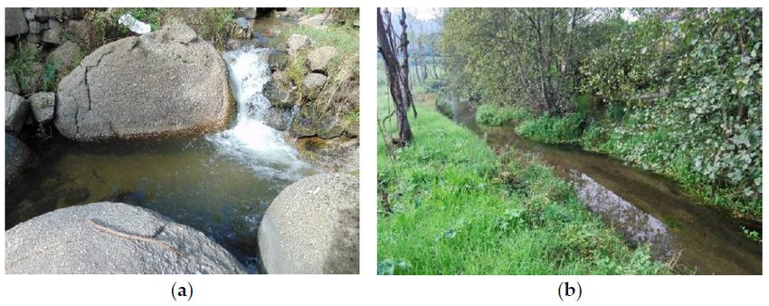
Hydrology 2021, 8, 69                                                                                           4 of 20

                             With the river’s source at 580 m altitude, the watershed totals an extension of 236 km.
                        The River Selho covers a distance of almost 21 km, resulting in a medium-low average
                        slope of only 2.4% in its main course [72]. The area is thus strongly prone to flooding, since
                        river flow is hindered by the low average longitudinal slope. In most of the middle and
                        lower course of the River Selho there is a slow discharge that encourages silting of the
                        channel, obstructing the river system and making the flood flows more severe [72].
                             There have been very few river restoration projects in the Guimarães Council [73],
                        and even these have not been continued or monitored. Our proposal is thus intended as
                        an intervention methodology for the River Selho in the Guimarães Municipality, and in
                        identified locations with major hydrological, environmental, and landscape problems.
                             The RHS evaluates the physical structure of watercourses based on a standard 500 m
                        sampling transect [45,74], which requires extensive fieldwork to identify visually prede-
                        fined features and to draft survey forms. The RHS offers a semi-objective method developed
                        and tested in scenarios different from those that normally characterize Portuguese river
                        ecosystems [34]. Therefore, adaptations of the RHS form and methodology were required
                        in order to fulfil some WFD requirements not covered by the original methodology. The
                        RHS form is divided into 18 sections [14] and includes the characteristics of fluvial channel,
                        land use, and adjacent river corridor attributes, such as geology, slope, or distance from the
                        source [37]. A field survey obtains the data pertaining to both in-stream and bank features,
                        collected in 10 spot-checks, with a 50 m distance between each (Figure 2).

                        Figure 2. Diagram showing elements for spot-checks. Source: [37,74].

                             Spot-check observations, complemented with surveillance between them, provide
                        an image of river values as a natural ecosystem. The insights into hydromorphological
                        state elements are input: predominant valley form, information about riffles, pools and
                        point bars, artificial features, the material of banks, their modifications and features, land
                        use, bank profile shape, channel dimensions, and others are presented. Apart from the
                        presence of plants on banks, bars, and those within the channel, such elements describing
                        the vegetation structure can be distinguished as: the type of vegetation in the adjacent area
                        (scrubs, shrubs, orchard, woodland etc.), vegetation structure uniformity level, bryophytes
                        and lichens presence, free-floating, floating leaved plants, amphibious, submerged plant
                        appearance, and algae presence [37].
                             There are some elements in the form that are not completely applicable to the river
                        Selho, which is consistent with other studies performed in mainland Portugal [39,45,66].
                        Thus, we opted for a Portuguese version prepared by the INAG in 2010, adapting some
                        aspects related to: Section Q, a section open to the identification of relevant regional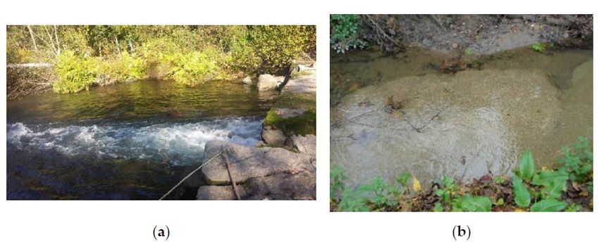
Hydrology 2021, 8, 69                                                                                           5 of 20

                        problems; Section O, where the local species are registered; and Section F, related to uses
                        and structure of the vegetation of the margins in a 10 m strip to count the bed-limit line, as
                        stipulated in Portuguese Law No. 54/2005, of 15 November.
                              One of the determining concerns in the application of the RHS in the river Selho was
                        the definition of the sampling program, regarding the representativeness of the sample
                        vis-à-vis the population [70]. In the present work, 5 transepts were carried out on the main
                        course of the river Selho, having accessibility as a fundamental aspect, guaranteeing not
                        only safe conditions, but also that the field work could be effective. Sampling also involves,
                        according to the described methodology, an assessment of risks for the observer. For this,
                        there is an additional form, in which some questions about the location are prior evaluated,
                        so that the observer can indicate the degree of associated risk; classified as low, moderate,
                        and high. In the case of the present study, sampling was limited to places with a high
                        probability of success, that is, with the possibility of being able to evaluate sections with
                        a continuous extension of 500 m, avoiding areas whose characteristics could prevent this
                        objective from being reached. The selection of the sampling sites includes the completion
                        of complete transepts and in safe conditions [45].
                              The selection of transects is based on the collection of systematic samples that are rep-
                        resentative of watercourses with problems, in terms of flow and physical degradation [45].
                        The sampled sections were located in urbanized and industrialized areas, areas with al-
                        terations essentially associated with agricultural, livestock, and forestry exploration, as
                        well as areas occupied by weed vegetation (Figure 3). In general, the main landscape units
                        existing in the region that had already been defined in previous projects, and visited in field
                        work for recognition [72,73,75], were covered. The samples were therefore representative
                        of all water courses in the basin.
                              The RHS system has four distinct components: (i) a field survey method; (ii) a com-
                        puter database for entering results from survey sites; (iii) a set of methods for assessing the
                        habitat quality; and (iv) a system for describing the level of man-made channel modifica-
                        tion [76]. RHS data recorded on the field sheets have to be manually introduced into the
                        freely downloadable Rapid 2.1 software developed by the Centre for Ecology and Hydrol-
                        ogy, UK [77]. Implemented using Microsoft Access for Windows, Rapid 2.1 can be used
                        to store RHS data and calculate HMS and HQA indexes [55]. Hydromorphological river
                        quality is expressed via the habitat quality assessment (HQA) and habitat modification
                        score (HMS) indexes, two quantitative parameters calculated from RHS survey information.
                        The HQA provides information about the level of the naturalness of the section. HMS
                        describes the modification degree of the chosen reach, i.e., if there is a measure of the
                        deviation in a section from its natural, intact state.
                              Based on previous surveys and contacts established with authorities from the Guimarães
                        municipality, 5 transects (Figures 1 and 3) were selected, validated from criteria defined by
                        the security protocol, so that the fieldwork could be effective [75].
                              The survey and fieldwork were implemented by walking, from May 2018 to September
                        2018. The data collection was made with the support of a checklist [74], and part of the
                        RHS methodology, with some adaptations implemented to the specific study area. Various
                        tools were used in this survey (measuring tape, camera, GPS, among others).
                              The method used to collect data was based on the RHS form and was designed to be ro-
                        bust, associated with a good database and geographical information system, and intended
                        to support management measures, public information, and future interventions [70].
Hydrology 2021, 8, 69                                                                                                 6 of 20

                        Figure 3. Transects 001, 002, 003, 004, and 005. Source: orthophotos provided by the Municipality of
                        Guimarães (2012).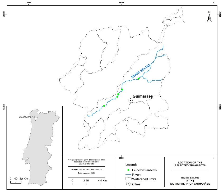
Hydrology 2021, 8, 69                                                                                          7 of 20

                        3. Results and Discussion
                        3.1. Results from the RHS Implementation
                             The RHS form is divided into 18 sections, regarding which we present a brief analysis
                        for each of the 5 transects of the River Selho.
                        -    Section B: Predominant valley form.
                             Despite some local particularities, there is a certain homogeneity in the valley forms
                        in the basins studied, given their small size and similar geological origin. V-shaped valleys
                        prevail, with gentle, not very pronounced slopes, which are sometimes asymmetric.
                        -    Section C: Number of riffles, pools, and point bars.
                             The natural features we identified appeared, essentially, in the form of riffles (17 oc-
                        currences) and point bars (39 of 41 corresponding to vegetated point bars), reflecting the
                        orographic characteristics associated with the basin (Figure 4a,b), such as its short length
                        and high average slopes. They stand out for their impacts on habitats, flow regulation
                        and, consequently, risk management. The presence of point bars indicates the capacity for
                        sediment transport, the greater or lesser dynamic of which is reflected in the rooting or not
                        of vegetation.

                        Figure 4. Aspects associated with Section C: (a) Pools; (b) Unvegetated point bar.

                        -    Section D: Artificial features (Table 1).

                        Table 1. Representativeness of observations in Section D.

                                   ARTIFICIAL FEATURES                                    Transects (Total)
                                       Major weirs/sluices                                         3
                                   Intermediate weirs/sluices                                     3
                                       Minor weirs/sluices                                         3
                                          Major bridges                                            2
                                      Intermediate bridges                                        4
                                         Minor bridges                                             5
                                      Major outfalls/intakes                                      1
                                  Intermediate outfalls/intakes                                    3
                                     Minor outfalls/intakes                                        4
                                           Major fords                                             1
                                       Intermediate fords                                         1
                                           Minor fords                                             1
                                 Major deflectors/groynes/croys                                    6
                             Intermediate deflectors/groynes/croys                                10
                                Minor deflectors/groynes/croys                                     3
Hydrology 2021, 8, 69                                                                                         8 of 20

                             The number of artificial features reflects a significant degree of anthropic modifica-
                        tions, essentially associated with water use or improving mobility and security conditions.
                        Among the wide range of structures provided in the RHS form, we found most types
                        represented by structures of different sizes (Figure 5a,b). We highlight the transversal
                        structures, particularly the importance of weirs for agricultural activity and hydroelectric
                        production. The description of the types of structure is related not only to their size, but
                        also to their possible impact on the structure and functionality of the watercourse.

                        Figure 5. Aspects associated with Section D: (a) Minor bridges; (b) Major bridges.

                        -    Section E: Physical attributes (1-m wide transect) (Tables 2 and 3).

                        Table 2. Representativeness of observations in Section E for the banks.

                                            BANKS                                         Transects (Total)
                                                                   Bank material
                                            Bedrock                                                1
                                            Boulder                                               35
                                         Cobble/gravel                                            12
                                             Earth                                                14
                                        Cement/concrete                                           11
                                        Stone/brick wall                                          21
                                         Tipped debris                                             1
                                           Not visible                                             5
                                                                Bank modifications
                                           Not Visible                                             7
                                           No change                                              22
                                           Resectioned                                            11
                                           Reinforced                                             66
                                            Poached                                                5
                                                            Marginal and bank features
                                            None                                                  4
                                          Stable cliff                                            64
                                     Unvegetated point bar                                        2
                                      Vegetated point bar                                         5
                                      Vegetated side bar                                          29
                                        Natural berm                                               1
                                          Not visible                                             6
Hydrology 2021, 8, 69 9 of 20
Table 3. Representativeness of observations in Section E for the channel.
CHANNEL Transects (Total)
Channel substrate
Bedrock 1
Boulder 3
Cobble 3
Sand 27
Gravel/pebble 15
Not visible 3
Flow-type
Free fall/chute 2
Chaotic flow 5
Upwelling 1
Smooth (Laminar flow) 40
Channel modification
None 27
Culverted 1
Resectioned 4
Reinforced 20
Dam/weir/sluice 4
Ford 7
Not visible 1
Channel features
Exposed bedrock 14
Exposed boulders 12
Vegetated rock 11
Unvegetated mid-channel bar 11
Vegetated mid-channel bar 34
Mature island
Not visible 3
Unobservable 3
Trash (urban debris) 25
Other features
Presence of sub-channels 16
As far as the bank material is concerned, natural and traditional processes prevail,
and boulders and stone walls abound. It should also be noted that cement/concrete
elements appear frequently. The composition of the bank material was confirmed, with
modifications mostly associated to interventions to reinforce and resect stretches of the
River Selho. There was also many vegetated side bars, which show the high capacity of the
river’s hydrodynamics.
Regarding the channels (Table 3), we noted significant granulometric variability that
ranged from transects filled with boulders, to sand (Figure 6a,b), predominant materials in
the River Selho. The low turbulence of the flow is also worth mentioning.
Figure 6. Aspects associated with Section E: (a) Boulders; (b) Sand.
- Sections F and H: Banktop land-use and vegetation structure (Table 4).Hydrology 2021, 8, 69 10 of 20
Table 4. Representativeness of observations in Section F.
Land-Use Transects (Total)
Broadleaf/mixed woodland (semi-natural) 3
Broadleaf/mixed plantation 3
Scrub and shrubs 7
Orchard 5
Wetland (peat, mangrove, swamp) 1
Moorland/heath 2
Artificial reservoirs/pools 2
Improved/semi-improved grassland 2
Tall herb/rank vegetation 6
Rock, scree or sand dunes 2
Urban or suburban development 10
Tilled land 10
Irrigated land 2
Parkland or gardens 2
Not visible 2
Roads and paths 7
Building ruins 2
Low density urban area 5
Medium to high density urban area 6
Most of the land use provided for in the survey form can be observed on the River
Selho, within 50 m of the banktop. This situation reflects the region’s typical land use,
where housing and industry are diffuse in the countryside, which is dominated by cropland
and some woodlands. As for vegetation structure, the four types defined in the survey form
(bare, uniform, simple, and complex) were recorded in almost all the transects identified
(Figure 7).
Figure 7. Aspects associated with Section F.
We highlighted the prevalence of more complex structures along the River Selho, both
on the banks and on the slopes of its watercourses.
- Section G: Channel vegetation types (Table 5).
Table 5. Representativeness of observations in Section G.
Channel Vegetation Types Transects (Total)
Liverworts/mosses/lichens 29
Emergent broad-leaved herbs 3
Emergent reeds/sedges/rushes/grasses/horsetails 16
Floating-leaved (rooted) 11
Free-floating 1
Amphibious 13
Submerged broad-leaved 2
Submerged linear-leaved 10
Submerged fine-leaved 12Hydrology 2021, 8, 69 11 of 20
The type of vegetation found in a watercourses may reflect not only the surrounding
habitats, but also the flow dynamics. As a result of rooted vegetation, conditions are created
for the establishment of specific communities. Many of the flora species observed in the
channels were similar to the usual vegetation in areas along the banks, or even in areas
further away from the watercourses. The type of flora reflected the high degree of habitat
changes, although there were still some areas with a lower degree of change, bearing
vegetation structures in a better state of conservation.
- Section I: Bank profiles (Table 6).
Table 6. Representativeness of observations in Section I.
Bank Profiles Transects (Total)
Natural/unmodified
Gentle 6
Artificial/modified
Reinforced (total) 10
Top only bank reinforcement 2
Toe only bank reinforcement 2
Artificial–set-back embankment 1
The bank profiles of the transects analyzed revealed an imbalance, when consid-
ering natural and artificial/modified typology. This situation reflected signs of erosion
processes, which, in the case of modified profiles, had been mitigated, or had generated
new risks, caused by design errors in these artificial structures. Bank reinforcements do
indeed highlight these different risk situations, associated with possible erosion and mass
movement processes.
- Section J: Extent of trees and associated features (Table 7).
Table 7. Representativeness of observations in Section J.
Trees and Associated Features Transects (Total)
Distribution
None 1
Isolated/scattered 3
Regularly spaced, single 1
Occasional clumps 3
Semi-continuous 1
Associated features
Shading of channel 5
Overhanging boughs 2
Exposed bankside roots 1
Underwater tree roots 1
Fallen trees 1
Large woody debris 3
The presence of trees and their dispersion may stabilize the banks, or cause obstruc-
tions due to their fall. Considering the distribution of trees and associated features in
biogeographical terms, this can be very useful in the planning of management actions,
particularly to identify segments where clearance is needed.
- Section L: Channel dimensions (Table 8).Hydrology 2021, 8, 69 12 of 20
Table 8. Summary of observations in Section L.
Transects Number of
Channel Dimensions Average (m) Maximum (m) Minimum (m)
Measurements Measurements
Bank
Banktop height (both banks) 5 5 2.22 3.5 1.25
Bankfull height (both banks) 1 1 6.4
Channel
Bankfull width 5 5 9.5 17.2 3.4
Water width 5 5 10.98 17.2 6
Water depth 5 5 0.41 17.2 0.31
Trashline height
Wetted channel width 5 5 7.55 17.2 3.5
In this section, we present an overview of the measurements made in the transects
(Figure 8a,b).
Figure 8. Channel surveying, associated with Section L: (a) width measurements; (b) height measurement.
- Section M: Features of special interest.
This section covers a range of structures that can be observed in watercourses that pro-
vide additional information, particularly regarding their dynamics and potential habitats.
We highlighted the low number of features of special interest and their poor representa-
tiveness, apart from the large boulders, typical of the dominant geological substrate in this
region, porphyroid granite rock.
- Section P: Overall characteristics.
The features recorded in this section directly reflect permanent or recent activities that
may decisively influence aspects of river management, such as runoff, water quality, and
habitat integrity. We highlighted problematic and urgent situations such as accumulated
debris, polluting discharges, and sewage. On this last point, we highlighted the works
and structures associated with the Ave Valley Integrated Pollution Management System,
which sometimes interferes with the stability of the banks and the regular water flow.Hydrology 2021, 8, 69 13 of 20
Some activities observed were also considered, such as deforestation, associated with forest
exploitation, or fisheries management, associated with fish restocking.
3.2. The Habitat Quality Assessment (HQA) and Human Modification Score (HMS) Indices
HQA provides a broad indication of the overall habitat diversity provided by natural
features in the channel and river corridor, whereas HMS is an indication of artificial
modifications to river channel morphology [39,43]. HQA scoring considers: (i) flow
types, (ii) channel substrates, (iii) channel features, (iv) bank features, (v) bank vegetation
structure, (vi) instream channel vegetation, (viii) land use within 50 m, (ix) trees and
associated features, and (x) special features. Consequently, its sum is calculated. This can
be used to quantify improvement or degradation of habitat quality. This scoring system
basically shows the features of the physical structure of the site (including channel and
river corridor). Points are scored for the presence of features such as point, side and mid-
channel bars, eroding cliffs, large woody debris, waterfalls, backwaters, and floodplain
wetlands. Additional points reflect the variety of channel substratum, flow-types, in-
channel vegetation, and also the extent of banktop trees and the extent of near-natural land
use adjacent to the river.
HQA is a score of habitat quality and the diversity of features, such as substrate and
flow types, as well as other in-channel features, such as deposition bars. The diversity
and character of features at any site is influenced by natural variations and also the extent
of human intervention, both in the channel and on adjacent land. Comparisons between
different HQA’s should only occur for rivers of a similar character, or for sections of the
same river [34]. The RHS database allows HQA scores to be compared using sites with
similar physical characteristics (e.g., bedslope, distance from source) and geology. This
index is normally expressed in absolute values, which increase with the increase in the
quality of the habitat. High values of HQA demonstrate high diversity and a significant
number of natural elements in a channel and within the surrounding area [37]. The higher
the HQA, the more diverse the river habitat and the potential for supporting biodiversity.
The second index concerns the HMS and allows measuring the extent to which the
natural characteristics of the sampling section have been anthropically modified. The HMS
provides an estimate of the degree of modification and presence of artificial features.
This includes such parameters as the quantity and size of particular types of wa-
ter structures (dams, crossings, culverts, groynes, bridges), anthropogenic bank profile
transformations (reinforcing, resectioning, embanking, bank devastation by cattle, riparian
plants mowing), and bottom modifications (reinforcing, resectioning, dredging, artificial
bottom material, carving water plants).
HMS values increase with the increasing degree of modification, and a value of zero
indicates that there are no significant anthropogenic changes. The cumulative points pro-
vide the HMS. Habitat modification class (HMC) has been developed, which allocates
a site into one of five modification classes, based on the total score (1 = semi-natural;
5 = severely modified). In contrast to HQA, low HMS values indicate the lack of modifi-
cation or insignificant hydromorphological transformations of rivers, whereas high HMS
indicates extensive changes. A cumulative HMS score can be used to summarize the
significance and the extent of structural alteration of the channel.
Although some subjective assumptions are considered (such as the value/weight of
the score for each characteristic), it is an objective measure, allowing a consistent com-
parison between locations, regardless of the type of river. This is a more robust index for
the simulation/prediction of the consequences of certain interventions on the beds and
margins of watercourses, in terms of their structural alteration.
The HQA and HMS numerical indices are inversely proportional; two ecologically
similar river sections could be characterized by different anthropogenic influences [37],
which do not necessarily lead to a drop in the hydromorphological quality of a river. This
is the case for human efforts in river restoration that lead to increasing the naturalness of a
habitat [21].Hydrology 2021, 8, 69 14 of 20
The two quality indices, HQA and HMS, were applied to the sampled transects in the
River Selho using Rapid 2.1 software (Table 9).
Table 9. Results obtained in the HQA and HMS indices for the transects analyzed.
HSM HQA
001 5 (1595) 65
002 5 (1750) 56
003 5 (3050) 65
004 5 (2625) 60
005 5 (5010) 66
Note: values in ( ) correspond to the absolute values obtained in the HSM calculation.
The HQA scores obtained varied between 56 and 66, while the HMS scores were all 5.
The high HMS scores reflect the intense influence of anthropogenic action on these riverside
habitats, through the building of artificial channel structures and the urban occupation of
both banks. This situation is severe throughout the River Selho. The wide range of features
was influenced by natural variation and by the extent of human intervention, both in the
channel and in adjacent areas. In relation to the HQA assessment, we obtained results
that reflect the progressive degradation of biodiversity and the disappearance of existing
vegetation along the river channel, a result of the high level of modification.
Considering the results obtained, we can point out the main problems that currently
affect the hydromorphological quality in the River Selho (Table 10), as well as the factors
originating them.
Table 10. Summary table of the problems detected in the River Selho.
Transects Erosion Silting Morphometric Changes Degradation of Riparian Zone Trash Flood
001 (×) (+) (+) (+) (×) (×)
002 (−) (×) (×) (+) (×) (×)
003 (×) (+) (+) (+) (×) (×)
004 (×) (+) (+) (+) (×) (×)
005 (−) (+) (+) (+) (×) (×)
(−), Not found; (×), observed; (+), significant.
Excessive silting of the watercourses, morphometric changes, with an emphasis on
the narrowing and resectioning of the channel and banks, and massive destruction of the
riparian zone were the most significant processes identified in the transects analyzed [31].
3.3. Limitations and Advantages of the Application of the RHS
The RHS system was structured and developed for the situation in the United King-
dom and, therefore, it is shaped according to the river characteristics, occupation, and land
uses that exist there. On the other hand, the RHS encompasses a set of technical terms that
do not always have a direct correspondence in Portuguese, making it difficult to identify
characteristics and collect field data [34].
There are well-known difficulties in applying the RHS to Mediterranean rivers, and
adaptations have been developed for southern Europe [39,78]. However, the rivers of the
northwest of Portugal, where the River Selho is located, were not considered.
Some of the difficulties encountered in using the RHS methodology for the River Selho
were related to the natural hydromorphological processes associated with Mediterranean
rivers in northwest of Portugal, namely river flow variation, which can in some cases be
influenced by processes resulting from human intervention. In these cases high annual
and interannual flow variability increases the difficulty of recognizing and accurately
recording the macrophyte growth, substrate type and composition, flow types, erosion, and
depositional features directly affected [15]. Especially in the case of rivers in the northwest
of Portugal, their torrentiality and hydraulic seasonality limits to the summer the optimumHydrology 2021, 8, 69 15 of 20
period for the collection of field data [34]. Thus, it became necessary to adapt the RHS
form to allow greater sensitivity to anthropogenic changes, in addition to calibrating the
values that emanated from them, to correctly assess the various stages of environmental
degradation [34].
These adaptations comprised necessary minor adjustments to lotic conditions and
the re-definition of descriptions covering land use categories, special features, and notable
nuisance plant species [15]. Non-native invasive species are widely established along the
River Selho, particularly in those areas which have been modified or have a high degree of
disturbance. Thus, adaptations regarding riparian vegetation were also integrated into this
version of the RHS form [15,79,80].
We summarize some of the difficulties and uncertainties identified with the application
of the RHS to the River Selho:
- Difficulty in classifying and identifying natural berms.
- Many streams and rivers are affected by minor fords and malls, and old dams and weirs.
This affects both upstream (ponded) and downstream flow and substrate patterns.
- Subchannels are relatively common features, where seasonal flow has extreme variations.
- Small stretches of homogeneous smooth or non-perceptible flow make it difficult to
separate artificial and naturally ponded flow.
- Due to the variation in flow regime, it is very difficult to define the banktop. Some
sites have multiple side bars, recorded at several spot checks along the survey reach.
- Different types of land use occur along River Selho that are not included in the original
RHS form.
- The annual flow variability directly affects features such as macrophyte development
and complexity, substrate characteristics, and the accumulation of organic debris. In
particular, the dominant flow types and flow diversity are affected.
To avoid misinterpretation the version of RHS we used included the count of side
bars in the survey form. The banktop definition was determined using several clues (e.g.,
the “annual flood” trashline). The land use categories should reflect local/regional land
management and included, wherever possible, additional categories within standard RHS
types. Due to the flow seasonal variability, the timing of the survey is critical [37]. We
followed the period considered appropriate for southern Europe, coincident with the
beginning of the summer [39,43]. Given the small size of the Selho river channel, it was
also possible to carry out fieldwork to validate some of the RHS parameters in the winter,
namely, type of flows, aquatic vegetation, and forms of sedimentation.
The most significant features of the method are its precision, reproducibility of scores,
and the facility for carrying out a statistical analysis of the obtained results. Elements of
the environment are evaluated objectively, and the method is quite cheap and easy to carry
out [21]. This technique presents a remarkable flexibility [34], being suitable for small and
medium-sized Mediterranean rivers when surveyed in the spring [39], and having been
used in several regions of mainland Portugal and Madeira island [39,45,61,62]. In terms
of feasibility, the entire RHS sampling process is more suitable for rivers with a narrow
and shallow channel, as is the case for the River Selho, as this allows better visibility of the
opposite bank and the characteristics of the bed.
The results obtained show the need to develop the application of the RHS in other
rivers in the northwest of Portugal, considering that:
- it is rapid, simple, and based on a standardized approach (strict field protocol) [22,23]
and quality control procedures (training and accreditation, quality assurance routines);
- it was one of the methods used to develop the CEN Standard on Hydromorphology;
- it allows the production of comprehensive results for managers, scientists, and com-
munity groups [39].
4. Conclusions
The RHS was developed in response to a need for information on the physical structure
and quality of habitats in rivers. Its application considers the need to characterize the interven-Hydrology 2021, 8, 69 16 of 20
tion areas from a hydromorphological point of view, to assess the impact of the disturbances
along the sections under study, with the objective of introducing corrective measures aimed
at restoring degraded sections and habitats, and increasing local biodiversity.
Using the RHS methodology, it was possible to identify the main problems currently
affecting the hydromorphological quality of the transects analyzed in the River Selho, as
well as to point out the factors behind them: excessive silting of the watercourses, and
morphometric changes, with an emphasis on narrowing and resectioning of the channel
and banks, as well as the massive destruction of the riparian zone.
Based on field studies in the River Selho and restoration works implemented we
can conclude that the RHS method can be used, not only for the evaluation of present
hydromorphological status, but also for forecasting the impact of morphological and
habitat changes, namely the ones promoted by river restoration works. Furthermore,
the implementation of RHS produces a significant quantity of data, extremely useful for
comparative analysis of various ecological design solutions, and in considering different
stages of ecological restoration processes [21].
The method used to collect data was based on the RHS form and was designed to
be robust and associated with a good database and geographical information system,
as well as intended to support management measures, public information, and future
interventions [70].
The RHS was tested, within the scope of this work, from the perspective of considering
its future use as a decision support tool in the management of water resources at a local level.
At a regional scale, the RHS will have wide applications, regarding its integration with the
WFD, and considering the identification of pressures on water bodies. In this context, the
characterization of water courses, establishment of reference conditions, grouping of water
courses in the respective typologies, and establishment and application of management
measures are obligations of the administration that will clearly benefit from the adoption
of this methodology [45].
The application of RHS to the entire national territory, within the scope of the imple-
mentation of the WFD, will allow overcoming the local character with which this model
was applied by us, and identifying the actual state of physical degradation of the river
corridors [34].
The attribution of numeric values to each hydromorphological element, assayed in
RHS research, allows the identification of those which should be considered in describing
the river restoration plans [68]. Thus, the RHS provides basic information on the current
situation of river habitats, enabling the formulation of very detailed environmental di-
agnoses. At the same time, it identifies the areas and factors that contribute to a certain
degree of habitat quality, and the areas subject to changes in their natural state, as a result
of pressures that are also characterized. This set of interconnected potentialities make
the RHS system a very effective tool for identifying suitable areas for the environmental
restoration of river ecosystems and the promotion of good channel management, and thus
helping to plan and monitor the rehabilitation of riverside habitats [34].
An inventory is also needed to develop a robust HQA scoring protocol for Mediter-
ranean rivers [39]. HQA constitutes a scoring system based on characteristics relevant to
biodiversity. Regardless of its application, this index should only be used to compare rivers
of the same type, so its calibration is suggested based on the classification obtained in the
places considered to be of the highest quality; thereby establishing a reference for each type
of river. A national scoring protocol should be developed in Portugal to reflect the river
and riparian features that contribute to natural habitat diversity and quality [81].
The single most important technical requirement is the development of a standard
protocol for recording and assessing, in simple terms, the extent and character of riparian
habitat that can be used as an addendum, and cross-referenced to the core RHS survey [80].
Like other countries that have little baseline information on ecological and hydromorpho-
logical features required by the WFD, a cost-effective sampling strategy is needed [39].Hydrology 2021, 8, 69 17 of 20
The application of the RHS methodology has undoubtedly proved to be a very re-liable
tool for the management of degraded riparian areas. Following the hydromorphological as-
sessment and definition of the intervention measures, the next step is to develop integrated
intervention projects, adapted to the scale of the problems identified.
Author Contributions: The both authors jointly developed all the tasks of the conceptualization,
methodology, formal analysis and investigation, data curation, original draft preparation, and writing,
review and editing. Both authors have read and agreed to the published version of the manuscript.
Funding: This research was funded by the Municipality of Guimarães. The English translation and
revision were funded by national funds through FCT-Foundation for Science and Technology, I.P.,
under the Multiannual Financing of the Communication and Society Research Center 2020–2023
basic financing, with reference UIDB/00736/2020.
Institutional Review Board Statement: Not applicable.
Informed Consent Statement: Not applicable.
Data Availability Statement: The data presented in this study are available on request from the
corresponding author.
Conflicts of Interest: The authors declare no conflict of interest.
References
1. EC. Diretiva 2000/60/CE do Parlamento Europeu e do Conselho, de 23 de Outubro de 2000, Que Estabelece um Quadro Comunitário de Ação
no Domínio da Política da Água; EC: Brussels, Belgium, 2000.
2. Pio, S.; Henriques, A.G. O Estado Ecológico Como Critério para a Gestão Sustentável das Águas de Superfície. Atas do 5◦ Congresso da
Água “A Água e o Desenvolvimento Sustentável: Desafios Para o Novo Século”; Associação Portuguesa de Recursos Hídricos: Lisboa,
Portugal, 2000; pp. 1–15.
3. Jung, K.; Niemann, J.D.; Huang, X. Under what conditions do parallel river networks occur? Geomorphology 2011, 132, 260–271.
[CrossRef]
4. Rosgen, D.L. A classification of natural rivers. Catena 1994, 22, 169–199. [CrossRef]
5. Abdi, M.; Afsharzadeh, S. An analysis of vegetation and species diversity patterns in sand dune and gravel desert ecosystem. Bot.
Sci. 2016, 94, 499. [CrossRef]
6. Van Der Maarel, E.; Espejel, I.; Moreno-Casasola, P. Two-step vegetation analysis based on very large data sets. Vegetation 1987,
68, 139–143. [CrossRef]
7. Manhas, R.K.; Gautam, M.K.; Kumari, D. Two Way Indicator Species Analysis (TWINSPAN) of the Herbaceous Vegetation in an
Inland Wetland Ecosystem of Doon Valley Himalaya, India. J. Wetl. Ecol. 2009, 3, 23–31. [CrossRef]
8. Szoszkiewicz, K.; Buffagni, A.; Davy-Bowker, J.; Lesny, J.; Chojnicki, B.H.; Zbierska, J.; Staniszewski, R.; Zgola, T. Occurrence and
variability of River Habitat Survey features across Europe and the consequences for data collection and evaluation. Hydrobiology
2006, 566, 267–280. [CrossRef]
9. Aroviita, J.; Hämäläinen, H. The impact of water-level regulation on littoral macroinvertebrate assemblages in boreal lakes.
Hydrobiology 2008, 613, 45–56. [CrossRef]
10. Braioni, M.G. Faunistic research in a fluvial ecosystem study: The case of the River Adige. Boll. Zoöl. 1994, 61, 415–424. [CrossRef]
11. Braioni, M.G.; De Franceschi, P.; Braioni, A.; Campeol, G.; Caloi, S.; Grandis, N.; Pontiroli, A.; Ravanello, P. New environmental
indices for assessing bank quality in the restoration and the sustainable management of a river. Ecohydrol. Hydrobiol. 2001, 1,
133–154.
12. Wyrick, J.W.; Klingeman, P.C. Proposed fluvial island classification scheme and its use for river restoration. River Res. Appl. 2010,
27, 814–825. [CrossRef]
13. Thomson, J.R.; Taylor, M.P.; Brierley, G.J. Are River Styles ecologically meaningful? A test of the ecological significance of a
geomorphic river characterization scheme. Aquatic. Conserv. Mar. Freshw. Ecosyst. 2004, 14, 25–48. [CrossRef]
14. Environment Agency. River Habitat Survey—Field Guidance Manual; Environment Agency: Bristol, UK, 1997.
15. Ferreira, J.; Pádua, J.; Hughes, S.J.; Cortes, R.M.; Varandas, S.; Holmes, N.; Raven, P. Adapting and adopting River Habitat Survey:
Problems and solutions for fluvial hydromorphological assessment in Portugal. Limnetica 2001, 30, 263–272. [CrossRef]
16. Boon, P.J.; Holmes, N.T.; Raven, P.J. Developing standard approaches for recording and assessing river hydromorphology: The
role of the European Committee for Standardization (CEN). Aquat. Conserv. Mar. Freshw. Ecosyst. 2010, 20, S55–S61. [CrossRef]
17. Raven, P.; Holmes, N.; Charrier, P.; Dawson, F.; Naura, M.; Boon, P. Towards a harmonized approach for hydromorphological
assessment of rivers in Europe: A qualitative comparison of three survey methods. Aquat. Conserv. Mar. Freshw. Ecosyst. 2002, 12,
405–424. [CrossRef]
18. Armitage, P.D.; Pardo, I. Impact assessment of regulation at the reach level using macroinvertebrate information from mesohabi-
tats. Regul. Rivers Res. Manag. 1995, 10, 147–158. [CrossRef]Hydrology 2021, 8, 69 18 of 20
19. Kemp, J.L.; Harper, D.M.; Crosa, G.A. The habitat-scale ecohydraulics of rivers. Ecol. Eng. 2000, 16, 17–29. [CrossRef]
20. Popek, Z.; Wasilewicz, M. Comparison of morphological characteristics of natural and regulated river reaches based on example
of the Wkra River. Prz. Naukowy Inż. Kształt. Śr. 2004, 30, 128–137. (In Polish)
21. Kiraga, M.; Popek, Z. Using the River Habitat Survey method in forecasting effects of river restoration. Ann. Wars. Univ. Life Sci.
SGGW. Land Reclam. 2014, 46, 125–138. [CrossRef]
22. IPQ. EN 14614. Water Quality-Guidance Standard for Assessing the Hydromorphological Features of Rivers; Instituto Português da
Qualidade (IPQ): Lisboa, Potual, 2004; 24p.
23. IPQ. EN 15843. Water Quality-Guidance Standard on Determining the Degree of Modification of River Hydromorphology; Instituto
Português da Qualidade (IPQ): Lisboa, Potual, 2010; 28p.
24. Resh, V.H.; Mcelravy, E.P. Contemporary Quantitative Approaches to Biomonitoring Using Benthic Macroinvertebrates. In Fresh-
water Biomonitoring and Benthic Macroinvertebrates; Rosenberg, D.M., Resh, V.H., Eds.; Chapman and Hall: New York, NY, USA;
London, UK, 1993; pp. 159–194.
25. Ghetti, P.F.; Ravera, O. European Perspective on Biological Monitoring. In Biological Monitoring of Aquatic Systems; Loeb, S.L.S.,
Ed.; Lewis Publishers: London, UK, 1994; pp. 31–46.
26. Karr, J.R. Defining and measuring river health. Freshw. Biol. 1999, 41, 221–234. [CrossRef]
27. Meyer, J.L. Stream Health: Incorporating the Human Dimension to Advance Stream Ecology. J. N. Am. Benthol. Soc. 1997, 16,
439–447. [CrossRef]
28. Wright, J.; Furse, M.; Moss, D. River classification using invertebrates: RIVPACS applications. Aquat. Conserv. Mar. Freshw.
Ecosyst. 1998, 8, 617–631. [CrossRef]
29. Raven, P.J.; Fox, P.; Everard, M.; Holmes, N.T.H.; Dawson, F.H. River Habitat Survey: A New System for Classifying Rivers
According to Their Habitat Quality. In Freshwater Quality: Defining the Indefinable? Boon, P.J., Howell, D.L., Eds.; The Stationery
Office: Edinburgh, Scotland, 1997; pp. 215–234.
30. Raven, P.J.; Boon, P.J.; Dawson, F.H.; Ferguson, A.J.D. Towards an integrated approach to classifying and evaluat-ing rivers in the
UK. Aquat. Conserv. Mar. Freshw. Ecosyst. 1998, 8, 383–393. [CrossRef]
31. Raven, P.; Holmes, N.; Dawson, F.; Everard, M. Quality assessment using River Habitat Survey data. Aquat. Conserv. Mar. Freshw.
Ecosyst. 1998, 8, 477–499. [CrossRef]
32. Turak, E.; Flack, L.K.; Norris, R.H.; Simpson, J.; Waddell, N. Assessment of river condition at a large spatial scale using predictive
models. Freshw. Biol. 1999, 41, 283–298. [CrossRef]
33. Boulton, A.J. An overview of river health assessment: Philosophies, practice, problems and prognosis. Freshw. Biol. 1999, 41,
469–479. [CrossRef]
34. Oliveira, D.; Fernandes, A.; Rapazot, J.; Teixeira, L.; Brioso, R.; Valente, C.; Teixeira, F.; Medeiros, M.; Cortes, R. A Utilização
do “River Habitat Survey” na Gestão Ambiental de Ecossistemas Fluviais. Potencialidades e Limitações. In Proceedings of the
Associação Portuguesa de Recursos Hídricos—7th Congresso da Água, Lisbon, Portugal, 8–12 March 2004.
35. Verdonschot, P.F. Integrated ecological assessment methods as a basis for sustainable catchment management. Hydrobiology 2000,
422–423, 389–412. [CrossRef]
36. Teodosiu, C.; Barjoveanu, G.; Teleman, D. Sustainable water resources management 1. River basin management and the EC Water
Framework Directive. Environ. Eng. Manag. J. 2003, 2, 377–394. [CrossRef]
37. Kiraga, M. The Diversification of River Habitat Survey Output During the Four Seasons: Case Studies of Three Lowland Rivers
in Poland. J. Ecol. Eng. 2020, 21, 116–126. [CrossRef]
38. CEN. Water Quality: Guidance Standard for Assessing the Hydromorphological Features of Rivers; EN 14614: 2004; European Committee
for Standardisation: Brussels, Belgium, 2004.
39. Raven, P.J.; Holmes, N.; Pádua, J.; Ferreira, J.; Hughes, S.; Baker, L.; Taylor, L.; Seager, K. River Habitat Survey in Southern Portugal;
Relatório do Environment Agency e Instituto da Água, I.P: Lisboa, Portugal, 2009; 30p.
40. Raven, P.J.; Holmes, N.; Dawson, H.; Withrington, D. River Habitat Survey in Slovenia; Results from 2005; Environment Agency:
Bristol, UK, 2005; 28p.
41. Raven, P.J.; Holmes, N.; Dawson, H. River Habitat Survey in the Ardèche and Cévennes Areas of South-Eastern France; Results from
2007; Environment Agency: Bristol, UK, 2007; 28p.
42. Raven, P.J.; Holmes, N.T.H.; Dawson, F.H.; Fox, P.J.A.; Everard, M.; Fozzard, I.R.; Rouen, K.J. River Habitat Quality—The Physical
Character of Rivers and Streams in the UK and Isle of Man; River Habitat Survey Report Number 2; Environment Agency: Bristol, UK;
Scottish Environment Protection Agency: Stirling, Scotland; Environment and Heritage Service: Belfast, North Ireland, 1998; 84p.
43. Raven, P.J.; Holmes, N.; Scarlett, P.; Furse, M.; Ortiz, J.B. River Habitat Survey in the Picos de Europa; Northern Spain, Results from
2008; Environment Agency, IH Cantabria, Centre for Ecology & Hydrology: Lancaster, UK, 2009; 36p.
44. Raven, P.J.; Holmes, N.T.; Vaughan, I.P.; Dawson, F.H.; Scarlett, P. Benchmarking habitat quality: Observations using River
Habitat Survey on near-natural streams and rivers in northern and western Europe. Aquat. Conserv. Mar. Freshw. Ecosyst. 2010, 20,
S13–S30. [CrossRef]
45. Medeiros, C.F.R. A Utilização do River Habitat Survey Como Ferramenta de Apoio à Decisão na Gestão dos Recursos Hídricos
nos Açores. Master’s Thesis, Universidade dos Açores, Ponta Delgada, Portugal, 2011; 352p.
46. Furse, M.T.; Hering, D.; Brabec, K.; Buffagni, A.; Sandin, L.; Verdonschot, P.F.M. The ecological status of European rivers:
Evaluation and intercalibration of assessment methods. Hydrobiology 2006, 566, 1–2. [CrossRef]Hydrology 2021, 8, 69 19 of 20
47. Jusik, S.; Szoszkiewicz, K. Possibilities of use of the River Habitat Survey to the needs of Water Framework Directive in Poland.
Acta Sci. Pol. Form. Circ. 2010, 9, 23–34.
48. CHE. Aplicación del índice RHS (River Habitat Survey) a la Cuenca del Ebro; Mastergeo, S.L., Zaragoza, S.L., Eds.; Confederación
Hidrográfica del Ebro, Medio Ambiente, Territorio y Geografía: Zaragoza, Spain, 2011.
49. Raven, P.J.; Holmes, N.; Scarlett, P.; Szoszkiewicz, K.; Lawniczak, A.; Dawson, H. River Habitat and Macrophyte Surveys in Poland;
Results from 2003 and 2007; Environment Agency: Bristol, UK, 2008; 30p.
50. Caswell, P.A.; Aprahamian, M.W. Use of River Habitat Survey to Determine the Spawning Habitat Characteristics of Twaite shad
(Alosa Fallax Fallax). Bull. Fr. Pêche Piscic. 2001, 362, 919–929. [CrossRef]
51. Newson, M.D. Geomorphological concepts and tools for sustainable river ecosystem management. Aquat. Conserv. Mar. Freshw.
Ecosyst. 2002, 12, 365–379. [CrossRef]
52. Raven, P.J.; Holmes, N.T.H.; Naura, M.; Dawson, F.H. Using river habitat survey for environmental assessment and catchment
planning in the U.K. Hydrobiology 2000, 422–423, 359–367. [CrossRef]
53. Dawson, F.H.; Raven, P.J.; Gravelle, M.J. Distribution of the morphological groups of aquatic plants for rivers in the U.K.
Hydrobiology 1999, 415, 123–130. [CrossRef]
54. Newson, M.D.; Clark, M.J.; Sear, D.A.; Brookes, A. The geomorphological basis for classifying rivers. Aquat. Cons. Mar. Freshwat.
Econ. 1998, 8, 415–430. [CrossRef]
55. Cunha, A.; Gonçalves, P.; Barreira, J.; Trigo, A.; Hughes, S.J. Mobile RHS: A Mobile Application to Support the “River Habitat
Survey” Methodology. Procedia Comput. Sci. 2015, 64, 87–94. [CrossRef]
56. Cortes, R.M.V.; Varandas, S.; Hughes, S.J.; Ferreira, M.T. Combining Habitat and Biological Characterization: Ecological Validation
of the River Habitat Survey. Limnetica 2008, 27, 39–56. [CrossRef]
57. Hughes, S.J.; Ferreira, T.; Cortes, R.V. Hierarchical spatial patterns and drivers of change in benthic macroinvertebrate communities
in an intermitente Mediterranean river. Aquat. Conserv. Mar. Freshw. Ecosyst. 2008, 18, 742–760. [CrossRef]
58. Cortes, R.; Hughes, S.; Varandas, S.; Magalhães, M.; Ferreira, M. Habitat variation at different scales and biotic linkages in lotic
systems: Consequences for monitorization. Aquat. Ecol. 2009, 43, 1107–1120. [CrossRef]
59. Cortes, R.M.V.; Hughes, S.J.; Pereira, V.R.; Varandas, S.G.P. Tools for bioindicator assessment in rivers: The importance of spatial
scale, land use patterns and biotic integration. Ecol. Indic. 2013, 34, 460–477. [CrossRef]
60. Coelho, D.; Hughes, S.J.; Varandas, S.; Cortes, R.M.V. Conservation benefits of riparian buffers in urban areas: The case of the Rio
Corgo (north Portugal). Fundam. Appl. Limnol. 2014, 185, 55–70. [CrossRef]
61. Hughes, S. A Study of Freshwater Macroinvertebrate Fauna of Madeira and Their Application in a Regional Ecological Assessment
System. Ph.D. Thesis, Kings College, London, UK, 2003.
62. Cortes, R.M.V.; Oliveira, D.G.; Lourenço, J.M.; Fernandes, L.F.S. Different Approaches for the Use of Bioengineering Techniques
in the Rehabilitation of Lotic and Lentic Systems: Two Case Studies in North Portugal. In Fifth International Symposium of
Ecohydraulics; Jálon, D.G., Martinez, P.V., Eds.; IAHR: Madrid, Spain, 2004; pp. 658–662.
63. Cortes, R.M.V.; Oliveira, S.V.; Magalhães, M.; Pinto, P. Um índice de avaliacão do estado de conservação do habitat fluvial
aplicado no âmbito da Directiva Quadro da Água. In Proceedings of the 9◦ Congresso da Água—Água: Desafios de Hoje,
Exigências de Amanhã, Cascais, Portugal, 2–4 April 2008.
64. Cortes, R.M.V. Biotipologia de Ecossistemas Lóticos do Nordeste de Portugal. Ph.D. Thesis, UTAD, Vila Real, Portugal, 1989; 257p.
65. Ferreira, M.T. Estrutura e Dinâmica Das Comunidades de Macrófitos Lóticos da Bacia Hidrográfica do Rio Sorraia. Interferências
dos Ecossistemas Agrários Envolventes. Ph.D. Thesis, Instituto Superior de Agronomia, Lisboa, Portugal, 1992; 402p.
66. Ferreira, J.; Pádua, J. Hidromorfologia Fluvial no Âmbito da Directiva-Quadro da Água (DQA). In Relatório de Actividades
Relacionadas com o River Habitat Survey (RHS); Instituto da Água, I.P: Lisboa, Portugal, 2009; 12p.
67. Kemp, J.L.; Harper, D.M. River Deben Alleviation of Low Flows Scheme: Proposals for Channel Habitat Physical Rehabilitation in
Association with Flow Augmentation; Environment Agency: London, UK, 1997.
68. Szoszkiewicz, K.; Zgoła, T.; Jusik, S.; Hryc-Jusik, B.; Dawson, F.; Raven, P. Hydromorfologiczna Ocean Wód Płynacych. ˛
In Podr˛ecznik do Badań Terenowych Według Metody River Habitat Survey w Warunkach Polski, 3rd ed.; Centre for Ecology and
Hydrology, Poznań: Warrington, UK, 2008. (In Polish)
69. Walker, J.; Diamond, M.; Naura, M. The development of physical quality objectives for rivers in England and Wales. Aquat.
Conserv. Mar. Freshw. Ecosyst. 2002, 12, 381–390. [CrossRef]
70. Jeffers, J.N.R. The statistical basis of sampling strategies for rivers: Na example using River Habitat Survey. Aquat. Conserv. Mar.
Freshw. Ecosyst. 1998, 8, 447–454. [CrossRef]
71. Ilnicki, P.; Gołdyn, R.; Murat-Błażejewska, S.; Soszka, H.; Górecki, K.; Grzybowski, M.; Krzemińska, A.; Lewandowski, P.; Skocki,
K.; Sojka, M.; et al. The Elaboration of Monitoring and Classification Methods of Hydromorphological Quality Assesment of River and Lake
Water Bodies in Accordance with Water Framework Directive. Stage II; GEPOL: Poznań, Poland, 2009. (In Polish)
72. Vieira, A.; Costa, F.; Bento-Gonçalves, A. Caraterização e Análise Geográfica dos Cursos de Água do Município de Guimarães; Centro de
Estudos em Geografia e Ordenamento do Território e Câmara Municipal de Guimarães: Guimarães, Portugal, 2016; 74p.
73. Costa, F.S. PRIOS-Projeto de Reabilitação do Rio Selho: Um Exemplo de Intervenção na Zona Urbana de Guimarães. Actas do II Congresso
Internacional de Engenharia Civil e Território “Água, Cultura e Sociedade; Colegio de Inge-nieros de Caminos, Canales y Puertos de
Galicia: Vigo, Spain, 2013; pp. 495–506.You can also read