Historical cartographic and topo-bathymetric database on the French Rhône River (17th-20th century)
←
→
Page content transcription
If your browser does not render page correctly, please read the page content below
Earth Syst. Sci. Data, 13, 1939–1955, 2021
https://doi.org/10.5194/essd-13-1939-2021
© Author(s) 2021. This work is distributed under
the Creative Commons Attribution 4.0 License.

         Historical cartographic and topo-bathymetric database
             on the French Rhône River (17th–20th century)
               Fanny Arnaud1 , Lalandy Sehen Chanu1 , Jules Grillot1 , Jérémie Riquier2 , Hervé Piégay1 ,
                         Dad Roux-Michollet3 , Georges Carrel4 , and Jean-Michel Olivier5
           1 Universitéde Lyon, CNRS UMR 5600 EVS, École Normale Supérieure de Lyon, Lyon 69342, France
                    2 Universitéde Lyon, CNRS UMR 5600 EVS, Université Jean Monnet Saint-Etienne,
                                                 Saint-Etienne 42023, France
                                       3 Syndicat du Haut-Rhône, Yenne 73170, France
                                   4 INRAE, RECOVER, Aix-en-Provence 13182, France
               5 Université de Lyon, Université Claude Bernard Lyon 1, CNRS, ENTPE, UMR5023 LEHNA,

                                             Villeurbanne CEDEX 69622, France
                                Correspondence: Fanny Arnaud (fanny.arnaud@ens-lyon.fr)

                               Received: 9 September 2020 – Discussion started: 27 November 2020
                           Revised: 23 March 2021 – Accepted: 24 March 2021 – Published: 10 May 2021

       Abstract. Space and time analyses of channel changes, especially within large rivers subject to high levels of
       human impact, are critical to address multiple questions about rivers in the Anthropocene era. The reconstruction
       of long-term (> 150 year) evolutionary trajectories permits an understanding of how natural and anthropogenic
       factors impact hydromorphological and ecological processes in rivers, helps with the design of sustainable man-
       agement and restoration options, and may also help in the assessment of future changes. However, the recon-
       struction of channel changes can be challenging: historical data are often scattered across many archives, and
       the quantity and accuracy of information generally decreases as one goes back in time. This data article provides
       a historical database of 350 cartographic and topo-bathymetric resources on the French Rhône River (530 km
       in length) compiled from the 17th to mid-20th century, with a temporal focus prior to extensive river training
       (1860s). The data were collected in 14 national, regional, and departmental archive services. A table describes
       the properties of each archived data item and its associated iconographic files. Some of the historical maps are
       available in a georeferenced format. A GIS layer enables one-click identification of all archive data available for
       a given reach of the French Rhône River. This database provides substantial new material for deeper analyses of
       channel changes over a longer time period and at a finer time step compared with previously available data. The
       database has several potential applications in geomorphology, retrospective hydraulic modelling, historical ecol-
       ogy, and river restoration, as well as permitting comparisons with other multi-impacted rivers worldwide. The
       dataset is available at https://doi.org/10.1594/PANGAEA.922437 (Arnaud et al., 2020a). Iconographic extracts
       of the 350 archived items are available at http://photo.driihm.fr/index.php/category/52 (last access: 2 May 2021).

1   Introduction                                                   The analysis of long-term (> 150 year) channel changes
                                                                   provides a holistic understanding of the trajectory of flu-
Characterization of the evolutionary trajectories of the           vial hydrosystems and their drivers, which helps in defining
world’s rivers and floodplains is crucial for assessment of        process-based restoration objectives, rather than determining
space–time changes in biogeomorphic processes, the quan-           static reference states (Dufour and Piégay, 2009; Eschbach et
tification of anthropogenic impacts, and the planning of sus-      al., 2018). It is necessary to extend the timescale of past tra-
tainable management based on conservation and restoration          jectories to characterize possible shifts in baseline conditions
options (Grabowski et al., 2014; Mould and Fryirs, 2018).

Published by Copernicus Publications.
1940                                                F. Arnaud et al.: Database on the French Rhône River (17th–20th century)

related to climate variability and different degrees of human        Bravard, 2010; Provansal et al., 2014; Parrot, 2015; Dépret
pressures to help in the assessment of future river changes in       et al., 2017; Räpple, 2018; Thorel et al., 2018; Tena et al.,
the Anthropocene (Pont et al., 2015; Słowik, 2015; Piégay et         2020). Therefore, the post-1860 planform adjustments are
al., 2020).                                                          fairly well understood and are combined with vertical adjust-
   The reconstruction of river trajectories requires substan-        ments measured on reaches where topo-bathymetric informa-
tial historical datasets. Series of maps, aerial images, topo-       tion has been available since the late 19th century. However,
graphic, and bathymetric surveys are generally selected at           little is known about the morphodynamics of the Rhône in
regular time steps, if available, or before and after major          the early 19th century and times before this.
events (floods, river engineering phases) to assess changes in           This paper presents a historical database of 350 carto-
the river hydromorphological conditions. This set of archival        graphic and topo-bathymetric resources covering the French
materials is used to extract channel features such as active         Rhône River, collected from 14 national, regional, and de-
channel width, bar-island areas (Hohensinner et al., 2004,           partmental archive services. The timescale extends from the
2021; Michalková et al., 2011; Scorpio et al., 2015; Lestel et       17th to the mid-20th century, with a pre-1860 focus for carto-
al., 2018), bed degradation and floodplain aggradation rates         graphic data and a pre-1900 focus for topo-bathymetric data.
(Steiger et al., 2001; Downs et al., 2013; Arnaud et al., 2015),     The aim of this paper is to provide substantial new material
riparian vegetation patterns (Cadol et al., 2011; Belletti et al.,   to extend and detail historical trajectories of the Rhône River
2013; Kui et al., 2017; Safran et al., 2017), and landscape unit     for a wide range of research applications including histori-
characteristics (Dufour et al., 2015; Solins et al., 2018; Pié-      cal hydrology and historical biogeomorphology, within flood
gay et al., 2020). Following Roux et al. (1989) and Habersack        management and river rehabilitation contexts. The compiled
and Piégay (2008), comparative analyses of river changes,            database will enable further comparisons with other large
notably in Europe, have become a critical issue for address-         braided and/or anabranching multi-impacted rivers world-
ing a series of questions of interest to geographers, historians,    wide.
engineers, ecologists, geologists, and geochemists. For ex-
ample, historical maps can help to better contextualize sed-
iment core samples and geophysical surveys when investi-             2   Study area
gating floodplain evolution (Salvador and Berger, 2014) and
delta evolution during the Holocene (Vella et al., 2005). His-       The Rhône is an 812 km long river connecting the French–
torical cartographic and topo-bathymetric datasets are also          Swiss Alps with the Mediterranean Sea. Originating at the
of interest to hydrologists analysing flood frequency based          Furka Glacier, the alpine Rhône drains the Valais region up
on historical geometries (Billy et al., 2018). They are also         to Lake Geneva. The lower 534 km of the river course are in
key resources in historical ecology, allowing the formulation        France. As a whole, the catchment size is 98 500 km2 , with
of hypothesis on fish habitat–species relationships since the        90 500 km km2 being in France (Olivier et al., 2021) (Fig. 1).
industrial revolution, especially given the lack of old quanti-      The river delimits or crosses 11 French administrative depart-
tative data in terms of species number, abundance, and distri-       ments. It drains areas with a wide range of geological, altitu-
butions (Carrel, 2002; Frimpong et al., 2016; Belliard et al.,       dinal, hydroclimatic, and land-use conditions, which results
2018).                                                               in a heterogeneous channel reach characterized by alternat-
   A number of historical analyses have been conducted on            ing fixed and mobile channel beds, incised valleys, and wide
the Rhône River in Western Europe. Whereas the Rhône has             floodplains, and distinct sediment and flow inputs from trib-
been a braided and anabranching river in multiples reaches           utaries (Bravard, 2010; Riquier and Cottet, 2019). The mean
along its 530 km-long French course since the 17th century,          bed slopes are 0.9 % on the Swiss river course, 0.1 % on the
it has been deeply regulated for 150 years and is now tar-           upper Rhône section (Lake Geneva to Lyon-Saône conflu-
geted by large-scale restoration measures aimed at improving         ence), 0.05 % on the middle Rhône section (Lyon to Valence-
morpho-ecological processes (Riquier and Cottet, 2019). The          Isère confluence), 0.06 % on the lower Rhône section (Va-
mid-19th century period is usually considered the benchmark          lence to Arles-Gard confluence), and 0.004 % at the delta
for fluvial patterns before extensive river training. A detailed     (Parrot, 2015).
map series was plotted by the Ponts et Chaussées (Bridges               The mean annual discharge is 1720 m3 s−1 at the most
and Roads) public administration in the 1860s at a scale of          downstream gauging station (Beaucaire), which makes the
1 : 10 000. It provides data on (i) the morphological pattern        Rhône the most important freshwater input into the north-
of the Rhône and its former branches, (ii) the type of land          western Mediterranean Sea (Van Den Broeck and Moutin,
cover on the floodplain, and (iii) topo-bathymetric informa-         2002). The 100-year flood is 10 300 m3 s−1 . The highest
tion (Bravard, 2010). Most diachronic studies have used this         floods since the beginning of daily hydrological measure-
1860s map series as a starting point for detecting geomor-           ments, from 1816 at Beaucaire, have occurred in Octo-
phic changes by making comparisons with later maps sur-              ber 1840 (13 000 m3 s−1 ) and May 1856 (12 500 m3 s−1 ).
veyed at the end of the 19th century and mid-20th century            These floods are considered as a “reference” for the contem-
and aerial images taken since the 1930s (Bravard et al., 1986;       porary period. The mid-19th century corresponds to the end

Earth Syst. Sci. Data, 13, 1939–1955, 2021                                           https://doi.org/10.5194/essd-13-1939-2021
F. Arnaud et al.: Database on the French Rhône River (17th–20th century)                                                 1941

Figure 1. The Rhône River corridor in the French–Swiss basin.

of the Little Ice Age, a period during which flood activity     veloped during three main periods (Thorel et al., 2018; Tena
was high: the 1701–1710 period has especially exhibited the     et al., 2020): (1) in the second half of the 19th century, with
highest flood frequency of the Rhône history since the 14th     the construction of longitudinal “unsubmersible” dykes to lo-
century (22 months per decade at Arles against 13 months per    cally protect the population from flooding; (2) from the late
decade for the 1851–1860 period; Pichard, 1995; Arnaud-         19th to the early 20th century with the systematic construc-
Fassetta, 2003). The floods of November 1694 and Decem-         tion of groyne fields connected to submersible dykes (infras-
ber 1755 are the highest of their centuries (Pichard and Rou-   tructures named “Casiers Girardon” from the engineer who
caute, 2014). The flow regime of the Swiss alpine Rhône         designed them), created almost continuously from Lyon to
is snowmelt-dominated, with low flows from November to          Arles, and aimed at concentrating flows into a narrow single-
April and high flows in late spring and summer. The French      bed channel to improve navigation; and (3) from the 1920s to
upper Rhône and the middle Rhône sections are influenced        the 1980s, with the construction of 19 hydroelectric dams and
by a wide diversity of tributaries showing several flow pat-    bypassing schemes between Lake Geneva and the Mediter-
terns like ice and snowmelt (Isère, Arve rivers) and rainfall   ranean Sea by the National Company of the Rhône River
(Saône, Ain rivers). On the lower Rhône, the major tribu-       (CNR).
taries (Drôme, Ardèche, and Durance rivers) have a Mediter-        Channel correction and flow regulation induced major
ranean regime with high discharges mostly during spring         hydromorphological modifications such as incision and ar-
and autumn and frequent flash floods (Bravard, 2010). River     mouring, disconnection of secondary channels, floodplain
training was conducted along both the Swiss and French          terrestrialization, and subsequent loss of ecological function-
parts of the Rhône. In France, human interventions were de-     alities (Roux et al., 1989; Amoros and Bornette, 2002; Parrot,

https://doi.org/10.5194/essd-13-1939-2021                                      Earth Syst. Sci. Data, 13, 1939–1955, 2021
1942                                                 F. Arnaud et al.: Database on the French Rhône River (17th–20th century)

Figure 2. Example of the box F/14/6706 in the National Archives (online catalogue information: “Rhône River, Files 1–22, 1828–1849”):
(a) bundle of documents; (b) and (c) content description.

2015; Dépret et al., 2017; Tena et al., 2020). A large-scale         Rhône surveyed at the scale of 1 : 2372 (the original scale is
restoration plan for the French Rhône has been conducted             in “trabucs”) by the Kingdom of Piedmont-Sardinia in 1728–
since 1998 to improve ecological conditions in the main              1738. The most recent map series are the CNR pre-work
channel and floodplain. This plan is based on the combina-           plans, consisting of 128 sheets surveyed between 1946 and
tion of two main measures: (i) increasing the minimum flow           1983 at the scale of 1 : 10 000 to plan 19 damming and by-
in bypassed reaches and (ii) reconnecting abandoned chan-            passing schemes on the Rhône River from Injoux-Génissiat
nels (Lamouroux et al., 2015). A second phase of restoration         to Arles.
was launched in 2009 and currently consists of enhancing                Between 2017 and 2020, we searched archive services
sediment transport processes into bypassed and main chan-            that had been only poorly explored previously: the Na-
nel sections. The measures include riprap removal to reiniti-        tional Archives of Pierrefitte-sur-Seine (AN), Bibliothèque
ate bank erosion and reintroduction of gravels dredged from          nationale de France (BnF), and the Departmental Archives
reservoirs and navigable channels or excavated from restored         of Rhône (AD69), Ain (AD01), and Gard (AD30). The AD
side channels. Monitoring programmes are co-constructed              Rhône holds the main collection of the Ponts et Chaussées
between researchers and practitioners to assess restoration          administration/Rhône Navigation Service. This consists of
success and provide insights to improve restoration strategies       numerous maps, plans, and profiles regarding public works
(Lamouroux et al., 2015; Thorel et al., 2018).                       and authorizations in the public fluvial domain over the en-
                                                                     tire river course. We consulted the entire sub-series S/Public
                                                                     Works (1784–1988) and 3959 W 1-2030/Rhône-Saône Navi-
3     Material and methods                                           gation Service (1807–1994). Other relevant references were
                                                                     identified in the AD Rhône numeric catalogue by entering
3.1    Data collection                                               the keywords “Rhône River” and “map”, notably through-
This study started with an inventory of historical resources         out the Ancien Régime (16th–late 18th century). In total,
compiled in previous long-term research: the RhônEco pro-            113 archive boxes were consulted. This research was com-
gram (2001–present, http://restaurationrhone.univ-lyon1.fr/,         pleted at the National Archives, which also hold the Ponts et
last access: 2 May 2021), Rhône Sediment Observatory                 Chaussées collection. In terms of spatial extent and survey
(2009–present, http://www.graie.org/osr/, last access: 2 May         period, the online catalogue contained less information than
2021), and Rhône Valley Human-Environment Observa-                   the AD Rhône. However, it was possible to identify adequate
tory (2011–present, https://ohm-vallee-du-rhone.in2p3.fr/,           references with the keyword “Rhône River” in the sub-series
last access: 2 May 2021). We found one long profile and 15           F/14/Public Works. Not all resources were described online;
map series collected between 2009 and 2015 from the CNR,             thus, the paper registers of the sub-series F/14/Public Works
the Regional Directorate for Environment, Development and            and F/10/Agriculture were also consulted. The other archive
Housing (DREAL), the National Institute of Geographic and            services were similarly searched by keyword in both numeric
forest information (IGN), and the Departmental Archives              catalogues and paper registers. A total of 211 archive boxes
of Savoie (AD73), Drôme (AD26), Ardèche (AD07), Isère                were consulted, with each box containing a bundle of doc-
(AD38), Vaucluse (AD84), and the University of Grenoble              uments for either a specific sector at different periods or a
(Univ. Grenoble). Most of the maps were scanned and inte-            set of surrounding sectors at a given period (Fig. 2). The
grated into a GIS interface. Their spatial coverage extends          documents included letters, newspaper extracts, engineer re-
from about 10 km to the entire 530 km length of the French           ports, survey tables, cost estimates for further river manage-
river course. The oldest map series is the Sardinian Maps,           ment, and iconographic resources generally produced to sur-
consisting of 20 communal maps of the left bank of the upper         vey flood damage or to plan new infrastructure. We system-

Earth Syst. Sci. Data, 13, 1939–1955, 2021                                           https://doi.org/10.5194/essd-13-1939-2021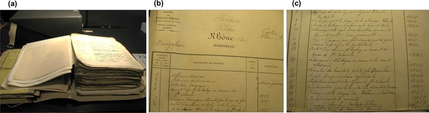
F. Arnaud et al.: Database on the French Rhône River (17th–20th century) 1943
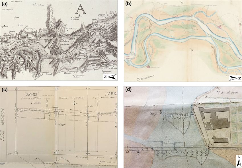
Figure 3. Examples of the archive resources collected in this study. (a) Map series at 1 : 28 246 between Geneva and the Guiers confluence,
1760. Extract of sheet no. 3/7 (source: De Bourcet, AD Savoie, 1Fi S52–53). (b) Map series at 1 : 10 000 from Geneva to the Mediterranean
Sea, 1842. Extract of sheet no. 20/25 (source: Arnaud, National Archives, CP/F/14/10074/2/Piece 8). (c) Long profile of the left bank and the
thalweg of the upper Rhône, 1869. Extract of sheet no. 6/6 (source: Ponts et Chaussées, AD Rhône, S 1356). (d) Bathymetric information on
a map at 1 : 2000 in Lyon, 1833 (source: Garella, AD Rhône, S 1361).
atically took pictures of iconographic resources, which in- 113 available for consultation. The box references con-
cluded maps (Fig. 3a, b), cross sections, long profile series sulted in all the archive services are listed in the dataset
(Fig. 3c), and topo-bathymetric information drawn on maps at https://doi.org/10.1594/PANGAEA.922437 (Arnaud et al.,
(Fig. 3d). 2020a).
The series CP (Maps and Plans Service) of the National All collected data were photographed on a table or on a
Archives was given special attention. This series contains magnetic board in the case of multiple-sheet and large doc-
older, larger and/or fragile maps, field surveys, and engineer- uments and were saved in .jpg format. The most interesting
ing structure iconographies, and requires specific authoriza- data were scanned at high resolution (.JPEG and .TIFF for-
tion for consultation (Fig. 3b), with the resources having to mat, up to 3 GB each).
be consulted one by one. Because of time constraints, we
focused on maps covering long river reaches rather than de-
3.2 Database structure
tailed maps of ports and cities and focused on reaches in-
volved in present river restoration projects, notably those Table 1 describes the properties of the 350 archived data
of Péage-de-Roussillon and Donzère-Mondragon. We se- items available in the Arnaud et al. (2020a) dataset. This ta-
lected 33 resources amongst the 53 available for consulta- ble has 18 columns that include the following: (1) the type of
tion in the sub-series CP/F/14/Streams and Rivers (6.5 p.). data, map, cross section, long profile, table, topo-bathymetry
The sub-series CP/F/14/Canals had 12 pages dealing with drawn on the map; (2) the source (archive service) and ref-
a project for a continuous lateral canal from Lyon to the erence (box number); (3) the original title (in French) and
Mediterranean Sea, which was finally dropped, and three a translated English title; (4) the scale, author, and sur-
pages dealing with the canal from Arles to Port-de-Bouc vey period; (5) the communes covered by the upstream–
at the Rhône delta. We selected 39 resources amongst the downstream kilometric points (KPs; km 0 is in Lyon, dis-
https://doi.org/10.5194/essd-13-1939-2021 Earth Syst. Sci. Data, 13, 1939–1955, 2021
1944                                                             F. Arnaud et al.: Database on the French Rhône River (17th–20th century)

Table 1. Extract of the .csv table describing the properties of the 350 archive resources collected in this study. The symbol ∼ in the Scale
column means that it was not provided in the document, and the scale was therefore estimated by direct measurement of the distance between
two benchmarks or by comparison with similar maps.

   (a)
   ID       Type          Source   Ref data              Original title (in French)          Translated title (in English)         Scale         Author(s)         Period
   44       Map           AD01     100Fi 67              Plan du cours du Rhône depuis       Map of the Rhône river from           Toises        NA            ∼ 1750
                                                         Seyssel jusqu’à Pierre-Châtel       Seyssel to Pierre-Châtel on the
                                                         sur le territoire de Virignin,      territory of Virignin and neigh-
                                                         ainsi que les communes avoisi-      bouring towns
                                                         nantes
   264      Map/cross AN           CP/F/14/10074/1/      Projet de halage pour le passage    Towing project for the Pont-St-       ∼ 1 : 5000    Grangent           1812
            section                A/piece25             du Pont-St-Esprit                   Esprit passage
   261      Map           AN       CP/F/14/10074/1/      Plan de la partie du cours du       Plan of the part of the Rhône         1 : 10 000    Grailly            1833
                                   B/piece34             Rhône et de la rive gauche de       river and the left bank of this
                                                         ce fleuve comprise dans le dé-      river included in the depart-
                                                         partement de la Drôme, entre        ment of the Drôme, between the
                                                         l’embouchure du ruisseau du         Dolon confluence (. . . ) and that
                                                         Dolon (. . . ) et celle du Lauzon   of the Lauzon
   96       Cross         AN       F/14/6501             Barrage du bras de Lavours          Dam of the Lavours channel            1 : 1000      O’Brien            1835
            section
   255      Map           AN       CP/F/14/10074/1/      Plan général de la rive droite du   General map of the right bank         1 : 10 000    Ponts and          1835
                                   B/piece35             cours du Rhône depuis Limony,       of the Rhône river from Limony                      Chaussées
                                                         jusqu’au pont de Saint-Just.        to the St-Just bridge. Third
                                                         Troisième feuille de Meisse à       sheet from Meisse to Saint-Just
                                                         St-Just
   304      Map/          AD69     S 1434                Amélioration du Rhône devant        Improvement of the Rhône river        1 : 10 000    Goux               1851
            bathy-                                       Beaucaire                           at Beaucaire
            metry
   100      Long          AD69     S1356                 Nivellement en long sur les         Longitudinal levelling on both        1 : 10 000    Ponts and          1869
            profile                                      deux rives du Rhône                 banks of the Rhône river                            Chaussées
   10       Map           CNR,     NA, 100Fi 69          Plans Branciard                     Branciard maps                        1 : 2000,     Branciard          1910
                          AD01     to 100Fi 114                                                                                    1 : 5000

  (b)
  Sector               Upstr.   Downstr.       Length    Comment                                        No. of    Image           Storage file          Sub-file
                         KP         KP           (km)                                                  images     acqui-
                                                                                                                  sition
  Seyssel to           −151        −117            34    This map may have been surveyed after              20    Table           1730-                 1750_NA_
  Virignin                                               the Sardinian Maps of 1738 and before                                    1875_Plans_           Seyssel-
                                                         1760 because “lateral lines” from 1760                                   UpperRhone            Virignin
                                                         are not visible everywhere
  Pont-St-               191        193             2    Names of the bridge piers. Three cross              8    Table           1756-1822_            PontStEsprit_
  Esprit                                                 sections                                                                 Grangent_Plans        1812
  St Rambert            61.5       191.5          130    Map of 12 m long. Name of some is-                 25    Table           1833_Grailly_
  to Pont-St-                                            lands but not their nature. Left bank                                    Plan_Dol-Lauz
  Esprit                                                 only. The Drôme River is visible
  Lavours             −131.5                  Ponctual   One cross section                                   8    Table           1799-                 1835_
                                                  data                                                                            1882_Topo-            OBrien_
                                                                                                                                  Bathy                 Lavours_CS
  Meysse to              151        191            40    Not the nature of bars and banks. Right            10    Table           1807-1858_            Meysse-
  St Just                                                bank only                                                                PontsChaussees_       StJust_1835
                                                                                                                                  Plans
  Beaucaire              260       268.5           8.5   Two general maps, three detailed maps         3, 6, 3,   Magnetic        1839-1853_            Beaucaire_1851
                                                                                                          3, 4    board           Goux_Plans
  Seyssel to           −150           0           150    Long profile indicating water depth and            14    Table           1869_PC_LP_
  Lyon                                                   thalweg elevation                                                        UpperRhone
  Virignin to         −116.5        219         335.5    Upstream of Lyon: AD01. Downstream           47, 107     HD              1910_Branciard_
  Caderousse                                             of Lyon: CNR (available on request)                      scan,           Plan_Viri-Cad
                                                                                                                  Georef
                                                                                                                  1st

Earth Syst. Sci. Data, 13, 1939–1955, 2021                                                                    https://doi.org/10.5194/essd-13-1939-2021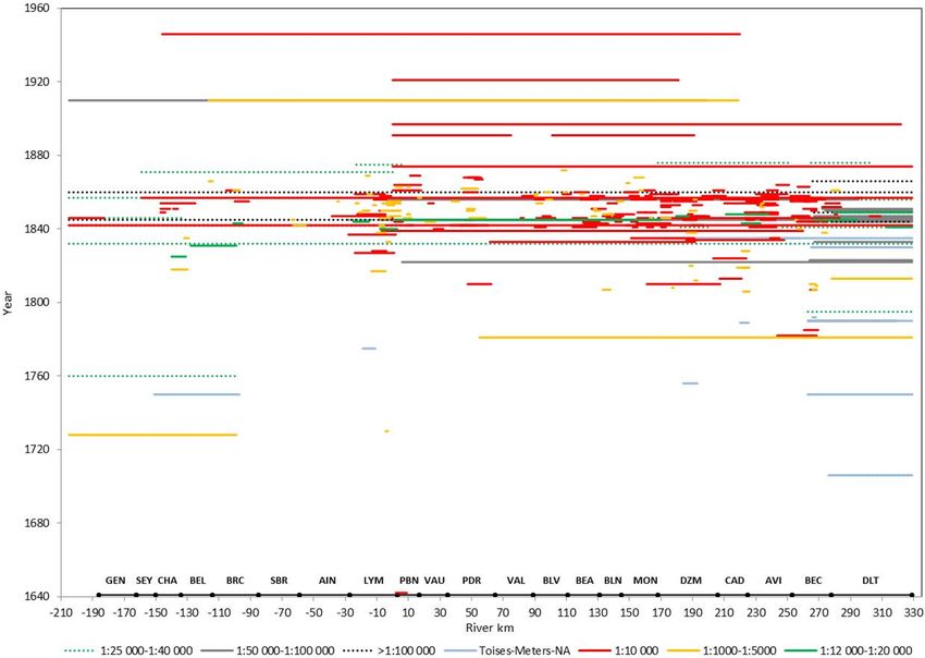
F. Arnaud et al.: Database on the French Rhône River (17th–20th century)                                                               1945

Figure 4. (a) Number of archive data items compiled in this study. “Other” corresponds to plans < 1 : 1000, long profiles of the Swiss Rhône,
and books. (b) Temporal extent of cartographic and topo-bathymetric data.

Figure 5. Map at ∼ 1 : 10 000 between Pierre-Bénite and Irigny, 1644 (source: Maupin, AD Rhône, 44 J 336).

tances upstream from this reference point are negative and               1 : 10 000 or 1 : 20 000 along a long river course (from 60
distances downstream are positive; the KPs were identified               to 530 km), e.g. the map by Josserand surveyed in 1845 be-
in ArcMap 10.5 using the GIS layer of riverine communes                  tween Lyon and Donzère (170 km long) or the long profile by
and active channels in 1860 to help in locating the maps with            the Ponts et Chaussées administration surveyed in 1869 from
secondary channels); (6) comments on the quality and con-                Seyssel to Lyon (151 km long; Fig. 3c). Three files consist
tent of the data; (7) the number of images and their type (on            of maps of the three main reaches of the Rhône: the French
a table or a magnetic board, HD scan, scanned; and georef-               upper Rhône (16 maps from 1730–1875), the middle-lower
erenced); and (8) the storage file and sub-file.                         Rhône (13 maps from 1642–1857), and the delta (16 maps
   The iconographic database available in Arnaud et                      from the 18th–19th century). Finally, the file “Topo-Bathy
al. (2020a) is 12.7 GB. It contains 3437 images stored in 32             (1799–1882)” contains 19 cross section and long profile se-
files and 342 sub-files. Thirteen files are named after the en-          ries surveyed by different authors.
gineer who did the surveys. For example, the “Kleitz (1853–                 The 350 archive resources include 330 maps and 93 topo-
1864)” and “Bouvier (1785–1848)” files contain 63 and 24                 bathymetric data items (Fig. 4a). About 40 other documents
sub-files, respectively. These files describe maps of different          were also collected, corresponding to plans (< 1 : 1000), in-
reaches, sometimes associated with topo-bathymetry data.                 formation on the Swiss Rhône, and books from the late 19th
The “Ponts et Chaussées (1807–1858)” file contains 37 maps               and early 20th century on fish populations (Vingtrinier, 1882;
surveyed by authors who are unknown or whose names                       Locard, 1901; Marchis, 1929). Maps and topo-bathymetric
are unreadable. The database also contains 14 files corre-               data mainly cover the 1840–1855 period (Fig. 4b), which cor-
sponding to a single engineer survey, generally at scales of             responds to the beginning of river training after the 100-year

https://doi.org/10.5194/essd-13-1939-2021                                                Earth Syst. Sci. Data, 13, 1939–1955, 2021
1946 F. Arnaud et al.: Database on the French Rhône River (17th–20th century)
Figure 6. Cross section at the suspension bridge of Beaucaire-Tarascon. The low-flow water level deduced from the Beaucaire gauging
station and the water level on the day of the survey (5 September 1854) are indicated in blue (source: Aymard, AD Rhône, S 1434).
flood in October 1840. This flood was responsible for signif- 3.3 GIS integration
icant damage and led to the establishment of the Rhône Spe-
cial Service within the Ponts et Chaussées administration in The longitudinal coverage of each of the 350 data items was
1840 (Bravard, 2010). The 1856–1870 period was also well positioned along the Rhône River centreline in ArcMap 10.5,
surveyed, following the other 100-year flood in May 1856. according to the upstream and downstream KPs. The indi-
Nineteen percent of the database covers the 1640–1839 pe- vidual coverages were then merged into one polyline layer
riod. The oldest resource is a series of six maps found in the available in the Arnaud et al. (2020a) dataset. This layer pro-
Chaponnay private archive of AD Rhône, surveyed in 1642– vides efficient identification, with a single click, of archive
1660 and depicting the “brotteaux” (grazing areas on recent resources available for a given reach. For example, dragging
alluvial deposits) between Pierre-Bénite and Irigny fluvial a selection box over the Chautagne bypassed reach (KP −146
ports to the south of Lyon (Fig. 5). This map series represents to −137) displays 24 data items on this reach (Fig. 9).
the Rhône River in an artistic manner; however, the distances The Arnaud et al. (2020a) dataset provides 14 scanned
between villages were checked and were found to be realis- map series, in both raw (.JPEG or .TIFF) and georeferenced
tic. (.GeoTIFF) formats (Table 2). They are among the most spa-
Hydrological information like spatial extent of large floods tially extensive and accurate maps in terms of the features
and the associated water level at gauging stations is provided represented. Half of these maps have been georeferenced
on most maps. On the other hand, the discharge of the aquatic in previous works of the Rhône observatories, using a first-
channel is rarely given, and we have to assume that the river order polynomial transformation (between 3 and 15 ground
is represented at its mean annual discharge, as is usual in control points (GCPs) per image; RMS error up to 50 m). In
cartography. Only few maps, like the “Topographical map this study, we tested the spline transformation (named thin-
of the Rhône River” surveyed in 1857–1876 by the Ponts et plate spline transformation in QGIS) based on the recom-
Chaussées administration indicate in the chart legend that the mendations of Lestel et al. (2018) for old maps. The spline
channel was mapped at the mean annual discharge. Finally, transformation is a true rubber-sheeting method optimized
water level information is systematically provided on topo- for local but not global accuracy. It transforms the source
bathymetric data, the water level on the day of the survey, GCPs exactly to the target GCPs, with minimal error around
the low-flow level, and/or the high flood levels (Fig. 6). the points. The spline transformation is therefore useful when
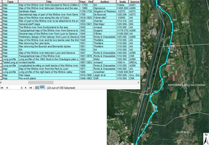
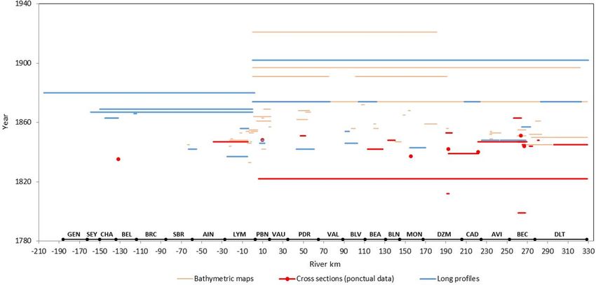
Figure 7 provides a synoptic view of all cartographic data the number of GCPs is important (https://www.esri.com/; last
with corresponding spatial scales along the Rhône River. access: 2 May 2021). The spline transformation was tested
Most items were surveyed between the scales of 1 : 1000 on map series of 1760 and 1831 by adding GCPs and was
and 1 : 20 000, with 1 : 10 000 being used most often. This compared with the polynomial transformations (Table 2).
latter scale is suitable for quantitative analysis of morpho- The positioning on the present orthophotograph was signif-
ecological units. Similarly, Fig. 8 depicts the longitudinal icantly improved, and the spline transformation was there-
coverage of topo-bathymetric data. fore applied to the newly collected maps. Raw and georef-
erenced images are usable in both ArcGIS and QGIS soft-
wares. Among the 316 other maps of the database, most
Earth Syst. Sci. Data, 13, 1939–1955, 2021 https://doi.org/10.5194/essd-13-1939-2021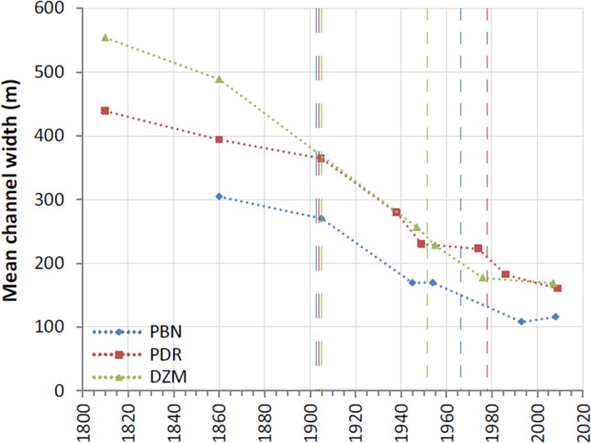
F. Arnaud et al.: Database on the French Rhône River (17th–20th century)                                                             1947

Figure 7. Longitudinal coverage and spatial scales of the cartographic dataset. The spatial extent of present river reaches is superimposed
on the x axis (see Fig. 1 for acronyms).

Figure 8. Longitudinal coverage of the topo-bathymetric dataset. The spatial extent of present river reaches is superimposed on the x axis
(see Fig. 1 for acronyms).

https://doi.org/10.5194/essd-13-1939-2021                                               Earth Syst. Sci. Data, 13, 1939–1955, 2021
1948                                                              F. Arnaud et al.: Database on the French Rhône River (17th–20th century)

Table 2. Georeferencing information on 14 map series of the database. The BD ORTHO® and PARCELLAIRE® base maps are provided
by the IGN.

  Translated title (in English)          Scale    Author(s)   Period    Sector       Length   No. of   Georeferencing No. GCPs      RMS         Base map
                                                                                       (km)    img.    transformation per img.      error
                                                                                                                                    (m)
  Map of part of the Rhône           1 : 30 000   NA          18th      Yenne to        25        2    Spline         12–24         10−5        BD ORTHO® and
  river from Cordon to                                        century   Cordon                                                                  PARCELLAIRE® ,
  Hyenne (. . . )                                                                                                                               © OpenStreetMap
  Geometrical map of part            1 : 28 246   De          1760      Genève         107        7    1st-order      13–25 and     34–44 and   BD ORTHO® and
  of the Rhône river from                         Bourcet               to                             polynomial     20–26         10−5        PARCELLAIRE® ,
  Geneva to the Guyer con-                                              St-Genix                       and spline                               © OpenStreetMap
  fluence (. . . )
  Map of the marshes and          ∼ 1 : 100 000   Delisle     Late      Beaucaire       57        1    Spline         31            10−5        BD ORTHO® and
  the plain from Beaucaire to                                 18th      to the sea                                                              PARCELLAIRE® ,
  Aiguemortes (. . . )                                        century                                                                           © OpenStreetMap
  Napoleonic land register           1 : 10 000   Napoleon    1810–     St-            63.5      16    1st-order      NA            NA          BD ORTHO® and
                                                  I           1832      Maurice                        polynomial                               PARCELLAIRE®
                                                                        to Pio-
                                                                        lenc
  The Rhône river: border            1 : 14 400   Corefa      1831      Cressin         30        1    1st-order      23 and 38     59 and      BD ORTHO® and
  between the Kingdom of                                                to                             polynomial                   10−5        PARCELLAIRE® ,
  France and the Duchy of                                               St-Genix                       and spline                               © OpenStreetMap
  Savoy
  General plan and project for       1 : 10 000   Dignoscyo 1837        Jons to         31        2    Spline         50–85         10−5        BD ORTHO® and
  the dyke to be built against                                          Pierre-                                                                 PARCELLAIRE® ,
  the highest floods of the                                             Bénite                                                                  © OpenStreetMap
  Rhône (. . . )
  Map of the Rhône river be-         1 : 10 000   Ponts     1846        Donzère        116       12    Spline         19–52         10−5        BD ORTHO® and
  tween Donzère and Arles                         and                   to Arles                                                                PARCELLAIRE® ,
                                                  Chaussées                                                                                     © OpenStreetMap
  NA                                 1 : 10 000   NA          1854      Anglefort       23        5    Spline         10–14         10−5        BD ORTHO® and
                                                                        to Mas-                                                                 PARCELLAIRE® ,
                                                                        signieux                                                                © OpenStreetMap
  Topographical map of the           1 : 10 000   Ponts     1857–       Surjoux        489       58    1st-order      ∼ 15          < 50        BD ORTHO®
  Rhône river                                     and       1876        to the sea                     polynomial     Improvement   Improvement
                                                  Chaussées                                                           of 9 im-      of 9 im-
                                                                                                                      ages:         ages:
                                                                                                                      10–17         4.6–12.8
  Completion and first main-         1 : 10 000   Girardon    1891      Lyon to       169.5      55    1st-order      6–15          3.0–9.5     BD ORTHO®
  tenance works                                                         Donzère                        polynomial
  Bathymetric maps of the            1 : 10 000   Ponts     1897–       Lyon to        307       66    1st-order      4–12          0.6–20.5    BD ORTHO®
  Rhône river                                     and       1908        the sea                        polynomial
                                                  Chaussées
  Branciard maps                      1 : 2000,   Branciard   1910      Virignin       170      107    1st-order      3–15          0.3–11.3    BD ORTHO® and
                                      1 : 5000                          to Cader-                      polynomial                               PARCELLAIRE®
                                                                        ousse
  General staff maps                1 : 20 000–   Etat-       1832–     Genève         535      162    1st-order      4–6           0.8–26.3    BD ORTHO®
                                     1 : 80 000   Major       1941      to the sea                     polynomial
  Pre-work plans                     1 : 10 000   CNR         1946–     Anglefort      162      128    1st-order      4             NA          BD ORTHO®
                                                              1983      to Cader-                      polynomial
                                                                        ousse

can be georeferenced by using riverine roads, buildings, and                             4    Data use and application
dykes as GCPs. When available, land register can also be
used. Though, maps surveyed at a too large scale (1 : 1000,
                                                                                         The type of archive data, either manually photographed or
1 : 2000), or those representing a single bank of the Rhône
                                                                                         scanned, and in some cases georeferenced, allows the user a
River, do not have enough GCPs to be georeferenced.
                                                                                         qualitative or quantitative analysis, including illustration of
                                                                                         the fluvial landscape of a large river at the beginning of the
                                                                                         19th century, evaluation of the main transformations follow-
                                                                                         ing river regulation, and diachronic GIS extraction of met-

Earth Syst. Sci. Data, 13, 1939–1955, 2021                                                                      https://doi.org/10.5194/essd-13-1939-2021
F. Arnaud et al.: Database on the French Rhône River (17th–20th century) 1949 Figure 9. GIS layer of the longitudinal coverage of data collected in this study. Example of the 24 available data items on the Chautagne river reach (KP −146 to −137). Basemap: Esri. rics such as channel widths, secondary channel numbers, and flood were drawn in light orange. Note that the titles of the gravel bar areas. The scanning and georeferencing of the maps are equivocal: 71 maps of the database have the word sources are not exhaustive. The archive references are accu- “dyke” in their title and were surveyed to report damages rately described in the table of data properties to facilitate after large floods, rebuild dykes, or design new ones. The easy consultation and scanning of data of interest. challenge of map-based historical studies is to use individ- The dataset depicts heterogeneous information, which de- ual sources over time, with sometimes little information on pends on the survey date and map objectives. A critical anal- the context in which the map was created and therefore on its ysis should therefore be carried out before any use of the certainty level. The comparison of multiple maps available at dataset on a given river reach. As an example, Fig. 10 com- close dates (some of them surveyed in the same year by dif- piles maps surveyed in the upstream section of the Donzère- ferent engineers) allows inconsistencies between individual Mondragon (DZM) reach, which is currently involved in side sources to be resolved while revealing persistent landscape channel reconnections, riprap removal, and gravel augmen- features and patterns (Safran et al., 2017). For example, the tation. The 5 km long section (KP 171 to 176) embraces coloured map of 1842 from Switzerland to the Mediterranean the eastern Bayard secondary channel, which was the main Sea surveyed by the engineer Arnaud is fairly aesthetic; how- course of the river in the late 18th century. Among the 26 ever, a comparison with other maps highlights the lack of ac- maps available prior to 1860, nine have been selected at curacy in the depiction of geomorphic features, notably on scales of 1 : 5000–1 : 10 000. Maps from 1810 to 1842 do not the downstream part of the Bayard channel, as well as the specify the nature of islands. Partial information is given on non-exhaustive mapping of roads and villages, which lim- the 1843 map, with gravel bars drawn in light orange. Sym- its the number of ground control points available for georef- bols are then used on the 1846 map to differentiate gravel erencing. In addition, when analysing long-term vegetation bars and vegetated areas. These symbols are also used on the changes, it is important to carefully examine vegetated area 1852 and 1856 maps; their base map is the 1846 edition su- representation (when available) because vegetation could be perimposed with the new channel pattern and engineering in- represented in many different ways, either by colours, sym- frastructure, which is a common practice in engineering car- bols, or annotations (Figs. 10 and 11). In most cases, only tography (Lestel et al., 2018). The 1856 map was edited to vegetated islands and the riparian vegetation close to the report damage to “unsubmersible” dykes after the flood of channel were mapped (Fig. 11a and b). The depiction of veg- May 1856. New islands and gravel bar areas formed after the etation in the entire floodplain was less frequent (Fig. 11c), https://doi.org/10.5194/essd-13-1939-2021 Earth Syst. Sci. Data, 13, 1939–1955, 2021
1950                                              F. Arnaud et al.: Database on the French Rhône River (17th–20th century)

Figure 10. Examples of maps surveyed on the upstream section of the Donzère-Mondragon reach, 1810–1860. The present Rhône centreline
is superimposed on the 1810, 1846, and 1860–2020 georeferenced maps. The scale is given by the spacing between the kilometric points
(KPs) on these maps. The 1860–2020 map shows the present orthophotograph, on which the delineations of aquatic channels in 1860 were
superimposed (Source: 1810: Napoleonic Land Register; 1835, 1846, 1856 and 1860: Ponts et Chaussées; 1842: Arnaud; 1843: Bouvier;
1849 and 1852: Goux; 2020: Esri).

especially regarding vegetation types (grassland, shrubs, for-      had been collected until now. The archives prior to 1860 pro-
est, agricultural areas; Fig 11d). Note that the more recent        vide us with historical benchmarks for process-based river
maps did not have systematically more information than the          restoration and permit comparisons with other rivers with
older ones.                                                         available archives. A potential application could be the de-
   Keeping in mind the preliminary examination of the data          tailing of past trajectories of floodplain units, such as that
accuracy, the large number of historical data items collected       performed by Tena et al. (2020) on three bypassed reaches
in this study should enable deeper analyses of channel shift-       of the middle and lower Rhône (Fig. 12). Similarly, Dépret
ing, island dynamics, and landscape changes over a longer           et al. (2017) combined historical maps and aerial images
time period and at a finer time step than those performed           (1860–2009) to date a series of channel disconnections and
in previous studies and also on many reaches of the Rhône           study terrestrialization processes. They showed that terres-
River and tributary confluences for which no historical maps        trialization of naturally cut-off channels was much quicker

Earth Syst. Sci. Data, 13, 1939–1955, 2021                                          https://doi.org/10.5194/essd-13-1939-2021
F. Arnaud et al.: Database on the French Rhône River (17th–20th century)                                                          1951

Figure 11. Examples of vegetation representation from the simplest to the most detailed: (a) island annotation: “saulée” in French means
“willows”, “gravier” means “gravel” (source: Goux, 1851, AD Rhône, S 1393); (b) riparian vegetation close to the channel (source:
Kleitz, 1856, AD Rhône, S 1397); (c) depiction of vegetation in the floodplain (source: unknown author, 18th century, National Archives,
CP/F14/10074/1/A/Piece3); (d) differentiation between vegetation types (source: Bouvier, 1844, National Archives, F/14/6583).

                                                                      initiated by Bravard et al. (1986) and Roux et al. (1989) on
                                                                      the upper Rhône section. During the 18th and 19th centuries,
                                                                      the backswamps and the gravel bars of the braided belt were
                                                                      devoted to extensive grazing, and the woody islands were cut
                                                                      every five years for supplying the riverine populations and
                                                                      the town of Lyon with fuel. On the margins of the floodplain,
                                                                      a few hardwood forests of Fraxinus excelsior, Quercus robur,
                                                                      and Acer pseudoplatanus escaped land clearances for pas-
                                                                      ture, subsistence agriculture, and firewood cutting (Roux et
                                                                      al., 1989). More recently, Janssen et al. (2020) showed from
                                                                      aerial images that the critical changes undergone by the ri-
                                                                      parian forests of the Rhône River under persistent multiple
                                                                      stressors, strongly diverged from near-natural systems dur-
                                                                      ing the 20th century.
                                                                         Historical maps and associated physical data have been
                                                                      used to assess fish-faunistic reference conditions in the
Figure 12. Temporal variation in the mean active channel width of     framework of European biomonitoring improvement (Wolter
three reaches of the Rhône between 1810 and 2009. Long dashed         et al., 2005; Ramos-Merchante et al., 2021). An historical
lines correspond to the Girardon training phase and short dashed
                                                                      analysis (from the end of the 19th century) of fish commu-
lines correspond to the channel bypassing for each reach (Tena et
al., 2020).
                                                                      nity structure in the Seine River catchment highlighted the
                                                                      major role of river continuity alteration in the decline of
                                                                      migratory species, the importance of introductions of non-
                                                                      native species, and changes in the proportion of rheophilic
than that observed on artificially cut-off channels, probably         and eurytopic species in relation to the increase of human
because of much higher bedload transport, which promoted              population and water pollution (Belliard et al., 2018). His-
active sediment infilling. The historical dataset is also valu-       torical data on fish communities along the Rhône River were
able to explore longer-term ecological succession, such as            discussed by Carrel (2002). In addition to fish data, Léger’s

https://doi.org/10.5194/essd-13-1939-2021                                             Earth Syst. Sci. Data, 13, 1939–1955, 2021
1952 F. Arnaud et al.: Database on the French Rhône River (17th–20th century)
maps available in the Arnaud et al. (2020a) dataset also pro- indicated as “available on request” because of specific reuse
vide morphological information on each river section (mean policies of these institutions. The URLs of each institution’s
channel width, mean water depth). Combining physical data reuse policy are given in Pangaea metadata.
describing habitat heterogeneity (channel width, river bank Extracts of the 350 data items are available in the public
length, diversity, and accessibility of floodplain channels; see photo gallery of the Rhône Valley Human-Environment Ob-
Hohensinner et al. 2004, 2011, for examples on the Danube servatory (http://photo.driihm.fr/index.php/category/52, last
River) at different periods with data on fish habitat prefer- access: 2 May 2021) to enhance data visibility. This photo
ences (Lamouroux et al., 1999; Rifflart et al., 2009) may be gallery uses the open source Piwigo software, with images
useful to achieve a better understanding of the influence of being geolocated on an interactive map. Map extracts have
fluvial landscape transformation over the last few centuries been oriented according to the flow direction of the Rhône,
on fish abundance and spatial patterns. More generally, the as long as this did not disturb the toponym reading.
combination of biotic and abiotic archival data is important In addition to Pangaea, technical information on the
to assess how changes in hydromorphological river condi- dataset is available in the public metadata catalogue
tions influenced biodiversity. of the Rhône Valley Human-Environment Observatory
Finally, another potential use of the dataset is the recon- (http://elvis.ens-lyon.fr/geonetwork/srv/eng/catalog.search#
struction of extreme flood events based on historical chan- /metadata/6b60389a-92da-4353-b4d9-9280d0638f5f,
nel geometries. The Beaucaire-Tarascon station (KP 269.5) last access: 2 May 2021). Based on the open source
records flows of the whole basin and is the oldest hydro- GeoNetwork software, this metadata catalogue is har-
metric station on the Rhône. Daily water level measurements vested by the LabEx DRIIHM (international consor-
started in 1816 and daily estimates of discharge started in tium of Human-Environment Observatories) geocata-
1920 (Billy et al., 2018). These chronicles are part of the logue (http://ccwbvps01.in2p3.fr:8080/geonetwork/srv/
HISTRHONE database, which contains a large volume of eng/catalog.search#/search?from=1&to=20&sortBy=
archives related to hydroclimatic events in the lower Rhône changeDate&fast=index&_content_type=json, last access:
over a period between the 14th and 20th century (Pichard and 2 May 2021), which is then harvested by the French
Roucaute, 2014). Further work by hydrologists will involve geocatalogue (http://www.geocatalogue.fr/, last access:
exploiting historical topographic data prior to river training to 2 May 2021) and the European INSPIRE Geoportal
reduce uncertainties in the extrapolation of rating curves of (https://inspire-geoportal.ec.europa.eu/, last access: 2
hydraulic modelling based on original channel geometries. May 2021), so that data discovery is possible at several
The topo-bathymetric data highlighted in this study will be hierarchical levels (Arnaud et al., 2020b).
of particular interest (Figs. 6 and 8).
6 Conclusions
5 Data availability
This study presents a historical database of 350 maps, topo-
The dataset is freely available in Pangaea at bathymetric cross sections, and long profiles compiled on
https://doi.org/10.1594/PANGAEA.922437 (Arnaud et the French Rhône River over the 1640–1950 period. Such
al., 2020a). It contains the iconographic database (12.7 GB), an inventory of historical data over such a long time period
the .csv table describing the properties of the 350 data and long river course (530 km) has never been created for
items (109 KB), the .csv table listing the 281 archive box the Rhône and has rarely been created for other large rivers.
references (13 KB), and the GIS layer of the longitudinal This database will enable further comparisons with other
coverage of the 350 data items (10.8 MB). The dataset multi-impacted large rivers in Europe, such as the Danube,
is available under the terms of the Creative Commons the Rhine, the Ebro, and the Po, or even from one conti-
Attribution-NonCommercial (CC BY-NC) license, which nent to another when data are available. The densification of
permits use, distribution, and reproduction in any medium, archived time series is useful to detail and extend past trajec-
provided that the use is not for commercial purposes and that tories of geomorphic, hydraulic, and ecological river features
the original work is properly cited. This license was chosen and for conducting comparative analyses to detect differ-
to meet the data reuse policies of the 14 French archive ences and similarities between reaches and between rivers lo-
services investigated in this study, four of which have a reuse cated in different geographical settings. Recently, rehabilita-
policy equivalent to the CC BY license (National Archives, tion measures have been extended to other bypassed reaches
AD Ain, AD Vaucluse, DREAL, Univ. Grenoble) and five of the lower Rhône River (Baix-le-Logis-Neuf, Saint-Vallier,
of which have a reuse policy equivalent to the CC BY-NC Montélimar) and these will also require analyses of chan-
license (BnF, AD Rhône, AD Drôme, AD Ardèche, AD nel changes over the last two centuries to design restoration
Gard). Ten items among the 350 items in the dataset were objectives. Some archive services were consulted in entirety
collected from AD Isère, AD Savoie, CNR, and IGN and for the time period and theme of this data article, notably the
they are not furnished in the iconographic database. They are National Archives and AD Rhône, whereas additional inves-
Earth Syst. Sci. Data, 13, 1939–1955, 2021 https://doi.org/10.5194/essd-13-1939-2021F. Arnaud et al.: Database on the French Rhône River (17th–20th century) 1953
tigations could be conducted in CNR or other departmental References
archives in coming years. Possible updates or extensions to
the dataset might therefore happen in the future.
Amoros, C. and Bornette, G.: Connectivity and biocomplexity in
waterbodies of riverine floodplains, Freshw. Biol., 47, 761–776,
Author contributions. All co-authors actively participated in the
2002.
project “Collection and visualization of historical biophysical re-
Arnaud, F., Sehen Chanu, L., Grillot, J., Riquier, J., Pié-
sources on the Rhône River” (OHM Vallée du Rhône, 2017–2019).
gay, H., Roux-Michollet, D., Carrel, G., and Olivier, J.
Fanny Arnaud and Lalandy Sehen Chanu searched archive ser-
M.: Cartographic and topo-bathymetric archive dataset on
vices, photographed historical resources, and prepared the database.
the French Rhône River (17th–20th centuries), PANGAEA,
Jules Grillot performed the GIS treatment of scanned data. Jérémie
https://doi.org/10.1594/PANGAEA.922437, 2020a.
Riquier brought his expertise on historical data from previous
Arnaud, F., Lerigoleur, E., Jean-Charles, A., Le Berre, I., Pardo,
long-term research on the Rhône River. Fanny Arnaud super-
C., Raynal, J. C., Fozzani, J., Michel, K., Trémélo, M. L., and
vised the project and wrote the manuscript. Hervé Piégay, Dad
Roux-Michollet, D.: Managing and sharing multidisciplinary in-
Roux-Michollet, Jérémie Riquier, Georges Carrel, and Jean-Michel
formation in human-environment observatories: feedbacks and
Olivier revised the manuscript and provided important contributions
recommendations from the French DRIIHM network, Jour-
in the section “Data use and application”.
nal of Interdisciplinary Methodologies and Issues in Sciences,
https://doi.org/10.18713/JIMIS-120620-6-3, 2020b.
Arnaud, F., Piégay, H., Schmitt, L., Rollet, A. J., Ferrier, V.,
Competing interests. The authors declare that they have no con- and Béal, D.: Historical geomorphic analysis (1932–2011)
flict of interest. of a by-passed river reach in process-based restoration per-
spectives: The Old Rhine downstream of the Kembs diver-
sion dam (France, Germany), Geomorphology, 236, 163–177,
Acknowledgements. This research was funded by the OHM https://doi.org/10.1016/j.geomorph.2015.02.009, 2015.
Vallée du Rhône in the LabEx DRIIHM French program “In- Arnaud-Fassetta, G.: River channel changes in the Rhone Delta
vestissements d’Avenir”, managed by the Agence Nationale de la (France) since the end of the Little Ice Age: geomorphological
Recherche (ANR). The work was performed in the EUR H2O’Lyon adjustment to hydroclimatic change and natural resource man-
(ANR-17-EURE-0018) of Université de Lyon. Data were collected agement, Catena, 51, 141–172, https://doi.org/10.1016/S0341-
in Archives Nationales (France), Bibliothèque nationale de France, 8162(02)00093-0, 2003.
Archives départementales du Rhône et de la métropole de Lyon, Belletti, B., Dufour, S., and Piégay, H.: What is the relative ef-
Archives départementales de l’Ain, Archives départementales du fect of space and time to explain the braided river width and
Gard, Archives départementales de la Savoie, Archives départemen- island patterns at a regional scale?, River Res. Appl., 31, 1–15,
tales de l’Isère, Archives départementales du Vaucluse, Archives https://doi.org/10.1002/rra.2714, 2013.
départementales de l’Ardèche, Compagnie Nationale du Rhône, Di- Belliard, J., Beslagic, S., Delaigue, O., and Tales, E.: Recon-
rection Régionale de l’Environnement, de l’Aménagement et du Lo- structing long-term trajectories of fish assemblages using his-
gement Auvergne-Rhône-Alpes, Institut National de l’information torical data: the Seine River basin (France) during the last
Géographique et forestière, and Université de Grenoble. We thank two centuries, Environ. Sci. Pollut. Res., 25, 23430–23450,
colleagues from EVS involved in archive data collection since https://doi.org/10.1007/s11356-016-7095-1, 2018.
2009: Guillaume Fantino, Pauline Gaydou, Elsa Parrot, Bianca Räp- Billy, P., Bard, A., Lang, M., Naulet, R., and Mallet, T.: Up-
ple, and Nicolas Talaska. Mathieu Lucas provided useful infor- dating flood assessment of the Rhône river, a new method-
mation on the Rhône hydrology. We thank Nadine Gastaldi and ology, in: Proceedings, 3rd International Conference, Integra-
Stéphane Rodriguez-Spolti from the Maps and Plans Service of tive Sciences and Sustainable Development of Rivers, Lyon,
National Archives for their help in the consultation of documents. France, June 2018, 4–8, available at: https://www.graie.org/
Karl Embleton proofread the manuscript. ISRivers/docs/ISRIVERS2018_Actes_web.pdf (last access: 19
May 2020), 2018.
Bravard, J. P., Amoros, C., and Pautou, G.: Impact of civil engi-
Financial support. This research has been supported by the neering works on the successions of communities in a fluvial
Agence Nationale de la Recherche (grant no. ANR-11-LABX- system: a methodological and predictive approach applied to a
0010). section of the upper Rhône River, France, Oikos, 47, 92–111,
https://doi.org/10.2307/3565924, 1986.
Bravard, J. P.: Discontinuities in braided patterns: The
Review statement. This paper was edited by David Carlson and River Rhône from Geneva to the Camargue delta be-
reviewed by Hanna Hajdukiewicz and one anonymous referee. fore river training, Geomorphology, 117, 219–233,
https://doi.org/10.1016/j.geomorph.2009.01.020, 2010.
Cadol, D., Rathburn, S. L., and Cooper, D. J.: Aerial pho-
tographic analysis of channel narrowing and vegetation ex-
pansion in Canyon de Chelly National Monument, Ari-
zona, USA, 1935–2004, River Res. Appl., 27, 841–856,
https://doi.org/10.1002/rra.1399, 2011.
https://doi.org/10.5194/essd-13-1939-2021 Earth Syst. Sci. Data, 13, 1939–1955, 2021You can also read