Participant Handbook 2021 - MISSOURI BUMBLE BEE ATLAS
←
→
Page content transcription
If your browser does not render page correctly, please read the page content below
Participant Handbook - 2021
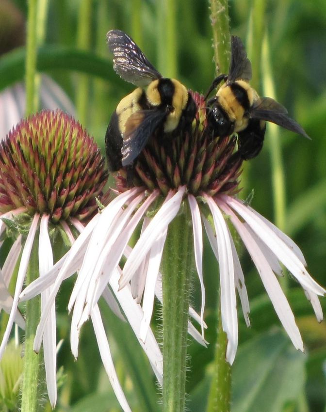
Project Coordinators:
Katie Lamke                                                Rich Hatfield
Bumble Bee Conservation Specialist                         Senior Conservation Biologist
The Xerces Society for Invertebrate                        The Xerces Society for Invertebrate
Conservation                                               Conservation
Lincoln, NE 68583                                          Portland, OR 97221
Phone: (707) 477-2224                                      Phone: (503) 232-6639 x115
katie.lamke@xerces.org                                     rich.hatfield@xerces.org

Bill White                                                 Deborah Finke
Community and Private Land Conservation                    Associate Professor of Plant Sciences
Branch Chief                                               University of Missouri
Missouri Department of Conservation                        Columbia, MO 65211
Jefferson City, MO 65102                                   Phone: (573) 884-5125
Phone: (573) 555-1212                                      finked@missouri.edu
bill.white@mdc.mo.gov

Casey Bergthold
Missouri State Coordinator
Pheasants Forever Inc., and Quail
Forever
Paris, MO 65275
Phone: (573) 823-0675
cbergthold@quailforever.org

Project Resources:
www.MOBumbleBeeAtlas.org

Cover photo: Southern Plains Bumble Bees (Bombus fraternus) on Coneflower (Echinacea sp).
Photo by Jennifer Hopwood / Xerces Society.
Contents
Introduction ................................................................................................. 4
Bumble Bee Biology ........................................................................................ 6
Project Design .............................................................................................. 8
  Tracking Your Efforts.................................................................................... 9
  Atlas Survey Blitz ........................................................................................ 9
  Endangered Species .................................................................................... 10
How to Participate ........................................................................................ 11
  Step 1: Register ......................................................................................... 11
  Step 2: Adopt a Grid Cell .............................................................................. 11
  Step 3: Get Familiar With Project Protocols ........................................................ 12
  Step 4: Conduct a Survey .............................................................................. 12
  Step 5: Submit Your Data .............................................................................. 14
Survey Methods ............................................................................................ 20
  Point Surveys ............................................................................................ 21
  Roadside Surveys........................................................................................ 23
  Habitat Assessments .................................................................................... 25
  Alternative Survey Options ............................................................................ 26
Supplies ..................................................................................................... 28
Resources ................................................................................................... 29
Data Sheets and Field Guides ............................................................................ 31
Missouri Dept. of Conservation Volunteer Agreement ............................................... 41

3|Page
Introduction
Bumble bees are charismatic and easily recognizable pollinators thanks to their large size,
loud buzz, and distinctive color patterns of black and yellow, though often red, orange, or
white too. They play an incredibly important role in sustaining the health of our environment
by pollinating flowers in natural and urban areas, and by contributing to successful harvests
on farms.

To help understand and conserve our state’s bumble bees, the Missouri Department of
Conservation, Pheasants Forever and Quail Forever, and the University of Missouri have
partnered with the Xerces Society to create the Missouri Bumble Bee Atlas. The Atlas is a
statewide community science project, meaning anyone can get involved and take an active
role in pollinator conservation. Our team of community scientists, hopefully including you,
will work alongside researchers to better understand the status, distribution, and habitat
needs of Missouri’s bumble bees.

The variety of Missouri’s ecosystems supports about 13 different species of bumble bees. A
few of these species, such as the Southern Plains Bumble Bee (Bombus fraternus), are in
trouble and face an uncertain future. A recent study led by the International Union on
Conservation of Nature’s Bumble Bee Specialist Group—supported by studies led by Dr. Sydney
Cameron—and a status review by the late Dr. Robbin Thorp and the Xerces Society,
demonstrate that one quarter of North America’s nearly fifty species of bumble bees are
undergoing dramatic population declines.

The causes of these declines are not fully understood, but the following are likely
contributing: habitat loss, degradation or fragmentation, pesticide use, climate change, low
genetic diversity, and pathogens. Regardless of the ultimate cause of bumble bee declines,
protecting and managing existing habitat or creating new habitat are some of the most
immediate and productive steps that can be taken to conserve these important pollinators.
That’s where the Atlas comes in.

In working together to collect data on bumble bees and the surrounding habitat, we will be
able to identify areas in Missouri that are supporting bumble bees and those in need of
restoration or management. Understanding how species distributions have changed over time,
in conjunction with habitat change, will help form accurate predictions as to what we should
expect in the future, and aid in the design of effective conservation measures.

However, because Missouri is large and diverse, collecting these data will require widespread
participation and collaboration by landowners, agencies, scientists, and you.
With your help, we can quickly cover the entire state, collect scientific-quality data, and
contribute to bumble bee conservation. Our effort will help conservation biologists,
restoration practitioners, and policy makers do a better job protecting, restoring, and
managing effective habitat that support healthy bumble bee populations.
Training is offered to provide you with the necessary resources, skills, and confidence to
conduct your own bumble bee surveys as a community scientist.

4|Page
We invite you to join the project; participation is easy:
1. Attend a training event
Live webinar (https://www.mobumblebeeatlas.org/events.html)
On your own time using the Online Training Portal
(www.mobumblebeeatlas.org/train-online)
2. Adopt a grid cell
Alone or with a small group of people
3. Conduct 2 formal surveys within your grid cell between June-Sept
One formal survey includes a bumble bee survey and a habitat survey, each
following standardized protocol we have laid out. The minimum requirement is
2 formal surveys, but more surveys are welcomed!
4. Submit your data online using our website and Bumble Bee Watch
What you will need to participate:
1. A curiosity for insects and flowers
2. Transportation to your grid cell (or choose an area in which you live or work)
3. A camera or smartphone to take high quality pictures
4. Access to a computer or smart phone where you can upload photos to Bumble Bee
Watch and track your progress
Items that are helpful to participate:
1. An insect net and vials (glass jars from home work well)
2. Basic knowledge of wildflower identification and where to find them
3. Local plant identification field guides
4. Bumble bee field guides (Bumble Bees of North America)
For a list of workshop events, online training material, purchasing links and more, visit:
www.MOBumbleBeeAtlas.org
Join us on social media:
5|Page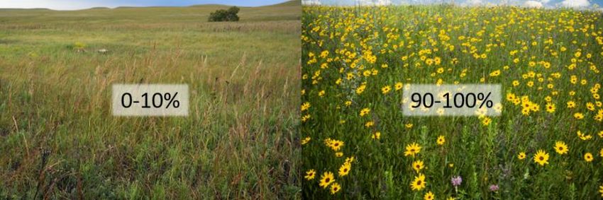
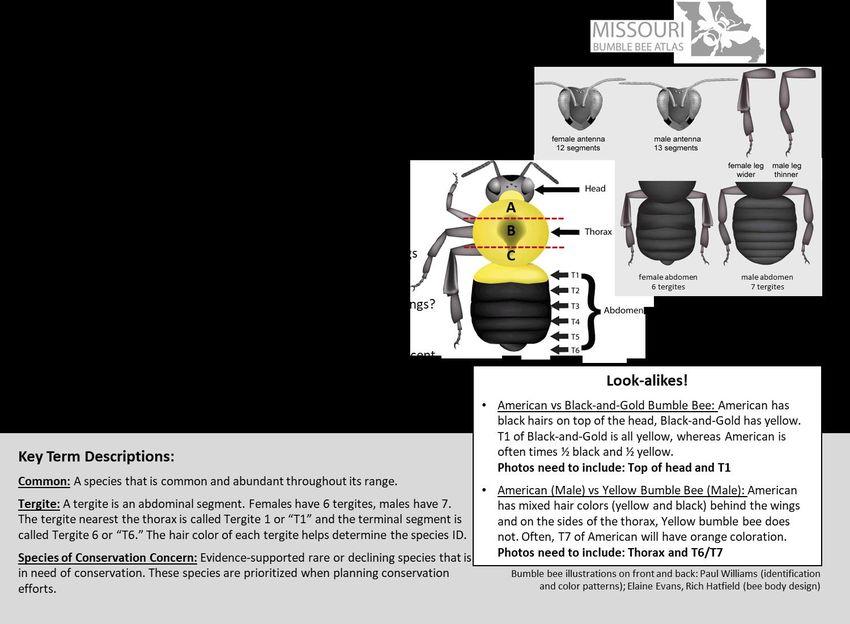
Bumble Bee Biology
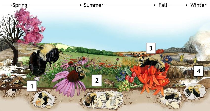
Life Cycle
Bumble bees are social insects that live in colonies like honey bees, although the colonies are
much smaller (50–500 members, compared with over 10,000) and their life cycle is different.
Honey bee colonies are perennial, with the colony surviving the winter by consuming stored
honey reserves and the queen living several years. In contrast, bumble bee colonies are
annual, with only the newly produced queens living through the winter.
Illustration: Alice Lukas
1. The queens emerge from hibernation in the early spring and immediately start foraging for
pollen and nectar and begin the search for a nest site. Nests are often located underground in
abandoned rodent nests, or above the ground in tufts of grass, old bird nests, or cavities in dead
trees or under rock piles. After the queen finds a nest site, she constructs waxen pots and
begins the process of provisioning these with pollen mixed with nectar on which she lays her
eggs. Once hatched, the larvae develop into adults in 4–5 weeks, during which time the queen is
busy gathering pollen and incubating the developing larvae.
2. The newly emerged adults become the colony’s worker force to gather pollen and nectar. The
queen now stays in the nest, where her sole responsibility is to lay eggs and rear offspring. At
some point, depending on the species and habitat conditions, the colony switches from
producing workers to rearing reproductive members of the colony, the new queens and the
males. As soon as males reach adulthood, they leave the colony in search of a mate, and usually
do not return. New queens remain with the nest until the season is over.
3. Mating occurs when the new queens emerge from the nest, after which the males die off. While
the new queen forages to build up energy reserves in preparation for winter, the rest of the
colony also dies off, including workers and the foundress queen. At that time, the new queens
leave the nest in search of an overwintering site.
4. When the new queen finds her overwintering site, she will dig down a few centimeters, form an
oval cavity, and settle in until the following spring. Bumble bees have been observed burrowing
in northern-sloped areas under trees and leaf litter, as well as in areas of bare earth or rotten
wood.
6|Page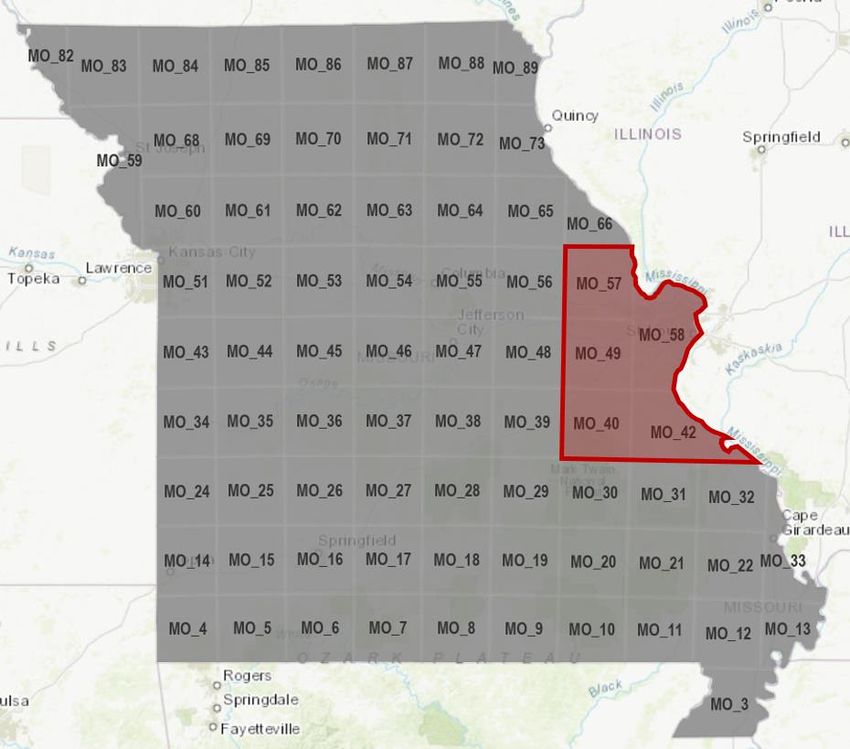
Foraging
In general, bumble bees forage on a diverse group of plants, though individual species
preferences in plants vary due to differences in tongue length. Some bumble bees have long
tongues and preferentially forage on plants with longer corolla tubes, such as penstemon,
where the nectar is located deep in the flower. Species with short tongues forage on flowers
with an open structure, such as sunflower and coneflower, because the bumble bees are able
to obtain nectar and pollen more easily.
Additionally, short-tongued bumble bees will engage in “nectar-robbing” from flowers with a
long corolla tube. Sitting on the outside of the flower, the bee will bite holes at the base of
the corolla tube and drink nectar by inserting her tongue. This practice is called nectar-
robbing because the bee does not touch the reproductive parts of the plant (male anthers or
female stigma) when accessing the nectar, thus taking the reward without contributing to the
plant’s pollination needs.
Flight Distance
Studies of flight distance show that different species of bumble bees vary in how far they
forage from the nest, with estimates ranging from 275 m (900 ft) to 750 m (2,460 ft—nearly
1/2 mi.), considerably further than most other native bees. Body size and colony size are
good predictors of flight distance of different species. There is also recent evidence that
bumble bee foraging distances decrease with nearby high-quality foraging habitat. This agrees
with optimal foraging theory, which suggests that bumble bees should seek to reduce their
flight distances; longer flights require more energy expenditure, and thus increased time
foraging for nectar, meaning fewer resources for offspring.
Temperature Regulation
Compared to many wild bees, bumble bees are large in size and covered in dense fur. They
also are able to thermoregulate, meaning they can control their body temperature by
generating or releasing heat. This ability to thermoregulate is uncommon among insects and
allows bumble bees to fly at colder temperatures than most other bees. As such, bumble bees
are able to thrive in northern temperate climates and high-elevation areas.
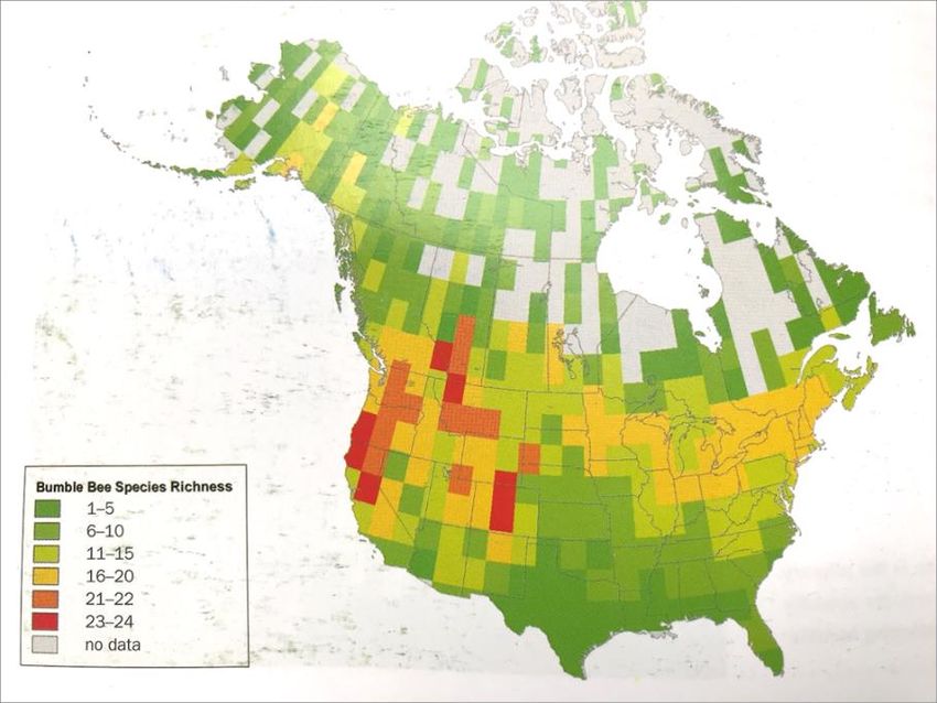
Species Diversity
Approximately 265 species of
bumble bees exist in the
world, and they are most
diverse in temperate regions.
In North America, species
diversity is highest in the
western mountainous and
coastal regions, with about 24
species. In Missouri, it is
expected there are about 13
different species. Bumble Bee
Species Richness
Illustration: An Identification
Guide to Bumble Bees of North
America, Williams et al. 2014
7|Page
Project Design
To design the Atlas, we first divided Missouri into 75 grid cells, the majority of which are 50
km by 50 km (31 mi by 31 mi), and developed a standardized protocol to keep sampling
efforts and data collection consistent. Next comes community scientists: The Atlas provides
volunteers with an active role in pollinator conservation by engaging them in bumble bee
survey efforts throughout Missouri.
As community scientists sign up to participate, each will “Adopt a Grid Cell.” Adopting a grid
cell means you agree to complete the minimum participation requirement for the Atlas by
conducting two bumble bee surveys in your selected grid. Surveys may be carried out during
Missouri’s peak bumble bee season, June-September. Further details are provided in How to
Participate below.
New Volunteers: We encourage you to adopt a grid cell that has not been adopted yet; these
cells are green on the website.
Returning Volunteers: You do not need to re-adopt your grid cell.
Visit MOBumbleBeeAtlas.org/adopt for a map of current grid adoption.

               The Atlas divides Missouri into 75 grid cells, which are then adopted and surveyed by project
               volunteers. Once a cell is adopted, it will turn yellow on the map. Adopt yours at
               mobumblebeeatlas.org/adopt.

If you cannot adopt a grid cell but still want to participate, we encourage you to download
the Bumble Bee Watch app (Apple or Android or website) and submit your observations.

8|Page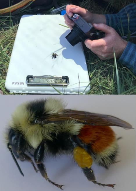
Tracking Your Efforts
Community scientists are the backbone of the Missouri Bumble Bee Atlas, so thank you for
participating! We are thrilled to have you on board, and would not be able to carry out this
important conservation work without your help. We are working hard behind the scenes to
make this project successful by providing you with the necessary resources, but we also want
to know all about your efforts: What does it really take to gather this information? What
amazing experiences do you encounter traveling throughout the state capturing and
identifying bumble bees?
We are aware you’re going to come across some amazing sights and experiences as you travel
throughout Missouri or explore closer to home. We’d love to hear your stories and see your
photos! As such, we invite you to share your experiences on Instagram, Facebook and Twitter.
We actively monitor these social media accounts to share interesting sightings or fun facts,
alert you about project events, and to highlight the experiences of project volunteers.

            Join the other Atlas volunteers in our Facebook group that is set up for people to
            interact, share photos or experiences, and ask questions.
            https://www.facebook.com/groups/mobumblebees

            Follow us on Instagram @mo_bumblebees to stay up to date with the project and
            use #MOBBAtlas to share your photos with us!
            https://www.instagram.com/mo_bumblebees/

Atlas Survey Blitz
A survey blitz will take place during the last Saturday of each survey month. These are
planned dates to target our efforts and see how much progress we can make together. Blitz
events are a joint effort between all Atlas projects, so there will be bumble bee watchers
surveying in Missouri, Minnesota, California, Oregon, Idaho and Washington! A fantastic
snapshot of bumble bees will be gathered as a result of participants surveying simultaneously
in 7 states. We encourage you to participate in one (or all!) of the blitz events, if possible.
2021 Atlas Blitz Dates:
       Saturday June 26, 2021
       Saturday July 24, 2021
       Saturday August 28, 2021
       Saturday September 25, 2021

9|Page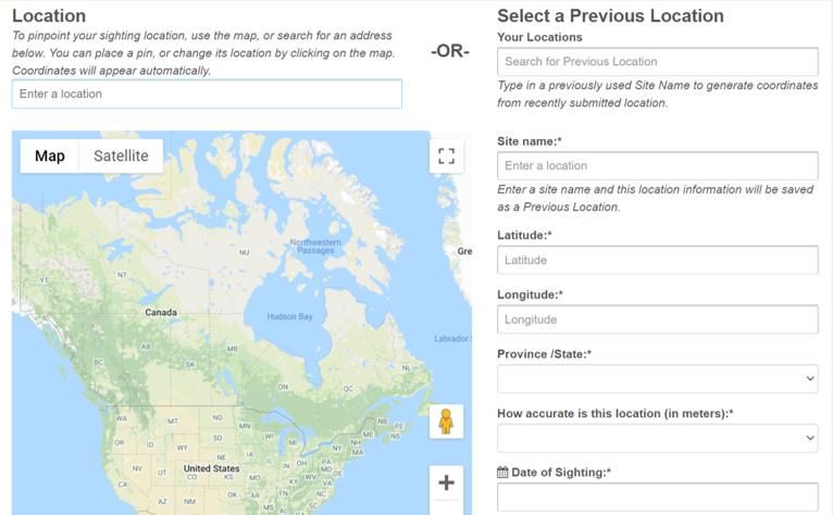
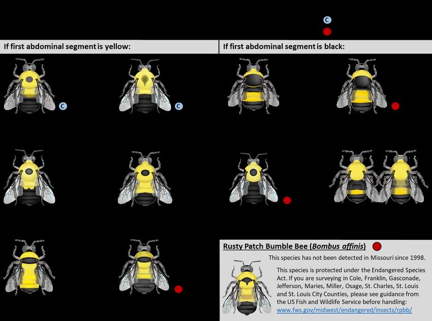
Endangered Species
The Rusty Patch Bumble Bee (Bombus affinis) is a federally protected bee under the U.S.
Endangered Species Act.

The U.S. Fish and Wildlife Service (USFWS) maintains an online map that identifies areas
where the Rusty Patch Bumble Bee is likely to be present. We have identified Atlas grid cells
(see red area below) that correlate with the UWFWS range map. While the highlighted areas
shown on the map are currently considered unoccupied, we urge to exercise caution when
surveying these particular grid cells and know how to recognize the Rusty Patch Bumble Bee
should you observe one. The USFWS does not recommend that folks obtain scientific recovery
[section 10(a)1(A)] permits to survey bumble bees in unoccupied areas.

In the unlikely event that you observe a Rusty Patch Bumble Bee, stop activity and notify
the USFWS MO Ecological Services Office: https://www.fws.gov/midwest/ColumbiaES/
Identification Guide: https://www.fws.gov/midwest/endangered/insects/rpbb/rpbbid.html

For additional information and recommendations visit the USFWS B. affinis map webpage.

          The grid cells highlighted in red (MO_40, MO_42, MO_49, MO_57 and MO_58) are within the historical
          range of the Rusty Patch Bumble Bee. While these areas are currently considered unoccupied, were
          urge to exercise caution when surveying these particular grid cells and know how to recognize the
          Rusty Patch Bumble Bee should you observe one.

10 | P a g e
How to Participate
Step 1: Register
The first thing you will need is a Bumble Bee Watch account. You can easily set up an account
online in about 5 minutes.
1. If you do not have a Bumble Bee
Watch account, please create an
account, and be sure to select
Missouri BBA as your project. This will
help us keep track of user
participation and data for the project.
2. If you already have a Bumble Bee
Watch account, all you need to do is
register your account with the Missouri
Bumble Bee Atlas project. To do this
simple step, start by logging in
(www.BumbleBeeWatch.org), click on
your username at the top right of the
page, and this will bring you to your
profile. In the left corner above your photo, click “edit”. Scroll towards the bottom to
the last drop-down box labeled as “Project” and select Missouri BBA, and then click
save. You are all set!
Step 2: Adopt a Grid Cell
After you have established a Bumble Bee Watch account, use the same email address to
“adopt a grid cell.” Adopting a grid cell (survey area) means that you have agreed to be an
integral part of this project, and plan on surveying your grid cell for bumble bees using our
standardized protocols. At a minimum, you will need to complete two surveys during peak
bumble bee season, June-September, to observe bumble bees and the surrounding habitat. To
meet this minimum requirement, you may visit two different locations within your grid cell on
the same day, or revisit the same location on two different days.
When choosing a grid cell to adopt, consider the travel involved, and keep local and federal
community health guidelines in mind. While our goal is to spread out and survey the entire
state, your health and safety is of top priority.
To adopt a grid cell, visit the Atlas website to use the interactive project map. This allows
you to see which grid cells are still available for adoption. Find the map and adoption
instructions at: https://www.mobumblebeeatlas.org/instructions.html.
New Volunteers: We encourage you to adopt a grid cell that has not been adopted
yet; these cells are green on the website.
11 | P a g eReturning Volunteers: You do not need to re-adopt your grid cell. If you cannot adopt a grid cell but still want to participate, we encourage you to use the Bumble Bee Watch app (Apple or Android) or website and submit your observations. Step 3: Get Familiar With Project Protocols The best way to become acquainted with project protocols is by attending a workshop or using our online materials. For 2021, these workshops will all be virtual; we may be offering in-person field days later in the season, stay tuned for announcements. Even though the training workshops are remote, all of our materials are designed to provide you with the knowledge, skills and confidence to conduct your own bumble bee surveys. You’ll learn about bumble bee biology, behavior, ecology, threats, conservation, and then dive into the identification of Missouri’s bumble bee species and how to conduct a survey and submit your data. Much of the information given in a workshop is included in this document, but attending a live event will allow you to connect with other Atlas community scientists and ask questions of project coordinators. Plus, it’s fun! We’ve had great feedback from volunteers who attended workshops for the Nebraska Bumble Bee Atlas and Pacific Northwest Bumble Bee Atlas. In addition to workshops, we may also host Field Days if conditions are safe to do so. Field Days are shorter than workshops, and provide Atlas participants, as well as those who are interested in the Atlas, a chance to work alongside one of our experts. This time may be used to run bumble bee surveys, photograph or identify bees, or practice any other skill requested by an attendee. For 2021 events, please visit: https://www.mobumblebeeatlas.org/events All of our materials are available through the Online Training Portal, including a series of video modules that will allow you to prepare remotely for the field season at your own pace. To start your training, visit: https://www.mobumblebeeatlas.org/train-online Step 4: Conduct a Survey Plan your visit Take some time to investigate your adopted grid cell. The grid cells are large with varied habitat, terrain and land ownership. You can survey anywhere in the grid cell for bumble bees, but planning your route to the survey location will increase your efficiency. Pay attention to local conditions and remain flexible. We suggest you start with the project map, or Google Maps (or similar) with aerial photography to flag potential sites and plan travel routes. Getting familiar with your sites using maps will also help you when it comes time to submit your data; accurate locations are important. Many areas in the state are rural, with limited travel routes and cellular service. When surveying, please follow all rules, regulations and posted signs; respect private property and take all necessary safety precautions. You can find interactive maps here: https://www.mobumblebeeatlas.org/resources. 12 | P a g e
It is possible that when you arrive at a pre-selected site, you’ll find that survey conditions for
bumble bees may not be optimal for a survey. For example, the wind may be too strong, rain
may have started, or the open field has been developed. We encourage folks to be flexible,
and opportunistic, but to stay within their assigned grid cell. As such, bring resources with
you to navigate, including printed maps, as cell service is not available in many parts of
Missouri.
For the purpose of planning your trip, we’ve provided a few resources to help. (Note: we do
not guarantee the veracity of any of these resources, we simply provide them as tools to help
plan your trip. To our knowledge, these are some of the best and most reliable mapping
resources available, though alternatives certainly exist.)
Google Maps with Overlaid Grid (you will be able to find the grid number of your
adopted cell to help you plan a trip).
Missouri Conservation Areas: https://nature.mdc.mo.gov/discover-nature/places
Missouri Hiking Trails: https://www.hikingproject.com/directory/8008930/missouri
USGS Topo Maps; available from many outdoor retailers and as downloads.
Considerations:
Ideally, you will survey in an open area with lots of flowers.
Consult with local knowledge about road surfaces and do not always rely on GPS or
Google/Apple Maps for travel planning. Many roads in rural areas of the state are
gravel and may be inaccessible during inclement weather. Additionally, these roads
may have limited shoulder space for parking, turning around, and require walking to
reach your destined grid cell.
Where to Survey:
Public land or public right-of-ways (roadsides)
Your own acreage, a friend or relative’s that you have explicit permission to survey
Missouri Dept. of Conservation Areas
o Complete Volunteer Agreement (end of handbook or access internet-version
pdf on the Atlas website) and return to the appropriate Area Manager
before surveying. Find Area Manager by visiting:
https://mdc.mo.gov/contact-engage/regional-offices
US Forest Service lands (like Mark Twain National Forest)– download Avenza Maps
app to access the Motor Vehicle Use Map (MVUM) to stay on legal roads, you are
free to walk anywhere. 4WD is needed for most USFS roads.
MRAP All Access Sites, mdc.mo.gov/mrap
Where to NOT Survey:
*You may not capture bumble bees in the following locations without a permit, please only
take photographs to submit as incidental observations if you visit one of these areas.
National Monuments
National Wildlife Refuges
Waterfowl Production Areas (WPAs)
13 | P a g eWhat to Bring:
Paper Maps Field guides (plant and bumble bee)
Camera (ideally with macro Timer
capacity) and/or smart phone GPS Unit or similar Smartphone App
Extra batteries and/or charger Hat
Insect net Drinking water
Data sheets and pencil/pen Sunscreen
Small cooler with crushed ice Field notebook
Vials or insect viewing jar Hand lens
Conduct Your Survey
The minimum participation requirement is for each grid adoptee to complete two formal
surveys anytime between June and September. A complete formal survey is made of two
components, which include (1) a bumble bee survey and (2) a habitat assessment. There are
two types of bumble bee surveys you may conduct within your grid cell to fulfill the minimum
participation requirement: point surveys and roadside surveys.
Point Surveys: Select an area that is 1 hectare in size, conduct one 45 person-minute
bumble bee survey and one habitat assessment.
Roadside Surveys: Drive or bike along a 10-mile stretch of road, stop at five points
along that stretch at least ½ mile apart. Conduct one 15 person-minute bumble bee
survey and one habitat assessment at each stop. You will have conducted 5 total
surveys at the end which will be submitted separately to Bumble Bee Watch.
You may complete the minimum requirement by conducting two point or two roadside
surveys, or a combination of the two. These surveys may be completed on the same day in
different areas or in the same area on different days. There is no maximum number of
surveys, welcome community scientists to complete as many formal surveys as they wish.
See Survey Methods for further details.
Step 5: Submit Your Data
All data will be submitted to the community science website: Bumble Bee Watch.
1. Keep track of the time you spend on this part, you will enter this as volunteer hours
into Bumble Bee Watch.
2. Curate your photos. Decide which photos you are going to upload for each bee entered
on your data sheet. Make sure they are clear and the lighting is good. You can submit
up to 5 photos per bee, so choose the clearest, best lit photos if you took more than
that. If you are unsure of the plant you caught the bee on and have a photo of that
plant, upload that plant as one of your 5 photos.
3. Login to Bumble Bee Watch.
4. Choose Record a Sighting —> Bumble Bee Sighting (from the gray options bar)
14 | P a g e5. Under Project select Missouri BBA. This must be selected in order to enter your habitat
data.
6. Enter your location information.
a. Above the map, search for the city nearest your survey area and then navigate
directly on the map to find the precise area. Once you click on your survey
area on the map, the latitude and longitude fields will automatically populate.
b. Give your survey area a Site Name of your choosing.
c. Enter the accuracy; meaning how close to your actual survey location is the
selected map point?
15 | P a g e7. Use your data sheet to enter details about the survey you conducted including the
survey type, collection method, number of observers, time, weather, and weather
notes.
8. Use your habitat data sheet to select the dominant habitat type of your survey area,
and the top three habitat types that surrounded your survey area. If a single habitat
type surrounded your survey area, you only need to complete the first dropdown menu
for surrounding area. Then select the percentage of flowering resources in your survey
area, and check the boxes of any habitat features that were in or near your survey
area.
9. Use the drop down menu to select Yes, No, or Suspect for each of the eight practices.
16 | P a g e10. Enter your blooming plants. Start by using the dropdown menu to select how many
different species were in bloom that were not visited by a bumble bee. The website
will automatically provide you with the appropriate amount of spaces to enter your
plant information (up to 15 plants).
11. Enter the total amount of time you spent on this effort. If you conducted multiple
surveys on the same day, please only enter this information on one of your
submissions.
12. Hit Next in the bottom right and you will be taken to Step 2 and see a green box
appear in the upper right stating your checklist has been saved. If you are not taken to
the next screen, scroll back up and look for any red text, chances are you forgot to
complete a required question.
17 | P a g e13. Step 2 is where you will begin entering your bumble bee photos and the flowers you
observed them on. You can upload up to 5 photos per bee, one of which can be the
flower you observed the bee on. A green box will appear confirming your uploads.
14. After uploading your photos and entering the floral host, click Identification Tool if
you need help figuring out which species you observed.
18 | P a g e15. As you select features that match your images, the identification tool will narrow
down the list of species you may have. When you click on a species, the tool will close
and you will be brought back automatically to the submission page. If you are not
confident in your identification after using the tool, you can leave the species
dropdown box as Sp. / Bumble Bee, experts will verify everything.
16. After selecting an identification for your bee, double check you have entered the
floral host and any notes. Then click Add Another in the bottom left if you have more
bees to enter from this survey. This will produce a subsequent section to upload
another bumble bee observation. Repeat this step until you have entered information
and photos for each of the bees you captured.
19 | P a g e17. After you have entered all of your bumble bee photos, click Save at the bottom. A
green box will appear in the top corner and a timestamp will be appear beneath the
Save button. If you see these two items, you may close the window.
18. Thank you! You will need to repeat this procedure for each individual survey.
Survey Methods
Survey Timing and Conditions
In Missouri, bumble bees are generally active from April through October depending on the
weather, location, and particular species. Some species may be active earlier, and some may
be active later. However, since the goal of the Atlas is to gain a better understanding of
bumble bee distribution statewide, we’re targeting peak active season of the bees when most
species are active. You may carry out bumble bee surveys any day from June through
September.
When planning your survey day, ensure that conditions are appropriate. Bumble bees prefer
to forage on calm sunny days when the temperature is between 60°F and 90°F, and winds aresummer, please keep an eye on the radar and know that bees will not be active in the rain, despite temperature. To summarize, you may survey on any day during June, July, August or September as long as the temperature is between 60°F and 90°F, winds are
plants that are flowering. Focus on ALL flowering forbs, not just those that are most abundant
or showy, because different bumble bees are sometimes attracted to different flowers.
Pro Tip: Pay attention to where your shadow falls on the flowers to avoid spooking the bee.
When you catch a bumble bee, pause your timer, transfer the bee into a vial (either directly
or using an insect net), note the plant species that it was visiting, and place the vial in a
chilled cooler. If you’re unsure of the plant, take a few photographs of its flower head, stem
and leaves for later identification. The smartphone app iNaturalist is a great identification
resource for wildflowers and has the capability to save photos and locations of all your
observations.
Pro Tip: Assign a number to each vial and write the same number on your data sheet to keep
each bee connected to its flowering plant. Alternatively, place a petal of the flower into each
vial to remind you which plant species that particular bee was visiting.
Continue in this fashion for 45 person-minutes (count only time searching for bumble bees) or
until you have run out of vials. If you run out of vials, stop the timer and continue to Phase 4.
Once Phase 4 is complete and your vials are free again, return to Phase 3 and finish out the
time remaining on your survey. When finished, note the end time of your survey.
Phase 4: Photo Document Each Bumble Bee
                                 When your 45 minute timer is up, the chilled bees will be
                                 slow enough that you can easily photograph them. If the
                                 bee is still moving too much, leave the vial on ice for 5-
                                 10 more minutes.
                                         To photograph the bee, start by placing it on a flat
                                         surface with high contrast, such as the back of a data
                                         sheet, on a clipboard or cooler lid (see photo at left). To
                                         take clear, in-focus photographs of each bee we
                                         recommend using a camera with a macro lens setting
                                         (look for a flower icon) or a smartphone, see the supplies
                                         list for more on cameras. See the back of the Nebraska
                                         Bumble Bee Atlas Identification Guide for a checklist of
                                         features that need to be shown in your photographs.
                                                 A maximum of 5 photos per bee may be uploaded when
                                                 you submit your data online. Be sure to document how
                                                 many photos you take of each bee, and note the file
Images: J. Metcalf; Katie Lamke / Xerces Society names on the data sheet. After logging this information,
your bumble bee data sheet should have a row containing the bee name, plant name, and
associated photographs for each collected bee. See a data sheet example in Data Sheets and
Field Guides.
If the bumble bee is sluggish after you photograph it, just place it in the shade and it will
take flight after warming up. Continue in this fashion until you have documented each
individual bumble bee. If you have time remaining on your survey, return to Phase 3,
otherwise continue to Phase 5.

22 | P a g e
Pro Tips for Photographing Bees: mobumblebeeatlas.org/phototips Phase 5: Habitat Assessment After photo documenting your bumble bees, or while they chill longer on ice, spend a few minutes filling out the Habitat Assessment Form. This form provides us with a snapshot of the present habitat, and an idea of food and nesting resources available to bees in your survey area. Detailed instructions for completing this form being on page 24. Phase 6: Check for Completeness While still at your survey area, double check your data sheets to ensure that they are complete. It may be tempting to leave some of this information for later, or to finish when you get home, but taking the time to do it while on site will reduce errors and increase the quality of the data you collect. Phase 7: Submit Your Data After completing your formal survey, please try to submit your data as soon as possible. To submit data, log on to MOBumbleBeeAtlas.org, navigate to the Data tab and click Submit Data. See pages 14-20 for detailed information, or visit the following webpage for guidance: https://www.mobumblebeeatlas.org/data-help Roadside Surveys Roadside surveys are the second type of formal survey, and are great for documenting different types of bumble bees and in different types of habitats. Roadside surveys take place along a 10-mile stretch of road or trail within your grid cell, and may be completed by car or bike. One complete roadside survey is made up of five 15-minute bumble bee surveys and five habitat surveys. You essentially complete 5 mini points surveys that are at least ½ mile apart along your selected 10-mile stretch. Often times, these 15-minute surveys allow for easy participation because roadsides are readily accessible, do not require walking long distances or across uneven terrain. However, roadside surveys come with added pitfalls because each individual survey is significantly shorter than a point survey, and our roadsides tend to play host many nonnative plants. Given that one of our project goals is to better understand Missouri’s Species of Greatest Conservation Need bumble bees, finding which native plants they are using is a priority. As such, roadside surveys may not be the best method to observe plant preference, but will still contribute to our understanding of bumble bee distribution and habitat needs. Roadside surveys may be conducted when traveling to or from a point survey site, or on their own, but should take place within your adopted grid cell. Please be sure to respect private property, follow posted signs and regulations, and obtain permits or permission if necessary. Safety vests or bright colors are highly recommended for roadside surveys. Phase 1: Plan Your Route Within your adopted grid cell, select a stretch of road or trail that is at least 10 miles long. Ideally, the stretch will have several obvious open patches when looking at aerial photos or maps. To find a route, we suggest using the Google Map that displays the Atlas grids. This way you can save locations, create start and end points, and get directions. The map link can be found at: https://www.mobumblebeeatlas.org/resources.html. 23 | P a g e
If you are surveying on US Forest Service property (see page 13), download Avenza Maps apps
to access the Motor Vehicle Use Map (MVUM). This map will show you which roads are open to
the public. Avenza Maps app: https://www.avenzamaps.com/maps/how-it-works.html
Plan to wear bright colors or a safety vest during your survey.
Phase 2: Begin Bumble Bee Survey
At the start of your selected route, pull over at the first patch of available flowers that you
observe. Please park carefully, follow local regulations and be aware of any safety
precautions. Before filling out the bumble bee data sheet, simply start by watching the flower
patch—if you observe bee activity, begin the survey. If there is no bee activity, proceed to
the next patch of flowers and repeat.
Before starting your timer, fill out the top of the bumble bee data sheet (name, date,
location, time, weather, etc…) and then start your 15-minute timer. While looking for bumble
bees, you should wander from flower patch to flower patch along the roadside area. Focus on
ALL flowering plants, not just those that are most abundant or showy, because different
bumble bees are sometimes attracted to different flowers.
Pro Tip: Pay attention to where your shadow falls on the flowers to avoid spooking the bee.
When you catch a bumble bee, pause your timer, transfer the bee into a vial (either directly
or using an insect net), note the plant species that it was visiting, and place the vial in a
chilled cooler. If you’re unsure of the plant, take a few photographs of its flower head, stem
and leaves for later identification. The smartphone app iNaturalist is a great identification
resource for wildflowers and has the capability to save photos and locations of all your
observations.
Pro Tip: Assign a number to each vial and write the same number on your data sheet to keep
each bee connected to its flowering plant. Alternatively, place a petal of the flower into each
vial to remind you which plant species that particular bee was visiting.
Phase 3: Photo Document Each Bumble Bee
After the first 15-minute survey, photograph and release all the chilled bees you collected at
that site before moving to the next survey. If the bee is still moving too much, leave the vial
on ice for 5-10 more minutes while you fill out the Habitat Assessment form for that site.
Please follow Phase 4 of the Point Survey for instructions on how to photo document your
bees.
Phase 4: Habitat Assessment
After photo documenting your bumble bees, fill out a Habitat Assessment form for each
roadside stop. Detailed instructions for this step begin below.
Phase 5: Check for Completeness
While still at your survey area, double check both of your data sheets to ensure that they are
complete. Make sure you know which bumble bee survey data sheet is associated with which
habitat assessment form. It may be tempting to leave some of this information for later, or to
finish when you get home, but taking the time to do it while on site will reduce errors and
increase the quality of the data you collect.

24 | P a g e
Phase 6: Repeat
Drive or bike at least ½ mile down the road, find another patch of flowering plants, and
conduct another survey starting at Phase 2 (see page 21). The roadside survey is complete
when you have surveyed 5 different locations along your 10-mile route. You will have 5
bumble bee survey data sheets and 5 habitat assessment forms, one pair from each stop.
Phase 7: Submit Your Data
After completing your formal survey, please try to submit your data as soon as possible. To
submit data, log on to MissouriBumbleBeeAtlas.org, navigate to the Data tab and click Submit
Data. See pages 14-20 for detailed information or visit the following webpage for guidance:
https://www.mobumblebeeatlas.org/datahelp

Habitat Assessments
At each location that you conduct a bumble bee survey (Point or Roadside) you will need to
fill out a Habitat Assessment form. This information will help us to understand what
landscape features are important for bumble bees. The habitat survey should take between 5
and 15 minutes to complete.
Phase 1: Fill Out Site and Weather Information
Fill out the top of the form so it matches the information you recorded on the bumble bee
survey data sheet. If you are doing a point survey, you only need to complete one habitat
assessment. If you are doing a roadside survey, you need to conduct one habitat assessment
at each of your five stops.
Phase 2: Fill Out Habitat Information
   1. Check one primary habitat type to represent the survey area from the list provided.

   2. Select the top three most dominant habitat types representing the surrounding area
      (surrounding area refers to habitat just beyond the direct survey area, must be within
      sight distance). If there is only one surrounding habitat type, leave the following two
      options blank.

   3. Walk your entire survey
      area and then circle the
      estimated percentage of
      available flowering
      resources. See percent
      bloom examples in images
      to the right.
                                   Images depict survey areas with estimates of percent bloom at low
                                   end: 0-10% (left), and high end: 90-100% (right).
                                   Images: J. Meissen (left); Anne Stine / Xerces Society (right)

   4. Scan the area for bunch grasses, rodent holes, rock piles, and the other items listed on
      the data sheet and check off all that you see. These are landscape features associated
      with bumble bee nests.

25 | P a g e
5. Do your best to assess the management activities occurring in or near the survey area.
Take on a “What do you see right now?” approach. Can you tell if there was a fire
recently? Is the ground coated in ash and free of leaf litter? Is there a pasture
neighboring your survey area or presence of deer in your survey area? If you are near a
large agriculture field you might suspect herbicide or insecticide applications have
occurred recently or soon will. Again, these are general assessments attempting to
gain a snapshot of the landscape features in or near your survey area.
Phase 3: Document Blooming Plant Species
Flip the page over and do your best to fill in the names of blooming plant species in your
survey area. You may write down the common name or the scientific name, but try to be as
specific as possible – especially for those plants on which you found a bumble bee visiting. For
help with identifying plants, try using the smartphone app iNaturalist, or take photos to
identify later at home. If you take photos for later identification of the plant, use the far
right column to record the image file name assigned by your camera. This will help you
connect which photo goes with which row on your data sheet later on. If you observed a
bumble bee on a particular plant, check the box in far left column.
Phase 4: Submit Your Data
After completing your bumble bee and habitat assessment surveys, please try to submit your
data as soon as possible. To submit data, log on to MoBumbleBeeAtlas.org, navigate to the
Data tab and click Submit Data. See pages 14-20 for detailed information or visit the
following webpage for guidance: https://www.mobumblebeeatlas.org/datahelp
Alternative Survey Options
Incidental Observations
Now that you’ve caught the bug, observing bumble bees will occur naturally, whether you’re
walking your dog or passing a flower patch on your lunch break. This is great data too!
Unlike formal surveys, incidental observations do not follow protocol or have data sheets. To
complete an incidental observation, simply snap a photo of a bumble bee and submit it with
the time, date, and location. Incidental observations can occur anywhere, anytime; meaning
they do not have to be within your grid cell, and they do not have to be between June-
September.
What’s the point if we aren’t collecting strict bumble bee and habitat data? Well, incidental
observations help us fill in knowledge gaps throughout the state. For example, bees are active
from about April to October, so submissions from those tail ends of the season help us
understand when queens emerge in the spring, and how late they forage in the fall. These
simple observations also open up more areas to sample, such as National Parks where
collecting bees is restricted but photographing is allowed.
These observations will not take the place of formal surveys, and do not count towards
the minimum participation requirement. Likewise, there are no data sheets involved or
protocol to follow, but they will help fill in knowledge gaps throughout the state.
26 | P a g eFor an incidental observation to count towards the Atlas, it must include 1-3 photographs.
Submitting incidental observations is easy when using the Bumble Bee Watch app, which
allows you to photograph the bee and will automatically record a time/date/location stamp
on your submission. Alternatively, you may photograph the bee, later upload 1-3 photos to
Bumble Bee Watch from your computer, and manually enter the time/date/location.
You may photograph a bee directly on a flower or by using the protocol described in the
formal surveys. Only submit in-focus photographs that provide enough detail for
identification. Including information or photographs of the associated plant is also useful.
Considerations
Use Bumble Bee Watch app to submit bumble bee sightings.
Use iNaturalist app for assistance with identifying flowering plants.
Use ID Weeds to help determine weedy plant species.
Submit only the best, clear photos; if your photos are of different bee species, submit
them as different observations. We will double check all submitted identifications.
Submit observations of the same bee species visiting different flower species.
Do your best to identify the species of flower that the bumble bee was visiting.
Follow the same rules about location, private property, and general respect for others
experience when collecting incidental observations.
27 | P a g eSupplies The following is a list of recommended supplies that
will help you run bumble bee surveys efficiently.
Insect Net
BioQuip: https://www.bioquip.com/search/DispProduct.asp?pid=7112NA
Home Science Tools: https://www.homesciencetools.com/product/standard-insect-
net/?gclid=EAIaIQobChMI57vP9umF5AIVFYTICh3hmAygEAQYASABEgIKPfD_BwE
Search words for Amazon: “Aerial Insect Net”
Collection Vials
We like to use 50ml plastic vials, because they are lightweight, small, and chill
relatively quickly, making them ideal for survey trips. However, many items that are
easily found around the house can work for this purpose, such as empty jars or
containers; just make sure they are thoroughly washed.
Search words for Amazon: “30mL centrifuge tubes” or larger: “50mL centrifuge tubes”
Camera
The best type of camera for surveys are digital cameras that have a macro setting. We
like to use the Olympic TG-6 mainly because it has an amazing macro setting, GPS
capabilities, and has immense durability for use in the field. Smartphones work well if
your camera remains focused as you zoom, and if desired, you can easily enhance your
smartphone photos by purchasing a macro lens attachment. These lens attachments
are relatively low cost, just be sure the lens fits your phone model.
Ice Chest
Smaller 7-9quart coolers work best, as they’re more portable
Crushed Ice
Crushed ice seems to chill bees faster than larger ice blocks or gel cold packs because
vials can be fully submerged.
Clipboard
Helpful for filling out data sheets while in the field; can also be used as a surface to
photograph bees on.
GPS Device
Smartphone, “drop a pin” in your Map app to retrieve location coordinates in Decimal
Degrees. If recorded in an alternative format you can easily convert them online.
Pencils
Stopwatch/Timer
Weather Device
28 | P a g eResources Bumble Bee Identification Guides Bumble Bees of North America: An Identification Guide (2014) by Williams, Thorp, Richardson and Colla; Princeton University Press Book: https://press.princeton.edu/books/paperback/9780691152226/bumble-bees-of-north-america Bumble Bees of the Eastern United States (2012) by Colla, Richardson and Williams; USDA Forest Service and Pollinator Partnership PDF: https://www.fs.fed.us/wildflowers/pollinators/documents/BumbleBeeGuideEast2011.pdf Rusty Patch Bumble Bee Identification U.S. Fish & Wildlife Service Online: https://www.fws.gov/midwest/endangered/insects/rpbb/rpbbid.html Plant Identification Guides Missouri Wildflowers (2008) by Denison; Missouri Department of Conservation Book: http://www.mdcnatureshop.com/product.php?productid=277 Shrubs and Woody Vines of Missouri (2009) By Kurz; Missouri Department of Conservation Book: http://www.mdcnatureshop.com/product.php?productid=348 Missouri Wildflowers and Grasses Online: https://nature.mdc.mo.gov/discover-nature/field- guide/search?f[0]=field_fg_types:5592 Survey Planning Missouri Bumble Bee Atlas: Google Map of Grid Cells (2020) by Missouri Bumble Bee Atlas Online: https://tinyurl.com/y55ucg66 Missouri Conservation Areas (2021) by Missouri Department of Conservation Online: https://nature.mdc.mo.gov/discover-nature/places Missouri Hiking Trails System (2021) by Nebraska Game and Parks Commission Online: https://www.hikingproject.com/directory/8008930/missouri Missouri Road Conditions (2021) by Missouri Department of Transportation Online: http://traveler.modot.org/map/index.html 29 | P a g e
Further Reading
Bumblebees: Behaviour, Ecology, and Conservation (2009)
by Goulson; Oxford University Press
Book: https://global.oup.com/academic/product/bumblebees-9780199553075?cc=us&lang=en&

Conserving Bumble Bees: Guidelines for Creating and Managing Habitat for America’s
Declining Pollinators (2012)
by Hatfield, Jepsen, Mader, Black and Shepherd; Xerces Society
PDF: https://xerces.org/sites/default/files/2018-05/12-028_01_XercesSoc_Conserving-Bumble-Bees-
Guidelines_web.pdf (hard copy included when you attend a workshop)

The Solitary Bees: Biology, Evolution, Conservation (2019)
by Danforth, Minckley, Neff and Fawcett; Princeton University Press
Book: https://press.princeton.edu/books/hardcover/9780691168982/the-solitary-bees

The Very Handy Manual: How to Catch and Identify Bees and Manage a Collection (2015)
by Droege; USGS
PDF: https://bee-health.extension.org/wp-content/uploads/2019/08/TheVeryHandyBeeManual.pdf

Other Online Resources
Bug Guide: www.bugguide.net
An online resource devoted to North American insects, spiders and their kin, offering
identification, images, and information.
Discover Life: https://www.discoverlife.org/
An interactive encyclopedia about the taxonomy, natural history, distribution, abundance &
ecology of species.
USDA Plants Database: https://plants.sc.egov.usda.gov/java/
Provides standardized information about plants, including ranges, native status and scientific
names for species in the U.S. and its territories.
USGS Pollinator Library: https://www.npwrc.usgs.gov/pollinator/home
An online database of plant-pollinator interactions, searchable by plant, pollinator, location.
Xerces Society for Invertebrate Conservation: https://xerces.org/publications
Publications and resources produced by Xerces Society.

Project Websites
Missouri Bumble Bee Atlas: https://www.mobumblebeeatlas.org/
Xerces Society for Invertebrate Conservation: https://xerces.org/
Missouri Department of Conservation: https://mdc.mo.gov/
University of Missouri: https://cafnr.missouri.edu/
Pheasants Forever and Quail Forever: https://missouripfqf.org/

30 | P a g e
Data Sheets and Field Guides

31 | P a g e
MISSOURI BUMBLE BEE ATLAS – HABITAT ASSESSMENT FORM
Complete this form for every site that is surveyed            Date Data Entered:___________________By:_____________________________

Site and Weather Information
 Site Name:                       Date:                            Grid ID:                                                            Temp (F):
 Latitude (DD):                   Start Time:                      Survey Type:      Point                Roadside (Survey __/5)       Wind (mph):
 Longitude (DD):                  End Time:                        Num. of Surveyors:                                                  Cloud Cover (%):
 Survey Minutes (# minutes x # surveyors):                                          Point = 45 total minutes; Roadside = 15 min/stop   Weather Notes:
 Collection Method (circle one): Capture and Photo: all observed bees Capture and Photo: only bees that look different    Photo only

Bumble Bee Observations
  Entered
  in BBW
                        Bumble Bee Species                       Host Plant                                Photo Numbers                                  Notes

    □
    □
    □
    □
    □
    □
    □
    □
    □
    □
    □
32 | P a g e
MISSOURI BUMBLE BEE ATLAS – HABITAT ASSESSMENT FORM
Complete this form for every site that is surveyed Date Data Entered:___________________By:_____________________________
Entered
in BBW
Bumble Bee Species Host Plant Photo Numbers Notes
□
□
□
□
□
□
□
□
□
□
□
□
□
□
□
33 | P a g eMISSOURI BUMBLE BEE ATLAS – HABITAT ASSESSMENT FORM
Complete this form for every site that is surveyed Date Data Entered:___________________By:_____________________________
Site and Weather Information
Site Name: Pete’s ranch Date: 6/15/21 Grid ID: MO_37 Temp (F): 68
Latitude (DD): 41.3365 Start Time: 10:20 am Survey Type: Point Roadside (Survey __/5) Wind (mph): 10
Longitude (DD): - 96.1476 End Time: 10:35 Num. of Surveyors: 3 Cloud Cover (%): 25
Survey Minutes (# minutes x # surveyors): 45 Point = 45 total minutes; Roadside = 15 min/stop Weather Notes:
Collection Method (circle one): Capture and Photo: all observed bees Capture and Photo: only bees that look different Photo only
Bumble Bee Observations EXAMPLE
Entered
in BBW
Bumble Bee Species Host Plant Photo Numbers Notes
□ Brown-belted bumble bee Asclepias syriaca IMG_77, IMG_78, IMG_79, IMG_80, IMG_81
□ Brown-belted bumble bee Sweetclover IMG_82, IMG_83, IMG_84, IMG_85
Brown-belted or two-
□ Unknown Sweetclover IMG_86, IMG_87, IMG_88, IMG_89, IMG_90
spotted?
Plant photo #s on
□ American bumble bee Unknown (took photos) IMG_91, IMG_92, IMG_93, IMG_94, IMG_95
habitat sheet
□ Black and Gold bumble bee Field Thistle IMG_101, IMG_102, IMG_103, IMG_104
□
□
□
□
□
□
34 | P a g eMISSOURI BUMBLE BEE ATLAS – HABITAT ASSESSMENT FORM
Complete this form once for each point survey or five times for each roadside survey (one per stop)
Site Information
Enter the same information from your associated bumble bee survey data sheet.
Site Name: Date: Survey Type: Point Roadside (Survey __/5)
Habitat Information
Habitat Type (Select One) Example
SURVEY AREA Agricultural Land Cropland, Pastureland, Orchard, etc.
Check ONE category Developed/Roadside Urban/Suburban; Manicured Park; Garden
that represents the Grassland Grasses make up dominant vegetation; Natural area
dominant habitat type
Riparian Along a stream or creek
If you are doing a roadside
survey, please remain easily
Shrub/Steppe Arid land; Low-rainfall grassland
visible to vehicles. Wetland Bogs, Marshes, Swamps, etc.; Saturated land
Woodland Trees make up dominant vegetation
st
SURROUNDING AREA 1 Most Abundant (Select One) 2nd Most Abundant (Select One) 3rd Most Abundant (Select One)
Select the top three Agricultural Land Agricultural Land Agricultural Land
most abundant habitat Developed/Roadside Developed/Roadside Developed/Roadside
types that are directly
outside of your survey Grassland Grassland Grassland
area within sight Riparian Riparian Riparian
distance. Shrub/Steppe Shrub/Steppe Shrub/Steppe
If there is only one surrounding
habitat type, leave 2nd and 3rd
Wetland Wetland Wetland
categories blank. Woodland Woodland Woodland
How much of the survey area has flowering resources available? (Circle one)
0% 10% 20% 30% 40% 50% 60% 70% 80% >90%
Which of the following features do you see in or near the survey area? (Check all that apply)
Bunch Grasses Rodent Holes or Tunnels Brush Piles Loose, Bare Soil
Leaf Litter Pine Needle Duff Rock Piles Mulch None of the Above
I see evidence of, or know that the following have occurred in or near the survey area this season:
Circle Yes, No, or Suspect for each category
Mowing Yes No Suspect
Livestock Grazing (Do you see animals, cow pies, hoof prints, etc.) Yes No Suspect
Native Grazing (Do you see animals, scat, hoof prints, etc.) Yes No Suspect
Agriculture Yes No Suspect
Insecticide use Yes No Suspect
Herbicide use Yes No Suspect
Fire (Controlled or Wild) Yes No Suspect
Honey Bee Hives (Num. of Hive Boxes Seen:_______ ) Yes No Suspect
Management Notes:
35 | P a g eYou can also read