European primary forest database v2.0 - assets.panda.org
←
→
Page content transcription
If your browser does not render page correctly, please read the page content below
www.nature.com/scientificdata

               OPEN           European primary forest database
Data Descriptor               v2.0
                              Francesco Maria Sabatini et al.#

                              Primary forests, defined here as forests where the signs of human impacts, if any, are
                              strongly blurred due to decades without forest management, are scarce in Europe and
                              continue to disappear. Despite these losses, we know little about where these forests
                              occur. Here, we present a comprehensive geodatabase and map of Europe’s known primary
                              forests. Our geodatabase harmonizes 48 different, mostly field-based datasets of primary
                              forests, and contains 18,411 individual patches (41.1 Mha) spread across 33 countries. When
                              available, we provide information on each patch (name, location, naturalness, extent and
                              dominant tree species) and the surrounding landscape (biogeographical regions, protection
                              status, potential natural vegetation, current forest extent). Using Landsat satellite-image
                              time series (1985–2018) we checked each patch for possible disturbance events since primary
                              forests were identified, resulting in 94% of patches free of significant disturbances in the
                              last 30 years. Although knowledge gaps remain, ours is the most comprehensive dataset on
                              primary forests in Europe, and will be useful for ecological studies, and conservation planning
                              to safeguard these unique forests.

                              Background & Summary
                              The importance of primary forests is widely recognized1,2. First, they provide refuge to forest biodiversity3, and
                              act as a buffer to species loss in human-dominated landscapes4. Second, primary forests play an important role in
                              climate change mitigation. At the local scale, they buffer the adverse effects of increasing temperature on under-
                              story biodiversity, as they often have cooler forest-floor summer temperatures compared to secondary forests5. At
                              the global scale they contribute to climate stability by storing large quantities of carbon, both in the biomass and
                              in soils1,6,7. Third, primary forests often serve as a reference for developing close-to-nature forest management, or
                              for benchmarking restoration efforts8. Finally, these forests are an irreplaceable part of our natural heritage, shape
                              the cultural identities of local communities, and have a high intrinsic value9.
                                  In Europe, as in many human-dominated regions, most forests are currently managed10, often with increasing
                              harvest intensities11,12. As a result, despite the general trend of increasing total forest area, primary forests are
                              scarce and continue to disappear13. For instance, Romania hosts some of the largest swaths of primary forest in
                              Central Europe and faced a sharp increase in logging rates since 2000. This has resulted in significant primary
                              forest loss, even within protected areas13–15. In Poland, the iconic Białowieża Forest was recently in the spotlight
                              after the controversial decision from the Polish National Forest Holding, now nullified by the Court of Justice
                              of the European Union16, to implement salvage logging followed by tree planting after a bark beetle outbreak17.
                              Widespread loss of primary forests also occurred in Ukraine18, Slovakia19, or in the boreal North, e.g., in the
                              Russian North-West, where 4.6 Mha of primary forest were lost since 200113,20. Effective protection of Europe’s
                              primary forests is therefore urgently needed21.
                                  In the newly released ‘Biodiversity Strategy for 2030’, the European Commission emphasized the need to
                              define, map, monitor and strictly protect all of the EU’s remaining primary forests2. Reaching these objectives
                              requires complete and up-to-date data on primary forests’ location and protection status. Such data could inform
                              both policy making and conservation planning, as well as research, for instance by highlighting areas where
                              primary forests are either scarce, or poorly studied. Yet, many data gaps remain on the location and conservation
                              status of EU’s primary forests21,22. Only a few countries conducted systematic, on-the-ground inventories19,23. For
                              most countries data are either only available for a few well-studied forests24–26, or are limited to the distribution of
                              potential (=unconfirmed) primary forests, typically predicted statistically or via remote sensing27–29. Despite past

                              #
                                A full list of authors and their affiliations appears at the end of the paper.

  Scientific Data |   (2021) 8:220 | https://doi.org/10.1038/s41597-021-00988-7                                                                     1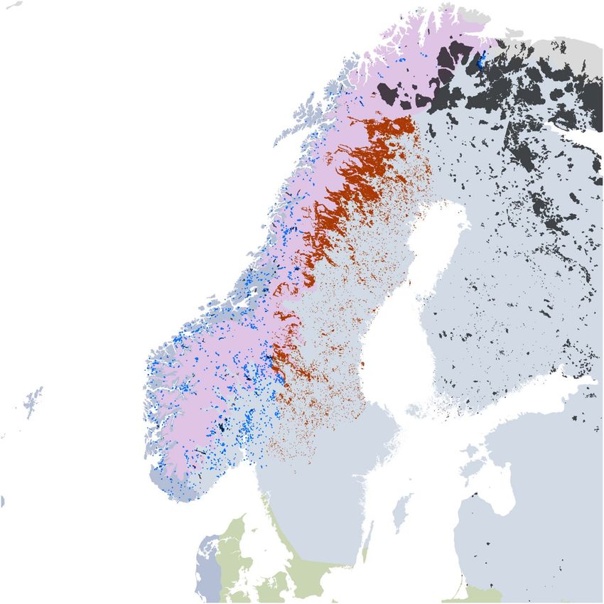
www.nature.com/scientificdata/                                                                      www.nature.com/scientificdata

                            Fig. 1 Overview of the primary forest patches contained in the EPFD v2.0. Both points and polygons were
                            magnified to improve visibility.

                            efforts for harmonizing data24,30, only recently has the first map of primary forests been released for Europe31,32
                            together with a first assessment of their conservation status21.
                                In a previous effort, we assembled a first European Primary Forest database (EPFD v1.0) that included 32
                            local-to-national datasets, plus data from a literature review and a survey, resulting in the mapping of a total
                            of ~1.4 Mha of primary forest31. This was only about one fifth of the estimated 7.3 Mha of undisturbed for-
                            est still occurring in Europe, excluding Russia10. Also, most of the data collected in our v1.0 database were not
                            open-access, and could thus not be used without the explicit consent of their respective copyright holders.
                                Here, we build on those efforts to progress further towards a complete map of Europe’s primary forests. First,
                            we secured permission from all data holders to release all data with open-access. Second, we aggregated and har-
                            monized 16 additional regional-to-continental spatial datasets to now cover a total of 48 independent datasets.
                            The EPDF v2.0 contains 18,411 non-overlapping primary forest patches (plus 299 point features) covering an area
                            of 41.1 Mha (37.4 Mha in European Russia alone; Fig. 1) across 33 countries (Table 1)33. Key improvements of
                            this new database include (a) filling major regional gaps, including European Russia, the Balkan Peninsula, the
                            Pyrenees and the Baltic region, (2) mapping potential primary forests for Sweden and Norway (additional 16,311
                            polygons and 2.5 Mha - Fig. 2), two key regions where complete inventories are currently unavailable, and (3) an
                            update of our literature review to January 2019.

                            Methods
                            Primary forest definition. Defining primary forests is controversial, and a range of different definitions
                            have been put forward over the years22. In this paper, as in our previous work, we follow the FAO definition that
                            defines primary forests34 as “naturally regenerated forest of native tree species, where there are no clearly visible
                            indications of human activities and the ecological processes are not significantly disturbed”.
                                We operationalized this definition using the framework proposed by Buchwald35, where ‘primary forest’ is
                            used as an umbrella term to include forests with different levels of naturalness, such as primeval, virgin, near‐vir-
                            gin, old‐growth and long‐untouched forests. Based on this framework, a forest qualifies as primary if the signs
                            of former human impacts, if any, are strongly blurred due to decades (at least 60–80 years) after the end of forest
                            management35. This time limit, however, depends on how modified the forest was at the starting point, and only
                            applies in the case of traditional management, such as patch felling, partial coppicing, or selective logging. Stands
                            regenerating naturally after a clear cut would therefore require a longer time period to be considered a primary
                            forest (i.e., 60–80 years plus the length of a typical rotation cycle). Our definition of primary forests, therefore,
                            does not imply that these forests were never cleared or disturbed by humans. We consider this is in line with the
                            Convention of Biological Diversity (CBD, https://www.cbd.int/forest/definitions.shtml), acknowledging that the
                            concept of primary forests has a different connotation in Europe than in the rest of the world.
                                Finally, our collection of primary forests includes mainly old-growth, late-successional forests, but also some
                            early seral stages and young forests that originated after natural disturbances and natural regeneration, without
                            subsequent management. In case of large primary forest tracts (>250 ha), our polygons can also locally include
                            land not covered by trees.

                            Data collection.      To create the EPFD v2.0, we first expanded and updated the literature review on primary
                            forests we had originally carried out for EPFD v1.031, which only considered the period 2000–2017, and excluded

Scientific Data |   (2021) 8:220 | https://doi.org/10.1038/s41597-021-00988-7                                                                  2
www.nature.com/scientificdata/                                                                              www.nature.com/scientificdata

                             Country                  Num. features (Polygons\ Points)   Tot. estimated area (1,000 ha)   Sources (Dataset IDs)
                             Albania                  13\6                               13.36                            0, 1, 47, 54
                             Austria                  34\2                               1.46                             9, 35, 49
                             Belarus                  3\0                                188.29                           46
                             Bosnia and Herzegovina   4\12                               4.1                              0, 2, 50, 53
                             Bulgaria                 483\2                              56.77                            0, 3, 4, 35
                             Croatia                  45\3                               6.24                             0, 5, 9
                             Czechia                  86\10                              9.07*                            0, 6, 9
                             Denmark                  0\24                               1.68                             7
                             Estonia                  0\29                               0.05*                            0, 8
                             Finland                  1,008\3                            2,817.36*                        0, 12, 38, 39
                             France                   106\7                              10.86*                           0, 13, 14, 35, 37
                             Germany                  25\21                              13.65*                           0, 9, 15, 35
                             Greece                   5\2                                1.75*                            0, 16
                             Italy                    86\12                              6.84*                            0, 18, 35, 55
                             Latvia                   3\0                                4.79                             40
                             Lithuania                20\0                               32.05                            19
                             Moldova                  0\1                                0.03                             35
                             Montenegro               2\0                                2.85                             2, 50
                             Netherlands              3\0                                0.08                             36
                             North Macedonia          5\1                                0.81                             1, 20
                             Norway                   240\1                              280.05*                          0, 21, 36, 43
                             Poland                   66\5                               21.15*                           0, 22, 35
                             Portugal                 32\21                              15.75*                           23, 24
                             Romania                  3,571\6                            59.11*                           0, 1, 25, 32, 33, 35
                             Russian Federation       3,082\3                            37,417.69*                       0, 51
                             Serbia                   14\4                               7.78                             0, 35, 36, 44, 45
                             Slovakia                 290\4                              10.98                            0, 9, 26
                             Slovenia                 170\1                              9.53                             0, 27
                             Spain                    44\58                              9.4*                             0, 41, 52
                             Sweden                   0\51                               32.81*                           0, 29, 35
                             Switzerland              5\5                                2.29                             0, 30, 35
                             Ukraine                  8,966\3                            97.8*                            0, 1, 32
                             United Kingdom           0\2                                0.1                              9
                             Total                    18,411\299                         41,136.53*

                            Table 1. Summary of primary forest data across European countries. Dataset IDs correspond to those in
                            Online-only Table 1. * Some point features have no information on forest patch area.

                            European Russia. Specifically, we added all scientific studies published between January 2000 and January 2019
                            for Russia, and those published in 2017–2019 for the rest of Europe. We identified relevant publications in the ISI
                            Web of Knowledge using the search terms “(primary OR virgin OR old‐growth OR primeval OR intact) AND for-
                            est*” in the title field. Based on our own interpretation of commonly used forest terms, we deliberately excluded
                            terms such as “unmanaged” (meaning: not under active management), “ancient” (never cleared for agriculture)
                            or “natural” (stocked with naturally regenerated native trees). These terms indicate conditions that are necessary,
                            but not sufficient for considering a forest as primary. Finally, we refined our search using geographical and subject
                            filters. The literature search returned 129 candidate papers. After screening their content, we added 23 additional
                            primary forest stands (10 in European Russia, 13 in the rest of Europe), from 13 studies (four from European
                            Russia, and nine from the rest of Europe).
                                 Building the EPFD v1.031 involved reaching out to 134 forest experts. For v2.0 we contacted an additional 75
                            experts with knowledge on forests or forestry, and invited them to add spatially-explicit data on primary forests to
                            our database. We focussed on experts from geographical regions poorly covered in v1.0. We received 56 answers,
                            which led to the incorporation of 16 new datasets in our map. Given the context-dependency of definitions used
                            in regional mapping projects, new datasets were only included if we could find an explicit equivalence between
                            country-specific forest definitions and our definition framework35. This was done after discussing with data con-
                            tributors the criteria and categories used for constructing their datasets, which we then mapped onto our defini-
                            tion framework. Depending on the datasets, these criteria included: (1) forest age or structural variables19,23,36, (2)
                            legal designation25 or year since onset of protection37, (3) time since last anthropogenic disturbancee38, or (4) the
                            lack of human impacts and infrastructures39.
                                 We integrated all data into a geodatabase, which contains primary forests either as polygons (if information on
                            the forest boundary was available) or point locations (when having only an approximate centre location). We set
                            0.5 hectares as minimum mapping unit, although only a few of the datasets already contained in v1.0 contained

Scientific Data |   (2021) 8:220 | https://doi.org/10.1038/s41597-021-00988-7                                                                     3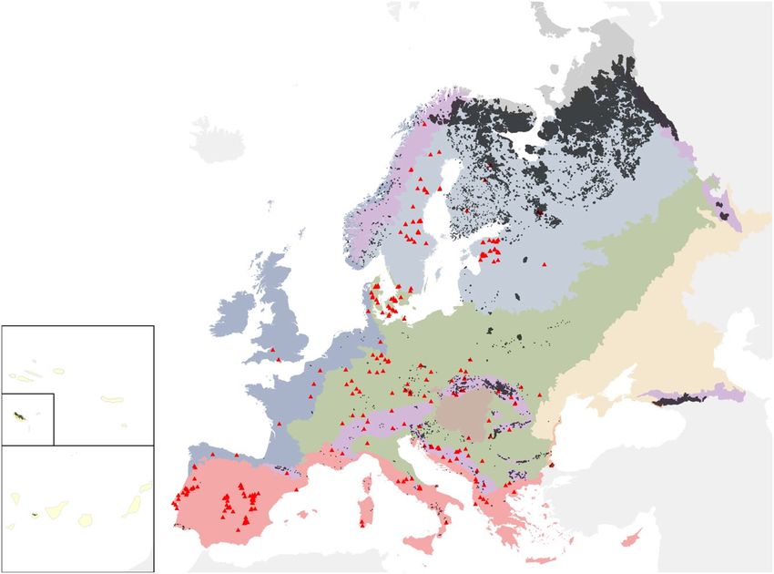
www.nature.com/scientificdata/                                                                       www.nature.com/scientificdata

                            Fig. 2 Overview of the maps of potential primary forests of Sweden and Norway.

                            polygons smaller than 2 ha (i.e., the minimum mapping unit originally used). If available, we included a set of
                            basic descriptors for each patch: name, location, naturalness level (based on35), extent, dominant tree species,
                            disturbance history and protection status. In total, our map harmonizes 48 regional-to-continental datasets of
                            primary forests (Online-only Table 1). All data is open-access33, except for three datasets that we kept confiden-
                            tial, either for conservation or copyright reasons. These datasets are: ‘Hungarian Forest Reserve monitoring’ (ID
                            17, custodian: Ferenc Horváth); ‘Ancient and Primeval Beech Forests of the Carpathians and Other Regions of
                            Europe’40,41 (ID 34, copyright: UNESCO), and ‘Potential OGF and primary forest in Austria’ (ID 48, custodian:
                            Matthias Schickhofer). Additional non-open access polygons also exist for the dataset ‘Strict Forest Reserves in
                            Switzerland’ (ID 30, custodian: Jonas Stillhard). These data are here referred to for transparency, but are neither
                            included in the statistics and summaries reported here, nor in any of the remote-sensing analysis below.

                            Post-processing.         To provide common descriptions for all features contained in the geodatabase, we inte-
                            grated the basic descriptors detailed above with a range of attributes derived by intersecting all polygons or points
                            of primary forests with layers of: 1) biogeographical regions, 2) protected areas, 3) forest type, and 4) forest cover.
                                We used the map of biogeographical regions42 to assign each primary forest point or polygon to one of the
                            following ten classes: 1. Alpine, 2. Arctic, 3. Atlantic, 4. Black Sea, 5. Boreal, 6. Continental, 7. Macaronesia, 8.
                            Mediterranean, 9. Pannonian, 10. Steppic. Similarly, we derived information on protection status and time since
                            onset of protection for each primary forest polygon or point based on the World Database on Protected Areas
                            (WDPA - https://www.protectedplanet.net). We simplified the original IUCN classification to three classes: 1.
                            strictly protected – (IUCN category I); 2. protected – (IUCN categories II-VI + not classified); 3. not protected.
                            This is a conservative aggregation recognizing the fact that, in certain contexts, logging and salvage logging are
                            allowed inside national parks, at least in the buffer zone. In case of polygons, we considered a primary forest patch
                            as protected if > 75% of its surface was within a WDPA polygon. When better information on the protection sta-
                            tus of a forest patch was available directly from data contributors, we gave priority to this source. We also assigned
                            each primary forest polygon or point to one of the forest categories defined by the European Environmental
                            Agency43. The spatial information was derived by simplifying the map of Potential Vegetation types for Europe44,
                            after creating an expert-based cross-link table21, which ties together forest categories and potential vegetation
                            types reported in Table 4.1 from43. After excluding forest plantations, the remaining 13 categories comprised: 1.
                            Boreal forest; 2. Hemiboreal forest and nemoral coniferous and mixed broadleaved-coniferous forest; 3. Alpine
                            coniferous forest; 4. Acidophilous oakwood and oak-birch forest; 5. Mesophytic deciduous forest; 6. Lowland to
                            submountainous beech forest; 7. Mountainous beech forest; 8. Thermophilous deciduous forest; 9. Broadleaved

Scientific Data |   (2021) 8:220 | https://doi.org/10.1038/s41597-021-00988-7                                                                    4
www.nature.com/scientificdata/                                                                       www.nature.com/scientificdata

                                  Woodland key Habitats               Forest with Conservaon
                                                                                value

                                                                         Forest Core areas

                                          Union

                                         Intersect                    Map of forest connuity

                                                                        Protected Mountain
                                          Merge                          Coniferous forests

                                       Reverse Clip                    Clear cuts and fellings

                                  Potenal Primary Forests
                                        of Sweden

                            Fig. 3 Workflow and data sources for the map of potential primary forests in Sweden. Data on woodland key
                            habitats derive from60 (see also: https://www.skogsstyrelsen.se); forest with conservation value from61,62, forest
                            core areas from63, continuity forests from64,65, protected mountain coniferous forests from66, clear cuts and
                            fellings from https://www.skogsstyrelsen.se.

                            evergreen forest; 10. Coniferous forests of the Mediterranean, Anatolian and Macaronesian regions; 11. Mire
                            and swamp forest; 12. Floodplain forest; 13. Non-riverine alder, birch or aspen forest. For each primary forest
                            polygon (but not for points), we reported the two most common forest categories. Finally, we extracted for each
                            primary forest polygon the actual share covered by forest. We did this, because larger primary forest polygons
                            in high naturalness classes can encompass land temporarily or permanently not covered by trees. We used a tree
                            cover density map for the year 2010 for these regions from45. All post-processing was performed in R (v3.6.1)46.

                            Potential primary forests of Sweden and Norway.                    For Sweden and Norway, where abundant geo-
                            graphic information was available on forest distribution, we created maps of potential (but so far unconfirmed)
                            primary forests. For Sweden, we derived a workflow to create a map of potential primary forests as detailed in
                            Fig. 3. This yielded 14,300 polygons covering a total area of 2.4 Mha.
                                For Norway, even though we were able to include two datasets of confirmed primary forests, additional pri-
                            mary forest is expected to exist. Therefore, we derived a map of potential primary forests, based on the “Viktige
                            Naturtyper” dataset from the Norwegian Environment Agency47, which maps different habitat types of high con-
                            servation value both inside and outside forested areas. We extracted all polygons larger than 10 ha classified as
                            “old forest types” (=“gammelskog”), i.e., forests that have never been clearcut and are in age classes of 120 years or
                            older. This yielded 2,103 polygons covering a total area of 0.1 Mha.
                                Importantly, these layers were neither directly integrated in our composite map, nor used to calculate country
                            level statistics as they only represent a first approximation of the primary forest situation in these countries, so
                            far without ground validation. Yet, we included these layers in our geodatabase with the goal of directing future
                            ground-based mapping efforts.

                            Data Records
                            The EPFD v2.033 is composed of 48 individual datasets (Online-only Table 1) and the two layers of potential
                            primary forests for Sweden and Norway. We integrated the 48 datasets into two composite feature classes, after
                            excluding all duplicated\overlapping polygons across individual datasets.
                             1) EU_PrimaryForests_Polygons_OA_v20

                                   •   Composite feature class combining the forest patches classified as “primary forest” based on polygon
                                       data sources described in Online-only Table 1
                                   •   Data type: Polygon Feature Class

                              2) EU_PrimaryForests_Points_OA_v20

                                   •   Composite feature class combining forest locations classified as “primary forest”, based on point data
                                       sources described in Online-only Table 1. Only points not overlapping with polygons in (1) reported.
                                   •   Data type: Point Feature Class

Scientific Data |   (2021) 8:220 | https://doi.org/10.1038/s41597-021-00988-7                                                                    5
www.nature.com/scientificdata/ www.nature.com/scientificdata
Mapped / Reported (Ratio)
>1
0.5-1
0.2-0.5
0.1-0.2
0.01-0.1www.nature.com/scientificdata/ www.nature.com/scientificdata
Fig. 5 Workflow of the assessment of recent human disturbance in primary forest polygons.
case of Czechia, Slovakia, Poland and Romania, our data only accounted for 20–100% of the country-level esti-
mates from Forest Europe10. For Austria, Switzerland and Hungary, instead, additional data on primary forests
exists but it is not currently open-access, and therefore not considered here. The largest data gaps were in Sweden,
Italy, Bulgaria, Estonia, Denmark and Russia, where our map accounted for less than 10% of the primary forest
reported in Forest Europe10. The low data completeness found for Denmark likely depends on the inclusion of
minimum-intervention forest reserves in Forest Europe (see49) that were harvested until recently and therefore
do not qualify as primary forests according to our definition.
Assessing recent human disturbance with remote sensing. Since our data were collected continu-
ously over the last two decades, we cannot exclude that some forest patches may have undergone human distur-
bance after data collection. This is particularly relevant for areas where primary forests are lost at high rates, such
as the Carpathians, Russian Karelia, or Northern Fennoscandia18–20. To assess to what extent this might be an
issue, we used the open-access Landsat archive and the LandTrendr disturbance detection algorithm50,51, using
Google Earth Engine52 (Fig. 5). Specifically, we 1) quantified the proportion of polygons in our map that under-
went disturbance between 1985 and 2018, i.e., Landsat 5 operating time, 2) visually checked a stratified random
selection of these disturbed polygons to quantify the prevalence of anthropogenic vs. natural disturbance, and 3)
estimated the proportion of polygons in our map not meeting the necessary, but not sufficient, condition for being
classified as primary (i.e. not being affected by anthropogenic disturbance within the last 35 years).
For each polygon contained in the map of primary forests, we extracted the whole stack of available Landsat
images (~1985-today), and ran the LandTrendr53 algorithm. LandTrendr identifies breakpoints in spectral time
Scientific Data | (2021) 8:220 | https://doi.org/10.1038/s41597-021-00988-7 7www.nature.com/scientificdata/ www.nature.com/scientificdata
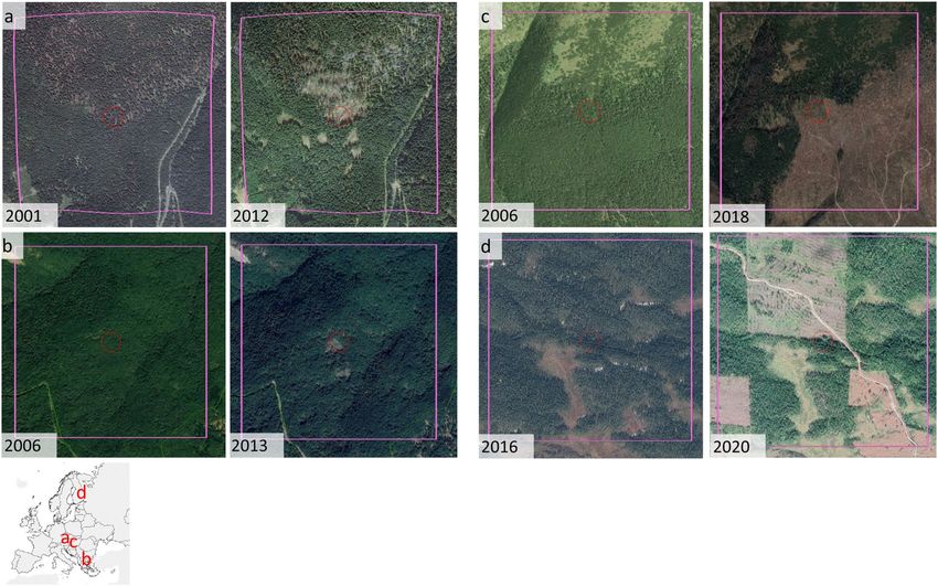
Fig. 6 Examples of disturbed polygons, as detected by LandTrendr, before (left) and after (right) disturbance.
(a) Natural disturbance in Babia Gora, Slovakia; (b) natural disturbance in the southern Bourgas Province of
Bulgaria; (c) clear-cuts in Tatra National Park in Slovakia; (d) clearcuts in the Russian Republic of Karelia. Red
circles are centred on the disturbed pixel randomly selected for visual inspection, and have a radius of 50 m;
pink squares have a side of 1 km and were exclusively used to provide context reference to the photointerpreter.
Image credits: Google Earth.
series, separates periods of disturbance or stability, and records the years in which disturbances occurred. To
avoid problems due to cloud cover, changes in illumination, and atmospheric condition, we used all available
images from the growing season of each year (1 May through 15 September) to derive yearly composite images54.
As our spectral index, we used Tasseled Cap Wetness (TCW), as this index is particularly sensitive to forest
structure55, is robust to spatial and temporal variations in canopy moisture56, and consistently outperforms other
spectral indices, including Normalized Difference Vegetation Index53, for detecting forest disturbance50,57–59. As
input parameters for the LandTrendr algorithm when detecting forest disturbances, we used a prevalue of −300
TCW units, a minimum disturbance magnitude of 500 TCW units, and a maximum duration of 4 years.
After running LandTrendr, we eliminated noise by applying a minimum disturbance threshold (2 ha). We
then visually inspected a stratified random selection of primary forest polygons highlighted as ‘disturbed’ by
LandTrendr using very-high-resolution images available in Google Earth. For each biogeographic region, we
randomly selected 20% of disturbed polygons up to a maximum of 100 polygons per region. Depending on the
size of the polygons, we inspected up to 5 randomly selected disturbed pixels within each disturbed polygon with
a minimum distance between pixels of 1 km. Based on the spectral and physical characteristics of the disturbed
patch (brightness, shape, size), and on ancillary information derived from the Google Earth imagery, we assigned
disturbance agents as either anthropogenic (i.e., forest harvest, infrastructure development) or natural (e.g.,
windstorm, bark beetle outbreak, fire; Figs. 6, 7). We conservatively considered a polygon as anthropogenically
disturbed if at least a third of the points we checked for that polygon were anthropogenically disturbed. To avoid
introducing an observer bias, all polygons were checked by the same photo-interpreter (FMS).
Out of the 17,309 polygons checked with LandTrendr, 4,734 (27.3% of total) experienced major disturbances
between 1985 and 2018. The proportion of disturbed area was greater than 10% in 2,904 polygons. We visually
inspected a total of 712 pixels across 268 primary forest polygons, corresponding to 1.5% of the total number
of polygons and 5.7% of the disturbed polygons. We attributed a total of 149 pixels, across 61 primary forest
polygons, to anthropogenic disturbance, i.e., 22.7% (bootstrapped standard error = 2.5%) of the polygons we
checked (Table 2, Fig. 7). We thus estimated the total number of primary forest polygons being anthropogenically
disturbed by multiplying the total number of polygons with the proportion of disturbed polygons (27.3%) and
the share of these disturbed polygons attributed to anthropogenic causes (22.7%). This suggests our map con-
tains 1,077 anthropogenically disturbed polygons (95% CIs [847, 1323]), which corresponds to 6.2% (95% CIs
[4.9%, 7.6%]) of the total number of polygons. Disturbed polygons were concentrated in the Russian Federation
(especially in Archangelsk region, Karelia and Komi republics), Southern Finland, and the Carpathians (Fig. 7;
Table 2). The Boreal and Alpine biogeographical regions had the highest number of disturbed polygons (both
Scientific Data | (2021) 8:220 | https://doi.org/10.1038/s41597-021-00988-7 8www.nature.com/scientificdata/ www.nature.com/scientificdata
Fig. 7 Geographical distribution of naturally vs. anthropogenically disturbed polygons, as resulting from a
visual check of 712 pixels across 268 polygons.
Num. of (3) with Share of (3)
Biogeographic Num. PF Num. disturbed Num. disturbed PF evident anthropogenic anthropogenically
region polygons (1) PF polygons (2) polygons checked (3) disturbance(4) disturbed (4/3) %
Alpine 11,734 1,096 102 23 22.55
Arctic 96 105† 20 0 0
Atlantic 83 48 13 0 0
Black Sea 19 6 1 0 0
Boreal 4,074 3,334 110 30 27.27
Continental 1,100 105 21 6 28.57
Macaronesia 27 8 2 1 50
Mediterranean 132 27 5 1 20
Pannonian 39 4 1 0 0
Steppic 5 1 0 0 0
Table 2. Recent human disturbance in primary forest polygons, summarized by biogeographical region. †The
number of disturbed polygons is higher than the total number of polygons because some polygons expanding
over more than one biogeographical region were split. PF – Primary Forest.
in total, and when considering only those with evident anthropogenic disturbance). The regions with the high-
est share of anthropogenically disturbed polygons were the Continental and Boreal region. The sample size in
Macaronesia was too low to provide a reliable estimation of the incidence of human disturbance.
These estimates should be considered as lower bounds, because only the disturbance events with a magnitude
sufficient to be captured with LandTrendr and occurring in 1985–2018 could be identified. Not being this a for-
mal validation, the results presented here should not be extrapolated to primary forests not included in our map.
Finally, being our database built with a bottom-up approach, we are unable to exclude the existence of remaining
bias or interpretation error, which might have propagated through the successive steps required to build it. As
such, we warn the users against possible heterogeneity in data quality, accuracy and completeness across datasets.
Usage Notes
All data files are referenced in a geographic coordinate system (lat/long, WGS 84 - EPSG code: 4326). The pro-
vided files are in a personal geodatabase, and can be accessed and displayed using standard GIS software such as:
QGIS (www.qgis.org/en).
All datasets listed in Online-only Table 1 are freely available in Figshare (https://doi.org/10.6084/
m9.figshare.13194095.v1)33 with a Creative Commons CC BY 4.0 license. Two additional non open-access data-
sets are available on request to the corresponding author after approval of the respective copyright holders. These
datasets are: ‘Hungarian Forest Reserve monitoring’ (ID 17, custodian: Ferenc Horváth); and ‘Potential OGF and
primary forest in Austria’ (ID 48, custodian: Matthias Schickhofer). The same conditions apply for additional data
Scientific Data | (2021) 8:220 | https://doi.org/10.1038/s41597-021-00988-7 9www.nature.com/scientificdata/ www.nature.com/scientificdata
from the dataset ‘Strict Forest Reserves in Switzerland’ (ID 30, custodian: Jonas Stillhard). In the case of the data-
set ‘Ancient and Primeval Beech Forests of the Carpathians and Other Regions of Europe’40,41 (ID 34, Custodian:
UNESCO), this data is freely available online, but its copyright does not allow redistribution. We refer the inter-
ested reader to the website https://www.protectedplanet.net/903141 for the original data.
Comments and requests of updates for the dataset are collected and discussed in the GitHub forum: https://
github.com/fmsabatini/PrimaryForestEurope.
Code availability
The code to reproduce the composite layers, for post-processing and for assessing recent human disturbance with
remote sensing is available together with the database in Figshare (https://doi.org/10.6084/m9.figshare.13194095.v1)33.
We included seven scripts:
• 00_ComposeMap.R – Identifies overlapping polygons across individual datasets.
• 01_CreateComposite_Points.py – Creates the composite point feature class.
• 02_CreateComposite_Polygons.py – Creates the composite polygon feature class.
• 03_PostProcessing.R – Extracts additional information on each primary forest.
• 04_Add_Postprocessing.py – Imports post-processing output into the geodatabase.
• 05_Summary_stats.R – Calculates summary statistics of primary forests
• 06_DisturbanceAssessment_Step1_exportIntermediateChangeImg.txt – Runs LandTrendr in Google Earth
Engine, tiles the area of interest, creates Change-Images for each tile, and exports these as intermediate .tif
files containing the LandTrendr metrics.
• 07_DisturbanceAssessment_Step2_extractPolygonValuesFromChangeImg.txt – Extracts LandTrendr metrics
for each forest polygon from Change-Images and exports as .csv.
Python (.py) scripts were run in ESRI ArcGIS (v10.5) and are available also as ArcGIS Models inside the
Geodatabase. R (.R) scripts were run using R (v 3.6.1)46. The remaining .txt scripts were run in Google Earth
Engine.
Received: 17 November 2020; Accepted: 6 July 2021;
Published: xx xx xxxx
References
1. Watson, J. E. M. et al. The exceptional value of intact forest ecosystems. Nat. Eco. Evo. 2, 599–610 (2018).
2. European Commission. in COM(2020) 380 final (Brussels, 2020).
3. Vandekerkhove, K. et al. Reappearance of Old-Growth Elements in Lowland Woodlands in Northern Belgium: Do the Associated
Species Follow? Silva Fenn. 45, 909–935 (2011).
4. Di Marco, M., Ferrier, S., Harwood, T. D., Hoskins, A. J. & Watson, J. E. Wilderness areas halve the extinction risk of terrestrial
biodiversity. Nature 573, 582–585 (2019).
5. Frey, S. J. K. et al. Spatial models reveal the microclimatic buffering capacity of old-growth forests. Sci. Adv. 2, e1501392 (2016).
6. Zhou, G. Y. et al. Old-growth forests can accumulate carbon in soils. Science 314, 1417–1417 (2006).
7. Burrascano, S., Keeton, W. S., Sabatini, F. M. & Blasi, C. Commonality and variability in the structural attributes of moist temperate
old-growth forests: A global review. For. Ecol. Manag. 291, 458–479 (2013).
8. Bauhus, J., Puettmann, K. & Messier, C. Silviculture for old-growth attributes. For. Ecol. Manag. 258, 525–537 (2009).
9. Moore, K. D. In the shadow of the cedars: the spiritual values of old-growth forests. Conserv. Biol. 21, 1120–1123 (2007).
10. FOREST EUROPE. State of Europe’s Forests 2015. (Ministerial Conference on the Protection of Forests in Europe, Madrid, 2015).
11. Ceccherini, G. et al. Abrupt increase in harvested forest area over Europe after 2015. Nature 583, 72–77 (2020).
12. Levers, C. et al. Drivers of forest harvesting intensity patterns in Europe. For. Ecol. Manag. 315, 160–172 (2014).
13. Potapov, P. et al. The last frontiers of wilderness: Tracking loss of intact forest landscapes from 2000 to 2013. Sci. Adv. 3 (2017).
14. Schickhofer, M. & Schwarz, U. Inventory of Potential Primary and Old-Growth Forest Areas in Romania (PRIMOFARO). Identifying
the largest intact forests in the temperate zone of the European Union. (Euronatur Foundation, 2019).
15. Knorn, J. et al. Continued loss of temperate old-growth forests in the Romanian Carpathians despite an increasing protected area
network. Environ. Conserv. 40, 182–193 (2013).
16. Court of Justice of the European Union. C-441/17 - Commission v Poland (Forêt de Białowieża) Judgment of the Court (Grand
Chamber) of 17 April 2018 (2018).
17. Chylarecki, P. & Selva, N. Ancient forest: spare it from clearance. Nature 530, 419–419 (2016).
18. Earthsight. Complicit in corruption. How billion-dollar firms and EU governments are failing Ukraine’s forests. (Earthsight, 2018).
19. Mikoláš, M. et al. Primary forest distribution and representation in a Central European landscape: Results of a large-scale field-based
census. For. Ecol. Manag. 449, 117466 (2019).
20. Hance, J. IKEA Logging Old-growth Forest for Low-price Furniture in Russia. https://news.mongabay.com/2012/05/ikea-logging-
old-growth-forest-for-low-price-furniture-in-russia/ (2012).
21. Sabatini, F. M. et al. Protection gaps and restoration opportunities for primary forests in Europe. Divers. Distrib. 26, 1646–1662
(2020).
22. Barredo Cano, J. I. et al. Mapping and assessment of primary and old-growth forests in Europe. (EUR 30661 EN, Publications Office of
the European Union, 2021).
23. Adam, D. & Vrška, T. Important localities of old-growth forests in Landscape Atlas of the Czech Republic (eds T Hrnčiarová, P
Mackovčin, & I Zvara) (Ministry of Environment and Silva Tarouca Research Institute, Prague–Silva Tarouca Research Institute for
Landscape and Ornamental Gardening, 2009).
24. Diaci, J. Virgin forests and forest reserves in Central and East European countries-History, present status and future development.
Proceedings of the invited lecturers’ reports presented at the COST E4 management committee and working groups meeting in Ljubljana,
Slovenia (1999).
25. Kirchmeir, H. & Kovarovics, A. Nomination Dossier “Primeval Beech Forests of the Carpathians and Other Regions of Europe“ as
extension to the existing Natural World Heritage Site “Primeval Beech Forests of the Carpathians and the Ancient Beech Forests of
Germany” (1133bis). (2016).
26. García Feced, C., Berglund, H. & Strnad, M. Scoping document: information related to European old growth forests. (ETC/BD
report to the EEA, 2015).
Scientific Data | (2021) 8:220 | https://doi.org/10.1038/s41597-021-00988-7 10www.nature.com/scientificdata/ www.nature.com/scientificdata
27. Veen, P. et al. Virgin forests in Romania and Bulgaria: results of two national inventory projects and their implications for protection.
Biodivers. Conserv. 19, 1805–1819 (2010).
28. Ibisch, P. L. & Ursu, A. Potential primary forests of Romania. (Greenpeace CEE Romania; Centre for Econics and Ecosystem
Management, Eberswalde University for Sustainable Development; Geography Department, A. I. Cuza University of Iași, 2017).
29. Spracklen, B. D. & Spracklen, D. V. Identifying European Old-Growth Forests using Remote Sensing: A Study in the Ukrainian
Carpathians. Forests 10, 127 (2019).
30. Frank, G. et al. COST Action E27. Protected Forest Areas in Europe-analysis and harmonisation (PROFOR): results, conclusions and
recommendations. (Federal Research and Training Centre for Forests, Natural Hazards and Landscape (BFW), 2007).
31. Sabatini, F. M. et al. Where are Europe’s last primary forests? Divers. Distrib. 24, 1426–1439 (2018).
32. McRoberts, R. E., Susanne, W., Gherardo, C. & Elizabeth, L. Assessing Forest Naturalness. For. Sci. 58, 294–309 (2012).
33. Sabatini, F. M. et al. European Primary Forest Database. figshare https://doi.org/10.6084/m9.figshare.13194095.v1 (2020).
34. FAO. Global Forest Resources Assessment 2015. Terms and definitions. (FAO, 2015).
35. Buchwald, E. A hierarchical terminology for more or less natural forests in relation to sustainable management and biodiversity
conservation in Proceedings: Third expert meeting on harmonizing forest-related definitions for use by various stakeholders (Food and
Agriculture Organization of the United Nations, 2005).
36. Blasi, C., Burrascano, S., Maturani, A. & Sabatini, F. M. Old-growth forests in Italy. (Palombi Editori, 2010).
37. Cateau, E. et al. Le patrimoine forestier des réserves naturelles. Focus sur les forêts à caractère naturel. Cahier n°7. (Réserves Naturelles
de France, 2017).
38. Svoboda, M. et al. Landscape-level variability in historical disturbance in primary Picea abies mountain forests of the Eastern
Carpathians, Romania. J. Veg. Sci. 25, 386–401 (2014).
39. Potapov, P. et al. Mapping the world’s intact forest landscapes by remote sensing. Ecol. Soc. 13 (2008).
40. Britz, H. et al. Nomination of the “Ancient Beech Forests of Germany” as Extension to the World Natural heritage “Primeval Beech
Forests of the Carpathians”. Nationale Naturlandschaften, Federal Republic of Germany. Nieden-stein: Specialised editing Cognitio
Kommunikation & Planung (2009).
41. UNEP-WCMC & IUCN. Protected Area Profile for Ancient and Primeval Beech Forests of the Carpathians and Other Regions of
Europe from the World Database of Protected Areas https://www.protectedplanet.net/903141 (2019).
42. EEA. Biogeographical regions of Europe https://www.eea.europa.eu/data-and-maps/data/biogeographical-regions-europe-3 (2016).
43. EEA. European forest types. Categories and types for sustainable forest management reporting and policy. (EEA Technical Report
No 9/2006. EEA, Copenhagen, 2006).
44. Bohn, U. et al. Map of the natural vegetation of Europe. Explanatory text with CD-ROM, (German Federal Agency for Nature
Conservation, Bonn, Germany, 2003).
45. Hansen, M. C. et al. High-resolution global maps of 21st-century forest cover change. Science 342, 850–853 (2013).
46. R Development Core Team. R: A language and environment for statistical computing v. 3.6.1. R Foundation for Statistical Computing
http://www.R-project.org/ (2019).
47. Miljødirektoratet. (2016).
48. FAO. Global Forest Resources Assessment 2015. Desk reference. 245 (FAO, Rome, 2015).
49. FOREST EUROPE. Quantitative Indicators Country reports 2015 https://foresteurope.org/state-europes-forests-2015-report/#
1476295965372-d3bb1dd0-e9a0 (2015).
50. Cohen, W. B., Yang, Z., Healey, S. P., Kennedy, R. E. & Gorelick, N. A LandTrendr multispectral ensemble for forest disturbance
detection. Remote Sens. Environ. 205, 131–140 (2018).
51. Kennedy, E. R. et al. Implementation of the LandTrendr Algorithm on Google Earth Engine. Remote Sensing 10 (2018).
52. Gorelick, N. et al. Google Earth Engine: Planetary-scale geospatial analysis for everyone. Remote Sens. Environ. 202, 18–27 (2017).
53. Kennedy, R. E., Yang, Z. & Cohen, W. B. Detecting trends in forest disturbance and recovery using yearly Landsat time series: 1.
LandTrendr—Temporal segmentation algorithms. Remote Sens. Environ. 114, 2897–2910 (2010).
54. Griffiths, P., Van Der Linden, S., Kuemmerle, T. & Hostert, P. A pixel-based landsat compositing algorithm for large area land cover
mapping IEEE Journal of Selected Topics in Applied Earth Observations and Remote Sensing 6, 2088–2101 (2013).
55. Cohen, W. B. & Spies, T. A. Estimating structural attributes of Douglas-fir/western hemlock forest stands from Landsat and SPOT
imagery. Remote Sens. Environ. 41, 1–17 (1992).
56. Czerwinski, C. J., King, D. J. & Mitchell, S. W. Mapping forest growth and decline in a temperate mixed forest using temporal trend
analysis of Landsat imagery, 1987–2010. Remote Sens. Environ. 141, 188–200 (2014).
57. Cohen, W. B., Yang, Z. & Kennedy, R. Detecting trends in forest disturbance and recovery using yearly Landsat time series: 2.
TimeSync—Tools for calibration and validation. Remote Sens. Environ. 114, 2911–2924 (2010).
58. Grogan, K., Pflugmacher, D., Hostert, P., Kennedy, R. & Fensholt, R. Cross-border forest disturbance and the role of natural rubber
in mainland Southeast Asia using annual Landsat time series. Remote Sens. Environ. 169, 438–453 (2015).
59. De Marzo, T. et al. Characterizing forest disturbances across the Argentine Dry Chaco based on Landsat time series. International
Journal of Applied Earth Observation and Geoinformation 98, 102310 (2021).
60. Frank, A. Inventering av nyckelbiotoper: resultat till och med 2003. (Skogsstyr., 2004).
61. Länsstyrelsen Västerbotten. LstAC Skogar med höga naturvärden ovan gränsen för fjällnära skog 2003–2015 https://ext-
geodatakatalog.lansstyrelsen.se/GeodataKatalogen/ (2019).
62. Naturvårdsverket. Skyddsvärda statliga skogar http://mdp.vic-metria.nu/miljodataportalen/GetMetaDataById?UUID=3919E66E-
2E09-440D-9171-B5074DF0C0ED (2017).
63. Naturvårdsverket. Skogliga värdekärnor http://gpt.vic-metria.nu/data/land/skogliga_vardekarnor_2016.zip (2016).
64. Naturvårdsverket. Preciserad kartering av kontinuitetsskog i Jämtlands län http://gpt.vic-metria.nu/data/land/Preciserad_kskog_
jamtland.zip (2019).
65. Ahlkrona, E., Giljam, C. & Wennberg, S. Kartering av kontinuitetsskogi boreal region. Metria AB på uppdrag av Naturvårdsverket
(2017).
66. Naturvårdsverket. Skyddad fjallbarrskog https://gpt.vic-metria.nu/data/land/NMD/Skyddad_Fjallbarrskog.zip (2019).
67. Trotsiuk, V. et al. A mixed severity disturbance regime in the primary Picea abies (L.) Karst. forests of the Ukrainian Carpathians.
For. Ecol. Manag. 334, 144–153 (2014).
68. Kozák, D. et al. Profile of tree-related microhabitats in European primary beech-dominated forests. For. Ecol. Manag. 429, 363–374
(2018).
69. Garbarino, M. et al. Gap disturbances and regeneration patterns in a Bosnian old-growth forest: a multispectral remote sensing and
ground-based approach. Ann. For. Sci. 69, 617–625 (2012).
70. Keren, S. et al. Comparative Structural Dynamics of the Janj Mixed Old-Growth Mountain Forest in Bosnia and Herzegovina: Are
Conifers in a Long-Term Decline? Forests 5, 1243–1266 (2014).
71. Motta, R. et al. Structure, spatio-temporal dynamics and disturbance regime of the mixed beech–silver fir–Norway spruce old-
growth forest of Biogradska Gora (Montenegro). Plant Biosyst. 149, 966–975 (2015).
72. Motta, R. et al. Development of old-growth characteristics in uneven-aged forests of the Italian Alps. Eur. J. For. Res. 134, 19–31
(2015).
73. Panayotov, M. et al. Mountain coniferous forests in Bulgaria – structure and natural dynamics. (University of Forestry and Geosoft,
2016).
Scientific Data | (2021) 8:220 | https://doi.org/10.1038/s41597-021-00988-7 11www.nature.com/scientificdata/ www.nature.com/scientificdata
74. Lõhmus, A. & Kraut, A. Stand structure of hemiboreal old-growth forests: Characteristic features, variation among site types, and a
comparison with FSC-certified mature stands in Estonia. For. Ecol. Manag. 260, 155–165 (2010).
75. EEA. Developing a forest naturalness indicator for Europe. Concept and methodology for a high nature value (HNV) forest indicator.
(EEA Technical report No 13/2014, Luxembourg: Publications Office of the European Union, 2014).
76. Rossi, M., Bardin, P., Cateau, E. & Vallauri, D. Forêts anciennes de Méditerrané e et des montagnes limitrophes: références pour la
naturalité régionale. WWF France, Marseille, France, 144 (2013).
77. Myhre, T. Skogkur 2020. redningsplan for Norges unike skoger. WWF Verdens villmarksfond, Norges naturvernforbund, SABIMA
(2012).
78. Ruete, A., Snäll, T. & Jönsson, M. Dynamic anthropogenic edge effects on the distribution and diversity of fungi in fragmented old-
growth forests. Ecol. Appl. 26, 1475–1485 (2016).
79. Heiri, C., Wolf, A., Rohrer, L., Brang, P. & Bugmann, H. Successional pathways in Swiss mountain forest reserves. Eur. J. For. Res.
131, 503–518 (2012).
80. Brang, P., Heiri, C. & Bugmann, H. Waldreservate: 50 Jahre natürliche Waldentwicklung in der Schweiz. (Haupt, 2011).
81. Pantić, D. et al. Structural, production and dynamic characteristics of the strict forest reserve’Račanska šljivovica’on Mt. Tara. Glasnik
Šumarskog fakulteta, 93–114 (2011).
82. Savoie, J. M. et al. Vieilles forêts pyrénéennes de Midi-Pyrénées. Deuxième phase. Evaluation et cartographie des sites. Recommandations.
Rapport final. (Ecole d’Ingénieurs de PURPAN/DREAL Midi-Pyrénées, 2015).
83. Savoie, J. M. et al. Forêts pyrénéennes anciennes de Midi-Pyrénées. Rapport d’Etude de projet FEDER 2008–2011. 320 (Ecole
d’Ingénieurs de PURPAN/DREAL Midi-Pyrénées, 2011).
84. WWF Finland. Kansallisomaisuus turvaan - valtion omistamia suojelun arvoisia metsä- ja suoalueita, (WWF Suomen raportteja,
2012).
85. Kitenberga, M. et al. A mixture of human and climatic effects shapes the 250-year long fire history of a semi-natural pine dominated
landscape of Northern Latvia. For. Ecol. Manag. 441, 192–201 (2019).
86. Baders, E., Senhofa, S., Purina, L. & Jansons, A. Natural succession of Norway spruce stands in hemiboreal forests: case study in
Slitere national park, Latvia. Baltic Forestry 23, 522–528 (2017).
87. Kokarēviča, I. et al. Vegetation changes in boreo–nemoral forest stands depending on soil factors and past land use during an 80 year
period of no human impact. Can. J. For. Res. 46, 376–386 (2016).
88. Fernandez López, A. B. Parque Nacional de Garajonay, Patrimonio Mundial. (Organismo Autonomo Parques Nacionales, 2009).
89. TRAGSATEC. Segundo inventario ecológico del Parque Nacional de Garajonay. (Parque Nacional de Garajonay, 2006).
90. Fernández, A. B. & Gómez, L. Qué son los bosques antiguos de laurisilva. Su valor y situación en Canarias. La Gomera, entre bosques
y taparuchas, 177–236 (2016).
91. Matović, B. et al. Comparison of stand structure in managed and virgin european beech forests in Serbia. Šumarski list 142, 47–57
(2018).
92. Kiš, A., Stojšić, V., & Dinić, A. In 2nd International Symposium on Nature Conservation. Proceedings 373–382 (Institute for Nature
Conservation of Vojvodina Province, Novi Sad, 2016).
93. Kobyakov, K. & Jakolev, J. Atlas of high conservation value areas, and analysis of gaps and representativeness of the protected area
network in northwest Russia. (Finnish Environment Institute, 2013).
94. Diku, A. & Shuka, L. Pyjet e vjetër të ahut në shqipëri (Old Beech forests in Albania). (PSEDA - ILIRIA, 2017).
95. Burrascano, S. et al. It’s a long way to the top: Plant species diversity in the transition from managed to old-growth forests. J. Veg. Sci.
29, 98–109 (2018).
Acknowledgements
This project was funded by Frankfurt Zoological Society (FZS; project ETN-WIE-FZS-001) and the European
Commission (Marie Sklodowska‐Curie fellowship to FMS, project FORESTS & CO, #658876). The Italian
dataset was supported by funding from the Department for Nature Protection of the Italian Ministry of the
Environment, Land and Sea Protection. The GEVFP’s French dataset was supported by funding from EU, RF and
‘Conseil Régional Midi-Pyrénées’. MM gratefully acknowledges the Czech Science Foundation (Grant GACR
no. 21-27454S), as well as the institutional project EVA No.CZ.02.1.01/ 0.0/0.0/16_019/0000803. The Serbian
dataset was supported by the Ministry of Education, Science and Technological Development of the Republic of
Serbia, grant number 451-03-9/2021-14/ 200197. This work would not have been possible without all those who
responded to the questionnaires and those who collected all the data presented here. A special thanks goes to all
data contributors, especially those who are not coauthors of this paper (in alphabetic order): Paloma Hannonen
(Dataset 39), Matti Liimatainen (Dataset 38), Simone Mayrhofer (Dataset 49), Daniel Vallauri (Dataset 13) and
Juraj Vysoky (Dataset 26). FMS also acknowledges the financial support within the funding programme Open
Access Publishing by the German Research Foundation (DFG). We also thank Teresa De Marzo for support
during the assessment of recent human disturbance in primary forest polygons. We thank the editor and two
anonymous reviewers for very helpful and constructive comments on prior manuscript versions.
Author contributions
The original idea for the database is from F.M.S., T.K. and Z.K., F.M.S. and H.B. harmonized the datasets, and
conducted the literature review. D.A., J.A.A., E.B., S.B., E.C., A.D., I.M.D., A.B.F., M.G., N.G., F.H., S.K., M.K.,
A.K.i., A.K.r., P.L.I., L.L., F.L., B.M., R.N.M., P.M., S.M., R.M., M.M., G.M., M.P., R.P., L.N., A.R., M.S., B.S., J.S.,
D.S., J.S., O.-P.T., E.T., R.V., T.V., M.W., M.Y., T.Z., A.Z. contributed data. F.M.S., H.B. and T.K. created the first
draft of the manuscript and all co-authors contributed substantially to its revision.
Funding
Open Access funding enabled and organized by Projekt DEAL.
Competing interests
The authors declare no competing interests.
Additional information
Correspondence and requests for materials should be addressed to F.M.S.
Reprints and permissions information is available at www.nature.com/reprints.
Scientific Data | (2021) 8:220 | https://doi.org/10.1038/s41597-021-00988-7 12www.nature.com/scientificdata/ www.nature.com/scientificdata
Publisher’s note Springer Nature remains neutral with regard to jurisdictional claims in published maps and
institutional affiliations.
Open Access This article is licensed under a Creative Commons Attribution 4.0 International
License, which permits use, sharing, adaptation, distribution and reproduction in any medium or
format, as long as you give appropriate credit to the original author(s) and the source, provide a link to the Cre-
ative Commons license, and indicate if changes were made. The images or other third party material in this
article are included in the article’s Creative Commons license, unless indicated otherwise in a credit line to the
material. If material is not included in the article’s Creative Commons license and your intended use is not per-
mitted by statutory regulation or exceeds the permitted use, you will need to obtain permission directly from the
copyright holder. To view a copy of this license, visit http://creativecommons.org/licenses/by/4.0/.
The Creative Commons Public Domain Dedication waiver http://creativecommons.org/publicdomain/zero/1.0/
applies to the metadata files associated with this article.
© The Author(s) 2021
Francesco Maria Sabatini 1,2 ✉, Hendrik Bluhm3, Zoltan Kun4, Dmitry Aksenov5,
José A. Atauri6, Erik Buchwald7, Sabina Burrascano8, Eugénie Cateau9, Abdulla Diku10,
Inês Marques Duarte 11, Ángel B. Fernández López12, Matteo Garbarino 13,
Nikolaos Grigoriadis14, Ferenc Horváth 15, Srđan Keren 16, Mara Kitenberga17, Alen Kiš 18,
Ann Kraut19, Pierre L. Ibisch 20, Laurent Larrieu21,22, Fabio Lombardi23, Bratislav Matovic24,
Radu Nicolae Melu25, Peter Meyer26, Rein Midteng27, Stjepan Mikac 28, Martin Mikoláš29,30,
Gintautas Mozgeris 31, Momchil Panayotov 32, Rok Pisek33, Leónia Nunes 34,
Alejandro Ruete 35, Matthias Schickhofer36, Bojan Simovski 37, Jonas Stillhard 38,
Dejan Stojanovic39, Jerzy Szwagrzyk40, Olli-Pekka Tikkanen41, Elvin Toromani42,
Roman Volosyanchuk 43,44, Tomáš Vrška45, Marcus Waldherr46, Maxim Yermokhin47,
Tzvetan Zlatanov 48, Asiya Zagidullina 49 & Tobias Kuemmerle50
1
German Centre for Integrative Biodiversity Research (iDiv) - Halle-Jena-Leipzig, Puschstrasse 4, 04103, Leipzig,
Germany. 2Martin-Luther-Universität Halle-Wittenberg, Institut für Biologie, Am Kirchtor 1, 06108, Halle, Germany.
3
Humboldt-Universität zu Berlin, Geography Department, Unter den Linden 6, 10099, Berlin, Germany. 4Frankfurt
Zoological Society, Bernhard-Grzimek-Allee 1, 60316, Frankfurt, Germany. 5NGO “Transparent World”, Rossolimo
str. 5/22, building 1, 119021, Moscow, Russia. 6EUROPARC-Spain/Fundación Fernando González Bernáldez. ICEI
Edificio A. Campus de Somosaguas, E28224, Pozuelo de Alarcón, Spain. 7The Danish Nature Agency, Gjøddinggård,
Førstballevej 2, DK-7183, Randbøl, Denmark. 8Sapienza University of Rome, Department of Environmental Biology,
P.le Aldo Moro 5, 00185, Rome, Italy. 9Réserves Naturelles de France, La Bourdonnerie, Dijon cedex, 21000, France.
10
PSEDA-ILIRIA. Forestry department, Tirana, 1000, Albania. 11Centre for Applied Ecology “Professor Baeta
Neves” (CEABN), InBIO, School of Agriculture, University of Lisbon, Tapada da Ajuda, 1349‐017, Lisbon, Portugal.
12
Parque Nacional de Garajonay. Avda. V Centenario, edif. Las Creces, local 1, portal 3, 38800 San Sebastian de La
Gomera, Tenerife, Spain. 13University of Torino, Department DISAFA L.go Paolo Braccini 2, Grugliasco, 10095, Italy.
14
Forest Research Institute, Vassilika, 57006, Thessaloniki, Greece. 15Centre for Ecological Research, Institute of
Ecology and Botany, Alkotmány u. 2-4., 2163, Vácrátót, Hungary. 16Faculty of Forestry, University of Agriculture in
Krakow, aleja 29-Listopada 46, 31-415, Krakow, Poland. 17Latvian State Forest Research Institute “Silava”, Rigas
street 111, Salaspils, LV-2169, Latvia. 18Institute for Nature Conservation of Vojvodina Province, Radnička 20a,
Novi Sad, 21000, Serbia. 19University of Tartu, Institute of Ecology and Earth Sciences, Vanemuise 46, EE-51014,
Tartu, Estonia. 20Centre for Econics and Ecosystem Management, Faculty of Forest and Environment, Eberswalde
University for Sustainable Development, Alfred-Möller-Str. 1, 16225, Eberswalde, Germany. 21Université de
Toulouse, INRAE, UMR DYNAFOR, 24 Chemin de Borde-Rouge Auzeville CS 52627, Castanet-Tolosan, 31326,
France. 22CRPF-Occitanie, antenne de Tarbes, place du foirail, 65000, Tarbes, France. 23Mediterranean University
of Reggio Calabria, Agraria Department, Loc. Feo di Vito, 89122, Reggio Calabria, Italy. 24University of Novi Sad,
Institute of Lowland Forestry and Environment, Antona Cehova 13d, Novi Sad, 21102, Serbia. 25World Wide Fund
for nature (CEE), Lunga street 190, Brasov, 500051, Romania. 26Northwest German Forest Research Institute,
Department Forest Nature Conservation, Professor-Oelkers-Straße 6, 34346. Hann, Münden, Germany. 27Asplan
Viak A.S.Kjörboveien 20, postboks 24, N-1300, Sandvika, Norway. 28University of Zagreb, Faculty of Forestry,
Svetosimunska cesta 25, 10000, Zagreb, Croatia. 29Czech University of Life Sciences, Faculty of Forestry and Wood
Sciences, Kamýcka cesta 1176, CZ-16521, Praha6-Suchdol, Czech Republic. 30PRALES, Odtrnovie 563, SK-01322,
Rosina, Slovakia. 31Vytautas Magnus University, K. Donelaičio g. 58, LT-44248, Kaunas, Lithuania. 32University of
Forestry, Dendrology Department, bulevard “Sveti Kliment Ohridski” 10, 1756, Sofia, Bulgaria. 33Slovenia Forest
Service, Department for forest management planning, Vecna pot 2, 1000, Ljubljana, Slovenia. 34Centre for Applied
Ecology “Professor Baeta Neves” (CEABN), InBIO, School of Agriculture, University of Lisbon, Tapada da Ajuda
1349‐017, Lisbon, Portugal. 35Greensway AB, Ulls väg 24A. 756 51, Uppsala, Sweden. 36Freelance forest expert and
book author, Vienna, Austria. 37Ss. Cyril and Methodius University in Skopje, Hans Em Faculty of Forest Sciences,
Scientific Data | (2021) 8:220 | https://doi.org/10.1038/s41597-021-00988-7 13You can also read