SHUSWAP RIVER WATERSHED ACTION PLAN - Fish and ...
←
→
Page content transcription
If your browser does not render page correctly, please read the page content below
SHUSWAP RIVER
WATERSHED ACTION PLAN
REV: August 17, 2021
     The Fish & Wildlife Compensation Program is a partnership between BC Hydro, the Province of B.C., Fisheries and Oceans Canada,
                First Nations and Public Stakeholders to conserve and enhance fish and wildlife impacted by BC Hydro dams.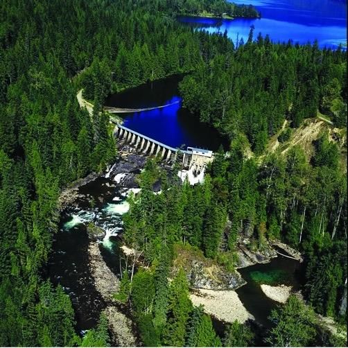
The Fish & Wildlife Compensation Program is conserving and enhancing fish and wildlife impacted by construction of BC Hydro dams
       in this watershed. From left: Sugar Lake Dam and Wilsey Dam and powerhouse (Credit BC Hydro). Cover photos: Coho fry (Credit iStock),
       Western Painted Turtle (Credit Ben Meunier).

The Fish & Wildlife Compensation Program (FWCP) is a partnership between BC Hydro, the Province of BC, Fisheries and
Oceans Canada, First Nations and Public Stakeholders to conserve and enhance fish and wildlife impacted by BC Hydro
dams. The FWCP funds projects within its mandate to conserve and enhance fish and wildlife in 14 watersheds that
make up its Coastal Region.

Learn more about the Fish & Wildlife Compensation Program, projects underway now, and how you can apply for a
grant at fwcp.ca. Subscribe to our free email updates and annual newsletter at www.fwcp.ca/subscribe. Contact us
anytime at fwcp@bchydro.com.

                                                                      2                                          Shuswap River Action Plan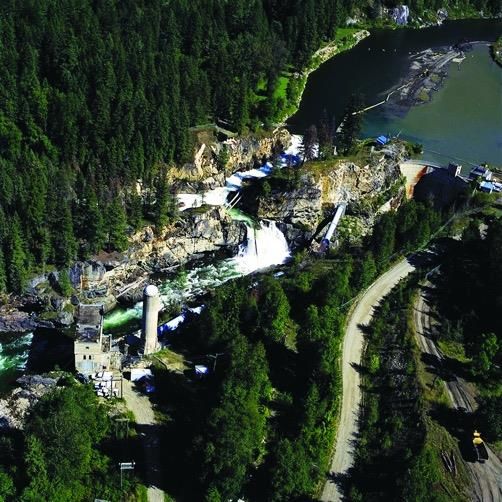
EXECUTIVE SUMMARY: SHUSWAP RIVER WATERSHED
The Fish & Wildlife Compensation Program is partnership between BC Hydro, the Province of B.C., Fisheries and Oceans
Canada, First Nations and Public Stakeholders to conserve and enhance fish and wildlife impacted by BC Hydro dams.

This Action Plan builds on the Fish & Wildlife Compensation Program’s (FWCP’s) strategic objectives, and is an update to
the previous FWCP Watershed and Action Plans. The Action Plan was developed with input from BC Hydro, Fisheries and
Oceans Canada (DFO), Canadian Wildlife Service (CWS), Ministry of Environment (MOE), Ministry of Forests, Lands and
Natural Resource Operations (FLNRO), participating First Nations, and local communities. It specifies actions that will
conserve, restore and enhance fish and wildlife species and their habitats.

This Action Plan sets out Priority Actions for the FWCP that will guide funding decisions for FWCP projects in the
Shuswap River watershed. The focus of the next five-year period will be Priority Actions identified for fish, wildlife and
habitats in three broad ecosystem categories:

    1. Rivers Lakes & Reservoirs;
    2. Wetland & Riparian Areas; and
    3. Upland & Dryland.

These ecosystem categories are described in the Ecosystem Chapters, and proposed Priority Actions are captured in the
Action Table at the end of this document. The Priority Actions are intended to support FWCP’s strategic objectives of
conservation, sustainable use, and community engagement. Priority Actions eligible for FWCP funding fall into one or
more of the following action types:

    •   Research and Information Acquisition – These actions will collect information necessary to evaluate, review and
        implement subsequent conservation, restoration and enhancement actions. Examples include inventory, limiting
        factor assessments and other activities to address data gaps and information needs to complete other actions.
    •   Habitat-based Actions – These actions will conserve, restore, and enhance habitats. Examples include habitat
        creation, restoration, and enhancement, enhancing habitat connectivity, and invasive species management.
    •   Land Securement – These actions will contribute to the establishment of easements or covenants or the
        purchase of private land for conservation purposes.
    •   Species-based Actions – These actions will alleviate limiting factors for a species. Examples include restoration
        planning, captive breeding/rearing and reintroduction.
    •   Monitoring and Evaluation – These actions will monitor and evaluate projects supported by FWCP to
        understand the effectiveness of habitat- or species-based actions.

This Action Plan, and specifically the Action Table, sets FWCP priorities for investments in compensation activities within
the watershed. However, actions may not translate into funded projects. FWCP funding limitations require priority
setting across the Coastal Region’s 14 watersheds. The process of selecting which actions will be implemented in any
given year will occur during the annual grant intake and project cycle. See fwcp.ca for more.

                                                              3                                     Shuswap River Action Plan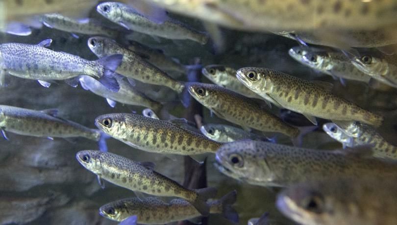
About our Action Plan
This Action Plan provides important background information about the watershed, including hydro development
projects by BC Hydro, and conservation and enhancement projects funded by the Fish & Wildlife Compensation Program
(FWCP). This Action Plan outlines our Priority Actions for fish and wildlife eligible for an FWCP grant.

Anyone interested in applying for an FWCP grant should review our Priority Actions (see Action Table) and develop a
grant application that aligns with a Priority Action(s).

Contact us to discuss our grants, Priority Actions and how we can help you develop your grant application. Subscribe and
we will keep you posted about our grants and the projects we fund. Learn more at fwcp.ca

                                                            4                                   Shuswap River Action Plan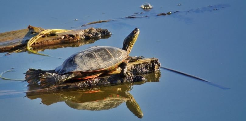
TABLE OF CONTENTS
Executive Summary: Shuswap River Watershed ..................................................................................................................... 3
Table of Contents ..................................................................................................................................................................... 5
Shuswap River Watershed Background ................................................................................................................................... 6
  Introduction ......................................................................................................................................................................... 6
  Setting .................................................................................................................................................................................. 6
  Land Ownership in the Shuswap River Watershed ............................................................................................................. 7
  Footprint Impacts and Threats ............................................................................................................................................ 8
  Objectives for the Shuswap River Watershed ..................................................................................................................... 9
  FWCP Projects Implemented: Shuswap River Watershed................................................................................................. 10
  Interactions with Other Ongoing Processes ...................................................................................................................... 11
Ecosystem Chapter: Rivers, Lakes & Reservoirs .................................................................................................................... 13
  Actions for Rivers, Lakes & Reservoirs ............................................................................................................................... 13
  Aquatic Habitat in the Shuswap River Watershed ............................................................................................................ 13
  Limiting Factors .................................................................................................................................................................. 13
  Knowledge Status .............................................................................................................................................................. 14
  Objectives and Measures................................................................................................................................................... 15
Ecosystem Chapter: Wetland & Riparian Areas .................................................................................................................... 16
  Actions for Wetland & Riparian Areas ............................................................................................................................... 16
  Wetland and Riparian Areas in the Shuswap River Watershed ........................................................................................ 16
  Limiting Factors .................................................................................................................................................................. 16
  Knowledge Status .............................................................................................................................................................. 17
  Objectives and Measures................................................................................................................................................... 18
Ecosystem Chapter: Upland & Dryland ................................................................................................................................. 20
  Actions for Upland and Dryland Areas .............................................................................................................................. 20
  Upland and Dryland in the Shuswap River Watershed ..................................................................................................... 20
  Limiting Factors .................................................................................................................................................................. 20
  Knowledge Status .............................................................................................................................................................. 20
  Objectives and Measures................................................................................................................................................... 21
Action Table ........................................................................................................................................................................... 22
References ............................................................................................................................................................................. 36

                                                                                               5                                                        Shuswap River Action Plan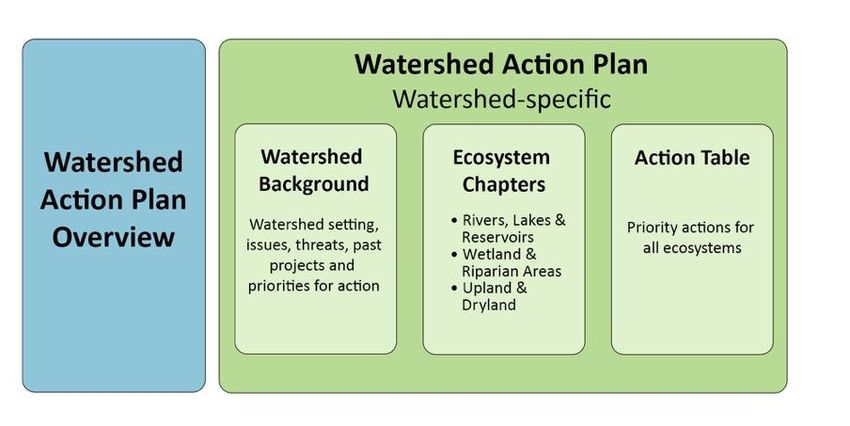
Watershed Background
SHUSWAP RIVER WATERSHED BACKGROUND
Introduction
The FWCP Action Plans provide strategic direction for each region based on the unique priorities, compensation
opportunities, and commitments in the region and they reflect FWCP’s vision and mission. The Action Plans describe the
strategies and Priority Actions to support FWCP objectives. Please refer to the Action Plan Overview for more
information on the process that was followed to develop Action Plans. The structure of this Action Plan is shown in
Figure 1.
Figure 1: Structure of FWCP Action Plan Overview and Action Plan components.
Setting
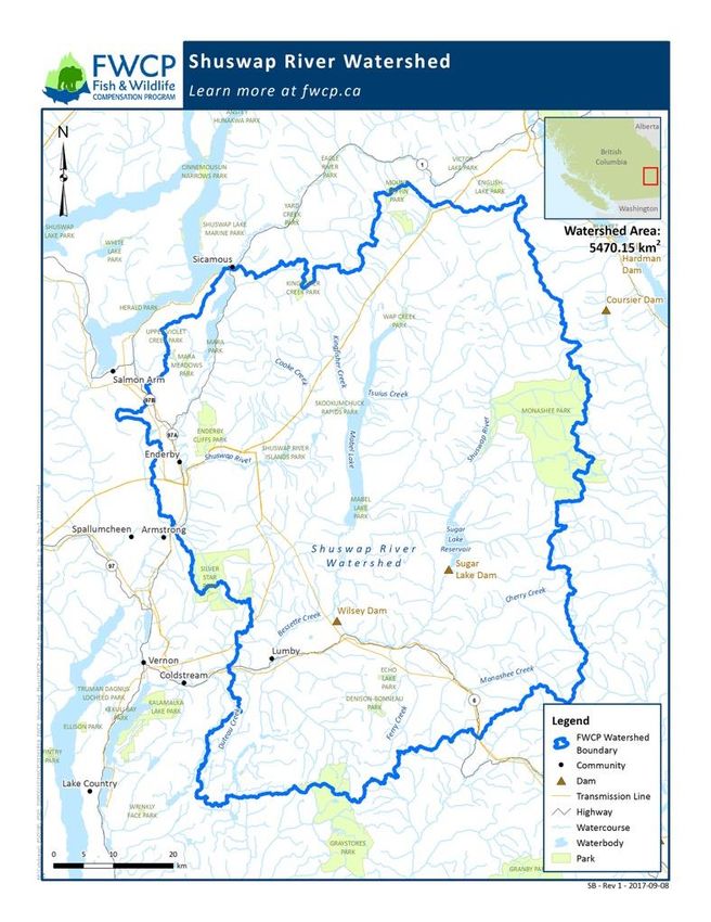
The middle Shuswap River is located upstream of Shuswap Falls in the dry interior of British Columbia, near the town of
Lumby ( Figure 2). The basin area above Shuswap Falls is 1969 km 2, with elevations ranging from 450
m to 2680 m. The Shuswap River basin is climatically within the southern interior region of BC, which is affected by both
continental and modified maritime conditions. Temperatures are also affected by continental air from the south (warm)
and from the north (cold). Runoff is dominated by snow melt from the surrounding mountains. The November to
January period has the highest precipitation, with an average of 120 mm/month, and as much as 250 mm/month (BC
Hydro 2005).
The Shuswap River project was completed in 1929 by West Canadian Hydroelectric Corporation. The project consists of
two dams, Sugar Lake Dam, which impounds the Sugar Lake Reservoir, and Wilsey Dam at Shuswap Falls. The dams are
separated by 31 km and power is generated only at Wilsey Dam. The Wilsey project is run-of-river, with very little
storage.
Both the Secwepemc and Okanagan Nations have stated interests in the Shuswap River Watershed. The Provincial
Consultative Areas Database system can provide a list of communities within these two Nations as well as contact
information for these communities (see Note). 1
1
Note: by identifying those Nations in the Shuswap River Watershed as determined by the Provincial Consultative Areas
Database system, FWCP is not making a determination on title and rights or the interests of any First Nations. FWCP’s
understanding is that the Provincial Consultative Area Database is not intended to create, recognize, limit or deny any
aboriginal rights, including title, that First Nations may have. No information provided by FWCP shall be used to
prejudice any claims stated by the interested First Nations.
6 Shuswap River Action Plan
Watershed Background

The watershed has a diverse group of users. Communities within the watershed include Cherryville, Lumby, Enderby,
Kingfisher, Ashton Creek, Splatsín Indian Band Reserve Lands, Grindrod and Mara. There is a small year-round
community that resides on Sugar Lake, which grows dramatically during the summer. There are several provincial parks
(e.g., Greenbush Lake, Monashee, Echo Lake, Dennis-Bonneau, Graystokes, Silver Star, Mabel Lake, Skookumchuck
Rapids, Shuswap River Islands, Enderby Cliffs, Upper Violet Creek, Wap Creek) and ecological reserves (e.g., Upper
Shuswap River, Vance Creek, Mara Meadows, Kingfisher Creek) in the watershed. The area is a very popular recreational
area; activities in the watershed include camping, hiking, biking, skiing, boating, fishing, horseback riding, snowmobiling,
hunting, canoeing, and kayaking.

                       Figure 2: The FWCP Shuswap River Watershed boundary.

Land Ownership in the Shuswap River Watershed
Land ownership in the Shuswap River Watershed is a mix of private and Crown lands. The valley bottoms are almost
exclusively privately owned with little Crown land. BC Hydro has large land holdings in the Middle Shuswap including

                                                                 7                                 Shuswap River Action Plan
Watershed Background
most of the edges of either side of the river Forest harvesting is extensive and includes logging of Crown land by large
companies, individual woodlot managers and community forest license holders as well as logging of private land. A
Biodiversity Conservation Analysis for North and Central Okanagan Region (Okanagan Collaborative Conservation
Program, 2013) is a possible resource for land ownership mapping. Proponents need to ensure proposed activities and
access requirements do not conflict with local land ownership and, where necessary, provide the status of project/land
owner discussions in the proposal.
Footprint Impacts and Threats
Dam construction, hydropower development, and alterations in the hydrologic regime of the system have resulted in
considerable changes to habitats and the fish and wildlife populations that rely on them. These impacts extend both
upstream and downstream of Wilsey Dam into the watershed. In the case of wildlife species, impacts can extend
beyond the Shuswap River watershed.
Hydro-related Impacts
Inundation: Reservoir impoundment from Sugar Lake Dam expanded the existing Sugar Lake from 1,564 ha to 2,217 ha,
flooding a spawning area at Sugar Lake outlet and 653 ha of riparian and upland habitat. Sugar Lake Dam also flooded 7
km of mainstem and 4 km of tributary channels, as well as their associated riparian areas. The Wilsey Dam headpond
flooded about 1 km of mainstem Shuswap River habitat.
Habitat Loss: The impoundment of Sugar Lake flooded 23 km of shoreline, 653 ha of grasslands and woodlands, as well
as 7 km of mainstem (65 ha of channel habitat) and 4 km of tributary and riparian areas. Dams have stopped or reduced
downstream gravel recruitment, potentially reducing available spawning habitat. A small reduction in large woody
debris for rearing habitat has occurred at the outlet of Sugar Lake where the debris boom captures lake drift logs. Large
Woody Debris downstream of Sugar Lake remains similar to pre-dam construction levels and the spillway weir at Wilsey
Dam allows large woody debris to pass downstream to Mable Lake. Sand deposition in the headpond may have
improved spawning habitat downstream of the dam, but may have trapped and reduced nutrient sources (nitrogen and
phosphorous). Migration barriers (described below) have prevented historic access for some species to 31 km of
Shuswap River mainstem and additional tributary habitat. Habitat upstream of the Sugar Lake Dam may have also been
accessible to some fish species prior to installation of the Sugar Lake Dam.
Migration Barriers: Historically, Shuswap Falls was a partial or complete upstream barrier to chinook, coho, sockeye and
non-anadromous resident fish species. A further 31km upstream, Brenda Falls, near the outlet of Sugar Lake, also
blocked upstream passage to Sugar Lake for resident river species and possibly anadromous species.
Wilsey Dam, at the Shuswap Falls location, blocks all upstream fish passage. The Sugar Lake Dam at the Brenda Falls
location blocks all upstream fish passage from the river above the dam to Sugar Lake.
New Habitat: There was a gain of 653 ha of reservoir habitat; however, the littoral area is less productive due to
fluctuating reservoir levels.
Nutrient Loss: Productivity has declined below Sugar Lake as dam blocks salmon carcasses from being washed into the
river.
8 Shuswap River Action PlanWatershed Background
Diversions: Diversion to the powerhouse dewaters 190 m of stream channel immediately downstream of Wilsey Dam
Water not used for power generation is diverted over the spillway weir to a rocky channel/canyon area, rejoining the
original channel near the base of the original Shuswap Falls. Fluctuating Reservoir: The Sugar Lake reservoir annual fluctuation
is approximately 7 m, reducing littoral productivity. The shoreline was expanded from 25 km to 39 km.
Altered Flow Regime: Rapid flow alterations may affect benthic insect populations, potentially strand fish, and dewater
eggs. However, dam operational efforts, and installation of an Environmental Bypass Valve have reduced incidence of
rapid flow alterations.
Entrainment: The magnitude of entrainment at Sugar Lake Dam and Wilsey Dam is unknown.
Non-hydro Impacts
Other impacts in the Shuswap River watershed include historic effects of fish harvest, logging, public access, farming,
cattle grazing, and road construction. The slides in the Fraser River at Hells Gate in 1913 and 1914 negatively affected
anadromous fish passage into the Shuswap River Watershed. Fish passage at Hells Gate was established in 1945 and
extended in 1956; however, fish stocks took a long time to recover.
Objectives for the Shuswap River Watershed
Clear management objectives are needed to guide information gathering and effective prioritizing of management
actions. Each Ecosystem Chapter has three objectives, which are high-level statements of desired future conditions
(outcomes), consistent with FWCP strategic objectives, partner mandates and policies. Each Ecosystem Chapter also has
more detailed sub-objectives, which provide more specific direction on desired future conditions. Priority Actions in the
Action Table align with the objectives and sub-objectives, summarized in Table 1.
Table 1: Summary of objectives and sub-objectives in each Ecosystem Chapter.
Sub-objectives
Objectives
Rivers, Lakes & Reservoirs Wetland & Riparian Areas Upland & Dryland
Conserve and restore habitat Protect, enhance and create Protect and enhance rare and
Ensure a productive and
capacity and diversity for fish new wetland and riparian ecologically significant
diverse ecosystem
and other aquatic organisms. habitat. upland/dryland habitat.
Maintain and, where feasible, Maintain and, where feasible,
Sustain and increase the increase the abundance of increase the abundance of
population viability of: (a) species of interest (e.g., species of interest (e.g.,
Anadromous salmon (Coho, federally listed species-at-risk federally listed species-at-risk
Maintain or improve the
Chinook, and Sockeye); and, and species identified through and species identified through
status of species of interest
(b) Resident salmonids government, community, and government, community, and
(Rainbow, Cutthroat, and Bull First Nations engagement). First Nations engagement).
Trout). See Action Table for specific See Action Table for specific
species. species.
Maintain or improve
Maintain or improve opportunities for sustainable use, including for food, social, ceremonial,
opportunities for sustainable
recreational, or commercial purposes.
use
9 Shuswap River Action PlanWatershed Background
FWCP Projects Implemented: Shuswap River Watershed
FWCP has been funding projects in the Shuswap River Watershed since 1999 under the Bridge-Coastal Restoration
Program (BCRP) and subsequently under the Fish & Wildlife Compensation Program 2 Coastal Region. A full list of the
reports from projects undertaken to date is available online at www.fwcp.ca. Below is a brief summary of the work
undertaken during the 2010/2011 to 2015/2016 FWCP project years.
Rivers, Lakes & Reservoirs
Eight Rivers, Lakes & Reservoirs projects were undertaken in the Shuswap River watershed during the 2010/2011 to
2015/2016 FWCP project years with $478,325 of FWCP funding. Of these, four projects were associated with the
research and information acquisition action of assessing viability of fish passage at Wilsey Dam (priority 1), which would
add approximately 32 km of mainstem Chinook, Coho and Sockeye salmon habitat in the Middle Shuswap River above
Wilsey Dam. Additional high quality habitat would be accessible in the tributaries upstream of Wilsey Dam. In 2012, one
of these projects assessed spawning habitat quantity and quality for primarily Chinook and Coho below versus above
Wilsey Dam and estimated that there is roughly double the spawning habitat above the dam compared to below. In
2013, the Okanagan Nation Alliance produced a detailed environmental feasibility assessment for re-establishing fish
passage above Wilsey Dam, including assessments of habitat capacity and potential impacts. This work concluded that
there are no serious impediments to re-establishing fish passage above Wilsey Dam and that planning should proceed.
Entrainment and mortality of juveniles at Wilsey Dam was identified as one of the primary data gaps, which has begun
to be addressed with two projects from 2014 to 2016 that assessed feasibility to monitor entrainment and juvenile
passage at Wilsey Dam. This work showed that it is possible to configure equipment to definitively quantify fish passage
routes through the dam and over the spillway weir.
The four remaining projects were habitat-based actions downstream of Wilsey Dam conducted through the Whitevalley
Community Resource Centre, and received $294,320 of FWCP funding. Three of these projects were phases of a multi-
year effort to restore Bessette Creek for Coho, Chinook and Rainbow Trout, including creation of a more stable channel
with continuous flow and deep pool habitat, increased habitat complexing, bank stabilization and riparian plantings. The
final project was completed in 2014-2015 and addressed river migration and erosion that was affecting 1500 m of the
Lower Shuswap River including damages to the Maltman side channels. Habitat complexing, pool creation, and side
channel protection activities sustain and restore important spawning and rearing habitats for Coho and other salmonids
in the Middle Shuswap River.
Wetland & Riparian Areas
One Wetland & Riparian Areas project was undertaken during the 2010/2011 to 2015/2016 FWCP project years with
$63,049 of FWCP funding. This project conducted Terrestrial Ecosystem Mapping as a base for a Sensitive Ecosystem
Inventory of Riparian/Wetland and Upland/Dryland habitat. Habitat suitability was also mapped for several
Riparian/Wetland species including the high priority Western Toad, Western Painted Turtle, and Western Screech-owl.
Upland & Dryland
Four Upland & Dryland projects were undertaken during the 2010/2011 to 2015/2016 FWCP project years with a total of
$141,385 of FWCP funding. One of these was the same as that which conducted Terrestrial Ecosystem Mapping for
Riparian/Wetland species and habitat; it also mapped Upland/Dryland habitat (e.g., grasslands, coniferous woodlands)
2 The Program changed its name in 2011 from the BCRP to the FWCP.
10 Shuswap River Action PlanWatershed Background
and conducted habitat suitability modelling for Upland/Dryland species of conservation concern (American Badger,
Flammulated Owl, Northern Rubber Boa, and Western Skink). Two of the projects (2013, 2014) targeted Bobolink, a high
priority Upland/Dryland species, through inventory and engagement with landowners to encourage beneficial changes
in farming practices. The third project (2016) conducted a survey of the South Monashee Caribou population (medium
priority).
Interactions with Other Ongoing Processes
Water Use Plan (WUP) – BC Hydro undertook Water Use Planning in the Shuswap River Watershed to find a better
balance of power and non-power interests (such as fish, wildlife and recreation) when operating the system. The
resulting WUP Order directed incremental operational changes and monitoring studies to determine the effectiveness of
the operational changes. FWCP partners support and coordinate with the WUP ordered monitoring studies, however
FWCP does not fund the monitoring associated with operations.
Fish Passage Decision Framework – Any studies to assess the feasibility of restoring fish passage at existing BC Hydro
facilities must adhere to the Fish Passage Decision Framework (BC Hydro 2016) to be funded by the FWCP.
Fish Entrainment Strategy – Fish entrainment issues are addressed through BC Hydro’s Fish Entrainment Strategy (BC
Hydro 2006). Grant applications to study or mitigate entrainment issues are not eligible for FWCP funding.
11 Shuswap River Action PlanEcosystem Chapters
ECOSYSTEM CHAPTERS
SHUSWAP RIVER WATERSHED
12 Shuswap River Action PlanEcosystem Chapter: Rivers, Lakes & Reservoirs
ECOSYSTEM CHAPTER: RIVERS, LAKES & RESERVOIRS
Actions for Rivers, Lakes & Reservoirs
The Action Table in this document (see page 22) identifies our Priority Actions to conserve and enhance fish & wildlife in
this watershed. Priority Actions are organized by Action type: Research and Information Acquisition, Habitat‐based
Actions, Species‐based Actions, Land Securement and Monitoring and Evaluation. Actions are assigned a priority ranking
from 1 (highest priority) to 3 (lowest priority).
Aquatic Habitat in the Shuswap River Watershed
The Middle Shuswap River flows southwest out of Sugar Lake to Cherryville and Lumby, and then flows north into Mabel
Lake. The Middle Shuswap River is an important Chinook and Coho Salmon producer in the region and also supports a
late-run Sockeye Salmon population and resident fish species including Kokanee, Rainbow Trout, Bull Trout and
Mountain Whitefish (Fraser Basin Council 2016).
Anadromous runs of salmon had access to the Middle Shuswap River, though there is some uncertainty about how far
upstream each species migrated. Shuswap Falls, at the current site of Wilsey Dam, acted as a partial barrier to upstream
movement. Chinook, Coho and Sockeye Salmon likely migrated upstream of the falls, though their run size is unknown.
Brenda Falls, at the current site of Sugar Lake Dam, was about 3 m high and may have been passable, although there is
no clear documented evidence of historic anadromous fish in Sugar Lake (Bengeyfield et al. 2001). High quality spawning
and rearing areas occur between Shuswap Falls and Brenda Falls (McGrath et al. 2014). Water temperatures above
Wilsey Dam are cooler and the river is generally less modified by human activities. Abundant natural side channels also
exist, which provide salmonid rearing habitat. Overall spawning habitat is approximately 1.5 to 2 times greater above
Wilsey Dam than downstream of the dam for Chinook and Coho Salmon combined.
Interior Fraser salmon stocks were substantially affected by two large slides in 1913 and 1914 at Hells Gate in the Fraser
Canyon, which created a barrier to upstream fish migration. Fishways built in 1945 and extended in 1956 improved fish
passage, but stocks took many years to rebuild. The effects of the Hells Gate slides is thought to have contributed to
underestimating the productivity of some fish stocks during evaluation of hydro-development in the watersheds.
Rainbow Trout and Kokanee are important resident salmonids in the Middle Shuswap. Both species are targeted by
anglers in the area, and Kokanee are also a significant prey species for other fish. Bull Trout/Dolly Varden and Mountain
Whitefish are present in the Middle Shuswap River and tributaries. Other fish species recorded in the watershed include
Cutthroat Trout, Burbot, Largescale Sucker, Longnose Sucker, Bridgelip Sucker, Northern Pikeminnow, Peamouth Chub,
Redside Shiner, Prickly Sculpin, Slimy Sculpin, and Longnose Dace.
Limiting Factors
Limiting factors vary among species and need to be further assessed. They are expected to include:
• Habitat area: Former spawning, rearing and overwintering areas are permanently lost by dam footprint,
reservoir drawdown and flooding, diversions, or dam and generating station operations; or from non-hydro
sources. Limited spawning habitat is likely the most important factor affecting the productivity for Chinook and
Sockeye Salmon in the system; while rearing habitat appears limiting for Rainbow Trout.
• Habitat quality: Physical habitat below dams is altered by reduced recruitment of gravel. Bank erosion and lack
of riparian vegetation is also a concern in some areas, and affects habitat through sedimentation. Some
tributaries are also affected by low flows, which can be exacerbated by water withdrawals for agriculture.
13 Shuswap River Action PlanEcosystem Chapter: Rivers, Lakes & Reservoirs
• Access: Wilsey Dam blocks access to formerly useable habitat above Shuswap Falls for Chinook, Sockeye and
Coho Salmon. It is possible that Sugar Lake Dam also blocked anadromous access to Sugar Lake and the upper
Shuswap. However, current evidence suggests that there was no anadromous access past Brenda falls. Altered
flow regimes affect passage conditions in some locations downstream of dams.
• Low nutrient load: River productivity may have reduced from historic levels due to a loss of marine derived
nutrients in the form of fish (specifically chinook) carcasses in the reaches between Sugar Lake Dam and Wilsey
Dam.
Knowledge Status
Habitat
A detailed account of habitat impacts from hydropower development is provided in BCRP (2000) and is summarized on
page 8. In addition to present and historic hydropower impacts there are diverse impacts in the watershed from
agriculture, forestry and linear development. For example, land clearing associated with agriculture affects stream
habitat by decreasing streambank stability, increasing erosion, changing temperature regimes, and altering nutrient
dynamics (Fraser Basin Council 2016).
Changes in operations agreed to by BC Hydro as a part the Water Use Plan (BC Hydro 2005) have likely improved habitat
conditions downstream of Sugar Lake and Wilsey dams. The WUP is expected to optimize the use of water for the
benefit of fish, including optimizing the availability of spawning and rearing habitat for resident and anadromous fish
species, and minimizing negative impacts associated with plant outages below Wilsey Dam.
Since 2000 many restoration projects have been undertaken by FWCP and community partners such as the Whitevalley
Community Resource Centre and over 1 million dollars has been invested in enhancing fish and wildlife in the area.
Habitat has been created in Duteau Creek smolt pond (2002, and upgraded in 2009), Proctor Channel (2003), Ireland
Creek side channel (2003) and Maltman off-channel pond (2005). Slope stabilization of the Huwer Bank was conducted
in 2007 to reduce erosion and sedimentation in the downstream areas. Fish habitat has been further enhanced through
the provision of groundwater in low flow periods from the Huwer aquifer complex (2006). More recently, side channel
restoration work has also been conducted in Lower Creighton Creek and the Maltman side channels, and stream
complexing, bank stabilization and riparian plantings have been completed in Bessette Creek. Inventory and mapping of
aquatic habitat in the Lower Shuswap River has been completed for the Regional District North Okanagan, City of
Enderby and DFO (Ecoscape 2011).
Knowledge Gaps
The following knowledge gaps have been highlighted by agencies, First Nations and stakeholders:
• To help set priorities for restoration, the program needs a better understanding of limiting factors that can be
addressed by restoration initiatives
• Understanding the effects of previous restoration efforts and a need to develop detailed restoration plans to
achieve long-term salmon conservation objectives
• There are various knowledge gaps with respect to supporting anadromous fish passage past Wilsey Dam. Work
should build upon that conducted in the "Environmental Feasibility of Establishing Fish Passage at Wilsey Dam"
(13.SHU.01) and "Developing a fish passage plan at Wilsey Dam" (COA-F18-F-2412). One continued uncertainty
is the extent of entrainment mortality.
14 Shuswap River Action PlanEcosystem Chapter: Rivers, Lakes & Reservoirs
• Developing a water management strategy for the Middle Shuswap is a priority. Uncertainties include
opportunities to support rearing of Coho Salmon with groundwater, water management in Besette and Duteau
creeks, and habitat constraints during low flow periods.
• Success of previous habitat-based actions undertaken by FWCP and partners.
Objectives and Measures
The following objectives have been developed to define the scope of the Rivers, Lakes & Reservoirs Ecosystem Chapter.
While the objectives are expected to remain stable over time, the projects funded may evolve as management priorities
shift, or new information becomes available.
Objective 1: Ensure a productive and diverse aquatic ecosystem.
This objective addresses overall ecosystem integrity and productivity and directs compensation activities to develop
productive, useable aquatic habitats. Where cost-effective opportunities exist, compensation works will be aimed at
aiding multiple aquatic species to conserve and restore habitat capacity and diversity for fish and other aquatic
organisms.
Measures — Measures will be ecosystem- and project-specific.
Objective 2: Maintain or improve the status of species of interest
This objective is supported by two sub-objectives:
1. Sustain and increase the population viability of anadromous salmon and steelhead.
Measures – Measures will be species- and project-specific.
2. Sustain and increase the population viability of resident salmonids.
Measures – Measures will be species- and project-specific.
Objective 3: Maintain or improve opportunities for sustainable use.
This objective reflects the important sustainable use benefits that can be derived from healthy fish populations. Many
salmonid species are the focus of First Nations, commercial and recreational fisheries. Consequently, any actions aimed
at achieving the above objective also support this sustainable use objective.
Measures — There are no specific measures required at this time.
15 Shuswap River Action PlanEcosystem Chapter: Wetland & Riparian Areas
ECOSYSTEM CHAPTER: WETLAND & RIPARIAN AREAS
Actions for Wetland & Riparian Areas
The Action Table in this document (see page 22) identifies our Priority Actions to conserve and enhance fish & wildlife in
this watershed. Priority Actions are organized by Action type: Research and Information Acquisition, Habitat‐based
Actions, Species‐based Actions, Land Securement and Monitoring and Evaluation. Actions are assigned a priority ranking
from 1 (highest priority) to 3 (lowest priority).
Wetland and Riparian Areas in the Shuswap River Watershed
Wetland and riparian areas are the most diverse and biologically rich terrestrial ecosystems in BC and are considered
highly valuable from an ecological standpoint. Riparian areas are the areas bordering on streams, lakes, and wetlands
that link water to land. The blend of streambed, water, trees, shrubs and grasses directly influences and provides habitat
for fish and wildlife. The abundance, distribution and condition of wetland and riparian habitats may be limiting factors
for many species, especially amphibians, which depend upon them either for the majority of their lifecycles or for key
periods such as breeding. Riparian and wetland habitats are often critical in terms of maintaining function and structure
for natural systems, including helping to support trophic level functioning and genetic diversity, as well as providing key
ecological services such as erosion control, flood control, assimilation of nutrients and water purification. Furthermore,
many wetland and riparian species are the focus of sustainable use activities by First Nations and non-First Nations
people. Riparian and wetland areas are commonly inundated by impoundments or adversely affected by changes in
hydrological regimes that result from water management for power generation. Loss and alteration can significantly
affect the services provided by these ecosystems.
The FWCP uses three general categories of riparian and wetland areas for setting objectives (Table 2). These categories
define a general level of ecosystem functioning and require different management actions to maintain and improve
their condition.
Table 2: Categories of riparian and wetland habitats used by the FWCP.
Category Description
Largely intact ecosystems with natural disturbances sufficient to
Category 1 – Natural
maintain subclimax communities and processes characteristics of
riparian or wetland habitat
wetlands and riparian ecosystems.
Category 2 – Disclimax or Formerly natural wetland or riparian ecosystems that have lost most or
degraded wetland or all of their natural disturbance regime and are no longer functioning
riparian habitat, or creation effectively as wetland or riparian habitat. These areas are candidates
of habitat for restoration.
Category 3 – Restored or Ecosystems resulting from water impoundments, diversions or other
created riparian or wetland artificial disturbances that require active management to maintain
habitat productivity and function.
Limiting Factors
The limiting factors for wetland and riparian areas are predominantly related to extent of the available habitat,
connectivity and distribution of the habitat, and its productivity. Limiting factors need to be further assessed and are
expected to include:
16 Shuswap River Action PlanEcosystem Chapter: Wetland & Riparian Areas
• Extent: The contribution of riparian and wetland habitats to broader ecological function is predominantly
limited by the extent of the habitats on the land base. Habitats are lost through inundation and conversion to
other land uses.
• Distribution: Connectivity among riparian and wetland habitats, and between these habitats and other habitats
and features, are important for dispersal of plants and animals and for seasonal movements of some species.
Wetland and riparian habitats that are isolated will likely have decreased diversity compared to those which
experience a healthy connectivity between areas. Distribution is therefore related not only to the extent of
healthy riparian and wetland habitats, but also to adjacent land uses.
• Productivity: Even where riparian and wetland habitats are adequately represented and connected, there are
several factors that can affect their productivity:
o Hydrologic conditions such as water level variability and flow rates are among the most important
variables driving riparian and wetland habitat development, structure, functioning and persistence
(National Research Council 2001). Wetlands and riparian ecosystems require dynamic water regimes to
maintain their productivity, but managed systems can result in unnatural cycles of stability and de-
watering that can impair function or result in succession to different habitat types (e.g., forest,
mudflats).
o Stressors such as invasive species or disruptive human access can affect community structure and
function.
o Loss of specific habitat features can affect life requisites of specific species, e.g., dense nesting cover for
waterfowl, suitable tree cavities for nesting owls or waterfowl, basking sites to turtles.
o Poorly understood factors limit the productivity of created wetlands. These are generally thought to be
related to unnatural hydrologic regimes and soil conditions (e.g., Atkinson et al. 2010).
Knowledge Status
Habitat
Basin-wide trends in the abundance, distribution and productivity of riparian and wetland habitats have not been
completely compiled (other than direct BC Hydro footprint impacts) for the entire watershed, however, extensive
mapping has been done of the Middle Shuswap River. Much of the riparian forests of the Middle and Lower Shuswap
Rivers have been lost due to land clearing for agricultural development.
The area of inundation has not increased since dam construction, but the productivity of adjacent habitats has
continued to be affected, either directly or indirectly as a result of BC Hydro operations.
High priority habitats in the Shuswap River Watershed, including wetlands, riparian habitats and at-risk ecological
communities have also been identified by the provincial government and the Regional District of the North Okanagan. A
Shuswap River Watershed Sustainability Plan (Regional District of North Okanagan (2014) has been developed by the
Regional District of the North Okanagan Terrestrial Ecosystem Mapping (TEM) was completed for a 4,833 ha area within
1 km of the Shuswap River, showing several rare ecosystems that are important for a variety of wildlife species. The
most significant ecosystem is late-successional cottonwood riparian floodplain forests, both “old-forest” and “mature-
forest” IDFmw1/05 (CwFd - Dogwood; cottonwood floodplain). This ecosystem is essential habitat for Western Screech-
owls and is on the provincial “blue” list. Other rare ecosystems and seral stages are present include:
• mature-forest IDFmw1/04 (Fd - Pinegrass – Feathermoss; CF priority=2)
• mature-forest IDFmw1/01 (zonal: FdCw - Falsebox - Prince's pine; CF priority=2)
The importance in these riparian ecosystems is magnified by the existence of some later seral stages that are rare and
under-represented in protected areas in BC.
17 Shuswap River Action PlanEcosystem Chapter: Wetland & Riparian Areas
Knowledge Gaps
Past investments in the Shuswap River watershed have improved knowledge about various riparian-associated wildlife
species and ecosystems. An inventory and research project on interior Western Screech-owls (which led to the creation
of 2 Wildlife Habitat Areas for the species) and inventories of amphibians and large riparian-nesting birds (e.g., Ospreys,
Bald Eagles and Great Blue Herons) have been conducted. Habitat mapping in the Middle Shuswap River area has been
conducted.
Objectives and Measures
The following objectives have been developed to define the scope of the Wetland & Riparian Areas Ecosystem Chapter.
While the objectives are expected to remain stable over time, the projects funded may evolve as management priorities
shift, or as new information becomes available.
Objective 1: Ensure productive and diverse wetland and riparian ecosystems.
This objective addresses overall ecosystem integrity and directs compensation activities to maintain ecosystem
productivity by protecting, enhancing or creating new wetland and riparian habitat.
This objective is supported by three sub-objectives:
1. Secure remaining Category 1 riparian and wetland habitat.
Wetland and riparian areas can be heavily impacted by conversion to other lands uses, such as agriculture
development or forestry, amongst others. Securing remaining habitat to prevent loss is very important. Habitat
is considered secure if it is protected from conversion to other land use, for example by purchasing the land or
negotiating a covenant agreement.
Measures — Measures will be ecosystem- and project-specific.
2. Reduce threats to Category 1 riparian and wetland habitat.
Wetlands and riparian areas are subject to a variety of threats both internally and externally. Many naturally
functioning riparian and wetland habitats (Category 1) can benefit from management actions that reduce
specific threats (e.g., treatment for invasive species, access control, forestry in adjacent areas etc.).
Measures — Measures will be ecosystem- and project-specific.
3. Restore degraded or create new riparian and wetland habitat (Category 2).
While conservation of existing high quality habitat is always preferable, category 1 habitat may be limited or the
opportunities for conservation are difficult. Restoration opportunities may be more available in areas where
changes in water regime have altered successional pathways in pre-existing riparian and wetland ecosystems.
Typically the regime in managed watersheds becomes more stable. Riparian and wetland ecosystems require
the disturbances caused by fluctuating water levels to maintain their productivity. When these disturbances are
reduced or eliminated, riparian and wetland ecosystems transition to other ecosystem types. Projects can be
designed to restore the original ecological function of these areas, or to create new riparian or wetland habitats
that differ from what was present historically, but still represent an improvement in function.
Measures — Measures will be ecosystem- and project-specific.
18 Shuswap River Action PlanEcosystem Chapter: Wetland & Riparian Areas
Objective 2: Maintain or improve the status of species of interest.
Actions under this objective focus on addressing limiting factors that are not otherwise addressed by general
improvements to ecosystem function under Objective 1. The intent is to maintain, or where feasible, increase the
abundance of species of interest (e.g., federally listed species-at-risk or species identified through government, industry,
public and First Nations engagement).
Measures — Measures will be species- and project-specific.
Objective 3: Maintain or improve opportunities for sustainable use.
Many wetland and riparian species are the focus of sustainable use activities by First Nations and non-First Nations
people (e.g., duck hunting, medicinal plants, wildlife viewing). Actions addressing Objectives 1 and 2 will often support
this sustainable use objective.
Measures — Measures will be species- and project-specific.
19 Shuswap River Action PlanEcosystem Chapter: Upland & Dryland
ECOSYSTEM CHAPTER: UPLAND & DRYLAND
Actions for Upland and Dryland Areas
The Action Table in this document (see page 22) identifies our Priority Actions to conserve and enhance fish & wildlife in
this watershed. Priority Actions are organized by Action type: Research and Information Acquisition, Habitat‐based
Actions, Species‐based Actions, Land Securement and Monitoring and Evaluation. Actions are assigned a priority ranking
from 1 (highest priority) to 3 (lowest priority).
Upland and Dryland in the Shuswap River Watershed
Upland and dryland habitats are those that occur above areas of permanent inundation or periodic flooding. They are
usually the habitats least affected by hydroelectric generating infrastructure or operation; however, footprint impacts
have occurred and they contribute to the cumulative effects of human-related activities in these habitats.
Upland/dryland habitats are diverse and can range from unvegetated areas to grasslands, forests and alpine ecosystems.
Different habitats are associated with distinct species assemblages that react to direct or indirect stressors in their
distinct habitat niches.
The Shuswap River Watershed is large and ecologically diverse, spanning forested grasslands to alpine meadows (Lloyd
et al. 1990). Lower elevations are located in the Interior Douglas-fir (IDF) zone, while mid elevations are characteristic of
the Interior Cedar Hemlock (ICH) and Montane Spruce (MS) zones. High elevation forests are in the Engelmann Spruce
Subalpine Fir (ESSF), which transition to Interior Mountain Heather Alpine (IMA).
Limiting Factors
Limiting factors vary among species and need to be further assessed. They are generally associated with:
• Habitat loss and alteration: The cumulative effects of forestry and hydro-electric development have resulted in
substantial losses and alterations to habitat and habitat connectivity.
• Habitat connectivity: Habitat loss and road development have resulted in lost connectivity between habitats,
which alter wildlife movement.
Knowledge Status
Habitat
The Middle Shuswap portion (between Mabel Lake and Sugar Lake) of the Shuswap River watershed is unique
in that it has a hot and dry climate that is more characteristic of the nearby Okanagan Valley. As such it hosts a
wide array of amphibians, reptiles, birds, and mammals that are not found elsewhere within the watershed.
Knowledge Gaps
A comprehensive inventory of the species present in the in the larger Shuswap River watershed does not exist but
previous FWCP investments have conducted inventories for the Southern Monashee Caribou herd, bats, Bobolinks and
reptiles.
20 Shuswap River Action PlanEcosystem Chapter: Upland & Dryland
Objectives and Measures
The following objectives have been developed to define the scope of the Upland & Dryland Ecosystem Chapter. While
the objectives are expected to remain stable over time, the projects funded may evolve as management priorities shift,
or as new information becomes available.
Objective 1: Ensure productive and diverse upland and dryland ecosystems.
Actions under this objective are aimed at protecting/enhancing rare or ecologically significant features.
Measures — Measures will be ecosystem- and project-specific.
Objective 2: Maintain or improve the status of species of interest.
Actions under this objective focus on addressing limiting factors that are not otherwise addressed by general
improvements to ecosystem function under Objective 1. The intent is to maintain, or where feasible, increase the
abundance of species of interest (e.g., federally listed species-at-risk or species identified through government and First
Nations engagement).
Measures — Measures will be species- and project-specific.
Objective 3: Maintain or improve opportunities for sustainable use.
Upland and dryland habitats and associated species are also a focus of sustainable use activities by First Nations and
non-First Nations people (e.g., hunting, medicinal plant collection, wildlife viewing). Actions addressing Objectives 1 and
2 will often support this sustainable use objective.
Measures — Measures will be species- and project-specific.
21 Shuswap River Action PlanAction Table
ACTION TABLE
This Action Table identifies the FWCP’s Priority Actions to conserve and enhance fish and wildlife impacted by BC Hydro dams in this watershed. Actions
identified as OPEN (see Delivery Approach column) are eligible for a grant. When completing your online grant application, you will be required to identify a
Priority Action(s) that best aligns with your project idea. A high-quality grant application will clearly demonstrate alignment with Priority Action(s) in an Action
Table.
SHUSWAP RIVER WATERSHED ACTION TABLE Version: 20Aug18
Priority Action
Action Ecosystem Target Intended Delivery
Action Type Short Priority Priority Action Location
# Chapter Species Outcome Approach
Description
Develop a current habitat assessment map for priority fish and/or wildlife
species in the Shuswap watershed. Habitats to be assessed & mapped include:
• Wetlands
• Riparian Areas
• Stream Habitats
• Connectivity Corridors
• Forested Ecosystems (e.g., seral stage distribution)
• Over-wintering habitat for species that utilize talus, karst or rock features
(e.g., bats, snakes)
• Culturally Important Areas
Mapping is to include as much on-the-ground information as possible relevant
to the subject fish and/or wildlife species. The assessment should focus on Improved
SHU.ALL.RI.01.0 practical conservation and restoration opportunities. For fish, this work should strategic
Research and 1 Develop a inform development of habitat restoration and protection plans for priority planning for
Fish &
1 All Information current habitat 1 species and habitats. Consideration should be given to potential impacts from conservation Directed Throughout
Wildlife
Acquisition assessment available climate change predictions relevant to the specific habitats (i.e., and
map-P1 potential changes to vegetation communities, precipitation, wetland hydro- restoration
periods, snowpack, wildfire risk, wildlife movements, etc.). Project proponents opportunities.
should review "A Biodiversity Conservation Analysis for the North and Central
Okanagan Region" (Caslys Consulting Ltd. 2013, available at
), the Shuswap River Water Sustainability Plan
(http://www.rdno.ca/docs/141114_SRWSP_FinalFormat.pdf) and work
conducted through the Shuswap Watershed Mapping Project
(http://cmnbc.ca/atlas-group/shuswap-watershed-mapping-project). Mapping
on the Middle Shuswap should also build upon the "Middle Shuswap Sensitive
Ecosystem Inventory and Sensitive Habitat Inventory Mapping Project:
06.SHU.03". Particular areas of interest for BC Parks include Enderby Cliffs, and
the Mt. Griffin, Kingfisher and Mara Meadows Ecological Reserves.
Recommendations should be made through this work for future management
actions and assessments.
22 Shuswap River Action PlanAction Table
SHUSWAP RIVER WATERSHED ACTION TABLE Version: 20Aug18
Priority Action
Action Ecosystem Target Intended Delivery
Action Type Short Priority Priority Action Location
# Chapter Species Outcome Approach
Description
SHU.ALL.RI.02.0
1 Conduct a
limiting factors
analysis for
priority FISH- 1
Middle Shuswap Conduct a limiting factors analysis for priority fish and/or wildlife in the
River Shuswap watershed or sub-basins to support prioritization of future projects.
downstream of This will include an assessment of population status, habitat status or habitat
Wilsey Dam-P1 capacity and/or a cost-benefit analysis of any habitat-based actions proposed
SHU.ALL.RI.02.0 by the program, and should be considerate of the root causes of degraded
To determine
2 Conduct a habitats and limitations to productive potential.
cost-benefit
limiting factors of potential
2 analysis for 2 For fish, sub-basins for assessment include the Middle Shuswap River
FWCP actions
priority FISH- downstream of Wilsey Dam (Priority 1), Bessette Creek and tributaries (Priority
and support
Bessette Creek 2), the Middle Shuswap River and tributaries between Wilsey Dam and Sugar
prioritization
& tributaries-P2 Lake Dam (Priority 1), and the Upper Shuswap River including Sugar Lake and
of future
tributaries (Priority 2). For wildlife, sub-basins for assessment include the Upper
Research and SHU.ALL.RI.02.0 projects.
Fish & Shuswap River including Sugar Lake and tributaries (Priority 2), Middle Shuswap
All Information 3 Conduct a Leads to the Open Throughout
Wildlife River between Sugar Lake Dam and Wilsey Dam (Priority 1), Middle Shuswap
Acquisition limiting factors creation of
River between Wilsey Dam and Mabel Lake (Priority 2) and Lower Shuswap
analysis for robust habitat
(Mabel Lake and downstream; Priority 3). Analyses should build upon previous
priority FISH- or species-
1 and ongoing assessments, including the Water Use Plan studies and any existing
Mid.Shuswap based
restoration plans, in association with local agency, First Nation and BC Hydro
Riv&tributaries restoration
staff, private landowners and other land managers. Analyses for fish in the
betwn Wilsey plans for the
Middle Shuswap between Wilsey Dam and Sugar Lake Dam should build upon
Dam&Sugar Lk watershed or
work conducted in the "Environmental Feasibility of Establishing Fish Passage at
Dam-P1 sub-basins.
Wilsey Dam" (13.SHU.01) and "Developing a fish passage plan at Wilsey Dam"
SHU.ALL.RI.02.0 (COA-F18-F-2412).
4 Conduct a
limiting factors *Please note that the FWCP may develop templates for this work. Please check
analysis for with FWCP to see if these templates are available.
priority FISH- 2
Upper Shuswap
River incl.Sugar
Lk&tributaries-
P2
23 Shuswap River Action PlanYou can also read