SHEFFIELD CITY REGION TRANSPORT STRATEGY 2018 - 2040 - DRAFT FOR CONSULTATION - November 2017
←
→
Page content transcription
If your browser does not render page correctly, please read the page content below
SHEFFIELD
CITY REGION
TRANSPORT
STRATEGY
2018 - 2040
November 2017

DRAFT FOR CONSULTATION
CONTENTS

FOREWORD                                      05

EXECUTIVE SUMMARY                             07

MAIN REPORT                                   09
1.0   Introduction                            09

2.0   SCR to 2040 – The Evidence Base         13

3.0   Our Vision                              41

4.0   Our Goals                               43

5.0   Our Policies and Conditional Outcomes   45

6.0   Outline Implementation Plan             61
Sheffield City Region

4
Transport Strategy 2018 - 2040

FOREWORD

We are pleased to present the Sheffield City Region Transport Strategy 2018 – 2040.
Transport has an impact on everybody’s life and is central to us achieving our
ambitions for economic growth, guided by our Inclusive Industrial Strategy. This
strategy defines our vision for the future – that by 2040 we will continue to be a
forward-looking City Region with integrated transport connections that support
economic growth and improve quality of life for all. To realise our vision this strategy
defines the goals we must achieve, the policies we will adopt to do this, and the
conditional outcomes by which we will measure our success.

This strategy is part of the Fourth Local Transport Plan for South Yorkshire, in
conjunction with an Implementation Plan which will be produced subsequently and
which will explain how the strategic priorities identified here will be delivered. In
producing this strategy we have drawn extensively on the 2011 Sheffield City Region
Transport Strategy, refreshing it to reflect the changes that have transpired since it
was published; greater devolution of powers and creation of the Sheffield City Region
Combined Authority; establishment of Transport for the North; progress on delivering
national infrastructure programmes; and our own successes in implementing
transport improvements across Sheffield City Region.

People’s travel patterns do not always match the administrative boundaries between
South Yorkshire and its adjacent counties. We have therefore developed this strategy
across the economic geography of Sheffield City Region, which reflects the travel to
work area for Sheffield and its neighbouring towns. Sheffield City Region includes the
whole of South Yorkshire, and also parts of Derbyshire and Nottinghamshire, including
the Peak District National Park.

As the Local Transport Body for South Yorkshire, the Sheffield City Region Combined
Authority has worked in collaboration with authorities across the Sheffield City
Region to create this strategy. The Local Enterprise Partnership for the Sheffield City
Region has a key role in developing our policies to support the area’s prosperity and
economic growth, which are at the heart of this strategy, and which we have reflected
in its development.

In preparing this strategy we have consulted with business groups, local authority
partners, national infrastructure providers, the health sector, universities and
transport operators. We have sought to strike the right balance between encouraging
investment and increasing productivity, whilst at the same time increasing economic
inclusion and access to employment, creating healthy streets where people feel safe,
enhancing our environment, and embracing new technologies and ways of doing
things. Following the twelve-week public consultation period we will also incorporate
feedback received from wider stakeholders and the general public.

This is a long term strategy for a forward-looking City Region. It clearly sets out our
priorities and ambition within a flexible framework which will prove resilient over time
– allowing us to plan for the future with confidence.

                                                                                                                       5
Sheffield City Region

6
Transport Strategy 2018 - 2040

EXECUTIVE SUMMARY

INTRODUCTION
This Sheffield City Region (SCR) Transport Strategy sets out the transport priorities for
our City Region up to 2040.

This Transport Strategy updates and supersedes the policies and measures of our
previous Transport Strategy, published in 2011. It forms part of our Local Transport Plan
(LTP) and is adopted by the SCR Combined Authority, as the Local Transport Body for
South Yorkshire.

OUR VISION
 WE WILL CONTINUE TO BE A FORWARD-LOOKING CITY REGION WITH INTEGRATED
 TRANSPORT CONNECTIONS THAT SUPPORT ECONOMIC GROWTH AND IMPROVE
 QUALITY OF LIFE FOR ALL

OUR GOALS

                                                                                                                        7
Sheffield City Region

    Goal                                   Policy                              Conditional Outcome (by 2040)
                                           1. Improve access to                a. Increase GVA by £500m through increasing
                                              jobs, markets, skills               the number of economically active people
                                              and supply chains                   living within 30 minutes of key employment
                                           2. Enhance productivity                locations and universities by public transport
                                              by making our transport          b. Increase rail commuter flows with Greater
                                              system faster, more reliable        Manchester and Leeds City Regions by 4,950
                                              and more resilient                  incoming & 7,400 outgoing residents
                                           3. Invest in integrated             c. 90% of our population located within 1.5
                                              packages of infrastructure          hour journey time by public transport of an
                                              to unlock growth and                international airport that offers long-haul flights
                                              support Local Plans              d. Increase productivity by £500m through
                                                                                  reducing delays on our transport network
                                                                               e. 70% of people living in the most deprived
                                                                                  areas are brought within a 30 minute
                                                                                  journey time by public transport of an
                                                                                  urban centre, growth area or university
                                           4. Make our streets healthy         f. Achieve mode share targets of 47%
                                              places where people feel safe       private car, 33% public transport,
                                           5. Enhance our multi-modal             9% walking and 11% cycling
                                              transport system which           g. 95% public opinion that our local
                                              encourages sustainable              transport choices feel safe
                                              travel choices and is            h. Reduction of reported casualty rate of
                                              embedded in the assessment          6% pedestrians, 3% cycles, 3% private
                                              of transport requirements           transport and 7% public transport
                                              for new development,
                                              particularly for active travel
                                           6. Improve sustainable and
                                              inclusive access to our green
                                              and recreational spaces
                                           7. Actively improve air             i. Eliminate AQMAs in our City Region
                                              quality, especially in           j. Reduce tailpipe carbon emissions in line
                                              designated AQMAs                    with targets for the UK and have a zero
                                           8. Deliver a low carbon                carbon public transport network by 2040
                                              transport network,               k. Increase footfall in the main retail and leisure
                                              including a zero carbon             areas within our urban centres by 15%
                                              public transport network            through improvements to our public realm
                                           9. Work in tandem with
                                              the planning and
                                              development community
                                              to create attractive places

                                           10. Be at the forefront of          l. £330m cumulative additional transport-
                                               transport innovation               focussed research and development
                                           11. Enable different solutions to      investment within our City Region
                                               create a fully integrated and   m. Increase productivity by £75m
                                               inclusive transport service        through technology based efficiencies
                                           12. Adopt technology solutions         and reduced journey times
                                               to stimulate change

Table 5.1 - Our transport policies and conditional outcomes

8
Transport Strategy 2018 - 2040

1.0 INTRODUCTION

1.1       PURPOSE OF OUR TRANSPORT STRATEGY
This SCR Transport Strategy sets out the transport priorities for our City Region up to
2040.

This Transport Strategy updates and supersedes the policies and measures of our
previous Transport Strategy, published in 2011. It forms part of our Local Transport Plan
(LTP) and is adopted by the SCR Combined Authority, as the Local Transport Body for
South Yorkshire.

This Transport Strategy is accompanied by an Integrated Assessment and Habitats
Regulations Assessment.

1.2       REFRESH OF OUR TRANSPORT STRATEGY
Our existing Transport Strategy was published in 2011, and describes the transport
priorities for our City Region for the 15 year period up to 2026. Since then, we have
made a devolution deal with Government and have worked hard to develop the
SCR Inclusive Industrial Strategy, which is our strategic plan for economic growth
to 2040. In light of this development in our regional policy, it is necessary to refresh
our Transport Strategy so that it aligns with, and supports our Inclusive Industrial
Strategy, as well as the following wider policy and strategy drivers:
-- Transport for the North has now been established to speak with
   one voice for the North on Pan-Northern Transport requirements
   and has a Strategic Transport Plan for the North.
-- Highways England has changed its operational status
   and updated its Road Investment Strategy.
-- Local Plans have moved on in the last seven years and
   the Transport Strategy needs to catch-up.
Furthermore, the rate of technological change over the last decade has been
unprecedented, which means that our opportunities, challenges and possible
solutions have changed. This refresh of the Transport Strategy will make us more
prepared and better able to achieve our regional ambitions in a coordinated and
coherent manner.

                                                                                                                        9
Sheffield City Region

                                       2017            2018         2019           2020      2021           2022         2023         2024          2025        2026         2027           2028         2029           2030+
                                                         TfN to become sub-national
                                                                transport body
       Transport for the North
                                    First Draft Strategic         Adopted Strategic
                                       Transport Plan               Transport Plan
             Rail North             Long-term Rail Strategy
         High Level Output                                                                                         HLOS 4
         Statements - DfT
                                              HLOS 3                                                                                                                                 HLOS 5

                                            Control Period 5                                    Control Period 6                                                  Control Period 7
  Control Periods and LongTerm
  Planning Process - Network Rail            Route Studies

                                                                                     New Northern Franchise                                                                          New Franchise Period

                                                                           TransPennine Express Franchise                                                                   New Franchise Period

           Rail Franchising                Cross Country Franchise                                                                         New Franchise Period

                                                                         East Coast Franchise                                                                       New Franchise Periods

                                      West Coast Franchise                                                                          New Franchise Periods

                                    East Midlands Franchise                                                                         New Franchise Periods

                                                                                                                                                                       Phase 1, to become operational in 2026
                                     Hybrid Bill                                                                                                                                       Phase 2a, expected to be        Phase 2b, to
                HS2                                                                                                                                                                                                    be delivered
                                    for phase 2                                                                                                                                           delivered by 2027              by 2033

                                         Road Investment Strategy 1                                    Road Investment Strategy 2                                            Road Investment Strategy 3...4...
     Road Investigation Strategy
                                       Strategic Studies, Strategic Road                                             Strategic Studies, Strategic                                       Strategic Studies, Strategic
                                             Network Initial Report                                                  Road Network Initial Report                                        Road Network Initial Report
                                                                                                                                                                                                                         Future
       National Election Cycle                                Current Parliament                                   New Parliament following May 2022 election                          New Parliament                  Parliament

Figure 1.1 -Wider Strategy & Policy Drivers influencing this Transport Strategy Refresh

                                                                    The process of refreshing the Transport Strategy is shown in Figure 1.2. It builds on the
                                                                    previously agreed Transport Strategy and reflects changes to national, regional and
                                                                    local policy. It also reflects an update to the evidence base which describes how SCR
                                                                    has changed since 2011 and how we plan to continue to change in the future.

          National and                                              Evidence base review &
         Regional policy                                           Integrated Environmental
            changes                                                Assessment and Habitats
                                                                    Regulations Assessment

                                                                                                            Conditional
                                                                                                             outcomes

        Previous SCR                        Local                       Vision, Goals and                                                         Draft                       Public                                Final
     Transport Strategy                     policy                       Policies update                                                        strategy                    Consultation                          Strategy
                                           changes                                                                                               update

Figure 1.2 - Transport Strategy refresh process

10
Transport Strategy 2018 - 2040
1.3 THE ECONOMIC GEOGRAPHY OF OUR CITY REGION
The goals and policies of this strategy apply to South Yorkshire as part of its LTP. Our
economic geography is wider than South Yorkshire, and therefore, the measures of
success in this strategy cover the wider SCR, which functions as a coherent economic
area with strong economic linkages and travel to work patterns. Figure 1.3 shows
the South Yorkshire and SCR boundaries. The influence and benefits of this strategy
also extend further as part of the Northern Powerhouse and National Infrastructure
Programmes. The strategy includes interventions that will benefit the economies of
our neighbouring Combined Authority areas and UK plc.
South Yorkshire shares strategic links with its neighbouring counties and we recognise
that Local Authority districts are distinguished by boundaries but should not present
barriers to economic growth. Nottinghamshire County Council and Derbyshire County
Council are aware of this Strategy and our proposed goals and policies. We are
actively seeking their input through this consultation.
Nottinghamshire County Council and Derbyshire County Council also have their
own LTPs, and therefore there is a degree of geographical overlap between all three
regional LTPs. We will work in a coordinated way to bring forward schemes and
programmes that benefit businesses and communities, and seek opportunities to
strengthen linkages and jointly invest.
Barnsley Doncaster
Sheffield Rotherham
Bassetlaw
Bolsover
Chesterfield
N.E. Derbyshire
Derbyshire Dales
Northern
Powerhouse
Figure 1.3 - Sheffield City Region and South Yorkshire Districts
11Sheffield City Region
1.4 OUR TRANSPORT PROSPECTUS
In May 2017 we published our Transport Prospectus as the first stage of refreshing the
Transport Strategy. The purpose of the Prospectus is to:
-- highlight the fundamental role that transport will play
in delivering our plans for economic growth;
-- reaffirm our steadfast commitment to supporting national transport
infrastructure programmes that benefit our City Region;
-- confirm our ambitions for improved connectivity to the wider
North, as a core part of the Northern Powerhouse; and
-- set out priorities for improving our City Region’s transport
network through investment and devolution, building on
our successful Infrastructure Fund programme.
This Transport Strategy document builds on the priorities that are stated in the
Transport Prospectus and provides overarching goals, policies and conditional
outcomes for our transport system.
1.5 STRUCTURE OF THIS TRANSPORT STRATEGY
This Transport Strategy is structured as follows:
-- Chapter 2 provides the evidence base for the Strategy,
which is built upon existing data;
-- Chapter 3 sets out our vision for the future transport provision in our City Region;
-- Chapter 4 sets our goals;
-- Chapter 5 explains our policies and how we will seek to achieve them;
-- Chapter 6 describes how we will deliver our Transport Strategy.
12Transport Strategy 2018 - 2040
2.0 SCR TO 2040 – THE EVIDENCE BASE
2.1 INTRODUCTION
This evidence base provides the foundation for the Transport Strategy; it informs us
of the current challenges, opportunities, strengths and weaknesses in our City Region,
and how they may change in the future.
A significant amount of work has been undertaken since the 2011 Transport Strategy
through various studies. The Transport Strategy is informed by the comprehensive
evidence base gathered from various data sources such as national and regional
strategies set out by Highways England, Network Rail and Transport for the North,
our Local Plans, the SCR Inclusive Industrial Strategy and Integrated Infrastructure
Plan (SCRIIP), existing transport strategy evidence base and open source datasets as
illustrated in Figure 2.1 and identified in the subsequent sections. We have therefore
drawn this evidence base from these sources and have analysed global trends to
identify those which are likely to be important to our City Region to 2040.
CITY REGION
ts
g repor
torin ers
m oni akehold Loc
t al P
nd nd s
ies a rs a PAN-NORTHERN lan
s
ic rtn e
l
o a
, p p Pos ition Stateme
m T fN nts
fro a
t
Da
NATIONAL
es
as
Hi
ab
Inf
g
SC structu
Inv hw
dat
ra
e
R In
s
ay en
rce
al
st
s E t Str
os
m
tegraet Plan
Opensou
rop
ng
land
r
HS2 P
C o m m is sio n
ed
ategy
SOURCES
Road
GLOBAL
OF EVIDENCE
TRENDS
Inde pe
i v it y
nde
ect
nt
Evid
gy
nn
Ec
N il
ate
Co
Urb et w ork R a dy
enc
on
a n M arket Stu
Str
al
om
eb
c
on
Re ti
i
ial
na
as
vi er
str
ew
Int
ef
du
or
Tf N
In
11
ve
20
-2
02 si
6L clu
TP In
Strat
egic Economic Plan
Figure 2.1 - Evidence base
13Sheffield City Region
We have structured these trends under the ‘STEEP framework’, which is commonly
used to evaluate external factors and covers social, technological, economic,
environmental and political influences (Figure 2.2). Supporting economic growth is
our central objective, and therefore the Economy theme is structured first.
S SOCIAL
P T
POLITICAL TECHNOLOGICAL
E E
ENVIRONMENTAL ECONOMIC
Figure 2.2 - STEEP framework
2.2 ECONOMY
2.2.1 PEOPLE, JOBS AND PRODUCTIVITY
Our City Region is home to 1.8 million people, providing 842,000 jobs and an annual
Gross Value Added (GVA) of over £30bn; GVA is the measure of the value of goods
and services produced in an area. Figure 2.3 shows that our City Region is performing
well with the actual GVA growth ahead of the growth targets in our 2014 Strategic
Economic Plan (SEP). This has triggered a refresh of the SEP through the SCR Inclusive
Industrial Strategy to be proactive in setting more ambitious targets for economic
growth in our City Region.
44000
42000
40000
GVA, £m
38000
36000
34000
£3.1bn
32000
30000
13
14
15
16
17
18
19
20
21
22
23
24
25
26
27
28
29
30
20
20
20
20
20
20
20
20
20
20
20
20
20
20
20
20
20
20
Actual GVA growth Current SEP target
SCR average growth (last 5 years) SCR average growth (last 20 years) UK average growth (last 20 years)
Figure 2.3 - Actual GVA Growth in SCR vs. SEP target1
SCR Inclusive Industrial Strategy (Draft) (SCR Local Enterprise Partnership, 2017)
1
14Transport Strategy 2018 - 2040
Despite good recent performance in actual GVA growth, GVA per person remains
low relative to our peers and the wider UK (see Figure 2.4), and our City Region is
ranked 36th out of 39 LEP areas in England for GVA per person2. The GVA per head
of population in SCR in 2015 was £17,984 compared to £21,341 per head for Leeds
City Region (LCR) and £21,626 per head for Greater Manchester. We must focus
on increasing highly skilled jobs to meet the productivity levels of other LEPs. This
presents an economic challenge to match the right people with the right jobs, which
can be achieved through making our built-up areas denser and through improved
connectivity as people travel further to access specific employment and training
opportunities.
24000
22000
20000
GVA per head (£)
18000
16000
14000
12000
1997 1999 2001 2003 2005 2007 2009 2011 2013 2015
Sheffield City Region North Eastern LEP UK (ex London)
Liverpool City Region West Midlands
3
Figure 2.4 - GVA per head
Table A3: Nominal Gross Value Added per Head by Local Enterprise Partnership, (Office for National Statistics,1997-2015)
2
SCR Inclusive Industrial Strategy(Draft) (SCR Local Enterprise Partnership 2017)
3
15Sheffield City Region
2.2.2 HOUSING
Our population is forecast to grow by 11%4 between 2011 and 2039. However, Figure
2.5 shows that growth in housing is below target and despite there being a number
of contributing factors, transport infrastructure plays a significant role in terms of
unlocking new development sites. Predicted trends in housing and population growth
(Figure 2.6 and Figure 2.7) suggest that the average household size will reduce and
population growth will continue to be positive. Therefore, delivering more houses
remains a priority to support forecast growth, and to meet the demands of an ageing
population and the changes in the way we live.
70000
60000
Number of completed new dwellings
50000
40000
30000
20000
10000
0
17
18
19
20
21
22
23
24
3
4
5
6
-1
-1
-1
-1
20
20
20
20
20
20
20
20
12
13
14
15
20
20
20
20
New dwellings completed Curent SEP target
2011-12 2012-13 2013-14 2014-15 2015-16
Total number of 3,550 2,880 3,290 3,550 3,880
new dwellings
Figure 2.5 - Number of dwellings completed across SCR vs. SEP target3
Population projections - local authority based by single year of age (Office for National Statistics, 2011 - 2039)
4
16Transport Strategy 2018 - 2040
2.45
2.40
2.35
Average Household Size
2.30
2.25
2.20
2.15
2.10
2011 2014 2019 2024 2029 2034 2039
SCR England
Figure 2.6 - Average household size projection5
700 15.7% 18.0%
16.0%
600
14.0%
% Change between 2014 and 2039
500
Population in thousands
12.0%
400 10.0%
14.5% 3.2% 6.9%
300 8.0%
6.0%
200
10.4% 6.1% 5.6% 6.2% 6.7% 4.0%
100
2.0%
0 0.0%
es
ld
m
er
w
ld
er
ey
sh st
tla
ie
al
ha
fie
st
ov
by Ea
sl
ire
rf
D
ca
rn
se
er
ef
ls
te
er h
re
on
Bo
Ba
Sh
th
s
D ort
es
Ba
hi
Ro
D
Ch
N
s
by
er
2014 2039 % Change (2014-2039)
D
Figure 2.7 - Projected Population Growth between 2014 and 20396
Table 427: Change in average household size, local authority districts and England, 2014- 2039 (Department for Communities and Local Government, 2012)
5
Table 2: 2014-based Subnational Population Projections for Local Authorities and Higher Administrative Areas in England (Office for National Statistics, 2016)
6
17Sheffield City Region
2.2.3 AGEING POPULATION
Along with an overall growth in population, our City Region is forecast to experience
an ageing population; over the next 25 years the old age dependency ratio (people of
pensionable age per thousand people of working age) will increase by 19%7. Figure
2.8 shows that between 2014 and 2039 the number of children aged 0-5 is forecast
to remain constant in our City Region, but population aged 65+ will increase to 0.35
million. These demographic changes will have implications for transport as older
people tend to have different travel patterns and travel needs to younger generations,
such as travelling during off-peak periods for purposes other than work, and generally
being less digitally connected8.
Above 90
85-89
80-84
75-79
70-74
65-69
60-64
55-59
Age Group
50-54
45-49
40-44
35-39
30-34
25-29
20-24
15-19
10-14
5-9
0-4
60,000 40,000 20,000 0 20,000 40,000 60,000
Male Population-2014 Female Population-2014 Male Population-2039 Female Population-2039
Population
Figure 2.8 - Population pyramid for SCR 2014 and 2039 forecast comparison9
National Population Projections: 2014-based Statistical Bulletin (Office for National Statistics, 2016)
7
Communications Market Report (Ofcom, 2016)
8
Population projections - local authority based by single year of age (Office for National Statistics, 2016)
9
18Transport Strategy 2018 - 2040
Derbyshire Dales
2.2.4 URBANISATION Bolsover 4%
North East Derbyshire 4%
Figure 2.9 shows the population and employment distribution across our City Region.
75% of our residents live in the four main urban areas of Sheffield, Doncaster,5%
Rotherham and Barnsley. Between 2001 and 2011, the population of each of these
Chesterfield
urban areas grew by more than 10,000 people, except Rotherham10. Although the
6% Sheffield
spatial distribution of employment shows a similar pattern to population, Figure 2.10
shows that in reality people travel throughout our City Region to access jobs, and this
31%
Bassetlaw
puts pressure on the existing transport system.
6% SCR
Population Share
Analysis of the Census Journey to Work data shows that the majority of SCR’s
2011
residents (75%) commute within the City Region boundaries. The inflow of commuter
trips to SCR is low compared to the outflow. The inbound commuter flow to SCR from
Greater Manchester accounts for 27% of movements between the two City Regions,
Barnsley
with 73% of the movements being from SCR to Greater Manchester. A 13%
similar pattern
is observed for movements between SCR and LCR, with 35% of the movements being
inbound (i.e. from LCR to SCR), as opposed to 65% being outbound (from SCR to Doncaster
LCR). 17%
Rotherham
As our population and employment grows, the transport system will need to 14%
accommodate further demand in order to match the right people with the right jobs,
and the level of additional demand will depend on where within our City Region
growth occurs.
Derbyshire Dales Derbyshire Dales
Bolsover 4% Bolsover
5%
North East Derbyshire 4% North East Derbyshire 4%
5% 4%
Chesterfield
Chesterfield
7% Sheffield
6% Sheffield
33%
31%
Bassetlaw Bassetlaw
SCR SCR
6% 7%
Population Share Employment Share
2011 2011
Barnsley Barnsley
13% 10%
Doncaster
17% Doncaster
Rotherham Rotherham
16%
14% 14%
Figure 2.9 - Population and employment distribution across SCR Districts (2011 Census)11
Derbyshire Dales
Bolsover
5%
North East Derbyshire 4%
4%
Chesterfield
7% Sheffield
33%
Bassetlaw
SCR
7%
Employment Share
2011
Barnsley
10
Usual Resident Population, Office for National Statistics (Census, 2011)
10%
Census data 2011 (Office for National Statistics)
11
19
Doncaster
Rotherham
16%Sheffield City Region
LEEDS CITY REGION
31.7
17.9
1.7 3.1
Barnsley
3.3 Doncaster
3.9 8.2
4.0 2.4
8.3
7.4 5.6 3.3
22.5 11.7 2.2
Sheffield Rotherham
GREATER 4.5 1.7 1.7 2.1
MANCHESTER 1.4 1.8 0.8
3.1 Bassetlaw
0.9 8.7
3.2
3.6
3.3 1.6
Chesterfield 1.0 1.6
Bolsover
8.3
4.4
N.E. Derbyshire
Derbyshire Dales
1.5 0.7
WEST
MIDLANDS
25000
20000
Average Trips per Day
15000
10000
5000
0
d
m
d
d
d
m
m
er
re
d
el
el
el
el
el
ha
ha
ha
st
hi
ffi
ffi
ffi
ffi
ffi
ca
s
er
er
er
by
e
e
e
e
e
on
Sh
Sh
Sh
Sh
Sh
th
th
th
er
Ro
Ro
Ro
D
D
to
to
to
to
to
to
E
to
to
o
m
ire
ire
y
er
N
rt
le
am
ha
st
ld
y
sh
sh
s
to
te
le
ca
rn
fie
rh
er
by
by
as
s
ld
on
Ba
rn
th
he
ef
c
er
er
ie
on
Ba
Ro
Sh
D
t
rf
D
D
Ro
te
D
E
E
es
N
N
Ch
Commuter Route (Origin and Destination)
Figure 2.10 - Travel to work movements within and beyond SCR by all modes (in thousands)
20Transport Strategy 2018 - 2040
2.2.5 IMPACT OF GROWTH ON TRANSPORT
There is an ever increasing need for greater transport network connectivity and
capacity as a result of, and enabler to, growth. This is the case intra-regionally (i.e.
within the City Region), and with our economic growth being dependent on matching
the right people with the right jobs, connectivity on an inter-regional scale (i.e.
between City Regions) will become increasingly important.
The SCRIIP identified the top 20 highway corridors forecast to experience increased delay
resulting from population and economic growth by 2025, which are shown in Figure 2.11.
On the rail network, passengers in excess of capacity is a relative measure of train
crowding and shows the proportion of standard class passengers that are above a
nominal capacity level (allowing for both seated and standing passengers) on services
at their busiest point. Trains arriving and departing from Sheffield station in the morning
peak period were crowded over capacity by 1.6% in 2015 and the station is ranked fifth
worst in terms of overcrowding, when compared to other major cities in the country12.
The Public Performance Measure (PPM) combines figures for punctuality and
reliability of rail services and the PPM scores for regional services is 90.2% and
92.1% of local services13. The average delay experienced by rail passengers for the
delayed services in 2015 is 15 minutes14 for regional (Cross Country) and local services
(Northern).
With forecast growth in both employment and housing, without intervention the
congestion experienced on our road and rail networks will increase, and more
commuters will be delayed on their journeys.
A637/M1
A635
Barnsley
A635
A628
Doncaster
A637/M1
A630
A635
A6182
A616 Barnsley
A635
A628
A633 Doncaster
A6102 A61 A630
A616
A6135 Rotherham A6182
M1 A633
A6178 / M1
Sheffield
A6102 A61
A61 A57 & A630
A57
A6135 Rotherham
A61
M1
A6178 / M1
Sheffield A61 A57 & A630
Retford
A57
A61
A61 Worksop
A619 Retford
A61 Worksop
A619
Chesterfield
A617
Chesterfield
A617
Matlock
Matlock
Top 20 highway corridors forecast
to experience
Top 20 highwaydelays
corridors forecast
to experience
Strategic Roaddelays
Network
Strategic Road Network
Doncaster - Sheffield Airport
Doncaster - Sheffield Airport
Growth Areas
Growth Areas
Figure 2.11 - Top 20 corridors forecast to experience delay by 2025
Table RAI0214, Peak crowding on a typical autumn weekday by city and train operator (Department for Transport statistics, 2015)
12
The public performance measure (PPM) shows the percentage of trains which arrive at their terminating station within 5 minutes (for
13
London & South East and regional services) or 10 minutes (for long distance services).
National Rail Passenger Survey (Transport Focus, 2015)
14
21Sheffield City Region
2.2.6 TRAVEL TO WORK MODE SHARE
Figure 2.12 shows the travel to work mode share in our City Region in 2011. 71%
of our residents travelled to work by car, and this trend has actually increased
since 2001 (as shown in Figure 2.13) which is contrary to the general UK trend of
decreasing car use. This trend supports the need for investment in sustainable
transport to reverse this trend and encourage mode shift from car.
Public transport has a 12% mode share in our City Region, which has reduced since
2001. Cycle mode share remained fairly constant between 2001-2011 at 1.5%, and is
lower than other northern LEP areas.
Motorcycle
Working From Home
Walking 4% 1%
10%
Cycling 2%
Rail 2%
Tram 1%
Bus
9%
Car
71%
Figure 2.12 - Travel to work mode share for SCR15
70%
64%
58%
60%
Percentage Composition
50%
40%
30%
20%
11%
8% 9% 10% 10% 8%
10% 7%
4%
2% 3% 2% 2% 1% 1%
1% 1%
0%
Car Car as Rail/ Bus Motor Cycle Cycle Walk Work from Other
as driver passenger Light Rail home
2001 2011
Figure 2.13 - SCR journey to work mode share comparison16
Census data 2011 (Office for National Statistics)
15
Census Journey to Work Data 2001 and 2011 (Office for National Statistics)
16
22Transport Strategy 2018 - 2040
CAR
The comparison chart (Figure 2.14) shows that our City Region has a higher car mode
share than other LEP areas in the North. This reliance on car travel could have adverse
implications on the economy and quality of life, through congestion cost, worsening
Car
air quality, increasing carbon emissions and rising obesity levels (due to lack of
walking and cycling).
71%
70%
60%
Percentage Composition
50%
40%
30%
20%
10%
0%
Car Car as Rail/ Bus Motor Cycle Cycle Walk Work from Other
as driver passenger Light Rail home
Sheffield City Region Greater Manchester Leeds City Region York, North Yorkshire and East Riding
Figure 2.14 - Mode share comparison of SCR with other LEP areas17
Census data 2011 (Office for National Statistics)
17
23Sheffield City Region
BUS
Since 2008 there has been a general decrease in both Government and local subsidy
for bus services (see Figure 2.15), which has resulted in a decrease in the extent of the
network due to the limitations it places on the ability to provide tendered bus services.
Bus
This decrease in subsidy and reduction in network extent coincides with a general
9% reduction in bus use across South Yorkshire (see Figure 2.16). Many social groups rely
on bus services as an accessible and affordable mode of transport, and a reduction in
funding and use poses a risk to maintaining a sustainable public transport network that
engenders inclusive economic growth and presents a viable alternative to car travel.
16 3.0%
14
2.5%
12
2.0%
10
£ million
8 1.5%
6
1.0%
4
0.5%
2
0 0.0%
1
2
3
4
5
6
7
8
9
0
1
2
4
3
4
5
6
/0
/0
/0
/0
/0
/0
/0
/0
/0
/1
/1
/1
/1
/1
/1
/1
/1
00
01
02
03
04
05
06
07
08
09
10
11
13
12
13
14
15
20
20
20
20
20
20
20
20
20
20
20
20
20
20
20
20
20
Year
South Yorkshire ITA % of National spend
Figure 2.15 - Estimated net support paid by central and local government for local bus services18
120
Passengers (millions)
115
110
105
100
95
4
5
6
7
8
9
0
1
2
3
4
5
6
7
/0
/0
/0
/0
/0
/0
/1
/1
/1
/1
/1
/1
/1
/1
03
04
05
06
07
08
09
10
11
12
13
14
15
16
20
20
20
20
20
20
20
20
20
20
20
20
20
20
Financial Year
Figure 2.16 - Change in bus use (patronage)19
18
Table Bus0505b: Estimated net support paid by central and local government (in 2015/16 prices) for local bus services: England, annual from 2000/01 (Department for Transport statistics, 2017)
Bus Patronage data 2003/04 to 2016/17 (SYPTE, 2017)
19
24Transport Strategy 2018 - 2040
TRAM
The Supertram light rail system has been a vital part of the transport network in our
City Region since it opened in 1994. It is supported by a network of Park & Ride sites
at key locations, which support patronage of the network and encourage modal shift
Tram
away from car use for commuting in to the urban centre of Sheffield. However, in
recent years the number of passengers has decreased (see Figure 2.17) as the service 1%
has faced planned suspensions to deliver asset renewals – although more recently
passenger numbers are recovering and are expected to increase with the introduction
of tram train. Further investment of over £230m is needed over the next ten years to
bring the network up to standard and secure its ongoing operation20.
16
14
12
Passengers (millions)
10
8
6
4
2
0
19 /95
19 /96
19 /97
19 /98
19 /99
20 /00
20 /01
20 /02
20 /03
20 /04
20 /05
20 /06
20 /07
20 /08
20 /09
20 /10
20 /11
20 /12
20 /13
20 /14
20 /15
20 /16
7
/1
94
95
96
97
98
99
00
01
02
03
04
05
06
07
08
09
10
11
12
13
14
15
16
19
Financial Year
Figure 2.17 - Change in passenger numbers on the Supertram (SYPTE)
Large Local Majors Transport Schemes – Application for Scheme Development Costs – Main Round - SCR Mass Transit (SCRCA, July 2016)
20
25Sheffield City Region
RAIL
Rail mode share increased between 2001 and 2011. This is indicated by more people
using our rail stations (entries & exits) between 2005 and 2016, with seven out of the
Rail
top ten stations in our City Region recording more than 50% growth (Figure 2.18). With
proposed service improvements being delivered through the Northern, TransPennine
2% Express and East Coast franchises, along with a number of rail improvement schemes
in the pipeline, including High Speed 2 (HS2) and Northern Powerhouse Rail (NPR), rail
use will likely continue to increase in the future.
10 90%
Growth Rate between 2005 and 2015
9 78% 80%
8
Station Usage (million)
71% 71% 70%
64% 66%
7
60%
56%
6
51% 50%
5
35% 40%
4
32% 30%
3
2 20%
14%
1 10%
0 0%
l
op
ra
rd
sh on
ey
ld
er
Ce am
ld
n
ll
)
ha
nt
w
ire
fie
ks
tfo
st
ie
sl
rk int
to
h
ca
rn
rf
w
or
ef
Re
er
Yo Sw
el
te
do
Ba
on
W
Sh
th
ap
es
ea
D
Ro
Ch
Ch
M
th
ou
(S
2015-2016 Growth Rate between 2005 and 2015
Figure 2.18 - Change in people using rail stations (entries and exits) for the top 10 stations in21
Estimates of station usage (Office for Rail and Road, 1997-98 to 2015-16)
21
26Transport Strategy 2018 - 2040
WALKING AND CYCLING
We consider walking and cycling to be active modes of transport.
Figure 2.19 presents analysis of the Census journey to work data for South Yorkshire
(2011) by mode and trip length. The data shows that although walking is the predominant Walking
mode for trips less than 1 km in length, the reliance on car travel for short trips is high. 10%
Furthermore, cycle mode share for trips less than 5 km (considered to be the average
commuting trip length for cycle trips) is between 2-3%, with car use continuing to
dominate.
The dominance of car use over active modes for shorter trips demonstrates the high
reliance of commuters on driving to work both within and beyond SCR.
Cycling
2%
5.0 2% 4% 64% 8% 17% 5%
4.5 2% 4% 65% 8% 17% 4%
4.0 3% 5% 61% 9% 17% 5%
3.5 3% 7% 59% 8% 18% 4%
Trip Length (Km)
3.0 3% 10% 56% 9% 17% 5%
2.5 3% 15% 53% 8% 17% 4%
2.0 2% 24% 47% 8% 16% 3%
1.5 3% 30% 45% 7% 12% 3%
1.0 3% 40% 39% 6% 9% 3%
0.5 3% 60% 26% 3% 6% 2%
0% 10% 20% 30% 40% 50% 60% 70% 80% 90% 100%
Percentage of trips
Cycle Walk Car Driver Car Passenger Bus Other
Figure 2.19 - Census journey to work data for South Yorkshire (2011)
27Sheffield City Region
Cordon count data is captured across a limited geographical area and time period, and
offers a snapshot of cyclist movements into our urban centres. Whilst the accuracy
of this is inevitably limited, the data suggests that the number of people cycling has
increased by approximately 5% in South Yorkshire between 2011 and 2016 following a
general increasing trend over the 11 year period from 2005 (see Figure 2.20).
However, despite a consistent increase in cyclists in Sheffield and Rotherham since
2011, the number of cyclists in Barnsley has decreased. Although Doncaster has 3%
more cyclists now than in 2011 based on more recent analysis of cordon data, the
analysis suggests that there has been a levelling off in this trend since 2014.
The DfT statistics for the proportion of residents who cycle for any purpose at least
once per month by local authority area from 2010/11 to 2014/1522 show similar trends at
the local authority level. However, it is noteworthy that where targeted improvements
are provided, there is significant growth in the number of cyclists. A particularly
positive example is Blackburn Meadows towpath (Lower Don Valley) where the
number of cyclists and pedestrians increased by 157% and 95% respectively, post
intervention.23 Anecdotal evidence from various Local Sustainable Transport Fund
(LSTF) schemes like Cycleboost cycle training suggests that the number of people
benefitting from such schemes are increasing year on year and targeted interventions
are necessary to sustain and encourage mode shift from sedentary modes.
9,000
8,000
7,000
6,000
Number of cycles
5,000
4,000
3,000
2,000
1,000
0
2005 2006 2007 2008 2009 2010 2011 2012 2013 2014 2015 2016
Year
Total Barnsley Doncaster Rotherham Sheffield
Figure 2.20 - Number of cyclists in South Yorkshire24
Table CW0103, Walking and Cycling Statistics (Department for Transport, 2016)
22
South Yorkshire LSTF Outcomes Monitoring Report (South Yorkshire LSTF Delivery Partners, March 2016)
23
Annual cordon counts (SYPTE, 2005 to 2016)
24
28Transport Strategy 2018 - 2040
2.3 ENVIRONMENT
2.3.1 AIR QUALITY AND DE-CARBONISATION
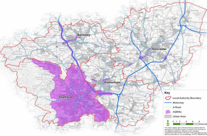
Our City Region faces significant air quality issues with 29 Air Quality Management
Areas (AQMAs) and high levels of carbon emissions around the centre of Sheffield
and along the motorways and A Roads. Poor air quality is linked to a variety of health
concerns ranging from short term illness to serious diseases and premature death. It
will also have an adverse impact on environment.
Across Sheffield there are 51 locations where the European Union’s annual average
limit value for NO2 (40 μg/m3) has been exceeded in one or more of the three year
period (2010-2012)25, and a 30% reduction in NO2 emissions would be needed in order
to comply with the limit value. Analysis indicates that road transport is the single most
significant contributor to Sheffield’s NO2 emissions at these locations.
To begin to address this issue SCR partners have been working together on a number
of initiatives that improve air quality and reduce emissions. This includes the ECO
Stars Fleet Recognition Scheme which is now the UK’s intervention of choice. From
its small beginnings in South Yorkshire ECO Stars is now been delivered across 27
authorities in the UK and 3 municipalities in Europe. It has a total a of 557 members
with over 75,000 assessed and awarded a star rating.
The scheme specifically targets commercial vehicles, actively engaging operators at
a local level with the specific aim of assisting and encouraging them to sustainable
operations. South Yorkshire has a total of 155 members with 12,200 vehicles assessed
and awarded a star rating.
SCR partners have also delivered a number of driver training initiatives, investment in
clean vehicles and the ground breaking Bus Partnerships in South Yorkshire that have
set progressive targets for vehicle investment. These interventions demonstrate our
collective commitment to improve the environment, but more work on this is needed
as Government’s National Air Quality Plan now requires change.
The Government’s National Air Quality Plan26 aims to improve air quality in those
cities and towns which make the greatest contribution to the NO2 problem and to do
so in the shortest time possible. The Government’s approach aims to combine targeted
intervention while creating economic opportunities and harnessing technological
innovation (e.g. ultra-low emission vehicles; investment in the road network and
public transport).
Sheffield has been identified as one of 29 cities that will have a duty to reduce NO2
below the statutory annual average mean of 40μg/m³. This is an important challenge
for Sheffield City Region and by meeting the requirements we will improve the health
of people who live and work in our towns and cities.
Figure 2.21 - Air Quality Management Areas (AQMAs) in South Yorkshire27
Low Emission Zone (LEZ) Feasibility Study Phase 2-Final Report (Sheffield City Council, 2013)
25
DEFRA (2017) UK plan for tackling roadside nitrogen dioxide concentrations (Defra, 2017)
26
Low Emission Bus Scheme Application (SYPTE)
27
29Sheffield City Region
50%
45%
40%
35%
Growth Rate of Diesel Cars
30%
25%
20%
15%
10%
5%
0%
2010 2011 2012 2013 2014 2015 2016
Year
SCR Growth Rate England Growth Rate
Figure 2.22 - Growth rate of diesel cars28
An emerging global transport trend is an increasing uptake of electric vehicles.
Advances in battery and other storage technologies, further reductions in costs
and improved efficiencies will mean that electrification is increasingly viable. Plans
to make electric vehicle charge points more widely available and convenient for
motorists were put forward by Government in October 2016 with all new diesel and
petrol cars banned by 2040.
In UK the number of newly registered ultra low emission vehicles rose by 250% in just
two years, and there has been a steady increase in plug-in vehicles in South Yorkshire
since 2012 (see Figure 2.23).
Sheffield City Region is well placed to develop hydrogen refuelling, with a hydrogen
refuelling station already in place at ITM Power in Rotherham, which sustainably
electrolyses hydrogen from water using wind power. The ability to build on this and
expand access to hydrogen as a fuel source is an important opportunity for SCR,
both in terms of the reducing emissions from road transport, but also in developing
our capability in the research and development of hydrogen refuelling technology –
equipping us with skills and technology we can export elsewhere.
Table VEH0105, Licensed vehicles by body type, diesel cars and vans, by upper and lower tier local authority, United Kingdom, annually (Department for Transport statistics, 2010 to 2016)
28
30Transport Strategy 2018 - 2040
1,600
Number of plug-in cars, vans and quadricycles
1,400
1,200
1,000
800
600
400
200
0
2011 2012 2013 2014 2015 2016
Year
Figure 2.23 - Number of plug-in cars, vans and quadricycles29 licensed in South Yorkshire30
In June 2017 there were 12,821 charging points in the UK31, increased from
approximately 1,500 in 2011. Figure 2.24 shows that only 2.9% of the UK charging
points are located in the Yorkshire & Humber region – the lowest of all UK regions.
With our City Region being characterised by a high reliance on private cars for
commuting, an increasing proportion of diesel vehicles (Figure 2.22), and the slow
adoption of electric charging points, this suggests a need for a technological step-
change and tough policy decisions for our City Region to address growing pressure on
deteriorating air quality.
Other
East of England
East Midlands
Yorkshire &
Humber
West Midlands
Wales
South West
South East
Scotland
Northern Ireland
North West
North East
London
Greater London
0% 2% 4% 6% 8% 10% 12% 14% 16%
Figure 2.24 - Profile of charging points across UK regions
Quadricycles are small electric cars of less than 400kg.
29
Table VEH0131, Plug-in cars, vans and quadricycles licensed at the end of quarter, UK, by local authority of registered keeper from 2011 (Department for Transport Statistics, 2016)
30
Charging point statistics (Zap Map, June 2017)
31
31Sheffield City Region
FREIGHT & DELIVERIES
The nature of freight and deliveries has evolved in recent years. Changes to the
logistics industry have resulted from customers’ demands for goods to be delivered
direct to them, in ever shorter timescales. Now, 40% of UK workers have personal
packages delivered to their workplace and 8% receive a package every single day.
This culture of online retail and door to door delivery puts significant pressure on road
space and local air quality through delivery vehicle emissions. In response to this,
some urban areas, such as Regents Street in London, are moving towards models
of freight consolidation and there is an existing consolidation centre at Meadowhall,
which serves the retail units within the shopping centre.
Consolidation centres can increase the efficiency of goods delivery, and help reduce
traffic and air pollution levels in city centres. For example, London’s Regent Street
consolidation centre allows retailers to consolidate deliveries from all suppliers in
one easily accessible location outside of the congestion charging zone. It has reduced
deliveries to participating retailers by 80% between 2009 and 201448. This type of
approach provides an opportunity to move congestion and large delivery vehicles out
of city centres, using smaller lower emission vehicles to do the last mile.
RESILIENCE
Resilience of the transport network to emerging shocks (both natural and man-
made) and chronic stresses is an important consideration for the balance of
investment. Resilience of a transport network is the ability to cope with and recover
from unexpected incident with the minimum disruption to all users Failure to plan
in resilience could cripple a system at any time and emerging threats are always
changing. As part of the design process for any scheme the potential to increase
the resilience of the network, particularly through proactive asset management and
maintenance, to the emerging shocks and chronic stresses need to be addressed.
Although the threat of climate change inclines towards a national / international scale
solution, our City Region is not immune to the potential consequences, such as extreme
weather conditions. Central estimates for climate change resulting from a medium
emission scenario forecasts an increase in the mean winter temperature of 2.2°C and an
increase in the mean summer temperature of 2.3°C32 by 2050 for the Yorkshire & Humber
region. It is also predicted that the mean winter precipitation will increase by 11% by 2050.
In 2007 major flooding on the River Don caused 2,300 properties to be flooded. Every
district within our City Region is at high risk of river flooding with many also at high
risk of surface water flooding in addition. The issue highlights the importance of
infrastructure resilience within our City Region. Action to combat this threat includes
investment in Sustainable Urban Drainage Systems (such as first phase of Grey to
Green at West Bar in Sheffield) and flood alleviation schemes in the River Don catchment
– with these being part funded by the SCR Infrastructure Fund (SCRIF) programme.
The efficient operation of buses and trams relies on a significant investment in
maintenance and minimisation of disruption. Across SCR, the coordination between
Local Highway Authorities, Public Transport Authorities and Public Transport Operators
remains of vital importance to deal with incidents and effectively communicate
disruptions to the travelling public. This includes bad weather such as flooding, ice
and snow, which without adequate planning can severely limit operation of public
transport networks. In some parts of our City Region, including Sheffield and the Peak
District, the hilly topography can exacerbate this challenge.
Network resilience limits our growth at present. In 2015 the DfT published the Trans-
Pennine Routes Feasibility Study, which identified that the existing trans-Pennine road
routes between our City Region and Manchester City Region experience a road closure
every 11 days on average, with two-thirds of these being longer than two hours.
77% of these closures are the result of either road traffic collisions or bad weather33.
This limited road connectivity restricts business interactions and opportunities for
increasing economic activity. This resilience issue is not reserved to roads, with
the TransPennine Rail route also experiencing higher levels of disruption and poor
alternatives make the journey unattractive. This is evidenced in the low commuting
rates between the two City Regions, as less than 1% of Sheffield’s residents commute
to Manchester despite this being a distance of less than 40 miles.
UK climate projections, medium emissions scenario (UKCP09 data licence)
32
Trans-Pennine Tunnel Study Stage 3 Report (DfT, February 2015)
33
32Transport Strategy 2018 - 2040
The issue is not only about TransPennine connections, with the electrification of
rail services elsewhere on the network expected to deliver reliability and resilience
benefits. Research undertaken for SCR highlights that electric units are generally
more reliable than diesels. The overall difference in reliability is influenced by the unit
selection. For example, the 140mph Javelin trains are affected by a ‘technical incident’
every 45,000 miles. This level of reliability offered by the Javelins is higher than the
current diesel Meridian fleet used on the Midland Mainline (39,500 miles per technical
incident, 12% lower), or the High Speed Trains (HST) (12,200 miles per technical
incident, 73% lower)34.
2.4 SOCIAL
2.4.1 SAFETY
The historical trend in casualty data for South Yorkshire shows a decrease in people
killed and seriously injured from collisions (Figure 2.25). Despite this general positive
pattern, the recent trend is levelling, and therefore safety still remains an underlying
and central consideration in transport.
In particular, the national trend in people killed and seriously injured from collisions
shows that although car casualties have decreased, cycle casualties have increased.
As many of our wider objectives (such as reducing congestion, improving air quality
and tackling obesity) point towards increasing active mode share as a solution, the
safety of cyclists and pedestrians must be of upmost importance.
When designing interventions to tackle safety issues and promote safer travel the
approach needs to reflect the needs of different groups. The need to focus on groups
most at risk is important in deciding where to intervene. High risk groups, for example
children and young drivers, will remain a priority group for investment. Alongside
this focus on high risk groups, changes to National Policy, for example penalties for
the use of mobile phones while driving, will require action at a local level to inform all
drivers of the risks and penalties.
1,750 100,000
KSI All
KSI - GB
90,000
1,500
80,000
70,000
1,250
60,000
KSI GB - Total
KSI SY - Total
Seat Belts
1,000 50,000
Bus De-regulation 40,000
750
30,000
Rear Seatbelts
20,000
500
10,000
Mobile phone use in car becomes an offence
250 0
9 980 1981 1982 1983 1984 1985 1986 1987 1988 1989 1990 1991 1992 1993 1994 1995 1996 1997 1998 1999 2000 2001 2002 2003 2004 2005 2006 2007 2008 2009 2010 2011 2012 2013 2014 2015
197 1
KSI All 1,482 1,446 1,447 1,493 1,326 1,234 1,098 1,108 935 1,004 1,025 1,002 909 845 696 715 746 742 731 725 733 686 715 740 748 705 658 626 639 585 530 435 471 479 481 469 401
KSI - GB 86,896 84,859 84,105 85,682 76,068 78,658 76,145 74,142 69,418 68,543 68,531 65,658 56,186 53,485 48,834 50,190 49,154 48,097 46,583 44,255 42,545 41,564 40,560 39,407 37,215 34,351 32,155 31,845 30,720 28,572 26,912 24,510 25,023 24,793 23,370 24,582 23,869
Number of people killed and seriously injured in South Yorkshire and GB over the same time period as a comparison
Figure 2.25 - Number of people killed and seriously injured35
Midland Main Line Electrification: Reinforcing the Case for Investment (Aecom/SCR, 2015)
34
Making South Yorkshire Roads Safer: A Safer Roads Partnership Strategy 2017-2026 (South Yorkshire Local Transport Partnership, 2017)
35
33Sheffield City Region
2.4.2 SOCIAL INCLUSION
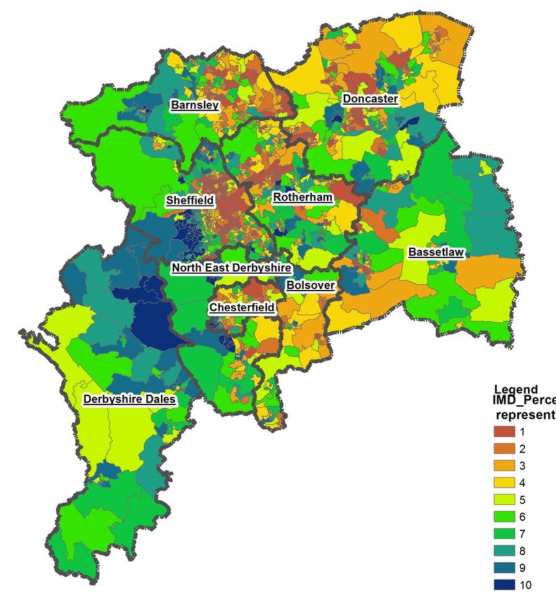
Our City Region ranks as the 7th most deprived LEP area in England. Figure 2.26
shows that there are widespread areas within our City Region that are within the
most deprived in the country, and in some locations (e.g. Rotherham) deprivation has
increased between 2007 and 2015.
IMD Percentile
(where 1 represents 10%)
1
2
3
4
5
6
7
8
9
10
Figure 2.25 - Deprivation across SCR36
The latest census data (2011) identified that 29.5% of households in South Yorkshire do
not have access to a car. It is essential that key services and employment opportunities
remain accessible to all, including the most deprived areas of our City Region. This can
be achieved through provision of effective public transport and encouraging adoption
of active modes of travel. However, inclusive economic growth is being hindered by
reductions in the extent and level of service provided by the bus network, suspensions
to Supertram services, and rising cost of travel (single and return tickets) by public
transport, as shown in Figure 2.27.
In many cases the areas with greatest reliance on public transport (i.e. those without
access to a car) are the most deprived areas across SCR. Recent research by the Centre
for Regional Economic and Social Research (CRESR)37 indicates that the barriers
to travelling require targeted interventions that help people overcome financial,
informational, perceptual and emotional barriers to making trips to hitherto unfamiliar
destinations, or to overcome stigmatised perceptions of their home area. The report
suggests that such interventions also need to be of sufficient scale and duration to have
a significant effect.
English Indices of Deprivation (Department of Communities and Local Government, 2015)
36
Addressing transport barriers to work in low income neighbourhoods (CRESR, 2017)
37
34Transport Strategy 2018 - 2040
The stretch to household budgets is also a significant barrier to travelling. The CRESR
report38 highlights the most recent ONS figures for household expenditure where
transport accounts for 14% of an average household budget. Excluding mortgage
and rental payments, this is now the most significant household cost. For lower
income households the report goes on to highlight that the ability to afford transport
is challenged by essential needs including heating and food, with low income
households having significantly lower expenditure on transport than higher income
households.
The impact on accessibility to opportunities for deprived communities could be in part
explained by the growing gap between the slow growth in wage levels compared to
rises in public transport fares. In recent years the cost of travelling by public transport
fare has increased above inflation as have other living costs, whereas wage growth
has stagnated.
The patterns and timing of work are also creating a challenge for people who are
reliant on public transport to enter employment. The current provision of public
transport does not support a 24/7 economy - whilst shift patterns continue throughout
the day and night, the public transport network does not provide services 24 hours
a day, although where possible SYPTE and operators will timetable buses to
accommodate shift patterns at employment sites. This can hinder the ability for people
to enter the labour market. Public transport in its current form may not be the solution
to this challenge as the density and timing of journeys cannot always be supported
commercially or through subsidy. A more flexible solution may be required.
£2.40
Average Fare across South Yorkshire
£2.20
£2.00
£1.80
£1.60
£1.40
£1.20
£1.00
2007 2008 2009 2010 2011 2012 2013
Year
Bus Rail Tram
Figure 2.27 - Change in average passenger transport fare in South Yorkshire39 (These figures are based on single or return journey fares and better value
tickets are available for frequent travellers).
Ibid
38
Trends in average passenger transport fare (SYPTE, 2007 to 2013)
39
35You can also read


