Parking Controls Review - Cremorne Enterprise Precinct G28313R-01C Prepared for Yarra City Council
←
→
Page content transcription
If your browser does not render page correctly, please read the page content below
Parking Controls Review
Cremorne Enterprise Precinct

Prepared for
Yarra City Council

July 2020

G28313R-01C

Level 28, 459 Collins St   T: 03 9822 2888             Traffix Group Pty Ltd
Melbourne Victoria 3000    admin@traffixgroup.com.au   ABN: 32 100 481 570     traffixgroup.com.au
Parking Controls Review                                                               Cremorne Enterprise Precinct

Document Control
Our Reference: G28313R-01C

        Issue No.                        Type                           Date                     Prepared By                   Approved By

              A                          Draft                     30/06/2020                      L. Furness                    C. Dunstan

              B                    Revised Draft                   20/07/2020                      L. Furness                    C. Dunstan

              C                          Final                     21/07/2020                      L. Furness                    C. Dunstan

COPYRIGHT: The ideas and material contained in this document are the property of Traffix Group (Traffix Group Pty Ltd – ABN 32 100 481 570). Use
or copying of this document in whole or in part without the written permission of Traffix Group constitutes an infringement of copyright.

LIMITATION: This report has been prepared on behalf of and for the exclusive use of Traffix Group’s client and is subject to and issued
in connection with the provisions of the agreement between Traffix Group and its client. Traffix Group accepts no liability or responsibility
whatsoever for or in respect of any use of or reliance upon this report by any third party.

                                                                                      G28313R-01C                                               2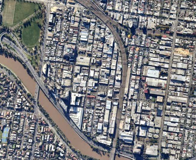
Parking Controls Review                                Cremorne Enterprise Precinct

Executive Summary
The purpose of this project is to introduce new car parking provisions in the Yarra Planning
Scheme, that responds to local parking issues within the Cremorne Enterprise Precinct. The
objectives of the project are to:
•   Outline local parking issues, in the context of Cremorne as an enterprise precinct, to
    determine how the current provisions are applied and how the decision making process
    operates.
•   To identify the average variation to the standard requirements in Clause 52.06 as
    approved by Council and/ or the Victorian Civil and Administrative Tribunal (VCAT) in land
    zoned Commercial 2 (C2Z) and Comprehensive Development (CDZ).
•   To provide the strategic justification and rationale to reduce the provision of off-street car
    parking to promote more sustainable modes of transport and maximise floor areas for
    employment generating uses, rather that car parking.
•   To establish clear, logical, and relevant car parking objectives for Cremorne’s commercial
    areas to guide the exercise of discretion.
•   To justify any variations in parking rates, including maximum rates, proposed via new car
    parking provisions.
This report provides a review of the existing parking needs and issues within Cremorne and a
recommendation for new parking controls for the Cremorne Enterprise Precinct in the form of
a Parking Overlay. The Overlay is to be applied to the Commercial 2 Zone and the
Comprehensive Development Zone (Schedule 2 and 3) is designed to support the continued
growth of Cremorne as a key area for employment within Yarra and inner Melbourne. The
preparation of this report has had regard to both PPN57: The Parking Overlay and PPN22:
Using the Car Parking Provisions.
The need for a review of the parking controls is borne out of a number of factors including:
•   That Cremorne is undergoing a rapid rate of development, land use change and
    intensification.
•   Cremorne is attracting a significant number of trips from outside the Precinct.
•   Cremorne has a constrained road network that experiences high levels of traffic
    congestion.
•   Tensions between businesses, residents and visitors to the area.
This report builds on a foundation of a number of strategic and transport planning studies
which have been produced by Yarra City Council, DELWP and others in recent years regarding
planning in Cremorne. These studies emphasis the unique advantages of Cremorne, in
particular its ability to attract and provide employment in the emerging knowledge economy,
its inner-city location and unique urban environment and its connection to transport.
Cremorne has a number of unique transport challenges and opportunities, namely:
•   The road network within Cremorne is constrained in a number of ways:

                                                       G28313R-01C                            3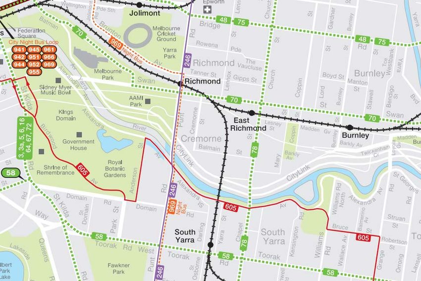
Parking Controls Review                                Cremorne Enterprise Precinct

    –   Cremorne’s connections to the arterial road network are limited in all directions,
        particularly to the north, west and south.
    –   The arterial road network and its connections to Cremorne are congested during the
        commuter peak hours and there are very limited options to increase the traffic
        capacity of the arterial road network or its connections into Cremorne.
    –   The rail lines through Cremorne form barriers to movement of all transport modes with
        only a limited number of crossing points.
    –   It is served by a dense network of narrow roads. Many of these roads operate in a
        one-way direction. A significant number of the roads are akin to laneways with narrow
        cross sections and have limited traffic carrying capacity.
•   Cremorne is highly accessible by public transport. This includes ‘local’ tram and bus
    services and city-wide services via the metropolitan rail network.
•   There is high quality bicycle infrastructure in the area around Cremorne, however the
    connections to this infrastructure are not at the same high level.
•   Cremorne is highly walkable from a geographic standpoint. However, the quality of the
    pedestrian infrastructure within the local road network is generally poor, with key issues
    being narrow footpaths/verges, variable surface quality, infrastructure obstructing
    footpaths and generally poor pedestrian amenity.
•   On-street parking is highly controlled, with limited options for long-term (staff) parking
    using public parking resources. Demand for car parking within Cremorne is generally very
    high during business hours and lower during the evening and on weekends.
Given the above constraints, the future of transport into Cremorne is via sustainable transport
modes – walking, cycling and public transport. While there are issues with the walking and
cycling environment within Cremorne itself, its location and access to public transport modes
means that Cremorne already has the key attributes required to support sustainable transport
choices. The congestion and traffic capacity constraints should be seen as a benefit in
encouraging sustainable transport modes.
In the context of the above, the Parking Overlay recommended by this report is primarily
designed to reduce the parking requirements of employment generating developments. This
will assist the development of Cremorne by:
•   Encouraging sustainable transport modes.
•   Reducing the traffic impacts of new office/commercial developments.
The following requirements are recommended for the Parking Overlay:
•   The Office car parking rate is set at a maximum parking rate of 1.0 car spaces per 100m2
    Net Floor Area (NFA).
•   The Retail car parking rate is set at a maximum parking rate of 1.0 car spaces per 100m2
    Leasable Floor Area (LFA).
All other uses are to remain at the current minimum requirements of Column B of Clause
52.06-5.
The provision of maximum parking rates is specifically designed to:

                                                       G28313R-01C                           4
Parking Controls Review                               Cremorne Enterprise Precinct

•   Support sustainable transport outcomes.
•   Reduce future demand for private transport and consequential traffic congestion impacts.
•   Remove planning barriers to the provision of low car parking.
•   Provide a means to control the over-supply of car parking.
•   Provide certainty to stakeholders, decision makers and the community with regards to car
    parking outcomes.
•   Discourage costly (and which may also become redundant in future) car parking solutions.
‘Office’ is a particular use that is an important target for mode shift due to its impact on the
road network and is a key land use for the Commercial 2 Zone within Cremorne. Office
parking is a key generator of traffic during the road network peak hours and this peak demand
occurs at the peak availability of public transport services (i.e. services are at their most
frequent). Importantly, office car parking generates 2 to 3 times more traffic on a per car
space basis during peak hours than a residential car space.
Retail is generally a secondary land use to office within Cremorne. The retail rate is designed
to recognise that the same issues with staff parking for office uses also applies to retail uses.
It also recognises that in many cases the retail component of a development in Cremorne is
small and provides local service and amenities to local workers and residents of the area, who
do not require car parking to access the use.
The Parking Overlay is also accompanied by a set of additional decision guidelines, required
for when applications seek to exceed the maximum rates imposed. Developments seeking to
exceed the maximum requirements should still encourage sustainable transport patterns and
not negatively impact the local transport network.

                                                      G28313R-01C                            5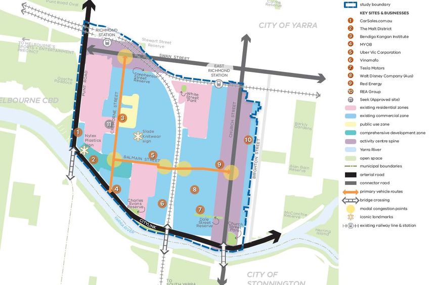
Parking Controls Review                                                                Cremorne Enterprise Precinct

Table of Contents
1.       Introduction............................................................................................................................ 9

2.       Methodology .......................................................................................................................... 9
2.1.     Reference documents ....................................................................................................................... 9

3.       Proposal and Background..................................................................................................... 11
3.1.     The Cremorne Enterprise Precinct .................................................................................................. 12
3.2.     Future Demand for Office Space ..................................................................................................... 14
3.3.     Work Underway ................................................................................................................................ 15
3.3.1.   Cremorne Issues and Opportunities Paper .................................................................................... 15
3.3.2.   Cremorne Issues and Opportunities Paper – Stage 1 Community Engagement ......................... 16
3.3.3.   Cremorne Streets and Movement Strategy (Draft)........................................................................ 16

4.       Policy Context ...................................................................................................................... 17
4.1.     Plan Melbourne 2017-2050 ............................................................................................................. 17
4.2.     Local Planning Policies and Strategy .............................................................................................. 19
4.3.     Planning Practice Notes .................................................................................................................. 20

5.       Existing Conditions............................................................................................................... 22
5.1.     Study Area........................................................................................................................................ 22
5.2.     Regional Context ............................................................................................................................. 23
5.3.     Local Context ................................................................................................................................... 24
5.4.     Review of Transport Network .......................................................................................................... 25
5.4.1.   Road Network .................................................................................................................................. 25
5.4.2.   Capacity Limitations ....................................................................................................................... 29
5.5.     Sustainable Transport ..................................................................................................................... 30
5.5.1.   Public Transport .............................................................................................................................. 30
5.5.2.   Cycling Network .............................................................................................................................. 34
5.5.3.   Pedestrian Network ........................................................................................................................ 36
5.5.4.   Car Share Vehicles .......................................................................................................................... 38
5.6.     Review of Existing Travel Patterns .................................................................................................. 38
5.6.1.   Consultation .................................................................................................................................... 39
5.7.     Car Parking Conditions .................................................................................................................... 40
5.7.1.   Off-Street Parking............................................................................................................................ 46
5.8.     Summary of Existing Conditions ..................................................................................................... 48
5.9.     Cremorne Streets and Movement Strategy (Draft) – Consultation Report..................................... 49
5.10.    Recent Land Development within Cremorne ................................................................................... 49

6.       The Parking Overlay ............................................................................................................. 52
6.1.     Definition of Objectives ................................................................................................................... 53

                                                                                       G28313R-01C                                                     6
Parking Controls Review                                                                 Cremorne Enterprise Precinct

6.2.     Parking Overlay Rates...................................................................................................................... 54
6.2.1.   Existing Situation ............................................................................................................................ 54
6.2.2.   Proposed Parking Overlay Rates .................................................................................................... 55
6.2.3.   Review of Adopting Maximum Rates ............................................................................................. 56
6.3.     Review of the Proposed Office Rate................................................................................................ 58
6.4.     Review of Proposed Retail Rate ...................................................................................................... 61
6.5.     Basis for the Reduced Car Parking Rates ....................................................................................... 61
6.5.1.   Reduction in Traffic Impacts of New Development....................................................................... 61
6.5.2.   The availability of convenient and efficient public transport in this area ..................................... 63
6.5.3.   Walking ............................................................................................................................................ 63
6.5.4.   Cycling ............................................................................................................................................. 64
6.5.5.   The lack of Impact on Public Parking ............................................................................................ 64
6.5.6.   Proximity to Services ...................................................................................................................... 65
6.6.     Parking Overlay Car Parking Rates Summary ................................................................................. 65
6.7.     Parking Overlay Decision Guidelines ............................................................................................... 65

7.       Conclusions ......................................................................................................................... 68

List of Figures
Figure 1: Cremorne Enterprise Precinct (Source: Yarra City Council)                     11
Figure 2: Ingredients of a Successful Enterprise Precinct (DWELP, 2018)                 13
Figure 3: The 20-minute neighbourhood (Source: Plan Melbourne)                          18
Figure 4: Cremorne Zoning Map                                                           22
Figure 5: Cremorne's location relative to the central city (Source: Plan Melbourne)     23
Figure 6: Key Attributes Map of Cremorne (Source: Cremorne Issues and Opportunities Paper,
2019)                                                                                   25
Figure 7: Existing Access Constraints (Source: Cremorne Traffic Assessment, DoT/MRPV) 27
Figure 8: Existing Daily Traffic Volumes (Source: Cremorne Traffic Study 2019, DoT/MRPV)
                                                                                        28
Figure 9: Public Transport Map of Cremorne and surrounds (Source: www.ptv.com.au)       31
Figure 10: Principal Public Transport Network Map (Source: Planning Schemes Online)     33
Figure 11: Travelsmart Map (Source: City of Yarra website)                              34
Figure 12: Existing and Proposed Strategic Cycling Corridors (Source: Department of
Transport Open data)                                                                    35
Figure 13: Walkscore Map (Source: https://www.walkscore.com/AU-
VIC/Melbourne/Cremorne)                                                                 37
Figure 14: Parking restrictions (business hours)                                        42
Figure 15: Current extent of car parking sensors in Cremorne and area of analysis       43
Figure 16: August car parking occupancy (17 -23 August, 2019)
                                               th  rd
                                                                                        45
Figure 17: February car parking occupancy (15th-16th & 24th-28th February, 2020)        45
Figure 18: Off-street carparks                                                          47

                                                                                        G28313R-01C                                                       7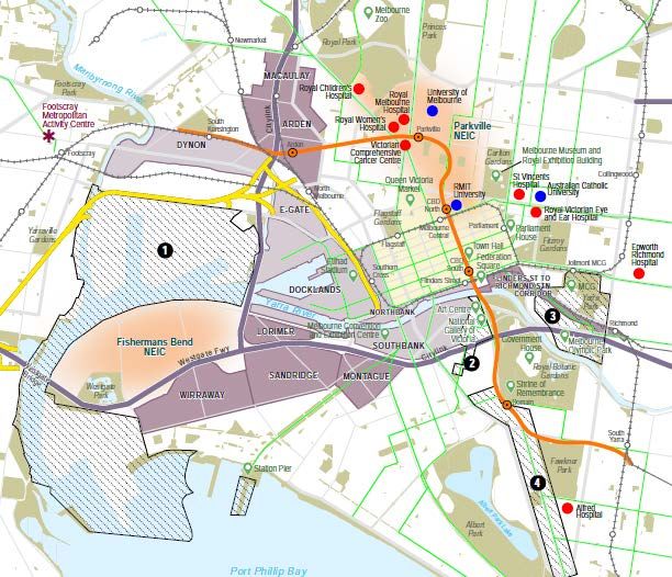
Parking Controls Review                                Cremorne Enterprise Precinct

List of Tables
Table 1:   Arterial Road Traffic Volumes (Source: Department of Transport Open data, 2020)   26
Table 2:   Summary of Public Transport Services                                              32
Table 3:   Journey to Work Data: 2016 Census, ABS                                            39
Table 4:   Off-street Public car parking summary                                             47
Table 5:   Summary of Office Development Approvals                                           50
Table 6:   Reduced Office Car Parking Rates                                                  59
Table 7:   Review of Decision Guidelines                                                     66

List of Appendices
Appendix A     Parking Restriction Map

Appendix B     Recommended Parking Overlay

Appendix C     Clause 52.06 of the Yarra Planning Scheme

                                                       G28313R-01C                       8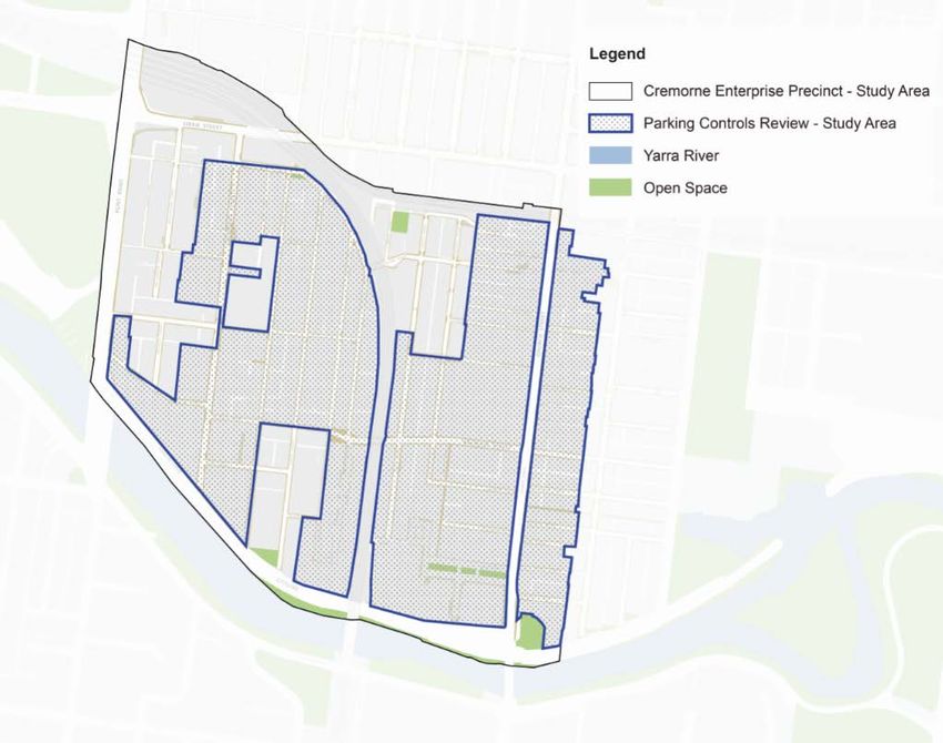
Parking Controls Review                              Cremorne Enterprise Precinct

1. Introduction
The State Government is currently promoting ‘Enterprise Precincts’ as hubs for the emerging
knowledge economy. These precincts are designed to create new jobs and better respond to
changes in the economy and evolving ways of working. Enterprise precincts are typically
dense, accessible, and amenity-rich urban areas that provide fertile ground for business
formation and idea development and innovation. Cremorne has been identified as a Pilot
Enterprise Precinct.
Traffix Group has been engaged by Yarra City Council to undertake a review of the parking
controls that should apply within the Commercial 2 Zoned land in and the Comprehensive
Development Zone (Schedule 2 and 3) Cremorne in the context of its status as an Enterprise
Precinct and key employment generator.
Cremorne is a unique area within inner Melbourne that faces particular transport challenges
and opportunities. The implementation of a Parking Overlay is designed to support the
growth of the precinct and the desired transport outcomes within Cremorne.

2. Methodology
This report reviews the transport engineering challenges and opportunities facing Cremorne
and provides recommendations in regard to new parking controls that will assist in
implementing Council’s vision for the Cremorne Enterprise Precinct.
In formulating the recommendations of this report, the study included the following
methodology:
•   A review of background documents, planning and transport studies prepared by Council
    and others in relation to Cremorne.
•   A review of Cremorne’s planning policy context, state and local planning policies and
    PPN57: The Parking Overlay and PPN22: Using the Car Parking Provisions.
•   Review of recent planning permit applications and approvals within Cremorne over the last
    5 years.
•   Analysis of car parking resources, management and demand within Cremorne.
•   Results of surveys of employers and employees within Cremorne.
•   A collaborative approach has been undertaken with Council Officers, including a number
    of workshops and team meetings.

2.1.   Reference documents
This report relies on the following key background documents prepared by Yarra City Council
and others:
•   Cremorne Traffic Assessment (2019)
•   Cremorne Streets and Movement Strategy (Draft) – Consultation Document (2019)
•   DELWP – Unlocking Enterprise in a Changing Economy

                                                     G28313R-01C                            9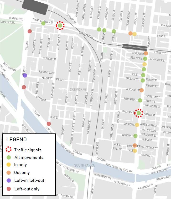
Parking Controls Review                            Cremorne Enterprise Precinct

•   Yarra Office Demand Study (2018)
•   Cremorne Issues and Opportunity Paper (2019)
•   Adopted Yarra Housing Strategy (2018)
•   Adopted Yarra Spatial Economic and Employment Strategy (2018)

                                                   G28313R-01C                    10
Parking Controls Review Cremorne Enterprise Precinct
3. Proposal and Background
The study area is the Cremorne Enterprise Precinct, as defined in the following figure.
The blue outline defines the study area of the Cremorne Place Implementation Plan (i.e. the
Enterprise Precinct). The blue line defines the Parking Overlay study area which includes land
zoned:
• Commercial 2
• Comprehensive Development Zone (Schedule 2 and 3)
The Overlay would not apply to Public Use Zones (PUZ) or Public Park and Recreation Zones
(PPRZ). It would also not apply to the Swan Street Activity Centre.
Figure 1: Cremorne Enterprise Precinct (Source: Yarra City Council)
This review of parking controls in the area is the result of a number of issues which have
developed in recent years within the Cremorne area, specifically:
• That Cremorne is undergoing a rapid rate of development, land use change and
intensification.
• Cremorne is attracting a significant number of trips from outside the Precinct.
G28313R-01C 11Parking Controls Review Cremorne Enterprise Precinct
• Cremorne has a constrained road network that experiences high levels of traffic
congestion.
• Has an established parking provision deficit.
• Experiences physical constraints and market conditions that affect the future provision of
car parking.
• Tensions between businesses, residents and visitors to the area, including as a result of
new development.
3.1. The Cremorne Enterprise Precinct
Cremorne has emerged as an ‘Enterprise Precinct’ of State significance suitable for the
growing knowledge and services-based economy with an output of $2.7 billion and over
10,000 workers at present. Cremorne has become a key destination for local and global high
technology companies and demand for employment within the suburb continues to grow.
Enterprise precincts are defined as typically dense, accessible, and amenity-rich urban areas
that provide fertile ground for business formation and idea development and innovation.
The policy document, Unlocking Enterprise in a Changing Economy (Victoria. Department of
Environment, Land, Water and Planning, 2018), provides a framework to identify and support
Enterprise Precincts. Cremorne had been identified as a Pilot Enterprise Precinct. Designated
Pilot Enterprise Precincts are intended to provide guidance to other local government, industry
and communities on how new partnerships can be formed to further Enterprise Precincts in
Victoria. The Unlocking Enterprise in a Changing Economy policy includes the following
description of Cremorne:
Cremorne has emerged as Australia’s premier destination for creative design, particularly in
the tech and digital space. Its reach is now global, with several billion dollar tech firms
mixing healthily with small-to-medium sized entities, start-ups and co-working spaces.
Enabled by the City of Yarra’s foresight and steadfastness to retain its employment focus,
and spurred by some committed and engaged local landowners and businesses, Cremorne
is going through a profound period of growth, reinforcing its industry specialisation and
strategic potential, and furthering Melbourne’s economic ecosystem.
Drawing from its industrial heritage and building stock, proximity to central Melbourne,
diversity of small and large land parcels, pokey laneways complementing good public
transport access, and the amenities provided on Swan and Church Streets, Cremorne has
all the characteristics of an enterprise precinct tailored to the needs of the emerging
economy.
Reflecting these characteristics, development activity is running hot in Cremorne. During
this period of rapid change, the challenge will be in ensuring development adds to the
precinct’s economic functioning and ‘buzz’, maintaining it as a creative place to work for
years to come.
- Unlocking Enterprise in a Changing Economy (DELWP, 2018)
The Unlocking Enterprise in a Changing Economy policy document identifies 9 key ingredients
for a successful Enterprise Precinct. These are identified below.
G28313R-01C 12Parking Controls Review Cremorne Enterprise Precinct
Figure 2: Ingredients of a Successful Enterprise Precinct (DWELP, 2018)
Two of these ingredients are closely linked to transport, Accessibility and by extension, Quality
of Place.
While Access and Infrastructure most clearly have transport implications, Quality of Place is
also an important consideration. The street network of a precinct has a strong role to play in
providing a quality urban environment and as this report shows, while Cremorne has potential
in this area, it also suffers from a variety of transport and urban environment issues at the
local level.
G28313R-01C 13Parking Controls Review Cremorne Enterprise Precinct
3.2. Future Demand for Office Space
Cremorne has become a key destination for local and global high technology companies.
Yarra City Council has provided information to Traffix Group of issued and current planning
applications indicating that Council has approved (some currently under construction or
recently completed) or is currently considering over 150,000m2 of additional office floor space
within Cremorne. This is discussed in more detail at Section 5.10.
The ‘Yarra Office Demand Study’ 1 (Urban Enterprise, March, 2018) identified that Cremorne
and the City of Yarra has a number of competitive advantages which uniquely position the
municipality to cater to the needs of contemporary businesses and workers. This include:
• A favourable zoning and development profile (particularly the availability of C2Z land);
• Industrial heritage and opportunities for re-use and adaptation of heritage buildings;
• Strategic location – proximity to CBD and eastern suburbs;
• Transport connectivity;
• Public transport and cycling infrastructure;
• Strong lifestyle attributes and vibrant precincts; and
• Recognition and brand equity for creative and tech-based enterprise.
The ‘Yarra Office Demand Study’ also identified a number of trends within the City of Yarra
and Cremorne:
• Between 2011 and 2016, the number of jobs in Cremorne increased by 4,000, a percentage
increase of 61%.
• Cremorne has emerged as major tech precinct of national significance, accommodating a
number of the major companies in Australia (MYOB, Tesla, REA, Carsales, Uber, Seek
future).
• Demand for office floor space is expected to be strong in the short to medium term (up to
10 years).
These strengths have supported a growing business base, particularly small and medium
enterprise. However, in recent years there has been increasing interest from larger businesses
and regional headquarters.
A key driver of increased demand in Yarra has been the increased competition between
companies to attract and retain talented workers (particularly in the creative and technology
sectors). For younger workers in these industries, Yarra’s office precincts provide lifestyle
benefits which appeal to these workers more than areas perceived as being ‘sterile’ or ‘bland’
environments of traditional office precincts in the CBD and Docklands.
These factors combine to underpin strong demand for office space in Yarra at present and
indicate a competitive advantage in relation to attracting businesses seeking a young, creative,
and skilled workforce.
1
Prepared for the City of Yarra by Urban Enterprise, dated March 2018
G28313R-01C 14Parking Controls Review Cremorne Enterprise Precinct
3.3. Work Underway
A key Pilot Enterprise Precinct initiative is the development of the Cremorne Place
Implementation Plan (CPIP), which will provide a high-level vision for the future of Cremorne
and a prioritised set of projects that will progress delivery of that vision.
Concurrent with preparation of the CPIP, the City of Yarra is completing/has completed a
number of projects as part of the broader CPIP.
a) Cremorne Issues and Opportunities Paper (Nov, 2019). This work aimed to identify issues
and opportunities in Cremorne to be reviewed as part of this project. This was completed
in November, 2019.
b) Cremorne Issues and Opportunities Paper – Stage 1 Engagement Outcomes Summary
Report (Feb, 2020).
c) Cremorne Streets and Movement Strategy (Draft) – Consultation Document (Oct, 2019).
This strategy aims to identify key transport and movement issues and opportunities and
put forward a vision for streets and people movement, including some high-level concepts
of how this could be achieved. The purpose of the Strategy is to set out a vision,
opportunities and urban design response.
3.3.1. Cremorne Issues and Opportunities Paper
This paper identifies issues and opportunities in Cremorne. In regard to transport and
movement, the paper identifies the following key considerations:
• Cremorne is a relatively small area built around tight streets and there is competition
between different road users. The two primary gateways to the precinct, Cremorne and
Balmain streets, are becoming increasingly congested as more people live, work or visit the
precinct.
• There is a need to address movement challenges, including the appropriate provision of
carparking, safety of pedestrians and cyclists, traffic circulation and traffic calming
throughout the precinct.
• The barriers to movement and constrained street network make orientation and navigating
through the precinct difficult for all transport users and visitors to the area.
• Due to forecast growth in trip demand and minimal capacity for the network to
accommodate more car movements, there is a need to improve and promote sustainable
transport modes, focussing on pedestrian safety and level of service on the transport
network.
• Provision also needs to be made to retain vehicle access throughout the precinct to support
the needs and requirements of existing residents and businesses operating in the precinct.
• There is an opportunity to consider trialling different approaches to off-street parking
provision and management and on street use of space.
The report identifies the following key opportunities within Cremorne:
• Increasing use of public transport through better access and infrastructure investment
G28313R-01C 15Parking Controls Review Cremorne Enterprise Precinct
• Balance the demands of different road users to provide a safer and more efficient road
network.
• Develop infrastructure to support increased active transport
• Promote the most efficient management and use of car parking supply
3.3.2. Cremorne Issues and Opportunities Paper – Stage 1 Community Engagement
The purpose of this phase of engagement was to gather community and stakeholder views on
the Cremorne Issues and Opportunities Paper. Stage One community engagement was
undertaken in November-December 2019 to inform the preparation of the Plan.
The key findings of the consultation in relation to transport issues were:
• The strongest overall support was for walking as a priority mode of transport and
improvements to public transport.
• Participants also strongly supported reviewing car parking provisions, improving the cycling
and pedestrian networks, installing protected bike lanes, and piloting other safety measures
such as reduced speed limits to protect cyclists and pedestrians.
• Car sharing and bike sharing were least supported. This may be due to a perceived
importance of addressing transport congestion in Cremorne.
3.3.3. Cremorne Streets and Movement Strategy (Draft)
The purpose of the draft Cremorne Streets and Movement Strategy is to assist Council in the
effective planning for a major increase in trip demand associated the increased development
within Cremorne. This additional development results in increased movement on a local road
network which is already operating at, or near, peak vehicle capacity.
This is summarised in the strategy as follows:
The increasing demands on street space driven by land use intensity within Cremorne
requires greater priority to be allocated to more space-efficient travel modes (walking,
cycling, train, tram, bus) whilst still recognising the importance of providing space for
essential services, deliveries, residents and those with special needs. Private vehicle travel
is not considered a priority or mass transit mode in this area, and future planning must
recognise the limitations of car access into and through Cremorne, while protecting the
ability of the network to support existing and future economic activity.
Another key component of the strategy is the treatment of streets as places, not just being
required for the purposes of movement. The Strategy is implementing a key policy directive
of Plan Melbourne:
Policy 4.1.2 - Integrate place-making practices into road-space management
Streets are both places to pass through and destinations. There is a need to balance the
competing demands of movement and place in defining the priority functions of streets.
This will help create a sense of place and structure across the city.
It is also recognising that access and quality of place are key ingredients for an Enterprise
Precinct.
G28313R-01C 16Parking Controls Review Cremorne Enterprise Precinct
This draft strategy highlights that the streets within Cremorne are currently weighted in favour
of movement (including providing on-street car parking) and generally have very limited sense
of place.
To achieve both of these objectives requires a reallocation of road space within Cremorne to
prioritise access and safety for pedestrians, cyclists and public transport users. A significant
amount of the reallocated road space will ultimately come from existing on-street car parking
and in some cases, traffic space.
4. Policy Context
4.1. Plan Melbourne 2017-2050
Plan Melbourne is a long‐term vision to ensure that Melbourne grows more sustainable,
productive and liveable as its population approaches 8 million. It is a long‐term plan designed
to respond to the state-wide, regional and local challenges and opportunities Victoria faces
between now and 2050.
The objectives of Plan Melbourne are supported by a series of directions, initiatives and
actions. The development of Cremorne relates to a range of initiatives outlined in Plan
Melbourne including:
1. Melbourne is a productive city that attracts investment, supports innovation and creates
jobs
• Direction 1.1: Create a city structure that strengthens Melbourne’s competitiveness for
jobs and investment
• Direction 1.2: Improve access to jobs across Melbourne and closer to where people live
• Direction 1.3: Create development opportunities at urban renewal precincts across
Melbourne
Apart from these initiatives, increasing development in Cremorne will also assist with
delivering on key directions including:
• Direction 2.2: reduce the cost of living by increasing housing supply near services and public
transport (in this case, by bring employment new housing and public transport services)
• Direction 4.1: create a city of 20-minute neighbourhoods
• Direction 4.3: create neighbourhoods that support safe communities and healthy lifestyles.
Plan Melbourne 2017‐2050 (Direction 5.1) states that a 20‐minute neighbourhood must:
• be safe, accessible and well connected for pedestrians and cyclists to optimise active
transport.
• offer high‐quality public realm and open space.
• provide services and destinations that support local living.
• facilitate access to quality public transport that connects people to jobs and higher‐order
services.
G28313R-01C 17Parking Controls Review Cremorne Enterprise Precinct
• deliver housing/population at densities that make local services and transport viable.
• facilitate thriving local economies.
Plan Melbourne goes on to state that:
The 20-minute neighbourhood is all about ‘living locally’— giving people the ability to meet
most of their everyday needs within a 20-minute walk, cycle or local public transport trip of
their home.
Figure 3 is an extract from Plan Melbourne which encapsulates what a 20-minute
neighbourhood means.
The creation of new employment opportunities within Cremorne, which is highly walkable, well
connected via quality public transport and bicycle facilities, accords with the vision of Plan
Melbourne 2017‐2050 in terms of creating a ’20‐minute neighbourhood’. A 20-minute
neighbourhood also means that local employment opportunities are available which are well
connected to public transport services.
Figure 3: The 20-minute neighbourhood (Source: Plan Melbourne)
G28313R-01C 18Parking Controls Review Cremorne Enterprise Precinct
4.2. Local Planning Policies and Strategy
Yarra City Council supports sustainable transport and design in new and existing
developments through a number of policies and initiatives. These are summarised as
follows.
Municipal Strategic Statement – Clause 21.06 Transport
Clause 21.06 of the Yarra Planning Scheme identifies the following objectives and associated
strategies in relation to transport:
21.06-1 Walking and cycling
Objective 30 To provide safe and convenient pedestrian and bicycle environments.
Strategy 30.1 Improve pedestrian and cycling links in association with new development
where possible.
Strategy 30.2 Minimise vehicle crossovers on street frontages.
Strategy 30.3 Use rear laneway access to reduce vehicle crossovers.
21.06-2 Public transport
Objective 31 To facilitate public transport usage.
Strategy 31.1 Require new development that generates high numbers of trips to be easily
accessible by public transport.
21.06-3 The road system and parking
Objective 32 To reduce the reliance on the private motor car.
Strategy 32.1 Provide efficient shared parking facilities in activity centres.
Strategy 32.2 Require all new large developments to prepare and implement integrated
transport plans to reduce the use of private cars and to encourage walking, cycling and
public transport.
Objective 33 To reduce the impact of traffic.
Strategy 33.1 Ensure access arrangements maintain the safety and efficiency of the arterial
and local road networks.
Strategy 33.2 Ensure the level of service needed for new industrial and commercial
operations does not prejudice the reasonable needs of existing industrial and commercial
operations to access Yarra's roads.
Sustainable Transport Policies
Yarra City Council’s Strategic Transport Statement (adopted April, 2006) has created a
Hierarchy of Transport Modes that “should be applied to all decision making and actions
related to transport in the City”. The hierarchy is as follows:
More sustainable transport modes
1. Pedestrians*
2. Cyclists
G28313R-01C 19Parking Controls Review Cremorne Enterprise Precinct
3. Tram
4. Bus/Train
5. Taxi users / car sharers
(*includes using wheelchairs and walking with prams)
Less sustainable transport modes
6. Freight vehicles
7. Motorcyclists
8. Multiple occupants local traffic
9. Single occupants local traffic
10. Multiple occupants through traffic
11. Single Occupant through traffic
Council’s Parking Management Strategy (2013-2015 Action Plan) sets out Council’s vision,
goals and principles for managing parking in the City of Yarra as follows:
Vision for managing parking
Parking is managed by the City of Yarra to promote sustainable transport solutions and
to optimise residents' access to homes - Council will also seek to accommodate the
parking needs of visitors, businesses and community facilities in a manner that is open
and clear.
The relevant principles of managing parking are:
Principle 7. Ensure that new developments are self-sufficient in meeting their parking
needs - with the exception of encouraging reduced parking or no car parking
developments for sites very close to public transport stops.
Principle 8. Ensure the adequate provision of bicycle and motorcycle parking.
The proposed Parking Overlay supports the transport strategies and objectives of Yarra City
Council encouraging employment in an area well serviced by public transport and alternative
transport modes. The car parking rates recommended are inline with Council’s sustainable
transport policies.
We note that Council has received authorisation from the Minister for Planning to prepare
Amendment C269Yarra which proposes to introduce new local policies in to the Yarra
Planning Scheme.
4.3. Planning Practice Notes
There are two key Planning Practice Notes in relation to the provision of car parking as
required by the Planning Scheme:
• Using the Car Parking Provisions: Planning Practice Note 22 (PPN22) provides guidance
about the use of the car parking provisions in Clause 52.06 and the Parking Overlay. It
explains how the car parking requirements are calculated and what information is required
to be submitted with an application with car parking.
G28313R-01C 20Parking Controls Review Cremorne Enterprise Precinct
• The Parking Overlay: Planning Practice Note 57 (PPN57) provides guidance to Councils
about the preparation and application of the Parking Overlay. It explains what the Parking
Overlay is, what it does, when and how to use it and how to complete a schedule to the
overlay.
G28313R-01C 21Parking Controls Review Cremorne Enterprise Precinct
5. Existing Conditions
5.1. Study Area
The total study area, as defined in the CPIP, is bound on three sides by Punt Road, Swan
Street and the Yarra River. The study area includes both sides of Church Street and the full
extent of the Commercial 2 Zone – extending up to the residential properties along the west
side of Brighton Street.
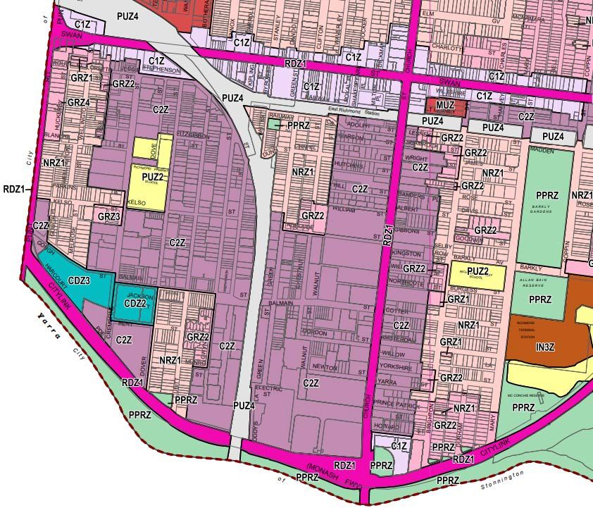
A zoning map is provided at Figure 4.
The study area for Cremorne encompasses two distinct areas, the commercial area and the
residential area. The commercial area is characterised by industrial heritage juxtaposed with
more recent office development of 7-14 storeys dispersed throughout the precinct. This area
is larger than the area bound by the orange border in the figure below.
Cremorne also includes three pockets of residential zoned land, largely comprising heritage,
low-rise terraced housing, as well as a small number of large mixed-use developments that
border the southwest corner of the precinct. Development is largely replacement dwellings
and residential extensions.
The study area, to which the Parking Overlay review applies, is limited to land zoned
Commercial 2 (C2Z) and Comprehensive Development (CDZ) within the study area boundary.
Figure 4: Cremorne Zoning Map
G28313R-01C 22Parking Controls Review Cremorne Enterprise Precinct
5.2. Regional Context
The Cremorne Enterprise Precinct is located within inner Melbourne and in close proximity to
the Melbourne CBD (less than 2km away) and a number of significant Activity Centres. Its
location relative to the central city area is shown in the figure below. Notably, Cremorne is a
similar distance to the CBD as Fishermans Bend, Arden/Macaulay and the northern areas of
Parkville while in many ways it is also better connected to the CBD via Richmond Station (and
the numerous metropolitan services this station offers).
Cremorne
Figure 5: Cremorne's location relative to the central city (Source: Plan Melbourne)
G28313R-01C 23Parking Controls Review Cremorne Enterprise Precinct
The Cremorne Enterprise Precinct is bound by the Swan Street Activity Centre to the north.
The Chapel Street Major Activity Centre is also located to the direct south of the precinct.
Key land uses in the vicinity of Cremorne include:
• Yarra Park/Melbourne Cricket Ground – located on the north-west of Cremorne,
• Olympic Park Precinct – located adjacent Cremorne to the west,
• Melbourne High School – located 200m south of Cremorne,
• Melbourne Girls Grammar – located 250m south-west of Cremorne,
• Royal Botanical Gardens – located 300m west of Cremorne, and
• Epworth Richmond – located 1km north of Cremorne.
5.3. Local Context
Land use within the Cremorne Enterprise Precinct consists of a wide variety of retail,
commercial, office, industrial and residential land uses. The Cremorne Enterprise Precinct
also includes the Kangan Institute (PUZ2 Public Use Zone – Education).
Richmond Station is the key transport node located on the periphery of Cremorne, however
East Richmond Station and South Yarra Station are both within a walkable distance of
Cremorne. Road-based tram and bus services operate along the arterial roads bordering the
precinct.
The availability of these everyday services and amenities means that the Cremorne Enterprise
Precinct already meets many of the characteristics that define the 20-minute neighbourhood
described in Plan Melbourne (see Section 4.1).
Cremorne is becoming a key destination for local and global high technology companies. The
suburb encompasses residential neighbourhoods nestled amongst the rapidly changing
commercial areas.
The figure below identifies the general land use patterns in Cremorne, including the 11 large
key employers and the key features of the transport network servicing the area.
G28313R-01C 24Parking Controls Review Cremorne Enterprise Precinct
Figure 6: Key Attributes Map of Cremorne (Source: Cremorne Issues and Opportunities Paper, 2019)
5.4. Review of Transport Network
5.4.1. Road Network
Cremorne is characterised by its unique and constrained road network. The suburb is
effectively bound in each direction by Arterial Roads/Freeways:
• Swan Street to the north.
• Church Street to the east (although part of the area included within the overlay is on the
east side of Church Street).
• Citylink to the south.
• Punt Road to the west.
Furthermore, the Yarra River to the south (and Citylink) forms a barrier to local vehicle and
pedestrian movement to the south, with the only two crossing points being at Punt Road and
Church Street.
All of these arterial roads are highly congested inner-city arterials. The table sets out the
configurations and daily traffic volumes carried by these roads
G28313R-01C 25Parking Controls Review Cremorne Enterprise Precinct
Table 1: Arterial Road Traffic Volumes (Source: Department of Transport Open data, 2020)
Road Name Configuration/Notes Average Annual Daily
Traffic Volume
Punt Road 3 or 4 traffic lanes in each direction 55,000
(between Citylink and Swan Street)
Citylink Freeway link 88,000
(between Punt Road and Church No access except for outbound on-ramp at
Street) Cremorne St and outbound off-ramp at Church
Street
Swan Street 4 lane arterial road 18,000
(between Lennox Street and Punt Kerbside lanes typically used for on-street
Road) parking, outside of peak hour Clearways
Centre lanes accommodate tram tracks
Church Street Effectively a 2 lane arterial road 18,000
(between Citylink and Swan Street) Kerbside lanes typically used for on-street
parking (no Clearways)
Bicycle lane
Centre lanes accommodate tram tracks
Access to the arterial road network from Cremorne is also subject to physical constraints.
These constraints are summarised at Figure 7 and discussed below.
• To the north, the only location where full access is provided is at Cremorne Street.
Wellington Street offers a left-out only access. The Lilydale/Belgrave/Alamein/Glen
Waverley rail line forms a barrier for other local roads connecting to Swan Street.
• To the east, Balmain Street is the only location where traffic signals are provided. While
there are more local road connections to Church Street (in comparison to other
directions), many of these are narrow laneways or one-way streets that have very limited
capacity to carry traffic.
• To the south, Citylink and the Yarra River block local movement. Cremorne Street provides
a connection to the outbound direction of Citylink towards the Monash Freeway and
south-eastern suburbs. Travelling inbound, drivers can arrive via Punt Road, then use
Swan Street and Cremorne Street to enter the precinct.
• To the west, access to Punt Road is highly controlled and where provided, limited to left-
in/left-out movements. Travelling to the north away from Cremorne using Punt Road is
reliant on Cremorne Street and Swan Street. To arrive from the south along Punt Road
relies on turning right into Swan Street and then right again into Cremorne Street, or
alternatively using Church Street.
G28313R-01C 26Parking Controls Review Cremorne Enterprise Precinct
Wellington St Left-
in/Left-out since
No vehicle access
late 2019
over rail line
No vehicle
access to
Punt Rd
Only two road links
across rail line
Figure 7: Existing Access Constraints (Source: Cremorne Traffic Assessment, DoT/MRPV)
Due to the local road layout and traffic management, Cremorne is primarily accessed via the
higher order local roads, which are Cremorne Street and Balmain Street. Both of these roads
have signalised intersections with the external Arterial Road network and facilitate access to
the lower order roads within Cremorne.
G28313R-01C 27Parking Controls Review Cremorne Enterprise Precinct
Figure 8 sets out the daily traffic volumes of key streets within the local road network and
highlights the reliance on the Cremorne Street/Balmain Street link through the precinct.
Figure 8: Existing Daily Traffic Volumes (Source: Cremorne Traffic Study 2019, DoT/MRPV)
Cremorne Street is a higher order Council road which is aligned in a north-south direction
from Swan Street in the north to Citylink in the south. The road carriageway generally
provides kerbside parking on both sides of the road, while also being wide enough to facilitate
two-way traffic flow at the same time.
Line marking (bicycle symbols) signifies that Cremorne Street is a shared road with bicycles,
although no formal bicycle lane is provided.
G28313R-01C 28Parking Controls Review Cremorne Enterprise Precinct
A signalised intersection is provided at the intersection with Swan Street which facilitates fully
directional movement to/from Swan Street. At the intersection with Citylink, movement is
restricted to left out from Cremorne Street.
Balmain Street is a higher order Council road, which is orientated in an east-west direction
from Church Street in the east to Cremorne Street in the west. To the east of the overhead
railway bridge, the road is wide enough to accommodate parking on each side of the road and
simultaneous two-way traffic flow. The road narrows to the west of the railway bridge and
parking is restricted on the south side of the carriageway by ‘No Stopping’ restrictions, which
allows for two-way traffic flow to be maintained.
Line marking (bicycle symbols) signifies that Balmain Street is a shared road with bicycles,
although no formal bicycle lane is provided.
A signalised intersection is provided at the intersection with Church Street which facilitates
fully directional movement to/from Balmain Street.
Internally, the street network is defined by a dense network of local streets. These are largely
narrow streets with limited road reserve widths. Many of these streets operate in a one-way
direction. The road carriageways have generally been maximised and on-street parking is
provided wherever possible. The walking environment in most of these streets is poor as a
consequence of the narrow verges available. Many footpaths are obstructed by street
infrastructure (power poles, etc.); a consequence of the narrow verges. As a result, the
pedestrian amenity within many streets is low.
5.4.2. Capacity Limitations
A Cremorne Traffic Assessment was commissioned in June 2019 by Department of
Transport and Major Road Projects Victoria as part of the Streamlining Hoddle Street project.
The independent study was designed to develop a better understanding of how traffic moves
through the Cremorne area. The changes to the Punt Road/Swan Street intersection as part
of this project had implications on access to Cremorne, particularly:
• Changes to Swan Street, including making it one traffic lane in each direction at Cremorne
Street and reducing the length of the right turn lane into Cremorne Street.
• The limitation of Wellington Street to left-in/left-out movements only, increasing the
pressure on Cremorne Street to accommodate right turn movements (in and out of the
area).
This report identified the following high-level issues within the Cremorne area:
• The fragmented nature of industrial, commercial and residential land uses within the
precinct places a constraint on how road space is allocated
• Due to the nature of major arterial roads bounding Cremorne and the configuration of heavy
rail lines, Cremorne is not afforded the same level of access and permeability to that of
other inner-city precincts of a similar size.
• Limited opportunities exist to access and exit the precinct to the west of the railway line,
intensifying the use of the connecting roads and intersections with the arterial road
network.
G28313R-01C 29Parking Controls Review Cremorne Enterprise Precinct
The study identified that the Cremorne Street/Swan Street intersection was a key capacity
constraint, particularly for access to the areas of Cremorne that are west of the train line. The
traffic surveys of the report identified that delays of up to 11 minutes were recorded during
the PM peak hour for vehicles trying to exit Cremorne Street (although this delay is variable
and the ‘worst’ days are often linked to sporting and entertainment events in the area). The
report identified that these delays were due to a number of factors (as identified in the study):
• Capacity of the Cremorne Street and Swan Street signalised intersection.
• Pedestrian volumes crossing Swan Street (travelling to the Richmond Station) limiting the
ability for vehicles to turn left out of Cremorne Street.
• Queuing of traffic along Swan Street back from Punt Road, limiting ability for vehicles to
turn left out of Cremorne Street.
In the background is the already identified issue that this intersection is critical for
movements to and from the precinct from a network perspective due to the lack of alternative
routes to the north and west.
The surveys completed in this study found congestion at this intersection was not a
significant issue in the AM peak hour or on weekends.
The evidence statement of John Kiriakidis for the redevelopment of the key Richmond Malt
site in December, 2015 identified similar issues (Reference 15M1705200, dated 22nd
December, 2015). This report studied the existing conditions of the critical intersections of
Cremorne Street/Swan Street and Balmain Street/Church Street. This report identified similar
capacity issues with both of these intersections. These observations and analysis were
completed in 2015 and does not include the recent developments completed in the last 4-5
years. It should be noted that there have been no significant capacity improvement works at
these intersections since this report.
Surveys and observations by Traffix Group of the Balmain Street/Church Street intersection in
October, 2018 found that this intersection operated at an acceptable level in the AM peak hour
but was over-saturated in the PM peak hour, with queues in excess of 15-20 vehicles and
queues being unable to clear during each cycle of the traffic lights. Part of the issue was
continuous traffic queues on Church Street, limiting the ability of traffic to exit Balmain Street.
5.5. Sustainable Transport
5.5.1. Public Transport
Cremorne is well serviced by public transport services with train, tram and bus connections.
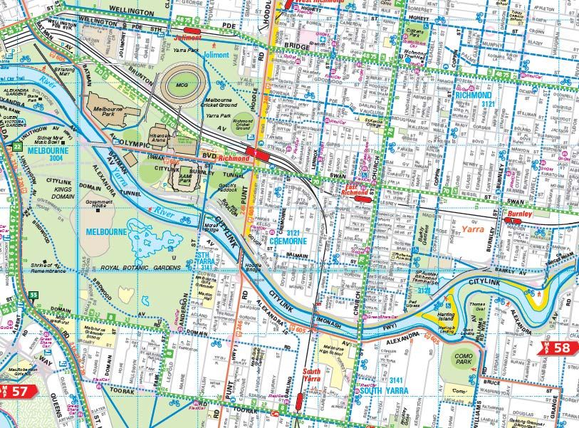
Figure 9 illustrates the public transport network that services Cremorne and surrounding
areas. The suburb is entirely within the Principal Public Transport Network map, as shown at
Figure 10.
G28313R-01C 30You can also read