Centurion CBD Development Framework - November 2014 - Tshwane
←
→
Page content transcription
If your browser does not render page correctly, please read the page content below
Centurion CBD Development Framework
             November 2014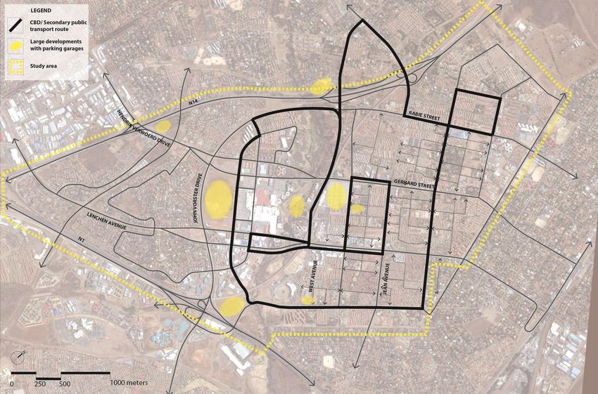
4.4 PUBLIC SPACE AND LANDSCAPING FRAMEWORK ......................................................................... 34
TABLE OF CONTENTS 4.4.1 Objectives ................................................................................................................ 34
1 INTRODUCTION ..................................................................................................................... 1 4.4.2 Public Spaces............................................................................................................ 34
4.4.3 Landscape and Cityscape Strategy ............................................................................ 35
1.1 PURPOSE AND AIMS OF THE CENTURION DEVELOPMENT FRAMEWORK ............................................... 1 4.5 URBAN BLOCK AND BUILT FORM GUIDELINES ............................................................................ 45
1.2 REPORT STRUCTURE ............................................................................................................ 1 4.5.1 Objectives ................................................................................................................ 45
1.3 STUDY AREA ...................................................................................................................... 1 4.5.2 Built Form Strategy .................................................................................................. 45
2 STRATEGIC ASSESSMENTS...................................................................................................... 2 4.5.3 Urban Block and Building Form Principles.................................................................. 45
4.5.4 Development Control................................................................................................ 48
2.1 CONTEXT .......................................................................................................................... 2
2.2 SUMMARY OF THE URBAN PERFORMANCE ASSESSMENTS ............................................................... 3 5 ESTIMATED CAPITAL COSTS.................................................................................................. 51
2.2.1 Thrust: Improving Accessibility, Connectivity and Efficiency (Access) ............................ 4 5.1 QUANTIFICATION OF CENTURION CBD GROWTH TO 2020............................................................ 51
2.2.2 Improve and Enhance Environmental Quality, Safety and Security (Vitality) ................. 4 5.2 IMPLEMENTATION APPROACH ............................................................................................... 51
2.2.3 Establishing a sense of belonging Identity and dignity (Sense) ..................................... 5 5.3 IMPLEMENTATION COSTS ..................................................................................................... 52
2.2.4 Making space for lifestyle needs and growth (Fit) ....................................................... 5 5.4 STORM WATER INFRASTRUCTURE AND FLOOD RISK MANAGEMENT: SUMMARY OF ESTIMATED COSTS ....... 53
2.2.5 People Development and Involvement (Control).......................................................... 5 5.5 ELECTRICITY: SUMMARY OF ESTIMATED COSTS .......................................................................... 57
2.3 GROWTH ESTIMATES ........................................................................................................... 5 5.6 WATER AND SANITATION COSTS ............................................................................................ 58
2.3.1 Growth Assumptions .................................................................................................. 5 5.6.1 Water Costs ............................................................................................................. 58
3 CONCEPTUAL FRAMEWORK FOR DEVELOPMENT ................................................................... 9 5.6.2 Sanitation Costs ....................................................................................................... 59
5.7 ENVIRONMENTAL .............................................................................................................. 60
3.1 ROLES FOR THE STUDY AREA .................................................................................................. 9 5.8 ENVIRONMENTAL AUTHORISATIONS ........................................................................................ 61
3.2 DEVELOPMENT PRINCIPLES .................................................................................................... 9 5.9 TRANSPORTATION COST ESTIMATES ........................................................................................ 63
3.3 VISION ............................................................................................................................. 9 5.9.1 Infrastructure Improvements linked to the ICC........................................................... 63
3.4 SPATIAL CONCEPTS .............................................................................................................10 5.9.2 Infrastructure Improvements linked to Symbio City.................................................... 63
3.4.1 Connecting into the Wider Metropolis and surrounding region ...................................10 5.9.3 Infrastructure Improvements linked to Public Transport – BRT ................................... 63
3.4.2 Providing Adequate Capacity for Growth in an Integrated Manner .............................10 5.9.4 Infrastructure Improvements linked to Public Transport – NMT.................................. 63
3.4.3 Creating a more Responsive and Human Scaled Urban Environment ..........................10 5.9.5 Infrastructure Improvements for parking................................................................... 63
4 SPATIAL DEVELOPMENT FRAMEWORKS................................................................................14 5.9.6 Infrastructure Improvements linked to the ICC........................................................... 63
5.9.7 Infrastructure Improvements linked to Symbio City.................................................... 63
4.1 LAND USE FRAMEWORK ......................................................................................................14 5.9.8 Infrastructure Improvements linked to Public Transport – BRT ................................... 64
4.1.1 Land Use Objectives ..................................................................................................14 5.9.9 Infrastructure Improvements linked to Public Transport – NMT.................................. 64
4.1.2 Land Use Categories .................................................................................................14 5.9.10 Infrastructure Improvements linked to Public Transport – NMT ............................. 64
4.2 TRANSPORTATION FRAMEWORK .............................................................................................17
4.2.1 Objectives.................................................................................................................17 6 APPENDICES ......................................................................................................................... 65
4.2.2 Enhancing the Access and Circulation Networks .........................................................17 6.1 APPENDIX 1: STRATEGIC INTEGRATED ASSESSMENT ..................................................................... 65
4.2.3 Regional Road Access Network..................................................................................17 6.2 APPENDIX 2 : TRANSPORT AND INFRASTRUCTURE MASTER PLANS.................................................... 71
4.2.4 Local Circulation Network .........................................................................................18 6.2.1 Appendix 2A : Traffic Engineering Report .................................................................. 71
4.2.5 Public Transport........................................................................................................19 6.2.2 Appendix 2B : Water and Sanitation Report............................................................... 71
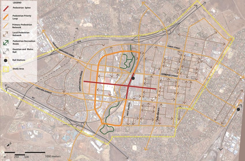
4.2.6 Non - Motorised Transport (NMT) .............................................................................19 6.2.3 Appendix 2C : Storm Water and Flood Management Report ...................................... 71
4.2.7 Parking .....................................................................................................................20 6.2.4 Appendix 2D : Electricity Reports............................................................................... 71
4.2.8 Traffic Safety ............................................................................................................21 6.2.5 Appendix 2E : Geotechnical Report............................................................................ 71
4.2.9 Transport Demand Management ..............................................................................21
4.2.10 Intelligent Transport Systems ................................................................................21
4.3 ENVIRONMENTAL FRAMEWORK..............................................................................................27 Note: cover aerial photograph sourced from www.aurecongroup.com
4.3.1 Objectives.................................................................................................................27
4.3.2 Open Space Assets ....................................................................................................27
4.3.3 The Open Space Framework ......................................................................................27
Centurion CBD Master Plan – Development Framework – December 2013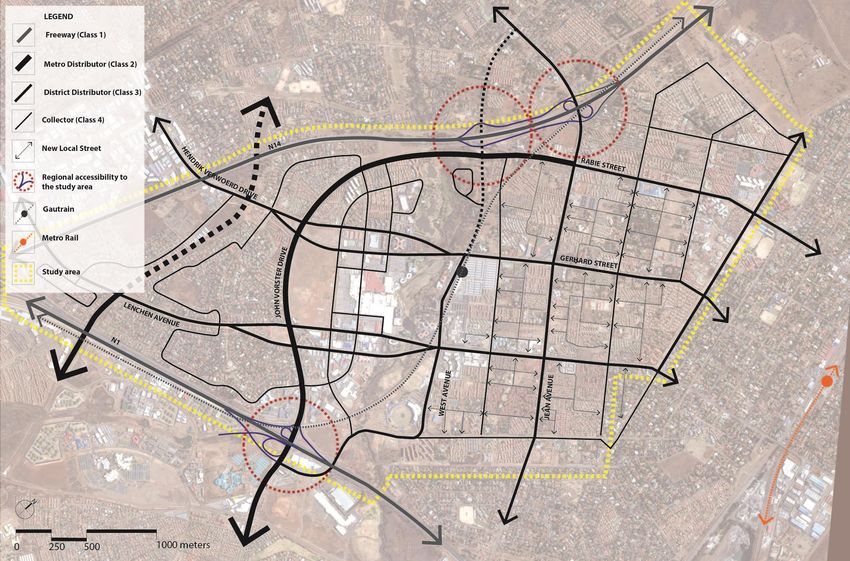
are secondary access routes through centurion. The routes should become tree lined boulevards
LIST OF FIGURES                                                                                                                                      with low shrubs and groundcovers along property boundaries. ...................................................... 40
Figure 1: Locality Plan ..................................................................................................................... 1      Figure 30: Lenchen Avenue: Conceptual sketch of street upgrading showing tree lined boulevard and
Figure 2: Study Area ....................................................................................................................... 2       potential NMT facilities ................................................................................................................. 41
Figure 3: The Economic Triangle...................................................................................................... 3              Figure 31: Impressions : Improve the pedestrian environment with tree planting, and canopies and
Figure 4: Region 4 Spatial Development Framework ........................................................................ 3                          colonnades that edge the civic space ............................................................................................. 41
Figure 5: Urban Block Restructuring Concept..................................................................................11                      Figure 32: Impressions : Reinforce the identity or sense of place in the proposed Centurion’s civic
                                                                                                                                                     space with landscape elements that reflect Centurion’s riverside character.................................... 41
Figure 6: Regional Spatial Structure ................................................................................................12
                                                                                                                                                     Figure 33: Impressions : Emphasise the civic space with a key landmark building or landscape feature
Figure 7: CBD Spatial Concept ........................................................................................................13             ..................................................................................................................................................... 42
Figure 8: Land Use Framework .......................................................................................................16               Figure 34: Impressions : Facilitate public activity with hard surfacing, street furniture and trees/
Figure 9: Interchange Improvements..............................................................................................18                   planting ........................................................................................................................................ 42
Figure 10: Intersection Upgrading ..................................................................................................18               Figure 35: TICC: Conceptual sketch of the African Gateway Precinct landscaped civic space with trees
Figure 11: Examples of Pedestrian Crossing Improvements .............................................................20                              and colonnaded building edge, including South Street as part of the overall public space ............... 42
Figure 12: Access and Road Circulation Network ............................................................................22                        Figure 36: “Bazaar” Route within Gautrain Station Precinct: Conceptual sketch of pedestrian route
                                                                                                                                                     showing overlooking of the space with an active ground floor and pedestrian focus ....................... 43
Figure 13: Public Transport Network ..............................................................................................23
                                                                                                                                                     Figure 37: Public Space and Landscaping Framework ..................................................................... 44
Figure 14: Proposed IRPTN Alternatives 1-3....................................................................................24
                                                                                                                                                     Figure 38: Perimeter buildings enclose streets and spaces and allow for active edges and overlooking
Figure 15: NMT Framework............................................................................................................25
                                                                                                                                                     ..................................................................................................................................................... 46
Figure 16: Parking Framework........................................................................................................26
                                                                                                                                                     Figure 39: Perimeter blocks edging the street with internal communal courtyards – accessible from
Figure 17: Open Space System .......................................................................................................33               both sides ..................................................................................................................................... 46
Figure 18: Moses Mabhida Stadium, Durban ..................................................................................36                        Figure 40: Wrap larger buildings with smaller units to create an active frontage ............................. 46
Figure 19: Impression of Urban tree lined recreation route.............................................................36                            Figure 41: Global landmarks terminating views .............................................................................. 47
Figure 20: Impression of Circular recreation route ..........................................................................37                      Figure 42: Local landmarks – Unitas Hospital and Gautrain Station ................................................. 47
Figure 21: Impression of Landscaped pedestrian route edging park ................................................37                                  Figure 43: Keep well proportioned height ratios relative to type of street ....................................... 48
Figure 22: South Street between Heuwel/ Embankment Road: Conceptual Sketch indicating NMT                                                            Figure 44: Built Form Guidelines .................................................................................................... 49
upgrading ......................................................................................................................................37
                                                                                                                                                     Figure 45: Centurion CBD Vision .................................................................................................... 50
Figure 23: Jean Avenue: Conceptual sketch of street upgrading showing activity streets with active
ground floor and pedestrian focus .................................................................................................38
Figure 24: Impression of West Avenue special landscape treatment - wide tree lined pavement and
active groundfloor .........................................................................................................................38
Figure 25: Impression of West Avenue (north) running along Centurion Park -reinforce riverine
character with an avenue of 'feature trees’ along the park-side with a wide pavement ...................39
Figure 26: Extract of conceptual layout of West Avenue between Lenchen Avenue (south) and
Gerhard Street (north) emphasis on pedestrian/ cycle priority with an avenue of trees, pedestrian
boulevard, defined public spaces ...................................................................................................39
Figure 27: West Avenue: Conceptual sketch of street upgrading showing two way traffic with
pedestrian boulevard , two way cycle route and active ground floor edge onto West Avenue .........39
Figure 28: Tree lined boulevards establish a strong identity and improve the micro climate ............40
Figure 29: John Vorster Drive: Conceptual sketch of street upgrading showing major tree lined
boulevard and potential NMT facilities/ promenadeHendrik Verwoerd Drive and Lenchen Avenue

Centurion CBD Master Plan – Development Framework – December 2013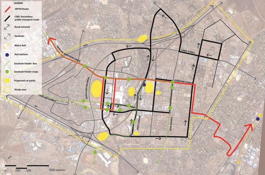
Table 27 : SCENARIO ONE: Includes normal incremental growth + additional development
LIST OF TABLES                                                                                                                                          applications not accounted for in CoT modelling for all sectors ...................................................... 61
Table 1 : Urban Performance Dimensions (Kevin Lynch, Good City Form) ......................................... 4                                        Table 28 : SCENARIO TWO: Includes Scenario One + African Gateway Precinct ............................... 61
Table 2 : Base Year 2013 Scenario – Existing Development Estimnate (Phase One) ........................... 6                                            Table 29 : SCENARIO THREE: Includes Scenarios One and Two + Symbio City .................................. 62
Table 3 : Phase Two Scenario – 2015 ............................................................................................... 7
Table 4 : Phase Three Scenario – 2020............................................................................................. 7
Table 5 : Phase Four Scenario – Ultimate Development ................................................................... 8                              Abbreviations
Table 6 : Roles for Study Area ......................................................................................................... 9
                                                                                                                                                        CBD        Central Business District
Table 7 : Development Principles .................................................................................................... 9
                                                                                                                                                        CoT        City of Tshwane
Table 8: Parking garages ...............................................................................................................20
                                                                                                                                                        FAR        Floor Area Ratio
Table 9: Gautrain parking ..............................................................................................................20
                                                                                                                                                        ICT        Information and Communications Technologies
Table 10: Parking areas .................................................................................................................21
                                                                                                                                                        IRT        Integrated Rapid Transit
Table 11 : Open Space System Elements.........................................................................................27
                                                                                                                                                        IRPTN      Integrated Rapid Public Transport Network
Table 12 : Open Space System Elements in the Study Area..............................................................28
                                                                                                                                                        NMT        Non Motorised Transport
Table 13 : Open Space Character and Development Interventions ..................................................29
                                                                                                                                                        SDF        Strategic Development Framework –
Table 14 : Summary of Costs for Growth Scenarios .........................................................................52
                                                                                                                                                        TOD        Transit Oriented Development
Table 15 : Upgrading of Stormwater Infrastructure in Centurion based on Expected Development in
Identified Blocks – September 2013 (1) 2020 Scenario (includes incremental growth plus backlog) .53
Table 16 : Upgrading of Stormwater Infrastructure in Centurion based on Expected Development in
Identified Blocks – September 2013 (2) 2020 Scenario + African Gateway Precinct (includes
incremental growth plus backlog) ..................................................................................................54
Table 17 : Upgrading of Stormwater Infrastructure in Centurion based on Expected Development in
Identified Blocks – September 2013 (2) 2020 Scenario + African Gateway Precinct + Symbio City
(includes incremental growth plus backlog) ....................................................................................55
Table 18 : Cashflow and Cost Summary for Rehabilitation of Centurion Lake based on Report by BKS
(2008) – All Scenarios (1, 2 and 3) ..................................................................................................56
Table 19 : Implementation Plan for the Main Electrical Networks: 2014/15 to 2019/2020 Financial
Years .............................................................................................................................................57
Table 20 : WATER SUPPLY SCENARIO 1 (Listing and costing of projects to implement requisite
service) Estimates only ..................................................................................................................58
Table 21 : WATER SUPPLY SCENARIO 2 (Listing and costing of projects to implement requisite
service) .........................................................................................................................................58
Table 22 : WATER SUPPLY SCENARIO 3 (Listing and costing of projects to implement requisite
service) .........................................................................................................................................58
Table 23 : SANITATION SCENARIO 1 (Listing and costing of projects to implement requisite service) 59
Table 24 : SANITATION SCENARIO 2 (Listing and costing of projects to implement requisite service) 59
Table 25 : SANITATION SCENARIO 3 (Listing and costing of projects to implement requisite service) 59
Table 26 : SECTOR PROJECTS (Listing and costing of projects to implement requisite service) ..........60

Centurion CBD Master Plan – Development Framework – December 2013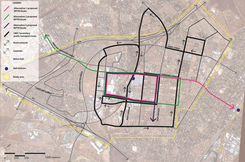
Section Two Strategic Assessment – Summarises the work of the planning team around the status
1 Introduction quo of the study area and integrates it into a strategic assessment of the issues and needs for the
study area.
1.1 Purpose and Aims of the Centurion Development Framework
Section Three Vision and Conceptual Framework for Development – Outlines the vision, roles, key
The Centurion Metropolitan Node is currently facing a significant increase in development pressures development principles and concepts required to direct development in the study area.
and interest as a result of its very high locational advantages within the Johannesburg, Tshwane, and
Section Four Development Frameworks – Describes the growth scenarios anticipated for the area,
Ekurhuleni economic triangle.
as well as, the guiding frameworks for Environmental Management, Land Use and Activities, Access
In the case of the Centurion CBD specifically the City of Tshwane (CoT) recognises the need to and Circulation, Public Space and Landscape.
urgently review its planning as part of the Centurion Metropolitan Node planning across a number
Section Five Appendices – Strategic Integrated Assessment and Infrastructure Master Plan reports.
of built environment sectors so that development can be unblocked in a prioritised and phased
manner in accordance with a clearly articulated development vision for the period up to 2055.
1.3 Study Area
Moreover, the review is to also assess the implications of two key large scale development initiatives
(i.e. the CoT driven African Gateway Precinct which consists of the Tshwane International The Study Area as shown in Figure 1 and Figure 2, is very well located within the economic triangle
Convention Centre and Governmental Precinct, and the privately driven Symbio City proposals). of Johannesburg, Tshwane and Ekurhuleni and includes a triangular area of land approximately 1000
hectares in extent and which is bordered by the N1, the N14, and Clifton Avenue. The area forms the
The CoT has also recognised that the CBD area, whilst still viable as a business and residential area
Central Core of the Centurion Metropolitan Node as identified in both the Tshwane Metropolitan
has lost its identity, human scale and overall townscape and urban quality. The significant
SDF and the Tshwane Regional 4 SDF.
development pressures thus represent a very real opportunity to restructure the urban fabric of the
CBD and to upgrade it into a high quality metropolitan business destination and high performance
urban living area.
This document consolidates the key outcomes of a suite of Infrastructure Master Plans into an
integrated development framework which articulates a longer term vision for the study area in
accordance with the vision of higher levels of planning of CoT.
As such, this framework, in conjunction with the Infrastructure Master Plans, provides the following:
a vision for the study area that directs future development so as to enable the creation of a
more sustainable urban destination of choice
guidelines for land use mix, distribution and intensity, as well as, for built form, public space and
landscape that will lead to a high quality and a high performance urban environment
an indication of short and medium term investment in infrastructure (i.e. roads, water ,
sanitation, electricity, storm water and flood risk) to accommodate anticipated urban
development
a “tool” for managing day to day development applications from the private sector in
accordance with the vision
an assessment of the implications of the proposed large scale development interventions of the
African Gateway Precinct and Symbio City on transportation, water, sanitation, electricity,
storm water and flood risk management infrastructure
1.2 Report Structure
Section One Introduction – Describes the study area and purpose and aims of the Centurion
Development Framework. Figure 1: Locality Plan
Centurion CBD Master Plan – Development Framework – December 2013 Page 1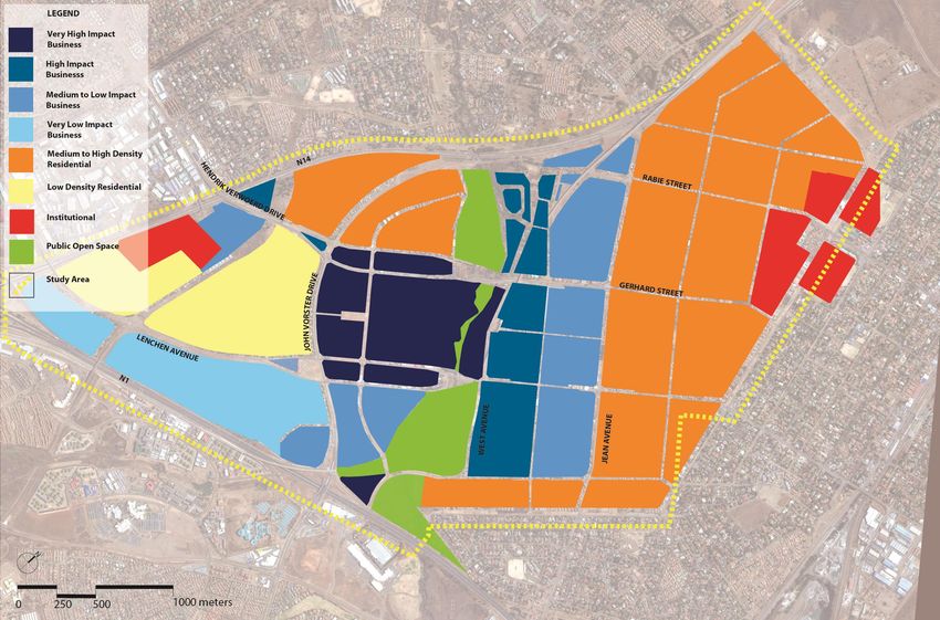
The study area contains a number of discernable urban districts each of which display different
characteristics and each of which are in different stages of development.
2 Strategic Assessments
The following sections provide a summary of the results of the assessments done by the team and
Zwartkop – The south western district is predominantly low density special residential with a
highlight the important quantitative and qualitative informants that have been used to prepare the
mix of zones accommodating low order commercial and community uses at the major
Development Framework.
entrances to this portion of the site. Development is in a regular suburban pattern with a clear
structure with little change currently occurring.
Die Hoewes – The north eastern district is an old agricultural small holdings area and displays a 2.1 Context
very mixed, irregular and suburban pattern of development indicating a precinct in significant
transition with significant potential for further rezoning, upgrading and development to occur. The Centurion CBD forms the business core of the Region 4 Metropolitan Node identified in both the
Tshwane Metropolitan Spatial Development Framework as well as the Region 4 Spatial Development
Centurion CBD – The original historic CBD of the town of Centurion is a mixed use district
Framework. The node is centred on the original town and business centre of the old town of
centred on a very large shopping centre and contains a mix of retail, offices, light/service
Centurion and it accommodates and supports the expanding high technology cluster that has
industrial and public open space. The spatial structure of the area is reasonably regular, but is
established in this highly accessible location within the “economic triangle” of Johannesburg,
suburban in character, significantly car oriented and displaying insular clusters of single use
Tshwane and Ekurhuleni.
zones separated by wide and “spaceless” road corridors.
Figure 3 and Figure 4 below indicate the location of the node in the economic triangle and in Region
4 of the CoT.
The key regional pressures driving development in the study area include:
Increasing urban and regional growth patterns and forces driven by significantly high locational
advantages, rapidly emerging high technology and logistics industry and related financial and
business service sectors resulting in numerous and varied business and higher density
residential development applications.
Collective and strategic impacts of urban and regional scaled social, environmental and
economic dynamics induced by policy shifts and / or associated large scale development
programmes and infrastructural interventions and developments (e.g. Gautrain, BRT, housing,
environmental management, spatial restructuring).
The need to respond to two key large scale development initiatives generated by the improving
locational advantages of the Node (i.e. the CoT driven African Gateway Precinct consisting of
the Tshwane International Convention Centre and Governmental Precinct, and the privately
driven Symbio City project including the Zwartkop x 28 proposal).
Strategic development management imperatives motivated by climate change scenarios,
increased social awareness and pressure on the use of, and management costs of,
environmental resources and infrastructure, and the recognition by city managers of the need
to create more “environmental shock” resistant / resilient human settlements.
The increasing recognition of the need to restructure and reshape urban areas into more
integrated, more responsive and more competitive urban working, living and playing
environments.
In addition to the above it has been recognised in current planning reviews within the metropolitan
region that the Centurion Node has the potential to be one of the most accessible locations within
Figure 2: Study Area the economic triangle that still has significant expansion potential to accommodate growth, but
more significantly to do so in a manner which responds to the significant policy imperatives calling
for more sustainable, “smart” and innovative urban development responses.
Figure 3 and Figure 4 indicate the excellent location of the study area within the Gauteng “economic
triangle” and the extent of mixed use development proposed around the Centurion CBD.
Centurion CBD Master Plan – Development Framework – December 2013 Page 2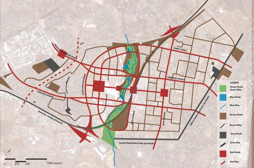
The following extract for the Regional SDF for Region 4 which describes the node within which the
                                                                       CBD falls and as such informs the future planning of the CBD.
                                                                       “Metropolitan Nodes - these are primary nodes of the highest order. These nodes accommodate the
                                                                       highest degree of service specialisation and offer the widest range of services. Often, metropolitan
                                                                       nodes will have regional/provincial significance. In the context of Tshwane, Metropolitan nodes are
                                                                       those nodes within the City benefiting from the investment of the private sector. Equally important is
                                          Centurion                    that these nodes serve as economic hubs and focal points for employment opportunities. The role of
                                                                       the public sector in such nodes is to manage the range of growth, provide infrastructure in line with
                                                                       the growth management plan and maintain the urban environment. Such localities are also where
                                                                       the most extensive land use rights, including densities, are likely to be supported, also in line with the
                                                                       growth management strategy.”

                                                                       2.2     Summary of the Urban Performance Assessments
                                                                       The quality and performance of the CBD as a living environment has been identified as wanting. This
                                                                       is a manifestation of decreasing regional accessibility, pressure on the capacity of infrastructure and,
                                                                       equally as important, a significant decrease in the environmental quality of the area evidenced by
                                                                       car dominance and poor pedestrian environment, degraded natural environment of the river,
                                                                       increasing development of gated business and residential communities and poor urban spatial
                                                                       quality.

Figure 3: The Economic Triangle                                        A set of urban performance dimensions, developed by theorist and urban planner Kevin Lynch in his
                                                                       book “Good City Form”, and described below in Table 1, was used to structure an integrated
                                                                       workshop session with a cross section of the CoT staff in order to assess how the study area was
                                                                       performing as an urban area, and to provide a basis for future planning and development initiatives
                                                                       and investment. The dimensions were used to structure debate so that cross cutting and related
                                                                       issues are grouped together and to break away from the usual linear sectoral assessments. The key
                                                                       issues emanating from the workshop are summarised below, whilst the full assessment is contained
                                                                       within the Appendices.

                                                           Centurion

Figure 4: Region 4 Spatial Development Framework

Centurion CBD Master Plan – Development Framework – December 2013                                                                                                        Page 3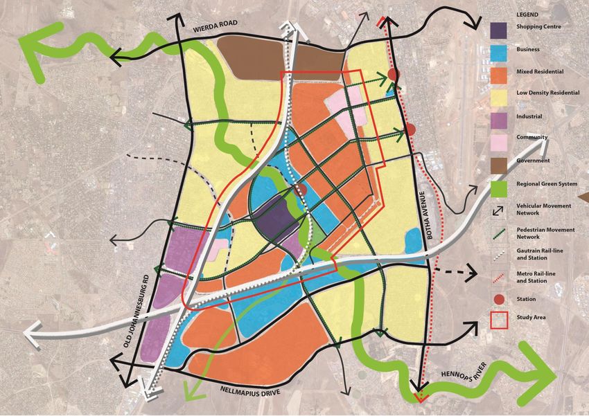
Table 1 : Urban Performance Dimensions (Kevin Lynch, Good City Form) Enable and reinforce the Transit Oriented Development initiatives of the Gautrain
and BRT
Improve Urban Connectivity
Improve internal circulation and access to local level nodes, services and facilities
Consolidate Public Transport routes and facilities that traverse the area
Increase and improve pedestrian linkage networks and infrastructure within study
area and to immediately adjacent residential areas and areas of social and
economic opportunity
Improve Accessibility to services and facilities
Establish an increased level of mixed land uses in high accessibility locations
Upgrade and increase provision of access to social facilities
Increase the number and capacity of, and rationalise the parking infrastructure and
systems serving the Core
Reduce the dominance of the car
Rationalise public transport routing
Prioritise pedestrian traffic safety needs at intersections and around public
transport nodes
Enhance the attractiveness and convenience of the pedestrian environment
Reconfigure / landscape open parking areas
2.2.2 Improve and Enhance Environmental Quality, Safety and Security
(Vitality)
Protect, rehabilitate and Enhance Environmental Assets
Rehabilitate the Hennops River as ecological corridor
Protect and integrate environmental assets and enhance their ability to contribute
to eco services delivery
Increase the capacity of the green assets of the area to improve air quality
Improve water quality in the Hennops River including the lake
Maintain and Improve Basic Services
Improve refuse management in the River catchment
Upgrade water reticulation infrastructure and management in areas with high
2.2.1 Thrust: Improving Accessibility, Connectivity and Efficiency (Access) levels of sinkhole risk
Establish improved Regional Access and Integration Promote More Responsive Building Typologies and Forms
Increase and improve regional vehicular access off the N1 and N14 to the CBD Core Encourage use of perimeter block buildings that provide active building frontages on
Increase/improve vehicular and pedestrian linkage and connectivity between the public environment
study area and immediately adjacent areas
Centurion CBD Master Plan – Development Framework – December 2013 Page 4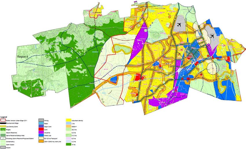
Encourage building form and designs that ensure overlooking of public spaces Provide for a range of housing types and costs
(defensible space) Promote higher density residential development
Encourage use of buildings that define public and private space clearly
Increase social facilities
2.2.3 Establishing a sense of belonging Identity and dignity (Sense) Provide more local level open space and recreation
Provide opportunities for additional schools
Review and strengthen the spatial structure of the study area
Utilise more responsive Building Typologies
Identify and Strengthen the roles and functions of districts and precincts
Promote the establishment of land uses and activities which contribute to, and
2.2.5 People Development and Involvement (Control)
compliment the vision and roles of the node and its districts, precincts and
neighbourhoods Enhance Coordination and Cooperation between Stakeholder Groups
Establish, Consolidate and / or reinforce a diversity of local level activity nodes
throughout the area Coordinate existing stakeholder initiatives and energies.
Involve stakeholder groups in the current planning process
Establish and enhance Imageability and Legibility
Build Management Capacity within the stakeholder community
Celebrate key gateways into the area i.e. off N1 and N14 Gautrain Station etc.
Upgrade and enhance the quality public space in nodes, corridors and Promote the establishment of Interest based groups e.g. UIP’s
neighbourhoods Link communities and businesses to surrounding and metropolitan business
Protect and celebrate natural and manmade (cultural) Landmarks Environmental Management Training and Education
Establish Identity a sense of belonging
2.3 Growth Estimates
Promote and/or create district, precinct and neighbourhood identity for the Core,
residential and recreation areas Three growth phases have been identified and quantified to generate estimated development yields
Encourage built form that contributes to street and neighbourhood identity within the study area for the immediate future and long term future. The estimated development
yields form the basis of the overall Development Framework for the Centurion Study Area in that
they are direct inputs to land use, transportation, water, sanitation, electricity and storm water
2.2.4 Making space for lifestyle needs and growth (Fit) modelling and master planning. The estimates also build in anticipated impacts of the two major
initiatives currently being contemplated by the CoT i.e. African Gateway Precinct and the
Accommodate urban growth patterns
development of Centurion Lake viz. Symbio City.
Accommodate estimated incremental growth in the CBD
Assess the implications of current large scale flagship initiatives 2.3.1 Growth Assumptions
Increase supply of functional Public Space The following assumptions were used to estimate growth in each of the phases and should be read
in conjunction with the drawings and tables below.
Enhance the quality and capacity of public space in Nodes and Corridors
Enhance visual and functional quality of streets and public spaces and establish Study Area – This is the area determined by CoT as the area of study for the Centurion Master
new public spaces Planning Initiative and is indicated in Figure 2 on page 2. It is acknowledged that the study area
might not overlap with existing or conventional planning zone boundaries for transport or the
Increase and improve Economic Spaces catchment boundaries for water and sanitation planning, and accordingly development yields
Promote a balanced mix of complimentary use and activities i.e. balanced have been organised into smaller more flexible spatial units i.e. town/city blocks. These can
community then be aggregated as required by respective sector planners.
Create Districts, Precincts and Neighbourhoods of discernable character
Minimise the potential adverse impacts of incompatible land uses and activities on
one another
Increase and enhance Housing Choice
Centurion CBD Master Plan – Development Framework – December 2013 Page 5
Blocks – These are city blocks determined by the planning team and which are invariably NOT Town Planning Zonings, but rather indicate the mix and intensity of development that
defined by major road corridors, natural features or study area boundaries and which each should be permitted in the future and are described in the Development Parameters Table.
contain a number of discrete subdivisions that accommodate, or could accommodate Suitable zonings will need to be identified and or created at a later stage by CoT.
development that will generate a floor area. The blocks do not include road areas. Residential Unit Yields – These have been calculated by dividing the portion of the floor area in
Floor Area Ratio’s (FAR’s) – Floor Area Ratios for each growth period differ in that each FAR’s a block that is anticipated to be residential by an average residential unit size which is
for each phase have tried to “build in” the existing FAR’s, new FAR’s as the CoT’s response to considered appropriate for that block (e.g. smaller residential unit size in denser urban areas
the need to densify development, as well as, to respond to the market demand for increased and larger unit sizes in the suburban areas).
floor area yields as property prices increase over time.
Land Use Categories – The mix and type of land uses will increase and diversify over time thus
generating a complex mix of land use in the area and in each Block (and indeed on each
subdivision). For purposes of generating development yields for each phase a set of land use
categories, each of which contain a mix of land uses and associated FAR’s that are considered
desirable for the area in the long term, have been identified. These Land Use Categories are
a) Base Year 2013 – Existing Development Estimate (Phase One)
Existing development estimates were calculated by applying the Floor Area Ratio’s (FAR’s) currently contained within the applicable Centurion Town Planning Schemes to the subdivisions that currently have
development on them. These yields were tested and “ground truthed” as far as possible with the Town Planning officials.
Table 2 : Base Year 2013 Scenario – Existing Development Estimnate (Phase One)
Vacant Land
High Impact
High Impact
Public Open
Grand Total
Low Impact
Low Impact
Institutional
Residential
Residential
Residential
Residential
Very Low
Medium
Medium
Business
Business
Business
Existing
Impact
Impact
Impact
Street
Space
Scenario 1 –
Existing
Density (FAR) 0.00 0.00-0.50 0.00 Various 0.40 0.40 0.03 0.25 0.50-1.20 0.60 0.50 -
Total Commercial
- 195 487 - - 142 030 382 620 - 48 645 311 466 12 501 4 024 1 096 774
Floor Area (m2)
Total Residential
- - - - 804 839 95 655 24 096 275 654 77 867 23 216 1 006 1 302 333
Floor Area (m2)
Total Floor Area
- 195 487 - - 946 869 478 275 24 096 324 299 389 333 35 717 5 030 2 399 107
(m2)
Total Residential
- - - - 8 048 957 80 1 378 779 232 10 11 484
Units
Total Block Area
1 623 338 472 060 789 868 1 105 116 2 367 175 1 195 687 803 205 1 297 194 369 918 59 529 10 060 10 093 147
(m2)
b) Phase Two – 2015
This phase consists of the estimated 2013 footprint plus the anticipated development yields that would be generated by current development applications within the area. FAR’s used are those that are
approved or are likely to be approved by the CoT for these applications.
Centurion CBD Master Plan – Development Framework – December 2013 Page 6Table 3 : Phase Two Scenario – 2015
Vacant Land
High Impact
High Impact
Public Open
Grand Total
Low Impact
Low Impact
Institutional
Residential
Residential
Residential
Residential
Very Low
Medium
Medium
Business
Business
Business
Existing
Impact
Impact
Impact
Street
Space
Scenario 2 – 2015
Density (FAR) 0.00 0.00-0.50 0.00-0.10 Various 0.40 0.40 0.03 0.25 0.50-2.00 0.60 0.50 -
Total Commercial
- 195 487 11 800 - 142 211 372 992 60 810 - 48 645 374 474 64 530 1 270 950
Floor Area (m2)
Total Residential
- - - - 805 863 93 248 112 933 19 123 275 654 93 619 16 132 1 416 571
Floor Area (m2)
Total Floor Area
- 195 487 11 800 - 948 074 466 240 173 743 19 123 324 299 468 093 80 662 2 687 521
(m2)
Total Residential
- - - - 8 059 932 1 129 64 1 378 936 161 12 660
Units
Total Block Area
1 623 338 472 060 789 868 759 141 2 370 185 1 165 600 289 571 637 428 1 297 194 527 439 161 324 10 093 147
(m2)
c) Phase Three – 2020
This phase consists of the yields from both the previous phases plus the anticipated yields from major development initiatives that are being entertained by the CoT at present (i.e. African Gateway Precinct and
Symbio City), as well as, normal incremental growth that can be anticipated to occur during the next seven years (i.e. infill on vacant land and densification of existing properties in response to infrastructure
upgrades in the area).
Table 4 : Phase Three Scenario – 2020
Existing Street
Institutional
Public Open
High Impact
High Impact
Grand Total
Low Impact
Low Impact
Residential
Residential
Residential
Residential
Very High
Very Low
Business
Business
Business
Business
Medium
Medium
Impact
Impact
Impact
Impact
Space
Scenario 3 – 2020
Density (FAR) 0.00 0.00-0.50 0.00-0.10 0.40 0.40 0.60 0.03 0.25 0.50-2.00 0.50 4.50 -
Total Commercial
- 195 487 11 800 143 420 374 898 92 260 - 51 261 976 375 144 120 591 291 2 580 914
Floor Area (m2)
Total Residential
- - - 812 716 93 725 171 339 19 123 290 475 244 094 36 030 147 823 1 815 324
Floor Area (m2)
Total Floor Area
0 195 487 11 800 956 136 468 623 263 599 19 123 341 736 1 220 469 180 150 739 114 4 396 238
(m2)
Total Residential
- - - 8 127 937 1 713 64 1 452 2 441 360 1 971 17 066
Units
Total Block Area
1 623 338 472 060 726 644 2 390 341 1 171 557 439 331 637 428 1 366 939 903 627 260 857 101 024 10 093 147
(m2)
Centurion CBD Master Plan – Development Framework – December 2013 Page 7d) Phase Four – Ultimate Development
This phase is an estimate of what the total long term development potential of the area could be, based on full development of all land according to a set of land uses and FAR’s that make provision for the
demand for increased development densities and mix of land use.
Table 5 : Phase Four Scenario – Ultimate Development
Institutional
Public Open
High Impact
High Impact
Grand Total
Low Impact
Low Impact
Residential
Residential
Residential
Very High
Very Low
Business
Business
Business
Business
Business
Medium
Medium
Existing
Impact
Impact
Impact
Impact
Street
Space
Scenario 4 –
Ultimate
Density (FAR) 0.00 1.00 0.10 2.00 0.40 0.50 0.60 0.30 0.30 1.00 9.00 -
Total Commercial
- 390 975 69 565 2 254 467 153 251 199 457 210 334 28 649 138 339 459 717 591 291 4 496 046
Floor Area (m2)
Total Residential
- - - 563 617 868 423 49 864 390 621 162 345 34 585 114 929 147 823 2 332 207
Floor Area (m2)
Total Floor Area
0 390 975 69 565 2 818 084 1 021 674 249 321 600 955 190 994 172 924 574 646 739 114 6 828 253
(m2)
Total Residential
- - - 5 636 8 684 499 3 906 811 173 1 149 1 971 22 830
Units
Total Sum of Block
1 623 338 390 975 726 644 1 409 042 2 554 185 498 643 1 001 592 636 646 576 412 574 646 101 024 10 093 147
Area (m2)
Centurion CBD Master Plan – Development Framework – December 2013 Page 8development with nature and ensuring a realistic level of resilience to effects of climate change.
3 Conceptual Framework for
Development Table 6 : Roles for Study Area
ROLES ENVIRONMENT SOCIAL ECONOMIC
International / National Sports Hub
NATIONAL Water Quality Management Specialised Health Node
3.1 Roles for the Study Area Corporate Business Hub
Transportation Hub
Inner City areas and metropolitan nodes all play a variety of Water Quality Management Regional Business Node
PROVINCIAL / REGIONAL Regional Health Node
Biodiversity Linkage Techno Industry Support Centre
roles from time to time and during their life cycles. These Sport and Recreation
roles are related to their hinterlands and the changes and Regional Civic Centre
Water Quality Retail Node
trends in the economy and society that influence them. The Health Node
METROPOLITAN Biodiversity Linkage Business Node
following table indicates the roles that were identified Regional Sport/Recreation Node
Flood Management High Density Residential Node
during the workshop sessions with the CoT staff. Transportation Node
Biodiversity Asset
Local Sport/Recreation Hub Business Centre
LOCAL Landscape Determinant
3.2 Development Principles Urban Residential District Service Centre
Flood Management
The following development principles were generated in the Table 7 : Development Principles
integrated workshop and provide a framework for future ACCESS VITALITY SENSE FIT CONTROL
planning.
IMPROVE URBAN BE SUSTAINABLE AND MAKE CENTURION A ESTABLISH AND OPTIMISE PROMOTE
3.3 Vision MOBILITY RESILIENT BEAUTIFUL PLACE USE OF INFRASTRUCTURE INCLUSIVE
PLANNING
The vision for Centurion CBD must support the wider
development vision and development imperatives for the
Prioritize Pedestrian Promote Green Technology Protect Heritage And Natural Promote Mixed Land Use Promote UIP’s
metropolitan node within which it is situated.
Movement and And Infrastructure Landscape Assets And Mixed Use Buildings
Environment Coordinate
“The Centurion CBD, as part of the Region 4 Metropolitan Rehabilitate/ Enhance/ Utilise Responsive Built Subscribe To Existing Sans Urban
Node, will be a highly accessible civic, business, tourism, Prioritize Public Transport Protect Biodiversity And Forms and Typologies Codes for managing Management
finance, recreation and residential urban district of choice Ecology geological conditions
Maintain High Level Make the River a Strong Engage
within the economic triangle of Johannesburg, Ekurhuleni
Regional Accessibility Comply with Catchment Focus Consolidate Pubic Spaces Stakeholder
and Tshwane providing a high quality, safe and secure, Management Imperatives and the Public Realm into a Associations
convenient and attractive working and living environment Increase Residential Invest in Structured and useable and robust system
supported by “green” infrastructure which provides a Densities Promote Efficient use of Functional Public Places and
platform for the achievement of higher levels of sustainable Natural Resources Spaces Expand ICT Systems
Integrate Transportation
and “smart” development and urban living. Modes Ensure Resilience To Climatic
Hazards – Floods,
It will contain a number of identifiable and integrated mixed Geophysical
use and high density urban districts and precincts, each with
their own role and purpose and interconnected by an
affordable, fully integrated and convenient public
transportation system and pedestrian prioritised
environment based on Transit Oriented Development (TOD)
Principles. A well designed network and hierarchy of public
places will integrate business and residential districts and
communities without compromising the operational
characteristics and quality of each, and will provide the
backbone for accommodating and balancing urban
Centurion CBD Master Plan – Development Framework – December 2013 Page 9Centurion CBD will enhance its identity and role as an urban riverfront CBD supporting a nationally 3.4.2 Providing Adequate Capacity for Growth in an Integrated Manner
significant metropolitan node focused on high technology and logistics business, and its residents
and visitors will take pride in its attractiveness and human scale and the opportunity it provides for Consolidate, expand and enhance the mixed use civic, retail and business CBD core that
the integration of communities in the working, living and playing environment.” straddles the Hennops River through integrated development of the African Gateway
Precinct, the Centurion Lake Precinct and the Gautrain Station precinct.
3.4 Spatial Concepts o The African Gateway Precinct is a major civic and business precinct
accommodating an international convention centre, a new government, office
The Centurion Metropolitan Node exists as a key spatial element at the level of the metropolitan and business precinct focused around a new civic square
and regional (i.e. Region 4) SDF’s. However, there are a number of distinctive regional spatial o The Centurion Lake Precinct (i.e. the Centurion Lake site) is a multifunctional
structuring elements within the metropolitan “super block” formed by M10, R101, M31, and the “development bridge”, consisting of iconic scaled development and urban
M18 which can be clearly identified and which each play an important role in the overall identity, space, that connects the north and south banks of the Hennops River through
function and operation of the study area and they contribute directly to its connectivity to the substantial development over the lake, but without compromising the role of
region and to its spatial structure. the precinct in wider flood risk management strategies
o The Gautrain Precinct includes the expansion of the mixed use commercial and
Accordingly, the spatial concept for the study area is informed by the following metropolitan
residential precinct along West Avenue around a new intermodal terminal and
structuring elements of the surrounding region within which it falls and which include:
associated public space accommodating the Gautrain, the BRT and other public
The Hennops River Catchment and associated ecological system transport services
The national highway system (i.e. N1 and N14) which links the study area into the o All of the precincts are to be connected by a pedestrian spine (“Bazaar” Route)
Johannesburg, Tshwane and Ekurhuleni economic “triangle” and which provides primary that links the public spaces of each of the abovementioned precincts
regional road access to the area Redevelop and re-establish the riverfront as a waterfront focus and integrator for the
The Gautrain rapid rail system which connects the area into the primary rapid rail system CBD core and adjacent residential districts
of the economic “triangle” Develop the Hennops River into a multifunctional open space corridor including four
The metropolitan railway system and associated stations of Verwoerdburg and Sportpark distinct precincts that cater for ecology and conservation, regional and local recreation,
which links the area into the wider metropolitan public transportation system sport events and development and flood risk management
The metropolitan road network which links the area into the surrounding urban “super Consolidate the districts on the north banks of the Hennops into high density mixed use,
block” of commercial and residential development and also into the myriad road based but primarily residential districts
public transport routes Create an interconnected system of public spaces that structure and link all districts,
The mixed and diverse regional land use pattern which generates the energy, thresholds precincts and neighbourhoods, and that provides for inclusive recreation opportunities
and identity of the Centurion Metropolitan Node and the Centurion CBD and activities
Increase and enhance pedestrian prioritisation in the various CBD, business and
If the Centurion CBD is to be transformed to fulfil the vision outlined in earlier sections, then a residential districts and adjacent districts through improved and expanded public
number of spatial thrusts need to be entertained. The thrusts are aimed at firstly, ensuring the transport and pedestrian networks and infrastructure
effective connection of the CBD into the wider region and surrounding metropolitan area, secondly,
by providing adequate transportation and infrastructure capacity within the CBD to accommodate
the shift towards TOD and the anticipated growth in an integrated, “smart” and sustainable
3.4.3 Creating a more Responsive and Human Scaled Urban Environment
manner, and thirdly, on transforming the CBD into a high quality, more identifiable, more cohesive, The levels of spatial restructuring discussed above articulate how the CBD area connects into its
more responsive and more human scaled urban environment. context and how it will fulfil its role within the broader metropolitan node. But the “liveability” of
the area, in terms of comfort and convenience, safety, security, legibility, meaning and identity for
3.4.1 Connecting into the Wider Metropolis and surrounding region people, requires the restructuring of the “grain” of the urban fabric across the area as well as the
introduction of more urban building typologies.
Increase and enhance the accessibility of the CBD from the regional freeway system
through additional interchanges and/or enhanced interchange capacity This requires that the generally large scaled and impermeable urban blocks that currently
Create the networks and infrastructure within the CBD that is necessary to effectively link accommodate activity are restructured over time so that a finer “grain” of activity, movement and
the CBD into the existing and emerging new regional road and rail based public accessibility (i.e. freedom of choice of vehicular and pedestrian movement) can be achieved. This is
transportation systems critical to establishing a more human and urban scale to development in all the districts of the area
Rehabilitate and develop the portion of the Hennops River within the CBD to perform its and for reducing the dominance of the car and prioritising the pedestrian.
role as part of the wider regional and multifunctional ecological and recreational spine
Centurion CBD Master Plan – Development Framework – December 2013 Page 10You can also read