HRVA Electoral Area' A' Committee Backgrounder - Regional District of Bulkley-Nechako - Regional ...
←
→
Page content transcription
If your browser does not render page correctly, please read the page content below
Regional District of Bulkley-Nechako
    HRVA Electoral Area' A'
    Committee Backgrounder
    ELECTORAL AREA ‘A’ HAZARD IDENTIFICATION

“Know the Risks, Make a Plan, Be Prepared”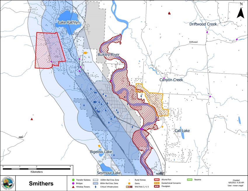
CHAPTER 2: ELECTORAL AREA ‘A’ HAZARD IDENTIFICATION.............................. 3

Electoral Area ‘A’ Geographic Setting......................................................................... 3
Selecting Hazards for Electoral Area ‘A’ ..................................................................... 4
     Unique Local Hazards .......................................................................................... 5
Electoral Area ‘A’ Hazard History ................................................................................ 6
Defining Hazard Considerations for Electoral Area ‘A’.............................................. 8
     Indigenous Traditional Knowledge ..................................................................... 8
     Summary of Climate Patterns .............................................................................. 9
     Flooding: Lakes, Rivers, and Stream ................................................................ 10
     Drought ................................................................................................................ 11
     Landslide/Debris Flow ........................................................................................ 12
     Snowstorms and Blizzards ................................................................................ 13
     Extreme Heat ....................................................................................................... 14
     Lightning ............................................................................................................. 14
     Air Quality............................................................................................................ 15
     Wildfire ............................................................................................................ 17
     Structural Fire ..................................................................................................... 18
     Rail Incident ........................................................................................................ 19
     Aircraft Incident .................................................................................................. 20
     Motor Vehicle Incident........................................................................................ 21
     Plant Disease and Pest Infestation.................................................................... 21
     Human Disease (Including Pandemic and Epidemic) ...................................... 22
     Public Health Crisis ............................................................................................ 23
     Electrical Outage ................................................................................................ 24
     Food Source Interruption ................................................................................... 25
     Earthquake .......................................................................................................... 26
     Dam and Spillways Failure ............................................................................. 26
APPENDIX 1 – ELECTORAL AREA ‘A’ HISTORIC HAZARD EVENTS ..................... 27
APPENDIX 2 – ELECTORAL AREA ‘A’ HYDROMETRIC DATA ............................... 40
APPENDIX 3 – ELECTORAL AREA ‘A’ KNOWN HAZARDS MAP ........................... 42
WORKS CITED ............................................................................................................. 44

                                “Know the Risks, Make a Plan, Be Prepared”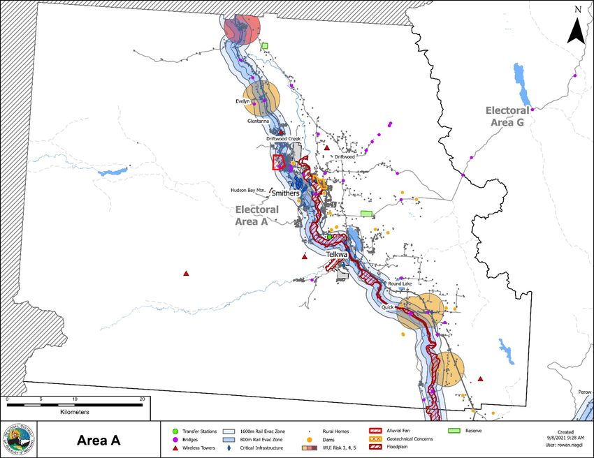
RDBN Hazard, Risk and Vulnerability Analysis Backgrounder
Electoral Area ‘A’ Hazard Identification
Page: 3

CHAPTER 2: ELECTORAL AREA ‘A’ HAZARD
IDENTIFICATION
Electoral Area ‘A’ Geographic Setting
Electoral Area ‘A’ (Smithers/ Telkwa Rural) is the rural area surrounding the Town of
Smithers and the Village of Telkwa. Although the jurisdictional boundaries do not
include any indigenous settlements, there are two unoccupied Witset First Nation
reserve lands Oschawwinna 31 and Jean Baptiste 28, within the Regional District of
Bulkley-Nechako (Regional District). The unincorporated communities within the area
include Driftwood Creek, Glentanna, Evelyn, Quick, Hudson Bay Mountain Ski
Community, and multiple neighbourhoods. (website) Electoral Area ‘A’ is situated on the
Yintah (land) of the traditional territory of the Wet’swet’en, home to the Gitdumden
(Wolf/Bear) and Laksilyu (Small Frog) Clans people 2.
Tucked between the stunning Hudson Bay Mountain to the west, the Babine
Mountain range to the east and Telkwa Range to the South, Electoral Area
‘A’, Smithers Rural is located in the Bulkley Valley, which is in central
northwest BC. The Trans-Canada Highway (Yellowhead Route 16) runs
through the area, which is approximately halfway between Prince Rupert and
Prince George. The area is known for its
natural beauty, high standard of living and
relatively diverse employment
opportunities. The area is renowned for
its world-class steelhead fishing with
several fishing lodges located on nearby
rivers.
Electoral Area ‘A’ is 3,677 square
kilometres in area and is transected by
the Bulkley River. Development in this
unique area is concentrated around the
municipalities of Smithers and Telkwa,
and along the floor of the Bulkley Valley.

1 First nations Profiles, Indigenous and Northern Affair Canada. Witset Profile reserves listed. Retrieved
on March 2, 2021 from: https://fnp-ppn.aadnc-
aandc.gc.ca/fnp/Main/Search/FNReserves.aspx?BAND_NUMBER=530&lang=eng
2 Office of the Wet’suwet’en website, Clan names retrieved on March 2, 2021 from:

http://www.wetsuweten.com/
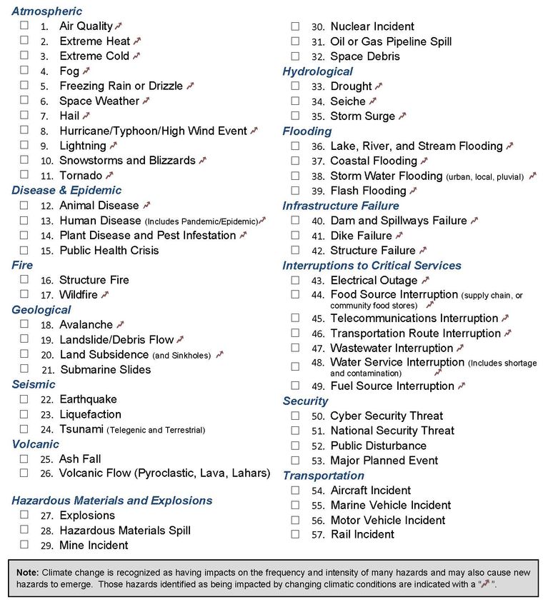
RDBN Hazard, Risk and Vulnerability Analysis Backgrounder
Electoral Area ‘A’ Hazard Identification
Page: 4

Selecting Hazards for Electoral Area ‘A’
The first step in the HRVA process is to identify the possible hazards that will need to be
analyzed in the study area. It will be important that the committee determine the best
approach and decide if there is value in completing a preliminary or high-level review of all
the hazards identified in this section before assessing the frequency, severity, and
consequence of specific hazards.
The list below is an adaptation of hazards identified in the BC Emergency Management
Regulation. Climate change is recognized as having impacts on the frequency and
intensity of many hazards and may also cause new hazards to emerge. This list will guide
the HRVA analysis moving forward. The objective is to identify the mostly likely hazards
and look for historic experience data to be analyzed when scoring the frequency, severity,
and consequence of specific hazards.
RDBN Hazard, Risk and Vulnerability Analysis Backgrounder
Electoral Area ‘A’ Hazard Identification
Page: 5

Unique Local Hazards

Are there additional hazards that are unique to this region that are not covered by the list
above? Please note these hazards below, including any information sources, historical
stories or maps that might help to define these unique local hazards:

HRVA Electoral Area ‘A’ Committee Workbook Backgrounder
Chapter 2: Electoral Area ‘A’ Hazard Identification
Page: 6
Electoral Area ‘A’ Hazard History
Electoral Area ‘A’ has experienced several events that have impacted residents of the
region since the early 1900’s. The regularity of the event happening determines the risk
factor which will be used in the Hazard, Risk, and Vulnerability Analysis.
There are several well-known hazards in Electoral Area ‘A’ including flooding, severe
weather, landslides, hazardous materials and explosions, transportation accidents,
interruptions to critical services, and wildfires. Many of these hazards are high risk and
are a priority to all communities within the Regional District of Bulkley-Nechako.
The graph below shows the actual event types experienced in Electoral Area ‘A’ from
1914 to 2021. The highest recurring event types and severity of impact in this area are:
Flooding;
Ice Jams; and E VE N T T YPES
Severe Weather. E LEC TO RA L A REA 'A '
33
1 9 1 4 TO 2 0 2 1
Appendix 1, Historic Hazard Data, provides the
details on recorded events in Electoral Area ‘A’.
13
The Regional District HRVA 2003 Hazard, Risk,
4
3
2
2
1
1
1
1
and Vulnerability Analysis Priority Matrix
identifies the following hazards:
Very Low Low High Very High
6 Fire – industrial (18) Fire- interface & Frequent or
very likely
Wildfire, Flood (24)
5 Avalanche Dangerous goods spill, Severe Weather
(5) Epidemic- human, (20)
Moderate
Explosion or likely
transportation accident
FREQUENCY
– Road (15)
4 Critical Facility Failure, Transportation accident Earthquake (16)
Occasional,
Infrastructure Failure (8) – Air, Rail (12)
slight
chance
3 Epidemic – Animal (6) Landslide, debris flow Unlikely,
Improbable
(9)
2 Terrorism (6) Highly
unlikely
(rare event)
1 Dam Failure, Mine Volcano Eruption
Very Rare
Accident (2) (4)
event
1 2 3 4
SEVERITY
Risk index # is the Frequency x Severity.
HRVA Electoral Area ‘A’ Committee Workbook Backgrounder
Chapter 2: Electoral Area ‘A’ Hazard Identification
Page: 7

Village of Telkwa Emergency Preparedness Plan 2017 Hazard, Risk, and Vulnerability
Analysis Priority Matrix identifies the following hazards:
                 Very Low             Low                      High                    Very High
             6                                                 Dangerous Goods         Fire- interface &   Frequent or
                                                                                                            very likely
                                                               Spill Flood,            Wildfire (24)
                                                               Transportation
                                                               accident road (18)
             5   Transportation       Infrastructure           Transportation                               Moderate
                                                                                                            or likely
                 accident – Air (5)   Failure (10)             accident – Rail (15)
 FREQUENCY

             4                        Fire – Industrial (8)    Transportation          Earthquake (16)
                                                                                                           Occasional,
                                                               accident – Air, Rail
                                                                                                              slight
                                                               (12)                                          chance
             3                        Earthquake (6)           Severe Weather (9)                            Unlikely,
                                                                                                           Improbable
             2                        Epidemic - Human         Explosion or                                   Highly
                                                                                                             unlikely
                                      (4)                      Emission, Landslide,
                                                                                                           (rare event)
                                                               Debris Flow (6)
             1                        Critical Facility
                                                                                                           Very Rare
                                      Failure (2)
                                                                                                             event
                          1                      2                       3                      4
                                                                       SEVERITY

In addition, the Village of Telkwa Evacuation Guide 2020 identified fourteen hazards and
their likelihood to occur within Telkwa:
                   Type           Emergency,                  Frequency    Magnitude
                                  Disaster, or Incident
                   Natural        Adverse Weather               MED           LOW
                                  Flood (100 yr.)               LOW           LOW
                                  Flood (500 yr.)               LOW           MED

                                  Flood (1,000 yr.)             LOW           HIGH
                                  Ice Jams                      MED           LOW
                                  Landslide                     LOW           MED
                                  Wildland Urban                MED           MED
                                  Interface Fire
                   Human          Accident – Rail               LOW           MED
                   Caused         Accident – Road               HIGH          LOW
                                  HAZMAT – Rail                 LOW           HIGH
                                  HAZMAT - Road                 MED           HIGH
                                  Pandemic                      LOW           HIGH
                                  Power Outage                  MED           MED
                                  Structure Fire                MED           LOW
The Town of Smithers Emergency Response and Recovery Plan 2016 does not contain a
risk matrix.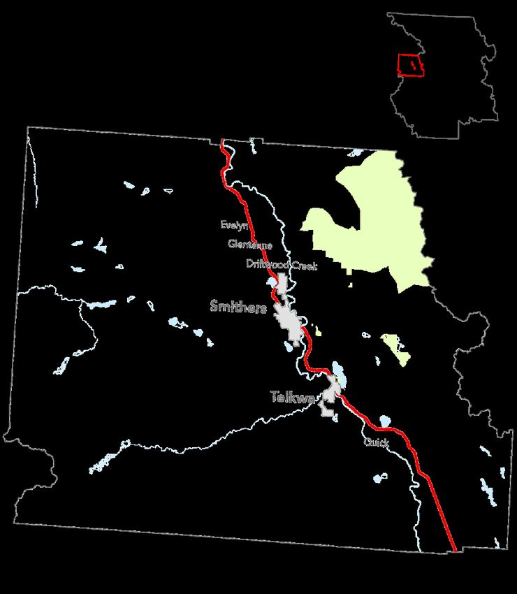
HRVA Electoral Area ‘A’ Committee Workbook Backgrounder
Chapter 2: Electoral Area ‘A’ Hazard Identification
Page: 8

Defining Hazard Considerations for Electoral Area ‘A’
This section provides definitions from the HRVA Hazard Reference Guide 2021 Province
of British Columbia, and the Town of Smithers and the Village of Telkwa emergency
management plans. These definitions and related information can help to inform the
HRVA advisory committee in determining what hazards will be analyzed in this HRVA
process.
The hazards are listed in order based on the highest reoccurring historical event types in
Area A as well as following the Hazard, Risk, and Vulnerability Analysis Priority Matrix’s
from the Regional District HRVA 2003, Village of Telkwa Emergency Preparedness Plan
2017, and Village of Telkwa Evacuation Guide 2020. The top four priority hazards
identified by RDBN staff include:

    Flooding                 Severe Weather               Wildfire     Rail Incidents
Known hazards are also identified on a map of electoral area ‘A’ and can be found in
Appendix 3 of this chapter. HRVA Electoral Area ‘A’ Committee Workbook Backgrounder
Additional hazard definitions and information can be found in the provinces HRVA
Companion Guide 2021.
If you have information on known hazards, resources or details on resiliency strategies
related to the hazards listed below, please include these as notes and pass them on to
the Regional District HRVA Coordinator for inclusion in the analysis.
Indigenous Traditional Knowledge
Long before European explorers and traders arrived in the late 1700s, Indigenous people
in BC told stories and practiced traditions to share important knowledge about natural
hazards. By repeating these stories, Indigenous people passed on valuable information
about how to prepare for and survive disasters across time and across generations.
(Prepare BC Emergency Management BC, 2019)
Those holding traditional knowledge can assist in understanding the nature of local
hazards, suggest appropriate risk reduction and response mechanisms, and even give
options for recovery based on past experiences. They can also help us recognize and
respect the long history and rich traditions of First Nations communities on this land.
(Munsaka, 2018) The Regional District recognizes the importance of learning from
traditional knowledge and is looking to continually strengthen and develop relationships in
the hopes that this knowledge can assist and inform future emergency planning and
preparedness planning.
HRVA Electoral Area ‘A’ Committee Workbook Backgrounder
Chapter 2: Electoral Area ‘A’ Hazard Identification
Page: 9

Summary of Climate Patterns
The information below has been summarized from the Climate Patterns, Trends, and
Projections for the Omineca, Skeena, and Northeast Natural Resource Regions, British
Columbia - Technical Report 097, 2016. (Foord, 2016)
Baseline climate of the Skeena Natural Resource District
 Seasonal/Annual Precipitation              Mean               Maximum             Minimum
                 (mm)                       temperature (°C)   temperature (°C)   temperature (°C)
 Skeena District
 Winter              136.9                          -7.2              8.4              -30.8
 Spring               80.8                           4.4             25.1              -17.5
 Summer              140.6                          13.9             31.4               -0.6
 Fall                165.3                           4.3             24.3              -16.2
 Annual              520.4                           3.9             31.5              -32.4
Skeena District Climate Trends
The Skeena Natural Resource District has become warmer and wetter over the last
century. Mean annual precipitation has increased 5.2%. Most significantly, summer
precipitation has increased by more than 10%. The largest increases in precipitation have
occurred in the Skeena (southern) portion of the Skeena−Stikine District. Mean annual
temperature has increased in the region by 0.2°C. Seasonally, mean winter temperatures
have increased the most throughout the region, by about 0.7°C. The Skeena (southern)
portion of the Skeena−Stikine District has experienced large increases in precipitation
resulting likely in moderate increases in temperature. Summers, overall, are getting
warmer in the region.
Skeena District Climate Projections
Climate projections for the northern regions and districts were made for 2055 (2041–
2070). Mean annual temperature in the Skeena Natural Resource District is projected to
increase by 3.2°C, with minimum temperatures increasing more than maximum
temperatures. Mean annual precipitation for the region is projected to increase by 7%.
Increases will likely be as rainfall because precipitation as snow is projected to decrease
by about 35%. Precipitation is projected to increase the most in the fall. The number of
growing degree-days will increase, and the number of frost-free days will increase. The
greatest increase in the number of frost-free days is projected to occur in the spring.

                                A Note about Climate Change:
     Climate change impacts both the frequency and intensity of many hazards. It
     may also cause new hazards to emerge. In this HRVA methodology, climate
  change is not indicated as a separate hazard; however, those hazards identified as
     being impacted by climate change are indicated with a special symbol. e.g.
                               Drought (BC E. M., 2021)
HRVA Electoral Area ‘A’ Committee Workbook Backgrounder
Chapter 2: Electoral Area ‘A’ Hazard Identification
Page: 10
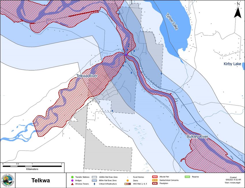
Flooding: Lakes, Rivers, and Stream
Flooding is the overflow of natural drainage channels, natural shorelines and/or
human-made facsimiles leading to partial or complete inundation from the overflow of
inland or tidal waters, and/or the accumulation or runoff of surface waters from any
source. (BC E. M., 2021)
Floods in Electoral Area ‘A’ are caused by natural conditions and geography. The
area experiences a variety of flooding due to:
Heavy Rains or rain-on-snow events in spring, fall, and winter months;
Spring freshet flooding from rapid snow melt;
Intense precipitation at any time of year;
Ice jams in spring, fall, and winter months;
Failure of private dams or flood protection works; and
Debris flows on the fans of steep mountain stream channels.
The Bulkley and Telkwa rivers are of the highest concern in the area.
The Regional District has invested in flood risk assessment in Ebenezer Flats/ Kidd
Road Flood Mitigation Study 2019;
295 addresses are in the floodplain this includes 204 in Telkwa, 10 in Smithers, and
81 in Area ‘A’. of the 81 address in Area ‘A’ 14 are south of Telkwa, 67 are between
Telkwa and Smithers with (47 of which are in the Ebenezer Flats).
The Regional District Floodplain Management Bylaw No. 1878, 2020 was established
to reduce or prevent injury or the loss of life, and to minimize property damage, during
flood events. This bylaw contains drawings for Smithers to Telkwa, Quick to Houston,
and the Quick Area as mapped for 20-year and 200-year frequency events mapped in
1982 and a drawing of Ebenezer Flats from 2018.
The Village of Telkwa has invested in Flood Mitigation Planning.
The Province of BC has invested in Flood Plain mapping along the Bulkley and Telkwa
Rivers. With the BC River Forecast Centre continual monitoring and forecasting river
flows.
See Appendix 2 for hydrometric data reporting annual maximum daily discharge rates
(m3/s) for five Ministry of Environment monitoring stations.
The Village of Telkwa owns and maintains three dikes listed under the Dike
Maintenance Act. The dikes and consequence classification of each are as follows
(ltd., 2019):
o Riverside Street, Dike #300, Minor;
o Bartlett Flood Protection, Dike #302 – Moderate;
o Cottonwood Flood Protection, Dike #303 – Moderate. 3
Witset has identified flood hazard areas in their Witset First Nation Community land
Use Plan.
The Town of Smithers has several owned sites within the 200-year flood plain
including Sewage Treatment Plant, Smithers Airport, Riverside Park, Fairgrounds, and
the Archery Club. Of particular concern, the location of the Town of Smithers sewage
treatment facility.
The Village of Telkwa has several owned sites within the 200-year flood plain including
Riverside Park, Telkwa Municipal Hall, and the Well and Pump Station.
3Dike consequence summary by region can be accessed:
https://www2.gov.bc.ca/gov/content/environment/air-land-water/water/drought-flooding-dikes-
dams/integrated-flood-hazard-management/dike-management#dike_conseqHRVA Electoral Area ‘A’ Committee Workbook Backgrounder
Chapter 2: Electoral Area ‘A’ Hazard Identification
Page: 11
Notable floods in Electoral Area ‘A’ include:
1966 Spring Ice Jam blocked the Bulkley River near Telkwa taking out the Bulkley
River bridge on Highway 16, east of Smithers.
Additional flood accounts can be found in Appendix 1.
Drought
Drought is a recurrent feature of climate involving a deficiency of precipitation
over an extended period, resulting in a water shortage for activities,
communities, or aquatic ecosystems. In BC, combinations of insufficient snow
accumulation, hot and dry weather, or a delay in rainfall may cause drought. (BC
E. M., 2021)
Drought can lead to reduced water availability for household and business use. Lower
stream flows may cause warmer river temperatures, affecting fish and other aquatic
life. Low stream flows can also affect the growth of agricultural crops and limit the
water available for irrigation. Low flows and extended periods of low precipitation can
also have impacts on groundwater levels. Aquifers – particularly those at shallow
depths - may develop a lower water table due to drought in any given year and from
previous drought seasons, as there may not be enough water to recharge the aquifer.
If natural water sources or adequate storage are not available in a community, it may
also lead to insufficient supplies for firefighting. (Econics, May 2021)
Notable regional incidents involving drought:
Due to relatively normal to high snowpacks in the spring, early forecasts did not flag a
drought risk for 2018. However, a heat wave in late spring rapidly depleted snowpacks
and caused freshet flooding earlier than normal. That, and the lack of precipitation
from July to November, created extensive dry conditions across lots of the province.
In 2018, the Northwest, Upper Fraser West, Upper Fraser East, and Nechako regions
reached Level 2 to Level 3 drought ratings, meaning these areas were very dry. (BC
Agriculture & Food Climate Action Initiative, 2019) With the Skeena – Nass (including
Witset, Smithers and Telkwa) reaching level 4 from August 23 to November 8th, being
extremely dry. (Columbia P. o., British Columbia Drought Information Portal, 2021)HRVA Electoral Area ‘A’ Committee Workbook Backgrounder
Chapter 2: Electoral Area ‘A’ Hazard Identification
Page: 12
Landslide/Debris Flow
Debris avalanches and debris flows.
Debris avalanches are extremely rapid debris flows of mud, rock, brush,
trees, and other debris propelled by torrential rains.
Debris flows are a form of rapid mass down-slope movement of a slurry of
loose soils, rocks, and organic matter. (BC E. M., 2021)
The Regional District has invested in geotechnical assessments in the following areas
of Electoral Area A:
Alluvial Fan Study (Lake Kathlyn Area, Smithers) 1991
Geotechnical Assessment Potential Terrain Hazards (Slope Stability) Lower
Viewmount Road Area2006
72 rural area resident addresses are in the Lake Kathlyn Alluvial Fan Area.
49 rural area resident addresses are in aGeotechnical slope concern area on
Viewmount rd.
The Town of Smithers has identified steep slopes as an Environmental Development
Permit Area in the OCP and Schedule B Map.
The Village of Telkwa has identified steep slopes as an Development Permit Area in
the OCP and sensitive ecosystems Map 3.
Witset has identified steep slope areas in their Witset First Nation Community land
Use Plan.
There are a few geotechnical hazards affecting Ministry of Transportation Roads in the
area that include:
Hankin Hill – Highway 16 just east of Telkwa – An ongoing instability, monitored
by Geotech’s. This would affect at least one lane of Highway 16 and requires
engineered design/repair. Detours available along Tyhee Lake Road.
Snake Road – Two instabilities presented themselves on Snake Road this
spring. Though relatively small, repairs/realignment are required. Design is
underway. These instabilities may isolate residents, though there are detours.
Tatlow Road – An ongoing instability, monitored by Geotech’s. This would
affect at least one lane of traffic and requires a realignment of the roadway. No
detours available. 4
Notable landslides/debris flow in Electoral Area ‘A’ include:
May 6, 2017 resident first observed landslide in the Lake Kathlyn Area.
4 Information provided by the Roads Area manager in Smithers (SA25) on October 4th, 2021 by email.HRVA Electoral Area ‘A’ Committee Workbook Backgrounder
Chapter 2: Electoral Area ‘A’ Hazard Identification
Page: 13
Snowstorms and Blizzards
Meteorological disturbance giving rise to a heavy fall of snow, often
accompanied by strong winds. Snowstorm and blizzards impact upon
transportation, powerlines and communications infrastructure, and
agriculture. (BC E. M., 2021)
According to Environment Climate Norm’s 1981-2010 5
Canada, in the Smithers area,
the minimum extreme Annual Rainfall 367.2 mm
temperature recorded was -43.9 Annual Snowfall 182.7 mm
degrees Celsius and occurred in Average Temperature, January -7.2 C
January of 1950. On average, Average Temperature, July 15.2 C
there are less than 1.1 days in Frost-free Days 108 days
January where the temperature Hours of Sunshine 1621 hrs. per year
reaches below -30 degrees Maximum Temperature 37.1 C (June 27, 2021)
Celsius. (Canada E. , 1981- Minimum Temperature -43.9 C (Jan. 13, 1950)
2010)
Snowfall is a common occurrence in the winter months for the Bulkley Valley, although
it is rarely heavy enough to pose a significant risk. Historic climate data collected by
Environment Canada suggests that the prevailing winter winds blow from the
Southeast. During the winter months, the most common winds are south easterlies. It
is important to note that winter winds are generally much stronger than summer winds
in the area. (Canada E. , 1981-2010)
Notable Snowstorms in Electoral Area ‘A’ include:
According to historic climate data, the greatest one-day snowfall of 105.5 centimeters
was recorded on January 16, 1947.
Additional snowstorm accounts can be found in Appendix 1.
5 (Canada E. , 1981-2010)HRVA Electoral Area ‘A’ Committee Workbook Backgrounder
Chapter 2: Electoral Area ‘A’ Hazard Identification
Page: 14
Extreme Heat
Heat waves can be characterized by temperatures significantly above the
mean for an extended period, or by a combination of high temperatures with
high humidity and a lack of air motion. Heat waves impact upon the very
young, the elderly and those with cardiovascular conditions. Heat waves also
impact upon agriculture. (BC E. M., 2021)
Notable Heatwaves in the Electoral Area ‘A’ include:
The last week in June 2021 brought about unprecedent heat in British Columbia and
across western Canada. With forecasts stating it was the warmest stretch since
records have been kept (In many instances 100+ years) ((MSC), 2021). With CBC
reporting 486 sudden deaths over a five-day period from June 25th – 30th, 2021 195%
increase over the approximately 165 deaths that would normally occur in the province
over a five-day period. (Service B. C., 2021)
Temperatures reaching 37.1 ‘C on June 27, 2021. (NAVCAN, 2021)
Lightning
Generally, all the various forms of visible electrical discharge that are produced
by thunderstorms; often seen as a bright flash of light in the sky. Lightning
impacts air transportation, powerlines and communications infrastructure and
causes forest fires. (BC E. M., 2021)
Lightning occurs virtually year-round in the Pacific coastal region. The average date of
the beginning of lightning season in Western Canada (1999-2018) for British Columbia
- Interior – North and high mountain ranges is June 1st. The Average date of the end
of the lightning season in Western Canada (1999-2018) is between October 1st and
November 1st. (Canada G. o., Lightning Statistics, 2016)
The Canadian Lightning Detection Network (CLDN) was established in 1998 and
consists of over 80 lightning sensors distributed across Canada. (Canada G. o.,
Lightning, 2016)
Some quick facts regarding forest fires from Natural Resources Canada, Forest fires
started by lightning, represent 45 per cent of all fires and 81 per cent of the total area
burned in Canada, and occur in remote locations and often in multiple
clusters. (Canada G. o., Lightning Statistics, 2016)
Notable lightening data in Electoral Area ‘A’ includes:
Total ground to cloud lighting strikes from 1999-2018 in Smithers was 1858 and the
average number of lightening days (within 25km) is 9.5. (Canada G. o., Lightning
Statistics, 2016)HRVA Electoral Area ‘A’ Committee Workbook Backgrounder
Chapter 2: Electoral Area ‘A’ Hazard Identification
Page: 15
Air Quality
Solids, liquids, or gases which, if discharged into the air, may result in statutory
air pollution. (BC E. M., 2021)
Communities in this region experience air quality episodes due to elevated particulate
concentrations at various times throughout the year. Particulate matter is a concern for
human health and from an aesthetic point of view. Smithers has an air quality
monitoring station that provides an Air Quality Health Index (AQHI), hourly air quality
readings, and related health messages. The AQHI reports on the health risks posed by
a mixture of pollutants, including particulate matter (PM2.56), ground-level ozone (O3),
and nitrogen dioxide (NO2). (BC A. Q., 2021) These readings illustrate the level of
health risks with a number and advice on minimizing health risks from air pollutants.
The most significant air pollutant in the Bulkley Valley Lakes District (BVLD) is fine
particulate matter, PM2.5, from open burning, industrial sources, wood burning
appliances, backyard burning, transportation road dust and vehicle emissions. A
study conducted by Elliot and Copes (2011) has estimated that between 16 to 74
deaths each year are attributable to fine particulate matter concentrations in Northern
and Interior Health Regions alone. (Zirnhelt, June 21, 2021)
In Canada, wildfires can significantly increase air pollution levels of fine particulate
matter (PM2.5) posing the greatest human health risk (Canada H. , 2021).
Elevated PM2.5 typically occur in the autumn and winter months when dispersion is
poor and many different emission sources (industry, space heating, open burning) are
active. (Zirnhelt, June 21, 2021)
Notable Air quality data in Electoral Area ‘A’ includes:
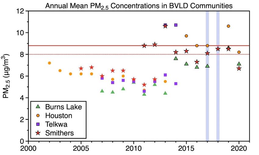
The Province of BC has one active Air Quality Monitoring station located in this region
Smithers Muhiem Memorial. (Columbia P. o., 2021)There was an average level of 8.3
PM2.5 over the last ten years
(data missing for 2019) with
the highest average year in
2013 with an average level of
10.1 PM2.5. 7-10 PM2.5 is a
High Health Risk according
to the AQHI.
Since 2011 Smithers air
quality, annual mean PM2.5
concentrations, has
exceeded the provincial air
quality objectives (8 or 25
ug/m3) consistently, with
2016 and 2020 being slightly
below the provincial
objectives.
6 PM2.5 Particulate matter with a diameter of less than 2.5 micrometers (µm). One micrometer is one
millionth of a metre. PM2.5 is included in fine particulate and is a subset of PM10 (when measuring PM10, it
includes PM2.5). PM2.5 is typically associated with combustion sources (smoke) and is more closely related
to adverse health effects than larger particles.HRVA Electoral Area ‘A’ Committee Workbook Backgrounder
Chapter 2: Electoral Area ‘A’ Hazard Identification
Page: 16
A day is considered an advisory level day if the daily (24-hour) concentration is greater
than the provincial objective of 25 ug/m3 for PM2.5. The following chart provides the
number of air quality advisory days in Smithers issued by the Ministry of Environment
since 2013 7:
Year # of days under advisory for fine PM2.5
2013 11
2016 15
2017 19
2018 4
2019 2
2020 1
There are three Purple Air Quality Monitoring stations in Telkwa, six in Smithers, one
in the RDBN north of Lake Kathlyn and one in Witset.
7Data received from Ben Weinstein Sr Air Quality Meteorologist Monitoring, Assessment and Stewardship
Environmental Protection on August 12, 2021HRVA Electoral Area ‘A’ Committee Workbook Backgrounder
Chapter 2: Electoral Area ‘A’ Hazard Identification
Page: 17
Wildfire
An unplanned fire - including unauthorized human-caused fires - occurring on
forest or range lands, burning forest vegetation, grass, brush, scrub, peat lands, or
a prescribed fire set under regulation which spreads beyond the area authorized
for burning.
The wildland urban interface (WUI) is any area where combustible forest fuel is found
adjacent to homes, farm structures or other outbuildings. This may occur at the
interface, where development and forest fuel (vegetation) meet at a well-defined
boundary, or in the intermix, where development and forest fuel intermingle with no
clearly defined boundary. (Service, 2021)
2 rural area addresses are in a high Wildfire Urban Interface risk area. There are
substantially more in the medium risk areas in Area A.
The Village of Telkwa has a Community Wildfire Protection Plan developed in 2008.
The plan is out of date however identifies two common hazards. The first being the
Canadian National (CN) rail line that passes thru the Village of Telkwa and falls into
moderate threat management units in the Telkwa Fire Protection area. The second
common hazard being the large power lines that are a likely ignition source within the
Telkwa FPA especially if dead trees are bordering them.
Fire is a natural, normal process in many ecosystems and is necessary to maintain a
healthy forest and a diversity of plant and animal life. In the Bulkley Fire Zone, about
53% of wildfires occur naturally (from lightning strikes). (Patrick Ferguson, 2021)
Town of Smithers Community Wildfire Protection Plan 2012 (ConsultantsLtd., 2012)
identifies common ignitions sources as follows: grass fires in April/May, industrial
burning escapes (fires set with purpose), lightning, and misc. escaped campfires,
smokers, other miscellaneous ignition.
The Town of Smithers is surrounded by forests classified as Engelmann Spruce—
Subalpine Fir and is considered as a medium fire hazard zone. The Town of Smithers
has several wildland-urban interface fire areas that annually experience long periods of
moderate to high fire danger during the summer and early fall. (Smithers, 2016)
Notable fires outside Electoral Area ‘A’
In the summer of 2018, the RDBN mobilized its emergency management structure for
over 72 days in response to 15 major fires which resulted in 64 evacuation orders and
alerts with 1,544 dwellings under evacuation order, affecting approximately 3,475 people
and requiring the relocation of over 3,000 livestock. Eight dwellings and over 45 other
structures were lost and a declaration of state of local emergency was in place from
August 1 to September 20. (Inc., 2019)HRVA Electoral Area ‘A’ Committee Workbook Backgrounder
Chapter 2: Electoral Area ‘A’ Hazard Identification
Page: 18
Structural Fire
Urban fires are fires that occur in a residential, commercial, or industrial community.
Rural and urban fires occur on a frequent basis in many parts of the province, and of
provincial concern are the fires that cause many deaths and injuries, those that are
beyond the ability of the local resources to respond or those that cause severe
economic losses. For interface fires, see wildfires. (BC E. M., 2021)
In 1914 the Smithers Fire Brigade asked the Hazelton Fire Brigade to assist in
organizing a fire department in Smithers. (News I. , 2014)
Notable Structural Fires in the Electoral Area ‘A’ include:
May 9, 2019, Smithers recycling depot burn. Smithers, Telkwa and Houston
firefighters were on scene and no injuries were reported. (Barker, 2019)
April 30, 1993, a major industrial fire at PIR sawmill, division of West Fraser Mills.
1000 truck loads of logs were lost, 150 people, including Telkwa and Moricetown Fire
Departments were involved, and it raged for 2 days, started from a beehive burner
spark. (News I. , 2014)
August 2013 Hometown Furniture and Perry & Co. burnt next to the newly owned
Bovill Square DURING Smithers Centennial Celebrations. (News I. , 2014)
Feb 1965 Standard Oil (Chevron) bulk storage facility on Railway Ave. Three 20,000
gal. gas and oil storage tanks were near the fire. No explosion, and no loss of life
during the prevention of this fire. (News I. , 2014)
Two Bridges restaurant in Telkwa burnt down, in approximately 2010. This building
was located adjacent to the Telkwa Pub and required the call for mutual aid from the
Smithers Fire department. This fire drained the Village’s water reservoir and resulted
in a boil water advisory for the entire Village.
Smithers Recycling centre burnt down in 2020 causing large plumes of smoke and
required mutual aid from Telkwa fire department
October 2019 a townhouse on Main Street in Smithers burnt displacing 5 families.HRVA Electoral Area ‘A’ Committee Workbook Backgrounder
Chapter 2: Electoral Area ‘A’ Hazard Identification
Page: 19
Rail Incident
An incident involving a passenger, cargo or light-rail train that results in
damage, bodily injury, or death. (BC E. M., 2021)
The CN Rail northern main line crosses the area from east to west roughly paralleling
the Highway # 16 corridor traveling through the communities of Telkwa and Smithers.
Along this part of its route, it mainly travels on the west side of the Bulkley River. A
major rail accident in the area could seriously impact residents, the environment, and
cut off large areas to emergency services, particularly if hazardous materials were
involved.
To have rail service interrupted for any length of time would seriously impact the
transport of goods to and from the area.
Rail traffic will increase substantially over the next few years as the Prince Rupert
container port construction continues and this will further increase the risk of, and the
effects of a CN Rail transportation route failure.
There are volumes of hazardous materials transported by CN rail along this route to
Prince Rupert including:
Substance PIN # 8 and Recommended Evacuation Radius 9
LP Gas UN1978 Initial downwind evacuation for at least 800m
Gasoline UN1203 Initial evacuation for 800 meters in all directions
MTBE (Methyl-tert-butylether) UN2398 Initial evacuation for 800 meters in all directions
Methanol UN1230 Initial evacuation for 800 meters in all directions
Fuel Oil Diesel Fuel UN1202 Initial evacuation for 800 meters in all directions
Caustic Soda UN1823 Initial evacuation for 800 meters in all directions
Sulphuric Acid UN1830 Initial evacuation for 800 meters in all directions
Anhydrous Ammonia UN1005 Initial evacuation for 1600 meters in all directions
Hydrogen Peroxide UN2014 Initial evacuation for 800 meters in all directions
Chlorine UN1017 Initial evacuation for 800 meters in all directions
Sulphur Dioxide UN1079 Initial evacuation for 1600 meters in all directions
In March of 2020, a CN train derailed east of Prince George BC, forcing a school
evacuation. This derailment included seven cars carrying liquefied petroleum gas
(LPG), an extremely flammable product. Twenty-eight cars went off the tracks.
(Trumpener, 2020)
Notable Rail Incidents in Electoral Area A:
On January 4th, 2012, in Smithers, there was a collision with motor vehicle at a public
crossing. 2 adults and 1 child escaped vehicle before impact. (Haggerstone, 2013)
On February 21st, 2012, approximetly12 km east of Smithers in Telkwa, 46 coal cars
derailed, spilling coal and damaging cars and rails. (Haggerstone, 2013)
On August 4th, 2012, on the Telkwa Mine Road near Telkwa B.C., there was a collision
with a motor vehicle at a public crossing, no injuries reported. (Haggerstone, 2013)On
October 2018 five train cars carrying wood pellets derailed while being moved into a
rail yard in Smithers. The cause was unknown (Grace-Dacosta, 2018)
8 PIN means product identification number as designated by Transportation Canada for the transportation of dangerous goods.
9 Distances for evacuation zones can be references in the North American 2016 Emergency Response Guidebook available at
https://www.phmsa.dot.gov/sites/phmsa.dot.gov/files/docs/ERG2016.pdfHRVA Electoral Area ‘A’ Committee Workbook Backgrounder
Chapter 2: Electoral Area ‘A’ Hazard Identification
Page: 20
Aircraft Incident
An incident involving one or more aircraft that results in damage, bodily injury,
or death. (BC E. M., 2021)
The Smithers Airport is the only airport within the Regional District of Bulkley-Nechako
with scheduled air service. Air carriers include Air Canada, Northern Thunderbird Air,
and Central Mountain Air.
The Smithers Regional Airport is mandated in accordance with Transport Canada
Aerodrome Standards & Recommended Practices TP312E maintain and update an
Emergency Response Plan for the airport grounds, operations, and air space under their
jurisdiction.
10The Smithers Regional Airport has reported the following breakdown of aircraft
movement and passenger counts over the last four years:
SMITHERS AIRPORT PASSENGER AND AIRCRAFT
MOVEMENT STATISTICS
45,000 Year to Date
40,000
35,000
30,000
25,000
20,000
15,000
10,000
5,000
0
# of # of
Total # of Aircraft
Scheduled Chartered
Passengers Movements
Passengers Passengers
2018 Totals 35,004 4,360 39,364 5,780
2019 Totals 36,769 5,000 41,769 4,889
2020 Totals 13,912 5,164 19,076 3,985
2021 Totals 7,508 5,939 13,447 5,111
In addition to the risk of aircraft damage and injury to passengers, an aircraft crash may
have other effects on residents. A wildfire may be started by an aircraft crash, causing
damage to property and resources, and possible evacuation of residents.
Airports can also be a supporting asset to regional emergencies as there is the capacity
to move people, goods and services in and out of the region.
10 Provided by Rob Blackburn Smithers Regional Airport ManagerHRVA Electoral Area ‘A’ Committee Workbook Backgrounder
Chapter 2: Electoral Area ‘A’ Hazard Identification
Page: 21
Motor Vehicle Incident
An incident involving a truck, car, bus, farm vehicle, or any other motor- or
person-powered vehicle that results in damage, bodily injury, or death. (BC E. M.,
2021)
Highway 16 runs through the region, transecting both Smithers and Telkwa. This route
contributes to the risk of motor vehicle crashes in the area, with the majority being
reported along Highway 16. The chance of a hazardous materials spill is also high due
to the growing volume of truck traffic.
According to the Insurance Corporation of British Columbia North Central Crashes 2016
to 2020, there were 204 reported casualty crashes11 in Smithers, and 38 reported
casualty crashes in Telkwa. (ICBC, 2020)
Plant Disease and Pest Infestation
Plant diseases include invasive pests including insects and mites, and plant
pathogens including fungi, bacteria and viruses’ impact upon crops, forests,
and urban environments. New introductions and/or widespread outbreaks
could have severe economic and environmental consequences. (BC E. M., 2021)
With climate change, shifts in the distribution, lifecycles, and prevalence of agricultural
pests (insects, diseases, weeds, and invasive species) are anticipated. Increasing
average annual temperatures (in particular winter minimum temperatures) combined
with shifting precipitation patterns are already magnifying pest impacts, pest
management complexity and associated costs of production.
The region has been significantly impacted by Mountain Pine Beetle outbreaks, in part
due to increased winter survival rates. Modelling of changes to bio geoclimatic zones
(BGC zones) how that the Interior Douglas Fir zone will spread northward and
increase in area, while the Sub-Boreal Spruce zone will decrease dramatically. While
this modeling was completed with a forestry lens, agricultural pests associated with
these ecosystems would be expected to shift along with the BGC zones. (BC
Agriculture & Food Climate Action Initiative, 2019)
11 “Casualty Crash” (ICBC collision data) motor vehicle crashes resulting in an injury or fatality.HRVA Electoral Area ‘A’ Committee Workbook Backgrounder
Chapter 2: Electoral Area ‘A’ Hazard Identification
Page: 22
Human Disease (Including Pandemic and Epidemic)
Diseases that are caused by pathogenic microorganisms and are spread
directly, or indirectly, from one person to another. Diseases can impact public
health, cause death, have economic implications, and result in mass casualty
response. These include epidemics such as meningitis, pandemic flu, hepatitis,
E. coli, and other communicable diseases.
A pandemic is the worldwide spread of a new disease. The total number of
people who get severely ill can vary. However, the impact or severity tends to
be higher in pandemics in part because of the much larger number of people in
the population who lack pre-existing immunity to the new virus. (BC E. M., 2021)
Notable Pandemic Incidents in BC:
COVID-19 Pandemic (2020)
Ebola (2013-16
H1N1 Flu Pandemic (2009)
SARS Outbreak (2003)
The lands in BC have been populated by the ancestors of First Nations since time
immemorial. Epidemics spread through First Nations communities in advance of
explorers. Some researchers have suggested epidemics reached the Northwest Coast
as early as the 1500s, believing the well-known epidemics from the Caribbean and
Central America may have spread to the Pacific Coast through native trade networks
and social contact. Some of the recorded epidemics in the Interior were known to have
originated on the prairies during the historic period (early 1800s). The introduction of
infectious diseases from Europe and Asia into the Northwest Coast and adjacent
areas, and an increase in the severity of warfare, had devastating effects on the
people. Smallpox, influenza, measles, and whooping cough were recorded epidemics,
with smallpox particularly recurring with devastating effects in the native population.
The 1918-19 influenza pandemic was the last major epidemic to seriously affect First
Nations and marked the end of the epidemic cycles that had begun over 150 years
previously. In some cases, entire villages were significantly reduced in single disease
events, with mortality rates ranging from 50% to 90% of the population. (First Nations
Health Council, 2011)
History of Pandemics: https://www.visualcapitalist.com/history-of-pandemics-
deadliest/HRVA Electoral Area ‘A’ Committee Workbook Backgrounder
Chapter 2: Electoral Area ‘A’ Hazard Identification
Page: 23
Public Health Crisis
A localized or regional event that poses or causes a significant threat to the
health of human populations. The event may be declared as a Public Health
Emergency if the event meets at least two of the following criteria:
a regional event that could have a serious impact on public health;
a regional event that is unusual or unexpected;
there is a significant risk of the spread of an infectious agent or a
hazardous agent; and
there is a significant risk of travel or trade restrictions because of the
regional event.
An example of a Public Health Crisis is the contamination of a communities
drinking-water supply by a hazardous material. If the event is regional in nature
and poses a serious impact to public health, it may be declared a Public Health
Emergency. (BC E. M., 2021)
Overdose B.C.`s Public Health Emergency Progress Update on B.C.`s Response to
the Overdose Crisis reported that on April 14, 2016, B.C.’s provincial health officer
declared a public health emergency under the Public Health Act. In July 2017, the
Ministry of Mental Health and Addictions was established, in part, to work in
partnership to develop an immediate response to the overdose emergency. (Columbia
B. , 2021)
Preliminary data in 2021 has found that fentanyl or its analogues have been detected
in 85% of all illicit drug toxicity deaths. In 2020, fentanyl or its analogues have been
detected in 86% of deaths. (Service C. , 2021) In the Northwest 12 the Illicit drug toxicity
deaths between 2011-2021 have increased and are reported as follows:
2011 2012 2013 2014 2015 2016 2017 2018 2019 2020 2021 13
1 0 6 2 6 10 8 14 16 17 16
By Health Authority (HA), in 2021, the highest rates were in Vancouver Coastal Health
(46 deaths per 100,000 individuals) and Northern Health (45 per 100,000). Overall, the
rate in BC is 39 deaths per 100,000 individuals in 2021.
The 2019 Taking the Pulse of the Population An Update on the Health of British
Columbian identifies positive Mental Health as a public health challenge and a
provincial goal. Collecting public health statistics as indicators to monitor this complex
public health crisis. Under Section 66 of the Public Health Act, the Provincial Health
Officer (PHO) has the authority and responsibility to monitor the health of the
population in BC, and to provide independent advice on public health issues and the
need for legislation, policies, and practices respecting those issues.
Read: https://www2.gov.bc.ca/assets/gov/health/about-bc-s-health-care-system/office-
of-the-provincial-health-officer/overdose-response-progress-update-aug-dec-2020.pdf
12Smithers and Houston are in the Northwest Health Service Delivery Area.
13https://www2.gov.bc.ca/assets/gov/birth-adoption-death-marriage-and-divorce/deaths/coroners-
service/statistical/illicit-drug.pdfHRVA Electoral Area ‘A’ Committee Workbook Backgrounder
Chapter 2: Electoral Area ‘A’ Hazard Identification
Page: 24
Electrical Outage
A deficit, interruption or failure of electricity or power systems, services,
supplies, or resources. Power outages occur on a regular basis, however, they
become a concern when the power outage is for a significant amount of time,
when the temperatures are very low, or critical infrastructure, persons, livestock,
or businesses are affected. (BC E. M., 2021)
Power outages occur on a regular basis, however, they become a concern when the
power outage is for a significant amount of time, when the temperatures are very low,
or critical infrastructure, persons, livestock, or businesses are affected.
Historical electrical outage events in Area ‘A’ are documented in association with
other hazards accounts and can be found in Appendix 1.HRVA Electoral Area ‘A’ Committee Workbook Backgrounder
Chapter 2: Electoral Area ‘A’ Hazard Identification
Page: 25
Food Source Interruption
Food shortages occur when the population of a community undergoes a severe
shortage of food. A severe shortage of food can lead to starvation, illness and,
in extreme cases, death. (BC E. M., 2021)
Statistics Canada provides data on the primary types of locations where BC residents
buy their food. If residents in the region are representative of BC, they would be
expected to buy 87% of their grocery shopping from supermarkets and other grocery
stores. The remaining 13% is purchased from convenience and speciality stores.
(Strategies, March 2021) Much of the food in the stores is shipped in through the
major highway transportation corridors that are susceptible to external hazards and
emergencies that can lead to food source interruptions in this region.
Agriculture in the Bulkley-Nechako is predominantly ranching and forage
country. Most agricultural activity is in the west (Bulkley Valley) and east of the region
(Nechako Valley) where land, business, and organizations support diverse agriculture
activities (Strategies, March 2021). The Bulkley valley supports one abattoir facility, a
well-established farmers’ market, and strong local support of the agriculture sector
through grocers and restaurants.
The cost of locally grown and produced food remains high within the region.
The average family in the Northern Health region Valley spends $1038 a month on
groceries (BC Centre for Disease Control Provincial Health Services Authority, 2018).
Canada’s Food Price Report 2021, which forecasts an overall food price increase of
between 3% and 5% this year. (PREPARED BY DALHOUSIE UNIVERSITY |
UNIVERSITY OF GUELPH | UNIVERSITY OF SASKATCHEWAN | UNIVERSITY OF
BRITISH COLUMBIA, 2021)
Notable Incidents involving food source interruptions:
COVID-19 Pandemic (Started 2020) exasperated food insecurity for Canadian who
already had food security and affordability issues. Locally, the 2020 COVID-19
Pandemic prompted transportation delays and crisis in availability of food at the
grocery stores following the March 2020 provincial lockdowns. The grocery stores
implemented purchase limits and store shelves were empty. “Food bank numbers in
the local area increased by 22% at the start of COVID-19 and again increased now
that government COVID subsidies have stopped.” (Salvation Army Food Bank
Coordinator, 2021)
Big Bar Landslide, BC (2019) caused a decline in salmon fisheries affecting FN food
supplies.
The 2016 ice storms in the Lower Mainland prompted an inevitable crisis — highways
were closed, and food trucks couldn’t make it up here. Store shelves started emptying.
This was compounded by the fact that the grocery store in neighbouring Houston had
been closed for a few months and so everyone was shopping in Smithers. We were
having a food system breakdown.HRVA Electoral Area ‘A’ Committee Workbook Backgrounder
Chapter 2: Electoral Area ‘A’ Hazard Identification
Page: 26
Earthquake
An earthquake is defined as the shaking of the ground due to movement along
a fault rupture. When a large magnitude earthquake occurs, energy traveling in
seismic waves may cause damage to structures, trigger landslides, liquefaction,
or other geologic hazards and, in certain circumstances, generate tsunamis.
Impacts from earthquakes can be widespread and severe. (BC E. M., 2021)
The Regional District’s risk for seismic activity is considered medium to low (Canada
G. S., 2015).
Regional District residents would experience minimal physical impact; however, there
could be a significant event that could impact the delivery of goods and services,
depending on the location of the epicentre and the impact on major transportation
routes from the east and the south.
The five biggest earthquakes in BC occurred in 1700, 1946, 1949, 1970 and 2012?
They ranged in magnitude from 7.3 (1946) to 9.0 (1700).
Dam and Spillways Failure
A breach in the foundations, abutments, or spillways of a dam, which results in
a sudden, rapid, and uncontrolled release of the impounded water. n
earthquake is defined as the shaking of the ground due to movement along a
fault rupture. (BC E. M., 2021)
The Dam Safety Regulation under the Water Sustainability Act, objective is to mitigate
loss of life and damage to property and the environment from a dam breach by
requiring dam owners to inspect their own dams, undertake proper maintenance on
them, and ensure that these dams meet ongoing engineering standards. The dam
administered under this regulation are associated with dams that store or divert fresh
water from a stream or aquifer or both. These dams are inspected annually and
assigned a failure consequence and risk rating according to the Dam Safety
Regulations of BC. 14
In Area A there are 19 dams regulated under the Dam Safety Regulations, five of
which have a failure consequence of significant and a failure probability rating being
small. Meaning that the risk level is of no concern and includes regular audit
programs to identify any changes to operation. (Staff, 2009)
If a has a failure consequence of significant or higher than the owner is required to
provide a record containing information for the use of the local emergency authorities
for the dam for the purpose of preparing local emergency plans under the Emergency
Program Act.
Tailing Storage Facilities, including mining dams, in British Columbia are regulated
under Part 10 of the Health, Safety and Reclamation Code for Mines in British
Columbia (the Code), as established under the Mines Act. These facilities require
annual inspections commonly called Dam Safety Inspection that report on risk data.
This data is available to the public on the BC Mine Information website. There are no
mine tailing ponds 15 in Area A.
14 Michael Trudell, Senior Dam Safety Officer.
15 BC Mine information website: https://www.mines.nrs.gov.bc.ca/mapHRVA Electoral Area ‘A’ Committee Workbook Backgrounder
Appendix 1 – Electoral Area ‘A’ Historic Hazard Events
Page: 27
APPENDIX 1 – ELECTORAL AREA ‘A’ HISTORIC
HAZARD EVENTS
Historic Hazard Experience
Event Impact
Year Severity Cause Description
Type Effect
train & Incessant rains, 147mm/4days. Slides east and west
rain on transportation of Smithers. Bulkley River rose significantly, carrying
1914 Flooding moderate
Snow delay - 36 large quantities of trees and driftwood. Train traffic
hours delayed for 36 hours.
Incessant rains, 147mm/4days. Slides east and west
rain on of Smithers. Bulkley River rose significantly, carrying
1914 Landslide moderate train delay
Snow large quantities of trees and driftwood. Train traffic
delayed for 36 hours.
Telkwa Fiver and Bulkley River rose suddenly
Spring washed the Telkwa River bridge out. Cut a new
1916 Flooding high transportation
Run off channel under the government bridge. Traffic was
suspended as a result.
gale Gale force winds, upset buildings, downed trees,
telephone,
1917 Hurricane high force Telephone, and telegraph wires were put out of
telegraph
winds commission.
Gale winds downed trees & ranch buildings. High
waters in Bulkley River caused extensive damage to
Rain on Telkwa River Bridge. Smaller bridges further
1917 Flooding high transportation
Snow upstream were washed out or damaged. Roads
through Telkwa were impassable. Had had unusual
wet summer and fall.
Ice in the Bulkley River jammed at the turn near the
bridge east of Telkwa. The backed-up water flooded
the flats upstream and thin layer of ice were
transportation, deposited. One chunk of ice as big as a house was
1919 Ice Jam high Ice jam
industry in one of the fields until haying season. Ice also took
out two spans of the bridge across the Bulkley River
at Huber. Business section along river was flooded.
Road along river was littered with chunks of ice.
Heavy Heavy rains (close to 30 cm in a 24-hour period)
Rains in turned highway through Smithers into a "sea of mud".
1923 Flooding low transportation
24-hour Main St. was reported "to have started to run east
period and west in places."
In Walcott a small settlement between Telkwa-
Houston, children residing on west side of the
Spring Bulkley River were unable to attend school due to
1931 Flooding low Transportation
Run off flooded conditions of the river. Used to be a ferry at
Walcott but was condemned for public use and was
replaced with the present suspension bridge)
Bulkley River hit an all-time high for fall runoff with
Quick recording the maximum daily discharge of
Rain on 838m3/s Smithers bridge was damaged. Telkwa
1935 Flooding high Transportation
Snow river changed course, bridge at Telkwa washed out.
Dynamite was used to prevent logjams. Business
section of Telkwa and Coal Mine were flooded.You can also read