Hazard Mitigation Plan - Westminster, Massachusetts - Town of Westminster MA
←
→
Page content transcription
If your browser does not render page correctly, please read the page content below
Westminster, Massachusetts
Hazard Mitigation Plan
                    June 2021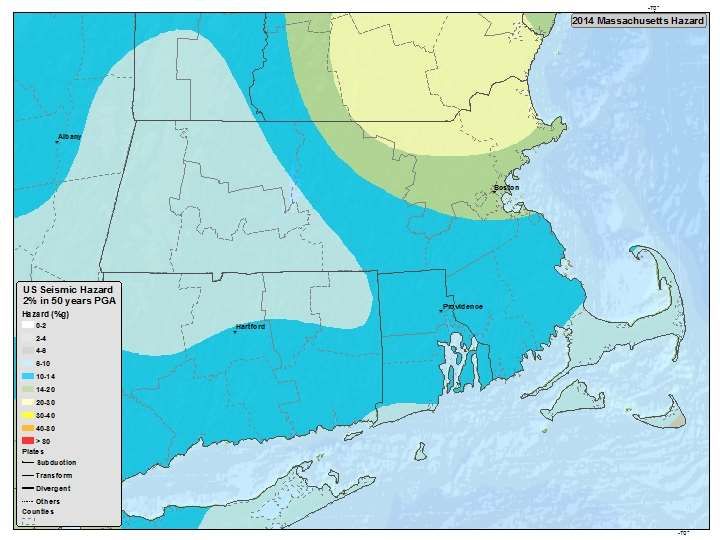
Hazard Mitigation Plan
Westminster, Massachusetts

Prepared by:    BETA GROUP, INC.
Prepared for:   Town of Westminster

June 2021
Hazard Mitigation Plan
Westminster, Massachusetts

  TABLE OF CONTENTS
  1.0 Introduction ............................................................................................................................................ 1
      1.1 Federal Disaster Mitigation Act .......................................................................................................... 1
      1.2 Hazard Mitigation Plan Purpose ......................................................................................................... 1
  2.0 Planning Process ..................................................................................................................................... 1
      2.1 Local Hazard Mitigation Planning Team ............................................................................................. 1
      2.2 Planning Process Summary................................................................................................................. 2
      2.3 Public Participation ............................................................................................................................. 2
  3.0 Municipal Vulnerability Preparedness .................................................................................................... 2
      3.1 Community Resilience Building Workshop......................................................................................... 3
  4.0 Community Profile .................................................................................................................................. 4
      4.1 Geography .......................................................................................................................................... 4
      4.2 Climate ................................................................................................................................................ 4
      4.3 Demographics ..................................................................................................................................... 4
      4.4 Infrastructure ...................................................................................................................................... 4
      4.5 Historic Properties .............................................................................................................................. 5
  5.0 Critical Infrastructure .............................................................................................................................. 5
  6.0 Risk Assessment ...................................................................................................................................... 9
      6.1 Overview of Hazards and Impacts ...................................................................................................... 9
      6.2 Flood Related Hazards ...................................................................................................................... 10
          6.2.1 Hazard Overview ....................................................................................................................... 10
          6.2.2 Significant Hazard Events .......................................................................................................... 10
          6.2.3 Hazard Location......................................................................................................................... 11
          6.2.4 Dam and Dam Failure ................................................................................................................ 11
      6.3 Hurricanes and Tropical Storms ....................................................................................................... 13
          6.3.1 Hazard Overview ....................................................................................................................... 13
          6.3.2 Significant Hazard Events .......................................................................................................... 14
          6.3.3 Hazard Location......................................................................................................................... 15
      6.4 Nor’easter ......................................................................................................................................... 15
          6.4.1 Hazard Overview ....................................................................................................................... 15
          6.4.2 Significant Hazard Events .......................................................................................................... 15
          6.4.3 Hazard Location......................................................................................................................... 17
      6.5 Earthquake........................................................................................................................................ 17
          6.5.1 Hazard Overview ....................................................................................................................... 17

                                                                                                                                                                       i
Hazard Mitigation Plan
Westminster, Massachusetts

         6.5.2 Significant Hazard Events .......................................................................................................... 19
         6.5.3 Hazard Location......................................................................................................................... 20
     6.6 Landslide ........................................................................................................................................... 20
         6.6.1 Hazard Overview ....................................................................................................................... 20
         6.6.2 Significant Hazard Events .......................................................................................................... 21
         6.6.3 Hazard Location......................................................................................................................... 21
     6.7 Snow & Blizzard ................................................................................................................................ 21
         6.7.1 Hazard Overview ....................................................................................................................... 21
         6.7.2 Significant Hazard Events .......................................................................................................... 22
         6.7.3 Hazard Location......................................................................................................................... 22
     6.8 Ice Storms ......................................................................................................................................... 23
         6.8.1 Hazard Overview ....................................................................................................................... 23
         6.8.2 Significant Hazard Events .......................................................................................................... 23
         6.8.3 Hazard Location......................................................................................................................... 23
     6.9 Wildfires............................................................................................................................................ 23
         6.9.1 Hazard Overview ....................................................................................................................... 23
         6.9.2 Significant Hazard Events .......................................................................................................... 24
         6.9.3 Hazard Location......................................................................................................................... 24
     6.10 Thunderstorms ............................................................................................................................... 24
         6.10.1 Hazard Overview ..................................................................................................................... 24
         6.10.2 Significant Hazard Events ........................................................................................................ 25
         6.10.3 Hazard Location....................................................................................................................... 25
     6.11 Tornadoes ....................................................................................................................................... 25
         6.11.1 Hazard Overview ..................................................................................................................... 25
         6.11.2 Significant Hazard Events ........................................................................................................ 27
         6.11.3 Hazard Location....................................................................................................................... 28
     6.12 Drought ........................................................................................................................................... 28
         6.12.1 Hazard Overview ..................................................................................................................... 28
         6.12.2 Significant Hazard Events ........................................................................................................ 29
         6.12.3 Hazard Location....................................................................................................................... 30
     6.13 Extreme Temperature .................................................................................................................... 30
         6.13.1 Hazard Overview ..................................................................................................................... 30
             6.13.1.1 Extreme Heat ................................................................................................................... 30
             6.13.1.2 Extreme Cold .................................................................................................................... 31
         6.13.2 Significant Hazard Events ........................................................................................................ 32
ii
Hazard Mitigation Plan
Westminster, Massachusetts
6.13.2.1 Extreme Heat ................................................................................................................... 32
6.13.2.2 Extreme Cold .................................................................................................................... 32
6.13.3 Hazard Location....................................................................................................................... 32
6.14 Coastal Erosion ............................................................................................................................... 33
6.14.1 Hazard Overview ..................................................................................................................... 33
6.14.2 Significant Hazard Events ........................................................................................................ 33
6.14.3 Hazard Location....................................................................................................................... 33
7.0 Vulnerability Assessment ...................................................................................................................... 33
7.1 Flood Related Hazards ...................................................................................................................... 34
7.1.1 Repetitive Loss Properties ......................................................................................................... 35
7.1.2 Dam Failure ............................................................................................................................... 35
7.2 Hurricanes and Tropical Storms ....................................................................................................... 36
7.3 Nor’easter ......................................................................................................................................... 36
7.4 Earthquake........................................................................................................................................ 36
7.5 Landslide ........................................................................................................................................... 37
7.6 Snow & Blizzard ................................................................................................................................ 37
7.7 Ice Storms ......................................................................................................................................... 38
7.8 Fire Related Hazards ......................................................................................................................... 38
7.9 Thunderstorms ................................................................................................................................. 38
7.10 Tornadoes ....................................................................................................................................... 38
7.11 Drought ........................................................................................................................................... 39
7.12 Extreme Temperatures ................................................................................................................... 39
8.0 Climate Change ..................................................................................................................................... 40
9.0 Existing Mitigation Measures................................................................................................................ 41
10.0 Hazard Mitigation Strategy ................................................................................................................. 45
10.1 Hazard Mitigation Goals ................................................................................................................. 45
10.2 Impact ............................................................................................................................................. 45
10.3 Priority ............................................................................................................................................ 45
10.4 Estimated Costs .............................................................................................................................. 45
10.5 Type of Mitigation Actions ............................................................................................................. 46
10.6 Proposed Mitigation Actions .......................................................................................................... 46
11.0 Plan Adoption, Implementation, and Maintenance ........................................................................... 49
11.1 Plan Adoption ................................................................................................................................. 49
11.2 Plan Implementation and Integration ............................................................................................ 49
11.3 Plan Maintenance ........................................................................................................................... 49
iiiHazard Mitigation Plan
Westminster, Massachusetts
LIST OF TABLES
Table 2-1: Hazard Mitigation Planning Team................................................................................................ 2
Table 3-1: Workshop Participants ................................................................................................................. 3
Table 5-1: Critical Facilities ........................................................................................................................... 5
Table 6-1: Hazard Classification Index .......................................................................................................... 9
Table 6-2: Westminster’s Hazard Risk Summary .......................................................................................... 9
Table 6-3: Critical Infrastructure in Flood Plain .......................................................................................... 11
Table 6-4: Dams Located in Westminster ................................................................................................... 12
Table 6-5: Saffir-Simpson Hurricane Scale .................................................................................................. 13
Table 6-6: Hurricanes/Tropical Storms in Westminster ............................................................................. 14
Table 6-7: Nor’easter Events in Worcester County .................................................................................... 16
Table 6-8: Earthquake Richter Scale and Typical Effects ............................................................................ 17
Table 6-9: Modified Mercalli Scale and Typical Effects............................................................................... 18
Table 6-10: Significant Massachusetts Earthquakes ................................................................................... 19
Table 6-11: Earthquakes felt by Westminster ............................................................................................ 20
Table 6-12: Regional Snowfall Index Rankings............................................................................................ 22
Table 6-13: Significant Snow Events in the Northeast ................................................................................ 22
Table 6-14: Thunderstorms in Westminster Since 2000............................................................................. 25
Table 6-15: Tornado Fujita and Enhanced Fujita Scale and Typical Effects ................................................ 26
Table 6-16: Tornado Events in Worcester County ...................................................................................... 27
Table 6-17: Heat Index ................................................................................................................................ 31
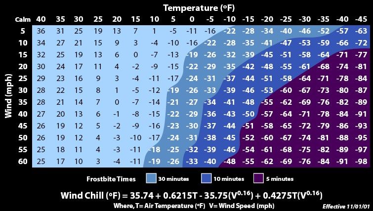
Table 6-18: Wind Chill Temperature Index ................................................................................................. 32
Table 7-1: Westminster Building Values ..................................................................................................... 33
Table 7-2: Westminster Hazard Rankings ................................................................................................... 34
Table 7-3: Estimated Damage from Flooding Event ................................................................................... 35
Table 7-4: High Hazard Dams in Westminster ............................................................................................ 35
Table 7-5: Estimated Damage from Snow/Blizzard Event .......................................................................... 37
Table 7-6: Estimated Damage from Tornado Event.................................................................................... 39
Table 8-1: Worcester County Climate Change – Precipitation ................................................................... 40
Table 8-2: Worcester County Climate Change – Temperature ................................................................... 40
Table 9-1: Existing Mitigation Measures..................................................................................................... 42
Table 10-1: Westminster Mitigation Actions .............................................................................................. 47
ivHazard Mitigation Plan
Westminster, Massachusetts
LIST OF FIGURES
Figure 6-1: Massachusetts Seismic Hazard with 2% Probability of Exceedance in 50 Years ...................... 19
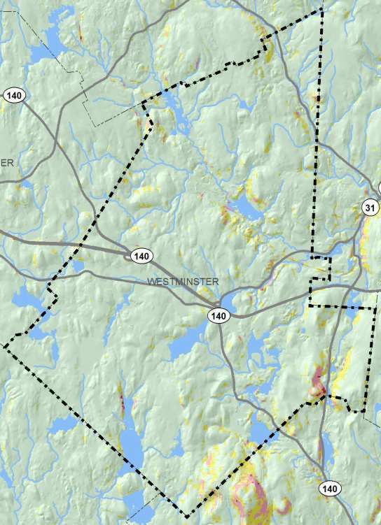
Figure 6-2: Slope Stability Map of Westminster, MA ................................................................................. 21
LIST OF APPENDICES
Appendix A – Hazard Mitigation Planning Team Meeting Agendas and Sign-In Sheets
Appendix B – Critical Facilities Map
Appendix C – FEMA Flood Zones Map
Appendix D – FEMA Flood Zones Map Overlaid with Critical Facilities
vHazard Mitigation Plan
Westminster, Massachusetts
1.0 INTRODUCTION
1.1 FEDERAL DISASTER MITIGATION ACT
Congress enacted the Disaster Mitigation Act of 2000 (DMA 2000) on October 10, 2000. The bill was signed
into law on October 30, 2002, creating Public Law 106-390. Under the law, all communities are required
to have a Hazard Mitigation Plan in place to qualify for future federal mitigation funding and the plan must
be updated in five-year intervals. This requirement does not affect disaster assistance funding.
The Federal Emergency Management Act (FEMA) administers hazard mitigation planning and grants
programs in Massachusetts in collaboration with the Massachusetts Emergency Management Act
(MEMA).
1.2 HAZARD MITIGATION PLAN PURPOSE
This plan identifies natural hazards impacting the Town of Westminster, assesses the town’s vulnerability
to these hazards and recommends actions to mitigate the effects identified hazards may have on the
town.
This Hazard Mitigation Plan has been prepared based on FEMA’s “Local Mitigation Planning Handbook”
(March 2013) and was designed to meet the requirements of DMA 2000. The Town of Westminster
received a grant in conjunction with the Municipal Vulnerability Preparedness Program. Westminster and
BETA Group, Inc. (BETA) developed this Plan to focus specifically on the local issues affecting the town.
Objectives of this plan include the following:
Detail the planning process and identify members of the local Hazard Mitigation Planning Team
Create hazard profiles for each hazard with a description and prioritization
Prepare an inventory of critical facilities
Complete a risk assessment for each specified hazard and estimate potential losses
Identify existing hazard mitigation measures already in place
Develop proposed mitigation actions and strategies based on risk assessment
Prepare an implementation schedule with procedures ensuring the plans implementation,
updating, and revision every five years
Detail the process where Westminster formally adopts the plan
Implementation of this plan prior to a major disaster occurring can help reduce property damage, loss of
life, and interruption of critical services. In addition, adoption of this plan allows funding through FEMA
for additional mitigation funding.
2.0 PLANNING PROCESS
2.1 LOCAL HAZARD MITIGATION PLANNING TEAM
A local hazard mitigation team of town employees with assistance from BETA Group, Inc. was created to
develop the Hazard Mitigation Plan.
The planning team consists of the following members:
1Hazard Mitigation Plan
Westminster, Massachusetts
Table 2-1: Hazard Mitigation Planning Team
Member Name Affiliation
Kyle Butterfield Fire Chief
Joshua Hall DPW Director
Pat Haley Assistant DPW Director
The planning team brings together people with varying backgrounds, expertise, and experience in hazards
affecting the residents and businesses of Westminster. Each member brings an important viewpoint to
the planning process and interest to ensure the plan is implemented and reflects the needs of the town.
The planning team met on the following dates: March 13, 2020 & March 16, 2021.
2.2 PLANNING PROCESS SUMMARY
The purpose of the meetings was to introduce the planning team, gather information on local hazard
issues and sites, and identify vulnerable populations and areas for each associated hazard. Later meetings
focused on discussion of existing mitigation practices and developing new mitigation actions or measures.
In general, the following steps were taken during the planning process.
1. Identify potential hazards that could affect Westminster;
2. Inventory critical facilities in town;
3. Map hazards and determine potential high hazard locations;
4. Conduct a vulnerability assessment of infrastructure;
5. Identify populations most vulnerable to specified hazards;
6. Outline existing hazard mitigation measures in place; and
7. Propose and evaluate feasibility of new hazard mitigation measures.
Some of this information was also gathered during the Community Resilience Building Workshop, held on
March 16, 2021. Members of the community collaborated and informed BETA of many recent town
hazards, critical facilities and more. Information and recommendations from previous studies completed
by the town were also reviewed and incorporated into the Hazard Mitigation Plan. Information included
in the Municipal Vulnerability Preparedness Program were included in Proposed Mitigation Actions in
Section 10.
The Westminster Planning Board is the primary town agency responsible for regulating development in
the town. Participation by the Town Planner on the Hazard Mitigation Planning Team ensured feedback
to the Planning Board.
2.3 PUBLIC PARTICIPATION
A Public Listening Session was hosted on April 20 th, 2021. Input received from the Public Listening Session
is included in the Risk Assessment portion of this plan. A copy of the plan has been posted on the Town’s
website with language inviting comments through July of 2021. Any input will be included as an appendix
to the plan.
A copy of the plan was sent to the Town of Gardner and the City of Fitchburg for review and comment.
3.0 MUNICIPAL VULNERABILITY PREPAREDNESS
Westminster received a municipal vulnerability preparedness planning grant from the Executive Office of
Energy and Environmental Affairs to conduct a community resilience building workshop and complete a
2Hazard Mitigation Plan
Westminster, Massachusetts
report documenting workshop findings. Findings from the workshop were incorporated by the Hazard
Mitigation Planning Team into this plan.
3.1 COMMUNITY RESILIENCE BUILDING WORKSHOP
16 participants from various departments and boards attended a six-hour workshop session on March 16,
2021 to identify resiliency opportunities that addressed town vulnerabilities identified as part of the
workshop. A list of participants and their corresponding departments is shown in Table 3-1 below.
Table 3-1: Workshop Participants
Name Affiliation
Joshua Hall DPW Director
Patrick Haley Assistant DPW Director
Kyle Butterfield Fire Chief
Robert Francis Local Business Owner, Resident and Private Dam Owner
Jon Wyman Chair of Planning Board
Mark Hawke Town Administrator
ML Altobelli Agricultural Committee
Ann Loree Health Agent
John Deline Deputy Commissioner of Water Supply (Fitchburg)
Ralph LeBlanc Chief of Police
Stephanie Lahtinen Assistant to Town Administrator
Ned LaFortune Local Business Owner and Resident
Lee Pelletier Wyman Lake Association
Stephen Wallace Town Planner
Andy Dennehy BETA Group Inc
Mary Beth Cops BETA Group Inc
Katelyn Burke BETA Group Inc
Attendees were divided into two small working groups. In these groups, they identified the top four
hazards facing Westminster; vulnerable infrastructure, societal and environmental assets in the
community; and developed a list of actions to mitigate impacts of hazards on vulnerable assets. The small
groups then reported their top actions to the large group for discussion and consensus on the top overall
actions. Overall priority actions determined in the workshop were:
Drought Public Outreach
Culvert Study/ Upsizing as appropriate
Bridge Study/ Rehabilitation or replacing as appropriate
Tree Management Program
Protection of Communication System at Safety Complex
Hydrological Study of Rivers, streams, lakes and ponds
Generator @ priority buildings (Esp DPW, senior center)
3Hazard Mitigation Plan
Westminster, Massachusetts
Planning With national Grid to discuss backup/rerouting capabilities in event of Power outage
Outreach/Education for water Conservation
Look into Beaver/Tick/Mosquito control and prevention – Natural resources program
Investigate best monitoring/ enforcement for water usage during restricted periods and leak
identification.
These actions are included in Table 10-1 and a report documenting workshop findings was submitted to
the Executive Office of Energy and Environmental Affairs.
4.0 COMMUNITY PROFILE
4.1 GEOGRAPHY
The Town of Westminster, Massachusetts is located in Worcester County, 40 miles northwest of Boston
and 12 miles north of Worcester. It is bordered by Ashburnham to the north, Fitchburg to the east,
Hubbardston to the southwest, Princeton to the southeast, and Gardner to the west. The town
encompasses 37 square miles, of which 1.8 square miles is water.
Westminster is part of a higher altitude region with a few elevated regions, including part of Mt.
Wachusett. Westminster has multiple bodies of water, including several reservoirs, and rivers within the
community. Larger bodies of water within the town include Meetinghouse Pond, Wyman Pond, Round
Meadow Pond, Crocker Pond, Muddy Pond, Greenwood Pond, Partridge Pond, Upper Reservoir, Minott
Pond, and Noyes Pond. Major rivers include the Whitman River, Phillips Brook, Wymans Brook, and Flag
Brook.
4.2 CLIMATE
Westminster averages 48 inches of rain each year and an average of 69 inches per snow. Average
temperatures range from highs in the high 70’s (°F) in the summer months to lows in the low teens (°F) in
the winter months1.
4.3 DEMOGRAPHICS
The town’s population has grown from 6,904 in the 2000 US Census to 7,277 in the 2010 US Census and
estimated to be 7,997 in 2019. Current population density is approximately 205.4 people per square mile.
Based on 2010 US Census information, Westminster is a largely white community, with 95.9% identifying
as such. Hispanic or Latinos is the largest minority group at 3.4%. Average household size is 2.71 people
with 34.7% of households with children under 18 years of age. The median age is 34 years with 10.4% of
the population over the age of 65 and 27.5% of the population under the age of 182.
4.4 INFRASTRUCTURE
Westminster has approximately 8.6 miles of state roads, and 41.6 miles of local roadways3. The Town is
accessible via Route 2, and Route 2A, which run in a general east-west direction Route 140, Route 31, and
Route 12 which run in a general north-south direction
The Westminster Council on Aging provides bus service Monday- Friday for $2 round trip within
Westminster and for $3 out of Town limits; pick up service is for senior citizens and disabled individuals.
1
Best Places to Live https://www.bestplaces.net/climate/zip-code/massachusetts/north_attleboro/02760
2
US Census https://factfinder.census.gov/faces/nav/jsf/pages/community_facts.xhtml
3
MassGIS
4Hazard Mitigation Plan
Westminster, Massachusetts
The Westminster Department of Public Works (WDPW) is a community water supply that receives 100%
of its water supply from the City of Fitchburg. Accordingly, the WDPW is classified as a consecutive water
system. Westminster's source of finished water is obtained from the City of Fitchburg's Regional Filtration
Plant located at 18 Hager Park Road in Westminster. The raw water for the filtration plant comes from
Meetinghouse Pond (a terminal reservoir), is filtered, disinfected, fluoridated, and pH adjusted for
corrosion control. This treated water flows from the filtration plants clearwells into a 2 MG buried storage
tank that is also located at Hager Park. Water supply flows via gravity from here though a transmission
main into the City of Fitchburg.
Westminster receives gas from Unitil Gas Utilities and electric service is provided by Fitchburg Electric
Department. Communications services are provided by Verizon and Comcast.
4.5 HISTORIC PROPERTIES
The National Register of Historic Places lists historic places and areas worthy of preservation is part of a
program to coordinate and support private and public efforts to identify, evaluate and protect America’s
historic and archaeological resources. The following areas in Westminster are listed in the Register of
Historic Places for Massachusetts:
Westminster Village – Academy Hill Historic District
Ahijah Wood House
Ezra Wood-Levi Warner Place
Nathan Wood House
5.0 CRITICAL INFRASTRUCTURE
The planning team identified numerous building, structures, or locations that are vital to hazard response
efforts or would create a secondary disaster if a hazard were to impact it. Critical facilities were identified
using local knowledge and expertise from the planning team in combination with MassGIS data. These
facilities are listed in Table 5-1 below and shown in the map in Appendix B.
Critical facilities were divided into the following categories:
Emergency Response Facilities
Essential, Non-Emergency Response Facilities
Dams
Facilities to Protect
Schools/Daycares
Historic Districts
Table 5-1: Critical Facilities
Critical Facility Address Facility Type
Emergency Response Facilities
Westminster Police Station 7 South Street Police Station
Westminster Fire Station 7 South Street Fire Station
Westminster DPW 2 Oakmont Avenue Department of Public Works
Meetinghouse School 8 South Street School/ Emergency Shelter
Oakmont Regional High School 9 Oakmont Drive School/ Emergency Shelter
Overlook Middle School 10 Oakmont Drive School/ Emergency Shelter
Westminster Elementary School School/ Emergency Shelter
9 Academy Hill Road
(Primary)
5Hazard Mitigation Plan
Westminster, Massachusetts
Town Facility/ Emergency
Westminster Senior Center 69 West Main Street
Shelter
Westminster Public Safety Building 7 South Street Town Facility
Westminster Communications
18 Ellis Road Town Facility
Building/Equipment
Essential, Non-Emergency Response Facilities
Meetinghouse Pond Gate Valve W. Princeton Road
Old Mill Restaurant 69 State Road East Restaurant
Vincent’s Grocery Store Main St Grocery Store
Advance Coatings Company 42 Depot Road
Fitchburg Gas & Elec. LNG Facility 122 State Road West
Fitchburg/Westminster Sanitary
Fitchburg Road
Landfill
Guilford Rail Bridge #1 Rail Line & State Road East
Guilford Rail Bridge #2 Rail Line & Oakmont Avenue
Guilford Rail Bridge #3 Rail Line & Swamp
ITW (Illinois Tool Works, Inc.) 180 State Road East
MassDOT Maintenance Depot 400 Simplex Drive
MBTA Wachusett Station Layover
Theodore Drive
Facility
NS AJO Holdings, Inc. Turnpike Rd/20 Authority Drive
Ranor Incorporated 1 Bella Drive
Tyco Simplex Grinnell 50 Technology Drive
Unitil Gas Valve State Road East
Verizon 18 Elliott Street
Wachusett Animal Hospital and Pet
29 Theodore Drive
Retreat
Wachusett Brewing Company 175 State Road East
Wachusett Mountain Ski Area Wachusett Mountain Ski Area
Walmart Warehouse 95 Aubuchon Drive
Westminster Pharmacy Main Street
Westminster Water Pumping Station 18 Hager Park Road Water Supply
Regional Water Treatment Facility 18 Hager Park Road Water Supply
Fitchburg Water Building Narrows Road Water Supply
Westminster Water Pumping Station South Street Water Supply
Ellis Road Water Tank 18 Ellis Road Water Supply
Shady Ave Water Tank Goodridge Drive Water Supply
Kendall Court Pumping Station Kendall Court Water Supply
Ellis Road Sewer Pumping Station Ellis Road Sewer System
Frog Hollow Road Sewer Pumping
Frog Hollow Road Sewer System
Station
Whitman River Sewer Pumping
State Road East Sewer System
Station
Whitman River in-line Sewer Storage State Road East Sewer System
Narrows Road Sewer Pumping
Narrows Road Sewer System
Station
Val Road Sewer Pumping Station Val Road Sewer System
Wachusett Road Sewer Pumping
Wachusett Road Sewer System
Station
6Hazard Mitigation Plan
Westminster, Massachusetts
Mile Hill Road Sewer Pumping
Mile Hill Road Sewer System
Station
Westminster Town Hall 11 South Street Town Facility
Forbush Memorial Library 118 Main Street Town Facility
National Grid 1 State Road West Electric Substation
National Grid Depot Road Electric Substation
Pinetree Power Fitchburg, Inc. 170 Fitchburg Road Power Supply
Crocker Pond Hydro-electric South Ashburnham Road Power Supply
RCI 101 Fitchburg Road Power Supply
Solar Panels, Aubuchon Hardware 100 Simplex Drive Power Supply
Dams
Holmes Park Pond Dam Miles Street Dam
Upper Reservoir Dam Whitney Street Dam
Smith Pond Dam Worcester Road/Patricia Road Dam
Wyman Pond Compensating
Narrows Road Dam
Reservoir Dam
Meetinghouse Pond Dam (Fitchburg) W. Princeton Road Dam
Wachusett Reservoir Dam (Fitchburg) Park Road Dam
Burnt Mill Pond Dam (Private) Btwn. Rt 2A and Ellis Road Dam
Crocker Pond Dam (Private) S. Ashburnham Road Dam
Ellis Pond Dam (Private) Ellis Road Dam
Minott Pond Dam (Private) Minott Road Dam
Narrows Mill Pond Dam (Private) Depot Road Dam
Noyes Pond Dam (Private) Lanes Road/Davis Road Dam
Pierce Pond Dam (Private) Shady Avenue Dam
Rice Meadow Fly Pond Dam (Private) Notown Road Dam
Round Meadow Pond Dam (Private) Merriam Road Dam
Storage Pond Dam (Private) Simplex Drive Dam
Westminster Reservoir Dam (Private) S. Ashburnham Road Dam
Crocker Fish Pond Dam (State) Fitchburg Road Dam
Crow Hills Pond Dam (State) Fitchburg Road Dam
Upper Crow Hills Pond Dam (State) Fitchburg Road Dam
Facilities to Protect
The Wellington House 5 Meeting House Road Assisted Living
Senior Housing (being developed) Community Way Senior Housing
Daniel Irving Medical Practice South Street Medical Facility
On-Site Academy 219 Bragg Hill Road Medical Facility
Recovery Centers of America 9 Village Inn Road Medical Facility
Westminster Family Practice 116 Main Street Medical Facility
Sawyer Miller-Masciarelli Funeral End of Life Facility
123 Main Street
Home
Cemetery Department Narrows Road Town Facility
Mount Pleasant Cemetery Ellis Road Cemetery
Whitmanville Cemetery South Ashburnham Road Cemetery
Woodside Cemetery Narrows Road Cemetery
100 Simplex Drive Building 100 Simplex Drive Freight/HAZMAT
Advance Coatings Company 42 Depot Road Freight/HAZMAT
Cumberland Farms Gas Station 68 Main Street Freight/HAZMAT
DS Smith Packaging 100 Simplex Drive Freight/HAZMAT
Fitchburg Gas & Elec. Lng Facility 122 State Road West Freight/HAZMAT
7Hazard Mitigation Plan
Westminster, Massachusetts
Fitchburg Welding Co., Inc. 4 Depot Road Freight/HAZMAT
ITW (Illinois Tool Works, Inc.) 180 State Road East Freight/HAZMAT
JP Metal Finishing 1 Leominster St Freight/HAZMAT
MassDOT 400 Simplex Drive Freight/HAZMAT
Mayhew Basque Plastics, LLC. 100 Simplex Drive Freight/HAZMAT
Pan-American Railroad Line Theodore Drive Freight/HAZMAT
Pinetree Power Fitchburg, Inc. 2 Rowtier Drive Freight/HAZMAT
Ranor Incorporated 1 Bella Drive Freight/HAZMAT
Regional Water Treatment Facility 18 Hager Park Road Freight/HAZMAT
Pan-American Railroad Line Theodore Drive Freight/HAZMAT
Pinetree Power Fitchburg, Inc. 2 Rowtier Drive Freight/HAZMAT
Ranor Incorporated 1 Bella Drive Freight/HAZMAT
Regional Water Treatment Facility 18 Hager Park Road Freight/HAZMAT
Seaboard Folding Box Co., Inc. 100 Simplex Drive Freight/HAZMAT
VERC Enterprises (Gas Station) 21 Village Inn Road Freight/HAZMAT
Verizon 18 Elliott Street Freight/HAZMAT
Wachusett Brewing Company 175 State Road East Freight/HAZMAT
Wachusett Mountain Ski Area Wachusett Mountain Ski Area Freight/HAZMAT
Walmart Warehouse 95 Aubuchon Drive Freight/HAZMAT
Westminster Depot 4 Theodore Drive Freight/HAZMAT
Westminster Landfill Fitchburg Road Freight/HAZMAT
Schools/Daycares
Appleseed Academy of Child 138 Main Street
Child Care
Development
Neighborhood Family Child Care 319 Knower Rod Child Care
Karen Bourgeois 20 Kurikka Place Child Care
Hannelore Brown 28 Colony Road Child Care
Jennifer B. Condon 74 Carter Road Child Care
Deborah Davis 114 Ellis Road Child Care
Gretchen B. Faford 134 State Road West Child Care
Vivien Forbes 201 Ellis Road Child Care
Nancy Jean Gaudet 12 Whitney Street Child Care
Victoria Kimber 18 Fenno Drive Child Care
Jennifer M Konich 62 Knower Road Child Care
Amanda Palmer-Rosado 319 Knower Road Child Care
CAPS Collaborative 2 Narrows Rd. Suite 105 School
Meetinghouse School 8 South Street School
Montachusett Regional Vocational Westminster Street School
Technical School
Oakmont Regional High School 9 Oakmont Drive School
Overlook Middle School 10 Oakmont Drive School
Westminster Elementary School 9 Academy Hill Road School
CAPS Collaborative 2 Narrows Rd. Suite 105 School
Historic Districts
Bacon, Adams, Main, Dawley,
Westminster Village-Academy Hill
Academy Hill, Leominster, and Historic District
Historic District
Pleasant Sts.
Ahijah Wood House 174 Worcester Rd. Historic Building
Ezra Wood-Levi Warner Place 165 Depot Rd. Historic Building
Nathan Wood House 164 Depot Rd. Historic Building
8Hazard Mitigation Plan
Westminster, Massachusetts
6.0 RISK ASSESSMENT
The risk assessment includes a summary of natural hazards that could occur within the Town of
Westminster. This section also includes a vulnerability assessment that analyzes the potential damage
that could result from hazard events.
BETA compiled the most recently available hazard data and met with the planning team to complete the
risk assessment.
6.1 OVERVIEW OF HAZARDS AND IMPACTS
All natural hazards have the potential to cause property damage and loss of human life, as well as limit
access to essential services in a community, including potable water, wastewater collection, and electrical
power.
Westminster identified a number of natural hazards that have occurred or could occur in town and
analyzed the hazard risk for each. Analysis included determining the likely frequency, severity, and area
of impact for each hazard.
The methodology used to classify each category was based on the following criteria:
Table 6-1: Hazard Classification Index
Classification Description
Frequency
Very Low Events that occur less often than once in 100 years
Low Events that occur from once in 50 years to once in 100 years
Medium Events that occur from once in 5 years to once in 50 years
High Events that occur more frequently that once in 5 years
Severity
Limited and scattered property damage, limited damage to public infrastructure and
Minor
essential services not interrupted, limited injuries or fatalities.
Scattered major property damage, some minor infrastructure damage, essential
Serious
services are briefly interrupted, some injuries and/or fatalities
Widespread major property damage, major public infrastructure damage (up to
Extensive several days for repairs), essential services are interrupted from several hours to
several days, many injuries and/or fatalities.
Area of Impact
Negligible Less than 10% of town impacted or single-point occurrence
Limited 10% - 25% of town impacted or limited single-point occurrences
Significant 25% - 75% of town impacted or frequent single-point occurrences
Extensive 75% - 100% of town impacted or consistent single point occurrences
Based on the town’s ranking of each category, an overall risk assessment for each hazard was determined
and is discussed in Section 6.0. Table 6-2 below summarizes the hazard risks for Westminster.
Table 6-2: Westminster’s Hazard Risk Summary
Hazard Frequency Severity Area of Impact
9Hazard Mitigation Plan
Westminster, Massachusetts
Flood High Minor Limited
Dam Failure Low Extensive Significant
Hurricane/Tropical Storm High Serious Extensive
Nor’easter High Serious Extensive
Earthquake Low Extensive Significant
Landslide/Erosion Medium Minor Negligible
Snow & Blizzard High Serious Extensive
Ice Storm Medium Extensive Extensive
Wildland Fire Medium Serious Limited
Major Urban Fire Low Minor Negligible
Thunderstorm High Serious Extensive
High Wind High Minor Significant
Tornado Low Serious Limited
Drought High Serious Extensive
Extreme Temperature High Minor Extensive
6.2 FLOOD RELATED HAZARDS
Flooding was not the most prevalent natural hazard identified by local officials in Westminster. Flooding
in Westminster typically occurs in isolated areas more often during the summer months when severe
thunderstorm, rainstorms, and hurricanes occur in the Northeast United States. Flooding can also occur
when winter snows melt, causing the rivers to overflow their banks, or when heavy wet snows backup
roadside drainage systems causing flooding in low lying areas.
6.2.1 HAZARD OVERVIEW
Westminster is impacted by several bodies of water including but not limited to the Whitman River, the
Phillips Brook, Lake Wampanoag, Whitman Reservoir, Crocker Pond and several smaller ponds, streams,
and wetland areas.
Given the topography of the Town, flooding is localized to these bodies of water and typically have
minimal impact to the Town at large.
6.2.2 SIGNIFICANT HAZARD EVENTS
There have been a number of major events that have impacted flooding in Westminster over the last 50
years. Events include:
September 1954 (Hurricane Edna)
August 1955 (Hurricane Diane)
September 1960 (Hurricane Donna)
March 1968
August 1991 (Hurricane Bob)
October 1996
June 1998
April 2001
October 2005
November 2005
March 2010
August 2011 (Tropical Storm Irene)
October 2012 (Hurricane Sandy)
10Hazard Mitigation Plan
Westminster, Massachusetts
Local data for previous flooding occurrences are not collected by Westminster. The best available data is
for Worcester County through the National Climatic Data Center. Worcester County experienced 77 flood
events from 2000 to 2020. No deaths or injuries were reported. Total reported property damage for
flooding in Worcester County in that time frame was $11.9 million.
6.2.3 HAZARD LOCATION
No potential flood hazard areas were identified from FEMA’s National Flood Hazard Layer made available
by MassGIS. However, there were locations identified as flooding often during the MVP Workshop.
Additionally, FEMA has an older layer called “Q3 flood zones” based on the Flood Insurance Rate Maps
(FIRM),made available by MassGIS are shown on the map in Appendix C and flood zone definitions are
listed below. The Q3 flood data were developed to support floodplain management and planning activities
but do not replace the official paper FIRMs.
Zone A (1% annual chance): Areas that correspond to the 100-year floodplains. Detailed hydraulic
analyses have not been performed in these areas and no base flood elevations (BFEs) or depths
are shown.
Zone AE and A1-130 (1% annual chance): Areas that correspond to the 100-year floodplains are
determined using detailed hydraulic analysis. BFEs are shown within these zones.
Zone X500 (0.2% annual chance): Areas that correspond to the 500-year floodplains that are
determined by approximate methods. No BFEs or depths are shown.
Zone VE (1% annual chance): Areas that correspond to the 100-year coastal floodplains and have
additional hazards associated with waves 3-foot or greater in height.
A list of critical infrastructure at risk from flooding during the 100-year storm is listed in Table 6-3. Critical
infrastructure locations in relation to FEMA floodplains are shown on the map in Appendix D.
Table 6-3: Critical Infrastructure in Flood Plain
Critical Infrastructure Location Flooding Risk River
Whitman River Sewer Pumping Station State Road East 100-year Whitman River
Narrows Road Sewer Pumping Station Narrows Road 100-year Wyman Pond
Mile Hill Road Sewer Pumping Station Mile Hill Road 100-year Ten Mile River
Crocker Pond Recreation Area Well South Ashburnham Road 100-year Whitman River
6.2.4 DAM AND DAM FAILURE
The Massachusetts Department of Conservation and Recreation (DCR) Office of Dam Safety is responsible
for regulating dams in Massachusetts. There are over 2,900 publicly and privately owned dams in
Massachusetts. To be regulated, dams must be greater than 6 feet tall and have storage capacity greater
than 15 acre-feet. DCR classifies regulated dams as high, significant, or low hazard. These classifications
are defined below.
DCR Dam Hazard Classification
High: Dams located where failure will likely cause loss of life and serious damage to home(s),
industrial or commercial facilities, important public utilities, main highway(s) or railroad(s)
Significant: Dams located where failure may cause loss of life and damage homes(s), industrial
or commercial facilities, secondary highway(s) or railroad(s) or cause interruption of use or
service of relatively important facilities.
Low: Dams located where failure may cause minimal property damage to others. Loss of life is
not expected.
11Hazard Mitigation Plan
Westminster, Massachusetts
Under 302 CMR 10.00 Dam Safety, low hazard dams shall be formally inspected every ten years, significant
hazard dams every five years, and high hazard dams every two years.
Dam failure can occur from structural failure, independent of a hazard event, or from impacts from a
hazard event. Dam failures are infrequent but can result in serious property damage and loss of life. The
number of casualties and amount of property damage depends of numerous factors including, amount of
warning given to downstream residents, number of people living or working in the inundation zone and
the number of buildings in the inundation zone.
There are twenty dams in Westminster. Dams are shown on the map in Appendix B and summarized in
Table 6-4. Hazard rating potential has no relationship to the current structural integrity, operational
status, flood routing capability, or safety condition of the dam.
Table 6-4: Dams Located in Westminster
Hazard
Dam Name Impoundment Receiving Waterbody Owner
Potential
Burnt Mill Pond Burnt Mill Pond - Private Low
Crocker Fish Pond Dam Crocker Fish Pond Whitman River State Low
Crocker Pond Dam Crocker Pond Flag Brook Private High
Crow Hills Pond Dam Crow Hills Pond Flag Brook State Significant
Ellis Pond Dam Partridge Pond Burnt Mill Pond Private Significant
Holmes Park Pond Dam Holmes Park Pond - Westminster -
Meetinghouse Pond Dam Meetinghouse Pond Smith Brook Fitchburg Significant
Minott Pond Dam Minott Pond Upper Reservoir Private Significant
Narrows Mill Pond Dam Narrows Mill Pond - Private -
Noyes Pond Dam Noyes Pond - Private Significant
Pierce Pond Dam Greenwood Pond Mahoney Brook Private Significant
Rice Meadow Fly Pond Dam Rice Meadow Pond - Private Low
Round Meadow Pond Dam Round Meadow Pond - Private Significant
Smith Pond Dam Smith Reservoir Smith Brook Westminster -
Storage Pond Dam Storage Pond - Private -
Upper Crow Hills Pond Dam Upper Crow Hills Pond Crow Hills Pond State Significant
Upper Reservoir Dam Upper Reservoir Wrights Reservoir Westminster Significant
Wachusett Reservoir Dam Wachusett Lake Wyman Pond Fitchburg Significant
Westminster Reservoir Dam Whitmanville Reservoir Whitman River Private High
Wyman Pond Compensating
Wyman Pond - Fitchburg High
Reservoir Dam
There have not been any dam failures in Westminster, and the town regularly works with the city of
Fitchburg and private dam owners to ensure inspections and maintenance schedules are up to date.
12Hazard Mitigation Plan
Westminster, Massachusetts
6.3 HURRICANES AND TROPICAL STORMS
6.3.1 HAZARD OVERVIEW
Hurricanes begin as tropical storms over the warm moist waters of the Atlantic Ocean, off the coast of
West Africa, and over the Pacific Ocean near the equator. As the moisture evaporates, it rises until
enormous amounts of heated, moist air are twisted high in the atmosphere. The winds begin to circle
counterclockwise north of the equator or clockwise south of the equator. The center of the hurricane is
called the eye.
The National Hurricane Center classifies tropical cyclones into different categories based on the storm’s
intensity and wind speed. The weakest are tropical depressions, which are organized systems of clouds
and thunderstorms with a defined surface circulation and sustained winds of 25-33 mph. A tropical storm
is a named event which has sustained winds of 34-73 mph.
If sustained winds reach 74 mph or greater, the storm becomes a hurricane. The Saffir-Simpson scale ranks
hurricanes based on sustained wind speeds—from Category 1 (74 to 95 mph) to Category 5 (156 mph or
more). Category 3, 4, and 5 hurricanes are considered “major” hurricanes. Hurricanes are categorized
based on sustained winds; wind gusts associated with hurricanes may exceed the sustained winds and
cause more severe localized damage.
Table 6-5 shows the Saffir-Simpson Hurricane Scale which is used to organize hurricanes into their 5
different categories as well as the classifications for tropical cyclones4.
Table 6-5: Saffir-Simpson Hurricane Scale
Saffir-Simpson Scale for Hurricane Classification
Wind Speed Wind Speed
Strength Typical Damage
(Kts) (mph)
Some damage: Well-constructed frame homes could have damage to roof,
shingles, vinyl siding and gutters. Large branches of trees will snap and
Category 1 64- 82 74- 95
shallowly rooted trees may be toppled. Extensive damage to power lines and
poles likely will result in power outages that could last a few to several days
Strength Wind Speed Wind Speed Typical Damage
(Kts) (mph)
Extensive damage: Well-constructed frame homes could sustain major roof
and siding damage. Many shallowly rooted trees will be snapped or uprooted
Category 2 83- 95 96-110
and block numerous roads. Near-total power loss is expected with outages
that could last from several days to weeks.
Devastating damage: Well-built framed homes may incur major damage or
removal of roof decking and gable ends. Many trees will be snapped or
Category 3 96-113 111-130
uprooted, blocking numerous roads. Electricity and water will be unavailable
for several days to weeks after the storm passes.
4
National Hurricane Center, https://www.nhc.noaa.gov/aboutsshws.php
13Hazard Mitigation Plan
Westminster, Massachusetts
Catastrophic damage: Well-built framed homes can sustain severe damage
with loss of most of the roof structure and/or some exterior walls. Most
Category 4 114-135 131-155 trees will be snapped or uprooted and power poles downed. Fallen trees and
power poles will isolate residential areas. Power outages will last weeks to
possibly months. Most of the area will be uninhabitable for weeks or months
Catastrophic damage: A high percentage of framed homes will be destroyed,
with total roof failure and wall collapse. Fallen trees and power poles will
Category 5 >135 >155
isolate residential areas. Power outages will last for weeks to possibly
months. Most of the area will be uninhabitable for weeks or months.
Tropical Cyclone Classification
Tropical Depression 20-34kts
Tropical Storm 35-63kts
Hurricane 64+kts or 74+mph
6.3.2 SIGNIFICANT HAZARD EVENTS
According to the Northeast States Emergency Consortium (NESEC), 25 hurricanes and 14 tropical storms
have impacted New England since 1900. Of the 25 hurricanes to impact New England, 9 made landfall and
7 of those were classified as a category 2 or 3.
Table 6-6 lists hurricanes that have affected the region since 1938.
Table 6-6: Hurricanes/Tropical Storms in Westminster
Hurricane/Tropical Saffir/Simpson
Date
Storm Name Category
Great New England
September 21, 1938 Category 3
Hurricane of 1938
Great Atlantic September 14-15, 1944 Category 3
Hurricane
Carol August 31, 1954 Category 3
Edna September 11, 1954 Category 3
Diane August 18-20, 1955 Tropical Storm
Donna September 12, 1960 Category 2
Belle August 9-10, 1976 Minor Storm
Gloria September 27, 1985 Category 2
Bob August 19, 1991 Category 2
Bertha July 12-13, 1996 Tropical Storm
Floyd September 18, 1999 Tropical Storm
Irene August 28, 2011 Tropical Storm
Sandy October 29-30, 2012 “Super Storm”
Jose September 20, 2017 Tropical Storm
14You can also read