MUNICIPAL VULNERABILITY PREPAREDNESS (MVP) PLAN - SUBMITTED BY June, 2019
←
→
Page content transcription
If your browser does not render page correctly, please read the page content below
MUNI CIPALVUL
            NERABIL
                  ITY
PREPAREDNESS(MVP)PL
                  AN

                  S
                  UBMI
                     TTE
                       DBY

            Ci
             vilandSt
                    ruc
                      tur
                        alEn i
                             neer
                                s

                     J
                     une,
                        2019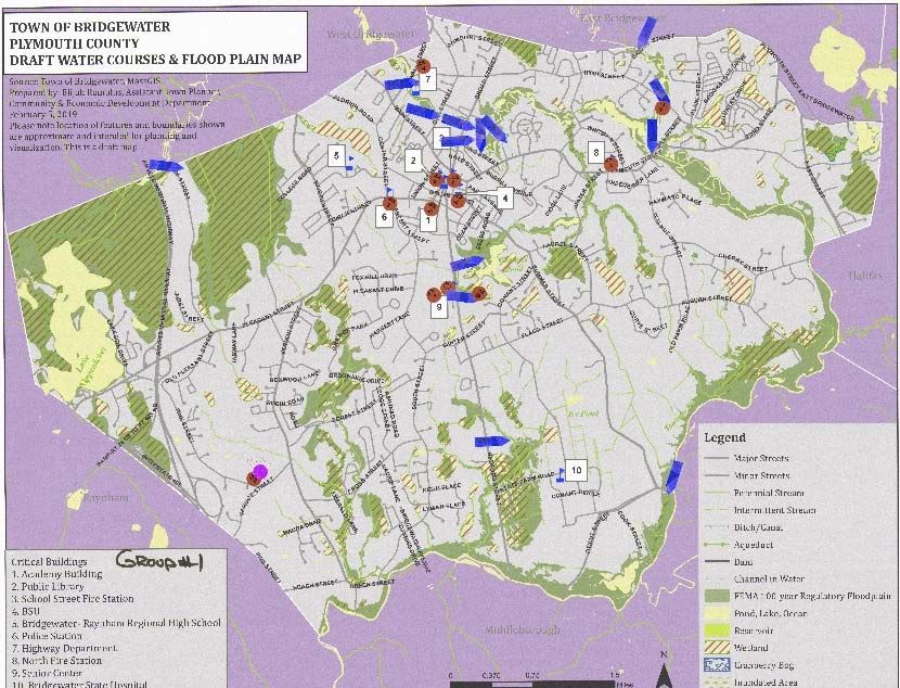
Municipal Vulnerability Preparedness (MVP) Plan
Bridgewater, Massachusetts June 2019
TABLE OF CONTENTS
EXECUTIVE SUMMARY ......................................................................................................................... 1
REPORT CITATION, WORKSHOP PARTICIPANTS, AND ACKNOWLEDGEMENTS ...................................... 5
I. OVERVIEW ................................................................................................................................. 6
II. SUMMARY OF FINDINGS .......................................................................................................... 13
III. CURRENT CONCERNS AND CHALLENGES PRESENTED BY HAZARDS ........................................... 21
IV. SPECIFIC CATEGORIES OF CONCERNS AND CHALLENGES ........................................................... 23
V. CURRENT STRENGTHS AND ASSETS IN BRIDGEWATER .............................................................. 29
VI. TOP RECOMMENDATIONS TO IMPROVE RESILIENCE TO HAZARDS ........................................... 34
ENDNOTES ......................................................................................................................................... 37
TABLES
Table 1: Recommended Action Steps to Improve Resiliency to Climate Change in Bridgewater ................ 3
Table 2: Vulnerable Areas and Attributes for Bridgewater based on Climate Change Projections ........... 14
Table 3: Current Strengths and Assets in Bridgewater related to Climate Change Resiliency ................... 29
Table 1: Recommended Action Steps to Improve Resiliency to Climate Change in Bridgewater .............. 34
FIGURES
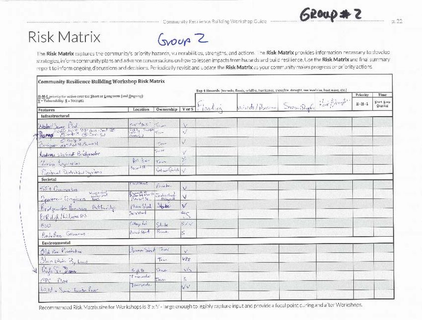
Figure 1: Typical Risk Matrix used by participants during workshops ........................................................ 22
Figure 2: Town wide Map identifying specific vulnerable areas................................................................. 22
APPENDICES
APPENDIX A ‐ COMPLETED RISK MATRIX
APPENDIX B ‐ MAP OF BRIDGEWATER INFRASTRUCTURAL ASSETS
APPENDIX C ‐ MAP OF BRIDGEWATER SOCIETAL AND ENVIRONMENTAL ASSETS
APPENDIX D ‐ WORKSHOP MATERIALS
Page i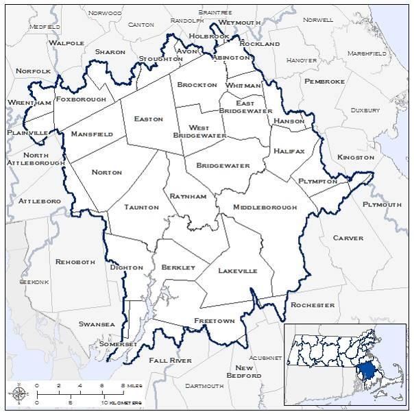

Municipal Vulnerability Preparedness (MVP) Plan
Bridgewater, Massachusetts                                                                             June 2019

EXECUTIVE SUMMARY
In September 2016, Governor Baker issued Executive Order No. 569 (EO 569), Establishing an Integrated
Climate Change Strategy for the Commonwealth. Under EO 569, the Massachusetts Executive Office of
Energy and Environmental Affairs (EOEEA) created the Municipal Vulnerability Preparedness (MVP) grant
program, which provides support for cities and towns in Massachusetts to plan for resiliency and implement
key climate change adaptation actions for resiliency. EO 569 was codified under the Environmental Bond Bill
in 2018. The EOEEA grants require that MVP Plans be developed under the guidance of MVP certified
providers who are trained to provide technical assistance to communities using the Community Resilience
Building Framework. Bridgewater was awarded an MVP Grant to develop a resiliency plan and retained the
services of Green International Affiliates, Inc. Green’s Executive Vice President, Peter A. Richardson, P.E.,
CFM, and Project Manager, Danielle Spicer, P.E., are both certified MVP Providers. Mr. Richardson served as
the lead facilitator at the required workshops.

The Town of Bridgewater recognizes its potential vulnerability and the importance of developing climate
change preparedness plans and building resilience against the risks and hazards associated with climate
change. Its location relative to the Atlantic Ocean is a key factor in its vulnerability. Bridgewater is located is
within 30 miles of the eastern and southern Massachusetts coasts. This proximity causes the Town to
experience major wind events (e.g., nor'easters and hurricanes). It is also located within the Taunton River
Watershed, the longest undammed River in the New England. Every major road entering Bridgewater
requires a bridge or culvert crossing either within the Town or in the abutting Town. Bridgewater's
topography and geologic history has created many streams, wetlands, ponds, and lakes giving rise, in part,
to its name.

For the development of this MVP Plan, the Town followed the Community Resilience Building (CRB)
Framework and assembled an MVP Core Team. A Kick‐off Meeting was held on November 29, 2018 and at
the Kick‐off meeting, the MVP Core Team established initial MVP Plan goals. Following the CRB Guidelines,
the Town held two (2) ½‐day, 4‐hour workshops, for the development of the plan. The two (2) ½‐day
workshops were held on February 14, 2019 and February 21, 2019, respectively.

The Goals for the MVP Plan developed by the Core Team and the workshop participants during the first
workshop are as follows:

Goals for Bridgewater’s MVP Plan

    1. Identify Climate Change Vulnerabilities, considering Infrastructural, Societal and Environmental
       factors and Develop Action Steps to build the Town’s Resilience to extreme weather‐related
       conditions in the future based on EOEEA climate change projections.

    2. Develop an MVP Plan that satisfies the requirements of the MA EOEEA, such that it receives
       approval and makes the Town Eligible for Future MVP Action Grants

    3. Develop an MVP Plan that compliments and builds upon the Town’s previous conservation,
       recreation and revitalization efforts (existing Capital Improvement Plan, Bridgewater’s Branding &
       Wayfinding Committee, Bridgewater Community Preservation Committee/CPA Plan,
       Comprehensive Master Plan Committee, Energy Committee, etc.).

    4. Develop an MVP Plan that Minimizes Infrastructure Impacts from flood and other weather‐related
       hazards

                                                                                                           Page 1
Municipal Vulnerability Preparedness (MVP) Plan
Bridgewater, Massachusetts June 2019
5. Develop an MVP plan that will encourage the Review and Upgrade of Bridgewater’s current Zoning
Regulations to prevent damage from flooding, current and future
6. Develop an MVP Plan that improves Stormwater Management (SWM) in Bridgewater
7. Review Emergency Management Plan with regards to potential hazards and vulnerable areas in
Town, associated with climate change
8. Develop an MVP Plan that will help Control Waterborne Diseases, resulting from potential increased
precipitation and flooding.
9. Develop an MVP Plan that will Promote Reduction of Bridgewater’s Carbon Footprint
10. Include Public Education Program on potential Climate Change Impacts in Bridgewater’s MVP Plan.
The first workshop also focused on identifying the Town’s top hazards and vulnerabilities, as well as the
Town’s strengths and weaknesses. At the first workshop, participants determined that the top four natural
hazards that need to be considered relative to future climate change projections are:
Flooding
Wind (including Blizzards/Nor’easters etc.)
Winter Storms/Extreme Cold
Drought/Extreme Heat.
In addition, the participants at the first workshop identified vulnerable areas in Town and the Town’s
strengths (and assets) under three categories, infrastructural, societal and environmental in light of climate
change.
During the second workshop, participants focused on developing action steps that the Town should take to
become more resilient to projected climate change conditions. The workshop participants developed
specific action steps and prioritized the most vulnerable locations in Town to include them in the MVP plan.
A list of Prioritized Action Steps is included below and in Section VI of this report.
An important finding to come out of the two workshops was that for the Town to truly know its vulnerability
to climate change relative to the most significant natural hazard identified through the workshops (i.e.
Flooding), hydrologic and hydraulic analyses of the Taunton River watershed based on projected climate
change (rainfall) data is required. Updated flood maps prepared by the Federal Emergency Management
Agency (FEMA) as part of the FEMA Countrywide Flood Insurance Study of July 17, 2012 and the July 16,
2015 Narragansett Watershed Study (prepared by US Geological Survey for FEMA) are intended to depict
the current flood risk for the Taunton River, Town River, Matfield River, parts of Sawmill Brook, South Brook,
Snows Brook, but these studies do not consider climate change. However, the updated FEMA hydraulic
computer model(s) developed by FEMA for the Taunton River watershed can be requested by the Town and
used to develop new hydrologic and hydraulic analyses of future conditions.
The workshop participants worked diligently to identify multiple areas of concern related to climate change
and its possible effects on the Town of Bridgewater, from the state of current regulations and ordinances,
to energy sources and communication and education issues, related to climate change and building the
Town’s resilience. Once the Town’s MVP Plan is approved by EOEEA, Town of Bridgewater will be eligible for
future MVP grants.
Page 2
Municipal Vulnerability Preparedness (MVP) Plan
Bridgewater, Massachusetts                                                                     June 2019

Recommended Action Steps to Improve Resiliency to Climate Change in Bridgewater

As a result of the Community Building Resilience workshops for Bridgewater, the action steps were reviewed
and developed. The action steps have been prioritized in Table 1 below as follows:

 High MVP Priority
 Medium MVP Priority
 Low MVP Priority

Table 1: Recommended Action Steps to Improve Resiliency to Climate Change in Bridgewater
PROJECT            MITIGATION ACTION             TIMEFRAME     RESPONSIBLE      POTENTIAL     ESTIMATED
  NO.                                                         ORGANIZATION       FUNDING         COST
                                                                                  SOURCE
1         Obtain Effective hydraulic               2019        Engineering     MVP Action       $25,000‐
          computer models from FEMA and                                          Grant*          $50,000
          develop Town‐wide Hydrologic
          and Hydraulic (H&H) models based
          on UMass climate change (CC)
          projections for the 2050’s and
          2090’s.
2         Develop a CC Resiliency Action Plan      2020        Wastewater      MVP Action        $15,000
          for the Wastewater Treatment                                           Grant
          Plant (WWTP) based on results of
          Project No. 1
3         Develop a CC Resiliency Action Plan      2020           Water        MVP Action        $20,000
          for the Town’s water supply wells                                      Grant
          and treatment facilities based on
          results of Project No. 1
4         Review and update the Town’s             2020         Planning       MVP Action        $10,000
          Stormwater Ordinance relative to                                       Grant
          CC Projections
5         Review and update zoning                 2020         Planning       MVP Action        $10,000
          requirements to address CC                                             Grant
          Resiliency
6         Purchase and Install an emergency        2019        Emergency       MVP Action        $25,000
          generator at the Senior Center and                  Management         Grant
          develop an Emergency Back‐up
          Power Plan for other public
          facilities that serve vulnerable
          populations.
7         Develop a Town‐wide emergency            2019        Emergency       MVP Action        $10,000
          transport and food supply                           Management         Grant
          emergency action plan for
          vulnerable populations
8         Develop a Culvert and Bridge             2020           DPW          MVP Action        $50,000
          Improvement Master Plan based                                          Grant
          on results of Projects No. 1 and
          No.10

                                                                                                   Page 3
Municipal Vulnerability Preparedness (MVP) Plan
Bridgewater, Massachusetts                                                                June 2019

PROJECT           MITIGATION ACTION             TIMEFRAME    RESPONSIBLE     POTENTIAL   ESTIMATED
  NO.                                                       ORGANIZATION      FUNDING       COST
                                                                               SOURCE
9         High Street Dam Removal and             2020         DPW          Federal &    $2,000,000
          Bridge Replacement                                                MVP Action
                                                                                Grant
10        Review Town evacuation plans and        2019       Emergency      MVP Action     $10,000
          update emergency instructions for                 Management          Grant
          evacuation (incorporate them in
          Branding & Wayfinding strategy)
          based on CC projections and results
          of Project No. 1
11        Improve public safety and               2020       Emergency      MVP Action     $50,000
          emergency communication abilities                 Management        Grant
          with vulnerable population centers

12        Develop a CC Resiliency Action Plan     2021        Planning,     MVP Action     $25,000
          that incorporates nature‐based                    Conservation      Grant
          solutions for Town parks and                           and
          recreational areas.                                Roadways

13       Update a Hazard Tree Removal and           2021     Planning and   MVP Action     $25,000
         Replacement plan (including the                     Conservation     Grant
         old pine plantation and Town
         forest)
14       Protect agricultural land ‐Continue        2021     Planning and   MVP Action   (see Open
         to implement Open Space and                         Conservation     Grant        Space &
         Recreation Plan 2017                                                             Rec Plan)
15       Establish a Flood Plain and                2021     Planning and   MVP Action     $10,000
         Stormwater Management Public                        Conservation     Grant
         Education Program based on
         results of Project No. 1.
16       Develop a public education                 2021     Planning and   MVP Action      $7,500
         program for vulnerable populations                   Emergency       Grant
         relative to climate change, its                     Management
         effects and ways to build social
         resiliency.
17       Develop a Landlord/Owner                   2021      Emergency     MVP Action     $25,000
         Communication Plan for multi‐unit                   Management       Grant
         rental properties (3‐family and up)
         to establish direct lines of
         communication for natural hazard
         emergencies
* MVP Action Grants typically include a Town cost share commitment of 25%

                                                                                             Page 4
Municipal Vulnerability Preparedness (MVP) Plan
Bridgewater, Massachusetts                                                                     June 2019

REPORT CITATION, WORKSHOP PARTICIPANTS, AND ACKNOWLEDGEMENTS
Report Citation: Town of Bridgewater Municipal Vulnerability Preparedness (MVP) Plan and Summary of
Findings, prepared by Peter A. Richardson, P.E., LEED AP, ENV SP, CFM, Executive Vice President, and
Danielle Spicer, P.E., LEED AP, ENV SP, Senior Project Manager, of Green International Affiliates, Inc.

Workshop Participants:

 Workshop Number 1 – February 14, 2019                  Workshop Number 2 – February 21, 2019

 MVP Provider & Lead facilitator: Peter Richardson      MVP Provider & Lead facilitator: Peter Richardson
 MVP Provider & Workshop facilitator: Danielle Spicer   MVP Provider & Workshop facilitator: Danielle Spicer
 MVP Workshop facilitator: Oxana Fartushnaya            MVP Workshop facilitator: Oxana Fartushnaya
 Town Manager: Michael Dutton                           Town Manager: Michael Dutton
 Town Engineer: Azu Etoniru                             Town Engineer: Azu Etoniru
 Assistant Town Planner: Elijah Romulus                 Assistant Town Planner: Elijah Romulus
 Natural Resource Conservationist: Kitty Doherty        Natural Resource Conservationist: Kitty Doherty
 Bridgewater Master Plan: Carlton Hunt                  Bridgewater Master Plan: Carlton Hunt
 Bridgewater State University, Environmental Health     Town Clerk: Marilee Kenney Hunt
 and Safety: Patricia Delaney                           Police Department: Carl MacDermott III
 Town Clerk: Marilee Kenney Hunt                        Fire Department: Tom Levy
 Health Department: Eric Badger                         Elder Affairs: Lorraine Carrozza
 Highway Department: Paul Decosta                       Inspector of Buildings/Zoning Enforcement Officer:
 Town of Bridgewater: Sandra M. Wright                  Steven Solari
 Inspector of Buildings/Zoning Enforcement Officer:     PK Boston Law/Real Estate Development: Rob
 Steven Solari                                          Pellegrini
                                                        Bridgewater Community and Economic Development
                                                        Director: Jennifer Burke
                                                        Downtown Revitalization Ad Hoc Committee: Frank
                                                        Sousa
                                                        Citizen of Bridgewater: Eileen Hiney
Acknowledgements: MVP Core Team

Jennifer Burke ‐ Town Planner
Azu Etoniru ‐ Town Engineer
Steven Solari ‐ Building Commissioner
Kitty Doherty ‐ Greenway/Taunton River Stewardship Council/Natural Resource Conservationist
Harry Bailey ‐ Conservation Commission/Taunton River Stewardship Council
Paul Tappen ‐ Columbia Gas
Ron Ladue ‐ Roadways Superintendent
Carl MacDermott, III ‐ Lt., Police Dept.
Marilyn MacDonald – Chair, Conservation Commission
Thomas Levy – Chief, Fire Dept.
Michael Dutton – Town Manager

                                                                                                  Page 5
Municipal Vulnerability Preparedness (MVP) Plan
Bridgewater, Massachusetts June 2019
I. OVERVIEW
EXECUTIVE ORDER 569
In September 2016, Governor Baker issued Executive Order No. 569 (EO 569), Establishing an Integrated
Climate Change Strategy for the Commonwealth. The executive order is based on the following
Administration’s findings:
Climate change and extreme weather events present a serious threat to the environment,
residents, communities, public safety, property, and the Commonwealth’s economy.
The Global Warming Solutions Act (GWSA) calls for certain steps to reduce greenhouse gas (GHG)
emissions limits and prepare for the impacts of climate change for 2020 and 2050, but no interim
limits for 2030 and 2040.
The Commonwealth can provide leadership by reducing its own emissions from state operations,
planning and preparing for impending climate change, and enhancing the resiliency.
The transportation sector continues to be a significant contributor to GHG emissions and is the
only sector identified in the GWSA with a volumetric increase in GHG emissions.
The generation and consumption of energy continues to be a significant contributor to GHG
emissions in the Commonwealth, and there is significant potential for reducing emissions through
continued diversification of our energy supply and adoption of a comprehensive energy plan.
State agencies and authorities, as well as cities and towns, must prepare for the impacts of climate
change by assessing vulnerability and adopting strategies to increase the adaptive capacity and
resiliency of infrastructure and other assets.
The Executive Office of Public Safety and Security and its constituent agencies, including the
Massachusetts Emergency Management Agency, have deep institutional expertise in preparing
for, responding to, and mitigating damage from natural hazards.
Only through an integrated strategy bringing together all parts of state and local government will
Massachusetts be able to address these threats effectively.
EO 569 was made law in 2018 as part of the Environmental Bond Bill.
MUNICIPAL VULNERABILITY PREPAREDNESS (MVP) GRANT PROGRAM
The Massachusetts Executive Office of Energy and Environmental Affairs (EOEEA ‐
https://www.mass.gov/orgs/executive‐office‐of‐energy‐and‐environmental‐affairs) created the position of
Assistant Secretary of Climate Change and appointed Katie Theoharides as Assistant Secretary. Under Katie’s
leadership, EOEEA also created the Municipal Vulnerability Preparedness (MVP) grant program. The
following excerpt taken from the EOEEA website (https://www.mass.gov/service‐details/mvp‐program‐
information) describes the purpose of the MVP grant program:
The Municipal Vulnerability Preparedness grant program (MVP) provides support for cities and towns in
Massachusetts to plan for resiliency and implement key climate change adaptation actions for resiliency. The
state awards communities with funding to complete vulnerability assessments and develop action‐oriented
resiliency plans. The program helps communities to:
Define extreme weather and natural and climate related hazards
Understand how their community may be impacted by climate change with a Massachusetts
specific climate change clearinghouse with the latest science and data: link to
http://www.resilientma.org/
Identify existing and future vulnerabilities and strengths
Develop and prioritize actions for the community
Page 6Municipal Vulnerability Preparedness (MVP) Plan
Bridgewater, Massachusetts June 2019
Identify opportunities to take action to reduce risk and build resilience
Implement key actions identified through the planning process
MVP certified providers are trained in workshops across the state to provide technical assistance to
communities in completing the assessment and resiliency plan using the Community Resilience Building
Framework. Towns and cities will then be able to choose the provider of their choice from a list of certified
providers. Communities who complete the MVP program become certified as an MVP community and are
eligible for MVP Action grant funding and other opportunities.
COMMUNITY RESILIENCE BUILDING FRAMEWORK
Under the MVP Program, Massachusetts communities will prepare MVP Plans for their community using a
proven, workshop‐based model developed by The Nature Conservancy (TNC), called the Community
Resilience Building Framework (https://www.communityresiliencebuilding.com/). Under the MVP Grant
program, the MVP Plan development must be led by a certified MVP Provider. Bridgewater retained the
services of Green International Affiliates, Inc., whose Executive Vice President, Peter A. Richardson, P.E.,
CFM, and Project Manager, Danielle Spicer, P.E. are both certified MVP Providers. Mr. Richardson served as
the lead facilitator for the project.
OTHER RECENT MITIGATION DEVELOPMENTS
In 2005, the National Institute of Building Sciences (NIBS) Multi‐hazard Mitigation Council released a study,
entitled Natural Hazard Mitigation Saves: An Independent Study to Assess the Future Savings from
Mitigation Activities, which determined that for every $1 of natural hazard mitigation funded by the Federal
Emergency Management Agency (FEMA) between 1993 and 2003, the country avoided $4 in future losses
from natural disasters. Towards the end of last year, the NIBS released a 2017 Interim Report that shows
that investing in mitigation has resulted in an even greater benefit than was previously determined in the
2005 study. The 2017 interim report found that for Federal Mitigation Grants, there is a $6 benefit or savings
for every $1 spent.
The 2017 study also found that where more stringent codes are used, there is a $4 benefit or savings for
every $1 spent. The 2017 NIBS Interim report looked at number of disaster types, including floods, wind,
earthquakes and wildfires, and all of them have a positive benefit cost ratio for mitigation investment. In
particular, flood mitigation had the highest benefit cost ratio (7:1). The full 2017 NIBS study can be found at
https://www.nibs.org/page/mitigationsaves.
Since the 2005 NIBS report was released, the US has experienced several devastating disasters, including
major hurricanes (i.e. Katrina, Sandy, Harvey, Irma, and Maria) and the extensive wildfires in California.
Funding for mitigation projects has decreased even though the benefits of mitigation have been clearly
known for some time. As a result of not being more proactive, the United States is now looking at some of
the highest collective losses from natural disasters in our nation’s history.
While Massachusetts evaluates its vulnerability to climate change through the Governor’s EO 569 ‐
Establishing an Integrated Climate Change Strategy for the Commonwealth, increased investment in flood
mitigation would be an obvious cost‐effective strategy, especially when considering the new B/C ratio of 7:1
from the NIBS 2017 study.
Multiplying Probability by Consequences is a simple way to estimate Risk. New 2018 climate change data
from the Northeast Climate Science Center at the University of Massachusetts indicates an increase in the
probability of more extreme weather events that will cause more flooding. Bridgewater should consider its
vulnerability (i.e. Risk) relative to future flooding probabilities. Considering the residential/commercial
Page 7Municipal Vulnerability Preparedness (MVP) Plan
Bridgewater, Massachusetts June 2019
development occurring in future flood‐prone areas (i.e. increased consequences), Bridgewater is likely
increasing its risk unless it offsets these two risk factors with more proactive mitigation efforts.
TOWN OF BRIDGEWATER’S SUSTAINABILITY AND RESILIENCY EFFORTS
When the Town became aware of the MVP Program, developing an MVP Plan was the next logical step in
Bridgewater’s planning efforts, and as such, the Town applied for and received a grant from the
Commonwealth to develop an MVP Plan.
Town of Bridgewater adopted the Old Colony Hazard Mitigation Plan (OCHMP) on October 6, 2015, as part
of the 15 active communities within the Old Colony Region. Old colony Planning Council (OCPC) collected
and analyzed natural hazard data from local officials, such as emergency managers, planners, public work
personnel, police and fire departments, building inspector and health agents. The Goals and Actions within
this plan were developed as local vulnerabilities were identified and concerns were being raised by
emergency responders and local officials. The regional goal of the OCHMP is to “reduce the loss of life,
property, infrastructure, and environmental and cultural resources from natural disaster”13 (see End Notes on pg. 37
(TYP))
.
Town of Bridgewater has taken steps towards preserving it’s natural open space by adopting a Community
Preservation Act (CPA) as a mechanism to preserve open space, historic properties and affordable housing
initiatives. In addition, the Town’s Open Space Committee assists in evaluating opportunities to acquire open
space to preserve Bridgewater’s character, protect water resources, provide public access to recreational
land and preserve important wildlife habitat, among other tasks.
The Town has also established an Energy Committee that is responsible for town’s energy conservation
efforts and promoting renewable energy.
In addition, the Town of Bridgewater engaged Weston & Sampson to complete a 2017 Comprehensive
Water Management Plan (CWMP). The plan has identified areas in Town for infrastructure investments and
improvements.
Another ongoing effort in Bridgewater, that is largely discussed in Open Space and Recreation Plan 2017, is
to stem the loss of farmland to development. As an effort to preserve remaining farmland, since the year of
2000 the Town purchased the Hogg Farm, historic Keith Homestead and Farm on the shores of Lake
Nippenicket and adjacent land, acquired a Conservation Restriction to protect the Murray‐Needs farm on
North Street. Additionally, the Town of Bridgewater enrolled approximately 352 acres of Town’s land in state
Chapter 61B (Open Space and Recreational Land) state program, approximately 847 acres – in Chapter 61A
(Farmland) program9. In addition, there are approximately 220 acres of private agricultural land currently
enrolled in the state Chapter 61A program2. The Chapter 61B program is one of three current use tax
programs (Ch. 61–forestry, 61A–agriculture, 61B–open space and recreational land use) that give
landowners an opportunity to reduce their property taxes in exchange for providing their community with
many public benefits, such as clean water, wildlife habitat, rural character, and local food and wood
products.
Bridgewater residents and Town officials recognize the importance of the Town’s location within the
Taunton River watershed and the natural hazards associated with it, especially potential flood damage.
Majority of the major access roads into and out of the Town are via bridges over the Taunton River, the
Town River or the Matfield River, which could present problems if flood elevations increase in the future.
Page 8Municipal Vulnerability Preparedness (MVP) Plan
Bridgewater, Massachusetts June 2019
TOWN PROFILE, GEOGRAPHY AND HISTORY
(Information in this section has been adapted from the Old Bridgewater Historical Society Bridgewater Timeline and
History (https://www.oldbridgewater.org), US Census Bureau, Bridgewater Open Space and Recreation Plan 2017)
The Town of Bridgewater is a 27.2 square mile growing residential, suburban community in Plymouth
County, located along the Taunton River and several other rivers and brooks that feed into the Taunton
River’s main stem. Located approximately 25 miles south of Boston and 35 miles east of Providence, Rhode
Island, the Town is bordered by the Towns of West Bridgewater from the northwest, East Bridgewater from
the northeast, Raynham from the west, Halifax from the east and Middleborough from the south1.
Bridgewater had a total population of 27,478 as of July 1, 2017, according to the US Census Bureau.
Bridgewater was incorporated as a Town in 1656, having earlier been the Plymouth Colony. The earliest
known human residents were the Wampanoag Indians and then the Pilgrims who landed at Plymouth Rock
and began the settlement of Plymouth, Massachusetts, also known as Plymouth Colony, in the fall of 1620.
In the 1600’s, residents relied on marshlands for agriculture, peat and hatch. This area of land was initially
called "Duxburrow New Plantation”, and on June 3, 1656 the general court of Massachusetts incorporated
Duxburrow New Plantation, also known as Duxbury Plantation, to establish Bridgewater, Massachusetts1.
The Town boundaries included what is now known as West and East Bridgewater, present day Bridgewater
and Brockton (formerly known as North Bridgewater).
In the 1800’s and beginning of 1900s, the Town’s economy was largely dependent on iron work factories,
one of which, Bridgewater Iron Works, is a nationally registered historical industrial site. The Town also had
multiple paper mills, saw mills, and a boot & shoe factory. The old boot & shoe factory no longer
manufactures shoes, it still houses numerous businesses and storage units to this day. Bridgewater still has
numerous iron works companies still in business1.
The Old Colony Correctional Center, Bridgewater State Hospital, and the Bridgewater Teacher's College
(present day the Bridgewater State University) were driving the economic growth in Town in the mid‐1900s.
Agriculture, the dairy industry, and scattered long‐term industries drove Bridgewater’s growth in the 20th
Century. Late in the 20th century, agriculture declined with reduced profitability and rising land values for
development2.
Bridgewater retains some of its historic character and unique landscape of its early industrial and agricultural
heritage, that are prominent throughout the community, particularly in the downtown central common
area. Home to one of the premiere public schools in Massachusetts, Bridgewater State University was
founded in 1840, offering a variety of programs. Bridgewater maintains a caring, friendly, small‐town,
community atmosphere2.
RIVERS, LAKES AND PONDS
(Information in this section has been adapted from the Bridgewater Open Space and Recreation Plan 2017,
Nunckatessett Greenway Project (http://www.nunckatessettgreenway.org/explore/bridgewater), The Taunton River
Wild & Scenic Stewardship Council (http://www.tauntonriver.org/), The Taunton River Watershed Alliance
(http://savethetaunton.org/), Massachusetts Division of Ecological Restoration (https://www.mass.gov/news/high‐
street‐dam‐removal‐feasibility‐study‐bridgewater), Massachusetts Department of Conservation and Recreation
(https://www.mass.gov/service‐details/hockomock‐swamp‐acec)
Bridgewater is located in one of the most historically and ecologically significant river systems in the region.
The 562 square miles Taunton River Watershed is the second largest watershed in Massachusetts and is
home to 38 cities and towns. It is also one of the most diverse and intact coastal riverine ecosystems in
Page 9Municipal Vulnerability Preparedness (MVP) Plan
Bridgewater, Massachusetts June 2019
southeastern New England. Taunton River is a natural treasure of southeastern Massachusetts, which
recently received a national Wild & Scenic River Designation.4
According to the Taunton Wild & Scenic River Stewardship Council, historically, it played a central role in
battles between the Native American Wampanoag people and the English settlers. During the 1800's and
early 1900's, the Taunton River provided power to a variety of industries in the region, including prosperous
herring industry, paper mills, grist mills and timber mills. Even though the Upper Taunton River is considered
to be an urban river, yet it is “abundant with many species of fish, vegetation and wildlife. It is also
considered an undiscovered gem by many canoeing and kayaking enthusiasts” 4.
The Taunton River originates at the junction of the Town and Matfield Rivers in Bridgewater and flows
northerly – northwesterly to the mouth of the Quequechan River in Fall River. The resulting Taunton River
essentially wraps around Bridgewater forming its eastern and southern boundaries. Taunton River and its
major tributaries, Matfield and Town Rivers, within the Town of Bridgewater contribute to groundwater
supply at the Town wells, and during the dry season groundwater is replenished by stream flow2.
Other Bridgewater’s water resources include Hockomock Swamp and adjacent Lake Nippenickett, which
were designated as the largest freshwater wetland system in the State in 1990 ‐ the Hocomock Swamp Area
of Critical Environmental Concern; Titicut Swamp, Carver’s Pond with its surrounding wetlands; Hockomock
River, Town River, multiple streams (Snows Brook, Sawmitt Brook, Beaver Brook, Spring Brook), small ponds,
flood areas and multiple wetlands are also present and playing an important role in the Town’s life and
economic development.
The largest of the Town’s lakes and ponds include Nippenickett Lake, Carver’s Pond and Nunkets Pond. Most
of the land in Bridgewater, MA has been formed by a variety of glacial deposits. These include two major
aquifers that underlie the entire Town center in a continuous layer of freshwater. The 35‐acre Carver’s Pond
is part of the recharge area above one of those aquifers in which turn supports 5 wells as part of the Town
water supply. The surrounding wetlands help to clean the surface water, therefore improving water quality
in the aquifer below3.
Bridgewater has a wetlands ordinance that extends local jurisdiction beyond state and federal wetland
regulations and further restricts development in wetland areas. Protecting wetlands is an essential
component to mitigating flood risk. Wetlands provide a habitat for wildlife and they also serve as a space to
absorb surface water. Impacting wetlands with development can negatively impact the groundwater level.
GOVERNMENT
An Open Town Meeting, led by a Board of Selectmen, was the form of Government in the Town of
Bridgewater until 2011. It is now led by seven Precinct Councilors and two "at‐large councilors" for a total
of nine Councilors, with an appointed Town Manager, Assessor, Tax Collector/Treasurer. The Town Clerk
and Library Trustees are also elected. Bridgewater is one of thirteen Massachusetts municipalities that have
been granted city forms of government but wish to remain being called "The Town of” in their official names.
WATER SUPPLY
(Information in this section has been adapted from the Bridgewater Water Department Annual Water Quality Report
(January 2017 – December 2017) and the Bridgewater Open Space and Recreation Plan 2017)
Bridgewater’s water supply comes from groundwater sources that are located in 3 aquifers. The first aquifer
supports 4 wells located on High Street near the Matfield River, the second aquifer ‐ 5 wells located near
Carver’s Pond, and the third aquifer contains 2 wells located on Plymouth Street. “The wells range in depth
Page 10Municipal Vulnerability Preparedness (MVP) Plan
Bridgewater, Massachusetts June 2019
from 40‐60 feet and are constructed in the sand and gravel deposits over a bedrock. The water is delivered
to customers through approximately 130 miles of water mains ranging in size from 2‐16 inches”8.
The Town’s Water Department has an ownership of over 50 acres of land at Carver’s Pond, over 18 acres on
High Street and about 20 acres on Plymouth Street to protect Bridgewater’s water sources. In addition, the
Town has 2 storage tanks with a total capacity of 4.7 million gallons to help maintain system‐wide pressure
while also providing water during peak demands and fire emergencies8.
Mass DEP has completed a Source Water Assessment and Protection (SWAP) Report for Town’s water supply
system in 2003. A susceptibility (to potential contamination by microbiological pathogens and chemicals)
ranking of “high” was assigned to the system8.
SWAP report recommendation included public education, partnering with local businesses to ensure proper
storage, handling and disposal of hazardous wastes, monitoring progress on any remedial actions at known
contamination sites, developing wellhead protection plan. Source protection is a key element in providing
good quality water.
HISTORICAL PROPERTIES
(Information in this section has been adapted from the Bridgewater Open Space and Recreation Plan 2017 and the
Massachusetts Cultural Resource Information System (MACRIS) database)
Bridgewater currently has 378 historic resources documented at the MA Cultural Resource Information
System database2. Bridgewater Industrial/Transportation Corridor located in the northwestern part of Town
bordering West Bridgewater includes the Stanley Iron Works district associated with the factory and its
buildings on High Street and the Stanley Works Dam, also known as the Town River Dam. Both the Stanley
Iron Works and the McElwain School are included on the National Register of Historic Places.
The Town of Bridgewater also has a local Bridgewater Center Historic District that was established by the
Town in 2001. This area, according to the Massachusetts Historical Commission, “has been the focus of
Bridgewater political, religious, educational, commercial, and social life since early 18th century.” Located in
this district, Bridgewater Academy Building, Bridgewater Memorial Library, First Trinitarian Congregational
Church, Bridgewater Hotel, First Parish Church, New Jerusalem Church among other locally recognized
historic places were mentioned by the participants of the workshop on numerous occasions with regards to
identifying Bridgewater’s strengths and vulnerabilities. Forty‐nine of the Town’s historic resources were
constructed in the 18th century.
PARKS AND RECREATION
(Information in this section has been adapted from the Bridgewater Open Space and Recreation Plan 2017,
Nunckatessett Greenway Project (http://www.nunckatessettgreenway.org/explore/bridgewater) and the Wildlands
Trust(https://wildlandstrust.org/great‐river‐preserve))
The Town of Bridgewater is very involved in preserving open space and providing passive and active
recreational opportunities for the Town’s residents and visitors. Conservation restrictions (held by state,
local and non‐profit organizations) cover many of the Town's open spaces especially along the Taunton River
on the east and NIP area (Lake Nippenicket) on the west side of the Town.
Taunton River itself is a major recreational resource, offering fishing, swimming and kayaking. It is a
nationally‐designated Wild and Scenic River with outstanding natural cultural, and recreational values,
keeping them in free‐flowing condition for the enjoyment of present and future generations2.
Page 11Municipal Vulnerability Preparedness (MVP) Plan
Bridgewater, Massachusetts June 2019
Bridgewater’s recreation facilities and open spaces are spread throughout the Town, such that the Town’s
population has easy access to recreational resources. Bridgewater’s lakes and ponds offer recreation
opportunities including fishing, boating, and skating. The following list represents some of these assets:
Lake Nippenicket is a shallow 500‐acre lake, located in the northeastern area of the Town, that
provides recreational opportunities, including boating and fishing (no swimming).
Carver’s Pond is the Town’s major water supply and 35‐acre conservation area, surrounded by
land and paths that allow passive recreational use, such as boating and hiking.
Skeeter Mill Pond, located downstream from Carver’s Pond, has fishing access and benches,
provided by property owners for public use.
Titicut Park in the southern part of Bridgewater provides access to the Taunton River and seasonal
camping. The area has been studied for native American history and is considered to have been
inhabited by the first people for many centuries. It is also located on the tidal section of the
Taunton River and has a history of boat construction and launching in the early 1800’s.
Crescent Street fields and Marathon Park are widely used for recreation purposes.
Stanley Iron Works Park is also listed in the Town recreational interests providing picnicking and
hiking opportunities, with a possibility to add a carry‐in boat launch.
Town River Landing site is a part of former Highway Department yard, that provides boat launch
access to the Town River from Spring Street
Stiles and Hart Conservation Area is currently open for passive recreation, but the Town is
interested in reviewing some opportunities for adding canoe landing, a foot bridge and parking to
increase recreational use of the area.
Tuckerwood Conservation Area, located in a quiet residential neighborhood, provides great
opportunity for hiking along the 2,000 square feet of river frontage2.
35‐acre Wyman Meadow is also listed as one the Town's protected riverside properties. It
currently offers passive recreation, providing access to trails and the Taunton River. The site also
houses a Town Well field.
Great River Preserve is yet another recent effort of the Wildlands Trust and the Massachusetts
Department of Fish and Game, who acquired around 230 acres along the upper Taunton River in
Bridgewater. The Preserve provides public access for walking and nature study of the pristine river
frontage along one of the most scenic and undisturbed stretches of the entire Taunton River12.
In addition, Bridgewater is a member of the Bay Circuit Trail project, which connects over 50 communities
by the 100‐mile Trail, that originated with a concept of having an arc of parks and conservation land linked
by continuous trails, waterways, and scenic drives from the North Shore to Duxbury Bay. The Bay Circuit
Trail within Bridgewater extends alone the Town River from West Bridgewater into Bridgewater and includes
the Stanley Iron Works Park on the Town River2. efforts are underway to provide wayfinding and
connections to the Styles and Hart Park and hiking trails on Bridgewater State University property2. .
Nunckatessett Greenway is a part of the Bay Circuit Trail, and it provides recreational, environmental, social,
and educational opportunities, while also stimulating economic activity in Bridgewater3.
The Parks and Recreation Department also maintains the Legion Field Park (baseball/softball fields,
basketball court, football field, playground, soccer field), Scotland Field Park (baseball/softball field,
basketball court and playground), the Olde Scotland Links (a public golf course in Bridgewater) and Crescent
Street Fields (girls’ softball fields).
Page 12Municipal Vulnerability Preparedness (MVP) Plan
Bridgewater, Massachusetts June 2019
II. SUMMARY OF FINDINGS
Following the Community Resilience Building (CRB) Framework, the Town assembled an MVP Core Team
and held a Kick‐off Meeting on November 29, 2018. At the Kick‐off meeting, the MVP Core Team decided to
conduct the two (2) ½‐day, 4‐hour workshop approach, as opposed to holding one (1) full‐day, 8‐hour work
shop. The two ½‐day workshops were held February 14, 2019 and February 21, 2019, respectively.
The MVP Core Team developed a list of potential workshop participants and determined materials necessary
for successful workshops. A public notice describing the workshops was posted on the Town’s website and
published in two newspaper articles about the MVP process, one in The Bridgewater Independent on January
29, 2019 and another one in The Enterprise on January 30, 2019. The articles included workshops
announcement with the workshop dates and contact details for anyone interested to being involved.
The first workshop focused on identifying the goals for the Town’s MVP plan, identifying the top hazards
and vulnerabilities, as well as the Town’s strengths and weaknesses in light of climate change and its visual
effects. Based on the results of the first workshop, the second workshop focused on developing action steps
to increase the Town's Climate Change resiliency.
Refer to Appendix A for list of workshop attendees, meeting notes, presentations and copies of matrices and
work maps.
TOP HAZARDS AND VULNERABLE AREAS FOR BRIDGEWATER
The first workshop on February 14, 2019 opened with a presentation explaining the MVP Process. The
participants were asked to identify and discuss the Town’s previous mitigation efforts, if any. Climate change
projections developed by Northeast Climate Science Center at the University of Massachusetts Amherst
were also presented. These primarily focused on increased average temperatures, increased precipitation
and potentially sea level rise in southern part of Bridgewater. GIS mapping based on TNC’s CRB process and
templates graphically presented the UMass climate change projections, Workshop participants were then
separated into two groups to review and discuss the information. The groups were instructed to determine
what they considered the top four hazards facing the Town.
TOP FOUR NATURAL HAZARDS FOR BRIDGEWATER TO CONSIDER AS A RESULT OF CLIMATE
CHANGE PROJECTIONS
The results from each group were compared and found to be similar. An open discussion of the participants
developed consensus on the following top four natural hazards:
1. Flooding: The participants agreed that the number one natural hazard for the Town is flooding and
has been for decades. The Town’s location along the major Taunton River watershed and its
tributaries along with multiple wetland areas and high ground water table, makes Bridgewater
highly vulnerable to flooding, especially in the vicinity of several bridges, other roadway features
crossing intermittent streams, and streets with poor drainage. It was determined that flooding
issues will only be exacerbated by climate change.
2. Wind (including Nor’easters, tornados, etc.): The workshop participants agreed that Bridgewater's
location makes it susceptible to destructive effects of strong winds, especially tornados, hurricanes
and nor’easters. They felt that wind‐related events including those during the winter have caused
power outages and fallen tree damage previously and anticipated these hazards becoming more
extreme in the future with climate change.
Page 13Municipal Vulnerability Preparedness (MVP) Plan
Bridgewater, Massachusetts June 2019
3. Winter Storms/Extreme Cold: Winter storms and extreme cold temperatures were considered a
great natural hazard in Bridgewater. Given the climate change scenarios provided during the
workshop, the participants concluded winter storms with heavy wet snow and winds have an
increasing potential to take down trees and utility wires. The participants noted more frequent
extreme cold temperatures raised concerns regarding potential loss of power or other damage to
natural resources and infrastructure in Bridgewater.
4. Droughts/Extreme Heat: The Town has experienced issues with heat and drought in the past. It was
concluded that with climate change, extreme temperatures in both directions will become more
common, and with warmer temperatures, increased potential for droughts will exist.
VULNERABLE AREAS AND ATTRIBUTES
After identifying the top four hazards, the two groups reconvened to identify vulnerable areas. This
assessment was aided by maps depicting the Town’s Flood Plains. The participants used the CRB matrix
template and their local knowledge of the Town to develop a list of vulnerabilities. Each group considered
the Town’s vulnerabilities as they relate to three categories: Infrastructural, Societal, and Environmental.
Note that a number of items identified as vulnerabilities based on certain attributes were also considered
strengths in other attributes. The strength attributes will be discussed in Section V.
After the breakout groups had developed their lists, the groups reconvened to compare results and through
consensus, developed a consolidated list of vulnerabilities for each category as is summarized in Table 2
below:
Table 2: Vulnerable Areas and Attributes for Bridgewater based on Climate Change Projections
INFRASTRUCTURAL SOCIETAL ENVIRONMENTAL
Dams Senior and Vulnerable Stormwater Ordinance
Bridges/Roads/Culverts Population Facilities and Existing Septic Systems
Wastewater and Water Housing within Flood Zone
Treatment Facilities Densely Populated Farm Land Loss to
Town Wells, Water Tanks Neighborhoods Residential Development
and Water System Roche Bros. Old Pine
Drainage System Supermarket Plantations/Aging Trees
Shelter Buildings BSU (Town Forest)
Electrical Distribution Recreational Fields & Waterborne Diseases
System Parks Sea Level Rise
Public Transportation Intra‐Town Wastewater Treatment
Infrastructure/MBTA Communications Plant
Station Town Wells/Water
Zoning Regulations Supply
Telecommunications Wetlands
Fire Department Hockomock Swamp
Bridgewater Correctional Water Resources (Ponds,
Complex (incl. State Lakes and Rivers)
Hospital) High Street Dam
Transfer Station Removal
Page 14Municipal Vulnerability Preparedness (MVP) Plan
Bridgewater, Massachusetts June 2019
INFRASTRUCTURAL
Dams
There is a major concern among the participants about the condition of the High Street (Jenkins Pond) Dam,
Carver’s Pond Dam, Sturtevant (South Street) Dam, Water Street (South Brook) Dam and Mill Street Dam.
High Street Dam had been previously studied for its possible removal. The High Street Dam Removal
Feasibility Study has been conducted by the Nature Conservancy in partnership with the Department of
Ecological restoration (DER) and the Division of Marine Fisheries as a part of the Town River Restoration ‐
High Street Dam Removal Provisional Project. The High Street Dam is a privately‐owned dam, that serves no
purpose for its current owner and obstructs natural fish passage.
Bridges/ Roads/Culverts
Since Bridgewater is located entirely within the Taunton River watershed, and it is surrounded by the rivers
or other waterbodies from every side, the only way to enter and exit Town is using a bridge. There are over
a dozen major bridges in Town. There is a great concern in Bridgewater about the capacity and current
condition of said bridges to operate during peak flood events and sea level rise.
There is also a number of culverts that are under capacity such that roads overtop and create dangerous
situations where vehicles may try to pass through flood waters. In some cases, the overtopping causes road
closures which impedes emergency access to certain areas.
Wastewater and Water Treatment Facilities
The Town’s presently has an advanced Wastewater Treatment Plant and an additional Carver’s Pond Water
Treatment Plant, that raised a great deal of discussion during the workshop. The major concern among the
workshop participants was whether the present wastewater treatment plant is capable to properly treat the
amount of sewage flow during the peak precipitation and wet season, with an additional factor of population
growth and projected increase in precipitation in the near future.
Town Wells, Water Tanks and Water System
The Town’s has 11 wells and 2 water tanks that are located within 3 aquifers. Some are located in the Flood
Plain and are susceptible to flood damage and contamination from flood waters. In addition, these aquifers
have recharge areas tapped during a six‐month drought. The supplies are protected by ownership of land
around the wells and by the Town’s Aquifer Protection District zoning ordinance2,8. Concerns raised during
the workshop included the capacity of the water tanks to store enough water supply for the Town during
emergencies. In addition, the Town wells are dependent on electric water pumps, which also raised concerns
among the participants of the workshop, whether the Town will have enough water supply in case of long‐
term power loss caused by a weather‐related emergency.
Drainage System
The Town has developed an inventory of its storm drainage system(s) as part of its “MS4” permit. Funding
limitations results in drainage systems not being able to be cleaned as often as they should be. Older systems
are not designed for 10‐year or 25‐year storms per current engineering practice, let alone increased
precipitation that is projected from climate change, such that older systems are under capacity.
Shelter Buildings
One concern relative to the shelter buildings in Town designated for emergency situations is that most of
them are located in, or right next to, the FEMA Flood Plain of the Taunton River, Town River, Matfield River
and their tributaries. Evaluation of the capacity of those buildings to operate in case of emergencies is
necessary in order to build Town’s resiliency to climate change.
Page 15Municipal Vulnerability Preparedness (MVP) Plan
Bridgewater, Massachusetts June 2019
Electrical Distribution System
Much of the electric grid in Bridgewater is located overhead on utility poles. These wires are often
susceptible to damage caused by wind or they can be impacted by trees during severe winter snow storms,
ice storms, and summer thunderstorms, all of which are typically accompanied by heavy wind and extreme
precipitation.
Public Transportation Infrastructure/MBTA Station
The Town of Bridgewater serves as home to Bridgewater State University (BSU), which has approximately
3,000 students residing on campus and over 7,000 students that commute. MBTA (Lakeville Line) Station is
located on campus of BSU. As discussed during the workshop, the participants noted the Station’s important
role in Town and being a vulnerable infrastructural location that needs to be addressed within the
framework of building Bridgewater’s climate change resiliency.
Zoning Regulations
The current zoning ordinance defines the exact boundaries of the Flood Plain District by the 100‐year base
flood elevations shown on the FIRM and further defined by the Plymouth County Flood Insurance Study (FIS)
report, dated July 16, 2015. However, the updated Bridgewater’s Zoning Regulations do not address
development in vulnerable areas (i.e. low elevation spots, high groundwater table locations, areas
susceptible to flooding) that are not shown on the FEMA maps.
Telecommunications
Much of the telecommunication network in Bridgewater is located overhead on utility poles. These wires
are often susceptible to damage caused by wind or they can be impacted by downed trees during severe
winter snow storms, ice storms, summer rainstorms, accompanied by heavy wind and extreme precipitation.
BTV Cable 9 TV Studio, is located in the Town center by the Town River and was discussed during the
workshop as being a vulnerable infrastructural location in in the event of excessive precipitation and
flooding.
Fire Department
One vulnerability related to Bridgewater’s Fire Department mentioned during the workshop is its location
in the Town center, which makes it difficult to get through heavy traffic during emergency calls due to the
confluence of 5 major intersections.
Bridgewater Correctional Complex (including State Hospital)
The vulnerability of Bridgewater Correctional Complex facilities is mostly related to the infrastructure, which,
in turn, causes safety concerns for the Town residents. The State Hospital had an incident where perimeter
fence fell down during severe weather event.
Transfer Station
Located on Bedford Street in close proximity to Sawmill Brook, the present transfer station is surrounded by
wetlands and is at risk of flooding. This part of Sawmill Brook does not have an updated Hydrologic and
Hydraulic (H&H) analyses, it has not been re‐studied by FEMA as a part of 2015 Narraganset Watershed
Study. The latest H&H analyses for this portion of the Sawmill Brook was completed in November 1996 by
Green International Affiliates, Inc. for FEMA under Contract No. EMW‐93‐C‐4144.
Page 16Municipal Vulnerability Preparedness (MVP) Plan
Bridgewater, Massachusetts June 2019
SOCIETAL
Senior and Vulnerable Population Facilities and Housing
The Bridgewater Senior Center, Bridgewater Housing Authority, Senior Housing, Bridgewater Nursing Home
and Bridge Center for People with Disabilities were discussed by the workshop participants as being
vulnerable societal features in the community. Elderly residents and people with disabilities may require
special care and assistance during extreme weather events, especially with any loss of basic utility services,
such as electric service.
Densely Populated Neighborhoods
The Kingswood, Waterford, Axis, Fox Run and Village Gate neighborhoods are fairly new developments that
were built within or in very close proximity to the Flood Plains without considering the current or projected
flood risks. These neighborhoods are densely populated and require attention in light of potential climate
change impacts, to prepare them for possible emergencies, evacuation and improve their climate change
resiliency. The Deerfield neighborhood was specifically identified by the workshop participants as the
densely populated development that experiences frequent flooding issues. It is located in the western part
of Bridgewater in close proximity to Snows Brook. This part of Snows Brook has not been re‐studied by FEMA
as a part of 2015 H&H analyses. The latest H&H analyses for this portion of the Snows Brook was completed
in November 1978 by Sverdrup & Parcel and Associates, Inc., for FEMA, under Contract No. H‐403F.
Roche Bros. Supermarket
Bridgewater’s only large supermarket located in the Town center was discussed by the workshop
participants as a vulnerable societal asset in Town. Its location in a low elevation spot along the Town River
makes it susceptible to flooding.
Bridgewater State University
Bridgewater State University (BSU) plays a major role in Town’s economy and development, as it is home to
approximately 3,000 students residing on campus and 7,000 commuters every day. It also serves as an
employer for some Bridgewater residents. BSU was discussed by the workshop participants as a vulnerable
location in case of emergency, as it adds a large number of young people to the population of Bridgewater
and has to be considered while improving the Town’s preparedness and resilience.
Recreational Fields & Parks
Considering the Town’s location within the Taunton River watershed, participants felt that climate change,
with projected sea level rise and increased precipitation events could threaten the recreational fields and
opportunities, especially passive recreational areas along the rivers.
Intra‐Town Communications
Communication between the Town officials, volunteers, stakeholders and the population of Bridgewater
was discussed by the workshop participants. The participants recommended an assessment of
communication tools to ensure effective and efficient Intra Town communications be included in the MVP
Plan. Specifically noted was communications among the Town officials and representatives of different
organizations who service vulnerable populations. (i.e. BSU, State Hospital, Senior Center).
ENVIRONMENTAL
Stormwater Ordinance
ARTICLE XXXIX Maintenance of Storm Water Drain Facilities of the Town Ordinance lists its purpose of
protecting the public health, safety and welfare by ensuring the routine maintenance of detention basins
and other open storm water drainage facilities within subdivisions which have been approved under MGL
Page 17You can also read