KARST HYDROGEOLOGY OF MID-ROSCOMMON - Field Guide International Association of Hydrogeologists (IAH) Irish Group - IAH Ireland
←
→
Page content transcription
If your browser does not render page correctly, please read the page content below
KARST HYDROGEOLOGY OF MID-
                       ROSCOMMON

                                       Field Guide

International Association of Hydrogeologists (IAH)
                   Irish Group

                                              2018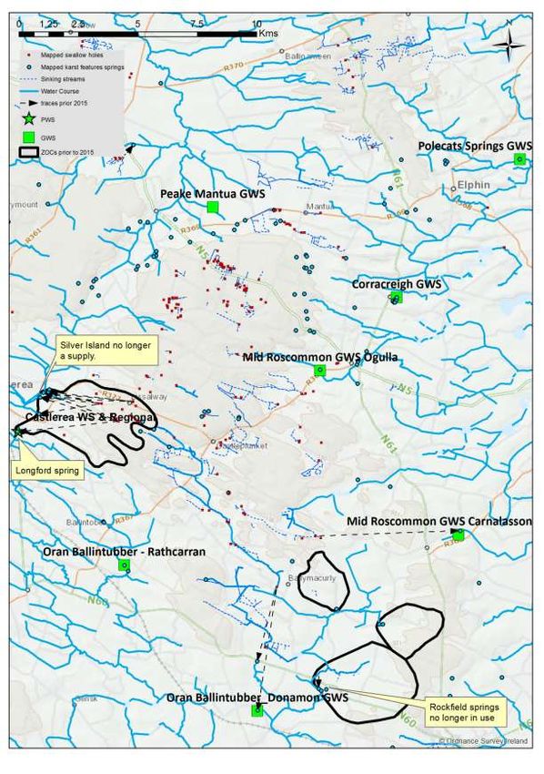
Cover page: A view across the Rathcroghan Uplands landscape at Kilree, near Tulsk, where
the dry landscape is dissected by a deep channel, iris-covered at base. The ridges on the
horizon are those at Bellanagare, underlain by sandstone bedrock, and the Plains of Boyle.

                    Contributors and Excursion Leaders.
Gerry Baker
Arup, 50 Ringsend Road, Grand Canal Dock, Dublin 4.
Rebecca Bradford
Groundwater Flood Project, Groundwater Section, Geological Survey of Ireland,
Beggars Bush, Haddington Road, Dublin 4.
Shane Carey
Groundwater 3D Project, Groundwater Section, Geological Survey of Ireland,
Beggars Bush, Haddington Road, Dublin 4.
David Drew
Department of Geography, Trinity College, Dublin
Damien Doherty
Tobin Consulting Engineers, Block 10-4, Blanchardstown Corporate Park, Dublin 15,
and Groundwater 3D Project, Groundwater Section, Geological Survey of Ireland,
Beggars Bush, Haddington Road, Dublin 4.
Natalie Duncan
Groundwater 3D Project, Groundwater Section, Geological Survey of Ireland,
Beggars Bush, Haddington Road, Dublin 4.
Noel Farrell
Chairman, Mid-Roscommon Group Water Scheme, Lismurtagh, Tulks, County
Roscommon.
Joe Gallagher
National Federation of Group Water Schemes, 12 Henry Street, Tullamore, County
Offaly.
Coran Kelly
Tobin Consulting Engineers, Block 10-4, Blanchardstown Corporate Park, Dublin 15,
and Groundwater 3D Project, Groundwater Section, Geological Survey of Ireland,
Beggars Bush, Haddington Road, Dublin 4.
James McAteer
Groundwater Flood Project, Groundwater Section, Geological Survey of Ireland,
Beggars Bush, Haddington Road, Dublin 4.
Ted McCormack
Groundwater Flood Project, Groundwater Section, Geological Survey of Ireland,
Beggars Bush, Haddington Road, Dublin 4.
Owen Naughton
Trinity Collge Dublin< Department of Environmental Engineering, and Groundwater
Flood Project, Groundwater Section, Geological Survey of Ireland, Beggars Bush,
Haddington Road, Dublin 4.
Markus Pracht
Bedrock Section, Geological Survey of Ireland, Beggars Bush, Haddington Road,
Dublin 4.
Programme
Saturday 13th October
10.00 Ballinderry
The National Federation of Group Water Schemes, Mid-Roscommon Group
Water Scheme, delineating Zones of Contribution (ZOCs) in karst, overview of
study and excursion area, moving from ZOCs to SPZs (Source Protection
Zones)
Joe Gallagher, Noel Farrell, Coran Kelly
11.00 Ogulla
The setting at Ogulla Spring, water quality issues, pressures, patterns of
contamination, investigative work carried out, Source Protection Plans
Joe Gallagher, Noel Farrell, Coran Kelly
12.00 Carrowreagh
Swallow holes and dolines, the issue of surface water sinking underground,
tracer testing and what it shows, general groundwater quality in karst,
potential measures
Coran Kelly, Natalie Duncan, Damien Doherty
13.30 Lunch in The Rathcroghan Centre, Tulsk
14.40 Oweynagat
Caves in Roscommon, cave hydrogeology
David Drew
16.00 GSI’s Roscommon Core Store
The succession in borehole GSI-16-002,Castlemine, County Roscommon
Markus Pracht
Sunday 14th October
09.10 Correal Turlough
Groundwater Flooding, the GW Flood Programme, Monitoring, Mapping and
Modelling, drainage and turloughs
Ted McCormack, Owen Naughton, Rebecca Bradford, James McAteer
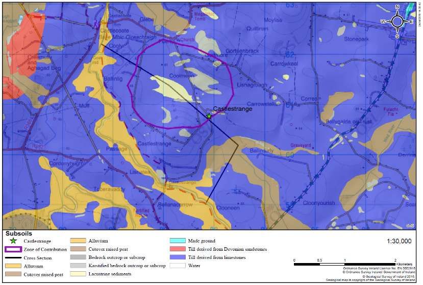
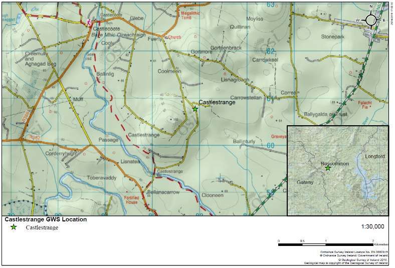
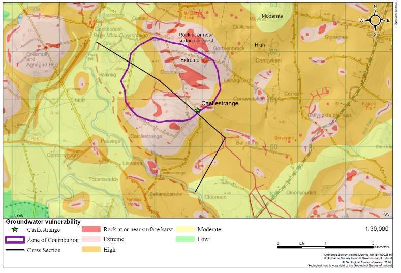
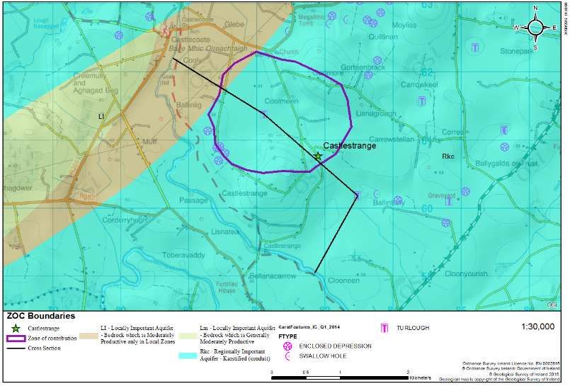
10.00 Castlestrange Group Water Scheme
Delineating a ZOC for a weirdly karstic locality, wellhead protection
Gerry Baker
11.00 Castleplunkett Turlough
How Castleplunkett floods, future work here, LIDAR.
Ted McCormack, Owen Naughton, Rebecca Bradford, James McAteer, Shane
Carey
14.00 Lough Funshinagh
Monitoring results on a weirdly karstic lake, how the lake floods, local issues.
Ted McCormack, Owen Naughton, Rebecca Bradford, James McAteer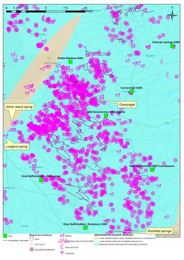
Location Map

Map showing field trip stops and other selected localities mentioned in this guide.
Preface
Just as with our field trip last year, on our annual field excursion this year we enter
another sacred landscape – that of Rathcroghan and the area surrounding it, in
County Roscommon. There exists an abundance of archaeological sites within this
region, with many of these sites having distinct relationships with the local soils and
subsoils geology, geomorphology, and hydrogelogy. In a broader sense, the wider
County Roscommon has a geologically diverse landscape with many places
treasured by both natives and visitors.
For early humans in Ireland, the landscape presented high escarpments, wide
plains, belts of hummocky terrain, extensive bogs and deep river valleys, all of which
played important and different roles in everyday life. This provided a challenging, but
more often than not accommodating, territory in which to settle.
Where water was found in the landscape was of paramount importance. Much of the
upland areas of Roscommon are effectively bone dry, with shallow, permeable soils
and subsoils allowing ready infiltration to deep groundwater. Thus, springs, as we
will see on our excursion, have long been an important focus as a water source.
This continues today, with almost all of County Roscommon’s drinking water supply
coming from groundwater. In a ritual sense, hydrological and hydrogeological
features have attracted interest, wonder, folklore and stories for centuries. So also
they do today, as we hear of the most recent investigations into a particularly hidden,
but particularly amazing, hydrogeological framework beneath Roscommon county.
As we examine turloughs this Sunday, we will learn that they are much changed over
time. From this, consider how important these features would have been as a food
source historically. Today, frogs and newts may spawn in turloughs and sticklebacks
may survive in larger turlough features, retreating into underground cracks in the
rock when waters are low. Shrimp and water-lice survive similarly. Where these
larger fish are absent water-fleas and fairy-shrimp are found in abundance. During
winter turloughs always attract flocks of geese, whooper swans, wigeon, teal, and
waders such as plovers, lapwings and sandpipers.
Following the last Ice Age, and for almost two thousand years, much of the lowlying
areas of the Irish landscape were inundated with water and many of the turloughs
were at that time permanent lakes. Therefore it is quite plausible that they had a
wider variety and more continued presence of freshwater fish and water birds at that
time and for many hundreds of years after this (i.e. possibly up until 7,000 years
ago). Turloughs such as those we will visit at Castleplunkett would therefore have
been an important, concentrated source of food for prehistoric settlers in this part of
Ireland.
We must always consider that what we see today in the natural landscape may have
changed in many ways since we humans arrived. The investigations we will see,
examine, scrutinise and discuss show us only some of the picture. Where we have
difficulty interpreting, we must always be able to think outside the box. This is what
makes hydrogeology such a holistic, fascinating and mind-boggling discipline.
This fact should frame much of our discussion over the next couple of days. I, and
all on the IAH Committee, hope you enjoy the trip.
Robbie Meehan
IAH Field Trip Secretary,
11th October 2018
Acknowledgements
This field guide would not have been possible without significant efforts from many
people, to whom the IAH are most appreciative.

All contributors produced excellent write-ups of sites, and thanks are due to all for
giving us their time in preparation and delivery of the excursion.

We would like to thank all landowners for giving us permission to visit their lands,
and it should be borne in mind that any future visits should only ensure when
permission has been sought.

Thanks also to McCaffrey coaches, and to Noel the bus driver, for getting us around
safely, and to all of the IAH Committee for help and advice.
1. An introduction to the geology of Roscommon
Robert Meehan
Although the geology of Roscommon is absolutely dominated by 330 million years
old limestones from the Carboniferous Period, there are much older rocks extending
back to nearer 500 million years ago, within the county. In Slieve Bawn, the Curlew
Mountains north of Boyle and northwest of Ballaghderreen there are much older
rocks exposed at the surface in small windows through the limestones. These
include two inliers (older rocks entirely surrounded by younger rocks) north-east of
Strokestown and at Slieve Bawn. These rocks are of Ordovician age and are the
remnants of a former ocean floor and the roots of a long since vanished mountain
chain. They are related to rocks throughout Longford, Down, and into the Southern
Uplands of Scotland, but as they occupy such a small area in Roscommon, their
story is best told in detail elsewhere.

Surrounding them are some Devonian age rocks, sandstones and gravels laid down
by flash floods in a poorly vegetated environment. Both Ordovician rocks and
Devonian rocks are partly preserved because they have been lifted up on the east
side of a fault, and are now preserved as the more resistant hills known as Slieve
Bawn. In the Curlew Mountains north of Boyle and westward through Sligo to
Ballaghderreen is a faulted block of the Devonian rocks, uplifted in relation to the
limestones either side of the block. The Devonian rocks are mostly sandstones and
pebble conglomerates, but include some volcaniclastic rocks; rock material erupted
by volcanos but then carried and deposited as sedimentary rocks like the
sandstones. The Boyle Road Cutting is a good place to see these rocks.

The Carboniferous limestones are dominantly well bedded, horizontal layers of a
remarkably uniform nature. They were originally deposited in a shallow marine
environment when Ireland was largely submerged under a warm tropical sea, and
the presence of fossils such as corals reflects this. The uniform nature of these beds
both across wide areas and vertically in thickness makes it difficult to map different
geological formations, and they are often simply considered as ‘shelf’ limestones,
from an open, shallow sea. These limestone rocks are present below the surface of
the largest part of Roscommon, but are actually rarely exposed. The veneer of
glacial sediments hides them, so the few rock quarries such as Keeloges,
Castlemine and Largan are important examples of what the subsurface is actually
like.

Only in the north of the county around Lough Allen are there younger solid rocks,
recording a time when the shallow sea was filled with deltas and swamps. In these
sandstone and shale rocks there are coal seams formed from ancient forests. The
land surface then emerged for nearly 300 million years and many of these rocks
eroded down to their present level. Only small parts of the country now remain
covered by these coalfield rocks, primarily the Castlecomer plateau in Kilkenny, the
Arigna district in Leitrim and the northern tip of Roscommon. Two County Geological
Sites in Roscommon are representatives of this geology. The Arigna Mining
Experience is a superb place to fully appreciate the underground geology of coal
deposits and the mining heritage of the district. Altagowlan, which is Roscommon’s
portion of a wider upland area along the Sligo county boundary, exemplifies the
place of coal in the energy supply of human society, now visibly met by windfarm
turbines scattered through the old coal mine features.
The most significant force to shape the form of the county as we see it today was the
Ice Age which ended about 10,000 years ago. Large ice sheets covered the county
for thousands of years and eroded the rocks beneath. As the ice eventually melted
away, the meltwaters reorganised the sediments into iconic landforms like eskers,
adjacent to large fans and deltas of sand and gravel, such as at the Cloonagh and
Errit Lough Deltas in the northwest of the county. The fans and deltas now stand out
as high ground with good grass amongst the boggier lake margins. Eskers were
formed by sub-glacial rivers, that is, they flowed in tunnels at the base of the ice
sheets. Some eskers are small and local within Roscommon, but others form
extended networks and cross several counties. The Ballinasloe–Split Hills-
Clonmacnoise-Clara Esker System is the most extensive of them, but the
Garranlahan Esker is also large and complex. The Castlesampson Esker is smaller
but equally valuable as an untouched example of the landform.

Some Ice Age features define the landscape character of large areas yet are so
large they can almost only be seen when using satellite or air photo images. West of
Boyle for example is a very fine discrete field of drumlins. These whaleback,
elongated ridges of glacial till were left by the ice sheets which covered the county.
On the ground they form low relief, breaking up any long vistas, but from above or on
a map with shaded relief they clearly show the sweeping passage of ice movements.
Even larger ribbed moraines, on a kilometre scale, are present across mid
Roscommon, but these need a trained eye to discriminate them from remotely
sensed images.

Since the Ice Age, the exposed limestone has developed into what is termed
karstified bedrock. Water solution of the rock formed some caves, widespread
collapse features and enclosed depressions called dolines. Where some larger,
temporary lakes were formed when meltwater was prolific, unusual mushroom
shaped stones were created by dissolution of the rock that was submerged.
Carrowmurragh and Moyvannan Mushroom Stones near the shores of Lough Ree
demonstrate it previously once had a far greater extent. Roscommon also has a
wealth of seasonal lakes called turloughs, where glacially scoured basins fill with
groundwater in the winter and dry out in summer as the water table lowers. Good
geological examples of these include Brierfield, Correal, Loughnaneane, Mullygollan
and Castleplunkett Turloughs. A special kind of turlough exists at Lough Funshinagh
which is a disappearing lake. Rather than seasonal fluctuations it occasionally drains
entirely as if someone had pulled the plug in the bath. A kind of pseudo karst
landscape has been identified around Killeglan west of Athlone. This is a unique site
with limestone boulder ridges formed as glacial deposits. Large parts are untouched
and represent a pristine landscape of Roscommon before human intervention and
land clearance and enclosures.

Geological processes continue to modify the landscape today, such as with seasonal
flooding of the Shannon and Suck River Callows. Slow build-up of alluvial sediments
and meandering of the river course can change a landscape scene in human
lifespans. Collapses of limestone into cavities beneath are more sudden events and
occur in some areas, but such holes are often quickly filled in by farmers and
landowners. The most active but unseen geological process going on is the
movement of groundwater. Since Roscommon has one of the highest percentages of
water supply from groundwater, such as from Rockingham Spring, immense care is
needed not to pollute the supply from badly maintained septic tanks or farm
practices, as limestone areas are very vulnerable to such destruction of a valuable
geological resource. Another geological resource, apart from limestone, coal and
groundwater, which was formerly exploited, is the clay deposit at Lecarrow. The
Knockcroghery clay pipe industry once supplied pipes for smoking tobacco to all of
Ireland from this ancient clay preserved in a karstic doline.
                                                                                              IF THIS
  AGE
              ERA           PERIOD               EVENTS IN ROSCOMMON                      TIMESCALE WAS
(Million
                                                                                                 A
 Years
                                                                                            DAY LONG ...
 Ago)
                         Quaternary      Several ice ages smothering Roscommon,           The ice ages would
   2       Cenozoic                      followed in the last 10,000 years by the          begin 38 seconds
                                         spread of vegetation, growth of bogs and          before midnight
                                         arrival of humans. Deposition of ribbed
                                         moraines drumlins and eskers.
                                         Dissolution of limestone beneath Quaternary
                                         sediments.
                         Tertiary        Erosion, especially of limestone.       Caves,
                                                                                          The Tertiary period
  65                                     cavities and underground streams developing
                                                                                          begins at 11.40 pm
                                         in mid-Roscommon. Potential deposition of
                                         clay at Lecarrow, near Lough Ree.
  145                    Cretaceous      Erosion.
           Mezozoic                      No record of rocks of this age in Roscommon.         11.15 pm
                         Jurassic        Uplift and erosion.                                The age of the
  205                                    No record of rocks of this age in Roscommon.     dinosaurs, starting
                                                                                             at 10.55 pm
  250                    Triassic        Desert conditions on land.                           10.42 pm
                         Permian         No record of rocks of this age in Roscommon.
  290                                                                                          10.30 pm
           Palaeozoic
                         Carboniferous   Land became submerged, limestones with                 Much of
                                         some shales and sandstones deposited in            Roscommon’s
  355                                    tropical seas across much of Roscommon.             current rocks
                                         Limestones remaining today are pure and              (limestone,
                                         unbedded in the majority, with smaller areas       sandstone and
                                         of muddier limestones at the edges.               shale) deposited
                                         Shales and sandstones with coal seams             around 10.10 pm
                                         deposited in Arigna district.
                         Devonian        Caledonian mountain building.                    ‘Old Red’ Sandstone
  410                                    Sandstones deposited in the Curlews and              deposited at
                                         north of Ballaghderreen.                               9.52 pm
                         Silurian        Shallow seas, following closure of the Iapetus
  444                                    Ocean. Greywacke and shales deposited at          Starts at 9.42 pm
                                         Bohalas in the northwest of the county.
  488                    Ordovician      Shales, slates, siltstones and volcanic rocks
                                         form across the Slieve Bawn ridge.                Begins at 9.28 pm
  542                    Cambrian        Opening of the Iapetus Ocean.                     Starts at 9.11 pm
                                         No record of rocks of this age in Roscommon.
 2500      Proterozoic   Precambrian     Some of Irelands oldest rocks deposited in
                                                                                          Beginning 11.00 am
                                         Mayo and Sligo.
 4000                                    Oldest known rocks on Earth.                      Beginning 3.00 am
           Archaean                      Age of the Earth.                                Beginning 1 second
 4600
                                                                                            after midnight
Figure 1. A simplified geology map of Roscommon outlining the main geological
units.
2. Group Water Schemes.
Joe Gallagher
What is a Group Water Scheme?
A group water scheme is defined as two or more house connections sharing a
common source or supply.

There are 2 types of group water scheme:

      Private: Local group abstracts and treats water from their own source eg well,
      lake and river. The group must ensure that the water is fit for human
      consumption. Under EU Regulations, the GWS will be legally responsible for
      water being supplied to its members.
      Part Private: Irish Water supplies treated water through the group’s pipes.
      Members are affected by Irish Water charges.

The Group Water Scheme, in both instances is responsible for their distribution
network, any maintenance including repair of leaks, scouring of lines and
replacement of equipment to a standard to ensure minimum leakage or wastage.
Treated water is an expensive commodity so it is important to carry out regular
maintenance to ensure minimum leakage or wastage.

The National Federation of Group Water Schemes
The National Federation of Group Water Schemes (NFGWS) is
the representative and negotiating organisation for community-owned rural water
services in Ireland.

From the outset, the objective of the NFGWS has been to secure equality of
treatment, ensuring that those it represents receive their full entitlement with regard
to the financial supports already conceded to their fellow citizens in urban areas.

The primary ‘external’ role of the National Federation of Group Water Schemes
(NFGWS) is to assist schemes in meeting the challenges of water quality legislation.

Formation of the NFGWS
Following the announcement of the abolition of service charges in respect of
domestic water supplies on public water schemes operated by local authorities
around the country in 1996, the private group scheme sector, serving in the region of
150,000 homes and rural businesses was excluded from the announcement and
required representation. In 1997 the National Federation of Group Water Schemes
was established following a series of meeting of Group Water Schemes, and was
quickly recognised as the representative organisation for private and part-private
group water schemes in Ireland. The Federation was incorporated as a co-operative
society in 1998.

The Work of the Federation Today
     Securing funding for a range of activities and measures such as the following:
     Achieving water quality through the installation of water treatment facilities
     and Source Protection.
Maintaining water quality through the implementation of a Quality Assurance
Scheme, which provides a guarantee that treated water is delivered safely to
members’ taps.
Water Conservation through metering of all connections and creating district
metered areas.
Meeting the numerous challenges of compliance and regulations through
recruitment and training at both operational and management level.
GWSs viability into the future through rationalisation and amalgamations.
3. Mid-Roscommon Group Water Scheme.
Noel Farrell
Mid-Roscommon Co-Operative Society Limited is a large private Group Water
Scheme that was formed on June 12th 2007. It is the amalgamation of 10 smaller
private group water schemes- Ardkennagh Tulsk GWS, Carnalasson Caggle GWS,
Carrowcrin GWS, Derphatten GWS, Hollywell Derrane GWS, Grange Fourmilehouse
GWS, Grage Lower GWS, Ogulla GWS, Rathmore Ballinderry and Shadlough GWS.
In 2010, we entered into a DBO (Design, Build, Operate) contract with Glan Agua
which entails the designing, building and operating the plant. This is in operation
since June 2011.
Mid-Roscommon has two spring sources at different locations- Ogulla, Tulsk and
Doorty, Fourmilehouse. The GWS has two reservoirs and treatment plants located at
Lismurtagh, Tulsk and Ballinderry, Fourmilehouse. The Scheme supplies water to
900 members with approximately 1,800 connections.
There are bulk meters and loggers located at different points on the GWS which
enable us to monitor the water usage in each area. All service pipe connections are
metered. Bulk meters are monitored on a daily basis, while water meters are read
four times a year, and people with high usage are notified.
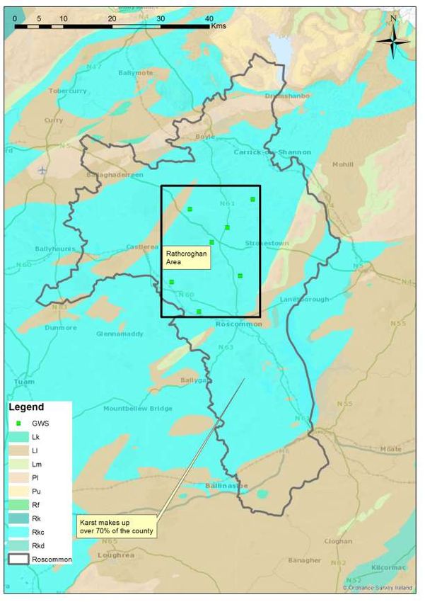
4. The Rathcroghan Area, County Roscommon.
Damien Doherty, Natalie Duncan, Coran Kelly, Robert Meehan, Sara
Raymond, Melissa Spillane
The majority of the bedrock of County Roscommon comprises undifferentiated pure
bedded Carboniferous limestones. These rocks are categorised as karstified
limestones, occupying approximately 1800 km2 of Roscommon’s 2500 km2 (Figure
2).
Due to the combination of a temperate climate and a relatively low-lying glacio-karst
terrain, there are numerous and ever-evolving groundwater-surface water
interactions, which are expressed on the surface as numerous swallow holes,
enclosed depressions, turloughs, large karst springs.
County Roscommon has been the subject of hydrogeological investigations and
studies over the last few decades. It was one of the first counties to have aFigure 2 County Roscommon, Rathcroghan Study area, Group Water Schemes associated with the study and the bedrock aquifer map
Groundwater Protection Scheme (Lee and Daly, 2002). One of the main reasons for
this is the reliance on groundwater for drinking water. In more recent times,
Geological Survey Ireland and the National Federation of Group Water Schemes set
about furthering the understanding groundwater characteristics for several supplies
sourced by springs in the Rathcroghan area. Whilst relatively small abstractions,
their respective catchments are disproportionately large which presents challenges
for source protection.      Additionally, this landscape presents challenges for
determining optimal flood relief options, land use management, catchment
management, water provision and treatment, conducting risk assessments, enforcing
regulation, and building roads.

                                                   Ogulla Spring 2018
                                          Can St. Patrick banish the nutrients?

Physical setting and hydrogeological characteristics
The Rathcroghan area is located in central Roscommon between Strokestown,
Castlerea, and Roscommon (Figure 2).          It is a karst limestone plateau of
                       2
approximately 200 km and 40-150 m above sea level. The plateau generally
receives 800 mm of rainfall per year and is characterised by ephemeral sinking
streams, enclosed depressions (dolines), swallow holes, caves1, turloughs2, a
general absence of permanent surface water courses, and relatively large springs
dotted around its perimeter. Several of these springs supply drinking water to Public
and Group Water Schemes. Contamination of these springs is relatively common,
and severe pollution incidents have occurred.

The bedrock geology (Morris, et al., 1999) consists predominantly of undifferentiated
Visean, pure, bedded, karstified limestone with a relatively large number of mapped
karst features that are critical to the hydrological and hydrogeological regime (Figure
3). The main structural trend is southwest to northeast.

1
 Please see David Drew’s text in this guide on Oweynagat cave.
2
 Please see Ted McCormack’s text in this guide on Castleplunket Turlough, which is located in the
Rathcroghan area.
Figure 3 Bedrock aquifer, karst features and sinking streams.
Figure 4 Current groundwater vulnerability (GSI) (1:40,000) in the Rathcroghan area.
Deep, mineral, poorly drained, (‘wet’) soils are the dominant soils type across the
area. Many areas of cutover peat, pockets of lacustrine clay and alluvium are also
mapped. Glacial till (‘boulder clay’) deposits are the predominant subsoil type.
Bedrock is generally close to the surface across the plateau.

Groundwater vulnerability is generally mapped as ‘Extreme’ across the majority of
the area of the Rathcroghan Uplands, where bedrock is often close to surface and
karst features (swallow holes, enclosed depressions and sinking streams) are
present in abundance (Figures 3 and 4). In the northeast and the central portion of
the area, where drumlins occur and where ‘moderate’ permeability till is present; the
groundwater vulnerability is mapped as ‘High’. Generally off the plateau and on the
lower ground, ‘Low’ groundwater vulnerability is mapped due to the presence of
thicker, ‘low’ permeability subsoil.

Delineation of ZOCs and Conceptual model
In order to protect the quality of the supplies it is important to establish the surface
and subsurface catchment areas, or ‘Zones of Contribution’ (ZOC), within in which
rainfall and potential contaminants may enter groundwater and move towards the
source. These ZOCs provide an area in which to focus further investigation and
implement protective measures to manage the groundwater quality and sustainable
abstraction rates. Given the unpredictable nature of karst groundwater, particularly
the direction of groundwater flow, establishing ZOCs requires specific techniques,
significant resources, suitable antecedent weather conditions, and time.

Lee and Kelly (2003), Drew (2005), and Hickey (2008) provide important insights into
the groundwater behaviour in the uplands. These investigations, predominantly
tracer studies, established ZOCs to the water supply springs at Castlerea and
Rockfield (no longer in use) located on the western and southern perimeter of the
uplands (Figure 5). One of the working assumptions made in understanding
groundwater behaviour in the region is that the Rathcroghan Uplands are both a
topographic/surface water divide and a groundwater divide with groundwater flow
directions expected to broadly follow the topography (Hickey, 2008). Whilst this is
broadly true, the tracing by Drew (2005) in the Rockfield spring area, show
groundwater flow directions contrary to surface water flow, indicating complicated
interactions between surface water and groundwater. All these investigations
suggest that dye tracing is one of the most important tools available to determine
flow directions in such terrain.

Geological Survey Ireland in collaboration with the National Federation of Group
Water Schemes (NFGWS) prepared desk-based ZOCs for each of the Group Water
Schemes (GWSs) as part of a national programme (Kelly, et al., 2015; Meehan, et
al., 2015). Knowing the uncertainties on groundwater flow direction, multi-dye
tracing investigations were carried out in 2015 and 2016 on and around the
Rathcroghan Uplands in an attempt to establish geo-scientific ZOCs for all the water
supplies in the area (Duncan et al., 2015, 2016).

The tracing in 2015 and 2016 comprised dye inputs at 16 swallow holes and
sampling of some 90 sample points, including springs and surface water courses.
This work also included tracing done in conjunction with Geological Survey Ireland,
as part of an environmental study for a road realignment proposal for the N5. The
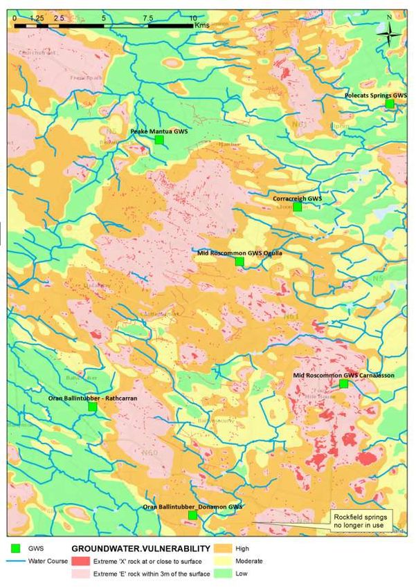
Figure 5 Rathcroghan Uplands, water courses, springs (including PWS – Public
Water Supply and GWS - Group Water Scheme Springs) and ZOCs delineated prior
to 2014.
Dye input October input - Breakthrough curves
Pollhesby and
Pollcatron
30 60
Cumulative rainfall (mm)
25 50
Dye Intensity (a.u.)
20 40
15 30
Polecats (FL)
10 20
Polecats (RH)
5
Cumulative rainfall (mm)
10
0 0
10/22/2016
10/27/2016
10/12/2016
10/13/2016
10/14/2016
10/15/2016
10/16/2016
10/17/2016
10/18/2016
10/19/2016
10/20/2016
10/21/2016
10/23/2016
10/24/2016
10/25/2016
10/26/2016
10/28/2016
10/29/2016
10/30/2016
10/31/2016
11/1/2016
11/2/2016
11/3/2016
11/4/2016
11/5/2016
11/6/2016
11/7/2016
11/8/2016
11/9/2016
11/10/2016
11/11/2016
Date
Figure 6 Breakthrough curve for Pollhesby and Pollcatron to Polecats.
Dye input
(Carrowreagh- July input - Breakthrough curves
Ballintubber)
160 80
17
140 BT1 70
Rhodamine Intensity (a.u.)
Cumulative rainfall (mm)
BT1 u/s
120 BT2 60
100 Cumulative rainfall (mm) 50
80 40
60 30
40 20
20 10
0 0
7/27/2016
7/20/2016
7/21/2016
7/22/2016
7/23/2016
7/24/2016
7/25/2016
7/26/2016
7/28/2016
7/29/2016
7/30/2016
7/31/2016
8/1/2016
8/2/2016
8/3/2016
8/4/2016
8/5/2016
8/6/2016
8/7/2016
8/8/2016
8/9/2016
8/10/2016
Date
Figure 7 Breakthrough curve for Carrowreach to Ballintubber.
resulting data, provided sufficient information on the overall groundwater flow
directions to the main springs to enable ZOCs to be delineated with some confidence
and the creation of site specific conceptual models.
The groundwater velocities were rapid with dye appearing in the springs within days,
including those that travelled significant distances, up to 10 km in some cases. The
typical average groundwater flow rate is 100 m/hour and selected breakthroughcurves are provided in Figure 6 and Figure 7. The results highlight an intricate network of flow with some unexpected directions, and provided evidence for delineating a ‘jigsaw puzzle’ of abutting ZOCs across the entire uplands. The results demonstrate that each of the springs is fed by groundwater originating in the uplands and also that each of the main springs is fed by a specific ZOC. The total area encompassed by the zones of contribution is approximately 200 km2. Figure 8 shows a conceptual model for the flow to Ogulla Spring. The difference between the original desk-based ZOCs and updated ZOCs is illustrated in Figure 8 and demonstrates the importance of detailed, karst specific, investigation in karst. Figure 8 Conceptual model to Ogulla Spring showing one of the traces Whilst the tracing has been successful in establishing robust ZOCs (based on the tracing and topography), uncertainties remain. Each boundary needs to be treated with caution, in particular, the boundaries to the south-western portion of the Polecats GWS ZOC which adjoins the Corracreigh ZOC; the overlapping area of the Corracreigh/Polecats ZOCs where dye injected at one swallow hole arrived at both springs; and the south-western portion of the Rathcarran ZOC. The traces also suggest that surface water and groundwater divides are not coincident in all cases, e.g., traces to Corracreigh, Rathcarran and Donamon. The area of the Rathcroghan upland west of Ogulla and Corracreigh springs ZOCs and northwest of Rathcarran ZOCs is assumed to feed water westwards, where there are several springs and water courses. One trace was attempted from this area but the tracer was not recovered at any of the sampling locations. A water balance calculation estimates the combined annual average outflow from the main supply springs, based on a range of low to high annual average recharge conditions and the area of the ZOCs, is estimated to be in the order of 1,300 to 4,400 l/s. A crude approximation of the combined mean flow from the main supply springs is approximately 4,000-5,000 l/s based on a few spot measurements. However, the measured overflow data are sparse. There are small springs within the zones of contribution which are active in wet weather that overflow to surface water courses
or sink back underground and there is no information on the water course flows. It is
assumed that the ZOCs are broadly correct and that the expected flow represents
the total flow out from the catchment even though there are surface water courses
exiting these catchments. Given the uncertainties there is a broad agreement in the
water balance.

Further hydrogeological investigations are required on the flows from the springs and
the sinks (to compare against the outflows), water quality information, additional
tracing, field scale karst feature mapping, including investigations into the depth to
bedrock in rock close areas.

On-going current work
The National Federation of Group Water Schemes and Geological Survey Ireland
are currently engaged in a pilot project which includes all of the Rathcroghan GWSs.
This work centres on communicating and working with the stakeholders in raising
awareness, defining areas where activities and pressures can be managed through
effective implementation of appropriate measures. The area encompassed by the
ZOCs is large and in terms of groundwater source protection presents a challenge to
the individual water supply schemes. This pilot is working to protect their schemes
as a whole, rather than individually.

Conclusions
Given the uncertainties in flow directions, establishing ZOCs in karst requires
specific techniques, significant resources, suitable antecedent weather conditions,
and time. As Figure 8 demonstrates, the confidence in the ZOCs is directly
proportional to the amount of resources invested. The dye tracing conducted in the
Rathcroghan Uplands has provided a great deal of information on the groundwater
characteristics, specifically groundwater flow directions and rates. The information
obtained enabled individual ZOCs to be defined for each of the water supply
schemes and highlights vulnerable areas within these catchments. There are areas
within the ZOCs that are riskier than others and thus there is a hierarchy that can
assist the schemes to tackle priority sites, i.e., swallow holes and sinking streams.

Selected References
Drew D. 2005 Rockfield Source Protection Zones. Unpublished report to Geological
Survey Ireland, Groundwater Section.

Duncan, N., Kelly, C., and Hickey, C. 2015, 2016. Reports on the Rathcroghan
Uplands Dye Tracing Programme 2015. Geological Survey Ireland. Unpublished
Report.

Hickey C. 2008, Landforms and Hydrology of the Lowland Karst of County
Roscommon, Ireland. Unpublished PhD Thesis, Trinity College Dublin.

Kelly C., Kabza M., Lee M., Hickey C., Hunter Williams T, Raymond S. and Salviani
N. 2015. Establishment of Groundwater Zones of Contribution. Polecats Scheme,
County Roscommon. Report for Geological Survey Ireland and the National
Federation of Group Water Schemes and Polecats Group Water Scheme.
Figure 9 Proven traces and desk-based protection zones prior to 2015 on the left and protection zones established in 2017 based
on subsequent tracing on the right.
Kelly C., Kabza M., Lee M., Hickey C., Hunter Williams T, Raymond S. and Salviani
N. 2015. Establishment of Groundwater Zones of Contribution. Corracreigh
(Cloonyquinn) Scheme, County Roscommon. Report for Geological Survey Ireland
and the National Federation of Group Water Schemes and Corracreigh Group Water
Scheme.

Kelly C., Kabza M., Lee M., Hickey C., Hunter Williams T, Raymond S. and Salviani
N. 2015. Establishment of Groundwater Zones of Contribution. Peak Mantua Group
Water Scheme, County Roscommon. Report for Geological Survey Ireland and the
National Federation of Group Water Schemes and Peak Mantua Group Water
Scheme.

Lee M. and Daly D. 2002 County Roscommon Groundwater Protection Scheme,
Main Report. Geological Survey Ireland & Roscommon County Council, Dublin.

Lee M. and Kelly C. 2003 Castlerea water supply scheme Longford spring and Silver
Island spring, groundwater source protection zones. Geological Survey Ireland and
Roscommon County Council.

Meehan R., Lee M., Hickey C., Hunter Williams T, Raymond S. and Salviani N.
2015. Establishment of Groundwater Zones of Contribution. Mid-Roscommon GWS,
County Roscommon. Report for Geological Survey Ireland and the National
Federation of Group Water Schemes and Mid-Roscommon Group Water Scheme.

Meehan R., Lee M., Hickey C., Hunter Williams T, Raymond S. and Salviani N.
2015. Establishment of Groundwater Zones of Contribution. Oran-Ballintuber GWS,
County Roscommon. Report for Geological Survey Ireland and the National
Federation of Group Water Schemes and Oran-Ballintubber Group Water Scheme.

5. Caves and karst hydrogeology in County Roscommon.
David Drew
Introduction
As is apparent from this field guide book (sections 1, 4 and 7 in particular), the
Carboniferous limestone in County Roscommon is highly karstified and in some
aspects it could be considered to be the most ‘typical’ area of lowland karst in
Ireland. However, diagnostic karst features, though ubiquitous (Hickey 2010 states
that in excess of 1,300 such features have been documented in the County) are
rarely spectacular.

Caves are commonly cited as being characteristic karstic landforms, and this is true
if the somewhat misleading term ‘cave’ is replaced by ‘conduit’ or ‘channel’. Caves
are simply conduits that are accessible to humans and they probably represent only
a small fraction of the channels available for transmitting groundwater. This may not
be the case in some upland areas such as the Burren but is certainly the case in the
lowland limestones that comprise the great majority of Ireland’s karst terrains.

Only seven features that could reasonably be described as caves are currently
known in County Roscommon, of which only one (Pollnagran), gives access to any
significant extent of underground passageways. In addition, only one of the known
caves (Pollnagran again) is hydrologically active; the remainder are relics of past
hydrogeological conditions in the area and are disconnected from the present day
groundwater circulation system.

It might be expected that streams flowing from elevated areas of non-limestone
strata would sink underground upon reaching the contact with the limestone –for
example the Slieve Bawn ridge in the east of the County and the Curlew Hills in the
west. However, this is not the case and the only stream sinks associated with this
geological contact are those in the Frenchpark area on the margins of the narrow
band of Boyle sandstone extending northeast from Castlereagh and rarely elevated
more than 15m above the surrounding limestone. However, all of the caves apart
from Pollnagran are located on low limestone plateaux of which Hickey (2010) has
identified eight in County Roscommon. Plan surveys of all seven known caves in the
county are given in Figure 1. Estersnow, Oweynagat and Ballynagoogh caves are
fragments of ancient phreatic caves wholly unrelated to the present topography and
having no flowing water. Pollnagollum at Frenchpark is a collapse doline, 5m deep,
which is intersected by a small vadose cave passage containing a stream. Lissany
cave is developed at the base of the epikarst in an area in which collapses are
common. In wet weather the cave contains a considerable stream which deposits
sand when it ceases to flow. This is the only cave of those described which is
probably of post-glacial origin and which relates to present day hydrogeological
conditions. Pollawaddy preserves fragments of a horizontal, phreatic network of
conduits invaded in part by a sinking stream. Finally, Pollnagran, at Frenchpark, with
750m of surveyed passage, is the only example of an active, vadose streamway
cave fed by a sinking stream. The water reappears from a spring only a short
distance from the surveyed end of the cave having passed beneath the N5 road at
shallow depth en-route. The location and character of this cave conduit suggests that
it developed under present day conditions (i.e. during the Holocene). However, the
cave has undergone a phase of infilling by fluvial sediment followed by the partial
removal of this material by the present stream. Also there is considerable collapse of
walls and roof and extensive deposits of calcite. It is difficult to believe that this
developmental history could all have occurred in post-glacial times so possibly the
development of the cave began during the last interglacial.

Oweynagat Cave (ITM 579538 783132) is located near the eastern margin of the
low limestone plateau that extends west as far as Castlereagh. The cave is
developed in undifferentiated Visean limestone, but immediately to the north is a
small outcrop of oolitic limestone. The dip of the strata is to the SSE at 2-5o. There
are no natural surface karstic features associated with the cave other than the
fissure to the northwest of the cave described below. The present day entrance is
via a souterrain at right angles to the main cave and the first 10m or so of the main
cave shows evidence of anthropogenic modification, with a roof comprised of lintel
stones. Due to its location in the Rathcroghan archaeological complex the cave has
been thoroughly explored and well documented, though much more from an
archaeological/folklore perspective (‘a gateway to the underworld’ etc.) than from a
karst-hydrogeological viewpoint.

Cave geomorphology
The cave proper consists of a single rift passage 47m long, oriented NNW-SSE
(Figure 10-G), the mirror image of the passage orientation of Pollnagran, the only
other cave with any significant length of explored passage in County Roscommon.
The rift is almost certainly more extensive, as the SSE end is blocked by collapse
rocks and clay and the NNW extremity by a clay fill. Geophysical data (Dempsey
2012) suggests that a clay filled rift extends to the NNW along the line of Oweynagat.
A hollow in the field to the north of Oweynagat is a designated archaeological site
but is probably also a collapse doline as it includes a short length of rift passage
oriented at 240 degrees (as is Oweynagat), which may well be the continuation of
the Oweynagat conduit.

The narrow, rift-like character of the cave and its proximity to the surface (1-2m)
suggests that it is simply a solutionally opened joint in the epikarst zone and
therefore of Holocene age. However, the cave is almost certainly more complex and
much older than this. Nowhere in the cave is a bedrock floor apparent and so the
passage must be greater than 7m in height and 2m in width. The cave has a partial
fill of sticky red/orange clay and boulders which in places, has been eroded away to
a depth of c. 5m. The origin of the boulders is uncertain but the clay seems to be a
typical cave fill deposit. Scallops (indicating past water flows) are large (10-20cm
diameter) and symmetrical suggesting slow rates of flow in the saturated zone. Thus
the cave was hydrologically active under very different conditions to those prevailing
today. Overall, the morphology of Oweynagat closely resembles that of many of the
inactive caves found in Counties Cork and Tipperary and the cave represents a
fragment of an ancient hydrogeological groundwater system in the Roscommon
lowland karst.

                                     A. Pollnagran
B. Ballynagoogh Cave C. Lissananny Cave D. Pollnagollum Frenchpark
E. Estersnow Cave

                              F. Pollawaddy

                          G. Pollnagat (Oweynagat)
Figure 10 A-G Plan surveys of caves in County Roscommon (Taken from Hickey
and Drew 2003).
Summary and conclusions The limited number of caves and of explored cave passages in County Roscommon give little reliable information concerning the character of the present day hydrological system in the Roscommon karsts. The majority of the caves refer to a sub-water table origin when the environment was very different. Perhaps Lissananny Cave might be most representative sample of present day conditions in the karst aquifer. There is also some evidence that large karst conduits do exist in the area. Hickey (2010), describes the results obtained by geophysical and drilling investigations in Mewlaghmore, east of Castlereagh, in and adjacent to lines of dolines (McGrath and Drew 2002). There appear to be conduits with dimensions of several metres located at a depth of c. 20m below ground level. The extent to which these conduits are sediment filled or otherwise hydrologically inactive is uncertain but they may represent major flow paths for karst groundwater prior to infilling by glacio-fluvial materials. References Dempsey G. 2012 Oweynagat. In: Roscommon and south Sligo, (eds B. Stefanini and G. McGlynn) IQUA Field Guide No. 30, 47-53, Irish Quaternary Association, Dublin. Fenwick J. and Parkes M. 2012 ‘Oweynagat’, Rathcroghan, Co. Roscommon. In: Roscommon and south Sligo, (eds B. Stefanini and G. McGlynn) IQUA Field Guide No. 30, 11-14, Irish Quaternary Association, Dublin. Hickey C. 2010 The Use of Multiple Techniques for Conceptualisation of Lowland Karst, a case study from County Roscommon, Ireland. Acta Carsologica 39-2, 331- 346, Special Edition: Research Frontiers and Practical Challenges in Karst Hydrogeology, Ljubljana. Hickey C. 2010 A conceptual model of the karst of Co. Roscommon. Geological Survey of Ireland Groundwater Newsletter, 48 15-19. Hickey C. 2012 Karst in the Castlerea area. In: Roscommon and south Sligo, (eds B. Stefanini and G. McGlynn) IQUA Field Guide No. 30, 60-72, Irish Quaternary Association, Dublin. Hickey C. and Drew, D.P. 2003 Caves of County Roscommon. Proceedings University of Bristol Spelæological Society 23-1, 35-50. McGrath, R., and Drew, D. 2002 Geophysics as a tool for karst groundwater mapping. Geological Survey of Ireland Groundwater Newsletter, 40, 12-14. 6. Upper Carboniferous (Mississippian) succession in borehole GSI-16-002,Castlemine, Co.Roscommon, Ireland Markus Pracht (based on reports to GSI by I..D.Somerville, UCD) Abstract In borehole GSI-16-002, from Castlemine just north of Roscommon Town, a nearly complete Mississippian (late Tournaisian to late Viséan) succession has been drilled
and cored (Asbian not present). Several carbonate formations have been
distinguished by microfacies analysis and their ages established by
micropalaentological investigations using foraminifera and calcareous algae.
Between 559 m and 893.2m (end of hole) a predominantly siliciclastic succession
has been drilled, which did not yield any useful micro-fossils for age dating.. The
lower part (819.6m to 893.2m) consists of tectonically deformed green, red and
beige sandstone, shales and micro-conglomerates topped by an unconformity.
Above the unconformity red and green shales, siltstones, sandstones and
conglomerates dominate between 819.6m and 619.6m, assigned to the Fearnaght
Formation. The Fearnaght Formation is overlain by 60.6m of Boyle Sandstone
Formation, a cyclic sequence of white massive bedded sandstone followed by dark
grey to black siltstone, topped by black mudstone/shale, The oldest marine
Mississippian (late Tournaisian) strata were drilled between 245.5m and 559m (a
thickness of 313.5m). They belong to the “North Midlands Province” . They comprise
the Meath Formation followed by the Moathill Formation, the Ballysteen Formation,
Waulsortian equivalent lithologies and the Kilbryan Limestone Formation. These
rocks reflect an increase in water depth during deposition which in turn is associated
with a marine transgression from the south.

The upper part of the cored succession consists of various types of Visean
limestones and can be directely correlated with the standard Visean succession of
Co. Galway and Leitrim . This succession is dominated by shallow-water limestone
(Oakport Limestone Formation, Ballymore Limestone Formation and Croghan
Limestone Formarion) that formed the Galway-Roscommon shelf.

Introduction and geological setting
The borehole was drilled as part of an ongoing mapping program to differentiate the
Visean carbonate succession (e.g. Pracht and Somerville 2015). The borehole is
situated in a tectonically defined block, bounded in the northwest by the Slieve Dart
inlier and in the south-east by the Strokestown inlier. Based on the thickness of
stratigraphic units (Kilbryan Limestone Formation, Oakport Limestone Formation and
Ballymore Limestone Formation) in borehole GSI-16-003, Bracknagh (11.5km to the
northwest of GSI-16-002), deposition in the northwest on this part of the
platform/ramp was thinner than in the south-east (Castlemine borehole).

The core is stored in the GSI corestore in Co. Roscommon. The borehole is located
in an active quarry (2016, see pic.1) ca.7km to the north of Roscommon Town and
worked by Roadstone (ITM: 87855/71006, ). The borehole collard in undifferentiated
Visean limestone and reach its target in “lower Palaeozoic” lithologies. The borehole
collard in the quarry floor (no overburden, Pic.2). It was terminated at 893.2m and is
as such the deepest hole drilled by GSI up to 2016. 53 samples for facies analysis
and age

determinations have been collected and processed by I.D.Somerville (UCD) and
M.Pracht (GSI) (MKP-16-102 to MKP-16-119, MKP-16-128 to MKP-16-148, MKP-16-
153 to MKP-16-165). The age determination is based on macrofauna (corals) and
microfossils (principally foraminifera and calcareous algae).The core is in excellent
condition and shows only minor fracturing in places.

Lithostratigraphy, biostratigraphy and microfacies
In the lower part of the borehole the stratigraphic units of the “North Midlands
Province” (Philcox 1984, Morris et al. 2003) are clearly recognisable (Fearnaght
Formation, Meath Formation and Moathill Formation) The upper part of the borehole
is represented by stratigraphic units of the Dunmore-Ballymoe succession of Pracht
and Somerville (2015). The Boyle Sandstone Formation (60.6m thick) has been
logged in borehole GSI-16-002, Castlemine, between the underlaying Fearnagh
Formation and the overlaying Stackallan Member of the Meath Formation.

The description of the various Lower Carboniferous (Mississippian) formations is
from oldest to youngest, beginning with with the basal siliciclastics and limestone
formations of Tournaisian age. This is followed by a description of younger Visean
limestone formation, which areally account for the majority of the Roscommon region
and is the main focus of this study. Biostratigraphic dating of the Tournaisian and
Viséan limestones has been achieved principally using foraminifers and algae,
supported by rugose corals. The assemblages have been assigned to the standard
Mississippian foraminiferal biozones MFZ6-MFZ14 of Poty et al. (2006; Table 1)
(broadly equivalent to the former Cf2 –Cf6ɣ zones and subzones, as used in Jones
and Somerville, 1996).
Lower Palaeozoic rocks (819.6-893.5m; >73.9m)
The contact between the base of the Lower Carboniferous Fearnaght Formation and
the Lower Palaeozoic (‘basement’) rocks is marked by an angular unconformity. The
Lower Palaeozoic rocks dip from 30-400 and are overlain by Fearnaght Formation
rocks which are gently dipping to horizontal. A tectonic fabric is recognised in the
basement rocks which is not developed in the overlying Carboniferous continental
red-bed clastic rocks. The Lower Palaeozoic rocks comprise grey and green
sandstones interbedded with shales and minor conglomerates. Reddening of the
Lower Palaeozoic rocks occurs for tens of metres below the unconformity (to c.
854m). Volcanic rocks are interbedded with the siliciclastic rocks of the Lower
Palaeozoic strata.

Microfacies: Ten samples of these rocks was examined in thin section (MKP-16-156
to -165). The majority comprise medium- to coarse grained, poorly-sorted immature
sandstones (feldspathic quartz arenites and feldspathic lithic quartz arenites) with
angular quartz, plagioclase feldspar, orthoclase feldspar, microcline, muscovite,
chalcedony and minor calcite cement.

Basal Carboniferous siliciclastic units (819.6m to 559m)
Fearnaght Formation (619.6-819.6m; 200m)
Above the unconformity an intraclastic breccia marks the base to the Fearnaght
Formation. The type section of the Fearnaght Formation in County Leitrim is no
longer exposed, but it is estimated that the formation can be up to 300 m thick in the
Strokestown area (Morris et al., 2003). The formation consists of red, green and grey
mudstone, siltstone and sandstone. Calcrete horizons, caliche, pisolithic beds,
dessication cracks and dewatering structures are common. Some of the sandstone
show cross bedding. In thin section the basal breccia consists of medium- to coarse-
grained poorly sorted breccias with lithic fragments. Mud and sandy matrix includes
detrital quartz, plagioclase feldspar, muscovite, iron oxides and chaclcedony. The
sandstones are medium-grained well-sorted feldspathic arenites with angular felspar
and quartz grains, occ. with calcareous matrix. Higher up in the Fearnaght
Formation septarian nodules appear. No age dates are available for this unit but a
lower Carboniferous age is inferred. The sediments were deposited in a continental
fluvial semi-arid environment (“alluvial fan”) with episodic flooding events.

Age: The Fearnaght Formation has been confirmed as Tournaisian age, based on
microfossil dating of the overlying limestones near Carrigallen (Morris et al., 1981).

Boyle Sandstone Formation (559-619.6m; 60.6m)
In the north of the region, the basal Tournaisian siliciclastic unit is identified as the
Boyle Sandstone Formation and has its type section near Boyle, Co. Roscommon
(Caldwell, 1959; Morris et al., 2003) where it is c. 100 m thick. It is also present in the
Slieve Dart and Castlerea inliers (Pracht & Somerville, 2015). The base is taken at
the top of the first green mudstone, siltstone and sandstone beds with rip-up clasts,
caliche units and dessication cracks. The upper contact of the Boyle Sandstone
Formation with the overlying Meath Formation at 559 m is sharp and defined by the
presence of the first marine limestone bed. In borehole GSI-16-002, Castlemine, the
Boyle Sandstone Formation consists of cyclic sequences of non-calcareous white
massive- to bedded (some bioturbated) sandstones (?= Drumbrick Sandstone
Member, see Philcox et al. 1992, re-logged and sampled by Pracht 2016and Lyne
2018) followed by dark grey to black siltstones, topped by black mudstone/shale ?=
Lough Key Mudstone Member,). The bedded sandstone/siltstones show current
ripples, linsen-bedding and flaser-bedding. Some burrowing also. No age dates are
available for this unit but a lower Carboniferous age is inferred.

Age: The Boyle Sandstone Formation has been confirmed as late Tournaisian based
on spore data (CM Zone) from the type section in Boyle (Morris et al., 2003). In GSI-
12-01 (Esker) borehole the Boyle Sandstone Formation ( > 30 m thick) is followed by
marine limestones of the Moathill Formation (Pracht & Somerville, 2015).

Meath Formation (413-559m; 146m)
This formation comprises an alternation of
grey and green calcareous sandstones,
red, green, dark grey and black siltstones
and mudstones, with thin argillaceous
bioclastic limestone intervals, and gypsum
nodules and bands (see picture right).
A massive pale grey fine-grained limestone unit with thin dark grey shales and
oncoids in the lower part of the Meath Formation (c. 518-540 m, approximately 22 m
thick) is considered to be the Stackallen Member (= “Micrite unit” of the Navan Mine
area, Philcox, 1984), as recognised in boreholes to the east of the River Shannon in
counties Meath and Westmeath (Morris et al., 2003). The thickness of the Meath
Formation (146 m) in Castlemine Borehole is very similar to that of the Strokestown
borehole (BB82-4) to the northeast, where Philox (1984) recorded 155 m, with a
lower micrite unit 55 m thick. Furthermore, as in the Castlemine borehole, red, pink
and green siltstones and mudstones (‘red bed facies’) are recorded together with
evaporites in the middle part of the Meath Formation in the Strokestown borehole
(Philox, 1984). The base of the Meath Formation at 559 m marks an important
boundary between siliciclastic-dominant units below and mixed siliciclastic and
carbonate units above. The upper boundary of the Meath Formation is placed at 413
m, below a 14-m-thick pale grey sandstone of the overlying Moathill Formation.

Microfacies: Seventeen samples of limestone and sandstone were examined in thin
section (MKP-16-131 to -147). The lowest sample (MKP-16-147) is a nodular silty
lime-mudstone conglomerate with brachiopods. Higher samples in the Stackallan
Member (MKP-16-144 to -146) comprise poorly-sorted, fine-grained silty skeletal-
peloidal lime mudstones and wackestones.The main skeletal components are
ostracods and rare foraminifers, with abundant detrital grains of silt-size angular
quartz, feldspar and muscovite. In the middle of the formation) dolomitised silty
bioclastic limestones contain crinoids, brachiopods and bryozoans. The brachiopods
show partial replacement by gypsum. One sample of sandstone (MKP-16-136) in
thin section is a well-sorted, fine-grained feldspathic arenite with angular grains of
quartz, feldspar and muscovite in a calcarous cement. In the upper part of the
formation coarse-grained poorly-sorted bioclastic limestones are present. In sample
MKP-16-132 (432.2m) sandy oolitic skeletal intraclastic grainstone/rudstone is
recorded with a rich and diverse biota of brachiopods, crinoids, bryozoans, ostracods
and gastropods. In MKP-16-131 (418.2m) near the top of the Meath Formation is a
coarse-grained shelly coquina dominated by bivalves, ostracods and oncoids with
cyanophyte tubes (Girvanella).

Depositional setting: The formation was deposited in a nearshore, shallow-water
siliciclastic-dominant shelf in which both fine- and coarse-grained clastic sediment
accumulated. Periodically, shelf limestones with a rich and diverse benthic biota
developed, when siliciclastic input onto the shelf was somewhat reduced. High-
energy conditions prevailed during the formation of the limestones, as suggested by
the transport and concentration of large shells and the presence of ooids. The lower
part of the formation (Stackallan Member) represents prolonged stable lagoonal
conditions associated with a major marine transgression in the area. The presence
of evaporites in the succession infer arid supratidal sabkha conditions developed
landward of the lagoons, as also indicated by the interbedded red-bed clastic rocks.
Periods of influx of coarser-grained siliciclasics interbedded with limestones
highlight the mixed character of the Meath Formation. The higher limestone beds in
the Meath Formation mark more turbulent higher energy conditions with open-marine
stenohaline fauna (large brachiopods, crinoids and bryozoans).

Age: Few age diagnostic microfossils were recorded in the Castlemine borehole. A
sparse foraminiferal assemblage including Endothyra, Earlandia, Tournayella,
Eoforschia and algal/cyanobacteria and microproblematica (Girvanella, Salebra
sibirica) suggest a mid Tournaisian age (MFZ6).

Moathill Formation (363.9-413m; 49.1m)
This formation comprises an alternation of argillaceous bioclastic limestone, grey
calcareous sandstone and dark grey and black mudstone. A tripartite division can be
made: a lower sandstone unit (c. 14m thick =”Upper Sandstone” of Philcox, 1984,
which is well developed in the Strokestown Boreholle (BB.82.4); a middle unit, 15m
thick, comprising alternating sandstones, mudstones and thin limestones; and an
upper siliciclastic unit, 20 m thick, with thick cross-bedded sandstones, mudstone
and rare silty limestones. The formation is much thicker than in GSI-12-01 (Esker) to
You can also read