Nuchatlaht First Nation Community Wildfire Protection Plan
←
→
Page content transcription
If your browser does not render page correctly, please read the page content below
Nuchatlaht First Nation
   Community Wildfire Protection Plan

                              Submitted to:
       Helena Michael – Acting Band Manager, Nuchatlaht First Nation
Shaun Koopman – Emergency Program Coordinator, Strathcona Regional District

                              Submitted by:
                          SuavAir Aerial Imaging
                            info@suavair.com
                              250-830-8849

                              June 26, 2020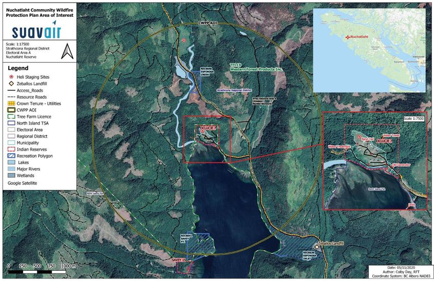
ACKNOWLEDGMENTS
This plan was prepared by Colin Filliter, RPF and Cynthia Lu, RPF of SuavAir Aerial Imaging
Inc. Colby Day, RFT completed the spatial data analysis and mapping. The authors would like
to thank and acknowledge the following people for their assistance and participation in
preparing the Nuchatlaht Community Wildfire Protection Plan:
Helena Michael – Acting Band Manager, Nuchatlaht First Nation
Anabel Jarry – Lands and Resources Department, Nuchatlaht First Nation
Shaun Koopman – Emergency Program Coordinator, Strathcona Regional District
Scott Boyd – GIS Analyst, Western Forest Products Inc.
Ben Boghean, Todd Flanagan, Raphael Jamin – North Island Fire Zone, BC Wildfire Service

This report was made possible by the support of the Union of BC Municipalities through the
Community Resiliency Investment grant.

REGISTERED PROFESSIONAL SIGN & SEAL

 Colin Filliter, RPF #                          Cynthia Lu, RPF #4923
 SuavAir Aerial Imaging                         SuavAir Aerial Imaging

 Date Signed: June 25, 2020                     Date Signed: June 25, 2020

Community Wildfire Protection Plan
Nuchatlaht First Nation                                                                      1
EXECUTIVE SUMMARY
The Nuchatlaht First Nation Community Wildfire Protection Plan (CWPP) was completed under
the framework established by the Community Resilience Investment program, administered by
the Union of BC Municipalities. The area of interest is the wildland urban interface (WUI)
surrounding the Nuchatlaht First Nation community at Oclucje, at the head of Esperanza Inlet on
the west coast of Vancouver Island. Oclucje is a remote community accessed by boat or by Fair
Harbour Forest Service Road west of the Village of Zeballos. The purpose of this CWPP is to
identify the wildfire risks surrounding the community, potential consequences of a wildfire to the
community, and to recommend possible ways to reduce the risk.
The fuel types in the area are predominantly a mixture of mature conifer forests and recently
harvested cutblocks. Previous fire history in the area indicates a low number of ignitions from
both human and lightning causes. The local wildfire threat classification is Moderate to High.
The local wildfire risk classification ranges from Low to High, with higher risk areas associated
with fuels in close proximity (within 500m) of the community.
The community’s remote location, limited communication networks, and distance from other
resources creates unique challenges. The recommendations in this report are summarized in
the table below. The recommendations are based on a review of best practices from other
jurisdictions, gaps identified through community engagement, the local wildfire risk analysis,
prevention of human-caused ignitions, and integration of FireSmart program principles.
FireSmart is a national initiative to educate and empower the public on what can be done to
protect their families, properties, and communities from wildfire. In March 2020, Local FireSmart
Representatives completed a Community Hazard Assessment report for Oclucje.
Fuel management activities (surface and ladder fuel removal) should focus on the first 100
meters of forested areas near the community. FireSmart practices should start with the first 10
meters around each structure in the community. Additional fuel management treatment areas
are recommended on provincial crown land within TFL 19 and along road/transmission line
rights-of-way. In addition to fuel management, community awareness and education play a
critical role in reducing the wildfire risk. Community awareness focuses on FireSmart principles,
understanding fire use restrictions, emergency preparedness, and regularly sharing fire safety
related information.
The BC Wildfire Service provides wildfire response services on the provincial Crown land
surrounding the community. Oclucje is not served by a local fire department. Due to the small
number of full-time residents, the capacity for local fire response is limited. Recommendations in
this plan aim to improve the community’s emergency and evacuation preparedness.
This plan makes 29 recommendations to the Nuchatlaht First Nation and Strathcona Regional
District. The recommendations should be further prioritized by the community depending on
local strengths, opportunities, and the availability of human, financial, and physical resources. At
minimum, the plan should be revisited every five years to assess the progress and relevance of
previous recommendations and for the continual improvement of wildfire protection planning as
more information becomes available.

Community Wildfire Protection Plan
Nuchatlaht First Nation                                                                             2
SUMMARY OF CWPP RECOMMENDATIONS
 No. Priority Objective                      Recommendation / Next Steps           Responsibility

  1.   High        To develop a              Complete a comprehensive              NFN with
                   comprehensive             Community Emergency                   support from
                   Community                 Preparedness and Response             FNESS
                   Emergency Response        Plan. Ensure the response plan
                   Plan.                     considers the effects of wildfire
                                             emergencies and addresses the
                                             potential impacts of WUI fires,
                                             poor air quality, evacuation plans,
                                             extended power outages, and
                                             road access concerns.

 Rationale: Best practice recommendation based on gaps identified during CWPP
 engagement. Emergency planning and evacuation planning are critical for community safety.

  2.   High        To improve dialogue       Meet with the forest tenure holder    NFN, with
                   between the Village       (Western Forest Products Inc.) to     support from
                   and forest tenure         understand post-harvesting fuel       BCWS North
                   holders regarding         risk and risk mitigation strategies   Island Fire
                   plans and strategies      within the WUI.                       Zone.
                   for addressing fire
                                             Emphasize the importance of fuel      Inter-agency
                   hazard risk and
                                             hazard management in cut blocks       cooperation is
                   abatement within the
                                             within the WUI (2km around the        a shared
                   WUI.
                                             community). If there are specific     responsibility
                                             concerns with fuel hazard in a        with industrial
                                             particular cutblock within the WUI,   operators.
                                             contact the BCWS North Island
                                             Fire Zone.

 Rationale: CWPP engagement with NFN noted limited communications between WFP and
 NFN on industrial activities surrounding Oclucje. Inter-agency cooperation and
 communication is one of the FireSmart disciplines.

  3.   High        To improve emergency      Implement a regular system for        NFN
                   preparedness and          tracking the numbers of elders,
                   evacuation planning for   children, and others who may
                   the community during      need assistance in the event of an
                   wildfire emergencies.     emergency evacuation.

 Rationale: Based on CWPP engagement with NFN and discussion on previous emergencies
 and voluntary evacuations. A process is recommended because travel/access resources may
 be periodically limited, or external support may need to be called upon in extreme cases.

  4.   High        To mitigate the impact    In addition to the procurement of     NFN with
                   of prolonged or           portable diesel generators            support from
                   extensive power           (currently in progress), review the
                                             feasibility of other more

Community Wildfire Protection Plan
Nuchatlaht First Nation                                                                              3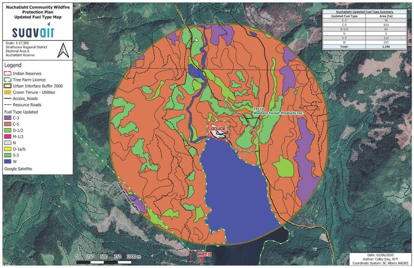
outages during             permanent secondary power             FNESS or
                   emergency events.          sources (i.e.: generators, solar      SRD
                                              panels, etc.).

 Rationale: Based on expressed concerns regarding reliable backup power and power outage
 restoration during CWPP engagement.

  5.   High        To reduce the fuel         Work with a qualified forest          NFN, SRD,
                   hazard in identified       professional to develop and           MFLNRO with
                   treatment areas (high      implement site specific               FNESS and
                   risk areas within 500m     assessments and fuel treatment        forest tenure
                   of the community, or       prescriptions for the                 holder support.
                   along FSR right-of-        recommended Treatment Areas.
                                                                                    Interagency
                   way).
                                                                                    cooperation
                                                                                    required.
 Rationale: Recommended treatment areas based on local wildfire risk analysis. High risk
 areas within 500m of the community or critical infrastructure are a priority for treatment.
  6.   High        To engage in the           Implement the FireSmart Activities    NFN, (possibly
                   FireSmart program; to      recommended in Table 7 of this        Operations
                   reduce the fuel hazard     report.                               and
                   and ignition risk within                                         Maintenance)
                   identified FireSmart
                   priority areas.

 Rationale: The FireSmart program is a nationwide initiative. Several post-wildfire examples
 across the country show how FireSmart activities reduce the structure losses associated with
 WUI fires. FireSmart activities are a focus area for all CWPP’s developed under the UBCM
 CRI funding program. FireSmart is implemented through best practices in 7 disciplines:
 education, emergency planning, vegetation management, legislation, development,
 interagency cooperation, and cross-training.

  7.   Low         To reduce the ignition     If propane is used as a fuel source   NFN
                   risk of propane tanks      for new homes/structures, ensure
                   located near               that the tank is located more than
                   structures.                10m from the structure and is
                                              located on top of a non-
                                              combustible surface (i.e.: gravel
                                              bed or concrete pad), and
                                              oriented safely away from nearby
                                              structures.

 Rationale: Propane tanks are a hazardous fuel and according the FireSmart home
 development best practices, should be located at least 10m from structures.

  8.   High        To reduce the fuel         Dispose of (chip and haul away,       NFN
                   hazard from previously     and/or burn) vegetative material
                   brushed materials          that was previously cleared as
                   within the community.      part of the 2019 community
                                              brushing project. Ensure any

Community Wildfire Protection Plan
Nuchatlaht First Nation                                                                           4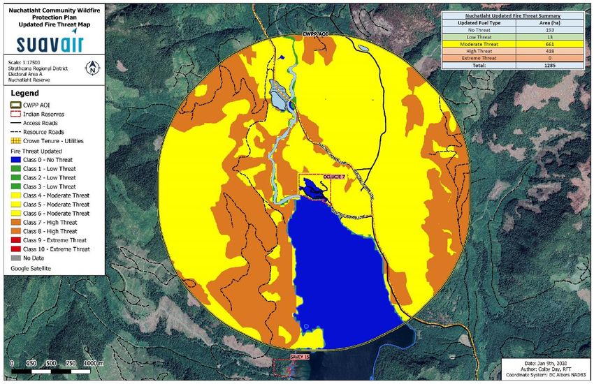
future materials from brushing or
                                               FireSmart activities have plan for
                                               removal.

 Rationale: Dead/down/dry surface fuels are a fire hazard. Fuel management requires the
 removal of surface and ladder fuels. Best practice for removal is to chip and haul away.

  9.   Med         To reduce the ignition      Ensure that roof replacements,         NFN;
                   risk of structures within   building restoration, or new           construction
                   the community by            construction considers the             contractors
                   following FireSmart         construction materials and
                   guidelines for              principles found in the FireSmart
                   construction materials.     Begins at Home – Home
                                               Development Guide.
                                               Any new construction occurring
                                               within the community should
                                               follow the FireSmart Home
                                               Development guide.

 Rationale: Best practice as per the FireSmart program, described in #6 above.

  10. High         To make this Plan and       Upload a digital copy of the           NFN and SRD
                   its associated maps         CWPP to the Nuchatlaht First
                   available to the            Nation and SRD Emergency
                   community.                  Planning websites.

 Rationale: Recommended best practice for community education and awareness regarding
 wildfire protection planning and FireSmart program implementation.

  11. Med          To improve community        Provide regular communications         NFN
                   awareness of wildfire       to community members (flyers,
                   risk and raising            notice boards, social media).
                   awareness of the            Recommend at least one fire
                   wildfire threat to the      related communication per month
                   community.                  (more often during fire season if
                                               required).
                                               Content of the communications
                                               include reminders on FireSmart
                                               practices, fire danger ratings, fire
                                               bans, fire prevention tips, air
                                               quality alerts etc.

 Rationale: Recommended best practice for community education and awareness regarding
 wildfire protection planning and FireSmart program implementation.

  12. High         To improve community        Organize an annual Community           NFN with
                   awareness of wildfire       Fire Safety day.                       FNESS or
                   risk and raising                                                   SRD support
                                               Activities may include checking
                   awareness of the
                                               fire extinguishers and smoke

Community Wildfire Protection Plan
Nuchatlaht First Nation                                                                              5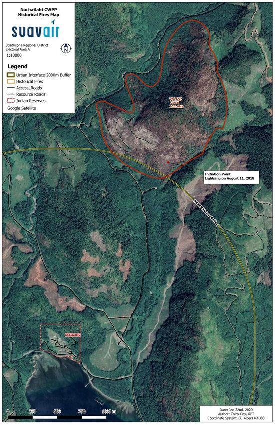
wildfire threat to the     alarms in homes, conducting
                   community.                 FireSmart clearing of Priority 1 (up
                                              to 10m) zones around homes, fire
                                              extinguisher practice, water
                                              suppression system (fire hydrants)
                                              practice, water pump practice.
                                              The Safety day could be timed
                                              with Fire Prevention Week which
                                              takes place annually during the 2nd
                                              week of October each year.
                                              October 4 to 10, 2020 is the next
                                              Fire Prevention Week.

 Rationale: Recommended best practice for community education and awareness regarding
 wildfire protection planning and FireSmart program implementation. Addresses education and
 emergency planning FireSmart disciplines.

  13. Med          To improve inter-          The SRD should arrange an              SRD
                   agency communication       annual regional meeting, prior to
                   regarding wildfire risk,   fire season, to include First
                   emergency                  Nations’ community
                   preparedness,              administration, BCWS – North
                   response, and              Island Fire Zone, EMBC, local fire
                   recovery.                  departments, and Village
                                              representative to review incident
                                              command structure,
                                              communication strategies and
                                              emergency support services in the
                                              event of a WUI fire.

 Rationale: Key contacts and individuals may change from year to year. Annual meetings
 recommended as a best practice to build relationships and improve communication in the
 event of a WUI event. Interagency cooperation and cross-training are FireSmart disciplines.

  14. High         To engage regional         Share this plan with regional          NFN and SRD
                   operators and              operators and stakeholders
                   industrial stakeholders    including MFLNRORD, forest
                   on the contents and        tenure holders (Western Forest         Regional
                   recommendations in         Products Inc.), and BC Hydro.          operators and
                   this plan.                 Areas of concern to highlight          stakeholders
                                              include the critical importance of     should review
                                              Fair Harbour FSR for access and        this plan.
                                              evacuation and minimizing the
                                              fuel hazards along its right-of-way;
                                              treatment areas in identified high
                                              risk areas on Crown/TFL lands;
                                              and minimizing fuel hazards along
                                              transmission line rights-of-way.

Community Wildfire Protection Plan
Nuchatlaht First Nation                                                                              6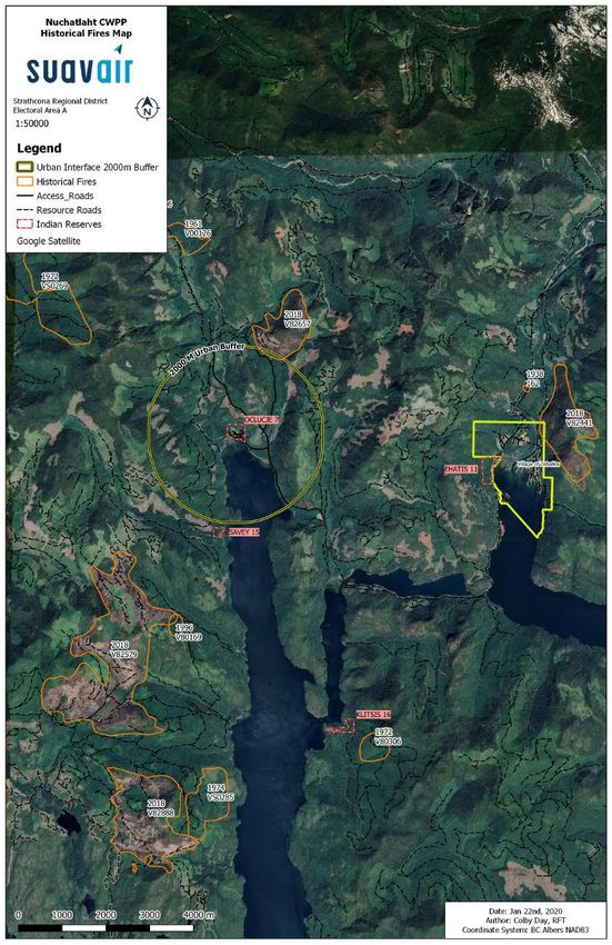
Rationale: Inter-agency cooperation within the WUI is necessary to protect a community and
 its critical infrastructure. Recommended best practice for information sharing, awareness,
 collaboration, and cooperation.

  15. Med          To ensure                Schedule annual check-ins             NFN, SRD and
                   implementation and       between Nuchatlaht First Nation,      FNESS
                   continual engagement     SRD, and FNESS to follow-up on
                   with CWPP.               recommendation implementation.
                                            Annual check-ins should also
                                            develop an annual action plan of
                                            priority items to be worked on for
                                            the year.

 Rationale: Recommended best practice to ensure follow-up on action items.

  16. Low          To increase awareness    Develop local regulation and          NFN
                   and to reduce the risk   policies for establishing
                   of human caused          community fire/fireworks bans
                   ignitions during         during high/extreme fire danger
                   high/extreme fire        class.
                   danger.

 Rationale: Recommended best practice to reduce the risk of human-caused ignitions during
 high fire danger.

  17. High         To improve community     Work with BCWS North Island           SRD, NFN
                   and public awareness     Fire Zone to install Wildfire
                   of wildfire prevention   Information signage at the junction
                   information.             of T’ashii-is Road and Fair
                                            Harbour FSR.
 Rationale: Based on CWPP engagement with NFN. Community interest in education and
 awareness; and increasing awareness of visitors/workers in the area that there is a
 community at Oclucje.

  18. Low          To improve the        Construct a storage building for a       NFN with
                   availability of fire  future fire truck and for emergency      support from
                   suppression equipment supplies.                                FNESS
                   and supplies.
                                         Ensure that materials used for           ISC Capital
                                         construction meet FireSmart              Facilities
                                         Development guidelines.                  Funding,
                                                                                  Infrastructure
                                                                                  Funding
                                                                                  programs

 Rationale: Based on CWPP engagement with NFN on possibility of a fire truck donation from
 the Village of Zeballos.
  19. Low          To improve community     If a pumper truck or other fire       NFN with
                   preparedness in          suppression equipment is              support from
                                            acquired, ensure community            FNESS

Community Wildfire Protection Plan
Nuchatlaht First Nation                                                                            7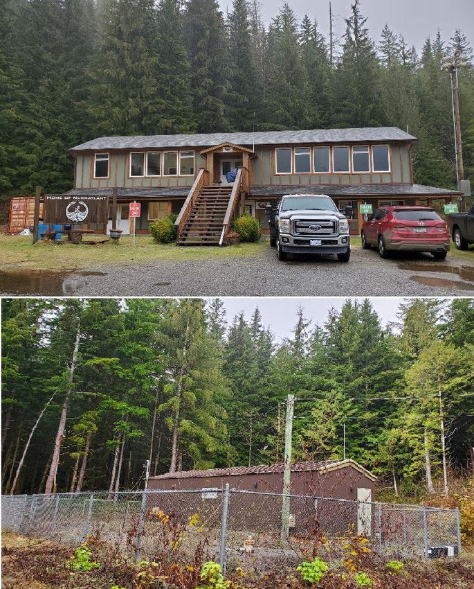
responding to a            members are adequately trained
                   structure fire.            in the operation and maintenance
                                              of the equipment.

 Rationale: As above.
  20. High         To improve the             Conduct an inventory of available     NFN
                   availability of fire       hand tools (shovels, pulaskis,
                   suppression equipment      axes, backpack water pump,
                   and supplies.              hydrant hoses, fittings/nozzles).
                                              Purchase hand tools and spare
                                              hoses for community use. Offer
                                              training to community members,
                                              ideally through the S100 course.

 Rationale: Best practice recommendation based on gaps identified during CWPP
 engagement. The current equipment inventory includes a water pump and hoses associated
 with hydrant toolboxes. Other hand tools or spare hoses/nozzles not known.

  21. High         To improve community       Establish written procedures with     NFN
                   preparedness for fire      roles and responsibilities for
                   response (i.e.: house      responding to structure and WUI
                   fires, back yard burns).   fire events in the community. Both
                                              documentation and operational
                                              practice of the procedures are
                                              recommended.

 Rationale: Best practice recommendation based on gaps identified during CWPP
 engagement.

  22. Med          To improve water           Hire a qualified professional to      NFN
                   availability for fire      assess water availability needs for
                   suppression.               fire suppression and community
                                              use.

 Rationale: Best practice recommendation based on gaps identified during CWPP
 engagement.

  23. High         To clear and maintain      Designate an area (within the         NFN
                   a helicopter landing       Emergency Plan) to be used as
                   area for emergency         helicopter landing area. Maintain
                   evacuations and/or         this area to be free of
                   wildfire response          obstructions, loose debris and
                   operations.                overhanging vegetation or
                                              obstacles. The best available
                                              option is the field.

 Rationale: Best practice recommendation for emergency access, BCWS access, and
 emergency evacuation, based on gaps identified during CWPP engagement.

Community Wildfire Protection Plan
Nuchatlaht First Nation                                                                   8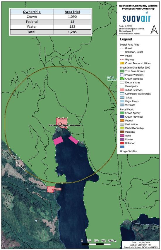
24. High         To improve emergency       Ensure each home has an               NFN
                   preparedness in the        emergency kit including supplies
                   event a wildfire or        for staying at home following an
                   other event disrupting     emergency, and grab-and-go
                   utility services and       bags containing the essentials in
                   road access.               case of an immediate evacuation.
                                              Purchase community emergency
                                              supplies in case wildfire cuts off
                                              road access to the community
                                              including generator and fuel,
                                              drinking water, and non-
                                              perishable food.
                                              A dry, sealed storage area is
                                              required to keep these items.

 Rationale: Best practice recommendation for emergency planning based on gaps identified
 during CWPP engagement.

  25. Med          To mitigate the impacts    Improve indoor air quality with the   NFN with
                   of heavy wildfire          purchase and use of High-             support from
                   smoke and poor air         Efficiency Portable Air (HEPA)        FNESS and
                   quality on the             filters, etc.                         FNHA
                   community.
                                              Purchase N95 respirator masks
                                              for distribution to community
                                              members during heavy smoke
                                              conditions to reduce smoke
                                              exposure.

 Rationale: Recommended equipment for improving indoor air quality during heavy smoke
 conditions, a concern identified during CWPP engagement.

  26. Med          To build capacity in the   Work with FNESS to develop an         NFN with
                   emergency                  emergency management program          support from
                   management area.           and training schedule that meets      FNESS
                                              the needs of the community.

 Rationale: Best practice recommendation based on gaps identified during CWPP
 engagement.

  27. Low          To build capacity in the   Work with FNESS to plan for           NFN with
                   emergency                  Foundational Training for             support from
                   management area.           governance staff, beginning with      FNESS
                                              Tier 1 and progressing to Tier 3
                                              over the next 5 years.
 Rationale: Best practice recommendation based on gaps identified during CWPP
 engagement.

Community Wildfire Protection Plan
Nuchatlaht First Nation                                                                            9
28. High To improve community Organize community training days NFN with
preparedness in using to practice using the available support from
available fire tools and community fire suppression FNESS
equipment if required system and other suppression
in an emergency. equipment.
Rationale: Best practice recommendation based on gaps identified during CWPP
engagement.
29. Med To increase the Purchase exterior sprinkler kits for NFN with
likelihood that homes homes; provide training to the support from
survive a WUI fire due community for how to set up the FNESS
to the distance of kits.
Oclucje to other
protective services.
Rationale: Based on current inventory, the equipment availability for structural protection
could be improved. Sprinkler kits are a relatively low-cost option and highly effective option.
Community Wildfire Protection Plan
Nuchatlaht First Nation 10Table 1. Summary of known resources and funding supports for recommended activities.
Resources Land Types of Projects
Jurisdiction
Forest Enhancement Provincial Crown Fuel management treatment prescriptions and
Society BC (FESBC) prescription implementation
UBCM Community Municipal FireSmart hazard assessments, demonstration
Resiliency Investment projects, off-site debris disposal (i.e.: chip
First Nations
Program (CRI) trucks)
Private
Community Education
Development planning
Emergency planning and cross training
UBCM Community n/a Emergency support services training
Emergency
Fire department training or equipment
Preparedness Fund
(CEPF) Emergency evacuation planning
Emergency operations training
First Nations First Nations Fuel management prescriptions and treatments
Emergency Support Reserve lands On-Reserve
Services – Indigenous
Services Canada
(FNESS/ISC)
BC Wildfire Service Provincial Crown Fuel management treatments (in coordination
with local fire zone officer)
Public education and outreach
Community Wildfire Protection Plan
Nuchatlaht First Nation 11CONTENTS
Acknowledgments ...................................................................................................................... 1
Registered Professional Sign & Seal.......................................................................................... 1
Executive Summary ................................................................................................................... 2
Summary of CWPP Recommendations...................................................................................... 3
List of Tables .........................................................................................................................14
List of Figures ........................................................................................................................14
List of Maps ...........................................................................................................................15
List of Photos.........................................................................................................................15
List of Acronyms .......................................................................................................................16
SECTION 1: Introduction ..........................................................................................................17
1.1 Purpose ......................................................................................................................17
1.2 CWPP Planning Process ............................................................................................18
SECTION 2: Local Area Description .........................................................................................19
2.1 CWPP Area of Interest ................................................................................................19
2.2 Community Description ...............................................................................................19
2.3 Past Wildfires, Evacuations, and Impacts ...................................................................23
2.4 Current Community Engagement ................................................................................23
2.5 Linkages to Other Plans and Polices ..........................................................................23
2.5.1 Local Authority Emergency Plan ..........................................................................23
2.5.2 Affiliated CWPPs .................................................................................................23
2.5.3 First Nation Plans and Policies ............................................................................24
2.5.4 Higher Level Plans and Relevant Legislation .......................................................25
2.5.5 Ministry or Industry Plans .....................................................................................25
SECTION 3: VALUES AT RISK ................................................................................................27
3.1 Human Life and Safety ...............................................................................................27
3.2 Critical Infrastructure ...................................................................................................28
3.2.1 Electrical Power ...................................................................................................30
3.2.2 Communications, Pipelines and Community Buildings .........................................30
3.2.3 Water and Sewage Infrastructure.........................................................................30
3.3 High Environmental and Cultural Values .....................................................................31
3.3.1 Drinking Water Supply Area and Community Watersheds ...................................31
3.3.2 Cultural Values ....................................................................................................31
3.3.3 High Environmental Values ..................................................................................32
Community Wildfire Protection Plan
Nuchatlaht First Nation 123.4 Other Resource Values ...............................................................................................32
3.5 Hazardous Values.......................................................................................................32
SECTION 4: Wildfire Threat and Risk .......................................................................................34
4.1 Fire Regime, Fire Weather and Climate Change .............................................................34
4.1.1 Fire Regime and Fire Weather .............................................................................34
4.1.2 Climate Change ...................................................................................................37
4.2 Provincial Strategic Threat Analysis (PSTA) ...............................................................39
4.2.1 Fire History ..........................................................................................................39
4.3 Local Wildfire Threat Assessment ...............................................................................43
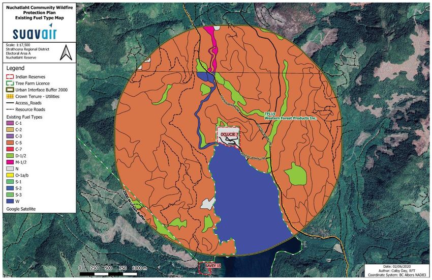
4.3.1 Fuel Type Assessment ........................................................................................43
4.3.2 Proximity of Fuel to the Community .....................................................................43
4.3.3 Fire Spread Patterns ............................................................................................43
4.3.4 Topography .........................................................................................................44
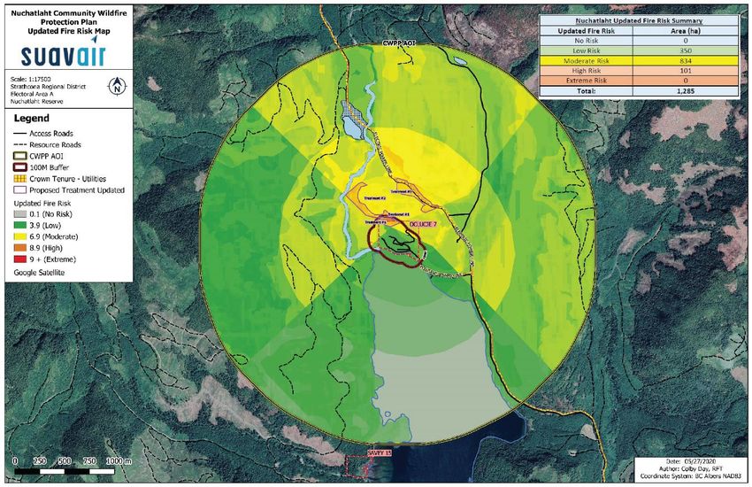
4.3.5 Local Wildfire Threat Classification ......................................................................45
4.3.6 Local Wildfire Risk Classification ...............................................................................45
SECTION 5: Risk Management and Mitigation Factors .............................................................48
5.1 Fuel Management .......................................................................................................48
5.1.1 Fuel Treatment Areas ..........................................................................................50
5.1.2 Funding Opportunities for Fuel Treatments ..........................................................52
5.2 FireSmart Planning & Activities ...................................................................................53
5.2.1 FireSmart Goals & Objectives ..............................................................................54
5.2.2 Key Aspects of FireSmart for First Nations’ Governments....................................55
5.2.3 Identify Priority Areas within the Area of Interest for FireSmart ............................57
5.3 Community Communication and Education ................................................................59
5.4 Other Prevention Measures ........................................................................................61
SECTION 6: Wildfire Response Resources ..............................................................................62
6.1 First Nation Firefighting Resources .............................................................................62
6.1.1 Fire Departments and Equipment ........................................................................62
6.1.2 Water Availability for Wildfire Suppression ...........................................................63
6.1.3 Access and Evacuation........................................................................................64
6.1.4 Training................................................................................................................68
6.2 Structure Protection ....................................................................................................69
Appendix 1: Local Wildfire Threat Process ................................................................................70
A1.1 Fuel Type Attribute Assessment ................................................................................70
A1.2 Proximity of Fuel to the Community ...........................................................................78
Community Wildfire Protection Plan
Nuchatlaht First Nation 13A1.3 Fire Spread Patterns ..................................................................................................79
A1.4 Topography ...............................................................................................................82
A1.5 Local Wildfire Threat Classification ............................................................................83
A1.6 Local Wildfire Risk Classification ...............................................................................84
A1.7 Summary of Fire Risk Classes ...................................................................................85
Appendix 2: FireSmart Practices and Activities .........................................................................87
Appendix 3: Wildfire and Emergency Response Training Courses ............................................89
Appendix 4: Community FireSmart Hazard Assessment Form ..................................................92
Appendix 5: Wildfire Threat Assessment – Fuel Type Change Rationale ..................................99
List of Tables
Table 1. Summary of known resources and funding supports for recommended activities. .......11
Table 2. Summary of land tenure classes and area within the AOI............................................21
Table 3. Summary and description of fire danger classes. ........................................................35
Table 4. Summary of local wildfire threat classification..............................................................45
Table 5. Summary of recommended fuel treatment areas. ........................................................50
Table 6. Summary of funding agencies providing grant money for fuel treatment projects. .......52
Table 7: Summary of recommended FireSmart priority areas. ..................................................57
Table 8. Description of fuel type layers. ....................................................................................71
Table 9: Fuel Type Categories and Crown Fire Spot Potential ..................................................73
Table 10. Summary of fuel type classes within the AOI. ............................................................75
Table 11: Proximity to the Interface ...........................................................................................78
Table 12: Slope Percentage and Fire Behaviour Implications ...................................................82
Table 13: Slope Position of Value and Fire Behaviour Implications ...........................................82
Table 14: PSTA Inputs Cross Walk Table – example ................................................................83
Table 15. PSTA Classification table - Low, Moderate, High, Extreme classifications taken from
2017 PSTA document. ..............................................................................................................83
Table 16. Weightings used in determining local wildfire risk. .....................................................85
Table 17: Local Wildfire Risk Weighting ....................................................................................85
List of Figures
Figure 1. Woss Camp weather station average monthly total danger class days 1970-2019.....36
Figure 2. Artlish weather station average monthly total fire danger class days 2007-2019. .......36
Figure 3: Cumulative seasonal precipitation and mean seasonal temperature projections for
2020s, 2050s, and 2080s. .........................................................................................................38
Community Wildfire Protection Plan
Nuchatlaht First Nation 14Figure 4. Understory thinning can reduce surface and ladder fuels. ..........................................49 Figure 5. The vertical arrangement of ladder fuels can carry a fire from the surface into the forest canopy. ...........................................................................................................................49 Figure 6. Wildland urban interface disaster sequence and where residents and landowners can break the disaster sequence. ....................................................................................................53 Figure 7. Why homes burn during WUI fire incidents.................................................................54 Figure 8. The FireSmart Structure Ignition Zone including the Priority Zones breakdown. .........55 Figure 9. TS Artlish Initial Spread Index rose. ...........................................................................80 Figure 10. Canadian Wind Atlas wind rose for the Oclucje area. ...............................................81 Figure 11: Local Wildfire Risk Inputs .........................................................................................84 List of Maps Map 1. Nuchatlaht First Nation CWPP area of interest. .............................................................20 Map 2. Nuchatlaht First Nation's Traditional Territory. ...............................................................21 Map 3. Land tenure classification within the AOI. ......................................................................22 Map 4. Historical fires recorded in the area. .............................................................................41 Map 5. 2018 lightning initiated Fire V82657 to the north of the AOI. .........................................42 Map 6. Updated local wildfire threat classification. ....................................................................46 Map 7. Updated local wildfire risk classification and treatment areas. .......................................47 Map 8. Recommended treatment areas and land ownership classes. .......................................51 Map 9. Evacuation via Fair Harbour FSR, Fair Harbour to the north and Village of Zeballos to the east .....................................................................................................................................66 Map 10. Existing 2019 PSTA fuel type layer. ............................................................................76 Map 11. Updated 2020 CWPP fuel type layer. ..........................................................................77 List of Photos Photo 1. Aerial image of critical infrastructure in Oclucje. .........................................................28 Photo 2. Nuchatlaht First Nation Office above, and water treatment plant below.......................29 Photo 3. On the left: the water reservoir (tower). On the right: one of four fire hydrant hose boxes. .......................................................................................................................................31 Photo 4. Propane tank serving as the back-up power source for the water treatment facility.....33 Photo 5. Aerial image of Oclucje with the 2018 wildfire V82657 in the distance. ......................40 Photo 6. Proposed Fuel Treatment Areas around Oclucje........................................................50 Photo 7. Fair Harbour FSR and the causeway bridge crossing Little Espinosa Inlet. ................65 Community Wildfire Protection Plan Nuchatlaht First Nation 15
LIST OF ACRONYMS
 Acronym          Full Name / Phrase

 AOI              Area of Interest

 BCWS             BC Wildfire Service

 CFFBPS           Canadian Forest Fire Behaviour Prediction System

 CRI              Community Resilience Initiative

 CWPP             Community Wildfire Protection Plan

 EMBC             Emergency Management BC

 FBP              Fire Behaviour Prediction System

 FNESS            First Nations’ Emergency Services Society

 FNHA             First Nations’ Health Authority

 FSR              Forest Service Road

 FWI              Fire Weather Index

 GIS              Geographical Information System

 ISI              Initial Spread Index

 LIDAR            Light Detection and Ranging

 LFR              Local FireSmart Representative

 MFLNRORD Ministry of Forests, Lands, Natural Resource Operations and Rural
          Development

 RESULTS          Reporting Silviculture Updates and Land Status Tracking System

 PSTA             Provincial Strategic Threat Analysis

 SRD              Strathcona Regional District

 TFL              Tree Farm Licence

 UBCM             Union of BC Municipalities

 WFP              Western Forest Products Inc.

 WUI              Wildland Urban Interface

Community Wildfire Protection Plan
Nuchatlaht First Nation                                                            16
SECTION 1: INTRODUCTION
Wildfire is an integral part of British Columbia’s ecosystems and landscapes, including areas
where citizens settle and communities grow. Due to an increasing population with expanding
rural development and the impacts of climate change, more communities in B.C. are in areas of
potentially increased wildfire risk. The Community Wildfire Protection Plan (CWPP) process
helps communities develop plans to improve safety, lower the risk of damage to property, and
reduce the impacts of wildfires to BC communities. This CWPP is organized into the following
major sections:
SECTION 1: Introduction - Explains the purpose of a CWPP and the planning process
SECTION 2: Local Area Description - Defines and describes the Area of Interest for the CWPP
SECTION 3: Values at Risk - Introduces the extent to which wildfire has the potential to impact
values at risk within the area of interest
SECTION 4: Wildfire Threat and Risk - Describes the process that was undertaken to identify
and summarize the fuel hazard and other factors that contribute to the wildfire threat and risk
SECTION 5: Risk Management and Mitigation Factors - Outlines the strategies that can be put
into practice to reduce the risk and the impact of a wildfire in four subsections
5.1 Fuel Management: identifies and prioritizes fuel management treatments
5.2 FireSmart Planning and Activities: summarizes the current level of FireSmart
implementation and identifies priority areas for future FireSmart activities
5.3 Community Communication and Education: describes the key steps required to build
engagement and support within the community for the CWPP. This includes education
and outreach and local community prevention programs.
5.4 Other Preventative Measures: identifies local actions and strategies that reduce the
threat of wildfires
SECTION 6: Wildfire Response Resources - provides a high-level overview of the resources
that are available to local governments in the case of a wildfire.
1.1 Purpose
The purpose of this CWPP is to identify the wildfire risks within and surrounding the Nuchatlaht
First Nation community at Oclucje reserve (referred to as Oclucje, hereafter). This CWPP
provides an updated assessment of the wildfire risk to the area and will examine the potential
consequences if a wildfire were to impact the community. The CWPP will discuss and explore
different methods to reduce wildfire risk. Sections within this document will cover the threat to
human life, property, and critical infrastructure from wildfires within the WUI, will identify
measures necessary to mitigate those threats and will outline an action plan to implement those
measures.
The CWPP is intended to provide a framework for implementation of actions that should result
in:
• reduced likelihood of wildfire entering the community
• reduced impacts and losses to human life, property, and critical infrastructure
• reduced negative economic and social impacts to the community
Community Wildfire Protection Plan
Nuchatlaht First Nation 171.2 CWPP Planning Process
The Community Resiliency Investment (CRI) Program is a provincial grant program from the
Union of BC Municipalities (UBCM). The CRI program helps fund costs associated with writing
CWPPs and is the main funding source for the development of this CWPP. Since the CRI
program was founded in 2018, over 120 First Nations and local governments have received
funding for CWPP development. 1 The Strathcona Regional District (SRD) obtained a CRI grant
to develop community wildfire protection plans for Electoral Area A including participating
communities of the Village of Sayward, Village of Gold River, Village of Tahsis, Village of
Zeballos, Nuchatlaht First Nation, Ka:'yu:'k't'h'/Che:k:tles7et'h First Nations; and for Read Island
within Electoral Area C. In Fall 2019, SuavAir Aerial Imaging Inc. was contracted by the SRD to
carry out the project in collaboration with municipal governments, First Nations, regional
stakeholders, provincial government agencies, and residents.
The CWPP planning process consists of the following phases:
1. Background research – general community characteristics, economic profiles,
demographics, community plans, emergency planning, critical infrastructure, fire history,
fire weather, property values, environmental values, cultural values, land jurisdiction, and
relevant legislation.
2. Consultation with local governments, First Nations, regional district, provincial agencies
– to identify values at risk, existing fire suppression capacity, and to understand current
community engagement with respect to wildfire risk mitigation
3. GIS Analyses – review Provincial Strategic Threat Analysis (PSTA) data, using the best
available information including LiDAR data, updated forest cover and ortho imagery to
adjust fuel typing errors, and modify threat and risk classification where necessary
4. Field Work – verification of critical infrastructure, fuel types, identification of community
specific values at risk
5. Draft report and mapping development – identification of measures to mitigate risks,
make recommendations for action
6. Report review – professional peer review, regional district, and community review
7. Community engagement and education – community presentations, follow-up
Understanding the relationship of the community to its surrounding environment, and what that
means in terms of the wildfire hazard, threat and risk of loss, is critical to help the community
plan for mitigation activities and respond to wildfire events. To support this understanding, the
BCWS has conducted a Provincial Strategic Threat Analysis (PSTA) for the identification of
wildfire threat and potential fire behaviour. The outputs of the PSTA were made available to
SuavAir for the study and analysis. Other relevant data was gathered through field visits to the
community, stakeholder engagement, proprietary LiDAR data shared for exclusive use on this
project by Western Forest Products Inc., and publicly accessible data from the BC government
Data Catalogue.
1
Union of BC Municipalities. Community Resiliency Investment.
(https://www.ubcm.ca/EN/main/funding/lgps/community-resiliency-investment.html)
Community Wildfire Protection Plan
Nuchatlaht First Nation 18SECTION 2: LOCAL AREA DESCRIPTION
2.1 CWPP Area of Interest
The area of interest (AOI) is defined as the Nuchatlaht First Nation community at Oclucje
Reserve IR 7 (Oclucje) and its surrounding wildland urban interface (WUI) polygon. The WUI is
a 2km buffer around areas with structure density greater than 6 to 25 structures per km2.
Oclucje Reserve is 13.3ha and the surrounding AOI is 1285ha. See Map 1 for a view of the
AOI.
2.2 Community Description
The Nuchatlaht First Nation is a member of the Nuu-chah-nulth Tribal Council, their traditional
territory is shown in Map 2. Nuchatlaht First Nation utilizes a Hereditary Chieftainship model; in
this model the Chief is appointed by their father or grandfather and then appoints their council. 2
Historically, the main community was at Nuchatl (located at Nuchatl IR1), off the west coast of
Nootka Island. In the 1980’s, community members moved from Nuchatl to Oclucje for improved
access to services.
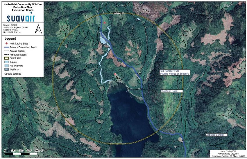
Oclucje is not within the fire protective services area of any local fire department. The closest
fire protection service is the Village of Zeballos’ volunteer fire department, about 14km or 30
minutes drive on the gravel Fair Harbour Forest Service Road (FSR). The community does not
have a service agreement with the Village of Zeballos due to distance and road conditions that
make access unfeasible for fire department trucks.
Access to Oclucje by T’ashii-is Road that junctions from Fair Harbour FSR. From this junction,
the Village of Zeballos is 14km to the east and the Fair Harbour Marina is 22km to the north.
Fair Harbour FSR and Zeballos FSR are primarily industrial roads but are also the only road
networks connecting communities of Ka:'yu:'k't'h'/Che:k:tles7et'h First Nations, Walter’s Island
(SRD Electoral Area A), Nuchatlaht First Nation, Ehattesaht Chinehkint First Nation, and the
Village of Zeballos with the rest of Vancouver Island via Highway 19. The Fair Harbour FSR is
under road permit to Western Forest Products Inc. from the Zeballos log sort to the Chum Main
junction. The remainder of the FSR to Fair Harbour is managed by the Campbell River Natural
Resource District. Road conditions vary depending on active industrial use and weather
conditions. The other access options are by air (helicopter) or water – via Espinosa Inlet.
2
Nuchatlaht First Nation. Governance History. http://www.nuchatlaht.com/strategic-plan.html
Community Wildfire Protection Plan
Nuchatlaht First Nation 19Map 1. Nuchatlaht First Nation CWPP area of interest. Community Wildfire Protection Plan Nuchatlaht First Nation 20
Map 2. Nuchatlaht First Nation's Traditional Territory. 3

Map 3 shows the land tenure classes within the AOI. The area surrounding Oclucje is Tree
Farm Licence (TFL) 19, held by Western Forest Products Inc. Table 2 summarizes the land
ownership classes found within the AOI.

Table 2. Summary of land tenure classes and area within the AOI.

        LAND OWNERSHIP                            AREA (HA)          COMMENTS
        Provincial crown land                     1090               WFP, Aa’tuu
        Federal – Indian Reserve                  13                 Nuchatlaht FN, Oclucje Reserve
        Water                                     182
        Total                                     1285

3
    Nuchatlaht First Nation. Our Territory. http://www.nuchatlaht.com/our-territory.html

Community Wildfire Protection Plan
Nuchatlaht First Nation                                                                               21
Map 3. Land tenure classification within the AOI. Community Wildfire Protection Plan Nuchatlaht First Nation 22
2.3     Past Wildfires, Evacuations, and Impacts
The Ministry of Forests, Lands, Natural Resource Operations and Rural Development
(MFLNRORD) and BC Wildfire Service (BCWS) manage a provincial database of historical fire
ignitions and fire perimeters. This data was reviewed as part of the planning process.
In August 2018, lightning strikes ignited dozens of wildfires across northern Vancouver Island.
Three of these wildfires burned within 10 km of Oclucje (Map 5). The closest fire was V82657
that ignited 2km to the north, burning away from the community in mountainous forested terrain.
The fire was monitored by the BCWS but not responded to immediately due prioritization of
resources during an exceptional fire season. Fire V82579 was located 3.5 to the south of
Oclucje, while the Gold Valley Main fire (V82441) was burning near Zeballos, 6.5km to the east.
Structures in Oclucje were not threatened by any of the 2018 fires, however, a voluntary
community evacuation took place due to the impacts of smoke and poor air quality. Other
impacts to the community included power outages and another wildfire (Pinder Creek, V92443)
occurring upslope of the Zeballos FSR which threatened the only road access connecting the
community to the rest of Vancouver Island. Most community members evacuated to stay with
family or in hotels in the Campbell River area, with only 2 residents staying behind in the
community. Community members were away from their homes for 7-10 days. The physical and
emotional toll of the 2018 wildfires, including smoke and evacuations, are significant and cannot
be understated.

2.4     Current Community Engagement
This CWPP is the first time Nuchatlaht First Nation has been engaged in wildfire prevention
measures and planning around Oclucje. There is no known history of fuel management
treatments, FireSmart activities, or other wildfire prevention measures in the area.

2.5     Linkages to Other Plans and Polices
The following sections are a summary of the NFN policies and provincial policies and guidelines
that relate to strategic wildfire management, wildfire threat reduction, operational fuel treatments
and emergency planning.

2.5.1 Local Authority Emergency Plan
The Nuchatlaht First Nation Administration is currently working with a contractor to update and
finalize a new Community Emergency and Evacuation Plan for 2020. The previous Community
Emergency Plan did not include detailed information regarding evacuation procedures or an
Evacuation Map. It is important to highlight the possible evacuation routes due to the remote
and rugged nature of the area. The evacuation plan should also indicate muster points and the
location of emergency supplies and provisions.

2.5.2 Affiliated CWPPs
Affiliated CWPPs include plans for the Village of Zeballos and SRD Electoral Area A, completed
concurrently with this plan.

Community Wildfire Protection Plan
Nuchatlaht First Nation                                                                          23
2.5.3 First Nation Plans and Policies
The following community plans are available online: Communications Plan (2017),
Comprehensive Community Plan (2015), Language Revitalization Plan (2017), 2018-2023
Strategic Plan, 5-year Economic Development Plan (2017), and the Tsunami Preparedness
Strategic Plan 2018-2020. 4 The tsunami preparedness strategic plan addressed the need for
improved egress routes and evacuation vehicles, emergency communications, and emergency
supplies for the community. Several recommendations where made in the Tsunami plan and the
implementation of these recommendations is still ongoing. In September 2019, NFN installed
and tested a tsunami siren and public announcement speaker system (controlled at the Band
Office).
Emergency preparedness plans are operational level plans that assist administrators in carrying
out their roles/responsibilities during and after an emergency. A comprehensive Community
Emergency Preparedness Plan should detail community information, emergency management
organization and roles, emergency social services, evacuation routes, and recovery
roles/procedures. It is outside the scope of the CWPP to address all elements of an emergency
preparedness plan. Some priority areas are highlighted in the CWPP recommendations.
The completion of a comprehensive community emergency response plan is an urgent priority
given the remoteness of the community. The plan should address alternative evacuation routes
should the sole access road (Fair Harbour FSR) be blocked or unsafe for use. It is
recommended that the evacuation plan include a regularly updated list of licenced automobile
and boat operators as well as the number and passenger capacity of vehicles and boats
available for use during an emergency evacuation. Where possible, look to coordinate aspects
of the emergency preparedness and response plan with the communities of
Ka:'yu:'k't'h'/Che:k:tles7et'h First Nations, Ehattesaht Chinehkint First Nation, and the Village of
Zeballos.

     No. Priority Objective                          Recommendation / Next Steps            Responsibility

      1.   High        To develop a                  Complete a comprehensive            NFN with
                       comprehensive                 Community Emergency                 support from
                       Community Emergency           Preparedness and Response           FNESS 5, 6
                       Response Plan.                Plan. Ensure the response plan
                                                     considers the effects of wildfire
                                                     emergencies and addresses the
                                                     potential impacts of WUI fires,
                                                     poor air quality, evacuation plans,
                                                     extended power outages, and
                                                     road access concerns.

4
    Nuchatlaht First Nation. Community Planning. http://www.nuchatlaht.com/our-plans.html
5
 FNESS BC. Emergency Management. Community Emergency Preparedness Plan Template.
https://www.fness.bc.ca/resources/library/emergency-management/community-emergency-preparedness-plan-
template
6
    FNESS BC. Emergency Management. https://www.fness.bc.ca/core-programs/emergency-management

Community Wildfire Protection Plan
Nuchatlaht First Nation                                                                                 24
2.5.4 Higher Level Plans and Relevant Legislation The AOI is within the Vancouver Island Land Use Plan Enhanced Forestry Zone 18 – Eliza. The Eliza Landscape Unit does not have an approved landscape unit plan or landscape unit level objectives. Provincial forestry legislation applicable to provincial Crown Land includes the Forest and Range Practices Act and its associated regulations and the Wildfire Act and its associated regulations. Other relevant legislation includes the Heritage Conservation Act, Land Act, and Environmental Management Act. Wildfire Act and Wildfire Regulation Under the Wildfire Act, the government may order open fire bans, create restricted areas, restrict certain activities, and recover fire control costs amongst other activities and actions laid out in the Act. The Wildfire Act pertains to all “forest land” and “grass land” and lands within 1km of “forest land” and “grass land” regardless of public or private ownership. The Wildfire Act and Wildfire Regulation require those carrying out industrial activities to conduct fire hazard assessments and to abate hazards that are identified. For industrial activities inside or within 2km of a fire protection district: fire hazard assessments are required to be conducted at 3-month intervals during which industrial activities are taking place (Wildfire Regulation, Section 11(2)(a)). For non-forest tenure holders conducting industrial activities; hazard abatement is required within 6 months of the hazard assessment (Wildfire Regulation, Section 12 (1)). Forest tenure holders are required to abate hazards within 24 months of the beginning date of the industrial activity (i.e.: forest harvesting) (Wildfire Regulation, Section 12.1(2)(a)). Oclucje is outside of a Fire Protection District. For industrial activities outside 2km of a fire protection district: fire hazard assessments are required to be conducted at 6-month intervals during the period of industrial activities (Wildfire Regulation Section 11(3). The required hazard abatement must occur within 30 months of the beginning date of the activity in the area. For utility transmission operations, the Wildfire Regulation Section 10, requires that utility transmission equipment operating on or within 300m of forest land or grass land must be maintained in a manner that reduces the likelihood of producing an ignition source, and the site maintained in a manner that prevents fire spreading from the site. 2.5.5 Ministry or Industry Plans Directly adjacent to the Oclucje Reserve is Western Forest Products Inc. Tree Farm Licence (TFL) 19. TFL 19 Management Plan #11 and the WFP Central Island Forest Operations 2017 Forest Stewardship Plan apply to TFL 19. Aat'uu Forestry Limited Partnership also operates within the AOI in the North Island Timber Supply Area. The AOI is within a Moderate polygon according to the BCWS Fuel Hazard Assessment and Abatement Fire Risk Map. 7 The risk class 7 BCWS Post Harvest Hazard Abatement Map. https://governmentofbc.maps.arcgis.com/apps/webappviewer/index.html?id=9bb5372c65464f0bab178907a5c39 947 Community Wildfire Protection Plan Nuchatlaht First Nation 25
You can also read