KARM EL- ZEITOUN URBAN SNAPSHOT - MARCH 2021 - ReliefWeb
←
→
Page content transcription
If your browser does not render page correctly, please read the page content below
KARM EL-
ZEITOUN
URBAN
SNAPSHOT
MARCH 2021

Developed by Beirut Urban Lab
In partnership with ACTED
Funded by UNHCR
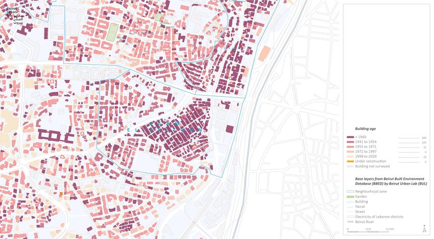
TABLE OF CONTENTS

  TABLE OF CONTENTS .......................................................................................................... 2
  INTRODUCTION ................................................................................................................... 3
  METHODOLOGY .................................................................................................................... 4
  I. THE NEIGHBORHOOD ....................................................................................................... 7
  II. STAKEHOLDERS IN THE NEIGHBORHOOD .................................................................... 21
  III. RECOVERY STATUS ...................................................................................................... 23
  IV. RECOMMENDATIONS OF SITES FOR POTENTIAL COMMUNITY-BASED PROJECTS .... 26
  V. ANNEX A ........................................................................................................................ 29

2 | KARM EL-ZEITOUN URBAN SNAPSHOT | Working document
INTRODUCTION
_______
On August 4th, 2020, the Port area of Beirut was rocked by two massive explosions, killing over
                                           1
200 people and wounding more than 6,000 . Buildings were destroyed or damaged within a 10 km
area around the port, including an estimated 70,000 apartments and nearly 40,000 residential or
commercial spaces.
UNHCR partnered with four international organizations (MEDAIR, ACTED, Save the Children, and
Intersos) to rehabilitate shelters, restore shared spaces, and introduce the upgrading of selected
neighborhood–level communal spaces, in six neighborhoods severely affected by the blast:
Karantina, Mar Mikhael, Geitawi, Badawi, Bachoura, and Karm el-Zeitoun. In this framework, ACTED
and Beirut Urban Lab at the Maroun Semaan Faculty of Engineering and Architecture (MSFEA) at
the American University of Beirut (AUB), partnered to develop an assessment meant to support the
effort of locating the recovery efforts within an urban-scale approach in each of the above-
mentioned neighborhoods.
This report is one of the six Urban Snapshots conceived by the Beirut Urban Lab (BUL) in
partnership with ACTED and funded by UNHCR in Fall/Winter 2020-2021.
The reports are designed to a) Inform the understanding of each of the four INGOs and UNHCR
about the urban processes underway in each of the neighborhood prior to the blast, focusing on
those processes that are likely to slow-down or threaten the return of residents and the recovery of
the neighborhood, and b) Whenever possible, point the INGOs in each of the neighborhood towards
potential communal projects of important social relevance.
Further, the Urban Snapshots have the potential to support the work of the community of social
workers, city planners, urban designers, researchers, activists, and others who are intervening with
relief, repair, and recovery in short, medium, or long term development in Beirut in response to the
August 4th, 2020 port blast.
The assessment built on the knowledge and research of the Beirut Urban Lab about each of the six-
neighborhood’s history and urban conditions. Additional fieldwork was conducted by a team of field
researchers to gather the needed information from neighborhood-level interviews and discussions
with residents, NGOs, etc.
Each of the reports locates the effects of the explosion within the larger urban trends that have
influenced the studied neighborhood over the past three decades. It does so by providing a
preliminary urban documentation and analysis of the neighborhood conditions, including a brief
historical overview, insights about contextual urban trends, profiles of influential stakeholders, and
a brief review of socio-spatial conditions. To the extent possible, the reports thus cover both urban
trends and recovery efforts at the household (e.g., resident, business-owner), building, and
neighborhood scales (e.g., shared space, road, recycling).
Each report further unravels some of the critical threats that are likely to undermine the recovery
of each neighborhood, including dwellers’ return, the rehabilitation of shared spaces and amenities,
the reignition of economic activities, and the restoration of tangible and intangible heritage.
The reports are not conceived as exhaustive surveys. Rather, they are snapshots, taken at a specific
moment (i.e. November-December 2020), yet located within a solid understanding of the economic,
social, and political forces that influence Beirut’s ongoing urbanization. Indeed, they build, as
outlined thoroughly in the methodological section, on pre-existing knowledge of the neighborhood
developed at the BUL and complemented by data gathered during November and December 2020
directly in the neighborhoods.

1
    Lebanon Reform, Recovery and Reconstruction Framework 3RF

3 | KARM EL-ZEITOUN URBAN SNAPSHOT | Working document
METHODOLOGY
_______
The selection of neighborhoods and the delineation of their boundaries were proposed by UNHCR,
reflecting its areas of intervention. In order to improve the coherence of the study and its
recommendations, the BUL research team introduced mild modifications in delineating
neighborhoods to account for the internal characteristics of the neighborhood, particularly lot
morphologies, building typologies, and population profiles. Neighborhood boundaries thus do not
coincide with official administrative boundaries.

The reports are the result of the work of six field researchers, one reporting officer and one
research team coordinator hired by ACTED who were trained by the Beirut Urban Lab (BUL) team
and worked under its supervision from October to December 2020. The positions were filled
through a transparent and competitive process putting the emphasis on previous experience and
methodological trainings; three of the six fieldworkers had worked for the Beirut Urban Lab before,
and another was a recent graduate of the Master in Urban Design program at AUB.

The production of this report relied on case-study research methods of data collection as defined by
    2
Yin. In essence, Yin sees the goal of case studies as understanding complex social phenomena,
relating data to propositions and aiming at analytical generalization as if they were an experiment.
By nature, case-study research is qualitative and typically uses multiple methods to collect different
kinds of evidence (e.g. documents and archival records; interviews; direct and participant
observation; physical artifacts; surveys), as this insures the triangulation and cross-checking of
evidence, and hence more rigorous and valid data analysis.

For this report, BUL relied on five data sources collected through: (i) desk reviews of available
publications, technical reports, records and other documents; (ii) field observations (direct and
participant) using the guide available as annex C; (iii) qualitative semi-structured interviews with key
informants (e.g. mukhtar(a), NGOs’ representatives) according to protocols described below and
available as annex D, as well as informal conversations with residents and business-owners; (iv)
data from the shelter technical assessment collected between September and December 2020 by
INGOs intervening in the area and provided by UNHCR in December 2020; (v) surveys and maps
compiled by the BUL’s researchers about Beirut’s built environment in the context of the Beirut
                                     3
Built Environment Database (BBED) .

(i) Documents and Records (Desk review)
                                                          4
Data analysis relies on the review of several gray reports , academic research, and references
available about the neighborhood. They are listed as footnotes throughout each report whenever
they were used as evidence for the documentation and analysis of some of the neighborhood’s
urban trends.

(ii) Field Observations
The researcher conducted fieldwork for about 12 full days in the neighborhood (1.5 day per week for
a duration of 8 weeks, on the average), observing directly the built environment, documenting
damaged constructions and processes of physical repair in residences and businesses, as well as
noting the following: shops’ activity/closure; buildings’ quality and condition; abandoned/dilapidated
buildings; clusters of impoverishment; construction activity; heritage buildings; the use of
open/public spaces by the community and presence of greenery; infrastructure conditions (access
to water and electricity, traffic congestion, conditions of streets, sidewalks and stairs); options for
waste disposal. The researcher also observed social interactions in the neighborhood, when they

2
    See Yin R.K, Case-Study Research: Design and Methods (2014) London: Sage.
3
  The Beirut Built Environment database is an online GIS platform developed by the Beirut Urban Lab at the
American University of Beirut. The initiative brings together a collection of maps, documents, and surveyed
indicators about actors as well as spatial and environmental characteristics that can inform ongoing research,
public policy making, and advocacy about the city. It also relies on a database of building permits dating back
to 1996.
4
 Gray literature is produced outside of the traditional commercial or academic publishing and distribution
channels and typically includes reports, working papers, government documents, white papers and evaluations.
Organizations that produce grey literature include government departments and agencies, civil society or non-
governmental organizations, academic centres and departments, and private companies and consultants.

4 | KARM EL-ZEITOUN URBAN SNAPSHOT | Working document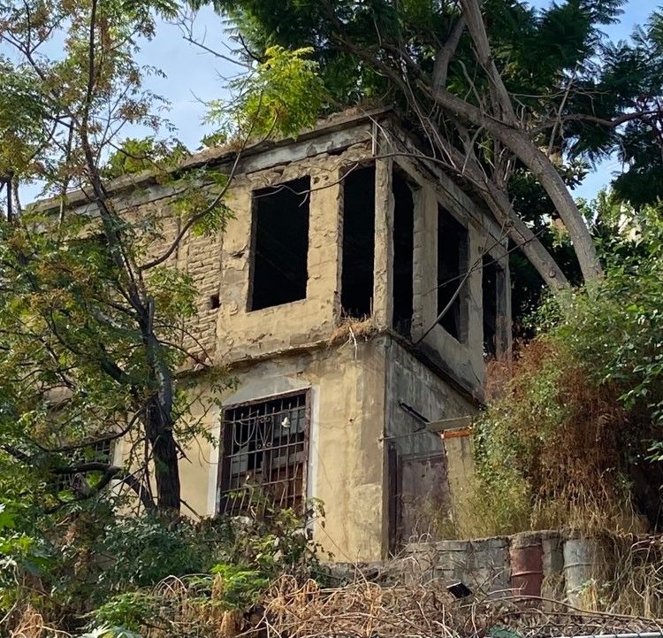
occurred and documented them, including groups of migrant workers and refugees. They were
tasked to also document key landmarks in the neighborhood (educational, religious, cultural,
corporate), and to report visible political sites and signs (flags, icons, posters, markings on walls).
These observations were recorded as field notes and mapped, when relevant, serving as evidence
that substantiates several claims made in this report, as indicated in the text.

(iii) Qualitative semi-structured Interviews and Conversations with key informants
Field researchers were trained to conduct semi-structured qualitative interviews with key actors in
the neighborhood they were able to reach out to amidst the difficult working conditions posed by
the COVID-19 pandemic. They interviewed neighborhood’s elected local representative (mukhtar(a)),
NGOs’ representatives, as well as dwellers and business-owners who stayed and are engaged in the
repair process. The interviews’ questions were organized in three broad categories: (a) Awareness
about the actors in charge of repair (do they know who is in charge, who visited them, who
returned, what support were they provided with thus far); (b) Respondent’s tenure status (do they
own or do they rent, do they pay in real or Lebanese dollars or in LBP, how precarious is their
tenure situation, do they get any support from family abroad, what are their future plans: are they
staying or leaving, and why?); (c) Processes of repair (did they receive support, for what, from who,
where is the process at, what is still to be done, are damaged common spaces fixed?). In addition,
researchers also conducted interviews and informal conversations with residents and business-
owners, on selected sections of the interview guide. Overall, 45 in-depth interviews were conducted
in Karm el-Zeitoun.

All interviews and conversations were conducted after securing verbal consent and according to
ethical standards of social research. Cited interviews and conversations have been anonymized and
personal identifiers removed to protect interlocutors.
Field observations and qualitative interviews were documented by field researchers through
pictures and detailed notes, geo-referencing the location wherever possible. They then reported the
interviews and developed fact sheets that were discussed with the rest of the team.
(iv) Quantitative Technical Assessment Data collected between September and December
2020 by INGOs operating in the area under UNHCR funding
Qualitative findings are complemented by an analysis of technical assessment data shared by
UNHCR, providing technical assessment of a prioritized number of damaged houses in the six
neighborhoods (according to criteria set by UNHCR), conducted in December 2020 by its INGO
implementing partners (one per neighborhood). BUL researchers analyzed this dataset and
extracted statistical information from it, which is referred to in the report. It should be noted that
the technical assessments were conducted in specific targeted areas of each neighbored as part of
the shelter response implementation, therefore not resorting to any type of probability sampling.
Furthermore, the data used as part of this research originates from UNHCR partners only, thereby
not taking into account any other technical assessment data that may potentially have been
collected by other actors in the area. As such, corresponding findings may not be extrapolated to
the entire neighborhood, but rather interpreted as a useful triangulation source for the findings
deriving from qualitative data sources. The total number of assessed housing units in the 6
neighborhoods amount to 5262, including 257 in Karm el-Zeitoun. It is worth noting that the
collected data includes a substantive number of “no entries” (reaching up to more than 90% for
some questions and averaging 40% for the others) which means the data needs to be interpreted
cautiously. Yet, the data is representative for several sets of assessment variables, and BUL used it
to support findings with substantiate qualitative findings. This is notably the case for nationality of
occupants; level of damage (level 1, 2 or 3); status of repair; mode of repair; type of assistance;
reason for lack of repair; mode of occupancy in each neighborhood (old/new rent, hosting,
ownership); and type of rental contract (written, oral). This set of evidence is mainly used in the
“Socio-Demographic Profile,” “Housing Conditions, and “Recovery Status” sections of the report.

(v) Spatial Data and Mapping
The report relies largely on spatial data compiled within the framework of the BUL’s Beirut Built
Environment Database (BBED), which has been made available thanks to the MoU agreed upon
between ACTED and BUL. This includes data regarding population size; density; damage
assessment; building age; building height; real-estate developers profiles; vacancy rates; number of
loans acquired from the Public Corporation for Housing (PCH); open public spaces and unbuildable
lots. Data listed in the BBED is based on official records of filed building permits at the Lebanese
Order of Engineers and Architects, official property records from the Land Registry, comprehensive
field surveys, and registration records. This information is reported within the text itself, in related
sections, as well as in maps compiled in Annex A. It is used as a main source of evidence in the

5 | KARM EL-ZEITOUN URBAN SNAPSHOT | Working document

“Urbanization Trends,” “Socio-Demographic Profile,” “Housing Conditions,” and “Quality of Public
Spaces” sections of the report.

Readers should acknowledge the fact that the Urban Snapshots were not designed following a
Neighborhood Profile approach, which would have required more time and resources. The Urban
Snapshots were developed in the aftermath of the Beirut explosions, during the Fall/winter 2020-
2021. BUL relied on the most relevant and up-to-date available data from the sources listed above,
while more generally coordinating with the Forward Emergency Room (FER). Figures that relate to
emergency response actors’ achievements reflect information as collected during the research
period. As such, they are not meant to provide an up-to-date nor comprehensive overview of all
achievements as of end of December 2020. No systematic surveys of damaged housing and
business units were made available, with detailed datasets regarding associated tenure, socio-
economic, infrastructure and other variables, which would have allowed to derive more precise
patterns and urban trends associated to the Blast.
The health situation in the country also constrained BUL from conducting a larger number of
interviews with dwellers, business-owners, and stakeholders to profile in more depth and with more
rigor the modalities of repair in the neighborhood, the governance of actors, and inscribe
recommendations for community-based projects in a sound analysis of power groups and
opportunities and challenges for intervention. Yet, BUL believes this report successfully points
towards potential communal projects of important social relevance, paves the way for this work to
be further developed out by actors working on the Port Blast recovery, and presents productive
avenues for future research projects and community-level initiatives.

What is Unique about Karm el-Zeitoun and Fassouh?

This report covers the neighborhood of Karm el-Zeitoun and sections of Fassouh. Of the six
neighborhoods included in this project (Map 1), these neighborhoods have been fortunate, for their
vulnerable inhabitants were relatively less impacted by the blast, especially in Karm el-Zeitoun.
Indeed, this old camp established by the French authorities in the 1920s for Armenian refugees
includes many vulnerable households living in informal and precarious housing and living
conditions, including a sizable percentage of migrants. Access to decent and secure housing and
urban services in Karm el-Zeitoun has been aggravated in recent years by impoverishment and
increasing levels of abandonment, especially around the edges of the neighborhood, which are
becoming gentrified. Conversely, in Fassouh, where a higher-income population resides, mainly
composed of property owners, gentrification is the dominant urban trend, in addition to high levels
of vacancy and several cases of abandonment. As such, this report exemplifies conditions of acute
urban inequalities, socio-spatial segregation, and urban fragmentation in the concerned
neighborhoods. It also presents opportunities for interventions that can partially mitigate these
inequalities and reconnect urban fractures.

Field research in Karm el-Zeitoun was constrained by the pandemic conditions: interviews and
conversations included 45 respondents. The research was conducted by Field Researcher Makram
Robehmed.

6 | KARM EL-ZEITOUN URBAN SNAPSHOT | Working document
I. THE NEIGHBORHOOD
_______
1. Area of Study
The area named as Karm el-Zeitoun according to the InterAgency / Shelter Sector zoning is located
on the edge of the eastern boundary of Beirut, where the Achrafieh Hill drops to the Beirut River
valley. It includes Karm el-Zeitoun (Zones 61, 61a, 61b), an old informal settlement, as well as parts
of Fassouh (Zone 43), a regularly planned neighborhood.
Karm el-Zeitoun is well defined towards the east, south and north by steep slopes. A highway cuts
its northern part, and a small strip of industrial land is found in the eastern part. The boundaries of
the neighborhood extend from the Church of Our Lady (Saydeh Church), to the South, the River
Road (Corniche el Nahr) to the East, Badawi neighborhood to the North, and Fassouh neighborhood
to the West. Since 1930, the road network and the plot divisions have not changed thus contributing
5
to the conservation of the neighborhood identity.
The boundaries of Fassouh neighborhood extend from the Bank of Beirut to the South, Karm el-
Zeitoun to the East, Geitawi to the North, and Rmeil to the West (Map 2).
Generally, landmarks are buildings and places that are used for wayfinding and identification by the
residents. They may hold religious, political, cultural or social value. Landmarks can be open
spaces, urban elements, distinctive or mundane locations where residents meet and socialize. As
per the field observations, Karm el-Zeitoun has several landmarks and places of interest to the local
community and visitors as well. St. John the Baptist Armenian Church is one landmark that is
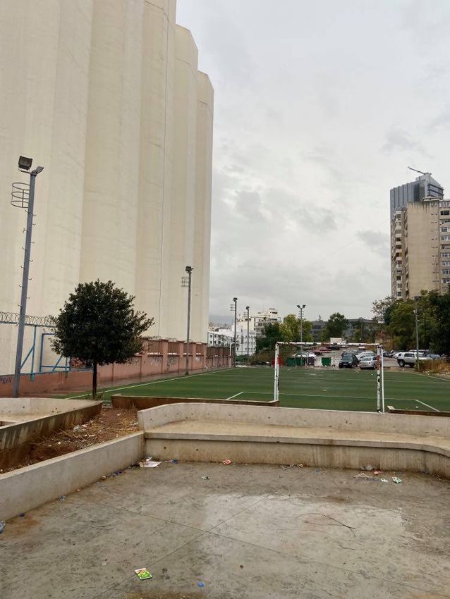
located in el-Ghabi Street and is more than 100 years old. Another landmark is the football pitch
located close to the Peugeot and Kia garage center, as this site attracts many youth and adults
from different nationalities to play together and exchange. Saydeh Church is also another landmark
which has historical significance and dates back more than 100 years. The stairs of Karm el-Zeitoun
are also major physical features that are very much used as social spaces by dwellers, as often
observed.
There is one notable landmark in Fassouh neighborhood: The Church of St. Peter and Paul. In
addition, there are two high schools: Chahrouri High School and Salma Sayegh High School (Map 3).
2. Historical Overview
A discussed in Najem’s thesis and UN-Habitat report, between 1920 and 1952, three groups of
camps emerged in Beirut as a direct result of the influx of Armenians, Syriacs and Palestinians into
6
Beirut due to violent conflicts and massacres in their countries of origin. Both studies inform us
about the social and urban history of the neighborhood, summarized hereafter. After the arrival of
10,500 Armenians in 1922, Medawar Camp in Karantina became the first slum in modern Beirut. In
1926, Armenian associations that were seeking disengagement from the camp proposed more
permanent solutions to Mandate authorities. This resulted in the gradual relocation of Armenian
refugees from Karantina to Bourj Hammoud and Khalil Badawi, Karm el-Zeitoun, and other low-
income neighborhoods in the city. These new areas were the most popular Armenian
neighborhoods at the time, and living conditions improved as these locations became consolidated.
New extensions emerged to the north of Karm el-Zeitoun with the arrival of Armenians from the
Sanjak of Alexandretta (now Hatay Province in Turkey) and other areas of Syria in 1939. The
establishment of Karm el-Zeitoun neighborhood in the 1930s was influenced by the demand for
Armenian artisan experience, combined with the establishment and growth of industrial zones at
the boundaries of the city of Beirut, hence attracting migrants to the neighborhood.
5
Najem, J.M. (2006). Community Participation as a Tool for Neighborhood Rehabilitation: the Case of Karm el-
Zeitoun. (Publication no. (u2313139) [Masters Thesis, American University of Beirut]. AUB University Libraries.
6
See Najem, J.M. (2006) op.cit., and: UN-Habitat (2018). Mapping Migration in Beirut Municipality: A
Comparative Study of Three Neighborhoods. https://unhabitat.org/sites/default/files/documents/2019-
07/mapping_migration_in_beirut_municipality2.pdf
7 | KARM EL-ZEITOUN URBAN SNAPSHOT | Working document
According to information from the Directorate General of Antiquities (DGA), both Karm el-Zeitoun
and Fassouh have buildings deemed as holding heritage value (Map 4). Following the blast, as per
gathered conversations, the DGA, with the support of experts and activists, surveyed
neighborhoods to identify additional buildings for heritage preservation. While no official listing is
available, repair and/or any other intervention on these buildings has to be cleared by the DGA by
order of the city's Governor. Consequently, the number of buildings with heritage protection has
increased though this ad-hoc arrangement.

3. Main Urbanization Trends at the Time of the Beirut Blast
The analysis of Karm el-Zeitoun and Fassouh’s urbanization trends reveals the complex changes the
                                         7
neighborhood have been going through. The aim of this analysis is to locate the current repairs
within the context of larger urban transformations that affect the neighborhood. By underscoring
these trends, the analysis helps the post-disaster recovery locate its immediate relief concerns
within the longer developmental needs of the neighborhood, particularly those that affect residents
and their livelihoods in the neighborhoods.

As mentioned earlier, Karm el-Zeitoun began as a camp settlement for Catholic Armenian refugees
who arrived to Lebanon fleeing the threat of Turkish massacres at the turn of the previous century.
                                                                                                 2
The French authorities who ruled Lebanon at the time provided them with a plot of land of 60 m .
Dwellers recall that the neighborhood was home to olive, fig, and pine trees, which can no longer be
seen today. Houses in Karm el-Zeitoun were built on one floor and included a small garden.
Progressively, residents began adding floors to their homes, in response to their needs.

However, today, as observed during field visits, the urban character of Karm el-Zeitoun
neighborhood is much more hybrid: with the introduction of concrete in Lebanon in the 1920s,
additional floors (up to three) were built on top of the old houses. On the other hand, in Fassouh
neighborhood (Zone 43) and Saydeh Street (Zone 61-a), most of the building blocks and houses are
hybrid in terms of building age, including a mix of contemporary buildings and older structures, in a
much less dense fabric (Map 5).

Gentrification

As per interviews, some of these old houses have been attracting developers who have been
purchasing the properties and eradicating the old houses to build high-rises and high-end
residential projects. It is not known who owns the lands that house new buildings in Karm el-
Zeitoun. Claims advance that the lands are owned by a Lebanese person who wanted to
intentionally displace the residents but that the Church and the Tashnaq Armenian party pressured
him not to. The landowner seems to have managed to convince a few individuals to leave their
homes, at the periphery of Zone 61.

Indeed, high-rise residential buildings were observed in Zone 61-a of Karm el-Zeitoun around
Saydeh Street, the area next to Kia and Peugeot garage center (Zone 61-b), and in Fassouh
neighborhood (Zone 43). More specifically, 11 situations which can be attributed to gentrification
were observed during the fieldwork in Karm el-Zeitoun, as well as 22 in Fassouh. These can be
divided in two categories: existing buildings that were built between 2000 and 2020, currently
inhabited; and new residential projects under construction or in the final stage of construction.

The largest two residential projects in Karm el-Zeitoun neighborhood are Ayoub Tower and Olive
Garden. Ayoub Tower is developed by Ayoub Projects, who, according to the Beirut Built
Environment Database (BBED), is a large real estate developer and has been in the business since
the 1950s. Ayoub Tower is made of two residential blocks served by several elevators, two

7
 These trends, and observations about building activities are all derived from the Beirut Built Environment
Database. Data about building permits was obtained by the Beirut Urban Lab from the Order of Engineers and
Architects in Lebanon in 2019 and all data points were surveyed to double-check their validity. Please check
the Methodology section in the beginning of this report or visit the BBED website for the detailed methodology
used to collect and analyze the data.

8 | KARM EL-ZEITOUN URBAN SNAPSHOT | Working document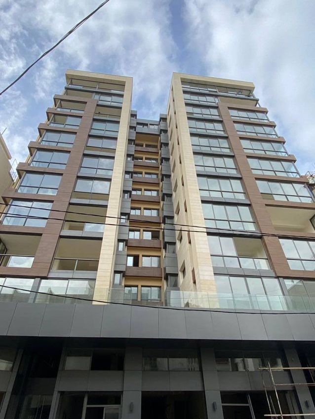
commercial floors and five underground basements as well as a parking garage located next to
Saydeh Church. Another person who works in Karm el-Zeitoun reported that prior to the
construction of the tower, several old two-story houses (including this person’s grandmother’s)
were destroyed. The shops on the ground floor are a variety of sizes with areas ranging from 73 to
362 sqm. Different apartment sizes are available in the residential tower, ranging from 92 to 320
sqm for one to three bedrooms, as well as some duplex apartments. The Olive Garden residential
project is located between several residential buildings in Zone 61-a, a few meters away from Cheikh
el-Ghabi street. It is made of two-bedroom apartments with amenities, including a cave, and parking
space. The Olive Garden residential project was built seven years ago, and the majority of its
apartments are currently inhabited.

Many old buildings were reported to have been destroyed and either replaced by new towers or the
plot has been left empty. For example, an old house located between Saydeh and Cheikh el-Ghabi
Streets was torn down and replaced by a ten-story building; another old building on Saydeh Street
was torn down several years ago where tenants and owners negotiated a financial deal to vacate,
and then a new building was erected; still on Saydeh Street, another old building was destroyed two
or three years ago and the plot is currently empty.

Moreover, in several locations in Karm el-Zeitoun neighborhood, seven to ten-story buildings were
also observed and reported to be built in the 2010s. Another old four-story building (Fig. 1) near
Peugeot and Kia garage centers will be destroyed soon and replaced by a new building. According
to residents in this building, all the tenants are based on the old rent scheme and have already
agreed on a financial deal with the lawyer of the building’s owner to leave their homes at the end of
November 2020. There is also a case where two two-story old buildings on one plot of land are
under threat of destruction: one is currently inhabited by two old people, whereas the second
building has been vacant for more than a year because the owners want to tear down the houses
and build new structures. New buildings were observed to be under construction as well in Zone 61-
a, around Saydeh Street.

Figure 1. Old building where tenants negotiated a financial
deal to vacate as it will be demolished to build a new one,
Karm el-Zeitoun. Source: Makram Robehmed, 2020.

9 | KARM EL-ZEITOUN URBAN SNAPSHOT | Working document
Gentrification trends in Fassouh are stronger than Karm el-Zeitoun, as one can experience the
changing urban character of the neighborhood through the presence of many new residential
projects, almost on every street. On Ghophrael Street alone, eight buildings have been built
between 2005 and 2020. One of the biggest residential projects in Fassouh is the ESLA tower (Elias
Saad Leading Association), located at the beginning of Messarra Street. This tower consists of 12
residential floors, a large commercial area divided into three floor levels, and a four-floor
underground parking. The 12 residential floors consist of twelve simplexes with an area ranging
from 263 to 271 sqm, and six duplexes with an area of 338 sqm. The commercial area consists of six
shops and two showrooms, ranging from 71 to 274 sqm. In Karm el-Zeitoun Street, a big residential
project by the Lteif family is in its final stage of construction (Fig. 2).

Many old houses and buildings in Fassouh were demolished to rebuild these new buildings, mainly
for-profit purposes. One owner of a new building dating back to 2013 reported co-owning an old
three-story building with family members that was inhabited by tenants on the old rent scheme.
Then, they arranged a financial deal with the tenants to vacate the building to invest in this eight-
story building. Around Chahrouri area, a ten-story modern building is reported to have replaced an
old house. Similarly, another owner of a two-story house on St. Peter and St. Paul Street destroyed
it to build a new nine-story building where he and his children currently reside. Two old,
deteriorated buildings in Ghophrael Street were also demolished in October, though it is unclear
whether it is related to the blast or not.

Figure 2. New residential building in its final stages
of construction, Fassouh. Source: Makram Robehmed,
2020.

New projects under construction were also observed in Fassouh. At the border of the Independence
highway, a large-scale residential project is in its early stage of construction (Fig. 3). It was reported
that this land was originally owned by a Turkish family who sold it to a Lebanese person, who then
sold it again. The project includes 14 residential floors, with five underground floors and one
commercial space of 500 sqm on the ground floor. However, the project was stopped because
archeological remains were found during the excavation.

Figure 4 shows the distribution of building permits in Karm el-Zeitoun/Fassouh areas between 1996-
2018, compiled from the BBED data that highlights the real estate development trend in the
neighborhoods, as compared to the trends in municipal Beirut (Map 7). The BBED project reveals
that the building development sector in Karm el-Zeitoun and Fassouh has undergone several
fluctuations between 1997 and 2018, roughly following the trends of the larger market. Thus, the

10 | KARM EL-ZEITOUN URBAN SNAPSHOT | Working document
post-war real estate crisis in 1997 caused the neighborhoodto slow down in building activities. The
graph further reveals the impacts of Lebanon’s Central Bank interventions as of 1997, as it sought
to incentivize banks in intervening on the real estate sector, either directly by facilitating
transactions in the sector or channeling the flow of domestic and external capital to the building
          8
industry. The graph also shows the solid trend of building activities as of 2007, with the
financialization trends taking an important toll on the neighborhood. The 2018 Beirut Urban Lab
survey showed that vacancy rates were above 30% in new buildings, that several buildings in the
neighborhoods had seen all their residents evicted without new construction activity being initiated,
and that other buildings were demolished and stand today as empty lots and/or parking lots. These
all point to the speculative investments taking place and the shift towards assigning a higher value
                                                                         9
for property as an investment over the social value of land as shelter.

Figure 3. New residential project in its early stage of
construction, Fassouh. Source: Makram Robehmed,
2020.

9
  Fawaz, M., & Mneimneh, S. (2020). Beirut’s blasted neighborhoods: Between recovery efforts and real estate
interests. The Public Source. https://thepublicsource.org/beiruts-blasted-neighborhoods-between-recovery-
efforts-and-real-estate-interests

11 | KARM EL-ZEITOUN URBAN SNAPSHOT | Working document
Distribution of building permits (1996-2018):
Karm el-Zeitoun vs Municipal Beirut
8 200
7
Karm el-Zeitoun
6 150
Municipal Beirut
5
4 100
3
2 50
1
0 0
1996
1997
1998
1999
2000
2001
2002
2003
2004
2005
2006
2007
2008
2009
2010
2011
2012
2013
2014
2015
2016
2017
2018
Karm el-Zeitoun Total in Beirut
Figure 4. Graph of Building Permits in Karm el-Zeitoun and Municipal Beirut. Source:
Beirut Built Environment Database (BBED), Beirut Urban Lab, 2020.
Abandonment
Eighteen cases of partial and full abandonment in Karm el-Zeitoun were observed during our
fieldwork. In one location in Karm el-Zeitoun, a resident complained about an abandoned unfenced
plot facing his house for the past two years, which becomes a nuisance during rainstorms when
water, stones, and trees branches end up either in front of or inside his house. In another location
around el-Ghabi Street, there is a three-story building with two abandoned floors since the Civil
War, one inhabited floor and one convenient store. Several abandoned shops were identified as well.
At the end of the street that is facing Inaty Bakery, often called Shaneaa Street, there are four
abandoned shops located next to each other in one location, and one other abandoned shop in
another location. It was also reported that many empty lots that were used for parking are now
abandoned due to legal problems and/or construction permits.
Figure 5. An abandoned building owned by the Armenian
Waqf, Karm el-Zeitoun. Source: Makram Robehmed, 2020.
12 | KARM EL-ZEITOUN URBAN SNAPSHOT | Working documentThere were cases of eviction threats (forced abandonment) reported by both residents and building owners in Karm el-Zeitoun. For instance, it was reported that a family who lives in an old building located next to two other old, abandoned buildings (Fig. 5) in one plot owned by the Armenian Waqf is undergoing a lawsuit that aims to evict the family in order to destroy the buildings and construct new ones. It was also reported by the family that the other two old buildings were inhabited several years ago by old rent tenants. A few years ago, the lawyer of the Armenian Waqf negotiated a financial deal with the renters and accordingly they vacated their houses, which remain empty and abandoned. Another case is with a building owner who evicted at least two households who paid old rent after the latter breached the rental contract by defaulting on several payments. Another case is one resident who was forcefully evicted from his house in a two-story building with a ground floor, totaling five apartments, where four families were displaced from their homes since the owner decided to raise the monthly rent from 450,000 LBP to 600,000 LBP after the blast. Similarly, more than twenty cases of partial and full abandonment were observed in Fassouh. In Karm el-Zeitoun Street, there is a two-story building which has been fully abandoned for over five years (Fig. 6). The original owners who live abroad have sold it. Meanwhile, there are many buildings that have been abandoned for more than 10 years including an old house next to Chahrouri Palace on St. Peter and Paul Street; four dilapidated buildings and houses next to Charles Malek highway; three floors and five commercial shops of a five-story old building on Ghophrael Street; and one apartment in a four-story building on Messara Street. Many abandoned buildings and parking lots have graffiti on their walls. One two-story heritage house on Ghophrael Street is partially abandoned. Additionally, the “Uruguay” high school relocated to Sin el Fil, and its old abandoned building remains empty in the neighborhood. Figure 6. Abandoned two-story building that has recently been sold, Fassouh. Source: Makram Robehmed, 2020. Impoverishment Impoverishment is highly visible in Karm el-Zeitoun neighborhood, mainly due to loss of livelihoods driven by the economic collapse marked by the devaluation of the Lebanese pound and COVID-19, which has led to high unemployment and a high cost of living. During fieldwork, the majority of the residents in Karm el-Zeitoun complained about the economic situation, and the Armenian Church priest confirmed that the majority of people are poor and always complain about unemployment and the cost of living. Indeed, the majority of families interviewed have unemployed members. Some resident interviewees claimed they are employed with low salaries, or unemployed and receive financial support from either family or friends as well. Few cases have access to sources of financial support. For instance, an elderly woman who lives next to Kia and Peugeot garage centers said that her children provide her with medical and financial support every month. Another person who inherited an old one-story house from his father, said 13 | KARM EL-ZEITOUN URBAN SNAPSHOT | Working document
that he received financial support from his brother to repair home damages from the blast because
he could not afford to since the restaurant where he worked shut down. Another case is that of a
resident who was working in the neighborhood and was let go by the business owner who had to
reduce the number of employees: he receives financial support from his brothers who have jobs in
hospitals. One tenant is a self-employed contractor, but due to the economic burden and his medical
condition affecting his source of income, he defaulted on nine monthly rent payments, but the
landlord, an elderly woman, is being patient.

More than fifteen shops were reported to have closed in Karm el-Zeitoun neighborhood as a
consequence of the blast, the pandemic and the economic crisis. A year ago,
three furniture galleries closed in one location, as well as another four shops including a
mobile shop and a DVD shop. Also, two beauty stores have been highly damaged by the blast and
are still closed. One bookstore closed a year ago due to the economic crisis, and a branch of
Petit Creux restaurant closed due to the damages caused by the blast. Similarly, more than twenty-
five shops were reported to have closed in Fassouh neighborhood (a gas station, a clothing shop, a
hairdresser, a vegetable seller, two restaurants, a furniture gallery, among others).

There have been many recent cases of migrant workers in Karm el-Zeitoun leaving their houses and
Lebanon as well, due to the multiple crises. Migrant workers have low-skill jobs mainly in food and
convenience stores, as well as in construction and repair activities. Some of the migrants work as
concierges in buildings and do not have rent fees. Some work a second job. For instance, in el-Ghabi
Street, a male migrant worker from Bangladesh, who used to live with five other migrant workers
last year mentioned that two of his flat mates have already traveled, and he booked his ticket to
leave by the end of 2020. Another male migrant from Sudan also mentioned that he and his nine
flat mates are planning to leave the country for similar reasons. In addition, an Ethiopian female
married to a Lebanese old man, who runs a beauty shop in Karm el-Zeitoun neighborhood, said that
many of her clients (migrants from Ethiopia) have already left Lebanon, while others are saving
money and planning to leave the country as soon as they can due to the lira devaluation.

One of the urban trends in Karm el-Zeitoun that has been developing throughout the past decade is
the rental market targeting migrant workers. The majority of migrant workers observed live in
groups of four to ten persons in one-two bedroom apartments and pay their monthly rent based on
the new rent scheme. Impoverishment has thus impacted this market as many migrant workers
have been leaving the neighborhood. A Lebanese developer claims to own eight dilapidated
buildings in el-Ghabi Street. He said he purchased them to provide free accommodation – as well as
secure cheap housing – for the migrant workers who work for him in the cleaning and general
contracting company he owns (Window Cleaner), located nearby in Sioufi. However, many of the
migrant workers that worked for him have left the country. One of his buildings accommodates
about twenty-five migrant workers (a majority from Bangladesh).

Unlike Karm el-Zeitoun, the migrant community in Fassouh neighborhood is small. None of the
residents mentioned they were planning to leave the country. The majority of migrants interviewed
were from Syria, the others being from Sudan, Ethiopia, Bangladesh and Egypt. One migrant from
Syria who has been living and working in a public parking lot for more than fifteen years, has
managed to support his son-in-law who has been defaulting on rent.

Vacancy

While in Zones 61 and 61-b, building conditions are poor and deteriorated, in Zone 61-a of Karm el-
Zeitoun (around Saydeh Street) and in Zone 43 of Fassouh neighborhood, buildings are in much
better condition, and the livability standards are higher. Fieldwork showed that both old and new
buildings are partially vacant in both neighborhoods. For instance, in Ayoub Tower in Karm el-
Zeitoun neighborhood, many residential apartments and shops are still vacant. In a new building in
Saydeh Street constructed seven years ago, five out of ten apartments (160 sqm each) are vacant,
and the monthly rent required is 1,200 USD, while the exchange rate is said to be negotiable. A one-
story building, owned by the aforementioned cleaning company, is totally vacant. Several dwellers
reported that the rent in some buildings depends on the currency payment irrespective of the
nationality, meaning that “fresh” dollars are desirable over the Lebanese pound.

An increasing number of vacancies is noted within Karm el-Zeitoun in the sections that used to be
rented by migrant workers. According to the data from BBED for apartments granted permits since
1996, Karm el-Zeitoun has the highest rate of vacancy (23%) among the six other neighborhoods.

14 | KARM EL-ZEITOUN URBAN SNAPSHOT | Working document
The total number of apartments in Karm el-Zeitoun neighborhood that were assessed is 316,
whereby 212 are occupied (67%), and 104 are vacant (23%), of which 79 are for sale and 25 are sold
and empty. The market in the neighborhood has seemingly more housing stock available than is
required between landlords and tenants.

In Fasssouh, vacancy rates were also high especially among the completed new buildings and those
under construction. On Ghophrael Street, a vacant apartment in a new building requires a monthly
rent of 2,000 USD. A new building facing Chahrouri Palace contains 26 apartments that are
currently vacant (neither sold nor rented yet). This building is still under its final stages of
construction and was subject to delay due to the damages caused by the blast. Another residential
project located next to Independence highway is still in its early stages of construction. Vacancy
was also noted in many old buildings, with small apartments available for rent.
To conclude, based on the several trends that were observed and reported by residents interviewed
in both neighborhoods, and based on the findings of the fieldwork, Karm el-Zeitoun is a
neighborhood severely impacted by impoverishment related to job loss and loss of income,
abandonment and vacancy driven by both lira devaluation and, as a result, migrants who are leaving
the country. Similarly, Fassouh is a neighborhood severely impacted by gentrification driven by
developers who have been purchasing old buildings, demolishing them and replacing them with
high-rises and high-end residential projects. In addition, the neighborhood is marked by MSMEs
closures, abandonment, and vacancy related to the lira devaluation especially in new residential
buildings that contain many apartments for rent and for sale.

4. Socio-Demographic Profile
As a result of the internal displacement caused by the Lebanese Civil War (1975–1990), the post-
Civil War period has been characterized by demographic shifts, as migrant workers seeking to work
on reconstruction projects arrived to Beirut from Syria, Egypt and other Asian and African
countries.

As observed and reported by the people interviewed during fieldwork, Karm el-Zeitoun has a
heterogeneous living environment, where space is shared by individuals of multiple nationalities.
Karm el-Zeitoun’s dwellers have mixed origins, with some buildings housing mainly migrant
communities. As such, Lebanese and Syrians share residential units, and many migrants from
Bangladesh, Ethiopia, Sudan, Egypt, Philippines, and Sri Lanka also share homes. In many cases,
residential units were shared by a large number of dwellers, likely to constitute overcrowding. One
of the mokhtars claimed that more than half of the people living in Karm el-Zeitoun are not
Lebanese and come from Syria, Bangladesh, Ethiopia and other low-income countries. The mokhtar
also mentioned that the majority of Lebanese residents’ rent in Karm el-Zeitoun is based on the old
rent scheme, while several are homeowners. Conversely, the majority of migrant residents live in
shared accommodation and pay rent on the new scheme. The Technical Assessment conducted by
UNHCR’s partner between September and December 2020 provides some elements of information
concerning nationality of residents among assessed housing units, although because of their status
                                                                                 10
and vulnerability, it is likely that non-Lebanese populations are under-reported. Among the 188
assessed housing units of Karm el-Zeitoun on the topic of nationality, close to 24% of the residents
declared not being non-Lebanese (of whom 31 Syrians), while 27% preferred not responding to the
question.

On the other hand, Fassouh neighborhood is characterized by a higher social class compared to
Karm el-Zeitoun, as confirmed by the mukhtara. Dwellers in the neighborhood are mostly Lebanese
who have relatively higher levels of education and stable employment. Several families are old
inhabitants who are property owners, sometimes owning whole buildings. The majority of the
people interviewed in Fassouh are well-connected and receive support from family members who
also have secure jobs. In one location, one woman who lives with her husband receives support from
her daughter who is married to an engineer, and financial support from her four sons. She used to
rent her apartment on the old rent law, but then her son-in-law bought the apartment from the
owners and she now lives in it securely. In another location, an elderly woman who lives with her

10
  Anecdotal information has circulated since the Beirut Port Blast that indicates that vulnerable tenants were
being evicted or under-reported as landlords sought to collect their rents. For more on the status of vulnerable
populations, please refer to the body of work about Syrian refugees produced by the Legal Agenda at
https://english.legal-agenda.com/country/lebanon/.

15 | KARM EL-ZEITOUN URBAN SNAPSHOT | Working document
husband and her single sister, pay rent based on the new rent scheme. Her son who lives in France
supports them. Her single sister also inherited their father’s monthly salary, as he was a public
employee.
Several of the people interviewed in Fassouh have a secured pension that helps them support
themselves and their families. For example, an elderly woman’s husband owns an old three-story
building he rents out and thus secures regular income. She is a retired Lebanese University
professor who still receives her retirement salary. She lives with her two single and unemployed
children: a son who stopped working one year ago due to the lira devaluation, and a daughter who
stopped working twenty years ago because the school where she taught closed.
5. Housing Conditions
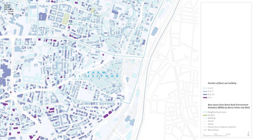
The majority of the housing stock in Zones 61 and 61-b was built prior to 1940 (Map 5). Indeed, as
shown on the building height map, the majority of buildings in Karm el-Zeitoun count one to three
floors (Map 8). There are some one to two-story houses as well. Many buildings were further added
after 1940. As observed, and as confirmed by a civil engineer who works for an INGO working in the
shelter repair process in Karm el-Zeitoun, almost all the buildings have acceptable quality
conditions in terms of windows, doors, foundations and infrastructure.
In Zone 61-a, the majority of housing stock was built between 1950s and 1970s. There are also
several buildings that were built between 1970s and 1980s. Fewer buildings were built after the
1990s. Almost all the buildings observed around Saydeh Street in Zone 61-a and Fassouh (Zone 43)
are old and four- to eight-stories while many modern buildings are seven to thirteen stories. The
majority of buildings in Zone 61-a are in relatively better condition than the ones in Zones 61 and 61-
b.
According to the data received from BBED, there are 825 buildings in Karm el-Zeitoun-Fassouh
(Map 2). In Fassouh, the housing stock reflects the layers of historical development with a few pre-
1940s buildings, a substantial stock of modern development dating back to the 1950- 1980 period,
and a handful of post-1990s recent structures (Map 5). The BBED survey indicates a high rate of
building redevelopment with more than 15% of the total buildings in Zone 43 having been built after
1996 (Map 6).
Forms of Tenure
There are several forms of tenure in both Karm el-Zeitoun and Fassouh, as reported during
fieldwork. The neighborhood counts a mix of forms of tenure, including both old and new rents,
property owners, as well as a handful of informal arrangements in which the occupants have
received access to an apartment as part of their employment benefits. A quick comparison across
the two neighborhoods shows that Karm el-Zeitoun tends to count a higher number of tenants,
evenly distributed between old and new rents while Fassouh has a higher rate of property owners.
Short of a full survey, the full distribution of these patterns is difficult to assess. The Technical
11
Assessment led by UNHCR’s partner in Karm el-Zeitoun covered 189 housing units regarding the
mode of occupancy: among those, the large majority (76%) of residents were tenants, out of which
33% on old contracts, and 43% on new contracts. The rest owned their homes (22%), while 1.6%
said they had hosting arrangements. Of those on rental contracts, almost half (48%) relied on
verbal agreements, highlighting the precarity of their form of tenure among assessed residents, and
their potentially high levels of vulnerability.
According to the survey of loans disbursed by the Public Corporation for Housing (PCH) (Map 9),
there are seventeen cases of PCH Loans in Karm el-Zeitoun, mainly around Saydeh Street. On the
other hand, in Fassouh, thirty-five PCH loans have been recorded—confirming again the difference
in socio-economic classes between both sections of the area. New homeowners tend to purchase
their homes either directly or through private bank loans. Quite a few benefit from the subsidized
public loan of the PCH in this neighborhood. The cost of land in Fassouh specifically and the large
11
As explained above, the technical assessment was not designed based on probability sampling, and thus does
not provide statistically significant data. However, it can still be used as informative analysis.
16 | KARM EL-ZEITOUN URBAN SNAPSHOT | Working document12 rent gap kept these apartments above the means of their residents, exacerbating further the landlord/tenant relations and threats of eviction. 6. Local Economy More than 140 shops were counted in Karm el-Zeitoun, distributed across the area (Zones 61, 61-a and 61-b). Cheikh el-Ghabi Street includes the largest concentration of shops while Saydeh Street also includes many shops. There are also many shops that operate within the internal streets of the neighborhood serving the residential buildings. The majority of businesses are either small or medium in size, ranging from 15 to 120 sqm, including but not limited to food and convenience, service, clothing and beauty shops. Few larger businesses exist in the neighborhood (e.g. Kia and Peugeot repair centers in Zone 61-b; Byblos Bank and SGBL branches in Zone 61-a; and the Total gas station). Many businesses in the neighborhood are owned by Lebanese. It was also noted that there are several stores owned by elderly who do not have employees. There are several cases of businesses based on the new rent scheme and many cases of informal rental agreements. In one location, a person rents a small convenience shop and pays 300,000 LBP per month (based on a verbal contract with the owner). Another case is an Ethiopian female owner of a shop, who pays 900,000 LBP per month (based on a verbal contract with the owner). An elderly Lebanese runs a clothing shop and also pays 900,000 LBP monthly (based on a paper contract with the owner). One shop is operated by two people who split the monthly rent amount of 1,000,000 LBP. Many businesses in Karm el-Zeitoun employ migrant employees. The staff in the gas station and in the vegetable and convenience stores include workers from Bangladesh. Beauty and clothing stores employ migrants mainly from Ethiopia, while convenience stores employ migrants from Bangladesh. Migrants from Syria were observed to be employed mainly in the construction sites. The local economy in Fassouh neighborhood is quite different: It is less dense and more formalized. Messara and Ghophrael Streets include the largest concentration of shops while larger businesses are found at the intersection of St. Lois and St. Peter and St. Paul Streets (e.g. Wooden Bakery, Le Caddie Supermarket and two large fruit and vegetable stores). At the end of Messarra Street, there is a branch of Bank of Beirut, and at the middle of the same street there is a gas station (Medco Dagher). There are also a few shops that serve the internal streets of the neighborhood, many owned by elderly. More than 110 shops were counted in Fassouh neighborhoods, whereby the majority of businesses are either medium or large in size, ranging from 50 to 200 sqm. including food and convenience, service, clothing and beauty shops. The Rizk Group advertising company is housed in a modern seven-story building in Ghophrael Street, with its 40+ employees. Many businesses employ migrant employees from Syria, Egypt and Bangladesh. A few shops are small and operated by one person. 7. Quality of Public Spaces The streets of Karm el-Zeitoun are narrow in Zones 61 and 61-b, whereas they are wider around Zone 61-a and Fassouh neighborhood. Cars parked on both sides of the streets characterize both Karm el-Zeitoun and Fassouh, restricting pedestrian access and adding to the congestion during the day. Many buildings do have private parking in Fassouh and more than eight parking lots were observed with a capacity ranging from 25 to 60 cars. Some parking lots have private gates and remote controls, and they are based on monthly subscriptions, which range from 150,000 to 180,000 LBP. 12 The rent gap is a concept that points to the tendency of neighborhoods to attract higher investments when the difference widens between, on one hand, the current profit (or rent) accumulated from property ownership and, on the other, the potential profit that could be reaped if residents were evicted and /or the building was altogether replaced by a new, typically higher building. In Lebanon, the rent gap is generally the outcome of three overlapping regulations. These are: (i) rent control, (ii) heritage preservation laws, and (iii) building development regulations. For more information, refer to: Smith, N. (1987). Gentrification and the Rent Gap. Annals of the Association of American Geographers, 77(3), 462-465. http://www.jstor.org/stable/2563279. 17 | KARM EL-ZEITOUN URBAN SNAPSHOT | Working document
You can also read