STOKE NEWINGTON CONSERVATION AREA APPRAISAL
←
→
Page content transcription
If your browser does not render page correctly, please read the page content below
STOKE NEWINGTON
CONSERVATION AREA APPRAISAL

                        The Conservation and Design Team
                                Planning and Transportation
                                London Borough of Hackney
                                    Dorothy Hodgkin House
                                          12 Reading Lane
                                                   London
                                                   E8 1HJ

             This document has been written and illustrated by
                                  The Conservation Studio
                                              1 Querns Lane
                                                  Cirencester
                                               Glos GL7 1RL
                                          Tel: 01285 642428

                                          November 2004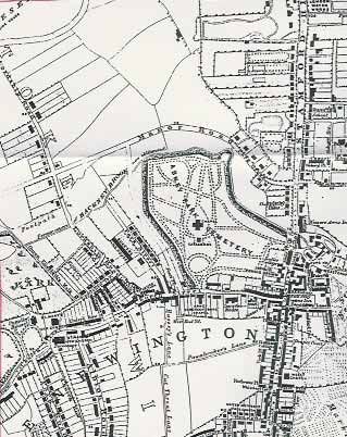
2

Stoke Newington Conservation Area Appraisal   November 2004
3

CONTENTS

1      Introduction
       1.1    The format of the Stoke Newington Conservation Area Appraisal
       1.2    Acknowledgements

2      Planning Context
       2.1   National Policy
       2.2   Local Policies

3      The Historical Development of the Area
       3.1   Archaeology
       3.2   Historical development
       3.3   Geology and topography

4      The Conservation Area and its Surroundings
       4.1   The Surrounding Area
       4.2   General description of the Conservation Area
       4.3   Streetscape
       4.4   Views, focal points and focal buildings
       4.5   Landscape and trees
       4.6   Street surfaces, street lighting and street furniture
       4.7   Activities and uses

5      The Buildings of the Stoke Newington Conservation Area
       5.1   Introduction
       5.2   Listed buildings
       5.3   Buildings of Local Significance
       5.4   Buildings of Townscape Merit

6      Character Areas
       6.1   Stoke Newington High Street and Stamford Hill
       6.2   Stoke Newington Church Street
       6.3   Abney Park Cemetery

7      Urban Design and Development Control principles
       7.1   General introduction
       7.2   Street frontages and boundary treatments.

Stoke Newington Conservation Area Appraisal                          November 2004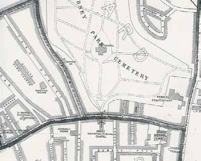
4

       7.3     Building Heights
       7.4     Roofs and Parapets
       7.5     Extensions and alterations
       7.6     Windows and doors
       7.7     Materials
       7.8     Shopfronts
       7.9     Listed buildings
       7.10    New development
       7.11    Setting and views into and out of the Conservation Area.

8      “SWOT” Analysis
       8.1 Strengths
       8.2 Weaknesses
       8.3 Opportunities
       8.4 Threats

Stoke Newington Conservation Area Appraisal                         November 2004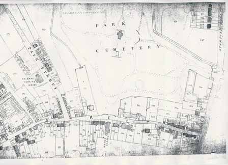
5

APPENDICES

Appendix A     Proposals for the Area at April 2004.
     A1        Grant aid
     A2        Improvements to open spaces
     A3        Shopfronts
     A4        Street improvements
     A5        Alterations to the Conservation Area boundary

Appendix B Schedule of Properties in the Conservation Area

Appendix C Schedule of Listed and Locally Listed Buildings

Appendix D List of buildings requiring repair or restoration at December 2003

Appendix E Bibliography

Appendix F Maps of the Conservation Area

Appendix G List of illustrations

Appendix H Further information

Appendix I     Copy of Council’s original Designation Committee Report (1983)
                     and Extension Committee Report (1985)

Appendix J     Copy of Council’s Cabinet Report Adopting the Revised Conservation
               Area Boundary and Appraisal
               (To be added following formal adoption of the Appraisal & final recommendations)

Stoke Newington Conservation Area Appraisal                                   November 2004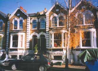
6

1      INTRODUCTION

Stoke Newington Conservation Area was originally designated in 1983, and was
extended to include Abney Park Cemetery in 1985. Formal, written appraisals of the
area were not produced at those times. The research and assessment of the area’s
special interest, undertaken for this appraisal, has enabled further consideration of the
boundaries of the Conservation Area to be undertaken.

1.1    The format of the Stoke Newington Conservation Area Appraisal

This document is an “appraisal” document as defined by English Heritage in their
guidance document “Conservation Area Appraisals”.

The purpose of the document is, to quote from the English Heritage document, to
ensure that “the special interest justifying designation is clearly defined and analysed
in a written appraisal of its character and appearance”. This provides “a sound basis,
defensible on appeal, for development plan policies and development control
decisions” and also forms the basis for further work on design guidance and
enhancement proposals.

This appraisal describes and analyses the particular character of the Stoke Newington
Conservation Area. This includes more obvious aspects such as its open spaces,
buildings, and architectural details, as well as an attempt to portray the unique
qualities which make the area “special”. These include less tangible characteristics
such as noise or smell, and local features which are unique to the area, such as the
very special environment which is created in Abney Park Cemetery by the trees,
pathways, graves and monuments.

The document is structured as follows. This introduction is followed by an outline of
the legislative and policy context (both national and local), for the Conservation Area.
Then there is a detailed description of the geographical context and historical
development of the Conservation Area and a similarly detailed description of the
buildings and the three different “Character Areas” of Abney Park Cemetery, Stoke
Newington Church Street and Stoke Newington High Street. Urban design and
development control issues are examined, and this is followed by a “SWOT” analysis
to clarify and summarise the key issues affecting the area. A number of Appendices
contain supplementary information including “Recommendations” (at April 2004),
schedules of the streets within the Conservation Area, listed and locally listed
buildings, and a list of buildings requiring repair. Appendix E provides a bibliography.
Maps and illustrations are included at Appendices F and G. Appendix H notes
sources of further information, and copies of the Council’s original Designation Report
and Cabinet Report, endorsing the CAAP, are included at Appendices I and J.

Stoke Newington Conservation Area Appraisal                          November 2004
7

1.2    Acknowledgements

This document has been drawn up with the help and assistance of the Stoke
Newington Conservation Area Advisory Committee, who have contributed to the
drafting of the document and who have made comments on the proposals contained
within it.

For details of how to become involved with your local conservation area advisory
committee please contact the Hackney Society, contact details of which are given in
Appendix H.

Stoke Newington Conservation Area Appraisal                      November 2004
8

2         PLANNING CONTEXT

2.1       National policies

Individual buildings “of special architectural or historic interest” have enjoyed a means
of statutory protection since the 1950s, but the concept of protecting areas of special
merit, rather than buildings, was first brought under legislative control with the passing
of the Civic Amenities Act in 1967. A crucial difference between the two is that listed
buildings are assessed against national criteria, with lists being drawn up by the
government with advice from English Heritage. Conservation Areas, by contrast, are
designated by local authorities on more local criteria, and they are therefore very
varied - small rural hamlets, mining villages, or an industrial city centre. However,
general guidance on the designation of Conservation Areas is included in Planning
Policy Guidance Note 15 (PPG15), which sets out the government’s policies on the
historic built environment in general. By 2004, the London Borough of Hackney had
designated 22 conservation areas.

2.2       Local Policies

Legislation and guidance has emphasised the importance of including firm
Conservation Area policies in the Unitary Development Plan (UDP), which must in turn
be based on a clear definition of what constitutes that “special architectural or historic
interest” which warranted designation in the first place.

The Environmental Quality chapter of Hackney’s Unitary Development Plan of 1995
contains Policies EQ11 to 15, concerning the designation and control of Conservation
Areas. The justification to Policy EQ15 explains that the existing historic areas within
the Borough fall roughly in four groups, and as staff resources permit, the Council will
consider the designation of further Conservation Areas, and the amendment of
boundaries to existing Conservation Areas. These groups are:

      •   Town centres and village cores: with buildings of varying age and type that will
          also include Georgian and Victorian ribbon development; for example, Dalston
          Lane and Broadway Market.

      •   Residential areas: especially areas characterised by villas – a particularly well
          developed Hackney building type.

      •   Open spaces and their settings:       for example, London Fields and Stoke
          Newington Common.

Stoke Newington Conservation Area Appraisal                             November 2004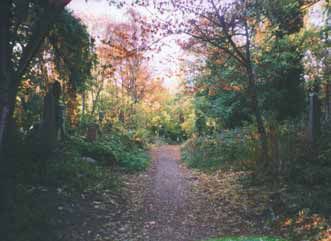
9

   •   Industrial Heritage: for example, the Regent’s Canal and Waterworks Lane,
       Lea Bridge.

The Stoke Newington Conservation Area falls into both the first and the third group, as
it contains an historic village core and an important open space (Abney Park
Cemetery).

Stoke Newington Conservation Area Appraisal                         November 2004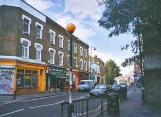
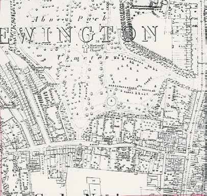
10

3      THE HISTORICAL DEVELOPMENT OF THE AREA

3.1    Archaeology

To the north of the Conservation Area, the Abney Park Cemetery forms part of an
extensive Palaeolithic working floor containing axes, hammer stones and flakes.
Despite the presence of Ermine Street, along which Kingsland Road and Stoke
Newington High Street run, few artefacts of the Roman period have been discovered.
The only notable find in the vicinity is a stone sarcophagus, discovered in Lower
Clapton.

There are no Scheduled Ancient Monuments in or near the Stoke Newington
Conservation Area, although the former line of the New River, and the section of
remaining river, in the adjoining Clissold Park Conservation Area, have archaeological
significance.

3.2    Historical development

In the late Saxon period Hackney formed part of the manor of Stepney, which had
been held by the Bishops of London since the early seventh century, when King
Athelbert gave lands and their incomes to support St Paul’s Cathedral. Hackney has
no separate entry in the Domesday Survey of 1086, but the name is recorded in 1198
as “Hacas ey“, a Saxon word meaning “a raised place in the marsh”. It is likely that
there were Saxon settlers at Stoke Newington although the “ing” form of the name
Newington is not recorded before the 13th century. The first mention of Neutone is in
the Domesday Survey of 1086, when it still formed part of the demesne of St Paul’s
Cathedral. The prefix Stoke, first recorded in 1274, was used to distinguish the village
from Newington Barrow or Newington Berners in Islington. The prevailing activity was
agriculture, with the land being occupied by the Bishop’s tenants, who grew hay and
food for the inhabitants of the nearby City of London.

The early settlement of Stoke Newington was based on the Manor (located beneath
the modern Town Hall) and the church, the earliest record of which dates back to
1314, when a rector was appointed. In the 1930s, when the Town Hall was built, the
chalk and Kentish ragstone foundations of the old medieval manor house were
uncovered.

Stoke Newington Conservation Area Appraisal                          November 2004
11

                          Figure 1 Drawing of St Mary’s Church c.1800

The Lordship of the Manor of Stoke Newington has remained in the ownership of the
church into the 21st century. A prebendary of Stoke Newington was recorded from
c.1104, and the manor, co-extensive with the parish, remained the property of the
prebendary until vested in the Church Commissioners in 1843 under the Act of 1840,
except during the Interregnum in the mid-17th century when parliamentary
commissioners sold it to the lessee. In 1972 the Church Commissioners refused a
request from the Stoke Newington Society to buy the Lordship of the Manor.

Stoke Newington therefore remained a small manorial village, its economy based on
agriculture, during the late medieval period. In the 15th and 16th centuries new houses
were built along Church Street and leased to courtiers and merchants, escaping the
unhealthiness of the city of London. Following the Reformation of the 1540s,
influential owners of the Manor included William Patten and then John Dudley, a rich
brewer who died in 1580. In 1558 the manor house was described as badly neglected
but by 1565 Patten had carried out extensive repairs. He also repaired St Mary’s
Church, rebuilding the tower and the south aisle. It is said that Queen Elizabeth I
visited Stoke Newington as a guest of Dudley, who was a kinsman to Earl of
Leicester, her favourite. This visit is reflected in the naming of Queen Elizabeth’s
Walk on the northern edge of Clissold Park, which appears on early 18th century maps
as a public walk. In Church Street, the Rose and Crown Inn existed in 1612 and the
Red Lion is noted in 1697.

Between 1608 and 1613, the New River was built to provide fresh water from
Hertfordshire to New River Head, near Sadlers Wells. This would have added to the
attractions of the Hackney area, as clean water was difficult to find. The New River
meandered through the north end of the parish, with a loop which passed through

Stoke Newington Conservation Area Appraisal                             November 2004
12
what is now Clissold Park. Alterations in 1724 and again in 1946 have left just a short
truncated section in the park, now used as an ornamental lake.
During the 17th century, despite the upsets of the Civil War, a number of prestigious
houses were built in Stoke Newington. Fleetwood House was erected in c.1634 by Sir
Thomas Hartopp, a Parliamentary supporter, whose early death in 1658 resulted in his
wife remarrying Charles Fleetwood, after whom the house is named. Fleetwood was
the widower of Oliver Cromwell’s daughter, and later in the century the house became
the centre of non-conformist meetings, before the Act of Toleration of 1689 provided
that all non-conformists could worship in peace. In 1695 Thomas Gunstan, the then
lessee of the manor house, obtained permission from the prebendary to pull it down
and several houses, forming Church Row, were built on the site. Gunstan then set
about building a replacement to the manor house on land further eastwards along
Church Street, close to Fleetwood House, although he died in 1700 before the house
was complete. Gunstan left his estates to his sister Mary, wife of Thomas Abney,
(d.1722) Lord Mayor of London and a founder of the Bank of England. The
prestigious new red brick property was called Abney House, after Mary Abney, and
consisted of seven bays, set back from the road behind metal railings and gates.
These still remain and form the southern entrance to the cemetery, although the
house was demolished in 1843.
Figure 2 Drawing of Abney House
Other prestigious houses were built along Church Street during the 18th century, and
several of these remain and are listed grade II*. The most notable of these are nos.
81-87, on the south side of Stoke Newington Church Street opposite the entrance to
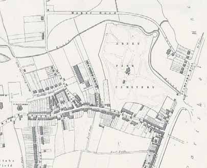
Stoke Newington Conservation Area Appraisal November 200413 Abney Park Cemetery. Slightly further westwards lie nos. 107-117 Church Street. These date to c.1700 and as such are the earliest surviving buildings in the Stoke Newington Conservation Area. The Abney’s only surviving child, Elizabeth, died in 1782 and it was under her will that the manor lease was sold for the benefit of dissenting ministers, establishing the connection, especially with the Quaker movement, for which Stoke Newington was to become famous. The area was also notable for its many writers, including Daniel Defoe, who lived in Church Street and who wrote Moll Flanders and Robinson Crusoe. The buyer of the lease on the Manor was Jonathan Eade, and it remained with his family until 1881, when the lease was sold to the Ecclesiastical Commissioners, who leased the demesne lands piecemeal until the 1950s when they sold most of the freeholds. This demesne land occupied most of the land north of Church Street with the manor house at its southern end, next to the church. The protection of this land from development during the 19th century has provided the Stoke Newington area with its two most important open spaces: Clissold Park and Abney Park Cemetery. In the 1830s a number of developers purchased land in the Stoke Newington area for new houses, and the fields to the south of Church Street were incrementally developed. The best known builder was Thomas Cubitt, who built a long row of villas along Albion Road, to the south of Church Street, only some of which remain due to war time bombing. The 1846 map shows how land was being laid out for new houses, generally set in generous gardens. Stoke Newington Conservation Area Appraisal November 2004
14

                                     Figure 3 Map of 1846

Stoke Newington Conservation Area Appraisal                 November 2004
15
Figure 4 Map of 1848
Stoke Newington Conservation Area Appraisal November 200416
Figure 5 Map of 1862
Stoke Newington Conservation Area Appraisal November 200417
Figure 6 Map of 1870
Stoke Newington Conservation Area Appraisal November 200418
Figure 7 Map of 1894
Stoke Newington Conservation Area Appraisal November 200419
Figure 8 Map of 1896
This rapid expansion in the population of the area led to an acute shortage of land for
burials, as the older parish churchyards were almost full. Throughout London, new
Acts of Parliament enabled the setting up of new cemeteries, and in 1839 a new
company was established to run the Abney Park Cemetery under the leadership of its
Secretary and Registrar George Collinson. He was a City of London solicitor and also
son of the president of the Hackney Congregational Theological College. Eight further
dignitaries acted a co-directors, most of whom were Protestant businessmen like
Collinson. The new company purchased two houses and their estates to the north of
Stoke Newington Church Street (Fleetwood House and Abney House), financed by
selling shares in the company. The new Cemetery was specifically designed to
provide a suitable burial place for the poor as well as the more affluent middle classes,
with a wide catchment area which included the City of London, Tottenham and even
Enfield. Furthermore, the Cemetery was available to all types of Christians, including
dissenters, and eventually it became one of the major burial places for members of
the Congregational Church. Significantly, the cemetery was unusual in that no special
Act of Parliament was obtained and no consecration of the land by a bishop of the
Established Church was needed before burials commenced.
Stoke Newington Conservation Area Appraisal November 200420 Initially, Abney House was tenanted by the Wesleyan Theological College, and Fleetwood House remained as a private residence1. The former gardens and backlands to both houses were drained, new pathways laid out, and enclosing walls constructed, under the control of William Hosking, professor of architecture and civil engineering at King’s College, London. The designs of the entrance from Stoke Newington High Street, with their Egyptian influence, are the result of collaboration between Hosking and Joseph Bonomi, a distinguished Egyptologist. Hosking, however, was solely responsible for the design of the catacombs and chapel in the centre of the Cemetery, completed in 1840. At the same time, a fine arboretum was planted to complement the existing trees which had survived from the domestic gardens of the previous occupants. Over the next few years a number of eminent men and women were buried in the cemetery, including Samuel Morley, the educational philanthropist, Andrew Reed, founder of the London Orphan Asylum, William and Catherine Booth, founders of the Salvation Army, and James Braidwood, father of modern fire fighting. Abney House was eventually demolished in 1843, and the site subsumed within the Cemetery. Fleetwood House survived until the early 1870s. By the middle of the 19th century the population of Stoke Newington had grown to such an extent that a new church was needed. The old rectory, a timber-framed building on the south side of Church Street, was demolished, and a new St Mary’s Church, designed by George Gilbert Scott, was built, work starting in 1865 although the spire was not completed until 1890. Even at this point, the economy was still mainly agricultural, and local nurseries, allotments and cows provided food for the local inhabitants as well as the markets of the City. 1 Fleetwood House had been an experimental school (established 1824 by Willam Allen, Grizell Birkbeck and four other Quakers as a girls school teaching sciences - astronomy, globes, physics etc. as well as needlework - parodied by Cruickshank). The eight acres of land that had been its garden were acquired by the Abney Park Cemetery Company in about 1836. The grounds were one of the main attractions of the school, and it closed sometime between 1836 and 1840. Allen and Birkbeck continued their educational and other projects at Lindfield in Sussex. Stoke Newington Conservation Area Appraisal November 2004
21

           Figure 9 Photograph of Fleetwood House showing gates to Abney Park c.1872

After the railway arrived in 1872, the Stoke Newington area became very densely
developed and many of the 18th and 19th century mansions were demolished and their
gardens cleared to allow the construction of terraces of small houses. A notable
example is Fleetwood House, which was demolished to make way for Fleetwood
Street, but on either side of Stoke Newington Church Street, new streets of terraced
cottages and houses sprung up : Summerhouse Road, Kerswell Road, Defoe Road,
and Woodlea Road being the most obvious

Stoke Newington Conservation Area Appraisal                               November 2004
22
Figure 10 Stoke Newington Church Street in 1880 showing the former Red Lion Public House
By 1900 the area had declined in the social hierarchy and war time bombing took its
toll, but for the last thirty years or more this has been gradually reversed as the middle
classes have returned and larger houses once again became used a family dwellings.
New businesses have moved into the area, although the street frontages remain in
urgent need of improvement in many locations. In 1979 the inauguration of the Abney
Park Cemetery Trust provided a new impetus to the restoration of the chapel and
tombstones within the cemetery, which had become very neglected.
3.3 Geology and topography
The London Borough of Hackney is located on a mixture of gravel, clay, brick-earth
and alluvial deposits. Alluvium lies along the Lea and under Hackney Marsh. Brick-
earth can be found below Stamford Hill and Clapton Common, bounded on either side
by tongues of London clay, which extend a little to the south of Hackney Downs.
Towards the centre and the west are beds of Taplow gravel, covering much of the
remainder of the remainder of the parish, except the area round Well Street Common
and Victoria Park, which are on flood plain gravel. The highest point in the area is at
Stamford Hill, the most northerly part of the Borough, which reaches 25 metres above
sea level. From here, the land falls southwards to the valley of the Hackney Brook,
which now lies in a culvert below the northern boundary of Abney Park Cemetery, and
to the east, the River Lea.
Stoke Newington Conservation Area Appraisal November 200423 The Stoke Newington Conservation Area lies over London Clay, overlain with brick earth to the north of Church Street and gravel to the south. The ground is relatively level, lying at about 25 metres above sea level, rising to about 30 metres to the north and west. A natural stream, the Hackney (formerly Manor) Brook forms the historic boundary on the north side of the Abney Park Cemetery, although now completely culverted below ground. Stoke Newington Conservation Area Appraisal November 2004
24

4      THE CONSERVATION AREA AND ITS SURROUNDINGS

4.1    The Surrounding Area

The Stoke Newington Conservation Area lies within the London Borough of Hackney,
which itself is some five miles to the north of the River Thames. The eastern
boundary of the Borough is formed by the River Lea, which meanders in a south-
easterly direction from Tottenham down to the Thames at Canning Town. To the west
lies Finsbury Park and Highbury, and to the south, the City of London.

The principal settlements are Stoke Newington, Clapton, Hackney and Shoreditch.
The Stoke Newington Conservation Area lies on the western side of the Borough, and
includes part of Stoke Newington High Street (Roman Ermine Street) and most of
Stoke Newington Church Street. To the immediate west, and butting up to it, lies the
Clissold Park Conservation Area, which itself butts up to Green Lane, another ancient
road which connects London to Finsbury Park and beyond.

4.2    General Description of the Conservation Area

The Conservation Area consists of three main elements: Stoke Newington High
Street, Church Street, and Abney Park Cemetery. Stoke Newington High Street is a
commercial area, characterised by three or four storey terraced properties, most of
which contain ground floor shops. These sit tightly on the back line of the pavement,
and there is no public open space apart from the pavement itself and the small
Kynaston Gardens. Many of the buildings date to the 19th century, but there are also
some examples of 18th century town houses, now used as offices, set back from the
road with deep front gardens. The street is notable for its very busy traffic, bustling
shopping centre, and for the many public houses and restaurants. To the north along
Stamford Hill is a long terrace of 19th century houses, set well back from the road, with
mature trees creating a notable boundary.

Stoke Newington Conservation Area Appraisal                          November 2004
25

                 Figure 11 West side of Stoke Newington High Street (nos. 143 - )

Church Street is a much quieter, more mixed use area, with a greater variety of
building types. There are several imposing terraces of 18th and 19th century buildings,
especially towards the High Street junction and opposite the entrance to the
Cemetery, but to the west, the buildings are lower in height and less well cared for.
Most of the buildings contain ground floor shops, with residential uses being confined
to the side streets or above the shops in flats to the first , second or even third floors.
Church Street has medieval origins and leads to the parish church of St Mary’s, now
within the adjoining Clissold Park Conservation Area. The road curves noticeably and
widens and narrows, creating a number of interesting views and a strong sense of
enclosure in places.

Stoke Newington Conservation Area Appraisal                                  November 2004
26
Figure 12 East end of Stoke Newington Church Street
Abney Park Cemetery can be accessed from either of the above streets. It is notable
for its trees, fine quality monuments and gravestones, and its central chapel and is
included on English Heritage’s Register of Historic Parks and Gardens.. During the
day, when access if possible, the cemetery provides a place for walking and sitting
quietly, contrasting with the noise and bustle of the adjoining streets.
4.3 Streetscape
Stoke Newington High Street is a wide street with mainly 19th century buildings, three
or four storeys high, facing it. Most of the roofs are concealed behind parapets, and
this, with the bunching together of three or four buildings into similar blocks, creates
an unusual roofline defined by these individual blocks of buildings which is especially
noticeable on the east side of the street to the south of Garnham Street. To the north,
the name “Market Place” on a street sign on one of the buildings suggests a previous,
though long since forgotten, use. These buildings lie on the back line of the pavement
although there are several places where the street opens up, most notably at the
entrance to Abney Park Cemetery, and further north along Stamford Hill, where nos.
1-33 sit back from the road behind high brick walls, railings and long front gardens.
These gardens are in need of improvement including the reinstatement of their front
boundary railings or walls, and the removal of modern advertising hoardings. Further
south, nos. 187 and 191 also retain their deep front gardens, although these are now
Stoke Newington Conservation Area Appraisal November 200427
so contained by later buildings and modern accretions that they hardly register apart
from a large tree in the garden of no. 191 which is extremely important in views along
the street.
Figure 13 Front garden and tree to no. 191 Stoke Newington High Street
The eastern end of Stoke Newington Church Street is also relatively wide and
contains a number of notable terraces dating to the 1860s or slightly later: nos. 10-30,
42-62, 31-37, 39-47, and 49-69 all retain many of their original features including
some good quality shopfronts. Modern development in Wilmer Place has been
relatively successful, recreating a mews style of terraced housing which accords with
nearby Summerhouse Road and Fleetwood Street. The 1960s Fire Station, next to the
historic gates and trees which mark the southern entrance to Abney Park Cemetery, is
the most discordant feature in the street. On the other side of the road, nos. 75-93
provide the best example of a group of listed buildings in the Conservation Area, of
which nos. 81-87 are grade II* listed. New housing has been recently been provided
on the former Council depot behind this listed terrace.
Beyond Defoe Road to the south, and Bouverie Road, to the north, the more westerly
section of Stoke Newington Church Street bends noticeably towards the 1930s Town
Hall and two parish churches, which lie in the adjoining Clissold Park Conservation
Area. This part of Church Street is much narrower and contains smaller scale early
19th century houses, now largely converted mixed uses with shops to the ground floor
and residential, commercial or storage uses above. Again rooflines and details are
Stoke Newington Conservation Area Appraisal November 200428 varied, and the quality of the townscape has been adversely affected by poor maintenance, Post-World War II development, and the loss of the original building line, most notably outside the St Mary’s Primary School site. The Stoke Tup Public House replaced a much earlier building (The Red Lion) on the site in 1925 and is important in views along the street. Behind it is a narrow road which cuts through to Lordship Road with a small collection of buildings dating to the early 19th century, including one dated 1821 (no. 6 Lordship Road) which once provided access to the village pound and watch-house. Figure 14 Photograph of the Former Red Lion Public House, Stoke Newington Church Street 1893 The deep front gardens in front of nos. 135-137, which are currently used for car parking, are particularly in need of restoration and improvement. Good quality terraced housing, again of the post 1870s period, is notable in Woodlea Road and Edward’s Lane. Abney Park Cemetery is surrounded by a continuous stock brick wall which undulates along the line of the Hackney Brook, now culverted, along its northern edges. Most of the surrounding terraced houses have gardens which back onto this wall, reinforcing the rural character of the Cemetery. Stoke Newington Conservation Area Appraisal November 2004
29

4.4    Views, focal points and focal buildings

The most important views are terminated by the trees of Abney Park Cemetery, which
can be seen along Stoke Newington Church Street, and northwards along Fleetwood
Street and Summerhouse Road. Similarly, long views along Stoke Newington High
Street are notable although somewhat constrained by the constant traffic, including
many lorries and double decker buses.

       Figure 15 View northwards along Fleetwood Road to the trees of Abney Park Cemetery

The High Street entrance to Abney Park Cemetery, with its Egyptian buildings, is the
most significant feature along this part of the High Street, and acts as a focal point in
views along the street. Similarly, the more concealed, wooded entrance to the
Cemetery in Stoke Newington Church Street also provides an important interruption to
the long terraces of late 19th century buildings which line the north side of the road.
These two entrances are the only two particular landscape features in the
Conservation Area which can truly be said to act as focal points.

There are no churches or grand municipal buildings in the Conservation Area to act as
focal buildings, although there are two schools – the William Patten Primary School in
Stoke Newington Church Street, set back from the road behind a high brick wall, and
St Mary Primary School, a modern building of little merit positioned some distance
from the road. However, some of the listed buildings and 19th century public houses

Stoke Newington Conservation Area Appraisal                                November 2004
30
are of sufficient size and grandeur to act as focal buildings in views along the streets.
The most important are marked on the Townscape Appraisal map and are as follows:
• The principal public houses in Stoke Newington High Street:
• Rochester Castle Public House, no. 145
• The former Three Crowns Public House, no. 175
• The Coach and Horses, no. 178
• The Jolly Butchers, nos. 202-204
• The Daniel Defoe Pubic House, no. 102 Stoke Newington Church Street
• Nos. 1-33 Stamford Hill
• Nos. 187-191 Stoke Newington High Street
• Nos. 75-93 Stoke Newington Church Street
4.5 Landscape and trees
Abney Park Cemetery is the only landscape of any significance in the Conservation
Area, the only other open space being Kynaston Gardens, a small and somewhat
neglected public garden between Dynevor Road and Stoke Newington High Street.
The Cemetery is sufficiently large to provide a number of secret pathways and the
overgrown trees and vegetation create a rural quality which contrasts with the urban
environment in the surrounding main streets. The entrance to the Cemetery in Stoke
Newington Church Street makes an extremely important contribution to the street
scene, with the trees, railings, and gates all marking a notable break in the built
frontages along the north side of the road. A similar effect is provided by the other
entrance to the Cemetery, in Stoke Newington High Street.
The most significant group of trees lie within Abney Park Cemetery, some of which
survive from the planting of the arboretum from George Loddiges’ nursery. There
were over 2,500 species and included a collection of pines, firs and flowing fruit trees.
A rosarium was also planted although sadly this no longer survives. Other trees do
remain, however, which are hardier in the British climate: ash, oak, beech, elder,
poplar, and birch. These are now somewhat overgrown and although some tree
surgery has been carried out, much remains to be done.
Stoke Newington Conservation Area Appraisal November 200431
Figure 16 Entrance to Abney Park Cemetery, Stoke Newington High Street
Other important trees within the Conservation Area relate to the principal street
frontages, as the rear gardens are largely hidden from the public viewpoint. The most
important of these trees are:
• Trees in the front gardens to nos. 1-33 Stamford Hill
• A single tree in the front garden of no. 191 Stoke Newington High Street
• Trees in front of the Fire Station, Stoke Newington Church Street
• Trees in front of St Mary Primary School
• Street trees in Woodlea Road
4.6 Street surfaces, street lighting and street furniture
There are few examples of historic street paving in the Conservation Area, as most of
the pavements have been resurfaced using concrete slabs, concrete paviors or
tarmacadam. However, a few interesting features remain:
• Wide (300 mm) granite kerbs (e.g. Summerhouse Road)
• Narrow (150 mm.) granite kerbs along most of Stoke Newington Church Street and
Stoke Newington High Street
• York stone paving outside and just inside the entrance to Abney Park Cemetery,
Stoke Newington Church Street
Stoke Newington Conservation Area Appraisal November 200432
• Granite setts and York stone paving inside the entrance to Abney Park Cemetery,
Stoke Newington High Street, with its commemorative plaque recording the
restoration of the forecourt by the Abney Park Cemetery Trust in 1995. Similar
paving outside the gates, facing Stoke Newington High Street.
• Granite setts forming a crossover in Woodlea Road
• Granite setts in the driveway to the north side of no. 191 Stoke Newington High
Street
There is a variety of street lights in the Conservation Area, all modern:
• Tall slim steel columns with “Heritage” lanterns on brackets (most of the street
lights in Stoke Newington Church Street and Stoke Newington High Street)
• Tall slim steel columns with modern lanterns (a few of the lights in Stoke
Newington Church Street and Stoke Newington High Street)
• Medium height modern steel columns with modern lanterns (e.g. Fleetwood Street)
There are also a number of boundary features:
• Listed cast iron bollards outside no. 191 Stoke Newington High Street
• Cast iron bollards and railings outside the Stoke Newington High Street entrance
to Abney Park
• Cast iron railings and piers topped with ball finials at Stoke Newington Church
Street entrance to Abney Park
• Remains of mid-19th century cast iron railings outside nos. 1-33 Stamford Hill
• Sections of good quality ornate cast iron railings outside the houses in
Summerhouse Road
Stoke Newington Conservation Area Appraisal November 200433
Figure 17 19th century railings outside no. 1 Stamford Hill
There are some modern cast iron bollards along Stoke Newington Church Street, set
into concrete paviors, and intended to prevent vehicles parking on the pavement, with
similar bollards outside the Fire Station further along the road to the east
Street furniture (public seating, litter bins, street signage, bus shelters, and traffic
signs) is all relatively modern of no special merit.
Stoke Newington Conservation Area Appraisal November 200434
4.7 Activities and Uses
There is a wide variety of land uses within the Conservation Area, the primary one
being commercial. Shops line both Stoke Newington Church Street and High Street,
many with residential accommodation in the floors above. There are a large number
of public houses, particularly in the High Street, and many restaurants and cafes.
Specialist shops also abound, such as the organic café and shop in Church Street, but
there are few examples of national stores apart from Woolworths in High Street.
There are two schools in Church Street and a former school in High Street, now used
as a Careers Office. Away from the two main roads are a number of residential
terraces, such as Fleetwood Street and Woodlea Road. Abney Park Cemetery
provides leisure facilities in an informal way and is popular with dog walkers, families
and office workers enjoying a lunchtime break.
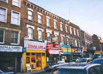
Figure 18 Shops along Stoke Newington High Street (nos. 202 – the Jolly Butcher Public House – no.
218)
Stoke Newington Conservation Area Appraisal November 200435
5 THE BUILDINGS OF THE STOKE NEWINGTON
CONSERVATION AREA
5.1 Introduction
The Stoke Newington Conservation Area contains an interesting variety of buildings
dating to the 18th, 19th and 20th centuries, many of which are listed or locally listed.
The best quality buildings are the residential houses along Stoke Newington Church
Street, some of which date back to the early or mid-18th century and are listed grade
II* (nos. 83-87). Another smaller group of listed buildings, nos. 187-191 Stoke
Newington High Street, are also listed grade II*.
Additionally, there are some well detailed mid to late-19th century terraces, especially
along Stoke Newington Church Street, which although unlisted are relatively unaltered
and which make a positive contribution to the character of the Conservation Area.
These are called “Buildings of Townscape merit” and are marked on the Townscape
Appraisal map. There are no prestigious churches or municipal buildings as these can
be found further westwards along Stoke Newington Church Street, in the Clissold Park
Conservation Area. A modestly-sized listed chapel in Abney Park Cemetery is the
only religious building.
The more important of these buildings are described in greater detail in section 6 on
“Character Areas”.
5.2 Listed buildings
There are approximately 32 listed buildings or structures within the Conservation Area,
of which seven are listed grade II*. In addition, 13 monuments in Abney Park
Cemetery are also listed, all grade II. These listed buildings can be found in small
groups, or as individual buildings, with the highest concentration in Stoke Newington
Church Street. The most important of these listed buildings were built as prestigious
houses for the gentry in the 18th century and where they are reasonably complete they
are listed grade II*. More altered examples, or those which are slightly later, are listed
grade II. There are also a number of listed public houses. These are all included in a
list at Appendix C.
Stoke Newington Conservation Area Appraisal November 200436
Figure 19 The Coach and Horses Public House no. 178 Stoke Newington High Street (grade II)
5.3 Buildings of Local Significance
There are 36 “locally” listed buildings in the Conservation Area. These are buildings
which make a contribution to the character of the Conservation Area and which
Hackney Council consider to be of local significance due to their age, architectural
detailing or because of some unusual feature. They mainly date to the 19th century
and include a wide range of buildings including churches, public houses, schools and
terraced buildings in commercial uses. Individual features, such as good quality
shopfronts are also “locally” listed. Sadly since the list was drawn up a number of
buildings have been demolished or altered beyond recognition, including the loss of a
19th century wooden post box outside the Post Office in Stoke Newington Church
Street. These are all included in a list at Appendix C.
Stoke Newington Conservation Area Appraisal November 200437
Figure 20 Nos. 1-4 Stamford Hill (locally listed)
5.4 Buildings of Townscape Merit
Apart from the listed and locally listed buildings, a large number of unlisted buildings in
the Conservation Area have been identified as “Buildings of Townscape Merit”. These
are usually well detailed examples of mainly late 19th century houses or commercial
premises which retain their original detailing. As such, they make a positive
contribution to the character and appearance of the Conservation Area, and any
proposals to alter or demolish such buildings will be strongly resisted by the Council
(see Policy EQ13 of the UDP of 1995). Together, these buildings provide the
cohesive and interesting historic townscape which is necessary to justify designation
as a Conservation Area.
Of special merit are the many examples of good quality terraced houses and shops
within the Conservation Area, particularly nos. 10-30, 42-46, 48-62, and 84-100 on the
north side of Stoke Newington Church Street, and nos. 31-37, 39-47 and 49-69 on the
south side. Other groups are much more diverse in their ages and detailing, although
still of merit.
Stoke Newington Conservation Area Appraisal November 200438
Figure 21 Summerhouse Road – Buildings of Townscape Merit
Stoke Newington Conservation Area Appraisal November 200439
6 CHARACTER AREAS
There are three character areas in the Stoke Newington Conservation Area:
• Stoke Newington High Street and Stamford Hill
• Stoke Newington Church Street
• Abney Park Cemetery
6.1 Stoke Newington High Street and Stamford Hill
Stoke Newington High Street forms part of Roman Ermine Street and as such was a
major route out of the City of London, a role it continues to play in part today. It is long
and straight, leading almost directly due north. The street is densely developed to the
south of the Conservation Area with more open space to the north around the
entrance to Abney Park Cemetery and nos. 1-33 Stamford Hill. Kynaston Gardens is
a small public garden located off an alleyway through to Dynevor Road, currently in
need of restoration and enclosed by security fencing. Trees outside no. 191 and nos.
1-33 Stamford Hill make a very important contribution to the Conservation Area.
Stoke Newington High Street is a major shopping centre, with busy traffic and
constant pedestrian activity. There are no historic street surfaces apart from some
19th century granite setts in former driveways. Street lighting is by tall, steel lanterns
with reproduction light fittings. There is a plethora of street clutter (bus shelters, street
signage, litter bins, bollards) which is all modern. Negative features include the
overflowing rubbish bins, poor quality shopfronts, and constant traffic (which creates
difficulties for pedestrians). The entrance buildings to Abney Park Cemetery, despite
a high quality landscaping scheme of a few years ago, require repair and
improvement.
Stoke Newington Conservation Area Appraisal November 200440
Figure 22 Entrance to Abney Park Cemetery, Stoke Newington High Street
East side of Stoke Newington High Street.
Along the east side of High Street is almost continuous development, punctuated by
three roads, Garnham Street, Brooke Road and New Road. Clevedon Passage and
Sanford Lane are both narrow pedestrian-only pathways which lead off High Street
and connect to Garnham Street, which wraps around the back of the properties facing
the main road. This creates rectangular blocks of development, with the properties
facing High Street having rear yards and back gardens. Unusually, nos. 188-190 sit
back from the pavement, although later ground floor shops have been inserted to the
back of the pavement.
Of the 50-odd properties, three are statutorily listed, and ten locally listed. The
buildings largely date to the early or mid-19th century. Most of them are arranged in
short, matching terraces (e.g. nos. 142-148, 158-164) and have parapets which
conceal the roofs. This creates “blocks” of buildings with an almost common height, a
noticeable characteristic of the townscape when looking along High Street. The
almost universal building material is yellow London stock brick, with painted
architectural embellishments such as windows architraves, cills, string courses, and
eaves cornices. The buildings are usually just two windows wide with two over two
timber sash windows being the normal arrangement, sometimes replaced
inappropriately in uPVC or aluminium.
Stoke Newington Conservation Area Appraisal November 200441
Every building has a ground floor shop with a variety of shopfronts of modern design.
None of them are of any merit and display the type of detailing, such as over-deep
fascias, plastic lettering, and garish colours, which is at odds with the historic
character of the area.
Figure 23 Nos. 192 (on right) – 200 Stoke Newington High Street
The most important buildings are (from north to south):
Former Board School, no. 222 (locally listed).
This is a fine, three storey building set back from the road behind an original boundary
wall with the separate entrances for “Boys” and “Girls”. Built from brown brick with red
brick dressings, it dates to c. 1870.
Nos. 218-220 (listed grade II).
A pair of early 19th century houses with unsympathetic modern shopfronts, each one
window wide, with the first floor windows retaining their six over six original sashes.
This building also has a discrete modern mansard.
The Jolly Butchers Public House, no. 202-204 (locally listed).
A well preserved public house, three storeys high and four windows wide, with a red
brick front, decorated with cast iron details, white painted corner quoins, arched
window heads, sting courses and a heavy eaves cornice with deep eaves cornice
supported on groups of outsized corbels.
Stoke Newington Conservation Area Appraisal November 200442
Nos. 180-190 (locally listed).
A group made up of two distinct terraces, nos. 188-190 and nos. 180-186. Nos. 188-
190 are early 19th century, three storeys high, and two or three windows wide. Very
simply detailed, they have a stone eaves cornice and the roofs can unusually be
glimpsed from the street behind a high parapet. Modern shopfronts are generally
badly designed although the one small shop, (no. 188a) does appear to retain some
giant corbels to the very deep fascia which are of some interest and could date to the
late 19th century.
Coach and Horses Public House, no. 178 (Listed grade II).
This is another three storey building of painted stucco, with a parapet and deep eaves
cornice. There are three windows to each of the first and second floors, with black
painted moulded architraves and hood moulds tot he first floor only. The ground floor
frontage is of a traditional design, although the fenestration to High Street appears to
be more 20th century in date.
Figure 24 Nos. 188-190 (on left) Stoke Newington High Street
Stoke Newington Conservation Area Appraisal November 200443 “London Pride”, nos. 154-156 (locally listed). This is a 1930s neo-Georgian building set back slightly from the road with a deeper ground floor shop. The stone façade contains a central, slightly canted, three light bay with decorated pilasters either side and matching pairs of windows. An outsized modillion cornice lies just below the parapet, with “Marks and Spencers” carved into it. The windows are original steel Crittalls – an unusual survival. No. 61 Leswin Street. This substantial red brick building with stone dressings was built in the late 19th century as a Fire Station in the late Victorian Gothic style and still retains the pair of entrance doors to the ground floor. Stamford Hill Only nos. 1-33 on the west side of part of Stamford Hill, to the north of the entrance to Abney Park Cemetery, are included in the Conservation Area Some of these houses are shown on the 1846 map – the others, to the south, appear to date to the 1850s. The earlier buildings (nos. 27-33 odd) are the remaining two pairs of the original development which continued northwards towards Tottenham, which were demolished to make way for the railway. Three storeys high, they are built in the Italianate villa style of the 1840s from yellow London stock bricks, with channelled stucco to the ground floor, moulded window architraves and Doric porticoes, and steps leading down to the front gardens. Heavily altered and extended, these buildings would benefit from careful restoration, including improvements to the front gardens which are adversely affected by car parking, over-flowing rubbish bins, and even a large advertising hoarding. Nos. 1-25 (odd) were built as a continuous terrace with one semi-detached pair. They are taller, with a mansard with dormers, and more decorated with attractive cast iron railings creating balconies above the Ionic porticoes. They are also built from London stock bricks, with painted window architraves and first floor balconettes to the principal rooms. These would benefit from thorough restoration. An attempt has been made to restore the railings to the front boundary, but these have been vandalised. Stoke Newington Conservation Area Appraisal November 2004
44

                          Figure 25 Nos. 23 (on left) – 29 Stamford Hill

This whole group is notable for the mature trees which create an important green row
of foliage looking northwards from the High Street.

To the south of nos. 1-33 lies the entrance to Abney Park Cemetery, a stunning piece
of neo-Egyptian architecture built in 1840 as a collaboration between William Hosking,
a relative of John Hosking, one of the nine founder-trustees, and Joseph Bonomi
Junior, the son of an architect with a special interest in Egyptian architecture. The
entrance is composed from two single storey Portland stone lodges, complete with
carved hieroglyphics which translate as “The Gates of the Abode of the Mortal Part of
Man”. In the centre are four massive gate pylons connected to the lodges by a metal
palisade.

West side of Stoke Newington High Street.

The west side of Stoke Newington High Street contains an almost continuous terrace
of good quality buildings which are listed, locally listed or have been identified as
Buildings of Townscape Merit. In contrast to the east side of the street, the buildings
are far more varied in terms of their relations ship with the street, building height, age,
design and detailing. The busy traffic junction with Church Street provides a central
focus to the commercial area, with the former Three Crowns Public House being
particularly important in views along the street.

Stoke Newington Conservation Area Appraisal                                November 2004
45
The most important buildings are:
Nos. 187-191 (listed grade II*).
Nos. 187 and 191 sit well back from the pavement with no. 189 projecting forward
between the other two. All of these buildings are now used as offices and no. 191 has
been substantially extended in the last few years. These buildings are notable for
their stone cornices, sash windows, red brick decoration, and good quality doorcases.
No. 189 has a slightly later porch and modillion eaves cornice and stone quoins.
Stone coped boundary walls, decorative cast or wrought iron railings and gates, and
tall gate piers topped by urns or ball finials confirm the previous high status of these
houses, although all three of them now require some degree of repair or restoration.
Figure 26 No. 187 Stoke Newington High Street (grade II*)
Former Three Crowns Public House (locally listed).
This is an ornate three storey building, largely unaltered, which sits on the corner of
Stoke Newington Church Street and the High Street. Dating from c.1890, it has a
corner turret topped by a small dome – an important feature in views along both
streets.
No. 157 (listed grade II).
A three storey house in a group with nos. 153-155. Late 18th century with modern
shopfront.
Stoke Newington Conservation Area Appraisal November 200446 Nos. 153-155 (locally listed). A pair of three storey possibly late 18th century houses, re-fronted in the mid-19th century, with sash windows and modern shopfronts. Rochester Castle Public House, no. 145 (listed grade II). This is a three storey building dating to c.1900, providing an eclectic mix of 17th century details with classical additions such as pedimented dormers to the mansard. Built from red brick with stone dressings, it has a shallow curved bay to the first and second floors, decorated with pargetting, and a tall gable above, facing a pierced stone parapet. The windows are mullioned and transomed, with an almost unaltered ground floor pub frontage. 6.2 Stoke Newington Church Street Church Street is notable for the variety of its mainly commercial buildings, united by their siting on or close to the back of the pavement; for the long terraces of good quality mid-19th century shops at its eastern end; and by the group of grade II* listed properties in the middle of this section of the street, facing the leafy entrance to Abney Park Cemetery. Further west, towards the parish church of St Mary’s and the 1930’s Town Hall, both of which lie in the adjoining Clissold Park Conservation Area, the street narrows and curves, and is faced by smaller scale, very mixed development, with some empty sites and modern buildings. To either side lie short residential streets, with matching terraces of late 19th century houses. These houses, along with the terraces of commercial properties along the eastern end of the street, have been assessed as being Buildings of Townscape Merit. Townsend Court replaced a chapel and its bold gabled frontage with artificial stone details reflects this precedent. This is a much quieter street than the High Street, and although still a major traffic route it does provide a much less frantic and more attractive environment than the canyon-like enclosure provided by the tall terraced houses along the High Street. Additionally, the close proximity of the Cemetery, with its mature trees, shrubbery and hidden pathways, provides a break in the dense urban character of the area. The only other trees of note are in the playground to the modern school on the north side of the street (St Mary’s Primary). Views along Church Street to the spire of St Mary’s Church, and northwards to the trees in Abney Park Cemetery, are particularly important. Stoke Newington Conservation Area Appraisal November 2004
47

        Figure 27 View westwards along Stoke Newington Church Street (nos. 97-103 on left)

South side of Church Street.

This side of the street contains almost continuous development punctuated by William
Pattern Primary School and nos. 135-137, which are set well back from the road with
a deep front garden, currently very neglected.

The most important buildings are:

William Pattern Primary School (locally listed).
A substantial late 19th century school set well back from the road behind a high brick
wall decorated with modern tiles.

Booth’s Café, nos. 71-73 (locally listed).
A pair of altered three storey villas, built from London stock brick with some original
sash windows and a modern mansard.

Nos. 75-93 (listed grade II and II*).
This is an important group as the original ground floors have survived without later
shopfronts being inserted. They date to the late 18th and early 19th centuries and are
built from brown brick, often with red brick dressings to the windows, and moulded red
brick string courses. They are three or sometimes four storeys high with parapets
hiding the roofs and stuccoed ground floors with some original front doors and

Stoke Newington Conservation Area Appraisal                                  November 2004
You can also read