STATEMENT OF C HARACTER - Athy Architectural Conservation Area Athy, Co. Kildare for Kildare County
←
→
Page content transcription
If your browser does not render page correctly, please read the page content below
for Kildare County
      Council

                     Athy Architectural Conservation Area
                     Athy, Co. Kildare
                     STATEMENT OF C HARACTER
ATHY ARCHITECTURAL CONSERVATION AREA                                                                                SEPTEMBER 2021
STATEMENT OF CHARACTER

Preface                                                            Acknowledgements
This assessment of the special character of Athy Architectural     This document includes Ordnance Survey Ireland data
Conservation Area was prepared in 2020 by Lotts Architecture       reproduced under the OSI licence number
and Urbanism Ltd. The architectural historian Dr Michael O‘Neill   2020/CCMA/KildareCountyCouncil. Unauthorised reproduction
contributed to the section on the history of the town.             infringes Ordnance Survey Ireland and Government of Ireland
                                                                   copyright.
The study was commissioned by Kildare County Council and its
progress was guided by Amy Granville, Senior Executive Planner,
David Jordan, Executive Planner and Peter Black, Architectural
Conservation Officer.

Desmond Byrne B.Arch MRIAI
Director
Lotts Architecture and Urbanism Ltd.
June 2020

lotts architecture and urbanism ltd                                                                                          1 of 91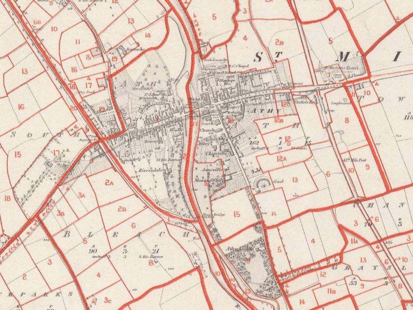
ATHY ARCHITECTURAL CONSERVATION AREA                                                                                                                                              SEPTEMBER 2021
STATEMENT OF CHARACTER

Table of Contents

1.0    Introduction................................................................................................................................................................................. 4
  1.1     Architectural Conservation Areas .................................................................................................................................................... 4
  1.2     Location and Setting of ACA........................................................................................................................................................... 5
SECTION A: Historical and Architectural Description ........................................................................................................................................... 7
2.0    Historical Development of Athy .......................................................................................................................................................... 8
  2.1     Medieval Period ......................................................................................................................................................................... 8
  2.2     Sixteenth Century ...................................................................................................................................................................... 9
  2.3     Seventeenth Century .................................................................................................................................................................. 10
  2.4     Eighteenth Century .................................................................................................................................................................... 10
  2.5     Nineteenth Century ................................................................................................................................................................... 12
  2.6     Twentieth Century .................................................................................................................................................................... 21
  2.7     Historical Sources ...................................................................................................................................................................... 24
3.0    Statutory Protection and Planning Objectives ........................................................................................................................................ 25
  3.1     Protected Structures in the ACA ..................................................................................................................................................... 25
  3.2     Recorded Monuments in the ACA .................................................................................................................................................... 27
  3.3     ACA Boundary .......................................................................................................................................................................... 28
4.0    Description of Historic Built Environment ............................................................................................................................................. 30
  4.1     Defining Characteristics .............................................................................................................................................................. 30
4.1.1          Layout ........................................................................................................................................................... 30
4.1.2          Socio-economic Functions ...................................................................................................................................... 31
4.1.3          Building Types and Scale ........................................................................................................................................ 32
4.1.4          Building Materials ............................................................................................................................................... 34
4.1.5          Quality and treatment of Open Space .......................................................................................................................... 36
  4.2     Street by street appraisal ............................................................................................................................................................ 37
4.2.1          William Street, Duke Street, Leinster Street ................................................................................................................... 37
4.2.2          Stanhope Street and Offaly Street .............................................................................................................................. 42
4.2.3          Emily Square and Barrow Quay ................................................................................................................................. 44
4.2.4          Stanhope Place and Mount Hawkins ............................................................................................................................ 47
4.2.5          Plots to rear of Main Thoroughfares ............................................................................................................................ 49
4.2.6          Area around St. Michael’s Church of Ireland church ........................................................................................................... 51
4.2.7          St. John’s Lane .................................................................................................................................................. 53
4.2.8          Woodstock Street ............................................................................................................................................... 55
4.2.9          Barrow Line of the Grand Canal and River Barrow ............................................................................................................. 57
  4.3     Views .................................................................................................................................................................................... 60
  4.4     Summary of Special Character ....................................................................................................................................................... 62
SECTION B: Guide to Development within the ACA ............................................................................................................................................ 63
5.0    Implications for Planning and Development ........................................................................................................................................... 64

lotts architecture and urbanism ltd                                                                                                                                                            2 of 91
ATHY ARCHITECTURAL CONSERVATION AREA                                                                                                                                          SEPTEMBER 2021
STATEMENT OF CHARACTER

  5.1    Planning Control ....................................................................................................................................................................... 64
5.1.1         Limits to Exempted Development .............................................................................................................................. 64
5.1.2         Protected Structures ............................................................................................................................................ 64
5.1.3         Other Non-Protected Structures ................................................................................................................................ 65
5.1.4         Public Realm .................................................................................................................................................... 65
  5.2    Works which do not affect the character of the ACA ............................................................................................................................. 65
5.2.1         Maintenance and Repairs ....................................................................................................................................... 65
5.2.2         Internal Alterations ............................................................................................................................................. 65
5.2.3         Restoration of Character ........................................................................................................................................ 66
  5.3    Works which affect the character of the ACA ..................................................................................................................................... 66
5.3.1         External Walls ................................................................................................................................................... 67
5.3.2         Windows and Doors.............................................................................................................................................. 71
5.3.3         Medieval Structures ............................................................................................................................................. 72
5.3.4         Vernacular Buildings ............................................................................................................................................ 73
5.3.5         Industrial Heritage .............................................................................................................................................. 73
5.3.6         Shopfronts ....................................................................................................................................................... 73
5.3.7         Signage and External Fittings ................................................................................................................................... 76
5.3.8         Boundary Treatments ........................................................................................................................................... 78
5.3.9         Demolition ....................................................................................................................................................... 79
5.3.10        New Build Interventions......................................................................................................................................... 80
5.3.11        Amalgamation of Properties or Sites ........................................................................................................................... 81
5.3.12        External Lighting. ............................................................................................................................................... 81
5.3.13        Views ............................................................................................................................................................ 82
5.3.14        Use of Professional Advice ...................................................................................................................................... 82
  5.4    Works to the Public Realm ........................................................................................................................................................... 83
5.4.1         Works by the Local Authority ................................................................................................................................... 83
5.4.2         Works by Statutory Undertakers ................................................................................................................................ 83
5.4.3         Historic Paving and Street Furniture ........................................................................................................................... 83
5.4.4         Drainage ......................................................................................................................................................... 84
5.4.5         Street Lighting .................................................................................................................................................. 84
5.4.6         Traffic and Management Signage ............................................................................................................................... 84
5.4.7         Management of Parking ......................................................................................................................................... 84
5.4.8         Planting and Landscaping ....................................................................................................................................... 86
5.4.9         Service Utilities ................................................................................................................................................. 88
5.4.10        Wires and Distribution Poles .................................................................................................................................... 88

lotts architecture and urbanism ltd                                                                                                                                                         3 of 91
ATHY ARCHITECTURAL CONSERVATION AREA                                                                                                     SEPTEMBER 2021
STATEMENT OF CHARACTER

                                                                                The aim of ACA designation is to preserve and enhance the character of
1.0            Introduction
                                                                                the area or group of structures. The form and arrangement of buildings,

1.1            Architectural Conservation Areas                                 structures and landscape features within an ACA are important in how
                                                                                they contribute to the character of the area or group of structures.
Planning legislation allows a planning authority to include objectives in
                                                                                Historic materials, architectural features, prevailing heights, building
its development plan / local area plan to preserve the character of
                                                                                lines and plots sizes, as well as the scale and arrangement of streets
places, areas, groups of structures, or townscapes that:
                                                                                and open spaces all contribute to the character of an ACA.
      •   are of special architectural, historical, archaeological, artistic,
                                                                                For this reason, the external appearance of buildings and the features
          cultural, scientific, social or technical interest or value, or
                                                                                of the open space are protected in an ACA. Planning permission is
      •   contribute to the appreciation of protected structures.               required for any works that would have an impact on the character of
                                                                                an ACA. Importantly, works which in other locations would meet the
Such areas, places or groups of structures are known as Architectural
                                                                                criteria for exempted development as outlined in the Planning
Conservation Areas, or ACAs.
                                                                                Regulations will require planning permission if they are within an ACA.
An ACA could be an historic town centre, a distinctive streetscape, a
                                                                                Designation as an ACA does not prevent alterations, extensions or new
terrace of houses, or it might be a wider group of structures associated
                                                                                build within the area, but aims to ensure that any new development
with a specific building such as a country house, an old mill or a canal.
                                                                                respects or enhances the special character of the ACA. Works must
In the case of Athy, many of the above categories of interest were
                                                                                therefore be carried out in consultation with the planning department
observed and their evolution over time have given rise to its special
                                                                                and architectural conservation officer, and this is usually through the
character. This document assesses that special character.
                                                                                planning process.
The document also looks at the proposed ACA boundary and, having
                                                                                This document defines the special character of the Athy ACA and gives
assessed the special character of the town, gives recommendations to
                                                                                guidance to homeowners, developers, architects and planning
include or exclude certain areas. It also identifies important views
                                                                                professionals on important features and characteristics of the area and
within, into and out of the area, even if all territory encompassed by
                                                                                the type of works that would require planning permission within the
such views is not encompassed by the ACA boundary.
                                                                                ACA.

lotts architecture and urbanism ltd                                                                                                                4 of 91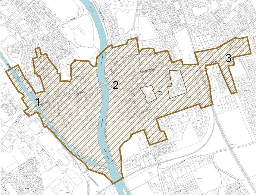
ATHY ARCHITECTURAL CONSERVATION AREA                                                                                                   SEPTEMBER 2021
STATEMENT OF CHARACTER

1.2          Location and Setting of ACA

Athy, in Irish Baile Átha Í, meaning ‘The town of the ford of Í’ is a
market town on the River Barrow located in the southwest of County
Kildare. It is located on the N78 a national primary road and lies at the
centre of a network of smaller roads linking it to its rural hinterland.
The small market town of Stradbally is located 13km to the northwest,
Kildare town lies 22km to the north and Carlow is 19km to the south.

                                                                             Fig. 2: ACA boundary from the Kildare County Development Plan 2017-2023
                                                                             The town is situated in a landscape described in the Kildare County
                                                                             Development Plan 2017- 2023 Landscape Character Assessment as
                                                                             ‘Southern Lowlands: …fertile lands with relatively high levels of local
                                                                             population and intensive land management. The slope and topography
                                                                             of areas occur in a shallow/gradual transition; the area is generally
                                                                             characterised by flat terrain and low vegetation. Concentrations of
                                                                             tillage lands in this lowland area tend to be characterised by extensive
                                                                             views across large fields with low, maintained hedges’. The underlying
Fig. 1: Extract from the historic Geological Survey map of 1858, sheet 128   geology is of limestone with a band of alluvial covering along the river
                                                                             path.

lotts architecture and urbanism ltd                                                                                                             5 of 91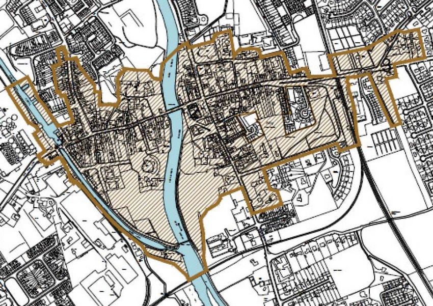
ATHY ARCHITECTURAL CONSERVATION AREA                                                                                               SEPTEMBER 2021
STATEMENT OF CHARACTER

Athy is also located on the important River Barrow corridor and Barrow    branch off this line runs south of the town and crosses the river near
Line of the Grand Canal. These have site specific relationships to the    the meeting point of the canal and river. The topography town is
larger landscape. Both waterways play an important part in the history    relatively flat with no highpoints or locations offering an overview. For
and experience of the town.                                               the most part, the town is experienced along its street spaces, river
                                                                          and canal.
Athy is arranged around the bridge crossing of the River Barrow,
guarded by White’s Castle and has two main routes organised in a
cruciform east of the river with an attractive main square at the road
crossing. The canal marks the west end of the town, it runs north south
and meets the river south of the town centre. The railway marks the
east end of the historic town and runs in a north-south direction. A

lotts architecture and urbanism ltd                                                                                                         6 of 91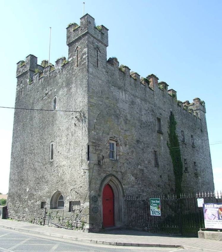
ATHY ARCHITECTURAL CONSERVATION AREA   SEPTEMBER 2021
STATEMENT OF CHARACTER

SECTION A: Historical and
Architectural Description

lotts architecture and urbanism ltd           7 of 91
ATHY ARCHITECTURAL CONSERVATION AREA                                                                                                  SEPTEMBER 2021
STATEMENT OF CHARACTER

                                                                            crossing. The Dominican Priory was on the east bank, south of the
2.0          Historical Development of Athy
                                                                            bridge, close to the present Emily Square, founded either 1253 or 1257.

2.1          Medieval Period                                                St. Michael’s Priory (Priory of St. Thomas and house of St. Michael of
                                                                            the Crutched Friars) was located on high ground on the west bank,
There is no evidence of occupation at this location before the
                                                                            founded in either the late twelfth or mid-thirteenth century.
thirteenth century. Prior to the arrival of the Anglo-Norman’s (1169-70),
                                                                            Athy was a relatively prosperous frontier town in the marches of the
Athy was part of the minor kingdom of Iarhar Lifhi, ruled by the Uí
                                                                            Pale, where in 1331 the Red Book of Kildare recorded the town as
Muircedag dynasty.
                                                                            having ten burgesses paying £23 in dues to the Earl of Kildare. It was
Anglo-Norman towns were often first settled with a motte and bailey
                                                                            subject however, to sporadic attacks, the O’Moores in 1308, during the
and when security was achieved, continued with the development of a
                                                                            Bruce invasion in 1315, and again by the O’Moore’s in 1370 and 1374.
borough – an economic and legal entity with various incentives to
                                                                            In order to secure the ninth Earl of Kildare’s active cooperation in
attract colonists to the new venture. This included being offered
                                                                            assisting the Dublin administration and the recovery of lands, Henry VIII
properties known as burgages (hence burgage plots) within the
                                                                            in 1515 approved a bill which, if passed through the Irish Parliament,
settlement area – as distinct from the rural hinterland, to settle, build
                                                                            would have conferred on him (the Earl of Kildare) all the possessions
on and from which to engage in trade. The town gave a ready market
                                                                            formerly owned by Maurice Fitzthomas, the fourth Earl (1342-90).
for trade and collective legal protection – local courts, set market days
                                                                            Henry VIII also conferred other privileges on the earl in 1515, notably a
– and provided some element of physical security to the inhabitants.
                                                                            grant of two charters for the towns of Kildare and Athy. These invested
The Anglo-Norman overlords of Athy were the de St. Michael’s, barons
                                                                            the sovereign and portreeves (town official) of both towns with the
of Narragh and Riban. The de St. Michael’s first and ultimately
                                                                            authority to determine all pleas and assizes within their respective
unsuccessful settlement was at Woodstock, 600 metres northwest of the
                                                                            jurisdictions and with the right to collect all profits and payments
fording point around which Athy would develop. Woodstock Castle dates
                                                                            arising from those cases. Both towns’ officials were to oversee the
from the thirteenth century.
                                                                            return of writs, a measure which effectively excluded the king’s sheriff
There is no documentary evidence for the foundation of medieval Athy.
                                                                            from their jurisdictions. They were also granted the power to act as
By the late thirteenth century, it was an established town with a
                                                                            justices of the peace, and to administer the offices of escheator (royal
religious foundation on either side of a stone bridge across the Barrow
                                                                            official), clerk of the town’s market and coroner. Furthermore, they
and a parish church located to the east at a distance from the river
                                                                            were permitted to levy customs which they were expected to spend on

lotts architecture and urbanism ltd                                                                                                            8 of 91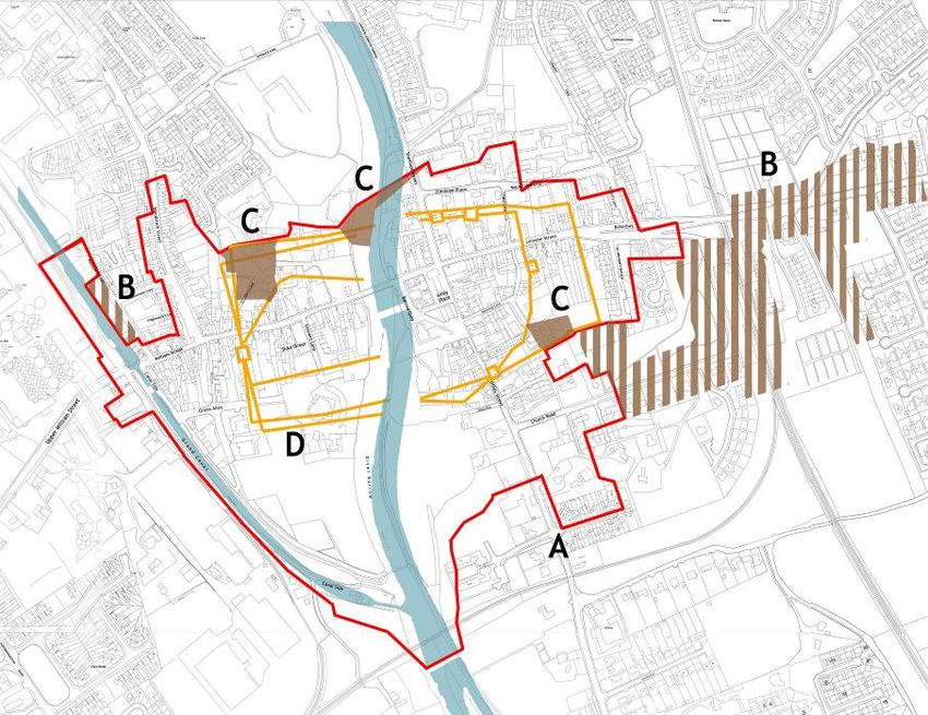
ATHY ARCHITECTURAL CONSERVATION AREA                                                                                                    SEPTEMBER 2021
STATEMENT OF CHARACTER

the walls and pavements of the towns, and they were ordered to            forces, both having been occupied by the Irish since the outbreak of
account for the levies collected to the Earl of Kildare.                  rebellion. The O’Moores razed the bridge and broke all doors, windows
                                                                          and battlements in the manor of Woodstock. The enormous amount of
                                                                          labour and supplies invested in the re-edification of the castle and
                                                                          bridge of Athy, and the manor of Woodstock (1536), after the
                                                                          suppression of the rebellion provide an indication of the lengths to
                                                                          which the Dublin administration was prepared to go in order to keep a
                                                                          foothold in the southwestern march of County Kildare. Concern for the
                                                                          fortifications included rebuilding of the town walls was also stipulated
                                                                          in a 1515 royal charter.

Fig. 3: Interpretation of the circuit of Athy town walls, Daniel Noonan

2.2           Sixteenth Century

In 1500 the eight Earl of Kildare had thoroughly repaired the castle at
Athy and thirty years later, the ninth earl garrisoned and fortified
Woodstock Castle nearby. As a result of its strategic location and its
close association with the Kildares, the town and its inhabitants
suffered considerable destruction during numerous raids in the course
of the rebellion in 1534-5.
                                                                          Fig. 4: Preston’s Gate, c.1840, by Du Noyen (courtesy of Royal Irish Academy)
Athy’s strategic importance in the 1530s was highlighted in the Dublin
government’s acute concern that the bridge in the town along with the
Earl of Kildare’s garrison at Woodstock should be recaptured by English

lotts architecture and urbanism ltd                                                                                                              9 of 91
ATHY ARCHITECTURAL CONSERVATION AREA SEPTEMBER 2021
STATEMENT OF CHARACTER
His survey of Athy west of the Barrow dates to 1768 on a more detailed
scale of 4 perches to one inch.
The defensive town wall is not evident in the survey. Like many towns
at this time, Athy no longer needed these kinds of fortifications.
Preston’s Gate to the southeast survived into the nineteenth century
(Fig. 4). Today the wall may remain embedded in later buildings and
below ground.
The manuscript town maps prepared by Rocque indicate that the road
pattern evident today was well established by the middle of the
eighteenth century. Some roads such as Church Road and the Stanhope
Place/Mount Hawkins Road were not then laid down. Street names
Fig. 5: Extract from the Down Survey map c.1655
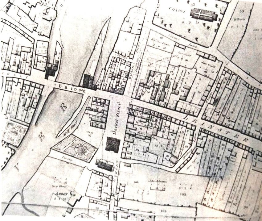
included Duke Street (St. John’s Street), Market Street (Emily Square),
Preston’s Gate (Offaly Street), High Street (Leinster Street) and Cotters
Lane (Stanhope Street). The east side of the town was better developed
2.3 Seventeenth Century
than the west, where extensive development is shown flanking the
An extract from the Down Survey Map of the Barony of Narragh and
approach roads from Stradbally and Castlecomer (Fig. 8).
Reban c.1655 shows considerable settlement on both banks of the river,
a medieval castle and stone bridge and former religious foundations
(Fig. 5). To the north is the smaller settlement of Woodstock associated
with the thirteenth-century castle.
2.4 Eighteenth Century
Moll’s map of 1714 shows the bridge in Athy to be the main crossing of
the river between Carlow and Monasterevin (O’Keefe & Simington
1991). The cartographer John Rocque surveyed Athy east of the river
Barrow in 1756 on a scale of 16 perches to one inch (Fig. 6 and Fig. 7).
lotts architecture and urbanism ltd 10 of 91ATHY ARCHITECTURAL CONSERVATION AREA SEPTEMBER 2021
STATEMENT OF CHARACTER
Fig. 6: John Rocque’s map of Athy east of the River Barrow 1756, scale 16
perches to one inch (Trinity College Dublin)
Fig. 7: Detail of John Rocque’s map of Athy east of the River Barrow 1756,
scale 16 perches to one inch (Trinity College Dublin). Note the presence of
Preston’s Gate (to right of ‘Market Street’ on sheet).
lotts architecture and urbanism ltd 11 of 91ATHY ARCHITECTURAL CONSERVATION AREA SEPTEMBER 2021
STATEMENT OF CHARACTER
Fig. 9: Extract from A Map of the County of Kildare. Lieutenant Alexander
Fig. 8: John Rocque’s map of Athy west of the River Barrow 1768, scale 4 Taylor of His Majesty’s 81st Regiment 1783
perches to one inch.
The river crossing is marked by Cromaboo Bridge, which dates from 2.5 Nineteenth Century
1796 and its classical style and harmonious symmetrical appearance is
A map of Athy (Fig. 10) was prepared in 1827 for the Duke of Leinster by
well appreciated by views up and down the river.
Clarges Greene of Dominick Street, Dublin. On a scale of 80 feet to one
Public buildings associated with an urban settlement - the Town Hall
inch the manuscript map shows the entire town on a single sheet.
which also served as Courthouse and Market House, the town jail and
Changes in local street names since Rocque’s Surveys of 1756 and 1768
the Church of Ireland and Catholic Churches are located to the east side
include:
of the river. The cavalry barracks was erected west of the river in
− St. John’s Street to Duke Street
Barrack Street early in the eighteenth century.
− High Street and Bore Buoy to Leinster Street
− Preston’s Gate to Ophaly Street (present Offaly Street)
− Cotters Lane to Kildare Street (present Stanhope Street).
lotts architecture and urbanism ltd 12 of 91ATHY ARCHITECTURAL CONSERVATION AREA SEPTEMBER 2021
STATEMENT OF CHARACTER
essence today. St. Michael’s Catholic Chapel is located prominently on
Stanhope Street close to the town centre. It enjoys a large site and is
well set back from the road. This structure was replaced in the 1960s.
Other changes reflected in the 1827 map included the removal of the
Turnpike Gate and the Turnpike House at the junction of Green Alley
and Duke Street with the subsequent realignment and widening of Duke
Street from Green Alley to a point approximately opposite St. John’s
Lane. Another road widening project, although not completed in 1827,
was also noted by Greene. The realignment of the former Cotters Lane,
now renamed Kildare Street, was to be completed before 1837,
following which it was renamed Stanhope Street.
The form of the river is worth noting; the map shows a mill race and
mill beside the bridge. Later maps indicate a substantial weir in the
river. The width of the river at this location was greater than present
day.
Lewis noted in his Topographical Dictionary of Ireland in 1837 that the
Fig. 10: Survey of the Town of Athy in the County of Kildare The Estate of His town had a population of 4,484 inhabitants and that it comprised 733
Grace Augustus Frederick Duke of Leinster by Clarges Greene 1827, Dominick
Str., Dublin. Scale: Eighty feet to an inch (56 x 82 ½). houses in 1831. He also noted the principal trade to be corn and the use
of the Grand Canal for its transport. Commercial tillage in Ireland grew
The map records the principal monuments of the town including the since the proceeding century to require mills, malt houses, breweries
Market Hall and places of worship. The Church of Ireland church is and distilleries in towns with navigable rivers.
shown on the site of the former Dominican Priory, south of the Market The major development in Athy since Rocque’s days was of course, the
Hall. The priory was destroyed in 1650 during the Confederate Wars and construction of the Barrow Line of the Grand Canal in 1791. Clearly
the structure shown in this plan was to be replaced in the 1840s by intended in its approach to Athy to cause the least disruption to the
another on a site to the south (St. Michael’s). The Methodist chapel on town’s layout, the canal skirted the town requiring the demolition of
Meeting Lane dates from the early part of the century and remains in few houses, except where it traversed the Castlecomer Road. With the
lotts architecture and urbanism ltd 13 of 91ATHY ARCHITECTURAL CONSERVATION AREA SEPTEMBER 2021
STATEMENT OF CHARACTER
construction of the canal and its numerous ancillary stores, the as yet constructed to span the line and a station with platforms lies south of
unnamed Shrewleen and Nelson Street were laid down. Another laneway the bridge.
opened up since the Rocque period and noted on Greene’s map was the The Second Edition Ordnance Survey map dates from 1907-9 (Fig. 13). It
future Stanhope Place and Mount Hawkins. In 1827, the unnamed records developments that include:
laneway connected Kildare Road with the lane (present Convent View) − St. Michael’s Church of Ireland Church located on Mount Offaly
leading from Leinster Street to Moneen Commons. Names given in Road replaced the earlier church to the north near the Market
Greene’s manuscript map for previously unnamed thoroughfares Hall. It is also visible from the river (Fig. 19)
included William Street, Meeting Lane and Chapel Lane (taking in the − Prospect Lodge house replaced the jail on Mount Offaly Road
present lane of that name and Stanhope Place). − Church Road was built to run between St. Michael’s Church of
The canal gave order to the development of the west part of Athy and Ireland Church and the railway station. A substantial L-shaped
to the south and southwest border of the town. It included a lock and park (People’s Park) with tree planting and serpentine paths is
bridge on William Street and a lock and horse bridge to the south where located on the north side of the road.
the river and canal join together. − The Model School, a manse and Presbyterian Church were added
The 1839 First Edition Ordnance Survey map gives an overview of the to the area just east of the railway bridge, replacing earlier
town and its surrounding (Fig. 11). Some items are worth noting, the structures
construction of a national school to the front of the Catholic Chapel, a − A large convent was added to the rear of St. Michael’s Catholic
jail to the southeast on Mount Offaly Road and a barracks on Woodstock Church (Fig. 18) and a school flanking the space to the church
Street to the northwest. The riverside is shown populated with a front.
number of free-standing houses with landscaped grounds; St. John’s − A free-standing courthouse southwest of the Market Hall.
House northwest of the bridge, Riversdale, Clareville, Janeville, Mount − A large school on the north side of St. John’s Lane to the west
Offaly and Athy Lodge to the south. of St. John’s House. The mill structures and mill race at the
The First Edition OS map was revised in 1872-4 (Fig. 12). Its most bridge remain.
important feature is the addition of the railway to the east between the
− Large mill and malt-house structures clustered around the canal
town and historic church and graveyard of St. Michael’s. This was
bridge to the west end of the town.
completed in 1846 as part of the Great Southern and Western Railway
− South of the town centre, St. Dominic’s Catholic Chapel, beside
network. A stone bridge and substantial approach ramps were
Riversdale House (Fig. 21), which retained its views to the river.
lotts architecture and urbanism ltd 14 of 91ATHY ARCHITECTURAL CONSERVATION AREA SEPTEMBER 2021 STATEMENT OF CHARACTER The town continued to grow around its cruciform road layout and river crossing. The growth was arranged in an informal grid of streets and blocks. The streets were defined by terraces of dwellings and shops, all in a simple and homogeneous classically influenced style (Fig. 16 and Fig. 17). The layout is punctuated by public buildings and churches situated at important viewpoints. The earlier castle retained its prominent focus at the bridge (Fig. 14 and Fig. 15). The river and canal were aligned with buildings, uncluttered quays and banks. lotts architecture and urbanism ltd 15 of 91
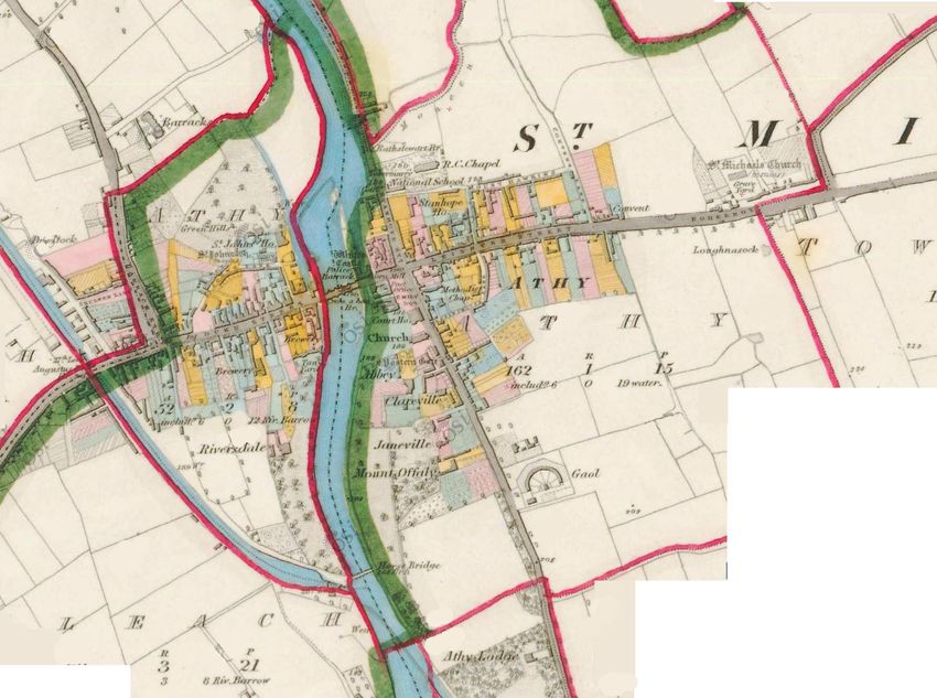
ATHY ARCHITECTURAL CONSERVATION AREA                                                                              SEPTEMBER 2021
STATEMENT OF CHARACTER

Fig. 11: Extract from first edition Ordnance Survey map of 1839 (enlarged from original scale of 6” to 1 mile).

lotts architecture and urbanism ltd                                                                                      16 of 91
ATHY ARCHITECTURAL CONSERVATION AREA                                                                   SEPTEMBER 2021
STATEMENT OF CHARACTER

Fig. 12: Extract from the Griffith Valuation map based on the Ordnance Survey map revision of 1872-4

lotts architecture and urbanism ltd                                                                           17 of 91
ATHY ARCHITECTURAL CONSERVATION AREA                                                                                 SEPTEMBER 2021
STATEMENT OF CHARACTER

Fig. 13: Extract from second edition Ordnance Survey map of 1907-9 (enlarged from original scale of 25” to 1 mile)

lotts architecture and urbanism ltd                                                                                         18 of 91
ATHY ARCHITECTURAL CONSERVATION AREA                                                                                                       SEPTEMBER 2021
STATEMENT OF CHARACTER

Fig. 14: View of White’s Castle and Cromaboo Bridge from the south c.1900,   Fig. 16: View of Market Square c.1900, Lawrence Collection (NLI)
Lawrence Collection (NLI)

Fig. 15: View of White’s Castle and Leinster Street from the east c.1900,    Fig. 17: Woodstock Street c.1900, Lawrence Collection (NLI)
Lawrence Collection (NLI)

lotts architecture and urbanism ltd                                                                                                               19 of 91
ATHY ARCHITECTURAL CONSERVATION AREA                                                                                                SEPTEMBER 2021
STATEMENT OF CHARACTER

Fig. 18: Convent of Mercy c.1900, Lawrence Collection (NLI)           Fig. 20: Duke Street c.1900, Lawrence Collection (NLI)

Fig. 19: St. Michael’s COI church c.1900, Lawrence Collection (NLI)   Fig. 21: Dominican Friary c.1900, Lawrence Collection (NLI)

lotts architecture and urbanism ltd                                                                                                        20 of 91
ATHY ARCHITECTURAL CONSERVATION AREA                                                                                                     SEPTEMBER 2021
STATEMENT OF CHARACTER

2.6           Twentieth Century

The early twentieth century witnessed modest change in the
development of Athy. The 1903 Gordon Bennett Cup car race, the first
of its kind in Britain and Ireland, passed through the town. An asbestos
cement factory opened on the west side of the canal in 1937, an
important industrial facility in the new state that also had a railway
spur and bridge connection over the river south of the town. The
factory no longer makes asbestos but manufactures roof slates. Other
small-scale industries as well as shops and supermarkets made up the
economic life of the town and it continued to be a busy service centre
for the surrounding region.

                                                                           Fig. 23: Aerial view of asbestos cement factory (courtesy of UCD Digital Archive)

                                                                           The post-war period saw many changes to the town, including:

                                                                               −   Extensive areas of low-density suburban housing to the north,
                                                                                   east and south (Fig. 27)
                                                                               −   Additional industrial and commercial buildings on land west of
                                                                                   the canal
                                                                               −   Construction of large Catholic churches of St. Michael’s on
                                                                                   Stanhope Street and St. Dominic’s on Convent lane (now a
                                                                                   library), in the early 1960s
                                                                               −   Construction of recent large educational facilities at Ard na
Fig. 22: Aerial view of Athy, 1947 (courtesy of Historic England)
                                                                                   Tríonóide on Lower St. Joseph Terrace and Athy College to the
                                                                                   north of the town

lotts architecture and urbanism ltd                                                                                                                21 of 91
ATHY ARCHITECTURAL CONSERVATION AREA SEPTEMBER 2021
STATEMENT OF CHARACTER
− The Grove Cinema on Leinster Street (since demolished),
another on Offaly Street and dance hall on the Castlecomer
Road (now a community hall)
− Large supermarkets in the centre and periphery of the town
Like many other towns the main streets and public spaces today are
clogged with traffic and parking. A ring road diversion is planned to run
south of the town centre. The river and canal now serve as attractive
walks for locals and visitors.
Fig. 25: Grove cinema, established 1957, no longer extant
Fig. 26: Former cinema on Offaly Street
Fig. 24: Construction of St. Dominic’s church, 1961 (courtesy of the NLI)
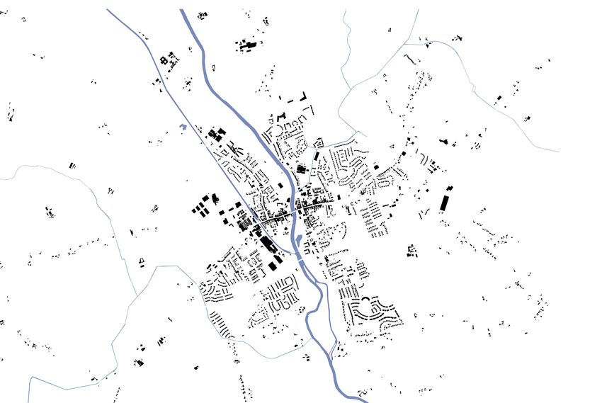
lotts architecture and urbanism ltd 22 of 91ATHY ARCHITECTURAL CONSERVATION AREA SEPTEMBER 2021 STATEMENT OF CHARACTER Fig. 27: Contemporary figure-ground map of Athy (Kildare County Council) lotts architecture and urbanism ltd 23 of 91
ATHY ARCHITECTURAL CONSERVATION AREA                                                                              SEPTEMBER 2021
STATEMENT OF CHARACTER

2.7           Historical Sources
                                                                               Websites:
−      ‘An Introduction to the Architectural Heritage of County Kildare’,      www.buildingsofireland.ie
      (Department of the Environment and Local Government 2002)
                                                                               www.osi.ie
−     Allan, F.H.A et al, eds, ‘Atlas of the Irish Rural Landscape’, (Cork
      2011)                                                                    www.griffiths.askaboutireland.ie

−     Duffy, Patrick J., ‘The Territorial Identity of Kildare’s Landscapes’,
      in William Nolan and Thomas McGrath, Kildare History & Society
      (Dublin, 2006), pp1-34.
−     Gwynn, Aubrey & Hadcock, R.N., Medieval Religious Houses Ireland
      (Dublin, 1970)
−     Hill, Simon et al., Conservation, Management and Interpretation
      Plan for Athy, Co Kildare (4 November 2016)
      http://kildareheritage.com/wp-content/uploads/2016/06/Athy-
      Conservation-Managment-Interperation-Plan-commissioned-2016.pdf
−     Lyons, Mary Ann, Church and Society in County Kildare c.1470-1547
      (Dublin, 2000)
−     Nolan, William and McGrath, Thomas, Kildare History & Society
      (Dublin, 2006)
−     O’Keeffe, Peter & Simington, Tom, ‘Irish Stone Bridges, History and
      Heritage’, (Newbridge 1991)
−     Taffe, Frank, http://athyeyeonthepast.blogspot.ie/1998/12/athy-
      in-maps-1.html
−     Thomas, Avril, The Walled Towns of Ireland (2 Vols.) (Dublin, 1992)

lotts architecture and urbanism ltd                                                                                      24 of 91
ATHY ARCHITECTURAL CONSERVATION AREA SEPTEMBER 2021
STATEMENT OF CHARACTER
AY032 The Emigrant, Barrow Quay
3.0 Statutory Protection and Planning Objectives
AY033 Bapty Maher’s, Leinster Street
In addition to the protection afforded by the ACA designation, some AY034 Rafter’s, 25 Leinster Street
individual structures within the ACA are protected by other statutory AY035 Manleys, 25 Leinster Street
designations. AY036 46 Leinster Street
AY037 Athy Community Centre, Stanhope Street
3.1 Protected Structures in the ACA
AY038 Carlton Hotel, former convent, Stanhope Place
The structures listed below, which lie within the boundary of the AY040 Carlton Hotel, former convent, Stanhope Place
existing Architectural Conservation Area are included in the Kildare AY041 Carlton Hotel, former convent, Stanhope Place
County Council Record of Protected Structures (RPS), in the County AY042 St. Michael’s Catholic Church, Stanhope Street
Development Plan 2017-2023. AY043 Bridge, Rathstewart Road
AY046 St. John’s Cemetery, St. John’s Lane
In addition to the protection conferred by the ACA, these structures and
AY048 Wall, St. John’s Lane
their attendant grounds, known as their curtilage, are protected in their
AY049 McLaughlin’s Bar, 9 Leinster Street
own right under Part IV of the Planning and Development Act 2000.
AY050 82 Leinster Street
AY001 St. Michael’s Cemetery, Boherboy
AY051 69 Leinster Street
AY017 The Grand Canal
AY053 Meeting Lane
AY020 Cromaboo Bridge
AY054 20 Leinster Street
AY021 The White Castle, Leinster Street
AY055 21 Leinster Street
AY022 Fountain, Emily Square
AY057 Post Box, 69 Leinster Street
AY023 5 Emily Square
AY058 67 Leinster Street
AY024 W. T. Duthie, 30 Leinster Street
AY059 6 Leinster Street
AY025 31 Leinster Street
AY060 5 Leinster Street
AY026 Bank of Ireland, Emily Square
AY061 11 Leinster Street
AY027 O’Brien’s, Emily Square
AY062 12 Leinster Street
AY030 Stanhope Place
AY063 Athy Railway Station, Church Road
lotts architecture and urbanism ltd 25 of 91ATHY ARCHITECTURAL CONSERVATION AREA SEPTEMBER 2021 STATEMENT OF CHARACTER AY064 Athy Railway Station, Church Road – Post Box AY103 24-25 Duke Street AY065 Athy Railway Station, Church Road – Water Tower AY104 43 Duke Street AY066 Athy Railway, Church Road – Bridge AY105 44 Duke Street AY067 Trough, Leinster Street AY107 The Rectory, Church Road AY075 Athy Town Hall, Emily Square AY108 The Rectory, Church Road AY077 Athy Court House, Emily Square AY109 Chruch Road AY079 22 Griffin Hawe AY110 Athy Lodge, Church Road AY080 Griffin Hawe, Duke Street AY111 Teach Iosa, Carlow Lodge AY081 Athy Post Office, Duke Street AY112 St. Michael’s COI AY083 Janeville Cottage AY113 Post Box, Offaly Street AY084 Casa Maria, Janeville AY115 Prospect House, Carlow Road AY085 Offaly House, Janeville AY116 Prospect House, Carlow Road AY086 8 Offaly Street AY120 St. Anne’s B&B, Church Road AY087 7 Offaly Street AY122 3 Emily Square AY088 6 Offaly Street AY123 6 Emily Square AY089 5 Offaly Street AY124 The Immigrant AY090 4 Offaly Street AY125 Athy Presbyterian Church, Dublin Road AY091 13 Emily Square, rear AY126 The Manse, Boherboy AY094 13 Emily Square AY127 The Model Farm, Dublin Road AY095 Barrow Quay AY128 Model Court, Geraldine Road AY096 3 Duke Street AY129 Model Court, Geraldine Road AY097 5 Duke Street AY130 Model Court, Geraldine Road AY099 1 Duke Street AY131 Model Court – Youth Reach, Geraldine Road AY100 16-17 Duke Street AY132 Model Court, Montessori School AY101 14 Duke Street AY133 The Model School, Dublin Road AY102 23 Duke Street AY137 Bollards, Grand Canal lotts architecture and urbanism ltd 26 of 91
ATHY ARCHITECTURAL CONSERVATION AREA                                                                                 SEPTEMBER 2021
STATEMENT OF CHARACTER

AY138           Dry dock, Grand Canal                      AY189           Former Maltings Nelson Street
AY139           W.Doyle, Woodstock Street                  AY190           Lamp post, Cromaboo Bridge
AY140           Methodist Church, Woodstock Street         AY192           20 Emily Square
AY141           7 Woodstock Street                         AY193           18 Emily Square
AY142           8 Woodstock Street                         AY195           18 William Street
AY143           9 Woodstock Street
AY144           10 Woodstock Street
                                                           3.2         Recorded Monuments in the ACA
AY145           Post Box, Woodstock Street
AY146           39 Duke Street                             The following archaeological sites, features and artefacts within the

AY150           Bollards, Grand Canal                      Athy ACA are listed in the Record of Monuments and Places (RMP) as

AY151           Minch Norton & Co., Upper William Street   Recorded Monuments and are thereby protected under the National

AY153           15 William Street                          Monuments Acts of 1930 to 2004:

AY154           Canal lock crane, William Street           RMP No KD035-022002               Town Defences
AY155           Canal lock, William Street                 RMP No KD035-022004               Religious house
AY156           Augustus Bridge, William Street            RMP No KD035-022006               Religious house
AY157           97 Woodstock Street                        RMP No KD035-022008               Bridge
AY158           98 Woodstock Street                        RMP No KD035-022010               Castle
AY159           99 Woodstock Street                        RMP No KD035-022016               Grave slab
AY160           100 Woodstock Street                       RMP No KD035-022018               Crucifixion plaque
AY165           Post box, William Street                   RMP No KD035-022019               Architectural feature
AY167           27 Duke Street                             RMP No KD035-022020               Grave slab
AY168           26 Duke Street                             RMP No KD035-022023               Memorial stone
AY169           1 Woodstock Street                         RMP No KD035-022024               Armorial plaque
AY170           2 Woodstock Street
AY172           Convent Lane gates
AY173           Horse bridge and lock

lotts architecture and urbanism ltd                                                                                          27 of 91
ATHY ARCHITECTURAL CONSERVATION AREA SEPTEMBER 2021
STATEMENT OF CHARACTER
3.3 ACA Boundary
Following the study of the history and special character of Athy, an
assessment was made of the original ACA boundary (Fig. 28) with the
following recommendations:
− Remove areas (‘B’ in Fig. 29), that are beyond the historic core
and already enjoy protected status (i.e. areas within the
curtilage of protected structures) or have been recently
developed
− Include areas (‘C’ in Fig. 29), that are the probable location of
the historic wall fortifications and may contain remains above
and below ground
lotts architecture and urbanism ltd 28 of 91ATHY ARCHITECTURAL CONSERVATION AREA SEPTEMBER 2021
STATEMENT OF CHARACTER
Fig. 28: Athy ACA map in Kildare County Development Plan 2017 – 2023, the Fig. 29: Amended ACA boundary
numbers 1,2,3 represent character sub-areas. A: Revised boundary in red
B: Areas to be removed from proposed ACA
C: Areas to be included in the proposed ACA
D: Probable location of historic wall fortifications (see also Fig. 3)
lotts architecture and urbanism ltd 29 of 91ATHY ARCHITECTURAL CONSERVATION AREA SEPTEMBER 2021
STATEMENT OF CHARACTER
4.1.1 Layout
4.0 Description of Historic Built Environment
Athy is arranged around a main cruciform road layout, the east-west
arm crosses the River Barrow and the north-south route runs parallel to
4.1 Defining Characteristics the river. The road intersection is marked by a formal public space at
The special character of the Athy ACA can be defined under the Emily Square, just south of the crossing. The streets have a gentle
following distinctive attributes: meander to their layout, views are closed to give an intimate sense of
place.
− Layout
− Socio-economic functions The river follows a gently meandering route and buildings are set well
back, the exception to this is around the bridge, where White Castle is
− Building types, scale and materials
located, one of the main features of Athy. The river has a strong spatial
− Quality and treatment of open spaces
and visual presence, and this is one of the defining characteristics of
the town.
The Barrow Line of the Grand Canal marks the west boundary of Athy
and is flanked on the west by a band of industrial sites. The east
boundary of the town is marked by the railway line that runs parallel to
the river and main north south street axis. This boundary is further
marked by the presence of St. Michael’s Old Cemetery, St. Michael’s
New Cemetery and the People’s Park. To the north and south there are
less well-defined general boundaries to the town, historically it petered
out in an irregular manner in these directions.
The canal and river join together south of the town and form a large
triangular area south of Duke Street. This is well-defined by buildings to
the north and few structures to the south, where it has a rural
Fig. 30: Aerial view of Athy, 1947 (courtesy of Historic England) character. Otherwise the sectors between the main street axes are built
up with roads and laneways branching off the main arms:
lotts architecture and urbanism ltd 30 of 91ATHY ARCHITECTURAL CONSERVATION AREA SEPTEMBER 2021
STATEMENT OF CHARACTER
− To the northwest the layout is arranged around Woodstock − Emily Square and Athy Town Hall
Street with minor roads and lanes branching either side. The − White Castle
scale is generous, the street widens to the south and has the − St. Michael’s Church of Ireland church
character of a public square. − St. Michael’s Catholic Church
− To the northeast the informal orthogonal pattern is defined by − Woodstock Street (south end)
Leinster Street, Stanhope Place/Mount Hawkins, Stanhope − Methodist Chapel (Woodstock Street)
Street, Chapel Lane and Kirwan’s Lane. The river setting is punctuated by the following public structures:
− To the southeast the orthogonal pattern repeats and is defined − White Castle and Cromaboo Bridge
by Leinster Street, Offaly Street, Church Road, Beech Grove, − Athy Courthouse
Butler’s Lane and Meeting Lane − St. Dominic’s Catholic Church (former)
− Horse bridge
Today the medieval wall defences are no longer visible above ground
but they probably follow the orthogonal layout that remains today (see
4.1.2 Socio-economic Functions
Fig. 3).
Athy provides a centre of employment as well as commercial,
The subdivision of the areas off the main axes is composed of long
administrative and other services to its population and to the
narrow parcels known as ‘burgage plots’. This type of site division
surrounding rural hinterland. The town no longer hosts a town hall at
survives to a good extent in Athy and is one of its defining
Emily Square, a recent structure on Stanhope Street provides the
characteristics. The architecture of the principal streets is marked for
administrative offices for the Athy Municipal District.
the most part by domestic and commercial architecture, most of the
commercial activity located on the east-west axis (William Street, Duke Uses associated with Athy’s role as an industrial and traditional market
Street and Leinster Street). town contribute to its historic architectural character. It once had a
number of malt houses located on the canal and these were augmented
The topographical setting of Athy is largely flat and the stuctures and
by large factories in the twentieth century. Historic industrial
spaces have a strong presence in the layout of the town and its river
infrastructure consisting of mill houses at Cromaboo Bridge, mill races,
setting. The orthogonal layout is punctuated by the following public
sluices and weirs along the river are no longer extant. The recent
structures and spaces:
lotts architecture and urbanism ltd 31 of 91ATHY ARCHITECTURAL CONSERVATION AREA SEPTEMBER 2021
STATEMENT OF CHARACTER
disappearance of these facilities has resulted in a loss of spatial Shops were traditionally small and were located on the main
definition to the areas northeast of the bridge. thoroughfare. Some retain outbuildings to the rear, and these are
reached through covered openings from the street.
The town had some police and prison infrastructure in the nineteenth
and first half of the twentieth centuries, largely on the outskirts, but Recent educational facilities have been developed to the north of the
most of this is no longer extant. Its judicial importance is evident in the town centre (Athy College, Athy Model School, Scoil Phádraig Naofa,
fine former courthouse on Barrow Quay and previously at Emily Square. Ardscoil na Trionoide). Athy Hospital is located on the site of a former
Union Workhouse northeast of the town. Supermarket outlets are
Athy is the location of several historic and recent educational facilities
located north of the town (Aldi) and west of the railway bridge (Lidl),
serving the town and surrounding area, however, convents associated
otherwise few major retail facilities are located outside the ACA.
with St. Michael’s and St. Dominic’s Catholic churches are no longer
operating.
Over the latter half of the twentieth century the trend was for traders
and professionals to move away from the town centre, as happened in 4.1.3 Building Types and Scale
most other Irish market towns. Residential use is no longer an important The quality of the historic building stock in the Athy ACA reflect its
component of the ACA, most residential houses in the ACA are located historic, architectural and social heritage and give form to its
to the northeast on Woodstock Street or near the People’s Park to the architectural character.
southeast. Most of the town population now lives outside the immediate
The street architecture of the town follows a clear hierarchy. The
core in extensive areas of low-density suburbs. Buildings in the town on
relatively narrow east-west streets are the primary artery and it is lined
the main streets have commercial units on the ground floor. The floors
with two- and three-storey buildings, predominantly three-storey
above were once used for accommodation associated with the
towards the centre. All are arranged in orderly rows with a consistent
businesses. These are now largely in use as storage or offices. Most
building line and varying architectural expression, generally rendered
structures retain separate street entrances for the upper floors and it is
and having vertical window openings with shopfronts or decorative door
important to retain these to preserve the architectural character of the
cases at ground level. The street frontage is modulated by arched and
town.
gated openings giving access to the rear as well as narrow access lanes
interrupting the terrace line.
lotts architecture and urbanism ltd 32 of 91ATHY ARCHITECTURAL CONSERVATION AREA SEPTEMBER 2021
STATEMENT OF CHARACTER
Commercial buildings which intersperse the streetscape are marked by canal-lock infrastructure, office building and single-storey
more conscious design in their expression, scale, detailing and choice of terrace dwellings
materials. This homogenous arrangement is seldom interrupted, − The collection of structures north of St. John’s Lane that
exceptions being the former bank structure on the north side of Leinster include a former ‘Christian School’, St. John’s house, St. John’s
Street and bank building on the east side of Emily Square. manor and graveyard
The north-south main artery is shorter than the east-west artery and − Large dwelling houses on Church Road and Offaly Road, near
has a similar arrangement of three-storey buildings extending from the St. Michael’s Church of Ireland church. These impressive free-
main crossing dropping to two storeys. Emily Square has a continuous standing structures with landscaped grounds include Janeville
three-storey terrace to the west and a mix of heights to the buildings on House, Mount Offaly (Teach Iosa), Athy Lodge, The Rectory and
the east side. Offaly Street mirrors the situation on Stanhope Street nearby Gate Lodge
with a two-storey terrace to either side that raises to three storeys Building types of note for themselves include St. Dominic’s Catholic
nearing Emily Square. church on Convent Lane, the former courthouse building on Barrow
Woodstock Street is lined with rows of two-storey structures that do not Quay and the concrete tower of the former asbestos factory that lies
form a continuous terrace. They are a picturesque mix of sizes and beyond the ACA to the west.
detail embellishment. The south end of the street broadens to have an Most of the prominent public buildings in the town are free-standing
elegant and urban expression in contrast to the narrow main east-west and very visible in the public realm. This is a defining characteristic of
corridor. public buildings in Athy.
The side streets and lanes branching off the main streets have less
homogenous arrangement of buildings.
Other character areas with different historic functions and resulting
architectural expression include:
− The former convent and schools to the east of St. Michael’s
Catholic Church on Stanhope Place
− The area around the intersection of William Street and the
Barrow Line Canal with its mix of historic malt and storehouses,
lotts architecture and urbanism ltd 33 of 91You can also read