Bear Valley Community Plan - Adopted March 13, 2007 Effective April 12, 2007
←
→
Page content transcription
If your browser does not render page correctly, please read the page content below
Bear Valley
Community Plan

 Adopted March 13, 2007
 Effective April 12, 2007
Acknowledgements
    The following individuals contributed to preparation of the
                   Bear Valley Community Plan

                     Board of Supervisors
                  Brad Mitzelfelt, First District
             Paul Biane, Second District, Chairman
               Dennis Hansberger, Third District
           Gary Ovitt, Fourth District, Vice Chairman
                 Josie Gonzales, Fifth District

                 Planning Commissioners
                Ken Anderson, First District
               Michael Cramer, Second District
                 Bill Collazo, Third District
         Mark Dowling, Vice Chairman, Fourth District
            Audrey Mathews, Chair, Fifth District

              General Plan Advisory Committee
                    Mark Bulot, Redlands
                Ted Dutton, Lake Arrowhead
                    Scott Frier, Helendale
                    Matt Jordan, Redlands
                 Michael Kreeger, Chino Hills
                   Jornal K. Miller, Muscoy
                 Ken Morrison, Yucca Valley
                  Kathy Murphy, Fawnskin
                    Mark Nuaimi, Fontana
                Marvin Shaw, Lake Arrowhead
                Doug Shumway, Apple Valley
                 Jean Stanton, Bloomington
                   Eric Swanson, Hesperia

           Bear Valley Community Plan Committee
             Don Brenner          Bob Henrich
              Bob Colvin          Todd Murphy
              Chris Elder         Kathy Murphy
             Scott Eliason       Denise Proffer
            Fred Goldsmith         Sandy Steers
            Sheila Hamilton      Brent Tragaskis
               Liz Harris

2                                                                 April 12, 2007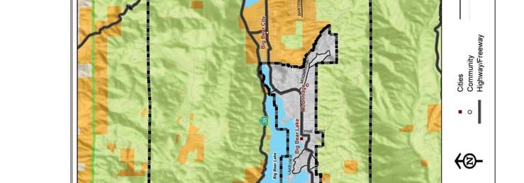
County Staff
                        Julie Rynerson Rock, AICP, Director, Land Use Services Department
                               Randy Scott, AICP, Deputy Director, Advance Planning
                                       Jim Squire, AICP, Supervising Planner
                                      Carrie Hyke, AICP, Supervising Planner
                                    Dave Prusch, AICP, Senior Associate Planner
                                       Ron Matyas, Senior Associate Planner
                                    Matt Slowik, REHS, Senior Associate Planner

                                            Consultants to the County

                                                 URS Corporation
     Frank Wein, DPDS, FAICP, Project Director                     Veronica Seyde, Senior Scientist
      Jeff Rice, AICP, Assistant Project Manager                    Tom Herzog, Senior Biologist
     Brian Smith, AICP, Environmental Manager                     Bryon Bass, Senior Archaeologist
   Kavita Mehta, Urban and Environmental Planner              Paul Nguyen, Senior Air Quality Scientist
        Cynthia Wilson, Environmental Planner                  Chris Goetz, Senior Project Geologist
     Mari Piantka, Senior Environmental Planner                  Jerry Zimmerle, Principal Engineer
Michael Greene, INCE Bd. Cert., Senior Project Scientist              Joe Devoy, GIS Specialist
        Joseph Czech, Senior Project Engineer                         Matt Eimers, GIS Analyst
     Jun Wang, Senior Water Resources Engineer                        Vidas Sekas, GIS Analyst
          Cynthia Gabaldon, Senior Engineer                       Wendy Lamont, Word Processor
                                                               Wayne Lim, Senior Graphic Designer

                                               Hogle-Ireland, Inc.
                                               Paul Ireland, Partner
                                           Mike Thiele, AICP, Principal
                                          Kimiko Lizardi, Project Manager
                                               Ron Pflugrath, AICP

                                               Jacobson and Wack
                                          Bruce Jacobson, AICP, Principal

                                                 RBF Consulting
                                               Laura Stearns, Planner

                                      Stanley R. Hoffman Associates, Inc.
                                      Stanley R. Hoffman, FAICP, President
                                    Debbie L. Lawrence, AICP, Project Manager
                                         Bravishwar Mallavarapu, Planner

                                                 ISMS, Inc.
                                           Doug Mende, Vice President

                                             Economics Politics, Inc.
                                            John Husing, Vice President

     April 12, 2007                                                                                       3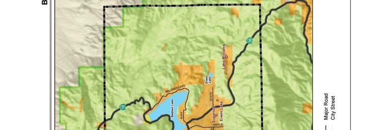
Meyer, Mohaddes Associates
                  Viggen Davidian, P.E, Project Manager
           Matthew Simons, T.E., Senior Transportation Engineer
                     Adolfo Ozaeta, Project Engineer
                      Yim Tse, Graphics Technician

                               Psomas
                   Dan McCroskey, PLS, Project Manager
                           Duane Haselfeld
                            Sergio Sanchez

                   Moore, Iacofano & Goltzman (MIG)
                     Pat McLaughlin, Office Manager
                    Esmeralda Garcia, Project Associate

                         Special Acknowledgements
    Bill Postmus, Past First District Supervisor and Chairman of the Board
     Theresa Kwappenberg, Past Third District Planning Commissioner
    Michael E. Hays, AICP, Past Director, Land Use Services Department
               Sam Gennawey, Past Project Manager for MIG

4                                                                            April 12, 2007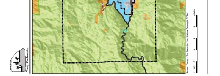
TABLE OF CONTENTS

                                                    TABLE OF CONTENTS
1 INTRODUCTION......................................................................................................................................................................... 7
   BV1.1       PURPOSE OF THE COMMUNITY PLAN .................................................................................................................... 7
   BV1.2        COMMUNITY BACKGROUND.................................................................................................................................... 7
     BV1.2.1 Location.................................................................................................................................................................. 7
     BV1.2.2 History .................................................................................................................................................................... 7
     BV1.2.3 Description of the Study Area........................................................................................................................... 11
   BV1.3       COMMUNITY CHARACTER ....................................................................................................................................... 12
     BV1.3.1 Unique Characteristics ........................................................................................................................................ 12
     BV1.3.2 Issues and Concerns ........................................................................................................................................... 12
     BV1.3.3 Community Priorities.......................................................................................................................................... 13
2 LAND USE.................................................................................................................................................................................... 15
   BV2.1       INTRODUCTION ........................................................................................................................................................ 15
   BV2.2 GOALS AND POLICIES ...................................................................................................................................................... 22
3 CIRCULATION AND INFRASTRUCTURE ........................................................................................................................ 25
   BV3.1 CIRCULATION – INTRODUCTION ................................................................................................................................... 25
   BV3.2 CIRCULATION – GOALS AND POLICIES ......................................................................................................................... 33
   BV3.3 INFRASTRUCTURE - INTRODUCTION ............................................................................................................................. 38
   BV3.4 INFRASTRUCTURE – GOALS AND POLICIES .................................................................................................................. 46
4 HOUSING ..................................................................................................................................................................................... 49
5 CONSERVATION....................................................................................................................................................................... 51
   BV5.1 INTRODUCTION ................................................................................................................................................................ 51
   BV5.2 GOALS AND POLICIES ...................................................................................................................................................... 51
6 OPEN SPACE............................................................................................................................................................................... 55
   BV/OS 6.1 INTRODUCTION ....................................................................................................................................................... 55
   BV/OS 6.2 GOALS AND POLICIES .............................................................................................................................................. 61
7 NOISE ............................................................................................................................................................................................ 65
8 SAFETY ......................................................................................................................................................................................... 67
   BV8.1 INTRODUCTION ................................................................................................................................................................ 67
   BV8.2 GOALS AND POLICIES ....................................................................................................................................................... 76
9 ECONOMIC DEVELOPMENT .............................................................................................................................................. 77
   BV9.1 INTRODUCTION ................................................................................................................................................................ 77
   BV9.2 GOALS AND POLICIES ....................................................................................................................................................... 77
10 IMPLEMENTATION............................................................................................................................................................... 79

April 12, 2007                                                                                                                                                                                       5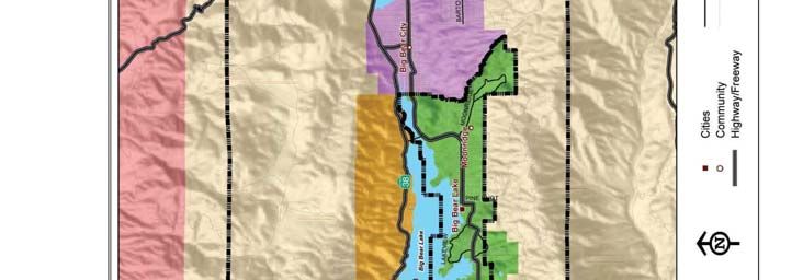
TABLE OF CONTENTS
LIST OF FIGURES
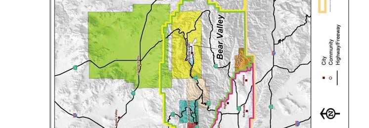
FIGURE 1-1, VICINITY/REGIONAL CONTEXT ................................................................................................................. 9
FIGURE 2-1, LAND USE POLICY ............................................................................................................................................ 17
FIGURE 3-1, CIRCULATION ..................................................................................................................................................... 27
FIGURE 3-2, WATER DISTRICTS............................................................................................................................................. 39
FIGURE 3-3, WASTEWATER SYSTEM ................................................................................................................................... 43
FIGURE 6-1, JURISDICTIONAL CONTROL......................................................................................................................... 57
FIGURE 6-2, TRAILS..................................................................................................................................................................... 59
FIGURE 8-1, FIRE DISTRICTS .................................................................................................................................................. 69
FIGURE 8-2, FIRE STATIONS ................................................................................................................................................... 74
LIST OF TABLES
TABLE 1: DISTRIBUTION OF GENERAL PLAN LAND USE DISTRICTS ................................................................. 19
TABLE 2: LAND USE POLICY MAXIMUM POTENTIAL BUILD-OUT...................................................................... 20
TABLE 3: POPULATION, HOUSEHOLDS AND EMPLOYMENT PROJECTION 2000-2030................................. 21
TABLE 4: EXISTING AND FUTURE ROADWAY OPERATING CONDITIONS..................................................... 31
TABLE 5: CMP FACILITY LEVELS OF SERVICE ............................................................................................................... 32
TABLE 6: SUPPLY AND POLICY INFORMATION OF SERVICE PROVIDERS ....................................................... 41
TABLE 7: WASTE WATER AGENCIES/DISTRICTS.......................................................................................................... 45
TABLE 8: FIRE STATIONS ......................................................................................................................................................... 71
6 April 12, 2007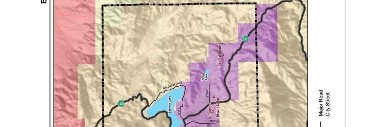
INTRODUCTION

                                  1 INTRODUCTION
BV1.1            PURPOSE OF THE COMMUNITY PLAN
The primary purpose of the Bear Valley Community Plan is to guide the future use and development of land
within the Bear Valley Community Plan area in a manner that preserves the character and independent
identity of the individual communities within the area. By setting goals and policies for the Bear Valley
Community that are distinct from those applied countywide, the community plan outlines how the County of
San Bernardino will manage and address growth while retaining the attributes that make Bear Valley unique.

Community plans focus on a particular community within the overall area covered by the General Plan of a
jurisdiction. As an integral part of the overall General Plan, a community plan must be consistent with the
General Plan. To facilitate consistency, the Bear Valley Community Plan builds upon the goals and policies of
each element of the General Plan. However, to avoid repetition, those goals and policies defined within the
overall General Plan that adequately address the conditions of the community will not be repeated in this or
other community plans. Instead, the policies that are included within the community plan should be regarded
as refinements of broader General Plan goals and policies that have been customized to meet the specific
needs or unique circumstances within individual communities.

BV1.2            COMMUNITY BACKGROUND

BV1.2.1          LOCATION
The Bear Valley Community Plan area includes approximately 135 square miles of unincorporated area
surrounding the City of Big Bear Lake. The plan area is located in the San Bernardino Mountains and is
entirely surrounded by the San Bernardino National Forest. The plan area includes the communities of
Baldwin Lake, Big Bear City, Erwin Lake, Fawnskin, Lake Williams, a portion of Moonridge and Sugarloaf
(see Figure 1-1, Vicinity/Regional Context).

BV1.2.2          HISTORY
The history of the Bear Valley area is not unlike other turn-of-the-century mountain mining settlements that
have turned to recreation and tourism to sustain them.

In 1860, the discovery of gold in the area generated a flurry of mining activity; which in turn generated a need
for timber. As a result, logging and sawmills also became a major activity in the area during this period. As the
mines were being exhausted, livestock and cattle grazing activities began to flourish. Peak mountain cattle
ranching lasted from about 1880 until the 1940’s, concentrated primarily in the Bear Valley area. The
Southern Pacific Railroad arrived in southern California in 1876 and the area began to grow rapidly. People
looked to the mountains for additional water resources for their new agricultural communities. In 1883, Frank
E. Brown organized the Bear Valley Land and Water Company, purchased land and in 1884, built the first
dam in the area.

The new mountain lake created by the 1884 dam began to attract recreational interests. In 1911, the present
day multiple-arch dam, which tripled the capacity of the lake, was constructed. By 1915, the “101 Mile Rim of
the World” highway was completed, and with the development of capable automobiles, the number of resorts

April 12, 2007                                                                                                 7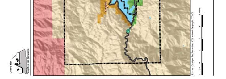
INTRODUCTION

    [This page intentionally left blank]

8                                               April 12, 2007
INTRODUCTION

                 Figure 1-1, Vicinity/Regional Context

April 12, 2007                                           9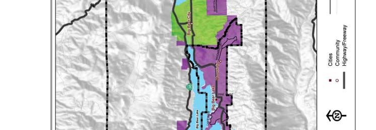
INTRODUCTION

     [This page intentionally left blank]

10                                               April 12, 2007
INTRODUCTION in the area continually increased. By the 1920s the area rapidly became resort oriented and recreation replaced ranching and mining as the predominant economic stimulus for the area. In 1934, the Big Bear Sports District was formed to develop winter sports in the area and the first ski lift (known as Lynn Lift) was constructed in 1949. By 1952, three additional ski areas were developed in Big Bear: Rebel Ridge, Goldmine and Snow Summit. Two ski areas remain in operation today, Bear Mountain and Snow Summit. The third ski area previously operated under special use permit on the San Bernardino National Forest, is no longer in operation and lands are currently being rehabilitated. The original Bear Valley Community Plan was adopted in December, 1988. The plan was intended as a short range plan to implement those portions of the General Plan that directly affected the community of Bear Valley. The 1989 General Plan update proposed that comprehensive community plans be incorporated into the General Plan and Development Code, however, full incorporation was not completed due to budget and staff constraints. The Phase I Scoping of the 2006 General Plan update recommended that the Community Plan program be reinstated to help fulfill the need for development guidance within certain unique communities within the County. The Bear Valley community was selected as one of 13 areas that would have a community plan prepared in conjunction with Phase II of the San Bernardino County General Plan update. One of the major issues that was addressed in the 1988 Community Plan was that of an adequate water supply and traffic circulation. One of the most significant constraints on future growth and development in Big Bear Valley was identified as the availability of water for potable domestic and fire flow purposes. In order to address this issue several residential land use strategies were incorporated in the Plan. In recognition of several large parcels of undeveloped private property that was suitable for future residential development that occur in the unincorporated portion of the valley, residential land use designations were assigned to these properties, but with very low density of development allowed. Appropriate density of future development was intended to be considered at the time that specific development proposals were submitted. Individual projects would address the availability of adequate water supplies, traffic circulation and other infrastructure to support the individual project’s proposed density of development. This concept came to be known as the “Holding Zone” approach. The 2006 Bear Valley Community Plan incorporates this strategy from the 1988 Plan. Current residential land use zoning designations on large parcels with low development densities are reflected in such designations as BV/RL-40 (Rural Living, 40 acre minimum parcel size) and other similar low density designations. Future development proposals will be considered based on a demonstrated ability to provide adequate infrastructure and maintain consistency with the goals and policies of the 2006 Community Plan. BV1.2.3 DESCRIPTION OF THE PLAN AREA The Bear Valley Community Plan area is located approximately 100 miles east of Los Angeles and 40 miles northeast of San Bernardino. The central location of the Bear Valley plan area, the mountain environment and climate, and recreation opportunities make it a popular destination place for people from all over Southern California. The Big Bear community is located in an approximate 12-mile long valley with an average elevation of 7,200 feet above sea level. The valley is surrounded by mountain ridges and rugged slopes. Some of the surrounding land features and important landmarks include Delmar Mountain (8,398 feet), Bertha Peak (8,201 feet), Snow Summit (8,182 feet), Castle Rock, Hanna Rocks, Sugarloaf Mountain, Nelson Ridge and others. The natural land features of the valley present constraints to development due to geologic and soils conditions such as sloping mountainsides, liquefaction, landslide hazards, and erodible April 12, 2007 11
INTRODUCTION

soils. Lake front properties, parcels near major streams, drainage courses and areas proximate to wet
meadows are also subject to flood hazards.

Located within the Bear Valley plan area, Big Bear Lake is the largest high elevation lade in southern
California with a surface area of approximately 10 square miles and 23 miles of shoreline. The lake is home to
the largest population of wintering bald eagles in southern California, provides year round habitat for
waterfowl and is a popular destination for wildlife viewing. Pinyon-Juniper woodland, conifer forest subalpine
forest, willow riparian forest and one of the two quaking aspen groves in southern California also support a
variety of wildlife species including California spotted owl, southern western willow flycatcher and southern
rubber boa. Deer, coyote, gray squirrel, and the occasional bobcat can also be seen here.

The area is also recognized as an ecological hotspot known for the high number of plant species known only
from this area. Unique plant communities found on carbonate substrate, pebble plain, and montane meadow
habitat support federally listed plant species found nowhere else in the world. Three locations within the plan
area on National Forest system lands are designated as Critical Biological zones due to the unique plant and
wildlife species present. The natural resources of the plan area are not only ecological assets but also are an
essential element of the local recreation-based economy.

BV1.3            COMMUNITY CHARACTER

BV1.3.1          UNIQUE CHARACTERISTICS
The Bear Valley Community Plan area is known as a charming, small-town, mountain-recreation community
that is attractive to tourists and residents alike for its climate, recreational amenities, scenic resources and
sense of remoteness from urban life.

BV1.3.2          ISSUES AND CONCERNS
A series of public meetings for the preparation of the plan were held in 2003 and 2004. The issues and
concerns identified in this section are based on input from those meetings. Several issues set Bear Valley
apart from other mountain communities suggesting that different strategies for future growth may be
appropriate. Among these are: (a) the relationship to the City of Big Bear Lake; (b) preservation of
community character; and (c) infrastructure.

     A. RELATIONSHIP TO THE CITY OF BIG BEAR LAKE
        The City of Big Bear Lake incorporated in 1980. The City includes an area of approximately 4,466
        acres located along the south shore of Big Bear Lake. The community plan area surrounds the City,
        therefore residents are concerned about the continued growth pressures imposed on the
        unincorporated areas of Big Bear Valley due to their proximity to the City of Big Bear Lake.
        Residents feel that their community’s priorities are not consistent with those of the adjacent
        municipality, particularly in terms of their approach to development. Residents of the Bear Valley
        community have expressed their desire to follow a measured and carefully managed approach to
        future development.

12                                                                                                April 12, 2007
INTRODUCTION
B. PRESERVATION OF COMMUNITY CHARACTER
Residents feel that the high quality of life experienced in their neighborhoods today should not be
degraded by growth and the subsequent impacts of traffic congestion, strains on infrastructure and
threats to natural resources. The clean air, ambient quiet, dark skies, abundant wildlife and diverse
natural vegetation are highly valued by residents as well as by the visitors who frequent the area.
Residents are concerned about the conversion of natural open space to development, and particularly
to a type of development that detracts from the natural setting and rural-mountain character
currently enjoyed by the community. The preservation of the community’s natural setting, small-
town atmosphere and rural mountain character becomes important not only from an environmental
perspective but from a cultural and economic point of view.
C. INFRASTRUCTURE
The Bear Valley area is faced with the potential for significant growth. Residents are concerned with
the impacts that future growth and development will have on an infrastructure system they sense is
already strained. The community’s primary concerns centered around water supply and traffic and
circulation.
BV1.3.3 COMMUNITY PRIORITIES
The community’s priorities that have influenced the goals and policies included within this community plan
are: (a) environment; and (b) community character.
ENVIRONMENT
A key consideration in developing this plan has been acknowledging the potential impacts that future
development will have on the area’s valued natural resources. The goals and policies included in this
community plan emphasize the protection of these sensitive resources, the integration of natural vegetation
and open space, and development that is scaled and designed to enhance the natural surroundings. In public
workshops held to develop the General Plan and the Bear Valley Community Plan, the public has identified
three principle planning issues and concerns to be addressed in the plan:
A. A community in a forest – the natural environment prevails
B. Ensure no conflict in the interface between the national forest and adjacent land uses
C. Conservation of natural resources and scenic beauty
D. Acknowledge service and infrastructure capacity and limitations of the area, particularly roads and
water, to serve future development.
COMMUNITY CHARACTER
The Bear Valley Community Plan area will continue to experience growth as a variety of factors continue to
drive people to migrate from more urban areas to areas attractive for their rural nature. Additionally the area
will continue to attract attention as a recreation destination. As the valley develops, it will be imperative that
adequate services and infrastructure are provided, that all improvements reflect the needs of locals as well as
visitors, that all development maintains a sense of connection to the natural environment and that the small-
town, rural-mountain character of the community is preserved. Relating to community character, the public
has identified the following five issues and concerns to be reflected and addressed in the community plan:
April 12, 2007 13INTRODUCTION
A. Provide adequate infrastructure and services commensurate with meeting the needs of the
community.
B Promote economic development that generates sustainable revenues whose activities benefit the local
people as well as visitors, are compatible with the natural environment and surrounding uses, and
support conservation.
C. A balance between community and resort, between the needs of permanent residents and visitors.
D. Protect and preserve the rural mountain character of the community by maintaining primarily single-
family residential development and commercial development that serves the needs of local residents
and limited tourists.
E. Strive to be self-sufficient in terms of the public services and economic activity necessary to sustain
the plan area.
14 April 12, 2007LAND USE
2 LAND USE
BV2.1 INTRODUCTION
The purpose of the land use element is to address those goals and policies that deal with the unique land use
issues of the community plan area that are not addressed by the overall County General Plan. Land use, and
the policies that govern it, contribute fundamentally to the character and form of a community. With the
continuing growth in many of the county’s rural areas, the importance of protecting valuable natural
resources, habitats and preserving the rural character of these unique areas has become increasingly
important. The Bear Valley Community Plan area contains seven communities with varying development
patterns and unique identities, but with similar natural characteristics and land uses. These communities
include: Big Bear City, Fawnskin, Sugarloaf, Erwin Lake, Baldwin Lake, Lake Williams and Moonridge.
The purpose of the Land Use Policy Map is to provide for orderly growth that will preserve the mountain
character of the plan area and protect the plan area’s natural resources. The Bear Valley Land Use Policy Map
is provided in Figure 2-1.
The Bear Valley Community Plan area is contained within the San Bernardino National Forest.
Approximately 85 percent, or 73,165 acres, of the National Forest comprises the plan area. Table 1 provides
the General Plan land use district distribution for the Bear Valley Community Plan area. As shown in Table 1,
the most prominent land use district within the community plan area, that is under county jurisdiction, is
Single Residential (RS) at 4,558 acres, or 37 percent. The second most prominent land use district within the
plan area is Rural Living (RL), which makes up 26 percent (3,186 acres) of the total land area. The third and
fourth most prominent land use districts are Floodway (FW) and Resource Conservation (RC), which make
up 18 percent and 11 percent of the total land area, respectively. The Floodway (FW) land use district is made
up of the following bodies of water: Big Bear Lake, Baldwin Lake, Erwin Lake, and Lake Williams. The Bear
Valley Community Plan area also contains Special Development (SD), Multiple Residential (RM), General
Commercial (CG), Neighborhood Commercial (CN), Service Commercial (CS), Community Industrial (IC),
and Institutional (IN) land use districts, however, these land use districts only make up a small percentage of
the total plan area. The highest concentrations of commercial, industrial and institutional land uses are located
in the Big Bear City area along Highway 38.
April 12, 2007 15LAND USE
[This page intentionally left blank]
16 April 12, 2007LAND USE
Figure 2-1, Land Use Policy
April 12, 2007 17LAND USE
[This page intentionally left blank]
18 April 12, 2007LAND USE
Table 1: Distribution of General Plan Land Use Districts
Land Use Area (Acres) 1 (%) Of Total Land Area
Resource Conservation (RC) 1,352 11%
Rural Living (RL) 781 6%
Rural Living-5 (RL-5) 175 1%
Rural Living-10 (RL-10) 122LAND USE
strains on infrastructure and services, degradation of the natural environment, and loss of the existing
small-town character.
Table 2 provides the Land Use Policy Map Maximum Potential Build-out for the Bear Valley
community plan area. This build-out scenario provides the maximum build-out potential of the
community plan area based on the Land Use Policy Map. Table 2 does not account for constraints to
the maximum build-out potential. However, all development within the Bear Valley Community Plan
area, in particular residential development, is limited by provisions of the Fire Safety Overlay. The
maximum build-out potential is constrained substantially by the slope-density standards and fuel
modification requirements of the Fire Safety Overlay.
Table 2: Land Use Policy Maximum Potential Build-Out
Land Use Policy Map
Maximum Potential Build-Out
Area Density (D.U. Maximum Policy Map
Land Use Designation
(Acres) Per Acre) Build-Out (D.U.’s)
Resource Conservation (RC) 1,352 0.025 34
RL 781 0.025 28
RL-5 175 0.2 35
RL-10 122 0.1 12
RL-20 987 0.05 49
RL-40 1,121 0.025 28
RS-1 954 1 954
RS-10M 44 4 175
RS-20M 407 2 814
RS 3,153 4 12,612
RM 92 16 1,467
SD-RES 291 3 872
TOTAL RESIDENTIAL 9,479 17,364
FAR1 SQUARE FEET2
Neighborhood Commercial (CN) 10 .25:1 108,900
General Commercial (CG) 150 .50:1 3,267,000
Service Commercial (CS) 39 .40:1 679,536
Community Industrial (IC) 25 .40:1 435,600
Institutional (IN) 344 0.5:1 7,493,320
Floodway 2,186 N/A N/A
TOTAL NON-RESIDENTIAL 2,754 11,984,356
Source: Stanley R. Hoffman Associates, Inc. and URS Corp.)
Notes:
(1) Floor Area Ratio (FAR) is a measure of development intensity. FAR is defined as the gross floor area of a building permitted on a site
divided by the total area of the lot. For instance, a one-story building that covers an entire lot has an FAR of 1. Similarly, a one-story
building that covers 1/2 of a lot has an FAR of 0.5.
(2) The total square feet for the non-residential land use designations was calculated by multiplying the area (acres) by the FAR and then
converting the total acres to square feet. 43,560 square feet = 1 acre
Table 3 outlines the projected growth in the Bear Valley Community Plan area over the period 2000 to
2030, and compares that growth to the maximum potential build-out shown in Table 2. Table 3
20 April 12, 2007LAND USE
includes population, households and employment projections based on the Land Use Policy Map
Maximum Potential Build-out and a General Plan projection. The Land Use Policy Map Maximum
Potential Build-out is a capacity analysis (with no specific build-out time frame) based on the County’s
Land Use Policy Map and density policies. The General Plan provides current estimates of population,
households and employment from 2000 to 2030 based on an analysis of historic and expected growth
trends.
The comparison of the 2000 to 2030 projections to the maximum potential build-out provides a
method for testing the projected growth against ultimate build-out. The projection and maximum
potential build-out can be used to assess land use policies, existing infrastructure capacity and the need
for additional infrastructure, particularly for roads, water and sewer facilities.
The General Plan projection is based on the assumption that the Bear Valley Community Plan area will
continue to grow. This would provide a population of 19,910 people by the year 2030. The Maximum
Land Use Policy Map Build-out assumes a maximum population of 53,079 based on the Land Use
Policy Map. The number of households is projected to reach 4,323 by the year 2030. The Maximum
Land Use Policy Map Build-Out assumes a maximum of 20,415 households based on the Land Use
Policy Map. These numbers imply that the plan area will reach 34 and 38 percent of its potential
population and household capacity respectively, by the year 2030.
Table 3: Population, Households and Employment Projection 2000-2030
1990 2000 Projection Average Projected Maximum Ratio of 2030
2030 Annual Average Policy Plan Projection to
Growth Annual Build-Out Land Use
Rate: Growth Policy Map
1990- Rate: Build-out
2000 2000-2030
Population 9,058 11,771 19,910 2.7% 1.8% 43,414 0.46
Households 3,474 4,712 8,426 3.1% 2.0% 17,364 0.49
1991 2002 1991-2002 2002-2030
Employment 1,007 1,684 2,650 4.8% 1.6% 8,332 0.32
Source: Stanley R. Hoffman Associates, Inc.
Note: The population figures for 1990 and 2000 were based on the U.S. Census. The employment figures for 1991 and 2002 were based on data from
the EDD (Employment Development Department).
April 12, 2007 21LAND USE
BV2.2 GOALS AND POLICIES
Goal BV/LU 1. Retain the existing mountain character of the community.
Policies
BV/LU 1.1 Require strict adherence to the Land Use Policy Map unless proposed changes are clearly
demonstrated to be consistent with the community character.
BV/LU 1.2 In recognition of the community’s desire to preserve the alpine character and protect the
area’s natural resources, projects that propose to increase the density of residential land uses
or provide additional commercial land use districts or zones within the plan area should only
be considered if the following findings can be made:
A. That the change will be consistent with the community character. In determining
consistency the entire General Plan and all elements of the community plan shall be
reviewed.
B. That the change is compatible with surrounding uses, and will provide for a logical
transition in the plan area’s development. One way to accomplish this is to incorporate
planned development concepts in the design of projects proposed in the area.
C. That the change shall not degrade the level of services provided in the area, and that
there is adequate infrastructure to serve the additional development that could occur as a
result of the change. Densities should not be increased unless there are existing or
assured services and infrastructure, including but not limited to water, wastewater,
circulation, police, and fire, to accommodate the increased densities.
BV/LU 1.3 Regulate the density of development in sloping hillside areas in order to reduce fire hazards,
prevent erosion, and to preserve existing vegetation and the visual qualities of the plan area.
One method this can be accomplished by is requiring adherence to the following hillside
development standards required by the Fire Safety Overlay:
A. Residential density: the density of development for any tentative parcel map or tentative
tract map in sloping hillside areas shall be in accordance with the following criteria:
i. One to four (1-4) dwelling units per gross acre on slopes of zero to less than fifteen
percent (0 -LAND USE
B. Adjacent to a mountain secondary or greater width roadway;
C. Where adequate circulation exists;
D. Where services are available or assured;
E. Where average slopes are relatively flat,
F. Where compliance with fires safety standards can be met.
BV/LU 1.5 All architecture and outside facades of commercial structures shall be in keeping with the
mountain character. Natural woods and masonry shall be used as much as practicable, and
shall be reviewed for conformance during the Land Use Services Conditional Use Permit
approval process.
BV/LU 1.6 Reevaluate existing development standards that restrict the size of retail buildings and single-
family homes to ensure that building sizes are limited to a size and scale that is compatible
with existing development and the mountain character of the community.
BV/LU 1.7 Encourage infill development on existing vacant lots where the full range of public services
and infrastructure are available. Allow for any additional development only where
infrastructure and public services can adequately meet the demand of the new development.
BV/LU 1.8 The boundaries following shorelines of any lakes within the plan area shall be construed to
follow the mean high water line of such lake. In the event of change in the mean high water
line, the boundary shall be construed as moving with the actual mean high water line where
fill rights have been granted and an appropriate environmental review completed and
Conditional Use Permit granted for such area of fill.
BV/LU 1.9 Encourage the preparation of a policy relative to the ultimate build out of the Bear Valley.
Goal BV/LU 2. Enhance commercial and light industrial development within the plan
area that is compatible with the forest and mountain character and
meets the needs of local residents and visitors.
Policies
BV/LU 2.1 Concentrate future commercial development within existing commercial nodes, centralized
areas or neighborhood centers that are designed with the mountain character in mind to
avoid strip commercial development along roads.
BV/LU 2.2 In coordination with the community, develop site design standards for commercial
development within the plan area to ensure that architectural detailing, landscaping and
signage are compatible with the mountain character of the community, to ensure that sites
are designed to be more pedestrian-friendly and provide adequate parking and buffers
between commercial and adjacent residential uses.
BV/LU 2.3 Ensure that all commercial and industrial development that is adjacent to residential uses is
adequately buffered by utilizing transitional land uses and/or design features such as
enhanced setbacks and landscaping and/or other screening materials.
April 12, 2007 23LAND USE
BV/LU 2.4 Through the Land Use Services Conditional Use Permit process, all new commercial sites
shall be reviewed to ensure that the site is large enough to accommodate required parking
and access.
BV/LU 2.5 Encourage only those light industrial and commercial uses that generally meet the service,
employment and support needs of local residents and tourists.
BV/LU 2.6 Industrial land uses shall be located in areas where industrial uses will best serve the needs of
the community and will have a minimum adverse effect upon surrounding property with
minimal disturbance to the mountain environment and the total community. This can be
accomplished by:
A. Only permitting those industrial uses within the Community Industrial (IC) land use
district or zone that can adequately control all sources of pollution, including noise,
water and air quality concerns.
B. Fully screening all open storage activities with fencing and indigenous landscaping, and
limit open storage to the rear 75 percent of any parcel.
C. Requiring the architecture and appearance of all buildings to be compatible with the
mountain character; natural wood and masonry shall be used.
BV/LU 2.7 Evaluate the need for additional Service Commercial (CS) land use areas to provide needed
support services such as contractors, storage and repair facilities for the local community.
BV/LU 2.8 Establish local design standards that provide for an historic, rustic western architectural
theme including standards for materials, colors and architectural styles and treatments for
the commercial area in Fawnskin.
BV/LU 2.9 Encourage the addition of commercial and light industrial zoning designations at suitable
locations throughout Bear Valley to provide for land uses essential to the needs of both local
mountain residents as well as to visitors. Because of the general lack of suitable property for
industrial development, accept property from the U.S. Forest Service which is in the area of
the Big Bear Transfer Station, that will be designated as Community Industrial (IC).
Goal BV/LU 3. Develop and adopt specific policies and an effective implementation
program to abate and avoid excessive noise exposures in the Bear
Valley Community Plan area by meeting the noise standards as
required in the County General Plan or in the Bear Valley Community
Plan, whichever is more stringent.
BV/LU 3.1 Establish development standards and/or conditions of approval in order to adequately
address any potential noise, traffic, hours of operation, and aesthetics impacts.
24 April 12, 2007CIRCULATION AND INFRASTRUCTURE
3 CIRCULATION AND INFRASTRUCTURE
BV3.1 CIRCULATION – INTRODUCTION
The quality of life and the mountain character of the community are dependent on the services that are
provided. Residents in Bear Valley expect that services such as schools, water and sewer, roads, fire and
police protection, and park and recreation facilities are provided at levels that meet their needs. At the same
time, it is understood that acceptable levels of service should be provided in accordance with the rural
mountain character that is desired. Provisions of services in Bear Valley should be commensurate with the
mountain lifestyle and residential-recreational character of development. The impact of land development on
services must be managed to ensure a balance between providing for population growth and preserving the
character of the community.
A. Roadway System
One of the overriding goals expressed by residents of Bear Valley is to maintain the mountain
character of the community. The character of the community can be significantly impacted by roads
and the traffic generated from the region and the community.
The existing roadway system in Bear Valley is characterized by a combination of state highways and
local roadways (see Figure 3-1, Circulation).
Rim of the World Highway (SR-18) is a two-lane State Highway that provides access to the mountain
region from both the valley region to the south and the desert region to the north. In the valley
region, SR-18 originates at an interchange with SR-30 as Waterman Avenue in the City of San
Bernardino. After passing through the communities of Lake Arrowhead, Running Springs,
Arrowbear Lake and Big Bear Lake, it continues northeasterly into the desert region and through
communities such as Lucerne Valley, Apple Valley and Victorville before terminating at its northern
junction with SR-138, just west of the Los Angeles County line. This roadway operates as the primary
access for the Bear Valley community and other mountain communities such as Crestline and Lake
Arrowhead. It is considered to function as a mountain major highway under San Bernardino County
roadway classification standards.
State Route 38 (SR-38) is a two-lane highway that extends north from the I-10 Freeway in the City of
Redlands and continues northeast through the San Bernardino National Forest before turning west
and joining Rim of the World Highway (SR-18) east of Big Bear Lake. This roadway then continues
along the northern shore before terminating at a second junction with SR-18 on the western edge of
the lake. It is classified as a mountain major highway under San Bernardino County roadway
standards.
Baldwin Lake Road is a two-lane mountain secondary highway that extends approximately two miles
south and east from Rim of the World Highway (SR-18) before turning west and becoming Shay
Road. This road provides access to residential properties in the northeastern portion of the plan area.
April 12, 2007 25CIRCULATION AND INFRASTRUCTURE
[This page intentionally left blank]
26 April 12, 2007CIRCULATION AND INFRASTRUCTURE
Figure 3-1, Circulation
April 12, 2007 27CIRCULATION AND INFRASTRUCTURE
Baldwin Lane is a two-lane mountain major highway that extends from Wabash Lane east to
Highway 38.
Barton Lane is a two-lane mountain secondary highway that extends east and west from Maple Lane
in the community of Sugarloaf.
The following three roads are U.S. Forest Service roads and are primarily used for access to the San
Bernardino National Forest:
1. Coxey Truck Trail2 (3N14) is a two-lane, unpaved road. This facility travels from Bowen
Ranch Road, southeast of the Town of Apple Valley, southeast through the San
Bernardino National Forest to Rim of the World Drive, located northwest of the
community of Fawnskin.
2. Delamar Mountain Road3 (3N12) is a two-lane, unpaved road that extends from
Holcomb Valley Road (3N16) southwest to Coxey Truck Trail (3N14), approximately
two miles northwest of the community of Fawnskin.
3. Holcomb Valley Road4 (3N16) is a two-lane, unpaved road that begins near the
community of Green Valley Lake and continues generally northeast to Big Pine Flats
and east through Holcomb Valley to SR-18 near the north end of Baldwin Lake.
East Big Bear Boulevard is a segment of Big Bear Boulevard that is located just east of Greenspot
Boulevard (SR-38) and continues southeast to Cascade Street. It currently contains two lanes and is
classified as a mountain secondary highway.
Erwin Ranch Road is a two-lane, unpaved mountain secondary highway that extends north and east
from Greenspot Boulevard (SR-38) to Country Lane.
Fox Farm Road extends from the intersection of Swan Drive and Sandalwood Drive across Big Bear
Boulevard (SR-18) and continues east to McAlistar Road. It currently contains two lanes and is
classified as a mountain secondary highway.
Greenway Drive is a primary State Highway and is the connection between the northern and
southern junctions of SR-18 and SR-38, just east of the Big Bear City Airport.
Polique Canyon Road (2N09) is a two-lane, unpaved U.S. Forest Service road that extends north and
east from SR-38, north of Big Bear Lake, to Holcomb Valley Road (3N16).
Lakeview Drive 5 is a two-lane mountain secondary highway that extends from Spruce Road to Paine
Road.
2
Traffic counts were not available for this roadway, therefore it is not included in Table 4.
3
ibid
4
ibid
5
ibid
28 April 12, 2007CIRCULATION AND INFRASTRUCTURE
Maple Lane is a two-lane mountain secondary highway that extends south approximately one and
one-third miles from SR-38 to the community of Sugarloaf.
McAlistar Road is a two-lane mountain secondary highway extends south from Sugarpine Road to
Cougar Road, just east of the Town of Big Bear Lake.
Moonridge Road 6 is a two-lane mountain major highway that extends southeast from Big Bear
Boulevard (SR-18) to Goldmine Drive, just northeast of the Bear Mountain Golf Course.
Paradise Way is a two-lane mountain secondary highway that begins at SR-18 and travels south to Big
Bear Boulevard (SR-38), east of Big Bear City Airport.
Rim of the World Drive is an unpaved, two-lane mountain secondary highway that begins at 101
Mile Road in the community of Green Valley Lake and travels north and east until it reaches North
Shore Drive (SR-38), in the community of Fawnskin. A one-quarter mile section of Rim of the
World Drive, between Coxey Truck Trail and Del Mar Mountain Road is classified as a major
mountain highway.
Shay Road is a two-lane mountain secondary highway that travels east from SR-38 for two and one-
third miles before turning north and becoming Baldwin Lake Road.
Stanfield Cutoff is a two-lane mountain major highway that extends one-third of a mile between the
SR-18 and the SR-38. This facility provides an important north-south connection between these two
state highways.
Summit Boulevard7 is a two-lane mountain major highway that travels south from Big Bear
Boulevard (SR-18) to the San Bernardino National Forest boundary and the Snow Summit Ski Area.
Village Drive8 is a two-lane mountain secondary highway that begins at Big Bear Boulevard (SR-18)
and continues east to Pine Knot Boulevard in the Town of Big Bear Lake.
Much of the mountain region relies on SR-18 and SR-38 for access to the mountain from the valley
and desert regions and within and to the neighboring mountain communities. These two highways
not only accommodate traffic from the local population, but from the visitors who travel to the
mountains on weekends and during the busy holiday season. Identifying and implementing future
improvements will be a challenge that will have to address: a) a lack of local control over State
Highway improvements, b) improvements that may be in conflict with the community’s desire to
maintain the area’s scenic and natural resources and rural mountain character and c) environmental
constraints that will limit the feasibility of certain improvements to the road system.
During meetings held by the County, residents emphasized their concerns regarding the ability of the
roadway system to handle the demands of increased traffic due to growth, in addition to holiday and
peak hour traffic congestion. Residents also articulated concerns for needed improvements to the
circulation system to be compatible with the community’s goal of maintaining the area’s character
and scenic and natural resources.
6
ibid
7
ibid
8
ibid
April 12, 2007 29CIRCULATION AND INFRASTRUCTURE
The operating condition of the roadway system within the plan area was examined in terms of
congestion and delay. Table 4 provides the existing and Future 2030 roadway operating conditions
for the Bear Valley Community Plan area. The operating conditions include: Average Daily Trips
(ADT) data, Volume to Capacity (V/C) ratios and Level of Service (LOS) data. The Average Daily
Trips (ADT) data was provided by the County Public Works Department. Most of the trips data was
collected within the past one to two years. The Volume to Capacity (V/C) ratio was calculated using
the traffic counts (or ADT) and is a standard tool for describing the typical operating conditions of a
roadway. The Level of Service data is based on the V/C ratio and helps to categorize and describe
the degree of congestion on the roadways.
30 April 12, 2007CIRCULATION AND INFRASTRUCTURE
Table 4: Existing and Future Roadway Operating Conditions
Existing 2004 Future 2030
Operating Condition Operating Conditions
Facility Begin-End ADT V/C LOS ADT V/C LOS
Arterials
Baldwin Lake Road SR-18 - Shay Rd 1,000 0.100 A 1,630 0.152 A
Baldwin Lane Wabash Ln – SR-38 2,500 0.217 A 2,831 0.246 A
Barton Lane Inyo Ave – Maple Ln 2,700 0.235 A 4,567 0.425 B
East Big Bear Bl. Shay Rd – Cascade St 400 0.035 A 453 0.039 A
Erwin Ranch Road SR-38 – Country Ln 100 0.009 A 113 0.010 A
Fox Farm Road Big Bear Bl - McAlistar Rd 1,000 0.093 A 1,000 0.093 A
Greenway Drive SR-38 – SR-18 150 0.013 A 488 0.042 A
Holcomb Valley Rd SR-38 – Doble Dump Rd 50 0.004 A 57 0.005 A
SR-38 – Barton Ln 7,100 0.617 C 7,108 0.618 C
Maple Lane
Barton Ln – Rinehart Ln 3,100 0.270 A 3,511 0.305 A
McAlistar Road Sugarpine Rd – Vine Rd 1,750 0.152 A 1,750 0.152 A
Paradise Way SR-18 – SR-38 2,600 0.226 A 2,600 0.226 A
Rim of the World Dr SR-38 – Oklahoma Dr 300 0.026 A 340 0.030 A
Shay Road SR-38 - Baldwin Lake Rd 2,050 0.205 A 2,230 0.207 A
Stanfield Cutoff SR-38 – SR-18 6,500 0.650 C 6,770 0.630 C
State Highways
SR-38 – Blue Jay Rd 6,350 0.552 C 8,050 0.350 B
Blue Jay Rd – Mill Creek Rd 8,250 0.717 D 9,900 0.471 B
Mill Creek Rd – Pine Knot Blvd 13,200 0.440 B 15,750 0.525 B
SR-18 Pine Knot Blvd – Stanfield Cutoff 19,500 0.650 D 25,400 0.847 D
Stanfield Cutoff – SR-38 So. 14,000 0.609 C 18,850 0.820 D
SR-38 So. – SR-38 No. 8,950 0.778 D 9,300 0.809 D
SR-38 No. – Marble Canyon Rd 3,000 0.261 A 4,100 0.357 A
SR-18 (Dam) – Stanfield Cutoff 5,000 0.435 B 5,600 0.487 B
Stanfield Cutoff – SR-18 No. 4,000 0.348 A 4,700 0.409 B
SR-38 SR-18 No. – SR-18 So. 8,950 0.778 D 9,300 0.809 D
SR-18 So. – Greenspot Blvd 13,000 1.130 F 16,050 1.396 F
Greenspot Blvd – State Ln 7,800 0.726 D 10,700 0.995 E
Source: Myers, Mohaddes Associates
In 2004, most of the County roadways operated at Levels of Service (LOS)_“A,” “B,” or “C,” which
are considered acceptable. A Level of Service “A” is described as a free flow traffic condition with
little or no delays. A few roadways operated at LOS “B” and “C,” which are described as reasonably
free-flow traffic conditions with reduced freedom to maneuver and select speeds. Segments of SR-
18 and SR-38 did not operate at acceptable Levels of Service. SR-18, between Blue Jay Road and
Stanfield Cutoff, and between SR-38 South and SR-38 North operated between LOS “D” and “F.”
A Level of Service “D” is described as congested but stable traffic conditions with drivers’ ability to
select speed and maneuverability significantly affected. A Level of Service “E” is described as
congested and unstable traffic conditions where drivers’ ability to maneuver is severely restricted and
travel speeds are low and uniform. A Level of Service “F” is described as stop-and-go traffic
April 12, 2007 31CIRCULATION AND INFRASTRUCTURE
conditions with drivers’ speeds dropping to zero and maneuverability impossible without creating
further delays. SR-38, between SR-18 North and State Lane, also operated at Levels of Service “D”
and “F.”
Future 2030 conditions for the Bear Valley Community Plan area indicate that major County roads
within the plan area are projected to continue to operate at acceptable levels of service. Conditions
on some segments of the State Highways are projected to improve, while other segments are
projected to worsen. Overall, most segments of the State Highways that operated at acceptable
levels of service in 2004 will continue to do so in 2030. Generally, those segments that did not
operate at acceptable levels of service in 2004 are not predicted to change.
Since the LOS data provided in this analysis were based on ADT volumes they represent the
“average” LOS at which the facility generally operates throughout the day. When peak-hour volumes
are utilized, these scores are expected to worsen, as demonstrated under the Congestion Management
Program methodology shown in the following section.
B. Congestion Management Program
Within San Bernardino County, the San Bernardino Associated Governments (SANBAG) was
designated as the Congestion Management Agency (CMA). Through this program SANBAG can
monitor regional transportation facilities and catalog their daily operating Levels of Service in an
effort to identify existing travel patterns and better plan for future transportation improvements in
response to shifting travel patterns. Both SR-18 and SR-38 are roadways that have been designated as
Congestion Management Program (CMP) facilities. As determined in the 2001 update, the operation
Levels of Services for these facilities are shown in Table 5. The Levels of Service (LOS) for the CMP
facilities reflect a peak period measurement.
Table 5: CMP Facility Levels of Service
No. of Level of Service
Facility Peak Hour Volume
Lanes (LOS)
SR-18
SR-38-Blue Jay Rd. 2 8,400 E
Blue Jay Rd – Lake 2 11,000 E
View Dr
Lake View Dr-Stanfield 4 16,900 C
Cutoff
Stanfield Cutoff- SR-38 2 9,000 E
SR-38-North Shore Rd 2 4,800 C
SR-38
Santa Ana Dr- SR-18 2 7,000 E
SR-18 – Big Bear Dam 2 10,250 E
C. Pedestrian circulation, traffic and parking
The Bear Valley area is served by a network of narrow, winding, two lane roads. Residents are
concerned that continued growth and tourism will strain the capacity of these roads to adequately
and safely handle traffic volumes during peak hours. In the commercial areas, vehicular access from
the parking areas to the roads is not adequately controlled. This problem is compounded with
vehicles being parked on the streets because of inadequate on-site parking facilities. Many roads in
32 April 12, 2007You can also read