ENVIRONMENTAL REMEDIATION AND SITE ENHANCEMENT - February 2018 - Invest in Hamilton
←
→
Page content transcription
If your browser does not render page correctly, please read the page content below
ENVIRONMENTAL REMEDIATION AND SITE ENHANCEMENT

February 2018
Hamilton ERASE Community Improvement Plan 2018 Updated: February 2020
TABLE OF CONTENTS
PART A BACKGROUND
1.0 INTRODUCTION ........................................................................................................... 2
1.1 What Are Brownfields ................................................................................ 2
1.2 The Benefits of Brownfield Development .................................................. 2
1.2.1 Economic Benefits ....................................................................... 2
1.2.2 Environmental Benefits ................................................................ 3
1.2.3 Social Benefits ............................................................................. 3
1.3 Purpose of the CIP .................................................................................... 4
2.0 LEGISLATIVE AUTHORITY AND PLANNING POLICIES ............................................ 6
2.1 Legislative Authority .................................................................................. 6
2.2 Section 28 – Planning Act ......................................................................... 6
2.3 Section 365.1 – Municipal Act ................................................................... 7
2.4 Provincial Policy Statement ....................................................................... 7
2.5 Growth Plan for the Greater Golden Horseshoe ....................................... 8
2.6 Regional Municipality of Hamilton-Wentworth Official Plan ...................... 8
2.7 Urban Hamilton Official Plan ................................................................... 10
2.8 2016-2025 Strategic Plan ........................................................................ 12
2.9 Central Neighbourhood Plan ................................................................... 12
2.10 West Harbourfront Development Study .................................................. 12
2.11 Setting Sail .............................................................................................. 12
2.12 Planning for Future Land Use. ................................................................ 13
2.13 Summary of Planning Policies................................................................. 14
3.0 CRITICAL NEEDS ANALYSIS OF BROWNFIELDS IN HAMILTON ............................ 15
3.1 The Geography of Brownfields in Hamilton………………………………..15
3.1.1 Older Industrial Area ................................................................... 15
3.1.2 West Harbour Area ..................................................................... 16
3.1.3 Rest of Urban Area ..................................................................... 16
3.1.4 Historical Land Use Inventory ..................................................... 17
3.2 Types of Assistance Required……………………………………………….19
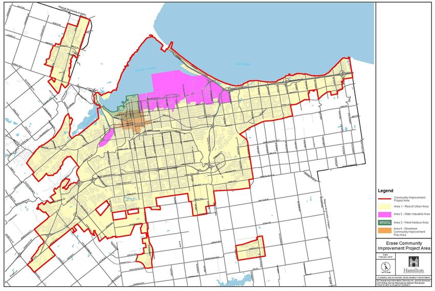
4.0 COMMUNITY IMPROVEMENT PROJECT AREA ........................................................ 21
5.0 COMMUNITY IMPROVEMENT PLANS ........................................................................23
5.1 Community Improvement and Redevelopment Plans............................. 23
5.2 ERASE Community Improvement Plan (CIP) – 2001 ............................. 23
5.3 ERASE Community Improvement Plan (CIP) – 2005 ............................. 23
5.4 ERASE Community Improvement Plan (CIP) - 2010 .............................. 24
5.5 Downtown Hamilton Community Improvement Plan (CIP) ..................... 24
5.6 Hamilton LEEDing the Way Community Improvement Plan (CIP) ......... 24
6.0 PUBLIC PARTICIPATION .......................................................................................... 26
6.1 Notification and Public Participation Procedure ...................................... 26
Page ii
Hamilton ERASE Community Improvement Plan 2018                                                                    Updated: February 2020

PART B            ERASE CIP
7.0    GOALS OF THE ERASE COMMUNITY IMPROVEMENT PLAN (CIP) ......................... 28
8.0    THE ERASE COMMUNITY IMPROVEMENT PLAN (CIP) ............................................ 29
       8.1       ERASE Study Grant Program (ESG) ....................................................... 32
                 8.1.1 Purpose ....................................................................................... 32
       8.2       ERASE Redevelopment Grant Program (ERG) ....................................... 33
                 8.2.1 Purpose ....................................................................................... 33
       8.3       ERASE Tax Assistance Program (TAP) .................................................. 34
                 8.3.1 Purpose ....................................................................................... 34
       8.4       ERASE Downtown Hamilton/West Harbourfront
                 Remediation Loan Program (RLP) ......................................................... 35
                 8.4.1 Purpose ...................................................................................... 35
       8.5       ERASE Municipal Acquisition and Partnership Program (MAPP) ........... 36
                 8.5.1 Purpose ...................................................................................... 36
       8.6       ERASE Marketing and Opportunities Program (MOP) ........................... 37
                 8.6.1 Purpose ...................................................................................... 37

9.0    ERASE DEVELOPMENT CHARGE REDUCTION (DCR) PROGRAM.......................... 38
       9.1       Purpose ................................................................................................... 38
       9.2       Program Description ............................................................................... 38
       9.3       Eligibility Requirements ........................................................................... 39
       9.4       Program Administration........................................................................... 39

10.0   PROGRAM MONITORING AND ADJUSTMENT .......................................................... 41
11.0   CONCLUSION .............................................................................................................. 43
12.0   REFERENCES .............................................................................................................. 44

                                                                                                                                  Page iii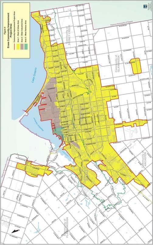
Hamilton ERASE Community Improvement Plan 2018                                                        Updated: February 2020

PART C           APPENDICES
A.    ERASE Study Grant Program (ESG) ............................................................................................. 46
B.    ERASE Redevelopment Grant Program (ERG)............................................................................. 51
C.    ERASE Tax Assistance Program (TAP) ........................................................................................ 60
D.    Downtown Hamilton / West Harbourfront Remediation Loan Program (RLP) ............................... 66
E.    ERASE Municipal Acquisition and Partnership Program (MAPP) ................................................. 71
F.    ERASE Marketing and Opportunities Program (MOP) .................................................................. 73
G.    ERASE Development Charge Reduction (DCR) ........................................................................... 74
H.    ERASE Community Improvement Project Area (2001) ................................................................. 77
I.    ERASE Community Improvement Project Area (2005) ................................................................. 78
J.    ERASE Community Improvement Project Area (2018) ................................................................. 79
K.    Official Plan of the former Regional Municipality of Hamilton-Wentworth ...................................... 80
L.    Comparison of Development Costs – Brownfields vs. Greenfields ............................................... 83
M.    Downtown Hamilton Community Improvement Project Area Boundary ........................................ 87

                                                                                                                            Page iv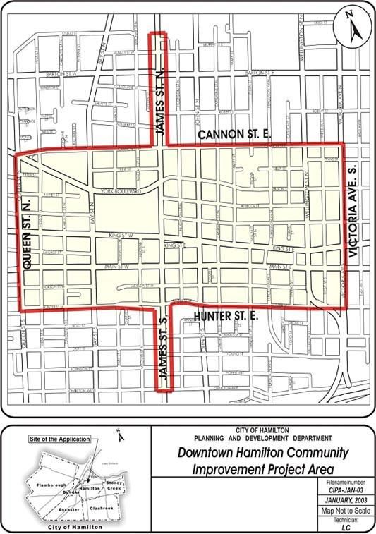
Hamilton ERASE Community Improvement Plan 2018   Updated: February 2020

PART A BACKGROUND

                                                                Page 1
Hamilton ERASE Community Improvement Plan 2018                                    Updated: February 2020

1.0     INTRODUCTION

1.1     What Are Brownfields?
”Brownfields” are defined generally as undeveloped or previously developed properties that may be
 contaminated. They are usually, but not exclusively, former industrial or commercial properties that
 may be underutilized, derelict or vacant (Provincial Policy Statement, 2014, pg. 39). The terms
 “brownfield redevelopment” and “brownfield development” are used interchangeably in this
 document to mean the environmental remediation, rehabilitation and development of brownfields.

The City of Hamilton is one of the oldest and most heavily industrialized cities in Canada. The
 physical legacy of this rich industrial heritage includes a large number of brownfields in Hamilton’s
 older industrial areas, downtown, and throughout the urbanized area.

1.2     The Benefits of Brownfield Development
Numerous Canadian and U.S. studies have highlighted the benefits of brownfield development at all
geographic levels (national, regional and local). Most of the benefits of brownfield development tend
to accrue at the local level because all development, be it brownfield or greenfield, is inherently local.
The benefits of brownfield development include economic, environmental and social benefits.

1.2.1    Economic Benefits

The economic benefits of brownfield development include increased employment, income and tax
revenues at all levels of government. For example, the Spencer Creek Village mixed use brownfield
development project (500 residential units/40,000 sq.ft. commercial space) in Hamilton resulted in a
long-term increase in annual property taxes collected by the City of approximately $1.76 million. This
$95 million project also resulted in $12 million in personal income and $3.6 million in income tax
revenues from on-site remediation and construction jobs, $6.6 million in GST revenues and $7.6
million in PST revenues (NRTEE, 2003, p. A-10-A11).

A 1998 Environment Canada study examined property values on Hamilton’s West Harbourfront near
Bayfront Park, a 40 acre former brownfield site on Hamilton’s West Harbour that was developed and
opened as an open space park by the City of Hamilton in 1994 (Environment Canada, 2004). The
Environment Canada study compared property sale prices for houses within 3,500 feet of the park
with sale prices for a control group of similar houses farther than 3,500 feet away from the park, for
the period 1983-1996. For houses in the study group, the average house price was $41,942 in 1983,
and this had risen to $90,068 by 1996, an increase of 115%. In the control group, the average house
price in 1983 was $55,889, increasing to $74,434 by 1996, an increase of only 33%. The study found
that approximately 18.5% of the aggregate 1996 residential property values in the study area were
attributable to the development of the park and improvements in water quality. The study also
concluded that the increased property values brought about by the park development could have
contributed $560,000 more to the City of Hamilton’s property tax revenues in 1996, if market value
assessment had been in place at the time.

A 1999 Council for Urban Economic Development (CUED) study of 107 completed brownfield
projects found that 23,330 jobs were created or retained by the 90 job generating
redevelopment projects. About 60% were new jobs with the remaining 40% being retained jobs that
were expected to relocate from the area if the property was not redeveloped (CUED, 1999).

                                                                                                   Page 2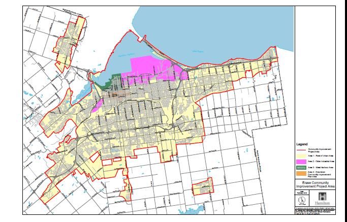
Hamilton ERASE Community Improvement Plan 2018                                  Updated: February 2020

1.2.2    Environmental Benefits

Clearly, the environmental restoration and development of brownfield sites serves to remove threats
to the health of workers and residents in our communities by improving the environmental quality of
our soil and groundwater. But, the positive impact of brownfield development on the environment is
not limited to individual sites. Environmental restoration of individual sites can have a cumulative
positive impact on the environment, including the protection of groundwater resources, wetlands and
wildlife habitat (Regional Analytics, 2002).

A study of brownfield versus greenfield development examined 48 brownfield projects in six cities
across the United States (Deason et. al., 2001). This study found that every acre of brownfield land
developed would have required 4.5 acres of greenfield land. This demonstrates the potential of
brownfield development to reduce the amount of greenfield land being consumed, thereby reducing
urban sprawl and its associated negative environmental impacts including air and water pollution and
the loss of agricultural land. By using existing infrastructure, brownfield development can also reduce
the costs of urban sprawl, including the costs of providing hard and soft services to greenfield areas.

Brownfield projects, be they employment or residential lands, can also reduce the distance between
the location of employment areas and residential areas, and therefore transportation costs. For
example, a study found that every hectare of brownfield land redeveloped for residential purposes
can save as much as $66,000 a year in transportation costs relative to equivalent greenfield
development (Hara Associates, 2003). Therefore, brownfield development can have the effect of
reducing commuting needs, thereby reducing traffic congestion and air pollution.

1.2.3    Social Benefits

While the economic and environmental benefits of brownfield development are more obvious,
brownfield development can also generate significant social benefits at the local level. Based on an
analysis of a dozen brownfield projects across Canada, the NRTEE concluded that brownfield
development can be an engine for urban renewal (NRTEE, 2003, p. 3). Numerous case studies
reviewed by the NRTEE across Canada, including two in Hamilton, showed that this renewal can
take the form of:

•   neighbourhood, employment area and downtown revitalization;
•   improved aesthetic quality of the urban environment;
•   provision of affordable housing opportunities;
•   creation of recreational and public open spaces;
•   improved safety and security; and,
•   an increased sense of community participation and civic pride.

Figure 1 below summarizes the benefits of brownfield development and the interrelationship between
these benefits. For example, the economic benefits resulting from brownfield development, such as
increased incomes and property tax revenues can contribute to social benefits such as
neighbourhood stability and quality of life. Therefore, financial incentive
programs that result in an increase in brownfield development will translate into economic,
environmental and social benefits.

                                                                                                Page 3
Hamilton ERASE Community Improvement Plan 2018                                     Updated: February 2020

Figure 1 – Benefits of Brownfield Redevelopment

                                             Brownfield
                                           Redevelopment

   Economic Benefits                  Social Benefits                    Environmental Benefits
   -   Jobs                           -   Quality of life                -   Mitigation/elimination of
   -   Income                         -   Neighbourhood                      health/safety risks
   -   Taxes                              renewal                        -   Restoration of
   -   Business                       -   Housing choices                    environmental quality
       opportunities                                                     -   Reduced in urban sprawl
                                                                         -   Ecological health

Source: Regional Analytics, 2002, Figure 2, p. 7.

1.3      Purpose of the CIP
It has long been difficult for communities to bring brownfield sites back into productive use because
of the high costs of remediation, uncertainty about the level of contamination at many sites, and
environmental liability issues. More recently in the United States, and even in Canada, governments
at all levels have begun taking action to encourage the cleanup and reuse of brownfield sites. This
stems from a growing understanding of the importance of brownfields to the future of communities
and the public benefits that can be realized through brownfield development. Also, governments at
all levels have realized that traditional polices were not doing a very good job of bringing brownfield
properties back into use (Bartsch et. al, 1997, pp. 1-2).

There are a myriad of complex and interconnected reasons for promoting brownfield development at
all levels of government. This includes the significant economic, environmental and social benefits
that accrue at all geographic levels, but particularly at the local level. This solid “public good”
rationale supports government involvement at all levels in promoting brownfield development. These
public goods include:
 • increased tax assessment for the municipality and the Province;
 • creation and retention of employment opportunities;
 • utilization of existing infrastructure resulting in a reduction of urban sprawl and its related costs
   (hard and soft services);
 • contribution toward the revitalization of particular areas and neighbourhoods; and,
   environmental restoration which can remove threats to the health of workers and residents.

In June of 1999, City Council directed that a Community Improvement Plan (CIP) to promote the
Brownfield redevelopment of industrial and commercial properties in the City of Hamilton be
prepared. The Plan was called the Environmental Remediation and Site Enhancement (Erase)
Community Improvement Plan (CIP) and was adopted by City Council in April of 2001 and approved
by the Minister of Municipal Affairs and Housing in August of 2001. The Erase CIP applies to the
Erase Community Improvement Project Area (2001) generally associated with Hamilton’s older

                                                                                                    Page 4
Hamilton ERASE Community Improvement Plan 2018                                  Updated: February 2020

industrial area (see Appendix A). The ERASE CIP was expanded in April of 2005 for the
improvement and enhancement of financial assistance programs contained in the ERASE CIP and to
expand these programs to the full limits of the urbanized area of the City (see Appendix B). In 2010
the ERASE CIP was further amended adding a Remediation Loan Program (RLP), expansion to the
ERG Programs well as increases to the ESG Program. The Erase CIP has been in place for
approximately sixteen years and has been successful in providing the financial tools needed to
promote the remediation and redevelopment of brownfield sites. The results of the ERASE CIP to
date are presented in Section 5.0 on Previous Community Improvement Plans.

The purpose of the Environmental Remediation and Site Enhancement - Revised (ERASE)
Community Improvement Plan (CIP), is to provide a comprehensive framework for the
improvement and enhancement of financial assistance programs contained in the ERASE CIP, and
the expansion of these programs to the full limits of the urbanized area of the City of Hamilton. As
part of the adoption of this ERASE CIP (2005), the Erase CIP (2001) was repealed by by-law and
replaced by this ERASE CIP (2005).

The programs contained in this ERASE CIP are designed to improve economic opportunities and
environmental conditions not just in the older industrial area of Hamilton, but throughout the urban
area.

                                                                                                Page 5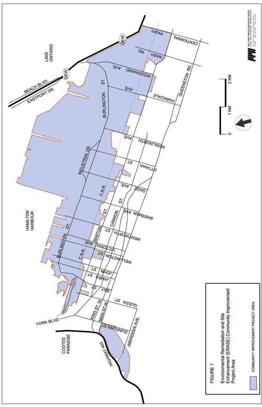
Hamilton ERASE Community Improvement Plan 2018                                    Updated: February 2020

2.0     LEGISLATIVE AUTHORITY AND PLANNING POLICIES

2.1     Legislative Authority
Section 106 of the Municipal Act, 2001 provides that a municipality ‘shall not assist directly or
indirectly any manufacturing, business or other industrial or commercial enterprise through the
granting of bonuses for that purpose’. However, an exception is made in Section 106(3) of the
Municipal Act for municipalities exercising powers under Section 28 (6) or (7) of the Planning Act or
under Section 365.1 of the Municipal Act. This exception provides the legislative basis for the
financial assistance programs contained in Section 7.0 of this Plan.

2.2     Section 28 – Planning Act
Section 28 of the Planning Act allows municipalities with provisions in their official plans relating to
community improvement to designate by by-law a “community improvement project area”.
Once this is done, a municipality may prepare and adopt a “community improvement plan” for the
community improvement project area. Once the community improvement plan is approved by the
Province, the municipality may exercise any power or authority under Section 28(6) or (7) of the
Planning Act in order that the exception provided for in Section 106(3) of the Municipal Act will apply.

According to Section 28(1) of the Planning Act, a “community improvement project area” is defined
as “a municipality or an area within a municipality, the community improvement of which in the
opinion of the council is desirable because of age, dilapidation, overcrowding, faulty arrangement,
unsuitability of buildings or for any other environmental, social or community economic development
reason”. Section 3.0 of this Plan presents the justification for designating the entire Urban Area of the
City of Hamilton as the ERASE Community Improvement Project Area for the purposes of promoting
brownfield redevelopment in the City of Hamilton. The designation of the ERASE Community
Improvement Project Area conforms to the definition of “community improvement project area” under
Section 28(1) of the Planning Act.

For the purposes of carrying out a community improvement plan that has come into effect, a
municipality may engage in the following within the community improvement project area:

a)       acquire, hold, clear, grade or otherwise prepare land for community improvement (28(3));
b)       construct, repair, rehabilitate or improve buildings on land acquired or held by it in
         conformity with the community improvement plan (28(6));
c)       sell, lease, or otherwise dispose of any land and buildings acquired or held by it in
         conformity with the community improvement plan (28(6)); and,
d)       make grants or loans to the registered owners, assessed owners, and tenants, and to any
         person to whom such an owner or tenant has assigned the right to receive a grant or loan,
         to pay for the whole or any part of the cost of rehabilitating such lands and buildings in
         conformity with the community improvement plan (28(7)).

Section 28(7.1) specifies that the total of all grants and loans made under Section 28(7) of the
Planning Act and tax assistance provided under Section 365.1 of the Municipal Act in respect of the
land and buildings shall not exceed the cost of rehabilitating the land and buildings. Section
8.0 of this Plan presents the programs which the City of Hamilton, through adoption and Provincial
approval of this Plan, will implement within the Community Improvement Project Area. These
programs contain eligibility criteria and financial assistance capping safeguards that will ensure that
the total of all grants, loans and tax assistance provided in respect of any lands and buildings shall
not exceed the costs of rehabilitating said land and buildings.
                                                                                                  Page 6
Hamilton ERASE Community Improvement Plan 2018 Updated: February 2020
2.3 Section 365.1 – Municipal Act
Section 365.1(2) and (3) of the Municipal Act allows municipalities to pass a by-law providing tax
assistance to an eligible property in the form of a freeze or cancellation of part or all of the taxes
levied on that property for municipal and school purposes during the rehabilitation period (maximum
18 months from the date that tax assistance begins) and the development period of the property. The
total tax assistance provided on an eligible property cannot exceed the cost of any action taken to
reduce the concentration of contaminants on, in or under the property to permit a record of site
condition (RSC) to be filed in the Environmental Site Registry under Section 168.4 of the
Environmental Protection Act.
An “eligible property” is a property for which a phase two environmental site assessment (ESA) has
been conducted, and,
a) that is included under Section 28 of the Planning Act in a community improvement project
area for which a community improvement plan is in effect containing provisions in respect of
tax assistance, and
b) that as of the date the phase two ESA was completed, did not meet the required standards
under subparagraph 4i of Section 168.4(1) of the Environmental Protection Act to permit an
RSC to be filed in the Environmental Site Registry.
Section 365.1 of the Municipal Act operates within the framework of Section 28 of the Planning Act.
This means that a municipality with an approved community improvement plan in place that contains
provisions specifying tax assistance will be permitted to provide said tax assistance for municipal and
school purposes. Again, Section 28(7.1) specifies that the total of all grants and loans made under
Section 28(7) of the Planning Act and tax assistance provided under Section
365.1 of the Municipal Act in respect of the land and buildings shall not exceed the cost of
rehabilitating the land and buildings.
2.4 Provincial Policy Statement (PPS) (2014)
The Provincial Policy Statement (PPS) is issued under Section 3 of the Planning Act and is intended
to guide municipalities as they make planning decisions. The Planning Act requires that municipal
decisions in respect of the exercise of any authority that affects a planning matter “shall be consistent
with” the PPS.
The PPS supports the remediation and redevelopment of brownfield sites. For example, Section
1.7.1 e) of the PPS states that “long-term economic prosperity should be supported by promoting the
redevelopment of brownfield sites”. Brownfields are defined in the PPS as “undeveloped or
previously developed properties that may be contaminated. They are usually, but not exclusively,
former industrial or commercial properties that may be underutilized, derelict or vacant.
The PPS also supports Smart Growth through urban growth management. For example, Section
1.1.3.3 of the PPS states “planning authorities shall identify and promote opportunities for
intensification and redevelopment where this can be accommodated taking into account existing
building stock or areas, including brownfield sites, and the availability of suitable existing or planned
infrastructure and public service facilities required to accommodate projected needs”. Therefore, the
PPS supports brownfield redevelopment as a way to achieve the goal of promoting intensification and
redevelopment. Other policies in the PPS (Sections 1.1.1 a), 1.1.1 h) and 1.6.3) support the
management of growth to achieve efficient development and land use patterns which sustain the
financial well-being of the Province and municipalities over the long term. The redevelopment of
Page 7Hamilton ERASE Community Improvement Plan 2018 Updated: February 2020
brownfields has a role to play in this regard.
2.5 Growth Plan for the Greater Golden Horseshoe (2017)
The Growth Plan envisages increasing intensification of the existing built-up area, with a focus on
urban growth centres, intensification corridors, major transit station areas, brownfield sites and
greyfields. The ERASE Community Improvement Plan would contribute to the increased intensification
in the built-up area.
The vision for the Greater Golden Horseshoe (GGH) is grounded in the following principles that provide
the basis for guiding decisions on how land is developed; resources are managed and public dollars
invested:
• Achieve complete communities that are designed to support healthy and active living
• Prioritize intensification and higher densities to make efficient use of land and infrastructure and
support transit viability.
• Provide flexibility to capitalize on new economic and employment opportunities as they emerge,
while providing certainty for traditional industries, including resource-based sectors.
• Provide for different approaches to manage growth that recognize the diversity of communities
in the GGH.
• Protect and enhance natural heritage, hydrologic, and landform systems, features, and functions.
• Conserve and promote cultural heritage resources to support the social, economic, and cultural
well-being of all communities, including First Nations and Métis communities.
• Integrate climate change considerations into planning and managing growth such as planning
for more resilient communities and infrastructure – that are adaptive to the impacts of a changing
climate – and moving towards low-carbon communities, with the long-term goal of net-zero
communities, by incorporating approaches to reduce greenhouse gas emissions.
Further, providing opportunities for businesses and residences to locate in the Greater Golden
Horseshoe is fundamental to using land wisely and ensuring a prosperous economic future.
2.6 Regional Municipality of Hamilton-Wentworth Official Plan
(The Official Plan for the former Regional Municipality of Hamilton-Wentworth, “Towards a
Sustainable Region”, clearly recognizes the need to make more productive use of existing municipal
urban infrastructure through redevelopment and re-use of vacant and/or underutilized lands and
buildings. Section 3.1.1 of the Hamilton-Wentworth Official Plan states:
Mixed forms of development within an Urban Area is preferable to widespread, low density
residential development and scattered rural development because growth can be
accommodated by building on vacant or redeveloped land, without taking up agricultural
lands or natural areas.
Section C 3.1.5 of the Hamilton-Wentworth Official Plan states:
Older industrial areas in the Region, specifically the Bayfront Industrial Area in Hamilton,
have witnessed decreasing employment levels. Eventually there may be pressure or a need
to redevelop this land, either for newer industrial/business uses or for other uses. Therefore,
land use plans must begin to reflect this economic restructuring.
Page 8Hamilton ERASE Community Improvement Plan 2018 Updated: February 2020
Amendment No. 11 to the Official Plan of the former Regional Municipality of Hamilton Wentworth
was passed on February 26, 2003. This amendment added a new Section 6A on Community
Improvement Policies to Part D – Implementation, Section 6 – Secondary/Neighbourhood Plans of the
Official Plan of the former Regional Municipality of Hamilton Wentworth (see Appendix B). The
primary purpose of this amendment was to add a new policy to the Official Plan to establish city- wide
community improvement policies. These policies allow a range of community improvement issues
such as brownfields and affordable housing to be addressed across the entire urban area rather than
just in small defined geographic locations. Section 6A.1 clearly permits that the entire Urban Area or
any part of the Urban Area may by by-law be designated as a community improvement project area.
Section 6A.2 sets out the characteristics or criteria to be used when designating community
improvement project areas (see Appendix B). Section 6A.2 requires only that one or more of the
following characteristics be present:
a) building stock or property in need of rehabilitation;
b) buildings and structures of heritage or architectural significance;
c) encroachment of incompatible land uses or activities;
d) deteriorated or insufficient physical infrastructure such as, but not limited to, sanitary and
storm sewers and water mains, public transit, roads/streets, curbs, sidewalks, street lighting
and utilities;
e) deteriorated or insufficient community services such as, but not limited to public
indoor/outdoor recreational facilities, public open space and public social facilities;
f) inadequate mix of housing types;
g) known or perceived environmental contamination;
h) deteriorated or insufficient parking facilities;
i) poor overall visual amenity of the area, including, but not limited to streetscapes and urban
design;
j) existing Business Improvement Areas or potential for inclusion in a Business Improvement
Area designation;
k) inappropriate road access and traffic circulation;
l) shortage of land to accommodate building expansion and/or parking and loading facilities;
m) other barriers to the improvement or redevelopment of underutilized land or buildings; and,
n) any other environmental or community economic development reasons for designation.
As discussed in Section 3.0, properties in the older industrial area exhibit several of these
characteristics, including:
• known or perceived environmental contamination;
• buildings in need of rehabilitation;
• encroachment of incompatible land uses;
• a shortage of land to accommodate building expansion;
• deteriorated infrastructure; and,
• poor overall visual amenity.
Brownfield properties are also spread throughout other parts of the urban area of Hamilton and, as
Page 9Hamilton ERASE Community Improvement Plan 2018 Updated: February 2020
discussed in Section 3.0, these brownfield properties and areas also exhibit some of the same
characteristics as brownfield properties in the older industrial area, including:
• known or perceived environmental contamination;
• buildings in need of rehabilitation;
• encroachment of incompatible land uses;
• a shortage of land to accommodate building expansion; and,
• poor overall visual amenity.
Finally, Section 6A.2 n) also allows designation of a community improvement project area for any
other environmental or community economic development reason. Section 1.0 outlines numerous
environmental, economic and social reasons (benefits) for the designation of the urban area as a
community improvement project area for the promotion of brownfield redevelopment.
Therefore, the designation of the entire Urban Area of the City of Hamilton as the ERASE
Community Improvement Project Area meets the criteria for designation of a community
improvement project area specified in the Official Plan of the former Regional Municipality of Hamilton
Wentworth.
Section 6A.3 of the Official Plan outlines the actions which the City can take through community
improvement plans. This includes:
a) provision of grants and loans;
b) acquisition of land or buildings and subsequent clearance, rehabilitation, redevelopment or
resale of these properties or other preparation of land or buildings for community
improvement; and,
c) other municipal actions, programs or investments for the purpose of strengthening and
enhancing neighbourhood stability, stimulating production of a variety of housing types,
facilitating local economic growth, improving social or environmental conditions, or promoting
cultural development.
2.7 Urban Hamilton Official Plan
The City of Hamilton Urban Official Plan has numerous policies directed towards achieving an efficient,
well planned and supportive approach to land use planning. With particular regard to Community
Improvement Plan’s Policy 1.15.1 is considered applicable:
Community Improvement shall be carried out through the designation, by Council, of Community
Improvement Project Areas and through the preparation and implementation of Community
Improvement Plans pursuant to the Planning Act. It is the intent of Council that the entire urban area
or any part of the urban area as defined in this Plan, and as subsequently amended, may by by-law
be designated as a Community Improvement Project Area.
Policy 1.15.2 sets out the criteria to be used when designating community improvement project areas:
When designating Community Improvement Project Areas, one or more of the following
characteristics may be present:
a) building stock or property in need of rehabilitation;
b) buildings and structures of heritage or architectural significance;
Page 10Hamilton ERASE Community Improvement Plan 2018 Updated: February 2020
c) encroachment of incompatible land uses or activities;
d) deteriorated or insufficient physical infrastructure such as, but not limited to, sanitary and
storm sewers and water mains, public transit, roads/streets, curbs, sidewalks, street lighting
and utilities;
e) deteriorated or insufficient community facilities/services such as, but not limited to public
indoor/outdoor recreational facilities, public open space and public social facilities;
f) inadequate mix of housing types;
g) inadequate affordable housing;
h) known or perceived environmental contamination;
i) deteriorated or insufficient parking facilities;
j) poor overall visual amenity of the area, including, but not limited to streetscapes and urban
design;
k) existing Business Improvement Areas or potential for inclusion in a Business Improvement
Area designation, provided such designation is in conformity with the Niagara Escarpment
Plan;
l) inappropriate road access and traffic circulation;
m) shortage of land to accommodate building expansion and/or parking and loading facilities;
n) other barriers to the improvement or redevelopment of underutilized land or buildings; or,
o) any other environmental, social, or community economic development reasons for
designation.
As discussed in Section 3.0, properties in the older industrial area and brownfields throughout the
urban area of Hamilton exhibit several of these characteristics, including:
• known or perceived environmental contamination;
• building stock or property in need of rehabilitation;
• encroachment of incompatible land uses or activities;
• shortage of land to accommodate building expansion and/or parking and loading facilities; and,
• poor overall visual amenity of the area, including, but not limited to streetscapes and urban
design.
With particular regard to the development and redevelopment of brownfield Sites Policy 3.1.5, is
applicable:
There are many complex and interconnected reasons for promoting and implementing brownfield
redevelopment. There are significant and immediate economic, environmental and social benefits
from regenerating these "legacy" properties. The City, in addition to other economic development
objectives, shall pursue the redevelopment of brownfield sites and promote opportunities for
employment and residential intensification by:
a) continuing to liaise with other levels of government, agencies, and the private sector to
endorse and amend existing legislation, regulations and standards, including the addressing
of liability issues for land owners;
b) undertaking studies to identify priority brownfield sites for redevelopment;
c) providing the necessary financial assistance to developers and landowners to make the
Page 11Hamilton ERASE Community Improvement Plan 2018 Updated: February 2020
redevelopment of brownfield sites a viable option; and,
d) ensure a wide variety of investment opportunities are available throughout the City and
provide potential employment users with a range of alternative sites of various size in a
variety of locations throughout the City.
The continuous review and improvement of the ERASE CIP will secure this policy intent, providing
financial support in order to facilitate efficient development.
2.8 2016-2025 Strategic Plan
The Strategic Plan 2016-2025 is a detailed strategy intending to secure the vision of making Hamilton
the ‘best place to raise a child and age successfully’. The strategy’s mission is ‘To provide high quality
cost conscious public services that contribute to a healthy, safe and prosperous community, in a
sustainable manner.
2.9 Central Neighbourhood Plan
The Central Neighbourhood Plan was adopted by City Council in 1999. This Plan generally
designates the lands around the Downtown Secondary Plan area between Cannon Street and the
Bayfront Industrial area from Queen to Victoria Street extending south between Victoria Avenue and
Wellington Street to Main Street and includes a small area south of the downtown in the vicinity of
James and John Streets, for mixed use with residential being a primary component.
The Central Neighbourhood Plan provides for:
i) open space connections to the waterfront through this area;
ii) compatibility of land uses, especially with adjoining residential areas; and,
iii) final determination of land uses to be done through a modified neighbourhood plan review.
2.9 Downtown Secondary Plan: Putting People First
The Downtown Secondary Plan was approved by Council on July 10, 2001. The Plan takes an
innovative approach, focusing on the overall roles and physical form of the Downtown rather than
dwelling on regulatory details. The intent of the Plan is to foster a dynamic mix of urban residential,
commercial and institutional activities across the Downtown.
2.10 West Harbourfront Development Study
The West Harbourfront Development Study (WHDS) was an initiative to generate a vision to guide
the future redevelopment of the West Harbourfront Area. This vision sees the West Harbourfront
area as a mixed-use area with residential, commercial, cultural, park/open space and major
attraction uses. Public use and enjoyment of the West Harbourfront Area is a primary objective of the
WHDS. While the WHDS was received by Council, it does not have status as a land use plan for the
area. A detailed Secondary Plan was developed for the West Harbour Area as part of the Setting Sail
planning project.
2.11 Setting Sail
Setting Sail is the City's long-term planning project for Hamilton's West Harbour (see Figure 2
Setting Sail is the City's long-term planning project for Hamilton's West Harbour (see Figure 2 for West
Page 12Hamilton ERASE Community Improvement Plan 2018 Updated: February 2020
Harbour Study Area). The West Harbour Area has witnessed tremendous change in recent years, led
by the City’s investments in Pier 4 and Bayfront Parks and the creation of the Waterfront Trail. The
City of Hamilton and the Hamilton Port Authority (formerly the Hamilton Harbour Commissioners) also
reached an agreement in 2000 on future land use that sees a separation of recreational uses in the
West Harbour Area from industrial port uses in the East Harbour Area.
The main objective of the Setting Sail Study is to create a series of integrated plans that will guide
investment and development in the West Harbour Area. The Setting Sail Study is broad and includes
consideration of land use, transportation, infrastructure and urban design.
One of the specific elements of the Setting Sail Study is a strategy to realize the revitalization and
conversion of older industrial areas in the West Harbour to non-industrial uses. In this context, there
are a few remaining operational industrial uses in and near the Tiffany Block which is bounded by Bay,
Stuart and Barton Streets and the relocation of these few remaining industrial uses to industrial areas
outside the West Harbour Area would help facilitate redevelopment of the West Harbour Area for non-
industrial uses.
Figure 2 – Setting Sail West Harbour Study Area
2.12 Planning for Future Land Use
With its existing nucleus of industrial users and 80-90% of its land in industrial use, most of the older
industrial area will realistically remain zoned and used primarily for heavy industry and
manufacturing. Suitably sized land parcels zoned for such purposes are becoming increasingly
difficult to locate in Ontario because most municipalities are no longer zoning land for heavy or even
limited heavy industrial uses. Yet, there continues to be a demand for heavy industrial and
manufacturing type of land in the Hamilton area. This demand is best met in the older industrial
areas due to the current existence of these types of uses in these areas and restrictive zoning in
greenfield industrial areas. One of the main goals of this Plan is to promote the redevelopment of
vacant, idled and underutilized industrial land in the older industrial area for new industrial and other
employment uses that generate employment and economic benefits for the City and its residents.
There are opportunities in areas of transition within the older industrial area to convert industrial
lands to other productive uses such as commercial, institutional, residential and parkland uses. This
is particularly the case in the West Harbour Area, currently the subject of the Setting Sail Study. This
area, west of Wellington Street, contains a mix of several large stable residential areas and several
smaller areas containing existing and former industrial uses. The condition of the residential building
stock in this area is much better than that in the smaller residential enclaves in the interior of the
older industrial area as the residential area around the West Harbour has benefited greatly from its
Page 13Hamilton ERASE Community Improvement Plan 2018 Updated: February 2020
proximity to Bayfront Park and Pier 4 Park.
The West Hamilton Industrial Area is also an area in transition. While currently zoned and designated
for industrial use, it is a small area with no possibilities for expansion. It is bordered to the west by
Highway 403 and to the east by a large residential area. Due to its small size, excellent location, and
a recent major plant closure, this area is also a prime candidate for transition over time to non-
industrial uses.
Consequently, in recognition of the Central Neighbourhood Plan, the WHDS, the agreement between
the City of Hamilton and the Hamilton Port Authority, and the planning policies that form the Setting
Sail Study, this Plan recommends that redevelopment in the older industrial area west of Wellington
Street, i.e. the West Harbour Study Area, be targeted primarily for non-industrial uses, while
redevelopment east of Wellington Street in the older industrial area be targeted primarily for industrial
and commercial uses. With regard to the West Harbour Study Area, the programs in this Plan
generally:
• assist the conversion of existing industrial uses to non-industrial uses and the relocation of
existing industrial uses to industrial areas outside the West Harbour Area.
This will help to ensure that proposed land uses in the West Harbour Area that do not conform to the
Central Neighbourhood Plan and the WHDS are in no way promoted, and are in fact discouraged, by
the incentive programs in this Plan. This represents a realistic and balanced approach to future land
use planning in the West Harbour Area.
The expansion of the community improvement project area to include the entire urban area provides
considerable opportunity for brownfield redevelopment throughout the City. This will no doubt lead to
the consideration of land use changes on brownfield properties through the Planning Act approval
process. As with new development, all redevelopment projects will be evaluated on an individual
basis, having regard for a number of policies and by-laws, including conformity with this Plan, the
Official Plan, Zoning By-law, and all other City policies.
2.13 Summary of Planning Policies
The redevelopment and rehabilitation of the older industrial areas in the City of Hamilton is a key theme
in the Urban Hamilton Official Plan. The use of financial tools to direct future urban development to
curb urban sprawl and increased awareness of the potential for redevelopment and rehabilitation of
contaminated brownfield sites are encouraged within the 2016-2025 Strategic Plan.
The Urban Hamilton Official Plan sets out the required framework as per Section 28 of the Planning
Act for the preparation of a Community Improvement Plan (CIP) to promote the redevelopment of
brownfields in Hamilton’s older industrial areas and throughout the urban area. The designation of the
entire Urban Area as the ERASE Community Improvement Project Area and the preparation, adoption
and amendment of this ERASE CIP is in conformity with, and supported by, existing planning policies.
Through its programs contained herein, this CIP also emphasizes particular land uses in various areas
within the Community Improvement Project Area that are in keeping with future planned land uses.
Page 14Hamilton ERASE Community Improvement Plan 2018 Updated: February 2020
3.0 CRITICAL NEEDS ANALYSIS OF BROWNFIELDS IN HAMILTON
3.1 The Geography of Brownfields in Hamilton
3.1.1 Older Industrial Area
The historic development of the City of Hamilton as a port city at the western end of Lake Ontario
with good rail and road access resulted in the growth of Hamilton as one of Canada’s major
manufacturing centers. In the early 1900’s, Hamilton’s major steel producers (Stelco and Dofasco)
located in the Bayfront Industrial Area where they had easy access to the port for importing raw
materials and rail for exporting finished product. Canadian steel production becoming increasingly
centered in Hamilton in the post-war years and the Bayfront Industrial Area expanded to just over
3,000 acres in size, largely through the placement of fill into Hamilton Harbour to create land for new
industrial uses. The much smaller North Hamilton Industrial Area (70 acres), West Hamilton
Industrial Area (250 acres) and part of the East Hamilton Industrial Area (65 acres) were also
developed for industrial uses. Hamilton’s older industrial area totals approximately 3,400 acres of
land and forms the original ERASE Community Improvement Project Area for the ERASE
Community Improvement Plan adopted and approved in 2001 (see Appendix B).
Significant structural changes in the post-war Canadian economy had far-reaching implications for
steel and related industries, and of course, the Bayfront Industrial Area. Combined employment at
Stelco and Dofasco increased steadily during the 1960’s and 70’s, peaking at approximately 30,000
in the late 1970’s (Woods, Gordon and Co.1977). By 1990, this figure had dropped to 23,000
(Regional Municipality of Hamilton-Wentworth, 1990). Currently, this figure stands at approximately
12,500 (Human Resources Development Canada Web Site, 2003), or about 40% of what it was just
25 years ago. Related industries also suffered large employment losses with many smaller
manufacturers downsizing and ceasing production altogether. The result has been a significant
decrease in business activity and employment levels in Hamilton’s older industrial area over the last
25 years. These economic changes have resulted in some property and building deterioration in the
older industrial areas, and in some cases, property abandonment. Due to the placement of vast
quantities of contaminated fill and contamination from former industrial uses in the Bayfront Industrial
Area, this area now contains many of the city’s brownfield sites. Preliminary estimates indicate that
there are hundreds of vacant, idled and underutilized buildings and properties in the Bayfront
Industrial Area. Some of these properties are not adequately secured and are routinely subject to
trespassing and vandalism causing concern for public safety.
The building stock within the older industrial area is also older than the rest of the city. Many former
industrial buildings lie abandoned, derelict and in a state of disrepair. These buildings also suffer
from obsolescence in that they are not of sufficient ceiling height and internal configuration to meet
modern manufacturing and warehousing requirements. Many of the properties on which these
buildings stand can only be reused if these buildings are demolished. Other buildings have been torn
down leaving only vacant lots. Because of past industrial use and the fact that much of this area is
built on contaminated soils that were placed as fill, many of these properties may have some level of
environmental contamination. But, the existence and extent of environmental contamination varies
from property to property and cannot be determined without a thorough environmental site
investigation of each property.
Many of the brownfield sites in the older industrial area are serviced by on site sewer and water lines
that are over 60 years old. Many of these services have not been replaced and are simply not
adequate for modern industrial/commercial uses, including modern fire suppression
requirements. Therefore, there is often a need to remove and replace part or all of the on-site sewer
and water services in the older industrial area.
Page 15Hamilton ERASE Community Improvement Plan 2018 Updated: February 2020
3.1.2 West Harbour Area
In addition to the issues affecting the rest of the older industrial area as discussed above,
redevelopment of the West Harbour Area for non-industrial uses is contingent upon conversion or
relocation of the few remaining industrial uses in this area, and mitigation of the impacts of the C.N.
Marshalling Yard. Some of the industrial uses in the West Harbour Area are viable industrial uses
that could relocate to larger and more stable industrial areas and continue operation. However, the
costs of relocation, such as moving equipment and machinery, particularly for large and well-
established industrial manufacturers, may be prohibitive.
Also, the redevelopment of the West Harbour Area is complicated by the existence and operation of
the 110 acre C.N. Rail Marshalling Yard which could present a land use compatibility issue with non-
industrial uses in this area.
3.1.3 Rest of Urban Area
The older industrial area is certainly not the only area where brownfields exist in Hamilton. Downtown
Hamilton has been the location of numerous past uses that could have potentially caused soil and
groundwater contamination. This includes asphalt plants, petroleum storage, automobile wrecking
yards, blacksmiths, textile mills, paint manufacturers, printers, dry cleaners and electroplaters. Some
of these uses still exist in Downtown Hamilton. Several recent developments on properties in
Downtown Hamilton had to remediate soil and groundwater contamination and several proposed
downtown developments have been abandoned or delayed indefinitely as a result of environmental
contamination.
As the City of Hamilton grew outward, older industrial uses in and near the downtown core were
replaced by commercial and other uses. Gasoline and automobile service stations began to
proliferate to serve an expanding and suburbanizing population increasingly dependent on
automobiles as their primary mode of transportation. Business and personal services such as dry
cleaners began to move farther from the downtown. Industrial and manufacturing uses such as
metals manufacturers, glass manufacturers, chemical manufacturers, and concrete plants, were also
established in areas farther from Downtown Hamilton.
As each of the former six municipalities which now make up Hamilton grew, similar industrial and
commercial uses were established (on a much smaller scale) and the same pattern of outward
expansion of their central areas was repeated. For example, a small manufacturing area with a steel
foundry was established in downtown Dundas in the late 1800’s. Individual uses that could have
caused contamination, e.g. blacksmith shops, were established in Ancaster. Several of the former
municipalities, including Stoney Creek, contain automobile wrecker’s yards. Even several elementary
and high school sites that were recently redeveloped for residential purposes were found to have
underground and above ground fuel oil storage tanks. Clearly, all of these uses can and, in some
cases, did cause soil and groundwater contamination. Therefore, brownfield sites are now found in
Downtown Hamilton, in the downtowns of the former municipalities, and they are also spread
throughout the urban area, including properties once used for industrial and commercial uses, such
as gasoline and automobile service stations.
Another source of brownfield sites in Hamilton are former waste disposal sites. A recent inventory of
waste disposal sites confirms that there are no less than 44 known waste disposal sites in the City of
Hamilton (see Figure 3). Most of these sites have been closed for more than 25 years. These are
only the known sites. There are most certainly more private waste disposal sites for which records do
not exist.
Figure 3 clearly shows that waste disposal sites are spread throughout the urban and rural area, with
Page 16Hamilton ERASE Community Improvement Plan 2018 Updated: February 2020
a concentration of sites in the Bayfront Industrial Area, West Hamilton and the Community of
Dundas. Several of these waste disposal sites have been redeveloped as parks and the City also
approved a proposal for a large industrial development on one of these former waste disposal sites.
This industrial development proposal is supported by an Erase Redevelopment Grant which will be
used by the new owner to assist with remediation costs on the site.
3.1.4 Historical Land Use Inventory
In late 2007, the City of Hamilton retained MMM Group Limited to complete a Historical Land Use
Inventory (HLUI). The City identified the need for a comprehensive GIS-based inventory of potential
historically environmentally-impaired properties that was to become a resource to the efficient and
consistent implementation of the City’s brownfield redevelopment programs. The key goals of the
HLUI was to: provide key information to the City’s property management database concerning
historical environmental conditions that had not been previously available at a central location; serve
as a fundamental tool for use by City staff in planning and conducting the everyday aspects of
managing properties within the City in a thoughtful and conscientious manner; and ensure that
management staff have the information necessary for knowledgeable decisions concerning
brownfield redevelopment planning.
The actual project consisted of reviewing numerous sources of historical environmental information
with the intent to identify properties of interest and potential contaminants associated with them.
While some data came from primary sources that confirm impairment or remediation of a property
(e.g. Phase II Environmental Site Assessment reports or Records of Site Conditions), much of the
require data needed to be interpreted from secondary sources (e.g. fire insurance plans, land use
designation, etc.) combined with the use of industry-specific environmental databases to infer the
potential contaminants that may be associated with historical onsite activities.
Once the required data was documented, it was transposed into a Historical Environmental
Database (HED). In total, the study area encompassed approximately 131,000 individual properties.
Of those properties studied throughout the entire urban area of the City, 91 properties were identified
as vacant “true” brownfield sites, mostly in the Older Industrial Area (Area 2). 1386 properties were
identified as having a potential for some contamination based on the historical use of the property
spread throughout the Downtown (Area 4) and the Rest of the Urban Area (Area 1).
Page 17You can also read